Chapter 19 - Cretaceous Mannville Group of the Western Canada Sedimentary Basin |
|
| Chapter Sections | Download |
|
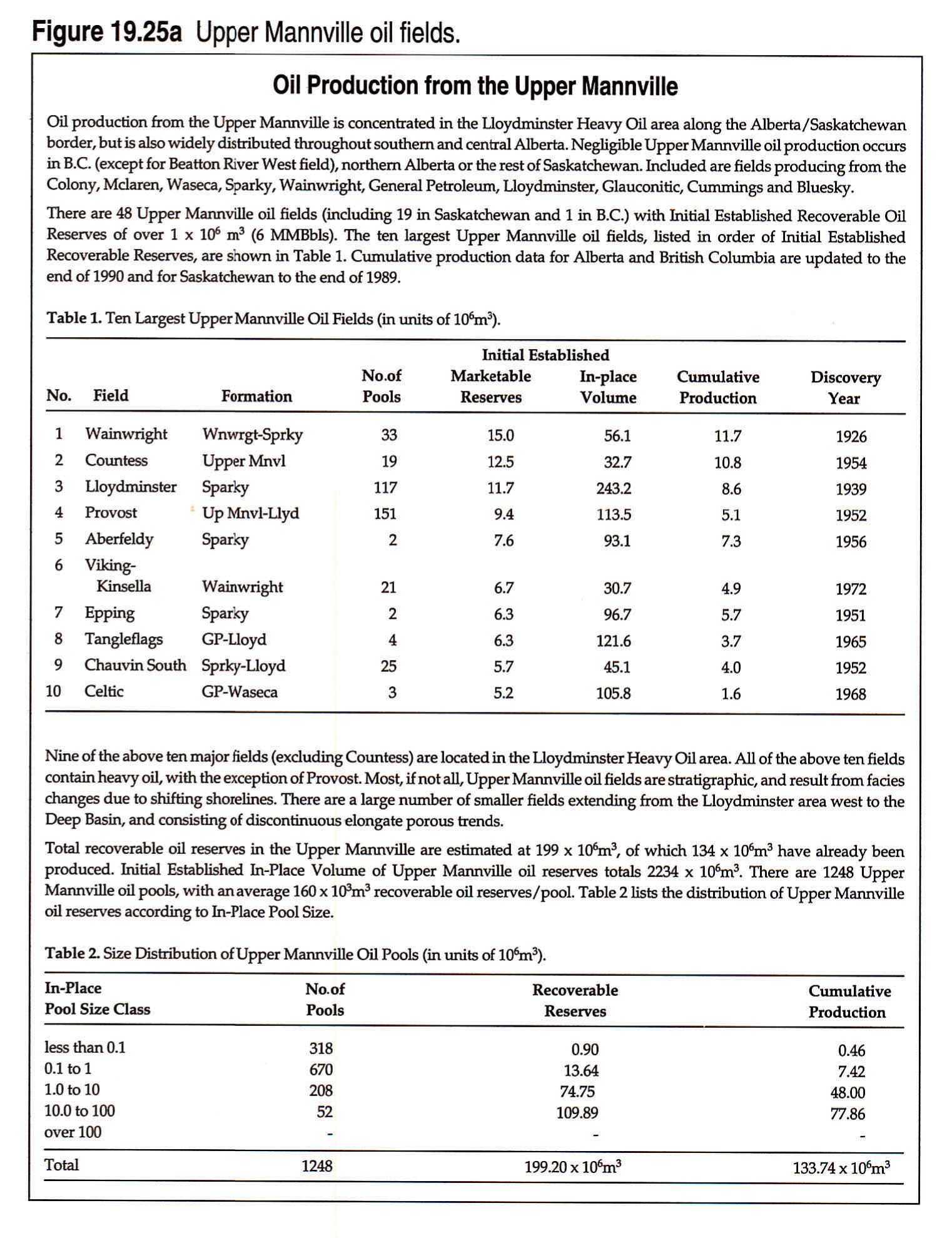
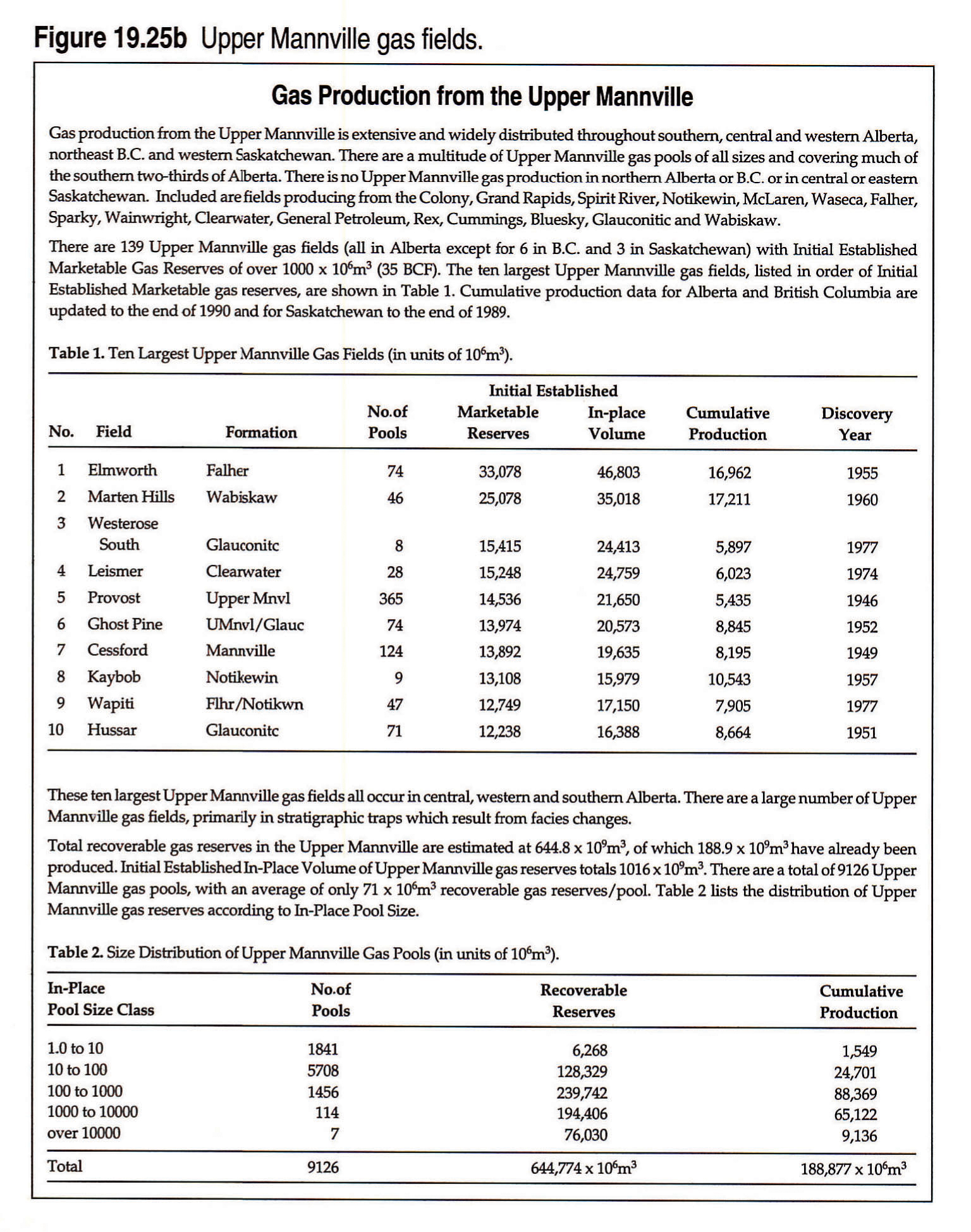
Tables: Figure 19.23a Oil production from the Lower Mannville. Figure 19.23b Gas production from the Lower Mannville. Figure 19.25a Oil production from the Upper Mannville. Figure 19.25b Gas production from the Upper Mannville. |
|
Authors: B.J.R. Hayes - Dorset Exploration Ltd., Calgary J.E. Christopher - Geological Consultant, Regina L. Rosenthal - Consultant, Calgary G. Los - Consultant, Calgary B. McKercher - Inuvialuit Petroleum Corp., Calgary D. Minken - Maryanne Petroleums Limited, DeWinton Y.M. Tremblay - Glyde Resources, Calgary J. Fennell - Consultant, Calgary Additional Contributors: D.G. Smith - Canadian Hunter Exploration Ltd., Calgary
Introduction
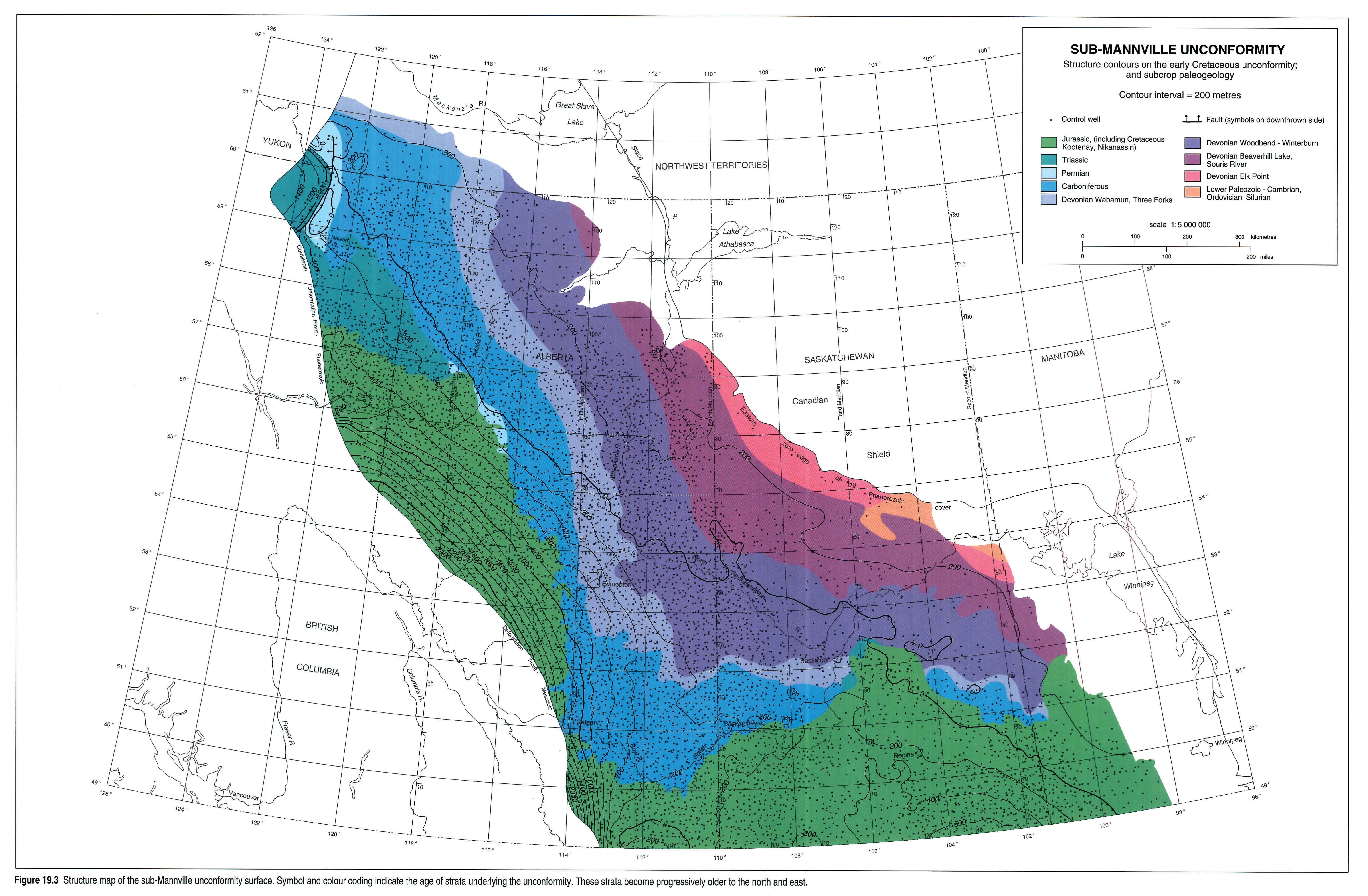
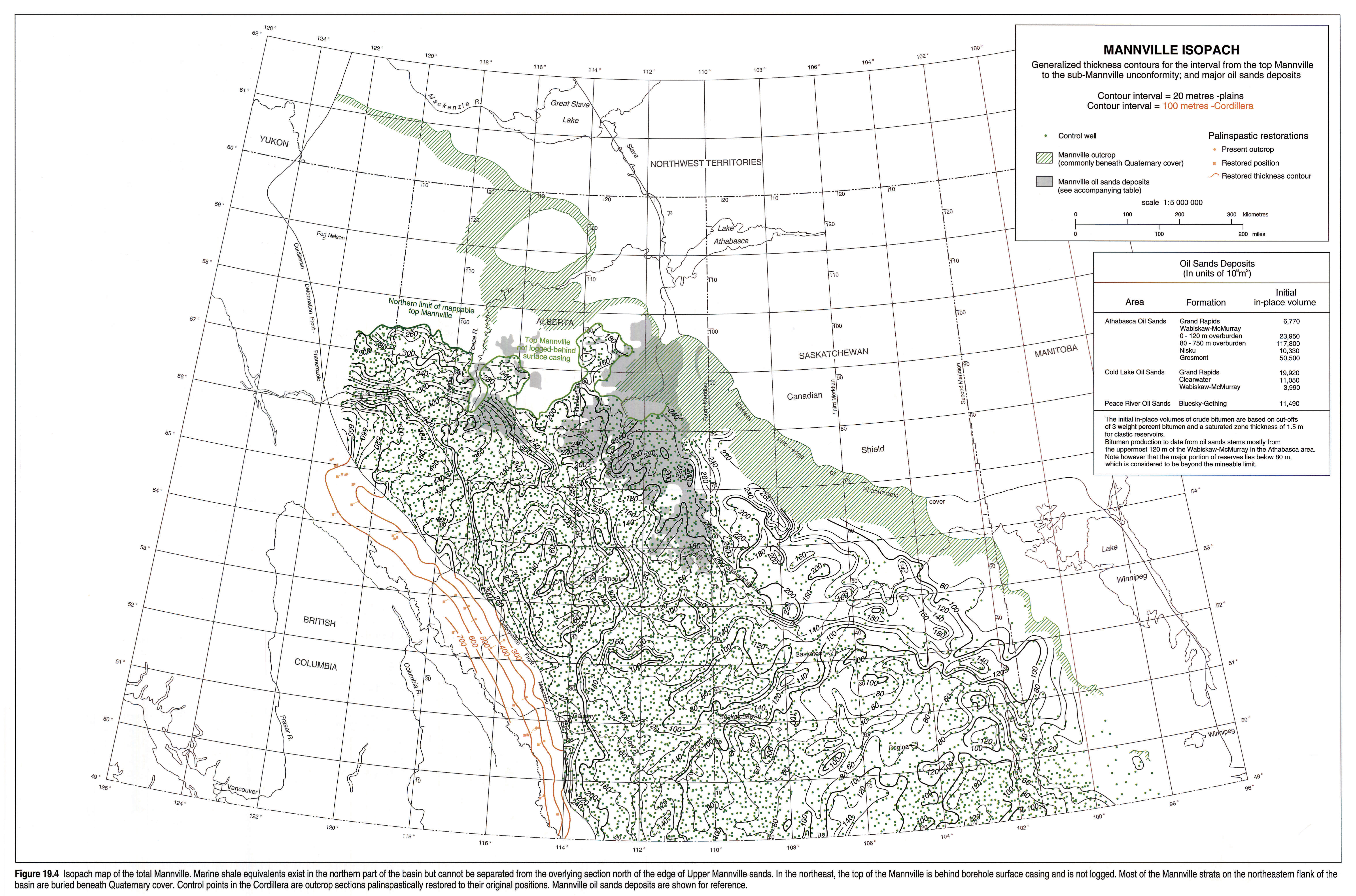
Mannville Group and equivalent strata comprise the oldest Cretaceous rocks over most of the Western Canada Sedimentary Basin (Figs. 19.1, 19.2) and represent a major episode of subsidence and sedimentation following a long period of uplift, exposure and erosion of older strata (Fig. 19.3). Throughout the text all strata within the generally unconformity-bounded interval are referred to as the Mannville. Precise age determinations are difficult to make because most fossiliferous marine strata are restricted to the northern part of the basin, and index fossils are rare in the continental to brackish sections farther south (Fig. 19.2). Mannville strata blanket the entire basin, ranging from less than 40 m thick in some areas of the plains to more than 700 m thick in the Rocky Mountain Foothills (Fig. 19.4). The section is erosionally truncated along its eastern and northeastern limits. Mannville strata are not mapped as a distinct unit in northwestern Alberta and northeastern British Columbia, where they grade into marine shales that cannot be readily distinguished from younger and older marine strata (Fig. 19.4).
Enormous reserves of coal, natural gas, and conventional and heavy oils are found in the Mannville (Smith et al., this volume, Chapter 33; Hay, this volume, Chapter 32). Coals deposited on extensive low-lying coastal plains are preserved primarily in the present-day foothills and adjacent western plains. Oil and gas are trapped in numerous fluvial and valley-fill reservoir sandstones in the south, and in more regionally extensive shoreline sandstone complexes throughout northern and central regions. The latter category includes the giant heavy oil and oil sands accumulations of Alberta and Saskatchewan (Fig. 19.4).
Geological control for the Mannville is extensive, including abundant petroleum borehole data, outcrop and open pit exposures in the northeastern Alberta oil sands area, and outcrop and coal mine exposures in the Rocky Mountain Foothills. Outcrop exposures are poor along most of the northeastern edge, however, and petroleum borehole data are insufficient for detailed mapping of the interval in the Liard Basin in the extreme northwest.
Previous Work
Because Mannville strata are extremely widespread and heterogeneous, few comprehensive syntheses of the entire group exist. Rudkin (1964) reviewed the Lower Cretaceous of the entire basin, but more recent overview papers have been more geographically limited (e.g., Jackson, 1984).
Some excellent original works of regional scope do exist, however. Stott (1968, 1973, 1982) examined Mannville strata in foothills outcrops and the adjacent subsurface throughout northwestern Alberta, northeastern British Columbia, and the southern Northwest Territories. Glaister (1959; southern plains), Williams (1963; central plains), and Mellon (1967; Rocky Mountain Foothills and plains) described and interpreted Mannville deposits over large areas of Alberta. Subsequent regional work in Alberta has focussed on more restricted stratigraphic intervals and/or areas: McLean (1977, 1982) on parts of the Mannville section in the foothills; Smith et al. (1984) on the "Deep Basin", adjacent to the northernmost foothills of Alberta; Macdonald et al. (1988) on the central foothills; McLean and Wall (1981) on deposits of the mid-Mannville Moosebar Sea across Alberta, and Rosenthal (1988) on related strata of west-central Alberta; Hayes (1986) on the lower Mannville of the southern Alberta plains; Gross (1980) and Putnam (1982) on the east-central plains; and Harrison et al. (1981), Flach (1984) and Keith et al. (1988) on the oil sands of the northeastern Alberta plains.
Christopher (1974) described the Mannville Group of the southwestern part of Saskatchewan, and later synthesized the Mannville depositional history of the entire province (Christopher, 1984). Little has been written on the poorly exposed Mannville section of Manitoba, which was reviewed by McNeil (1984).
Geological Framework
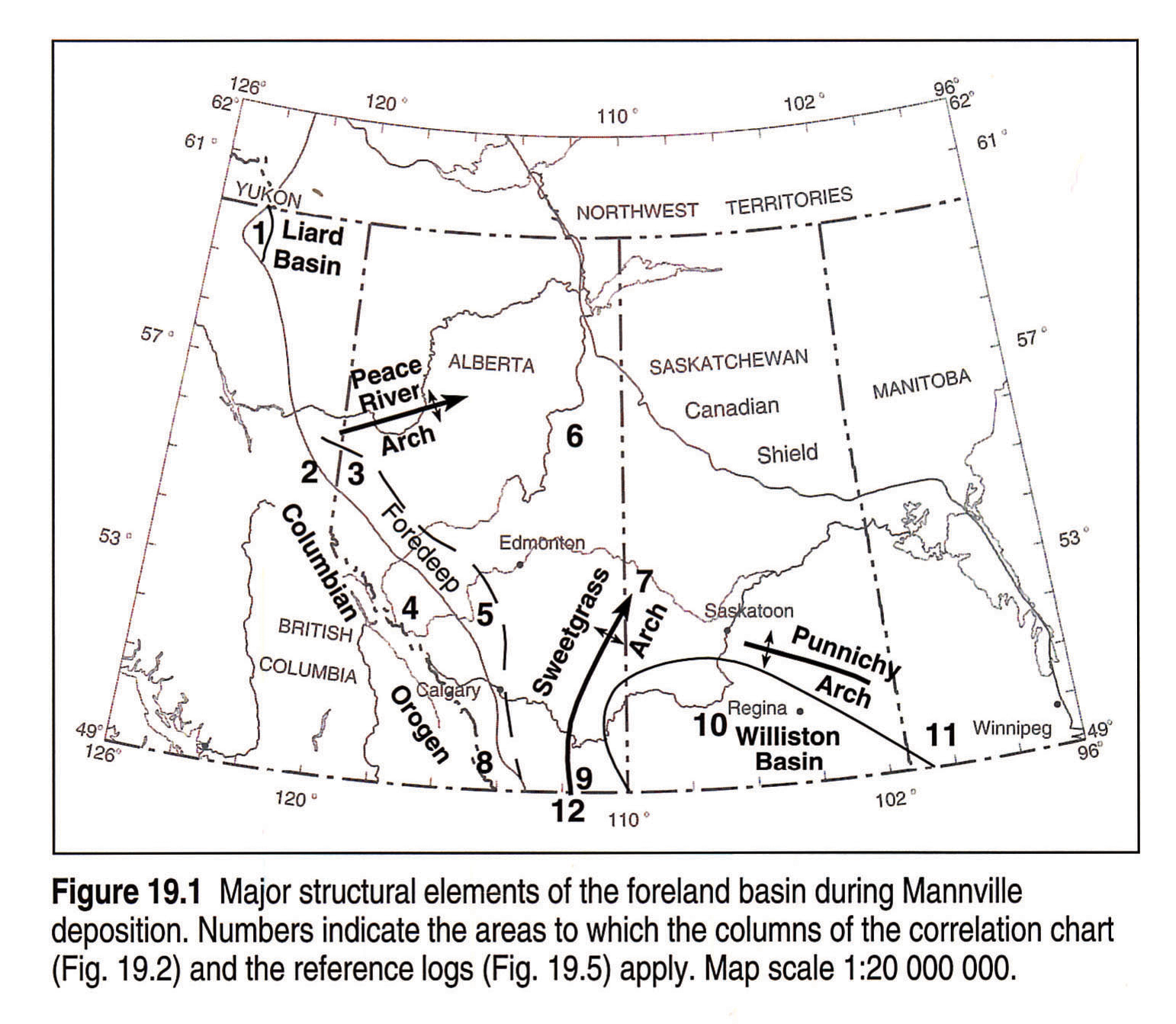
Mannville strata make up the second major Cordilleran-derived clastic wedge of the foreland basin, and record the first basin-wide sedimentation (Smith, this volume, Chapter 17). During the Early Cretaceous, accretion of allochthonous terranes in the western Cordillera compressed older miogeoclinal rocks and thrust them onto the continental margin. Stacked thrust sheets loaded the craton edge and caused it to subside, providing accommodation in the foredeep for the huge volume of sediments shed from the upthrusted sheets (Smith, this volume, Chapter 17). Mannville deposition was initiated as these sediments were introduced to the foreland basin, and as base level began to rise in advance of an Early Albian transgression of the Boreal Sea.
Within the foreland basin, several tectonic elements influenced Mannville sedimentation (Fig. 19.1). Three elements - the foredeep, Peace River Arch and Liard Basin - were regional depocentres. Mannville strata thicken abruptly westward from an eastern hingeline toward the foredeep. The Peace River Arch is a block-faulted basement feature that was high during Devonian time, but was a marked low during the Early Cretaceous (O'Connell, this volume, Chapter 28). The thickest Mannville section is preserved where the Peace River Arch and the foredeep converge in northeastern British Columbia (Fig. 19.4). A thick Mannville succession is also found in the fault-bounded Liard Basin, but this area has not been extensively drilled and is documented only in reconnaissance studies (Leckie et al., 1991).
In contrast, the Williston Basin did not subside actively during Mannville deposition. To the west of Williston Basin, the Sweetgrass Arch, a basement feature similar to the Peace River Arch, was uplifted during the earliest Cretaceous and was part of a positive area that was not covered until late in Mannville deposition. The northeastern edge of the Williston Basin was defined by the Punnichy Arch, which formed as the Devonian Prairie Evaporite dissolved in flanking areas to the south and north (Christopher, 1984). Mannville strata thicken north of the Punnichy Arch, where salt solution provided accommodation and abundant clastics were supplied from the Precambrian Shield (Jackson, 1984; Fig. 19.4).
Mannville deposition took place over a profound unconformity surface that truncates strata ranging from lowermost Cretaceous in the foothills to lower Paleozoic at the eastern margin of the basin (Fig. 19.3). Huge valley systems that cut into the unconformity surface influenced sedimentation patterns of the entire Mannville, as discussed below. Although it has been suggested that relief on the unconformity was controlled by tectonic factors (e.g., Christopher, 1984), Cant and Stockmal (1989) considered that differential erosion of dipping Paleozoic carbonate units also may have influenced valley and highland formation across the central plains.
Stratigraphy
Stratigraphic Nomenclature
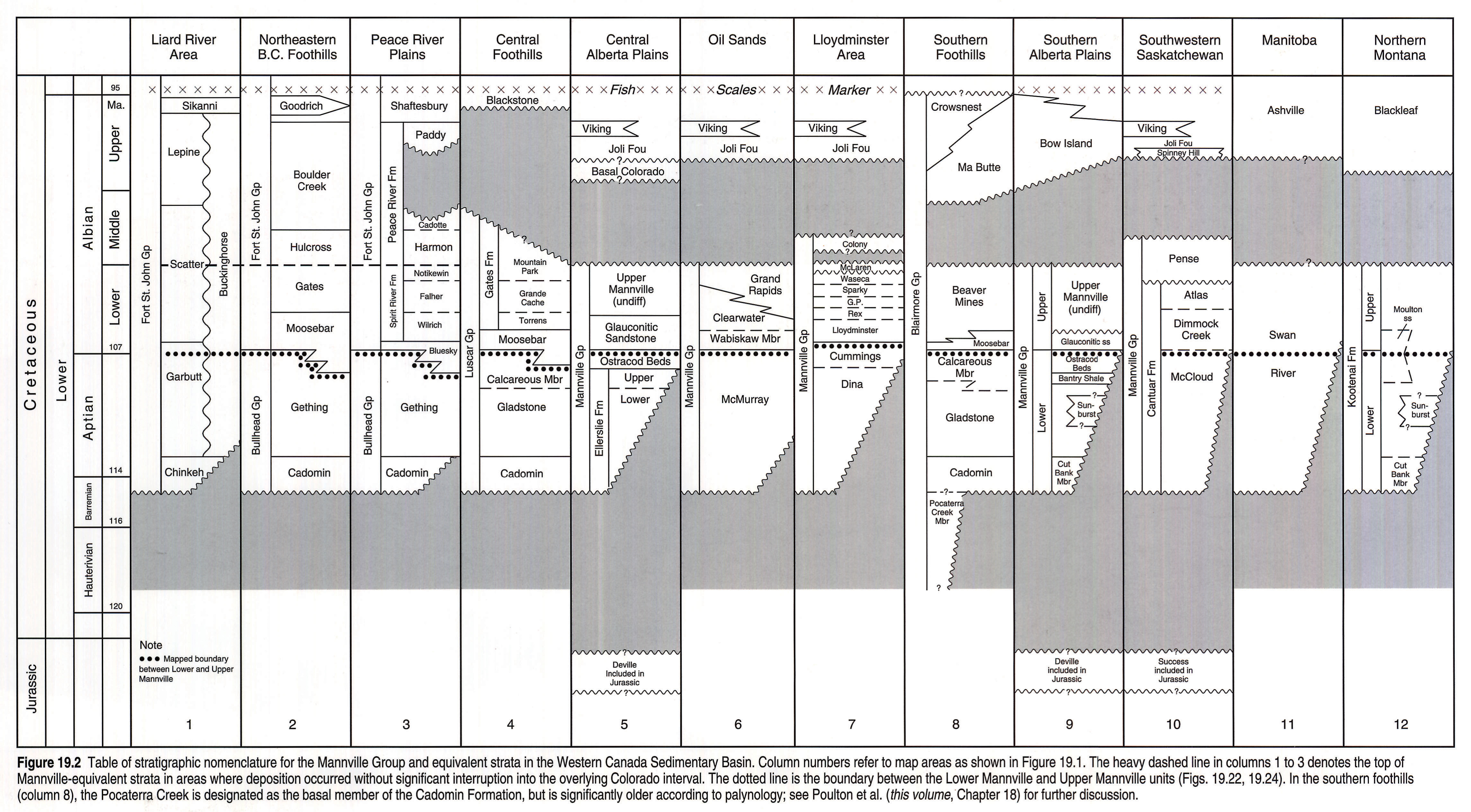
Mannville nomenclature is complex because the strata are geographically widespread and heterogeneous (Fig. 19.2). Everywhere, however, the Mannville lies on the sub-Mannville unconformity. In general, basal Mannville strata are continental, and hence poorly dated, but are generally accepted to be of Aptian age except in the southern foothills, where the Pocaterra Creek Member is pre-Aptian (see Poulton et al., this volume, Chapter 18 for discussion; Fig. 19.2). In the Alberta Plains, where the Mannville lies on Paleozoic carbonates, a highly-variable paleosol or regolith, termed the Deville Member or "detrital" zone, overlies the unconformity in some places (Williams, 1963). In the Saskatchewan Plains, Christopher (1974, 1984) included equivalent strata in the S2 member of the Success Formation, which also comprises thicker, more regionally extensive fluvial deposits made up of distinctive quartz-chert-siderite-kaolin sandstones and mudstones. Both the Deville and Success are considered to predate Mannville deposition, and consequently are mapped in the Atlas as Jurassic units (Poulton et al., this volume, Chapter 18). Some Deville/Success strata may be included in the regional Mannville isopach maps, however, because they can be difficult to distinguish on borehole logs.
An unconformity surface also bounds the top of the Mannville except in northwestern parts of the basin (Fig. 19.2, columns 1-3). This surface lies on top of the Cadotte Member in the Peace River area and at the top of the Cadotte equivalent within the Boulder Creek Formation of the northeastern British Columbia foothills. Strata of the Cadotte and Harmon members and their foothills equivalents should therefore logically be included in the Mannville interval. They are grouped with the Colorado interval in the Atlas because historically, the Cadotte Member has been mapped together with overlying strata as the Peace River Formation in the plains and the Boulder Creek Formation in the foothills.
Ammonites and microfossils in the Spirit River and Gates formations define the upper age limit of the Mannville in western areas (Stott, 1982). The age relations of unconformity-bounded units at the top of the Mannville to the east, such as the Colony Member and Pense Formation (Fig. 19.2), are unclear, because they have not been dated paleontologically. They appear to fit in with Upper Mannville paleogeographic patterns, however, and therefore are included in the Mannville.
Reference Logs
Reference logs from subsurface Mannville sections highlight nomenclatural complexities and lithological patterns across the basin (Fig. 19.5). The relations among these sections are presented in the discussions of regional paleogeographic maps and cross sections. A bold line indicates the division between Lower and Upper Mannville in all but the Liard River and Manitoba logs, and a dotted line marks the division in Figure 19.2. Glaister (1959), Williams (1963), Mellon (1967) and Christopher (1974) showed that the Lower/Upper Mannville boundary generally corresponds to an abrupt change in sandstone lithology from a quartz- and chert-rich suite below to a more volcanic and feldspathic composition above. Although more recent work (as discussed below) has shown this boundary to be more gradational than previously thought, a lower/upper subdivision based on lithology is still commonly used and can be applied over most of the basin.
Stratigraphic History and Paleogeography
The complex stratigraphy and paleogeography of the Mannville Group can be characterized in five discrete intervals, reviewed below from oldest to youngest. Each interval records a large number of events into a basin-wide overview, and each paleogeographic map represents a generalized snapshot of those events (see Smith, this volume, Chapter 17, for paleogeographic maps). Interval boundaries are diachronous in the absence of reliable basin-wide time lines. For example, brackish bay environments of the Ostracod/Calcareous interval are significantly younger in the south than in the north (Finger, 1983), but are grouped together on the same paleogeographic map.
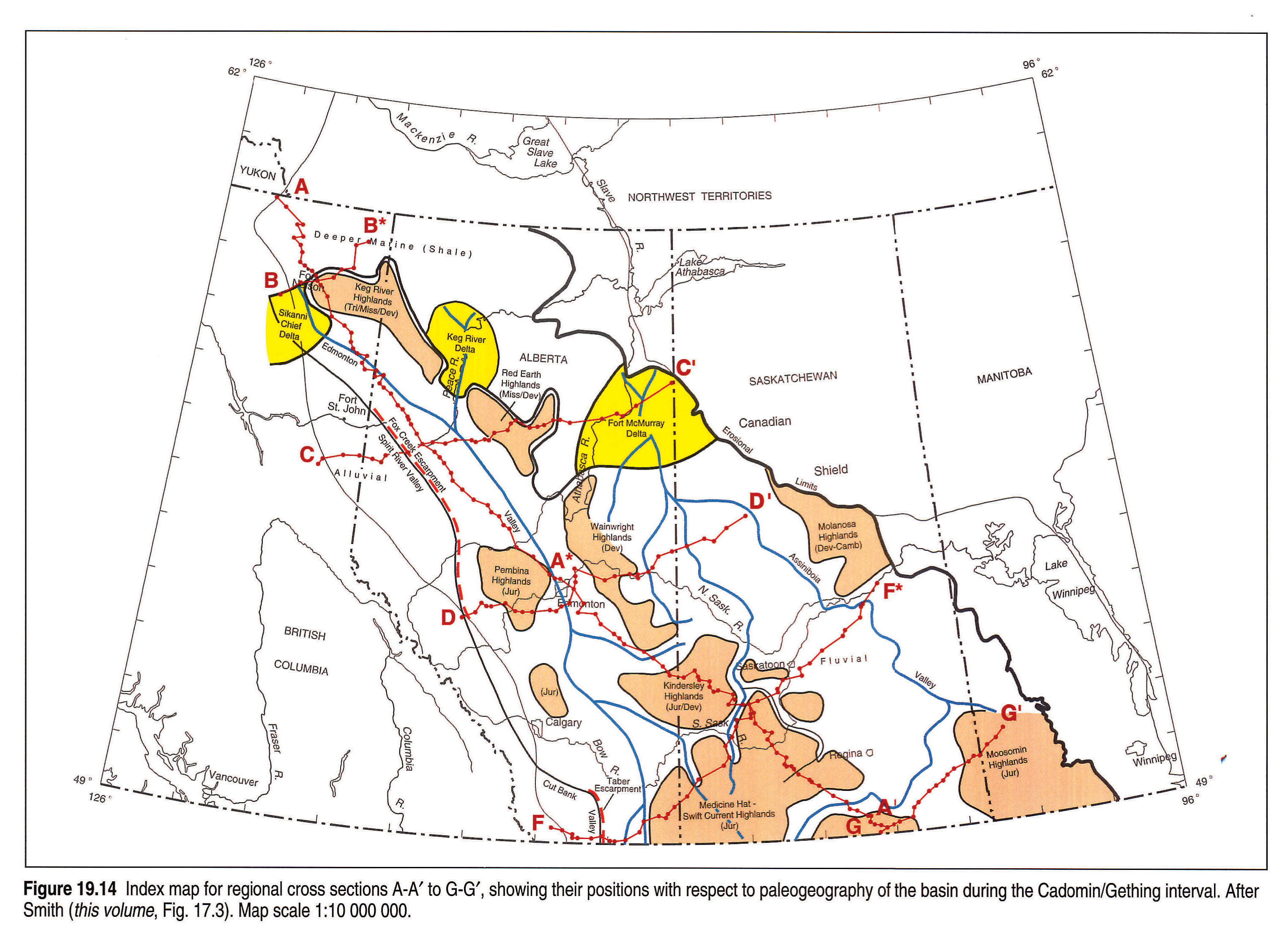
Cadomin/Gething Interval
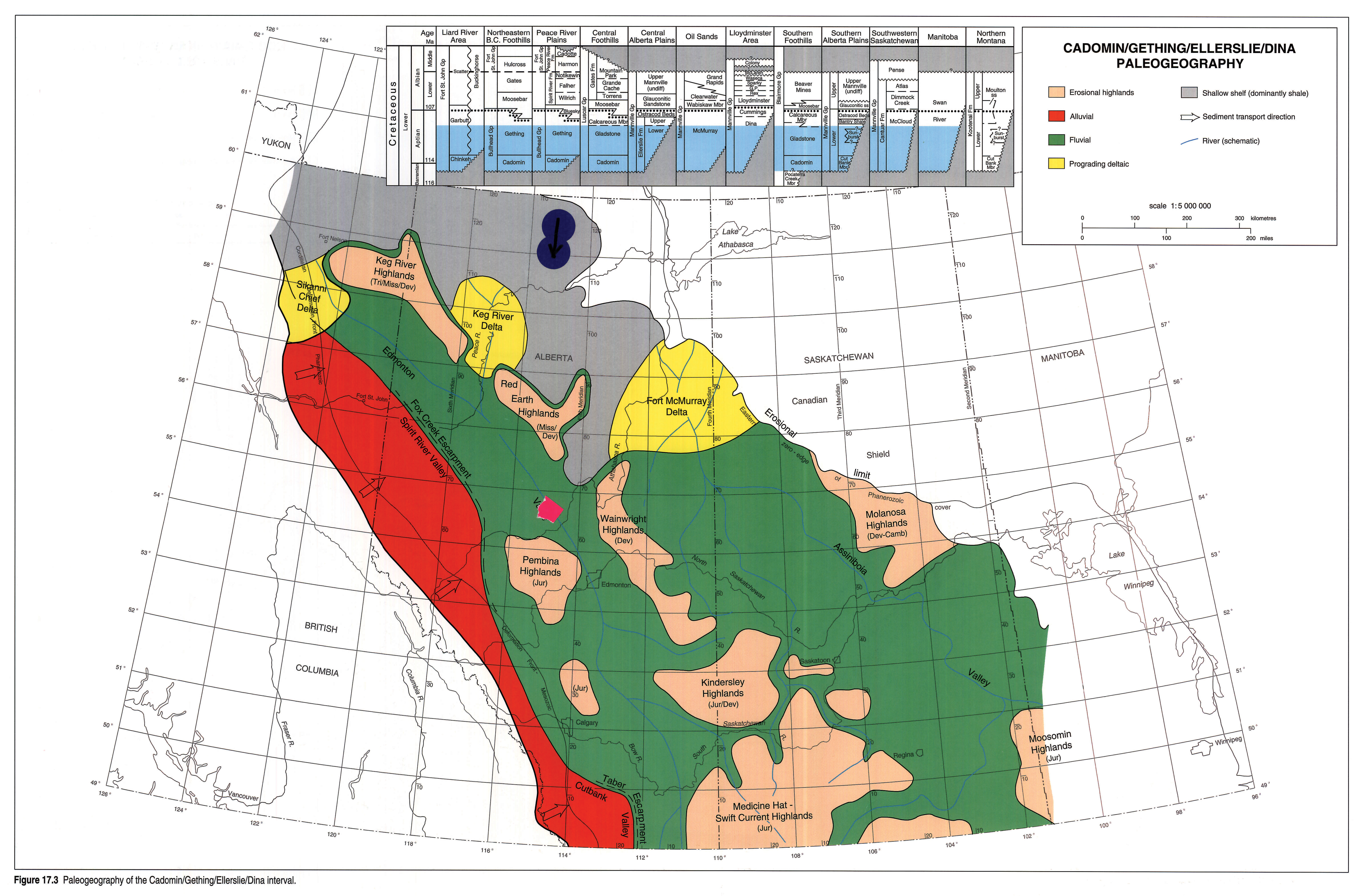
Figure 17.3 depicts Cadomin/Gething paleogeography and depositional environments. It represents strata of the Cadomin, Chinkeh and Cut Bank, as well as most of the Garbutt, Gething, Gladstone, Ellerslie, McMurray, Dina, McCloud and lower Mannville units, and the lower part of the Swan River Formation (Figs. 19.2, 19.5).
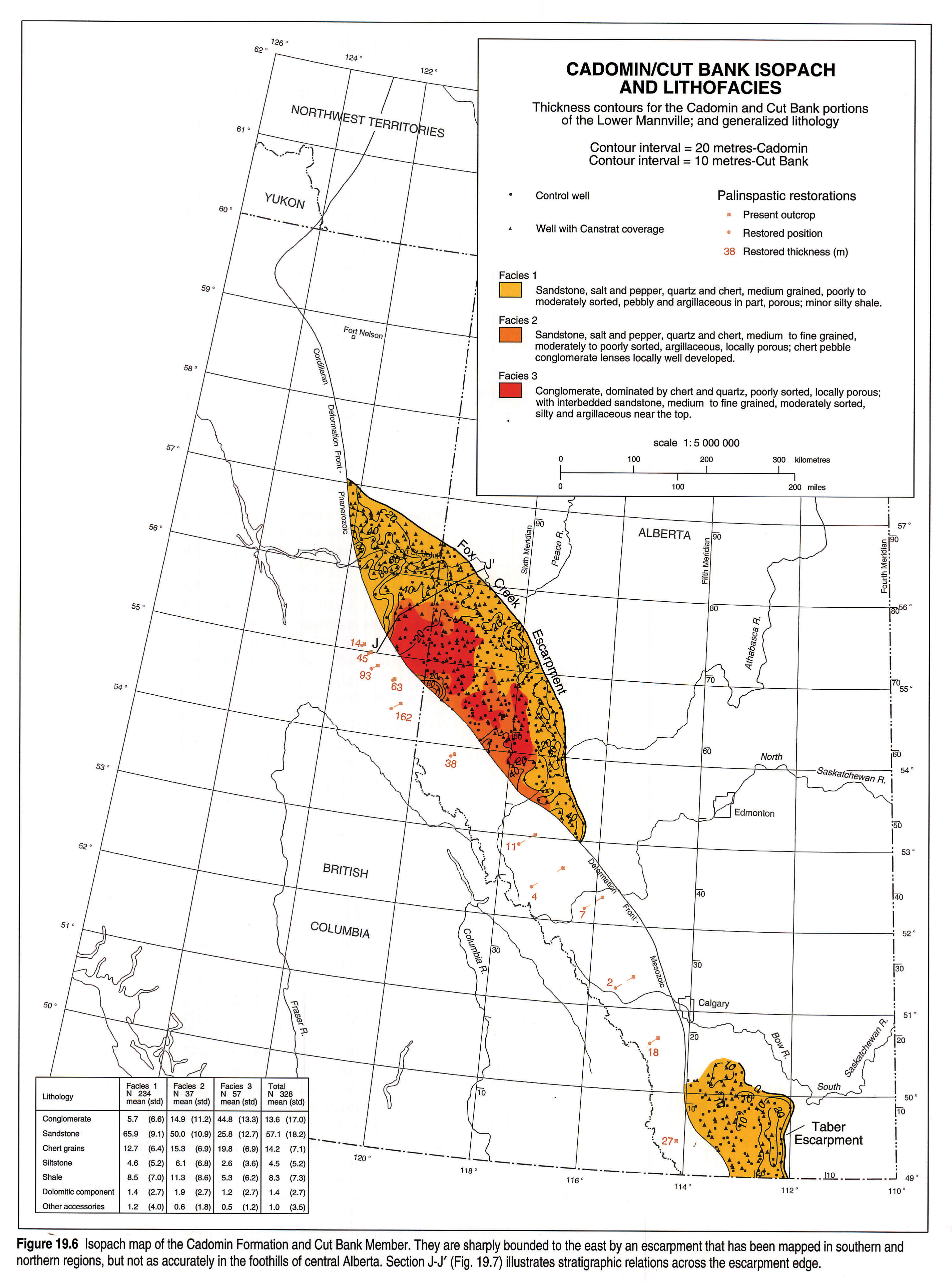
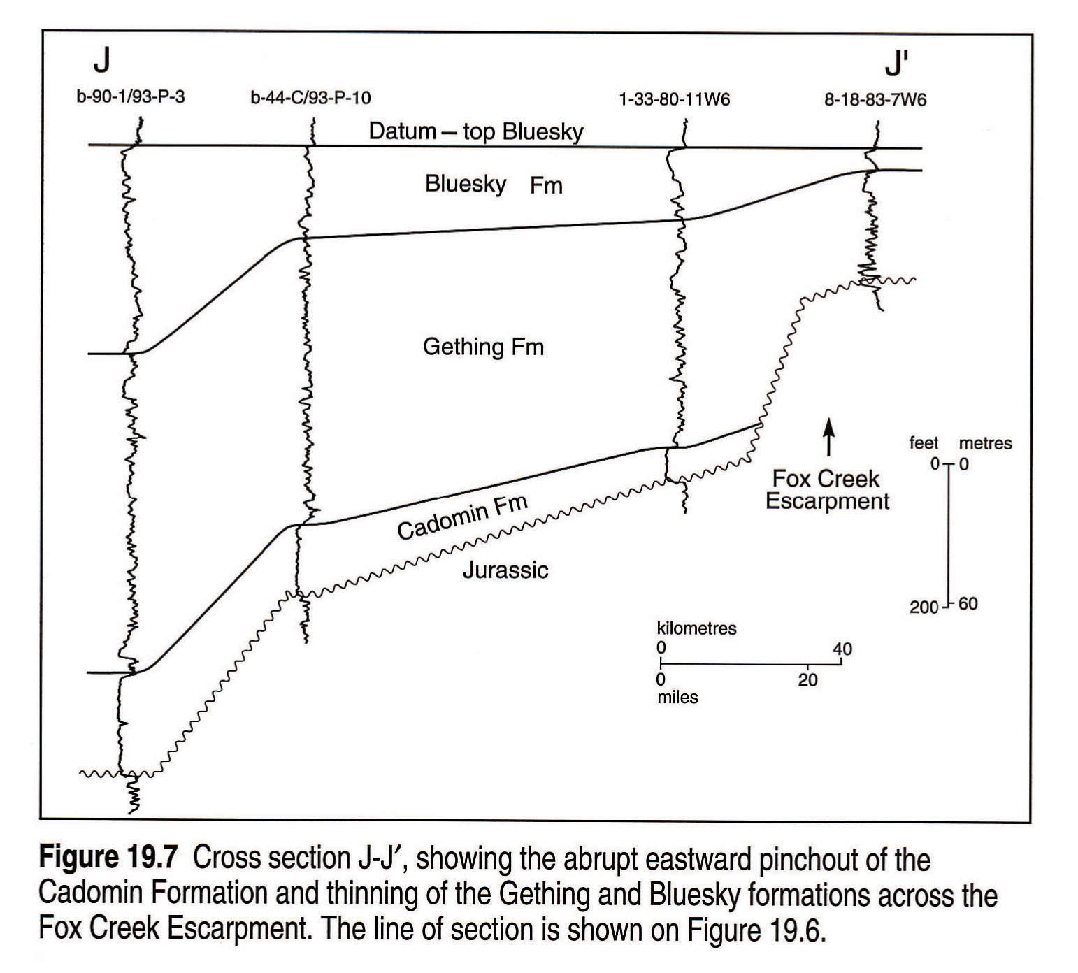
Along the western side of the basin, a belt of alluvial fans and pediment surfaces flanked the Cordilleran uplift (McLean, 1977). Rivers flowing from this belt fed the basin-axial Cut Bank-Spirit River valley system, which drained northward and was bounded to the east by the Fox Creek and Taber escarpments (Figs. 19.6, 19.7) (McLean, 1977; Hayes, 1986). Conglomerates and coarse sandstones of the Cadomin Formation and Cut Bank Member were laid down on the fans and pediments and in the Cut Bank-Spirit River valley system. As base level rose, great thicknesses of continental and deltaic sediments accumulated in the subsiding foredeep, particularly in the Gething Formation of the Peace River Arch area (Stott, 1973). Sandstones throughout the interval are rich in quartz and chert and poor in igneous detritus, indicating derivation from older, upthrust sedimentary rocks in the Cordilleran source area (Mellon, 1967), or distant source areas in the United States (Christopher, 1974).
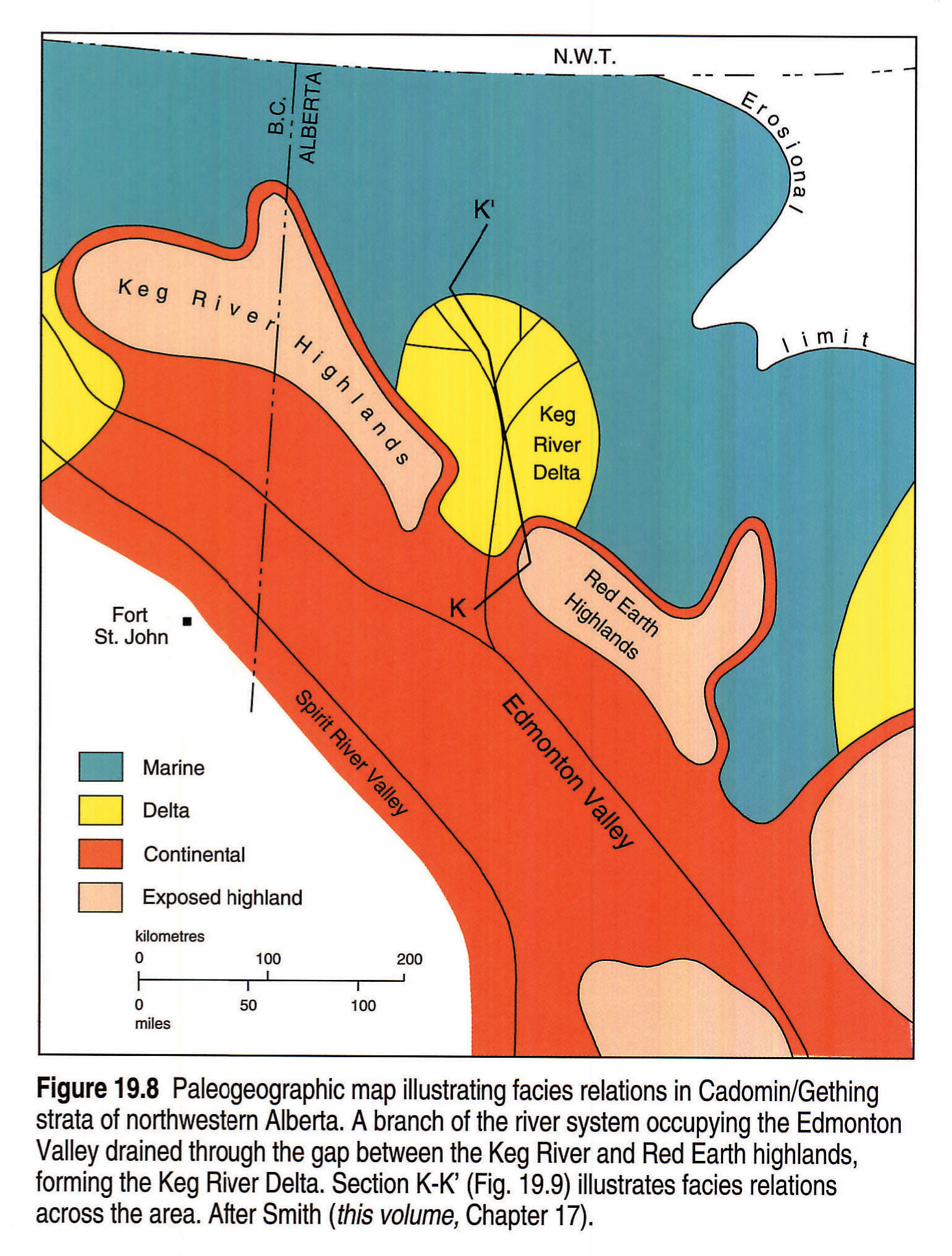
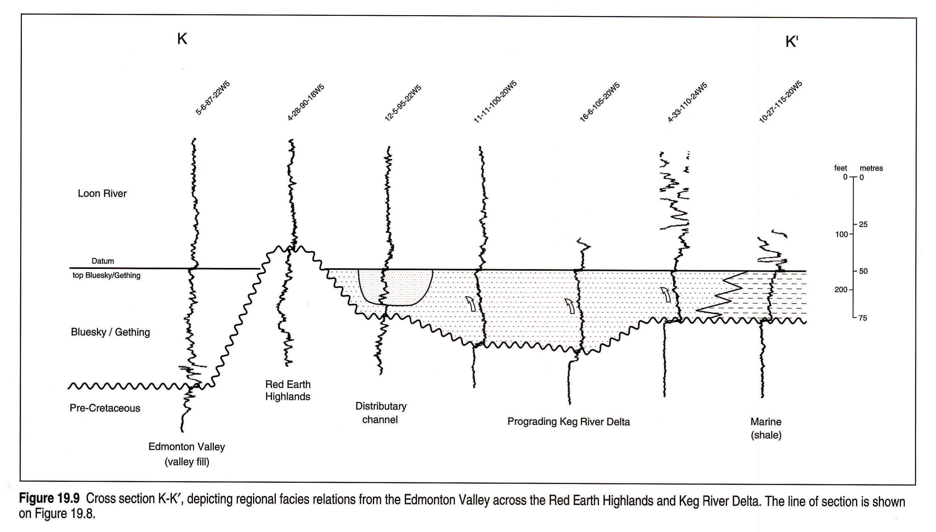
To the east, northward-flowing rivers occupying a network of incised valley systems, including the Edmonton and Assiniboia valleys, drained the remainder of the foreland basin and emptied into the northern sea (Jackson, 1984; Christopher, 1984; Putnam, 1989). Fluvial Gething, Gladstone, Ellerslie, Dina, McCloud and associated lower Mannville strata accumulated within the valleys, while the intervening highlands remained emergent. Banerjee and Davies (1988) interpreted much of the Ellerslie fill of the Edmonton Valley to have been deposited under brackish water conditions. Three major deltaic complexes, the Sikanni Chief (Gething Formation), Keg River (Bluesky-Gething), and Fort McMurray (McMurray Formation) formed where the major rivers reached the sea (Stott, 1973; Flach, 1984). The Precambrian Shield supplied quartzose sediments to the eastern valley systems and the Fort McMurray deltaic complex (Harrison et al., 1981). Figures 19.8 and 19.9 illustrate facies relations across the Keg River delta complex.
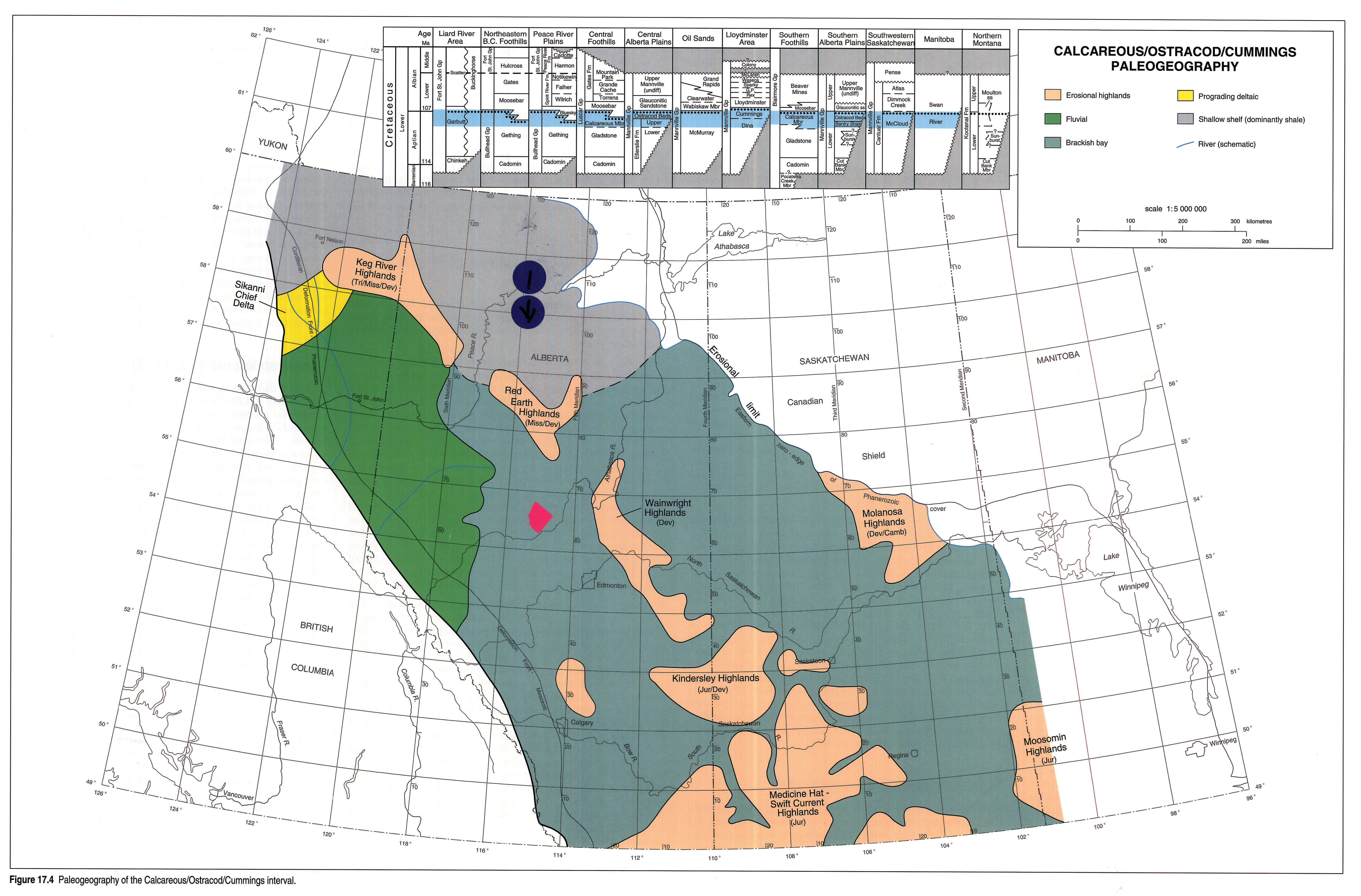
Calcareous/Ostracod Interval
Figure 17.4 illustrates Calcareous/Ostracod depositional environments and paleogeography. Strata deposited during this interval include: the Ostracod beds and the Calcareous and Cummings members, as well as the upper parts of the Gething, Ellerslie, McMurray, Dina and McCloud units, and the basal part of the Moosebar Formation (Figs. 19.2, 19.5).
Dark calcareous shales, siltstones and lenticular sandstones associated in thin coarsening-upward successions characterize the interval throughout the plains and southern and central foothills. The sandstones are generally siliceous, as in the underlying Cadomin/Gething interval. Thin micritic limestone beds and pelecypod/gastropod/ostracod coquinas also are common (Glaister, 1959; Williams, 1963; Mellon, 1967; Christopher, 1974).
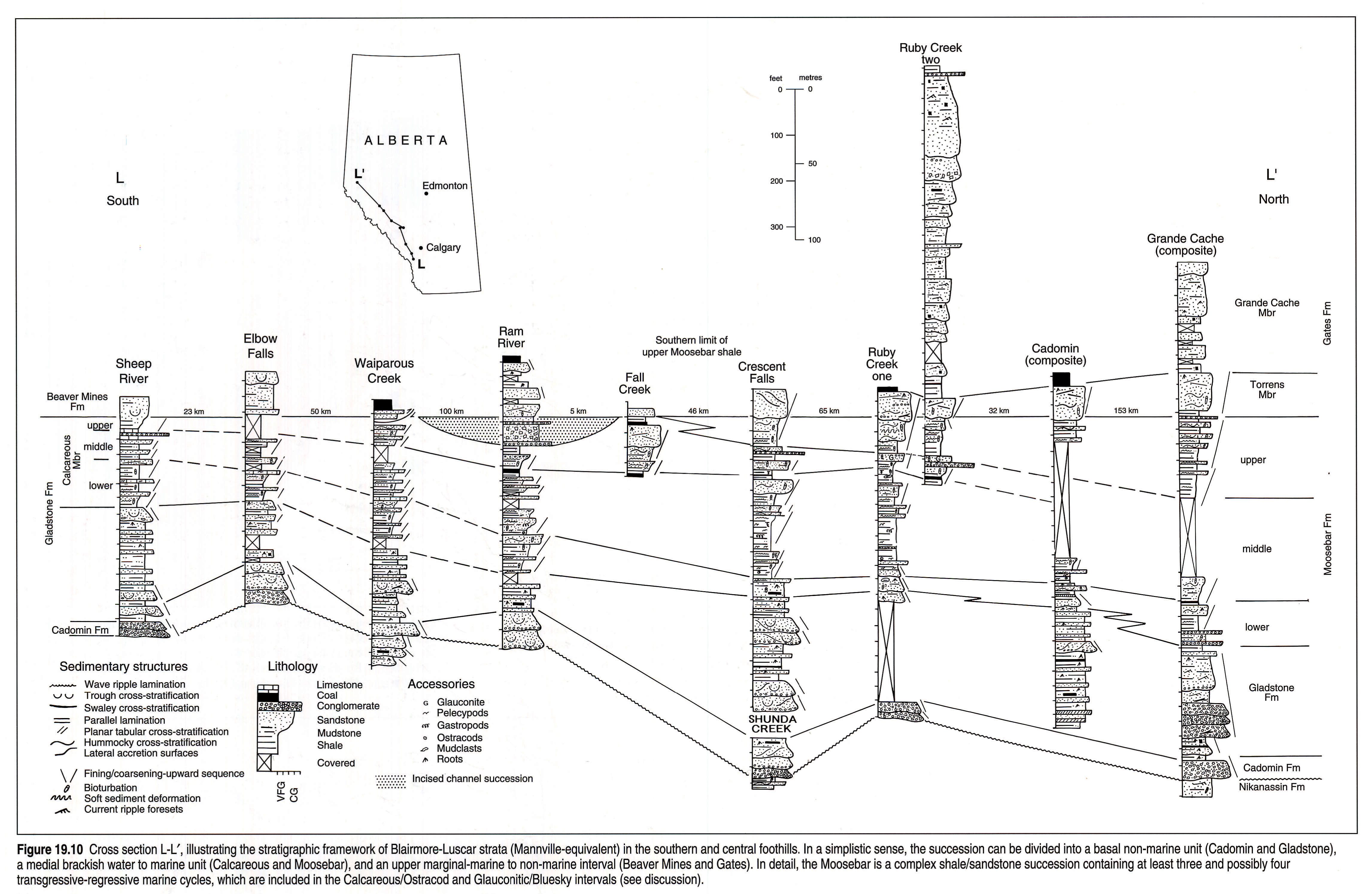
Deposition of Calcareous/Ostracod strata was associated with the early stages of transgression of the Moosebar/Clearwater Sea from the north. Brackish bays advanced southward along the Spirit River, Edmonton, and Assiniboia valley systems, but the major highlands remained emergent (Christopher, 1974; McLean and Wall, 1981). Ostracod/Calcareous strata are generally younger and more continentally influenced to the south (Fig. 19.10; Finger, 1983). Tides had a significant effect on sedimentation within the brackish bay setting (Wanklyn, 1985; Banerjee and Davies, 1988). Precise stratigraphic correlations and environmental interpretations are controversial, but have been addressed by detailed sedimentological and paleontological studies, such as James (1985), Wanklyn (1985), and Banerjee and Davies (1988). Figures 19.10 and 19.11 illustrate some of these correlations and interpretations and are reviewed in more detail in the discussion section at the end of this chapter.
In the Peace River Arch area, fluvial/deltaic deposition of the Gething Formation continued as the influx of Cordilleran-derived sediments kept pace with rising base level. Tongues of marine strata within the upper Gething on the north flank of the Arch in British Columbia are considered to be slightly younger than the Ostracod beds (Duff and Gilchrist, 1981). In Figure 19.10, similar marine tongues at the top of the Gladstone Formation on the south flank of the Peace River Arch are mapped as the lower to middle Moosebar Formation.
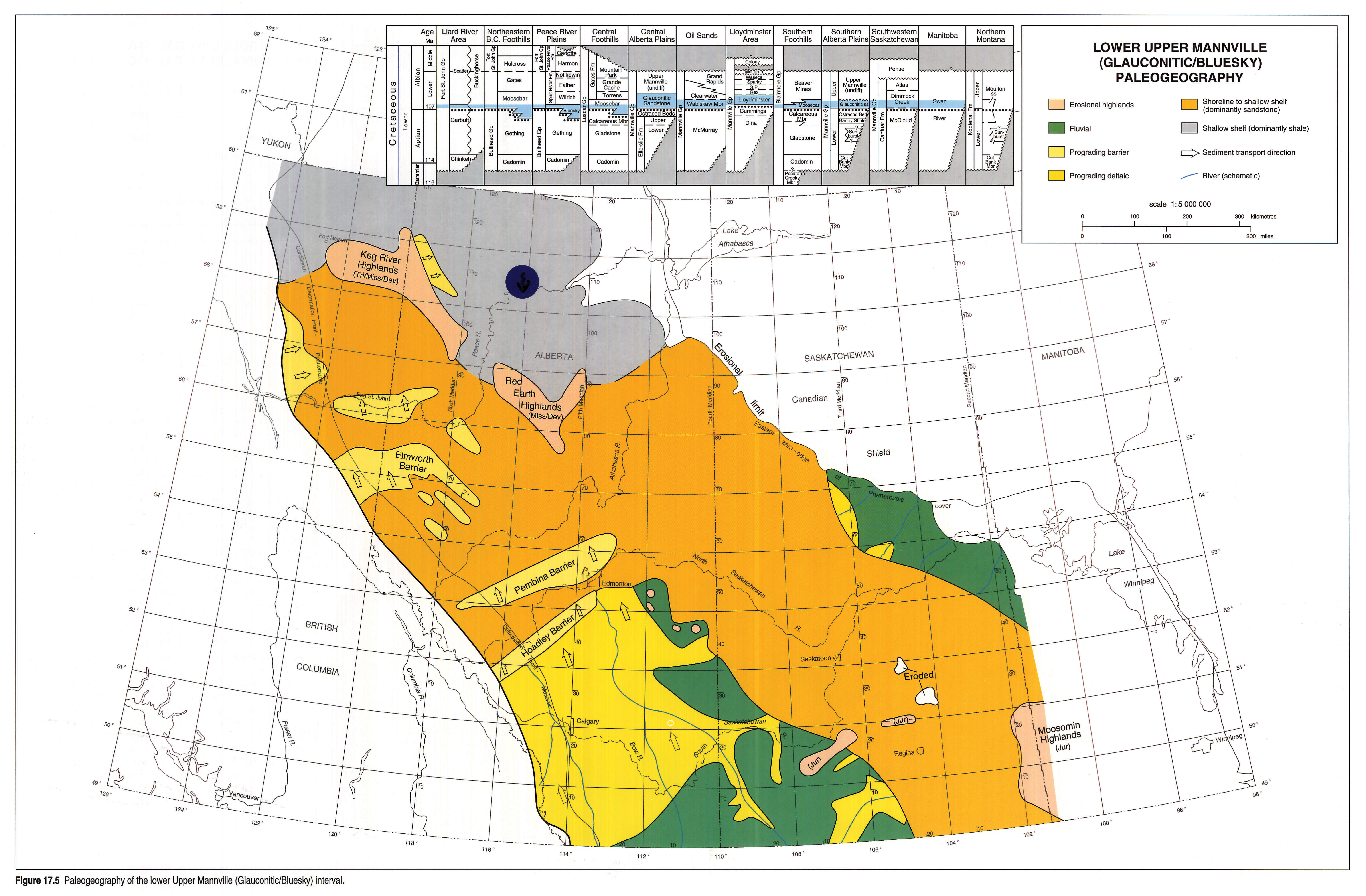
Lower Upper Mannville (Glauconitic/Bluesky) Interval
Figure 17.5 illustrates Glauconitic/Bluesky depositional environments and paleogeography. Strata included in this interval are: the Glauconitic, Bluesky, Wabiskaw and Lloydminster, as well as the lower parts of the Moosebar, Clearwater and Dimmock Creek units (Figs. 19.2, 19.5).
Glauconitic/Bluesky strata record the maximum transgression and subsequent early regressive stages of the boreal Moosebar/Clearwater Sea in the southern and central parts of the basin. Sandstones of the interval contain elements of both the underlying siliceous suite and the overlying volcanic-feldspathic suite. In the southern plains, fluvial aggradation began over the Medicine Hat-Swift Current, Kindersley and Wainwright highlands as base level continued to rise. Intervening Calcareous/Ostracod embayments were filled by a flood of coarse clastic detritus from the Cordillera, which was deposited in thin, repetitive, coarsening-upward marine shale/sandstone successions, locally dissected by incised valleys filled with fluvial and estuarine facies. Fluvial and deltaic facies cap the interval (Wood and Hopkins, 1989; Rosenthal, 1988). The northern limit of continental to marginal-marine facies is marked by a complex of progradational marine sandstone bodies, including the Pembina and Hoadley barriers (Rosenthal, 1988). A similar pattern is evident in southwestern Saskatchewan, where fluvial to deltaic facies of the Dimmock Creek Member filled flooded valleys and graded northward into marine sandstones of the Lloydminster Member (Christopher, 1984). To the northeast, fluvial sediments derived from the Canadian Shield were deposited on the Molanosa Highlands.
Open-marine conditions prevailed in more northern areas, as recorded by shallow-shelf deposits of the Clearwater Formation in northeastern Alberta and Saskatchewan (Kramers, 1974; Harrison et al., 1981; Christopher, 1984) and open-marine strata of the Moosebar Formation and Wilrich Member toward the western foredeep (McLean and Wall, 1981). The Wabiskaw and Bluesky are sand-rich units deposited at the base of this marine succession in a variety of transgressive and regressive environments. They are most extensively developed over the Fort McMurray Delta and the Gething Delta complex, and on the flanks of the still-emergent Keg River and Red Earth highlands (Smith et al., 1984; O'Connell, 1988; Ranger et al., 1988).
Recent work has demonstrated that the Moosebar/Clearwater transgression was highly episodic. Several small-scale transgressive and regressive events took place in widely separated areas such as southern Alberta (James, 1985; Wood and Hopkins, 1989), the central Alberta marine sandstone complex (Rosenthal, 1988), Lloydminster (Putnam, 1982), and the Peace River Arch area (O'Connell, 1988). Interfingering of Lower Mannville quartz-chert sandstones with Upper Mannville volcanic-feldspathic sandstones indicates that Cordilleran tectonic events may have altered the sediment supply to the basin, and hence exerted some control on relative sea level (James, 1985; Rosenthal, 1988). Inter-regional correlation of these small-scale events is considered in more detail in the discussion at the end of this chapter, and in Figures 19.10 and 19.11.
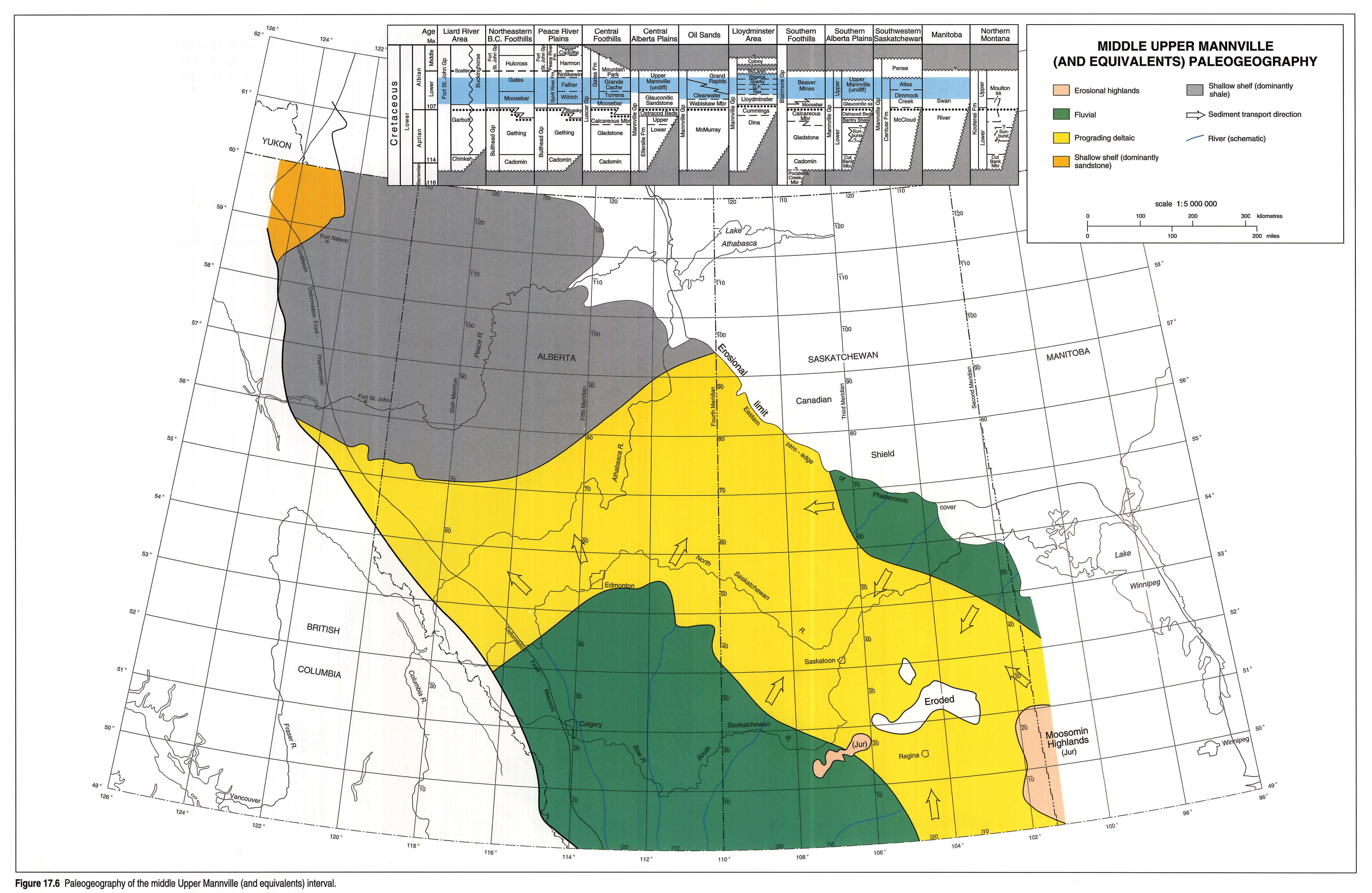
Middle Upper Mannville Interval
Figure 17.6 illustrates depositional environments and paleogeography of the middle Upper Mannville interval, which includes the upper Garbutt Formation and lower (Bulwell) sandstone of the Scatter Formation; the Falher, Grande Cache and Torrens members, along with the upper part of the Moosebar Formation and Wilrich Member; the upper Clearwater and lower Grand Rapids formations; the Rex through Waseca members; the upper Dimmock Creek Member and the entire Atlas Member; and the lower parts of the undifferentiated Upper Mannville, Gates and Beaver Mines formations (Figs. 19.2, 19.5). Sandstones in this interval contain significant volcanic and feldspathic components, indicative of Cordilleran tectonic events that exposed volcanic and metamorphic source areas (Mellon, 1967).
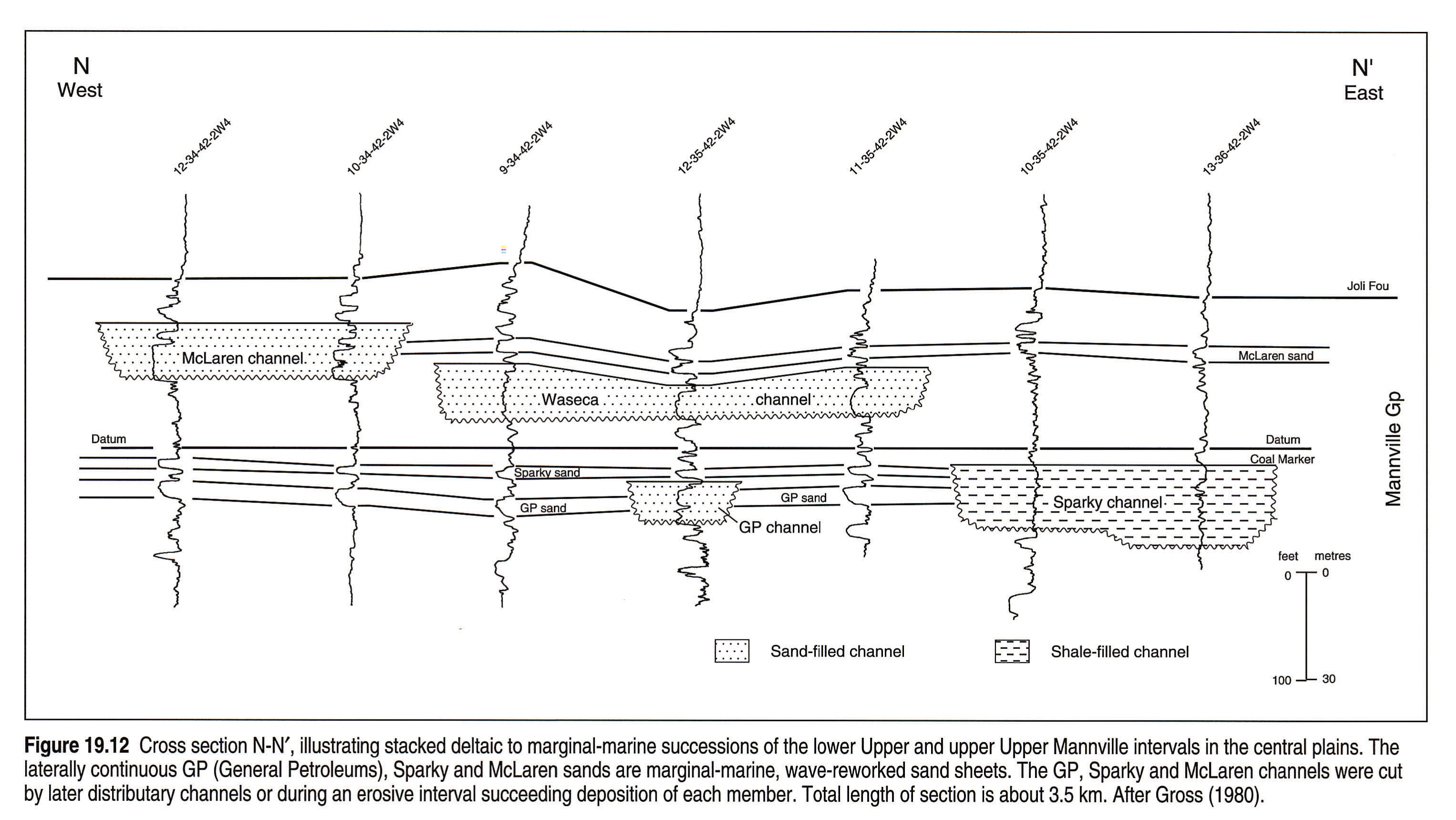
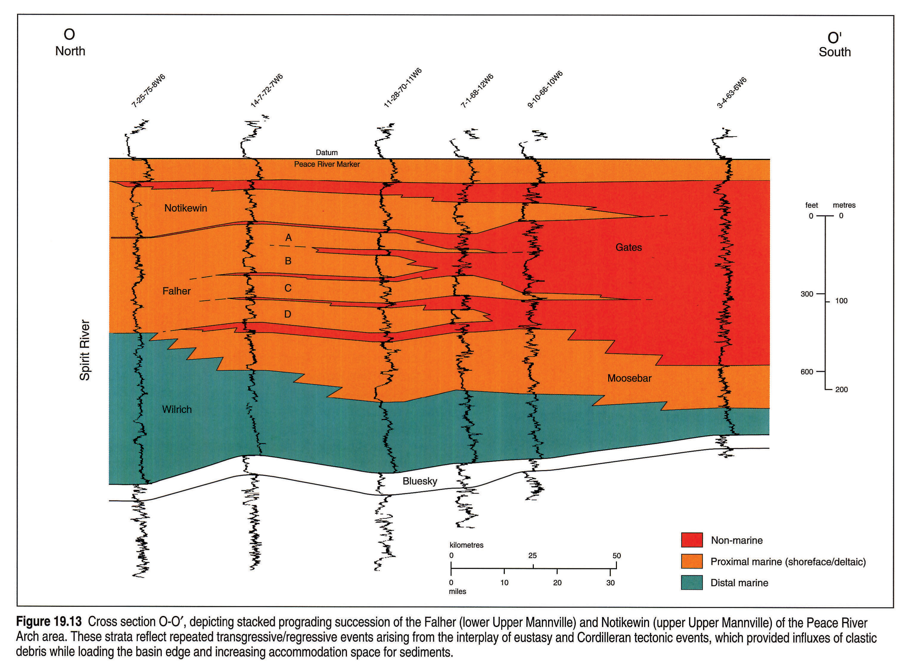
Episodic regression of the Moosebar/Clearwater Sea continued after lower Upper Mannville (Glauconitic/Bluesky) deposition. Across the south, fluvial sedimentation is recorded in thick sandstone, siltstone and shale sequences of the foothills (Mellon, 1967), and in repetitive valley incision and aggradation events in the plains (Christopher, 1974, 1984; James, 1985; Hayes, 1986; Wood and Hopkins, 1989; Fig. 19.12). The fluvial regime graded northward into a broad apron of stacked deltaic successions and wave-influenced shorelines across the central Alberta and Saskatchewan plains (Mellon, 1967; Kramers, 1974; Gross, 1980; Harrison et al., 1981; Putnam, 1982; Christopher, 1984; Fig. 17.6). In the extreme northeast, over the former Molanosa Highlands, fluvial quartzose sands derived from the Precambrian Shield continued to accumulate (Christopher, 1984). Thicker stacked prograding successions in the Peace River Arch and foothills areas were reworked along their northern marine margins into continuous high-energy shoreface and beach sandstones and conglomerates (Cant, 1984; Smith et al., 1984; Leckie, 1986, Macdonald et al., 1988; Fig. 19.13).
In the far north, fossiliferous dark shales of the Garbutt, Buckinghorse and Loon River formations record open-marine conditions (Mellon, 1967; Stott, 1982). Shallow-marine sandstone deposits in the Liard Basin are correlated with the middle Upper Mannville interval by ammonites (Stott, 1982).
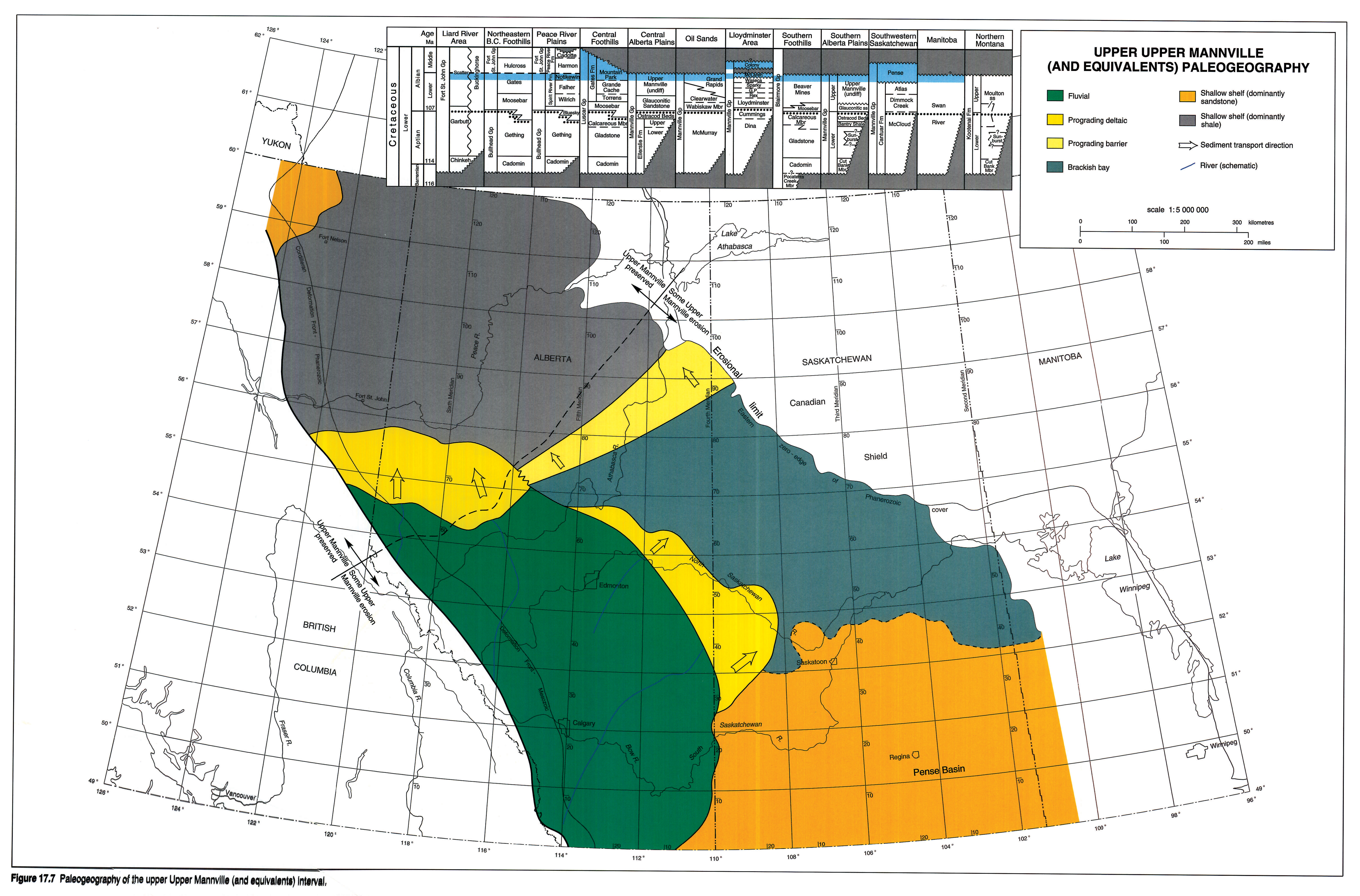
Upper Upper Mannville Interval
Figure 17.7 depicts the paleogeography and depositional environments of the upper Upper Mannville interval, which includes the entire Notikewin, Mountain Park, McLaren, Colony and Pense units; the uppermost portions of the Grand Rapids, undifferentiated Gates, Upper Mannville, Beaver Mines and Swan River formations; and the uppermost Bulwell Member of the Scatter Formation (Figs. 19.2, 19.5). Uppermost Mannville sandstones contain the same volcanic-feldspathic mineral suite as the underlying interval in the western part of the basin, but are highly quartzose in Saskatchewan and Manitoba.
Fluvial aggradation continued unchanged from the middle Upper Mannville across southern and central Alberta. The two intervals cannot be distinguished except in the central foothills, where the Mountain Park Member lacks the thick coal seams of the underlying Grande Cache Member (McLean, 1982). In the foothills and plains of Peace River, the progradational Notikewin Member was deposited in moderate-energy barrier island and deltaic environments, in contrast to the underlying high-energy Falher shorelines (Smith et al., 1984; Leckie, 1985; Fig. 19.13). Brackish waters transgressed the shallow Pense Basin of Saskatchewan, which then was filled with four, thin, coarsening-upward shoreface successions of the Pense Formation (Christopher, 1974). Much of the upper Swan River Formation in Manitoba comprises restricted-marine facies (McNeil, 1984), and is probably equivalent to the Pense Formation. Deltaic facies of the McLaren and Colony members form the transition between the fluvial and brackish regimes in the Lloydminster area. Some McLaren channels cut into underlying units (Fig. 19.12) and may represent incision and fill events associated with minor relative sea-level fluctuations. To the north, the upper Grand Rapids prograding barrier may have sheltered the Pense Basin from the Boreal Sea, where marine fine clastic deposition continued.
Regional Cross Sections
Six cross sections spanning the entire Western Canada Sedimentary Basin illustrate the stratigraphic relations discussed above. Figure 19.14 shows the lines of section overlain on the Cadomin/Gething paleogeography of Figure 17.3, in order to relate them to specific paleogeographic features.
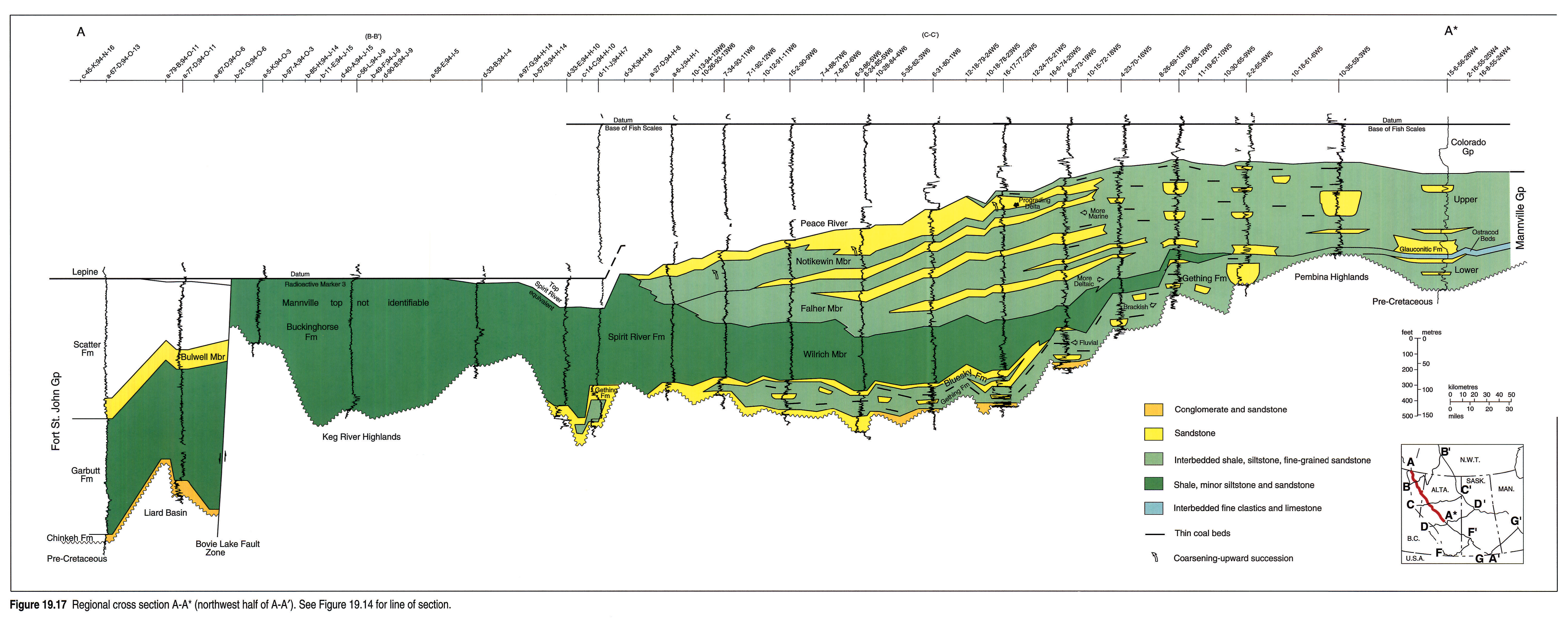
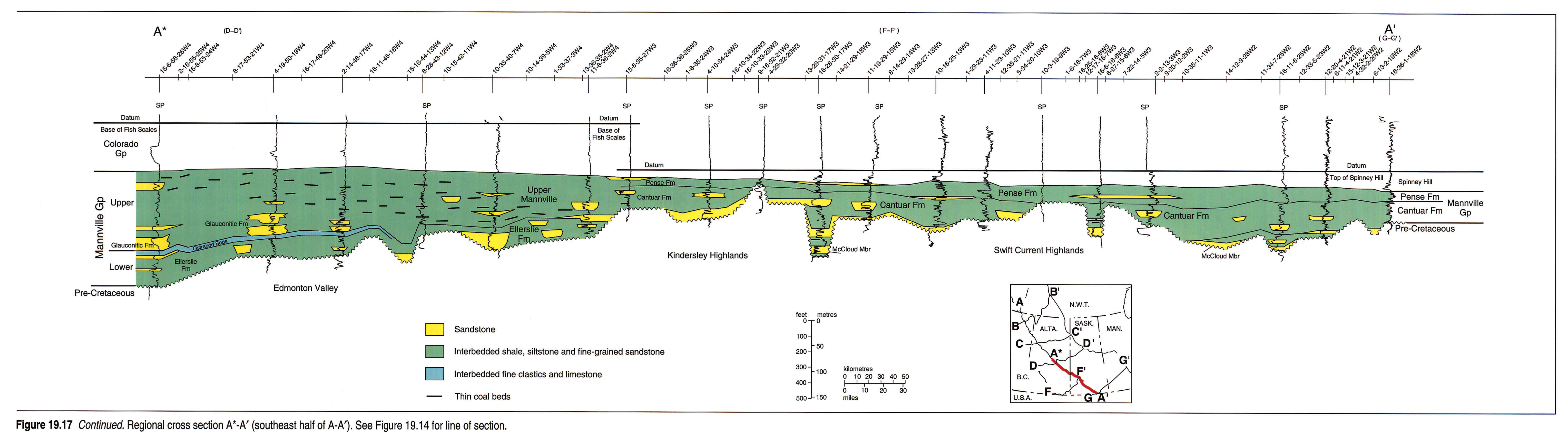
Section A-A'
Section A-A' (Fig. 19.17 left pane and 19.17 right pane) spans the entire Western Canada Sedimentary Basin, from the Liard Basin in the northwest to the Swift Current Highlands in southern Saskatchewan. The five northern wells in the Liard Basin penetrate a thick section including coarse clastics of the basal Chinkeh (Cadomin/Gething interval), Garbutt shales (Ostracod/Calcareous and Glauconitic/Bluesky) and Bulwell sandstones (middle Upper and upper Upper Mannville). South of the Bovie Fault Zone, the Keg River Highlands are covered by thinner Buckinghorse shales (middle Upper and upper Upper Mannville, and post-Mannville).
The Mannville section thickens toward the Peace River Arch area, where coarser continental and shallow-marine clastics that prograded from the west and south dominate. Open-marine shales of the Wilrich Member (Glauconitic/Bluesky) pinch out over the Pembina Highlands, to be replaced by the brackish Ostracod beds and the Glauconitic shallow-marine sandstone complex across the Edmonton Valley. Along the remainder of A-A', the Mannville is thin across the Kindersley and Swift Current highlands, except where it fills valleys on the sub-Mannville unconformity surface.
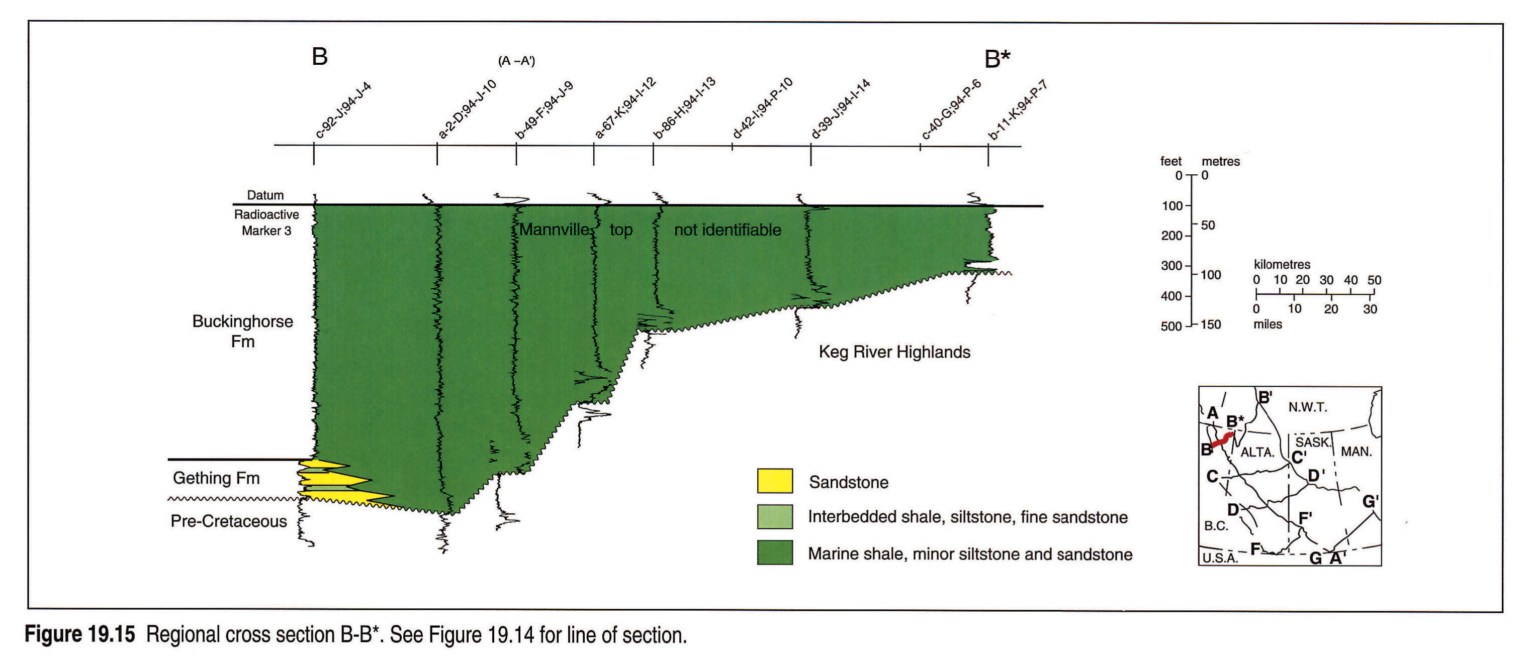
Section B-B*
The westernmost well of B-B* (Fig. 19.15) penetrates the distal edge of the Sikanni Chief Delta (Cadomin/Gething interval). Farther east, Buckinghorse shales lap onto the Keg River Highlands and crop out in wooded swamps of northernmost British Columbia and Alberta (Stott, 1982).
Section C-C'
Section C-C' (Fig. 19.16) follows the trend of the Peace River Arch from the foothills to the oil sands. The western wells penetrate the thickest Mannville sections of the basin, where the Peace River Arch and foredeep depocentres converge. Each depositional interval is fully developed: the Cadomin/Gething alluvial fan and deltaic complex (extending through the Calcareous/Ostracod interval); shallow-marine Bluesky progradational facies within the overall Glauconitic/Bluesky transgression, capped by open-marine Wilrich shales; stacked prograding Falher shorelines (middle Upper Mannville), and prograding Notikewin barrier island and deltaic facies (upper Upper Mannville).
Northeastward, the Gething and Bluesky formations lap onto the Red Earth Highlands and the Spirit River Formation grades into undifferentiated, fine-grained marine clastics of the Loon River Formation. At its eastern end, the section intersects the Fort McMurray Delta of the McMurray Formation (Cadomin/Gething and Calcareous/Ostracod intervals), which is overlain by transgressive Wabiskaw sandstones (Glauconitic/Bluesky). Fine-grained marine clastics of the Clearwater Formation grade up into the Grand Rapids stacked prograding barrier deposits of the middle Upper and upper Upper Mannville intervals.
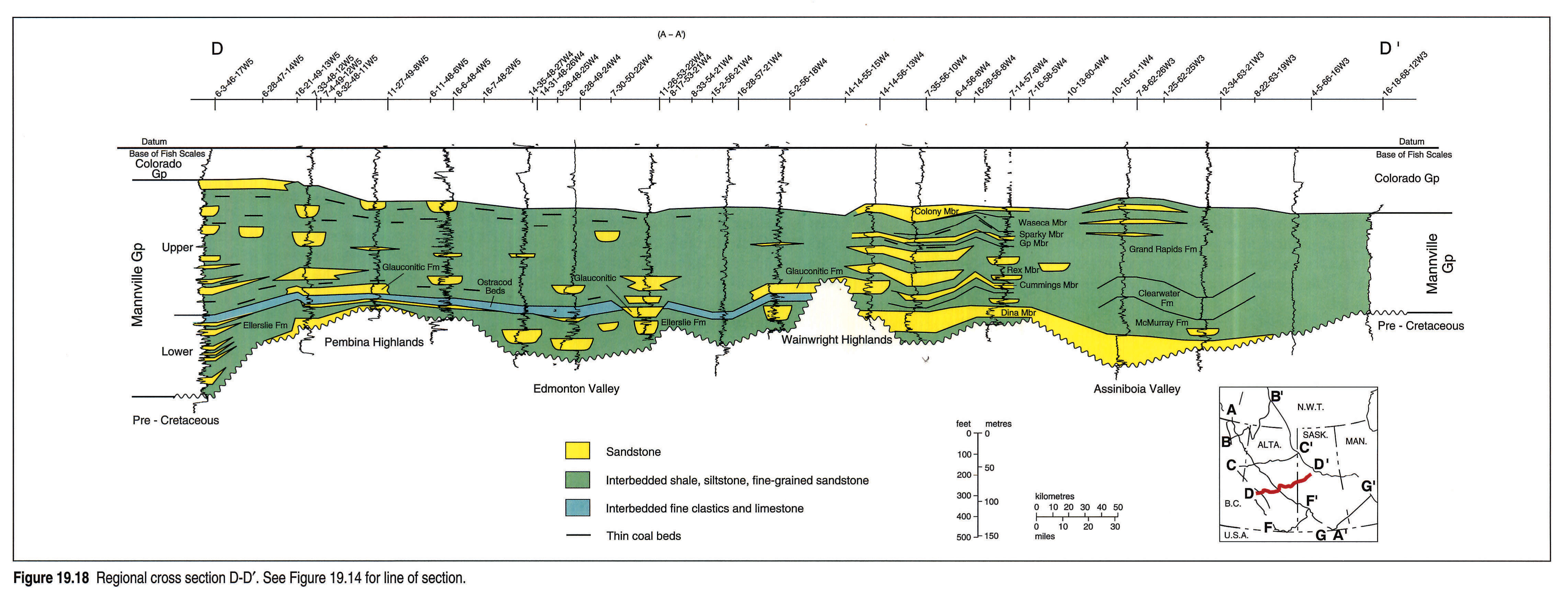
Section D-D'
Section D-D' (Fig. 19.18) parallels C-C' but lies south of the Gething delta complex and the Upper Mannville marine and shoreline facies. Thus, in the western half of D-D', a dominantly fine-grained continental section is interrupted only by the brackish Ostracod beds and the shallow-marine deposits of the Glauconitic Sandstone. Coarsening-upward sandstones of the Pembina Barrier are well developed from 16-21-49-13W5 to 11-27-49-8W5, and a Glauconitic incised valley associated with a minor relative sea-level fall is shown in 11-26-53-22W4.
East of the Wainwright Highlands, in the Lloydminster area, stacked continental to marginal-marine facies dominate the entire Mannville section. In the Assiniboia Valley, the McMurray, Clearwater and Grand Rapids formations are difficult to differentiate because they are dominated by brackish-water, low-energy facies south of the Fort McMurray Delta and the Grand Rapids barrier system.
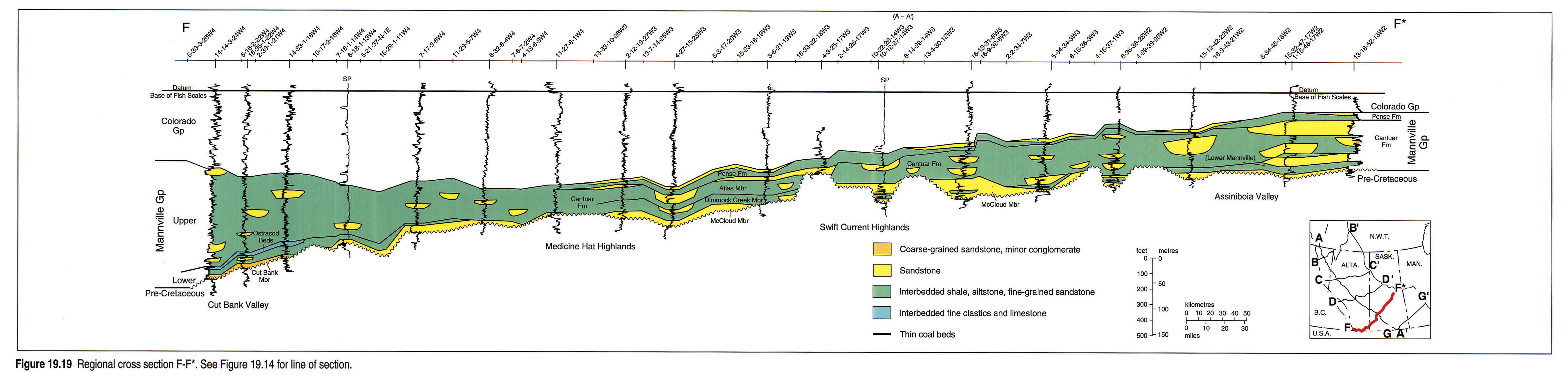
Section F-F*
Parallelling C-C' and D-D' in the southern part of the basin, F-F* (Fig. 19.19) traverses thin Mannville sections dominated by continental facies. In the Cut Bank Valley at the western end of the section, the Cut Bank Member represents the eastern limit of lower Cadomin/Gething alluvial fans and braidplains. Brackish-water facies of the Ostracod beds cap the Lower Mannville fill of the Cut Bank Valley, and lap out against the highlands to the east.
The Pense Formation is well developed from the Alberta border eastward, but its coarsening-upward components cannot be resolved at this scale. At the eastern end of the section, sandy fluvial facies lie near the Molanosa Highlands and Precambrian Shield source area.
Section G-G'
At the southeastern end of the basin, G-G' (Fig. 19.20) traverses Mannville sections that are entirely continental except for the Pense Formation. The apex of the Moosomin Highlands (6-19-13-32W1) was not covered until Pense deposition, thus hindering correlation of the eastern Swan River Formation with the rest of the Mannville.
Regional Maps
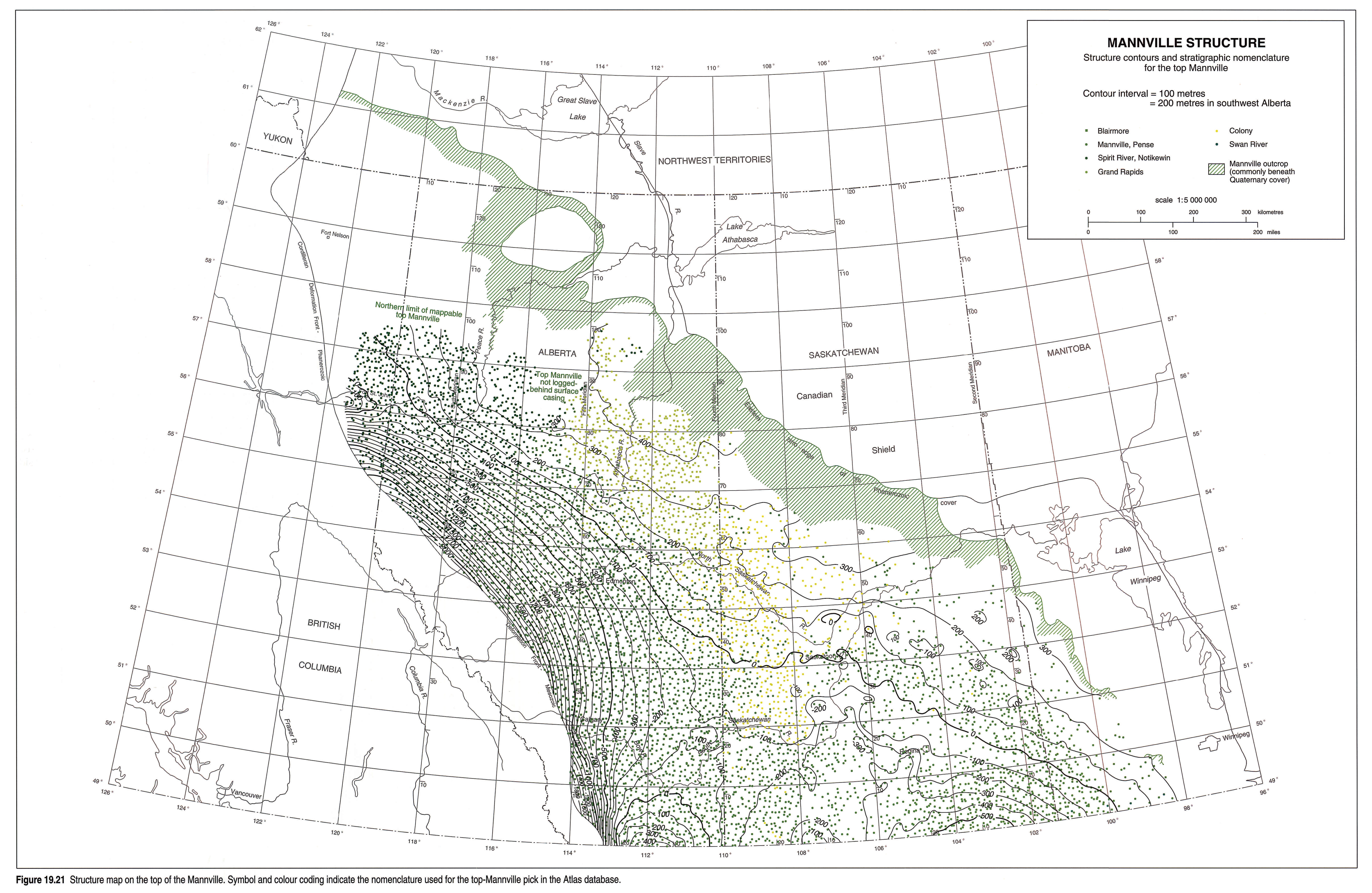
Mannville Structure
The present-day structure of the top-Mannville surface reflects some of the tectonic elements that controlled Mannville deposition (Fig. 19.21). Over most of Alberta the surface dips southwestward, the dip angle steepening toward the foredeep. The Mannville depocentre over the Peace River Arch however, is now a marked positive feature. In Saskatchewan, the Mannville surface dips southward into the Williston Basin; local anomalies are the products of post-Mannville dissolution of Devonian salts (Christopher, 1984). The Sweetgrass Arch trends northeastward from southern Alberta, separating the two regional basins.
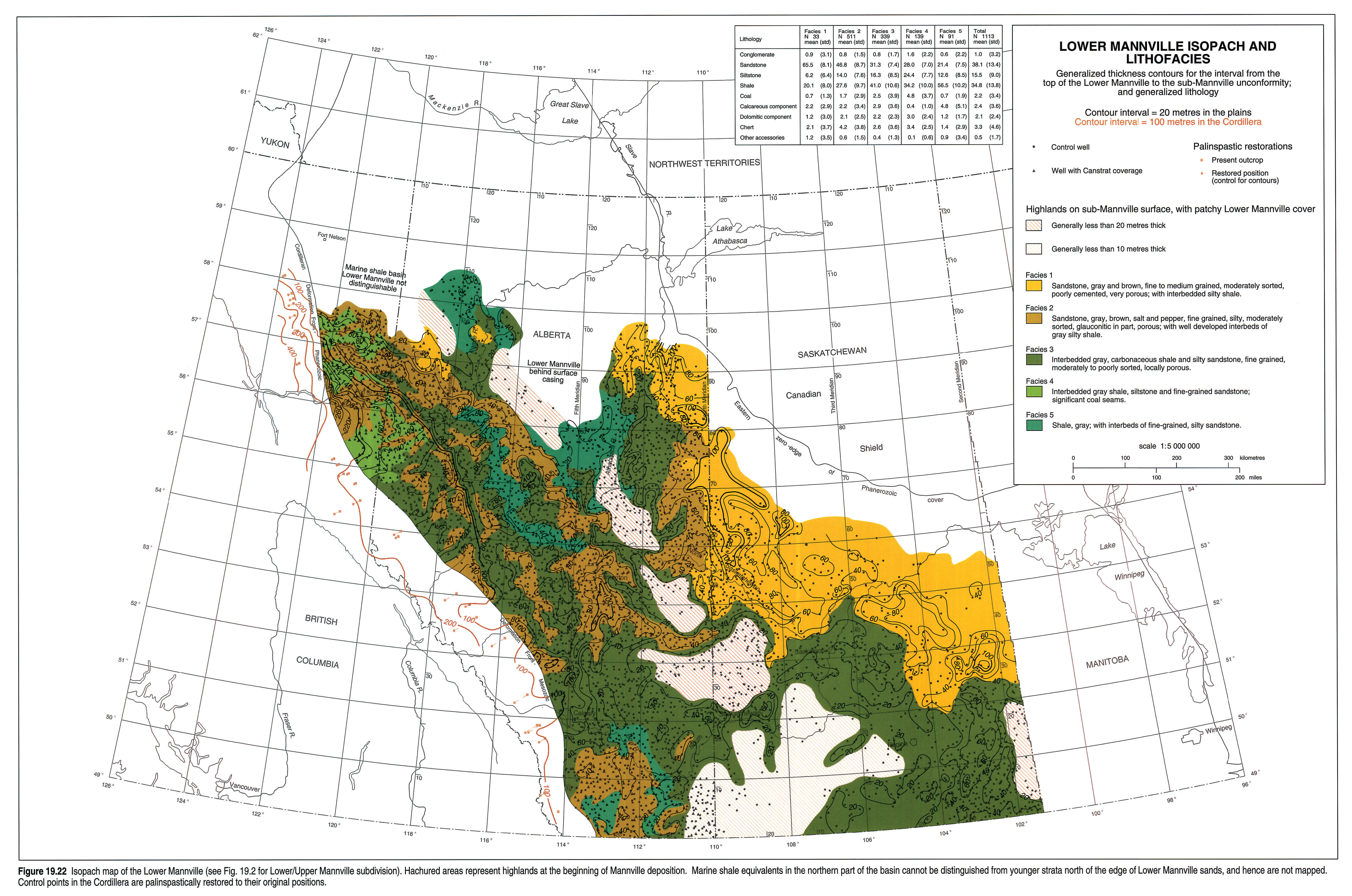
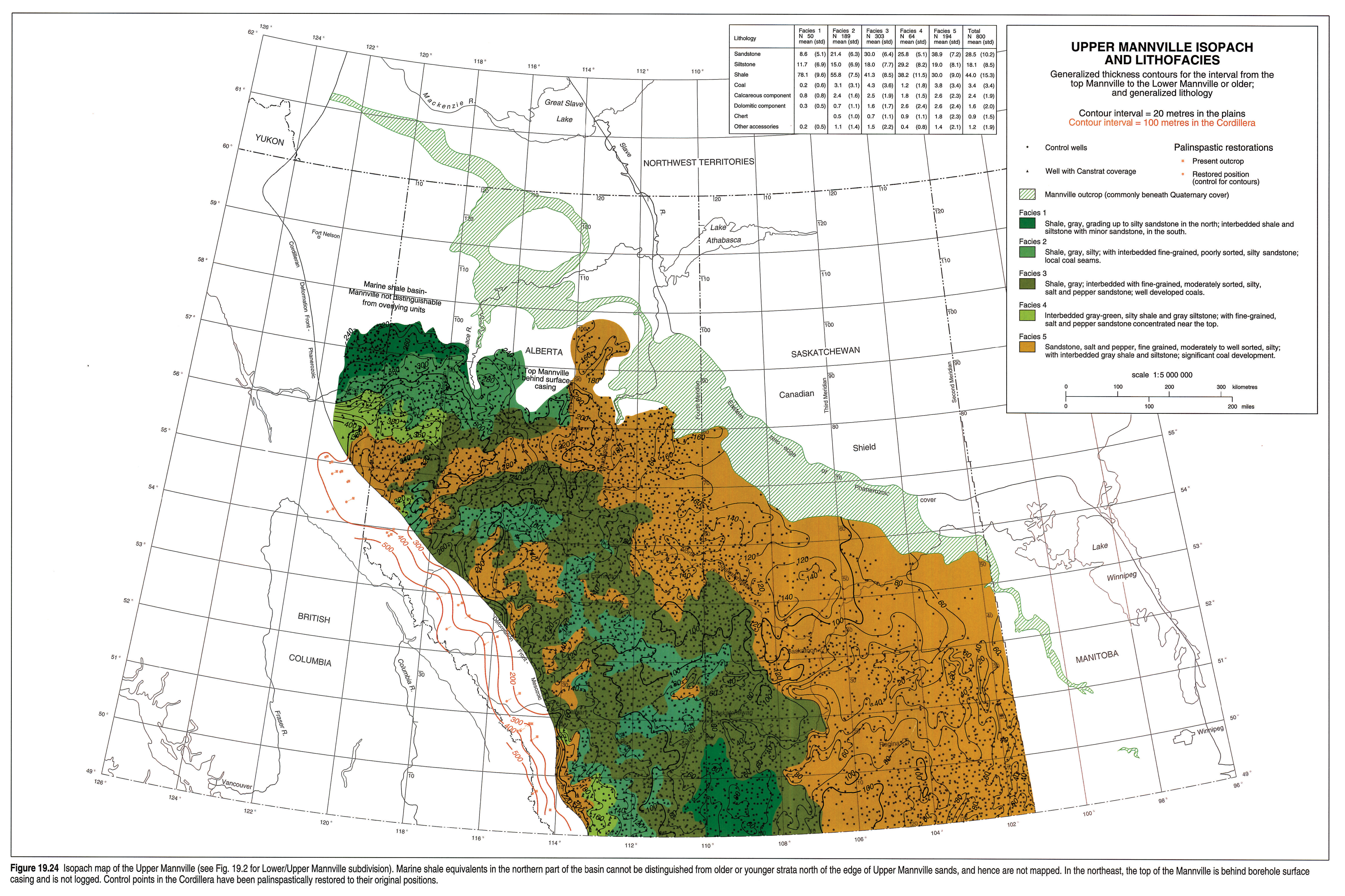
Lower and Upper Mannville Isopach Maps
Because of the stratigraphic complexity of the Mannville, only the lower and upper subdivisions can be mapped regionally. The Lower Mannville includes strata of the Cadomin/Gething and Calcareous/Ostracod paleogeographic intervals, and the Upper Mannville groups the lower Upper (Glauconitic/Bluesky), middle Upper, and upper Upper Mannville (Fig. 19.2). The paleogeographic maps are subdivided further because they are more conceptual and do not rely on accurate stratigraphic determinations in each control well.
Lower Mannville Isopach (Fig. 19.22) (Lower Mannville Oil and Gas Fig. 19.23)
Lower Mannville strata are thin to absent over the major highlands on the sub-Mannville unconformity surface, and thicken off their flanks into the Edmonton and Assiniboia valleys. Many of the smaller valleys incising the highlands and secondary to the regional valley systems cannot be resolved at this scale, but are illustrated by regional cross sections A*-A', F-F*, and G-G' (Figs. 19.17 left pane, 19.17 right pane, 19.19, 19.20). A sharp westward thickening in western Alberta marks the Fox Creek Escarpment and the eastern edge of the Spirit River Valley. To the north, lobate clusters of wells outline the Sikanni Chief, Keg River and Fort McMurray deltas, beyond which Lower Mannville marine shales cannot be distinguished from younger strata (see regional cross sections A-A* and B-B*; Figs. 19.17 left pane, 19.17 right pane, 19.15).
Upper Mannville Isopach (Fig. 19.24)
Regional tectonic elements exerted more control over Upper Mannville deposition and resulting isopach patterns. Strata thicken sharply toward the foredeep and Peace River Arch depocentres, where subsidence was greatest, as highlighted by regional cross sections A-A* and C-C' (Figs. 19.17 left pane, 19.17 right pane, 19.16). In the central and southern plains, sub-Mannville valley and ridge systems continued to control isopach patterns, although more subtly, as shown on regional cross sections A*-A', F-F* and G-G' (Figs. 19.17 left pane, 19.17 right pane, 19.19, 19.20). The influence of the Punnichy Arch is expressed as an east-west thin through the Saskatoon area.
At the northern map limit west of 116°ree;W longitude, the Upper Mannville grades to a marine shale succession within the Buckinghorse Formation (section A-A*, 19.17 left pane and 19.17 right pane). To the east, the Mannville top is behind borehole surface casing, and thus has not been determined.
Discussion
Regional lithostratigraphic correlations within the Mannville are reasonably well understood, but detailed correlations remain poorly documented. This is in part a consequence of the lack of age-diagnostic fossils in the non-marine facies that make up most of the succession, but also reflects the presence of numerous facies changes and internal disconformities. The discussion below attempts to resolve some of the stratigraphic problems, although some of the proposed correlations have not been fully substantiated.
Foothills
In the southern foothills, the Calcareous Member comprises 50 m of brackish-water facies containing a distinctive ostracod/gastropod/pelecypod faunal assemblage, separating thick continental successions above and below (Fig. 19.10). A fossiliferous black shale with the same faunal assemblage is recognized as far north as Cadomin (Tp 50). North of Ram River, this lithology is overlain by an open-marine shale that includes, and is capped by, a series of regressive coarsening-upward marine sandstones. Farther north, in the Grande Cache area, the fossiliferous shale is absent, and the middle part of the Mannville is a thick, open-marine shale (Moosebar Formation).
The brackish-water shales appear to correlate with two, thin, regressive marine cycles at the base of the Moosebar, implying that Calcareous/Ostracod strata represent a broad, shallow, brackish lake or bay developed behind a barrier island system in northwestern Alberta during the early stages of the Moosebar/Clearwater transgression. Overlying open-marine strata of the Glauconitic/Bluesky interval record the maximum advance and episodic retreat of the Moosebar Sea.
Southern and Central Plains
As described above, the Calcareous/Ostracod and Glauconitic/Bluesky intervals in the northern and central plains comprise basal fossiliferous shale and limestone beds, overlain by a series of regressive, shallow-marine sandstone/shale sequences, locally dissected by incised valleys (Fig. 19.11). The fossiliferous (Ostracod) shales have been noted in core as far north as Township 58 in the west-central plains of Alberta, where they are overlain by open-marine shales of the Wilrich Member. Forty kilometres farther north, the Ostracod shale is absent and the Wilrich rests on marine sandstones of the lower Bluesky Formation (Fig. 19.11). This implies that the Ostracod beds were deposited in a brackish bay behind a barrier island system in north-central Alberta during the initial stages of the Moosebar/Clearwater transgression, the same relationship described above in the foothills.
Correlation Across the Central Highlands
Various stratigraphic schemes have been developed to describe the Mannville in different parts of the basin (Figs. 19.2, 19.5), but it is particularly difficult to correlate those used on either side of the line of highlands in the centre of the basin (Fig. 19.14). As an example, in the Lloydminster area immediately east of the Wainwright Highlands, a complex terminology has been developed to represent abrupt vertical and lateral facies changes. West of the highlands, however, few of the Lloydminster stratigraphic markers can be distinguished, and a simpler stratigraphy is used (see regional section D-D', Fig. 19.18). Thus, our correlation of the upper Dina and Cummings members with the Ostracod beds, for example, requires consideration of the entire succession in both areas.
The central highlands profoundly affected sediment dispersal patterns as well as depositional environments. West of the highlands, Upper Mannville sandstones are composed predominantly of a volcanic/feldspathic suite of minerals derived from Cordilleran volcanic and metamorphic source areas. To the east, the Upper Mannville also includes more quartzose sandstones derived from the Precambrian Shield, and becomes highly quartzose adjacent to the Shield. Near the central highlands, Putnam (1982) interpreted volcanic/feldspathic and quartzose sandstones interfingering in the Upper Mannville as being derived from a variety of western, eastern and southern source areas.
Correlation of Valley-Fill Strata
Incision and subsequent infill of valleys occurred throughout Mannville deposition, ranging in scale from the major valley systems on the sub-Mannville unconformity to small valleys associated with local relative sea-level fluctuations (e.g., Figs. 19.11, 19.12). Strata filling major valley systems generally can be mapped regionally and assigned to well-defined stratigraphic units such as the McCloud Member, Cut Bank Member or Cadomin Formation. The fill of smaller valleys can be mapped only locally, although where several valleys can be associated with a particular incision event, their fills can be informally grouped (e.g., the Glauconitic Formation fill of the Medicine River channels of Rosenthal, 1988).
Extension of local names outside of detailed study areas is difficult to justify because of complex facies patterns and paucity of reliable regional stratigraphic markers. An example is the Sunburst Member, originally defined as a sandstone filling a local valley on the sub-Mannville surface in northern Montana. Subsequent industry usage expanded the Sunburst to include almost any basal Mannville fluvial sandstone in a larger area of southeastern Alberta and north-central Montana. Some workers have even attempted to apply the Sunburst name to brackish facies clearly associated with the Calcareous/Ostracod interval, lying hundreds of kilometres northwest of the original field area. Such extrapolations serve only to obscure understanding of an already complex stratigraphy (see Hayes, 1990, for further discussion).
Acknowledgements
We are indebted to Canadian Hunter Exploration Ltd. for a great deal of technical support and general encouragement. Ruth Nixon, John Harkness and Barb Gies in particular provided their considerable skills generously. Peter Putnam and Gordon Williams shared their insights on the Mannville, and their reviews improved this chapter.
References
- Banerjee, I. and Davies, E.H. 1988. An integrated lithostratigraphic and palynostratigraphic study of the Ostracode zone and adjacent strata in the Edmonton embayment, central Alberta. In: Sequences, Stratigraphy, Sedimentology: Surface and Subsurface. D.P. James and D.A. Leckie (eds). Calgary, Canadian Society of Petroleum Geologists, Memoir 15, p. 261-274.
- Cant, D.J. 1984. Development of shoreline-shelf sand bodies in a Cretaceous epeiric sea deposit. Journal of Sedimentary Petrology, v. 54, p. 541-546.
- Cant, D.J. and Stockmal, G.S. 1989. The Alberta foreland basin: relationship between stratigraphy and Cordilleran terrane-accretion events. Canadian Journal of Earth Sciences, v. 26, p. 1964-1975.
- Christopher, J.E. 1974. The Upper Jurassic Vanguard and Lower Cretaceous Mannville groups of southwestern Saskatchewan. Saskatchewan Department of Mineral Resources, Report 151, 349 p.
- Christopher, J.E. 1984. The Lower Cretaceous Mannville Group, northern Williston Basin region, Canada. In: The Mesozoic of Middle North America. D.F. Stott and D.J. Glass (eds). Calgary, Canadian Society of Petroleum Geologists, Memoir 9, p. 109-126.
- Duff, P. and Gilchrist, R.D. 1981. Correlation of Lower Cretaceous coal measures, Peace River Coalfield, British Columbia. British Columbia Ministry of Energy, Mines and Petroleum Resources, Paper 1981-3, 31 p.
- Finger, K.L. 1983. Observations on the Lower Cretaceous Ostracode zone of Alberta. Bulletin of Canadian Petroleum Geology, v. 31, p. 326-337.
- Flach, P.D. 1984. Oil sands geology - Athabasca deposit north. Alberta Research Council, Bulletin 46, 31 p.
- Glaister, R.P. 1959. Lower Cretaceous of southern Alberta and adjacent areas. American Association of Petroleum Geologists, Bulletin, v. 43, p. 590-640.
- Gross, A.A. 1980. Mannville channels in east-central Alberta. In: Lloydminster and Beyond: Geology of Mannville Hydrocarbon Reservoirs. L.S. Beck, J.E. Christopher, and D.M. Kent (eds). Regina, Saskatchewan Geological Society, Special Publication #5, p. 33-63.
- Harrison, D.B., Glaister, R.P., and Nelson, H.W. 1981. Reservoir description of the Clearwater oil sand, Cold Lake, Alberta, Canada. In: The Future of Heavy Crude Oil and Tar Sands. R.F. Meyer and C.T. Steele (eds.). New York, McGraw-Hill, p. 264-279.
- Hay, P. (this volume). Oil and gas resources of the Western Canada Sedimentary Basin. In: Geological Atlas of the Western Canada Sedimentary Basin. G.D. Mossop and I. Shetsen (comps.). Calgary, Canadian Society of Petroleum Geologists and Alberta Research Council, chpt. 32.
- Hayes, B.J.R. 1986. Stratigraphy of the basal Cretaceous Lower Mannville Formation, southern Alberta and north-central Montana. Bulletin of Canadian Petroleum Geology, v. 34, p. 30-48.
- Hayes, B.J.R. 1990. A perspective on the Sunburst member of southern Alberta. Bulletin of Canadian Petroleum Geology, v. 38, p. 483-484.
- Jackson, P.C. 1984. Paleogeography of the Lower Cretaceous Mannville Group of Western Canada. In: Elmworth - Case Study of a Deep Basin Gas Field. J.A. Masters (ed.). Tulsa, American Association of Petroleum Geologists, Memoir 38, p. 49-78.
- James, D.P. 1985. Stratigraphy, sedimentology and diagenesis of Upper Jurassic and Lower Cretaceous (Mannville) strata, southwestern Alberta. Unpublished Ph.D. thesis, Oxford University.
- Keith, D.A.W., Wightman, D.M., Pemberton, S.G., MacGillivray, J.R., Berezniuk, T., and Berhane, H. 1988. Sedimentology of the McMurray Formation and Wabiskaw Member (Clearwater Formation), Lower Cretaceous, in the central regional of the Athabasca Oil Sands area, northeastern Alberta. In: Sequences, Stratigraphy, Sedimentology: Surface and Subsurface. D.P. James and D.A. Leckie (eds.). Calgary, Canadian Society of Petroleum Geologists, Memoir 15, p. 309-324.
- Kramers, J.W. 1974. Geology of the Wabasca A oil sand deposit (Grand Rapids Formation). In: Oil Sands - Fuel of the Future. L.V. Hills (ed.). Calgary, Canadian Society of Petroleum Geologists, Memoir 3, p. 68-83.
- Leckie, D.A. 1985. The Lower Cretaceous Notikewin Member (Fort St. John Group), northeastern British Columbia: a progradational barrier island system. Bulletin of Canadian Petroleum Geology, v. 33, p. 39-51.
- Leckie, D.A. 1986. Rates, controls and sand-body geometries of transgressive-regressive cycles: Cretaceous Moosebar and Gates formations, British Columbia. American Association of Petroleum Geologists, Bulletin, v. 70, p. 516-535.
- Leckie, D.A., Potocki, D.J., and Visser K. 1991. The Lower Cretaceous Chinkeh Formation: a frontier-type play in the Liard Basin of Western Canada. American Association of Petroleum Geologists, Bulletin, v. 75, p.1324-1352.
- Macdonald, D.E., Langenberg, C.W., and Strobl, R.S. 1988. Cyclic marine sedimentation in the Lower Cretaceous Luscar Group and Spirit River Formation of the Alberta Foothills and Deep Basin. In: Sequences, Stratigraphy, Sedimentology: Surface and Subsurface. D.P. James and D.A. Leckie (eds.). Calgary, Canadian Society of Petroleum Geologists, Memoir 15, p. 143-154.
- McLean, J.R. 1977. The Cadomin Formation: stratigraphy, sedimentology, and tectonic implications. Bulletin of Canadian Petroleum Geology, v. 25, p. 792-827.
- McLean, J.R. 1982. Lithostratigraphy of the Lower Cretaceous coal-bearing sequence, Foothills of Alberta. Geological Survey of Canada, Paper 80-29, 46 p.
- McLean, J.R. and Wall, J.H. 1981. The Early Cretaceous Moosebar Sea in Alberta. Bulletin of Canadian Petroleum Geology, v. 29, p. 334-377.
- McNeil, D.H. 1984. The eastern facies of the Cretaceous System in the Canadian western interior. In: The Mesozoic of Middle North America. D.F. Stott and D.J. Glass (eds.). Calgary, Canadian Society of Petroleum Geologists, Memoir 9, p. 145-171.
- Mellon, G.B. 1967. Stratigraphy and petrology of the Lower Cretaceous Blairmore and Mannville groups, Alberta Foothills and Plains. Alberta Research Council, Bulletin 21, 269 p.
- O'Connell, S.C. 1988. The distribution of Bluesky facies in the region overlying the Peace River Arch, northwestern Alberta. In: Sequences, Stratigraphy, Sedimentology: Surface and Subsurface. D.P. James and D.A. Leckie (eds.). Calgary, Canadian Society of Petroleum Geologists, Memoir 15, p. 387-400.
- O'Connell, S.C. (this volume). Geological history of the Peace River Arch. In: Geological Atlas of the Western Canada Sedimentary Basin. G.D. Mossop and I. Shetsen (comps). Calgary, Canadian Society of Petroleum Geologists and Alberta Research Council, chpt. 28.
- Poulton, T.P., Christopher, J.E., Hayes, B.J.R., Losert, J., Tittemore, J., and Gilchrist, R.D. (this volume). Jurassic and lowermost Cretaceous strata of the Western Canada Sedimentary Basin. In: Geological Atlas of the Western Canada Sedimentary Basin. G.D. Mossop and I. Shetsen (comps.). Calgary, Canadian Society of Petroleum Geologists and Alberta Research Council, chpt. 18.
- Putnam, P.E. 1982. Aspects of the petroleum geology of the Lloydminster heavy oil fields, Alberta and Saskatchewan. Bulletin of Canadian Petroleum Geology, v. 30, p. 81-111.
- Putnam, P.E. 1989. Geological controls on hydrocarbon entrapment within the Lower Cretaceous Cantuar Formation, Wapella field, southeastern Saskatchewan. Bulletin of Canadian Petroleum Geology, v. 37, p. 389-400.
- Ranger, M.J., Pemberton, S.G., and Sharpe, R.J. 1988. Lower Cretaceous example of a shoreface-attached marine bar complex: the Wabiskaw 'C' sand of northeastern Alberta. In: Sequences, Stratigraphy, Sedimentology: Surface and Subsurface. D.P. James and D.A. Leckie (eds.). Calgary, Canadian Society of Petroleum Geologists, Memoir 15, p. 451-462.
- Rosenthal, L. 1988. Wave-dominated shorelines and incised channel trends: Lower Cretaceous Glauconite Formation, west-central Alberta. In: Sequences, Stratigraphy, Sedimentology: Surface and Subsurface. D.P. James and D.A. Leckie (eds.). Calgary, Canadian Society of Petroleum Geologists, Memoir 15, p. 207-220.
- Rudkin, R.A. 1964. Lower Cretaceous. In: Geologic History of Western Canada. R.G. McCrossan and R.P. Glaister (eds.). Calgary, Alberta Society of Petroleum Geologists, p. 156-168.
- Smith, D.G. (this volume). Paleogeographic evolution of the Western Canada Foreland Basin. In: Geological Atlas of the Western Canada Sedimentary Basin. G.D. Mossop and I. Shetsen (comps.). Calgary, Canadian Society of Petroleum Geologists and Alberta Research Council, chpt. 17.
- Smith, D.G., Zorn, C.E., and Sneider, R.M. 1984. The paleogeography of the Lower Cretaceous of western Alberta and northeastern British Columbia in and adjacent to the Deep Basin of the Elmworth area. In: Elmworth - Case Study of a Deep Basin Gas Field. J.A. Masters (ed.). Tulsa, American Association of Petroleum Geologists, Memoir 38, p. 79-114.
- Smith, G.G., Cameron, A.R., and Bustin, R.M. (this volume). Coal resources of the Western Canada Sedimentary Basin. In: Geological Atlas of the Western Canada Sedimentary Basin. G.D. Mossop and I. Shetsen (comps.). Calgary, Canadian Society of Petroleum Geologists and Alberta Research Council, chpt.33.
- Stott, D.F. 1968. Lower Cretaceous Bullhead and Fort St. John groups between Smoky and Peace rivers, Rocky Mountain Foothills, Alberta and British Columbia. Geological Survey of Canada, Bulletin 152, 279 p.
- Stott, D.F. 1973. Lower Cretaceous Bullhead Group between Bullmoose Mountain and Tetsa River, Rocky Mountain Foothills, northeastern British Columbia. Geological Survey of Canada, Bulletin 219, 228 p.
- Stott, D.F. 1982. Lower Cretaceous Fort St. John Group and Upper Cretaceous Dunvegan Formation of the Foothills and Plains of Alberta, British Columbia, District of Mackenzie and Yukon Territory. Geological Survey of Canada, Bulletin 328, 124 p.
- Wanklyn, R.P. 1985. Stratigraphy and depositional environments of the Ostracode Member of the McMurray Formation (Lower Cretaceous; Late Aptian-Early Albian) in west central Alberta. Unpublished M.S. thesis, University of Colorado, 289 p.
- Williams, G.D. 1963. The Mannville Group (Lower Cretaceous) of central Alberta. Bulletin of Canadian Petroleum Geology, v. 11, p. 350-368.
- Wood, J.W. and Hopkins, J.C. 1989. Reservoir sandstone bodies in estuarine valley fill: Lower Cretaceous Glauconitic Member, Little Bow Field, Alberta, Canada. American Association of Petroleum Geologists, Bulletin, v. 73, p. 1361-1382.