Chapter 20 - Cretaceous Colorado/Alberta Group of the Western Canada Sedimentary Basin |
|
| Chapter Sections |
Table 20.2a Gas production from the Upper Colorado Group |
|
|
Authors: D.A. Leckie - Geological Survey of Canada, Calgary
J.P. Bhattacharya ARCO Exploration and Production Research Technology. Plano, Texas
J. Bloch - Geological Survey of Canada, Calgary
C.F. Gilboy - Saskatchewan Energy and Mines, Regina
B. Norris - Calgary Additional Contributors: R. Campbell - Calamity Resources, Calgary
G. Plint - University of Western Ontario
M. Gilders - Calgary
G. Holmstrom - G.H. Consulting, Calgary
F.F. Krause - The University of Calgary, Calgary
G.E. Reinson - Geological Survey of Canada, Calgary
D. Safton - Sage Geological Inc.
J. Sawicki - Geotechnical Resources Ltd., Calgary
O. Sawicki - Calgary
Introduction
The middle Cretaceous Colorado/Alberta Group consists predominantly of mudstone interspersed with relatively thin sandstone and conglomerate beds. Other minor lithotypes include shaly chalk, chalky limestone, bentonite, pelecypod coquinas, horizons of fish debris, nodular phosphorite, and siderite, calcite and pyrite concretions. The Colorado Group is of significant economic importance in that it contains about 14 percent of the total Western Canada hydrocarbon reserves and about 80 percent of the reserves within the Middle Jurassic to Cretaceous foreland basin succession (Podruski et al., 1988; Porter, 1992). The largest and historically oldest gas pool in Canada occurs within the Medicine Hat Sandstone of the Colorado Group; this pool was discovered in 1890 during early exploration for coal resources.
This chapter presents an overview of the dominantly shaly Colorado and Alberta groups, hereinafter referred to as the Colorado Group. Other following chapters describe in detail the coarser clastic wedges represented by the Viking, Dunvegan and Cardium formations (Chapters 21, 22 and 23, respectively).
Previous Work
Earlier regional syntheses of the Colorado Group are in Caldwell (1984) and Williams and Burke (1964). Detailed lithostratigraphic and micropaleontological aspects of the Colorado Group in the Manitoba Escarpment and adjacent subsurface were described in McNeil and Caldwell (1981) and McNeil (1984). In Saskatchewan, detailed lithological descriptions were carried out by Simpson (1982). Stott (1963, 1967, 1982) meticulously mapped the foothills of Alberta and British Columbia, providing a comprehensive lithostratigraphy of the Upper Cretaceous strata. This lithostratigraphic framework has served as an excellent starting point for more detailed studies. The biostratigraphic zonation of Cretaceous strata in Western Canada was synthesized by Caldwell et al. (1978).
Summary lithological and stratigraphic descriptions of the units making up the Colorado Group across the basin are in Glass (1990). Highly generalized maps illustrating the extent of marine inundation were presented by Williams and Stelck (1975). Detailed paleogeographic maps illustrating the evolution of the Western Canada Sedimentary Basin are presented in Leckie and Smith (1992).
Geological Framework
The Albian to Santonian Colorado Group was deposited within the Western Canada Foreland Basin during an approximately 25 to 30 million year period. Global sea level was high during this time, with specific sea-level maxima in the Late Albian, Early Turonian and Middle Santonian (Caldwell, 1984; Haq et al., 1987). Deposition at this time was also coincident with a regional tectonic downflexing of the North American craton (Lambeck et al., 1987). The major marine inundations were separated by four major regressive pulses represented by the Peace River-Viking, Dunvegan, Cardium-Bad Heart and Milk River formations. During the highstands, warm Tethyan water from the Gulf of Mexico mixed with the cooler boreal water extending south from the Arctic to form a shallow epeiric seaway.
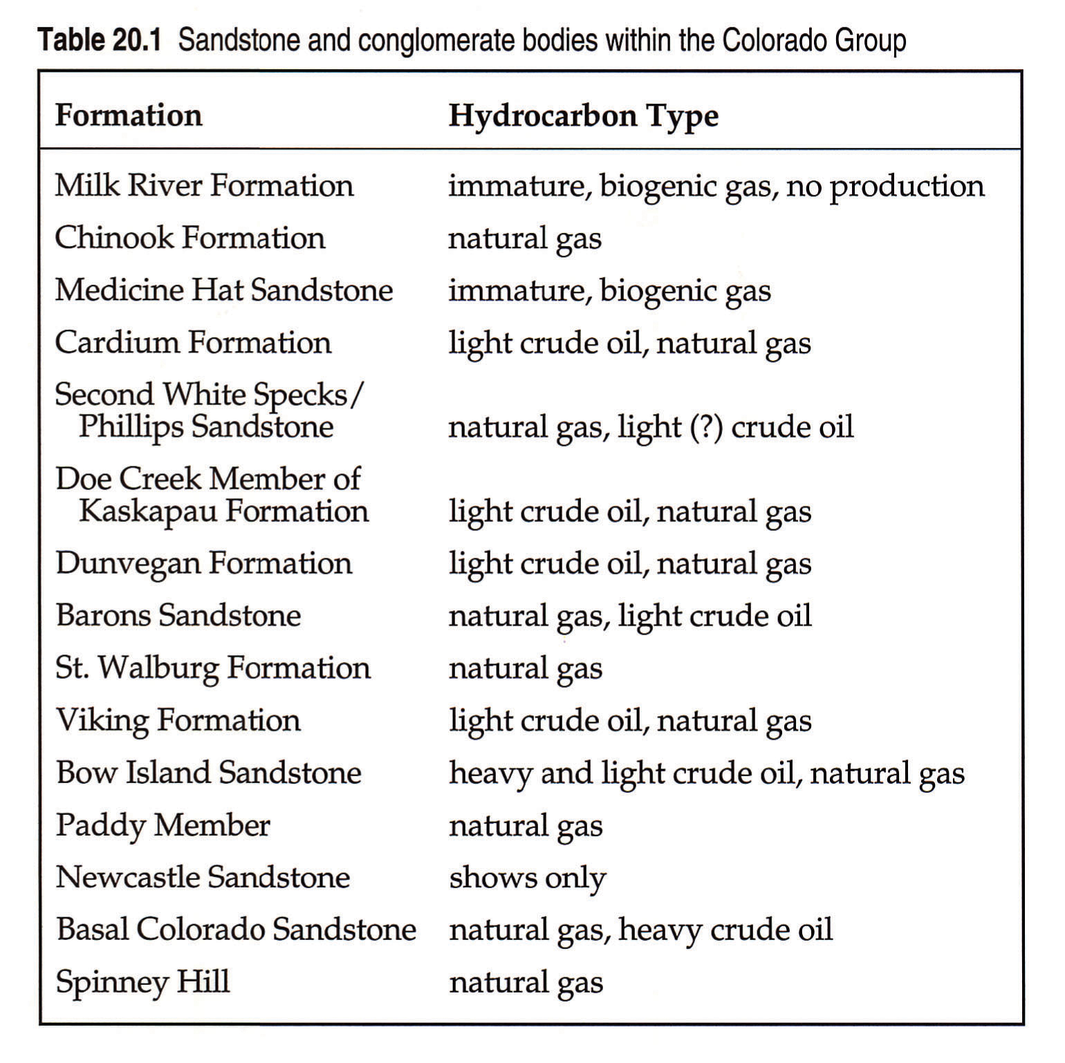
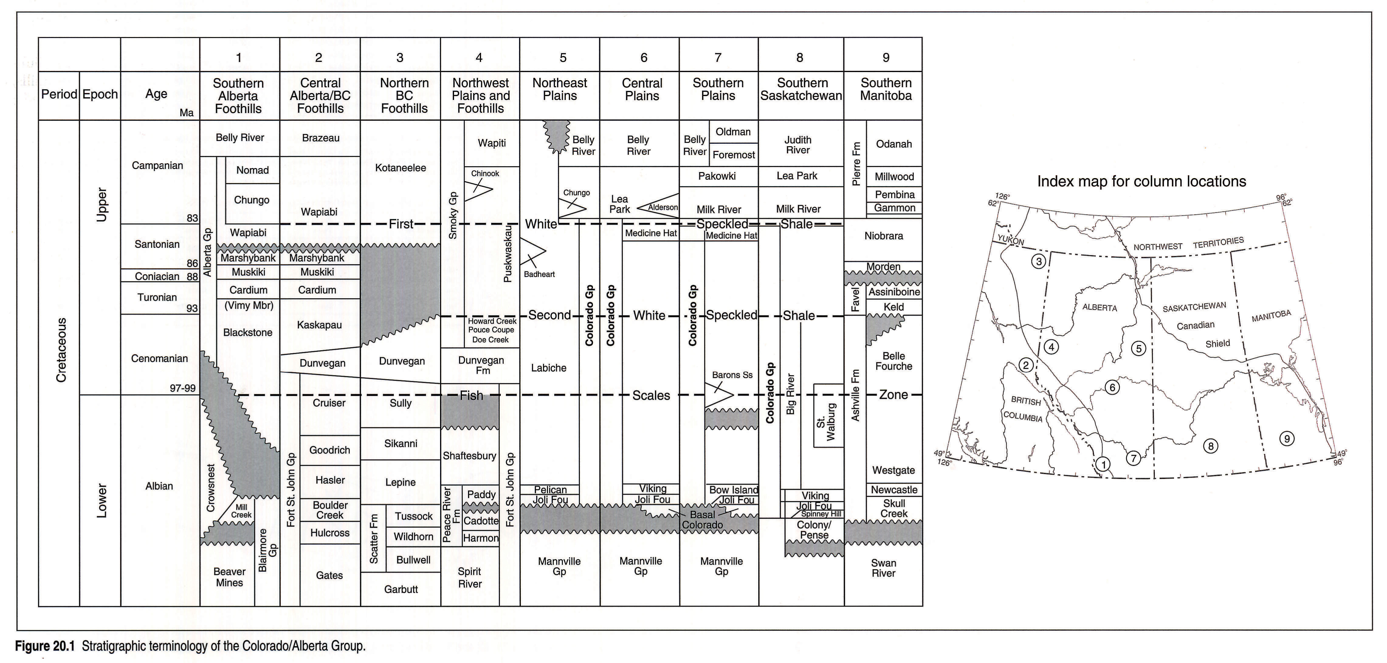
The Colorado Group contains several sandstone and conglomerate units, some of which are prolific hydrocarbon producers (Table 20.1). These include, in ascending order, the Basal Colorado Sandstone, Spinney Hill Sandstone, Viking Formation, St. Walburg Sandstone, Barons Sandstone, Dunvegan Formation, sandstones of the lower Kaskapau Formation (Doe Creek Member), sandstones of the Second White Speckled Shale (the Phillips Sandstone), Cardium Formation, the Medicine Hat Sandstone and the Alderson Member of the Lea Park Formation (Fig. 20.1). Within the Colorado Group, the First and Second White Speckled Shales, the Fish Scales Zone, and shale at the base of the Shaftesbury Formation are more radioactive than overlying and underlying shales, have high total organic carbon contents, and have considerable hydrocarbon generating potential. An interval such as the Second White Speckled Shale is potentially both a source and a reservoir rock for hydrocarbons.
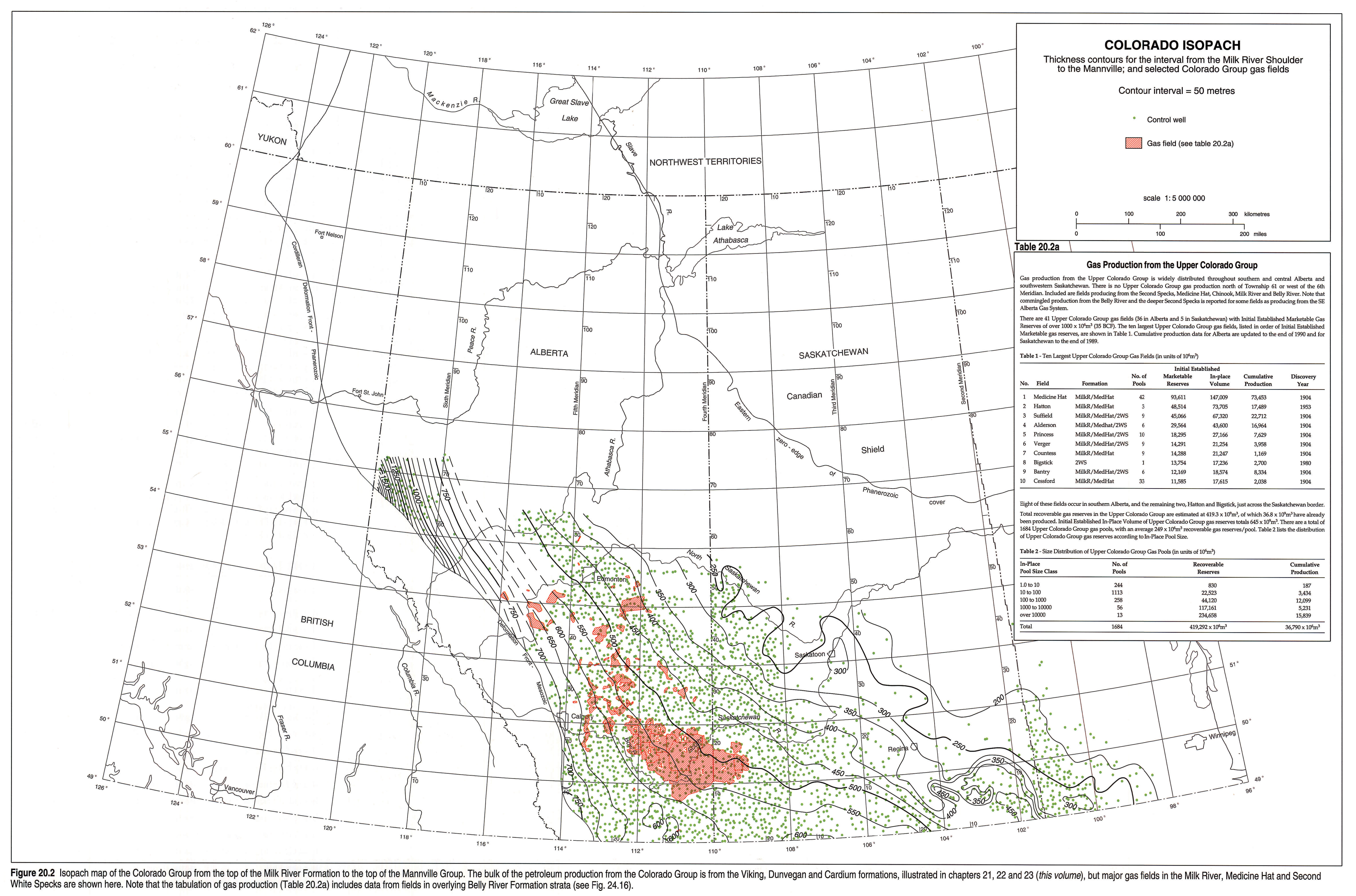
The Colorado Group thins eastward from about 700 m in southwestern Alberta to 200 m in the Manitoba Escarpment (Fig. 20.2). In northwest Alberta, the Colorado Group exceeds 1500 m in thickness where it overlies the Peace River Arch, which was subsiding during much of the Cretaceous. Regional cross sections constructed across the basin show the eastward thinning of the Colorado Group away from the Cordillera, with maximum thickening occurring in the northwest. The distribution of the Harmon, Cadotte and Paddy members is restricted to the general vicinity of the Peace River Arch where the Joli Fou Formation is absent.
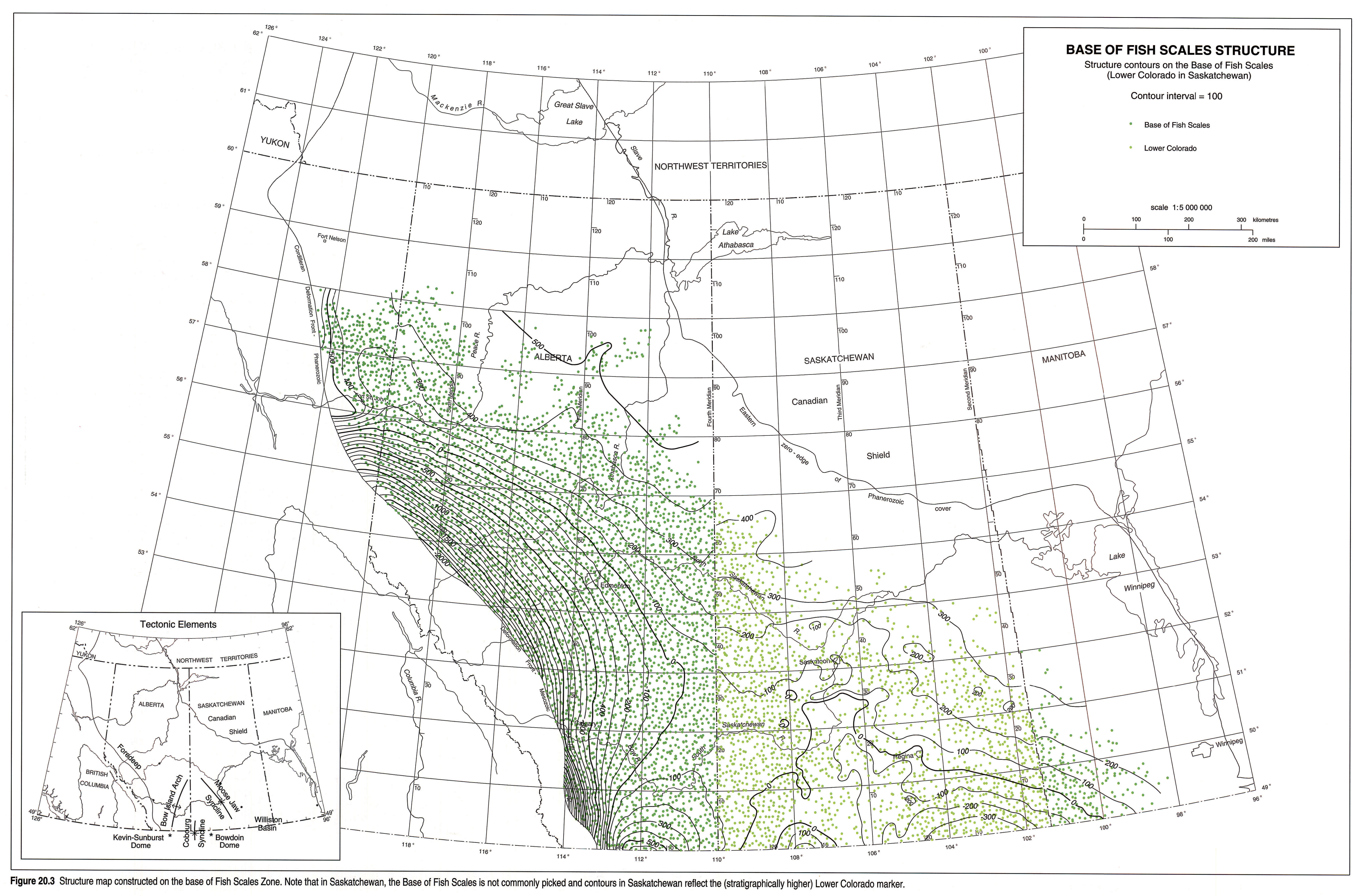
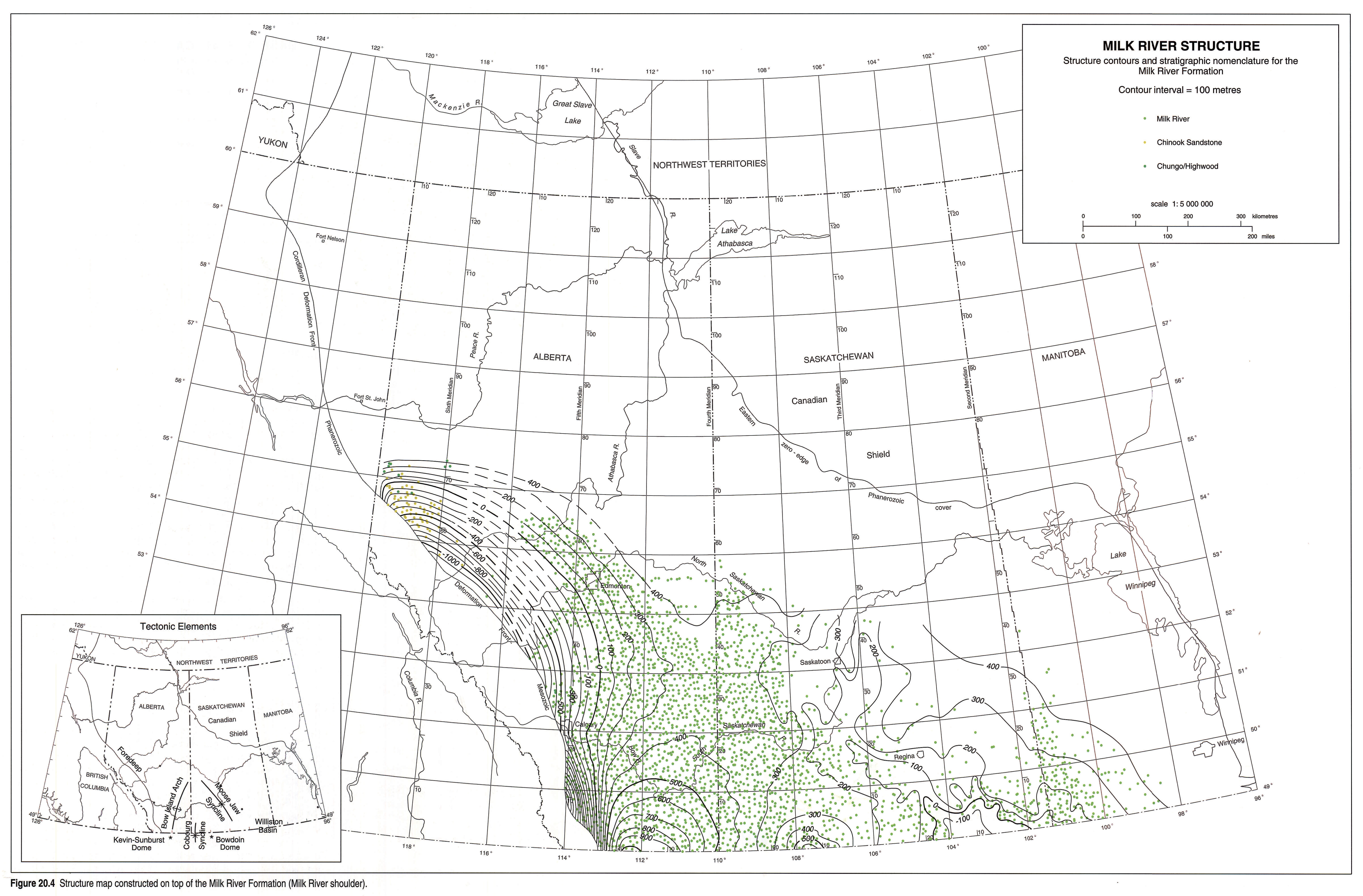
Major structural elements affecting Colorado Group deposition in the basin are represented in the structure maps constructed on the Base of Fish Scales Zone (Fig. 20.3) and the top of the Milk River Formation (Fig 20.4). The major elements identified on Figure 20.3 are similar to those identified by Williams and Burk (1964).
Positive structural elements include the Bow Island Arch (also referred to as the Sweetgrass Arch) in southeastern Alberta, and the Bowdoin Dome and Swift Current Platform in southern Saskatchewan. The Bow Island Arch separates the Alberta Basin from the Williston Basin.
Negative structural elements include the Williston Basin and its northern extension, the Moose Jaw Syncline in southern Saskatchewan and the Eastend Syncline in southwestern Saskatchewan. In southeastern Saskatchewan and southwestern Manitoba, the influence of the Williston Basin is evident in structural lows centred southeast of Regina. In northwestern Alberta and northeastern British Columbia, the Peace River Arch began to subside, with accompanying block faulting, during the Mississippian. It remained a topographic low during the Early Cretaceous and through to the Late Cretaceous (Cant, 1988). The Peace River Arch may have become a subtle high again by at least the late Turonian-early Santonian. Isolated stratigraphic and structural anomalies are attributed to local block-faulting over the Peace River Arch during the deposition of the Colorado Group.
The influence of the dissolution of Devonian-aged salts has been described elsewhere in this atlas (Wright, et al., this volume, Chapter 3). Salt solution during or prior to deposition of the Colorado Group sediments created local anomalous thickening. Salt solution subsequent to deposition of the Colorado Group has resulted in depressions on structural surfaces.
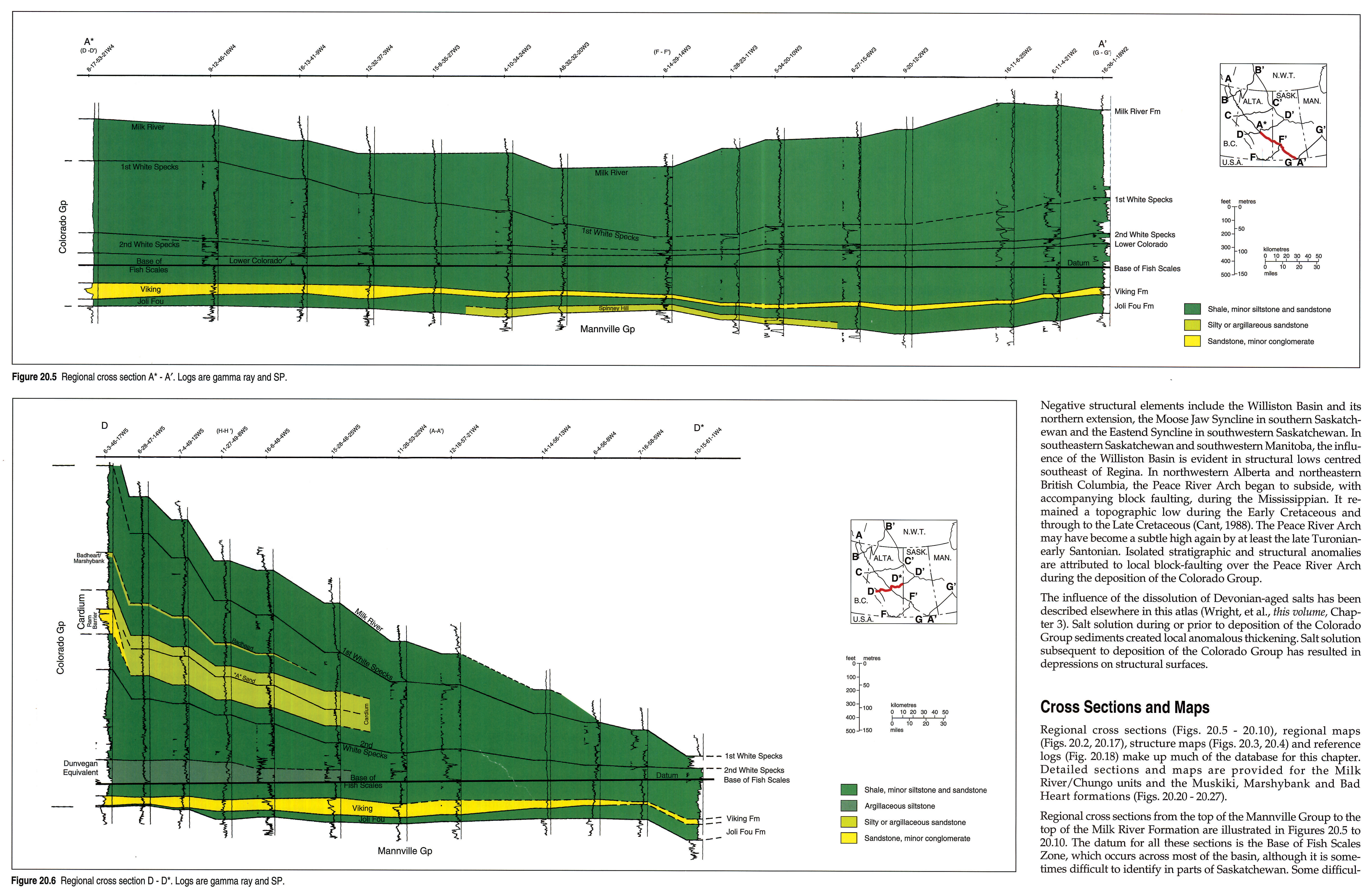
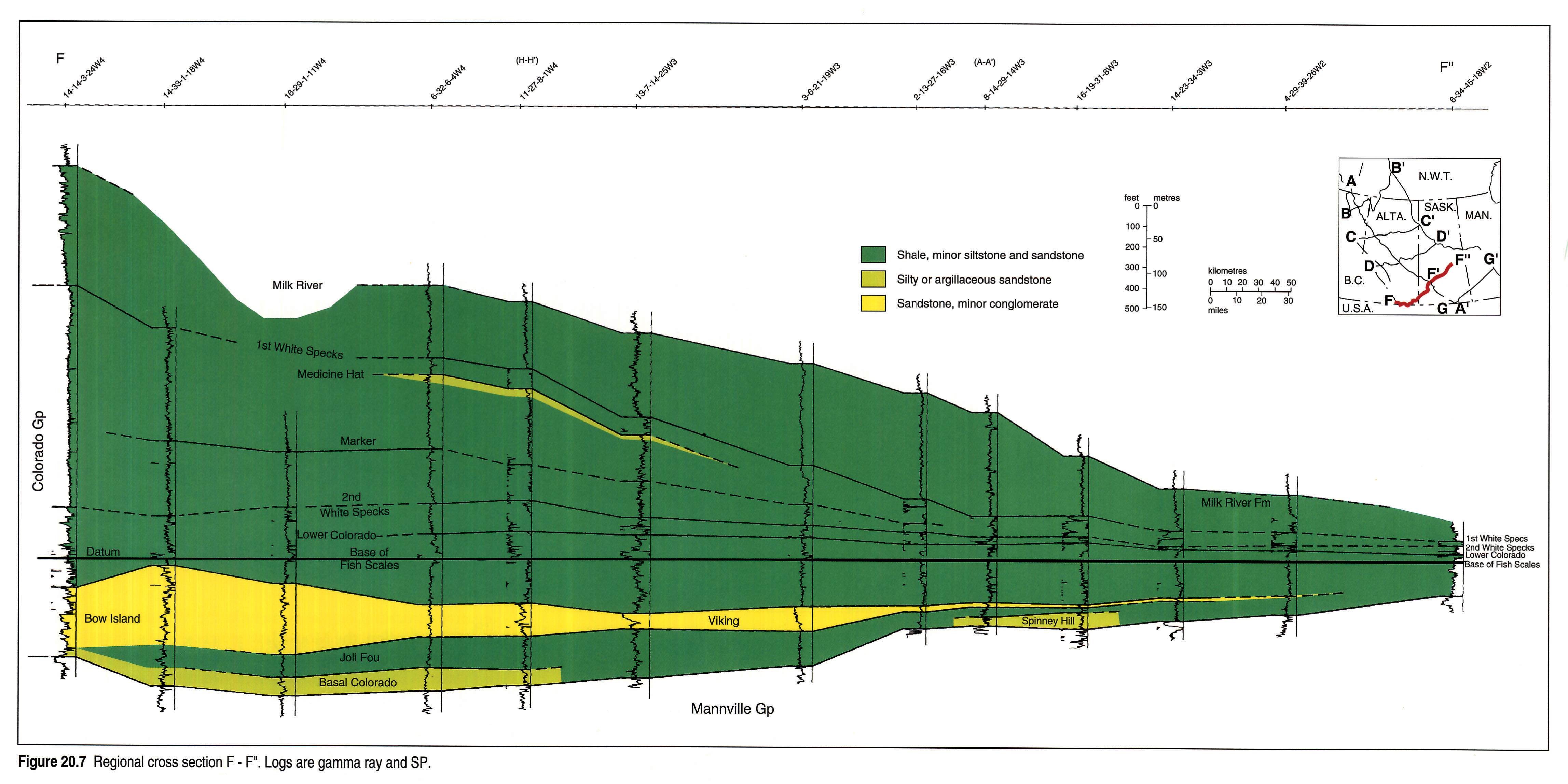
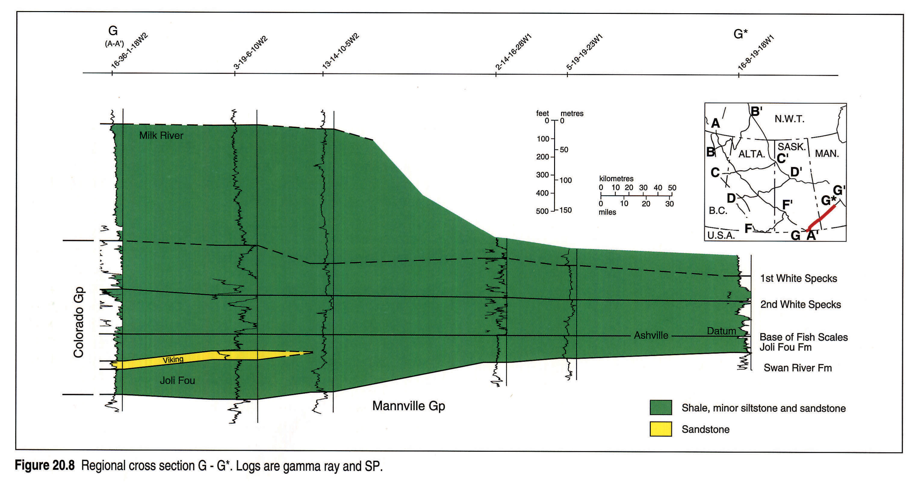
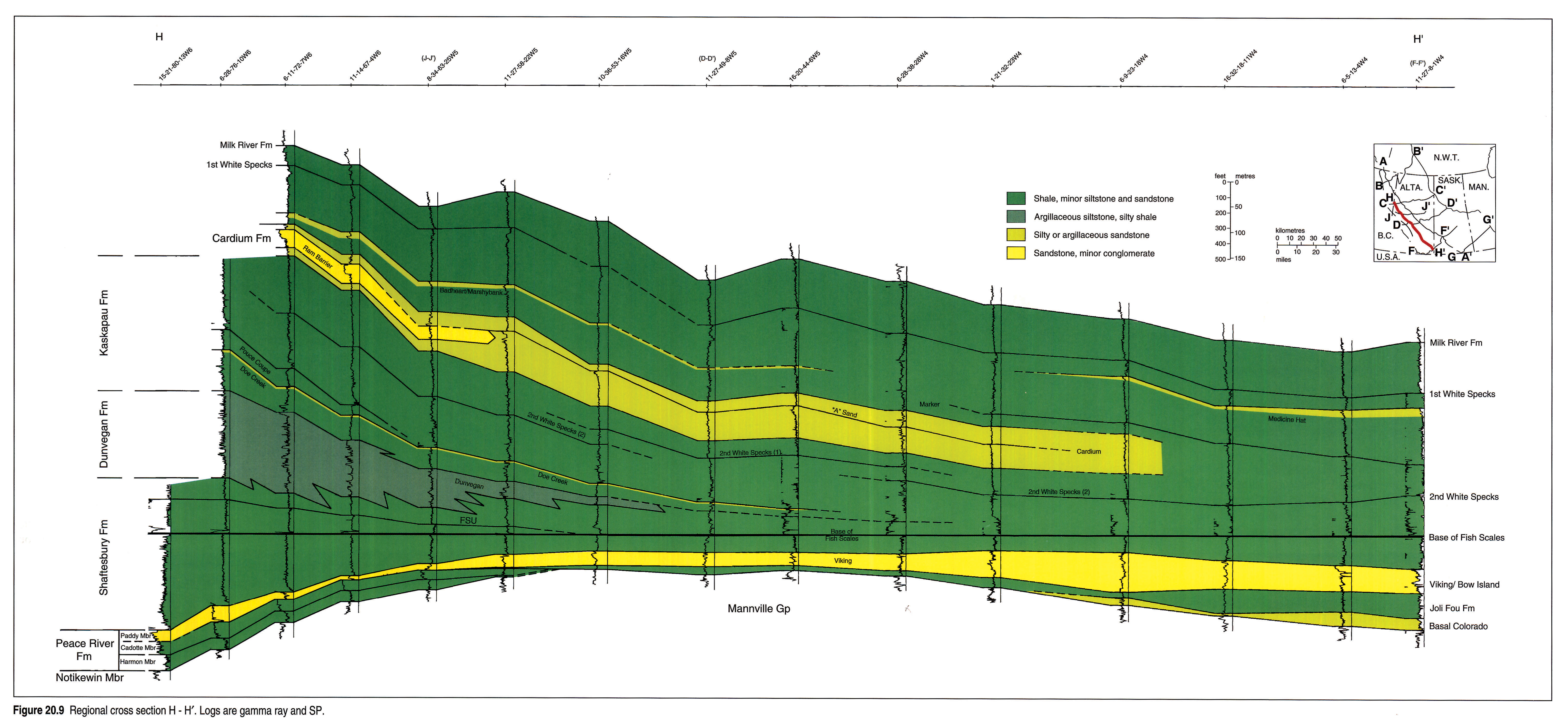
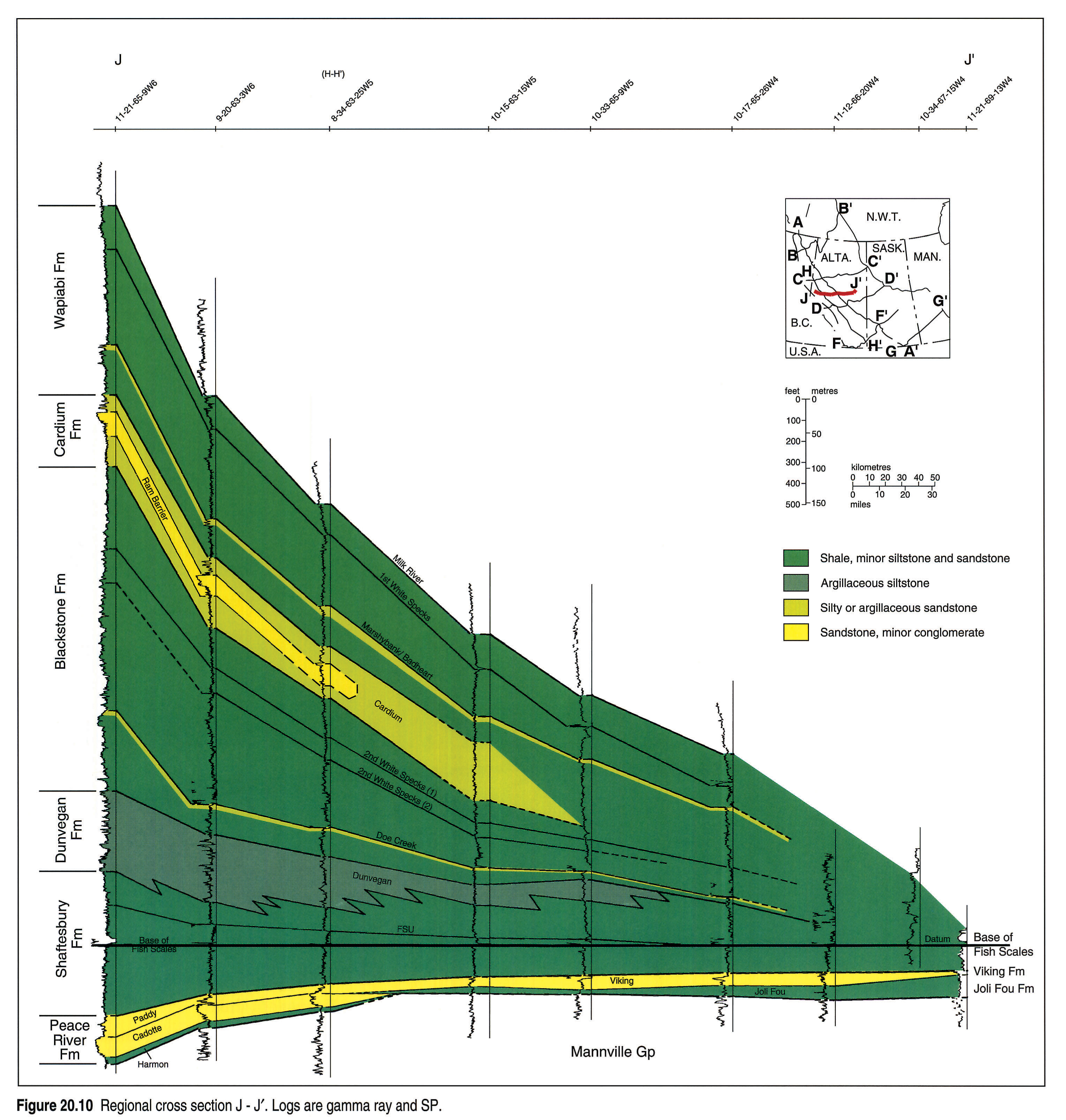
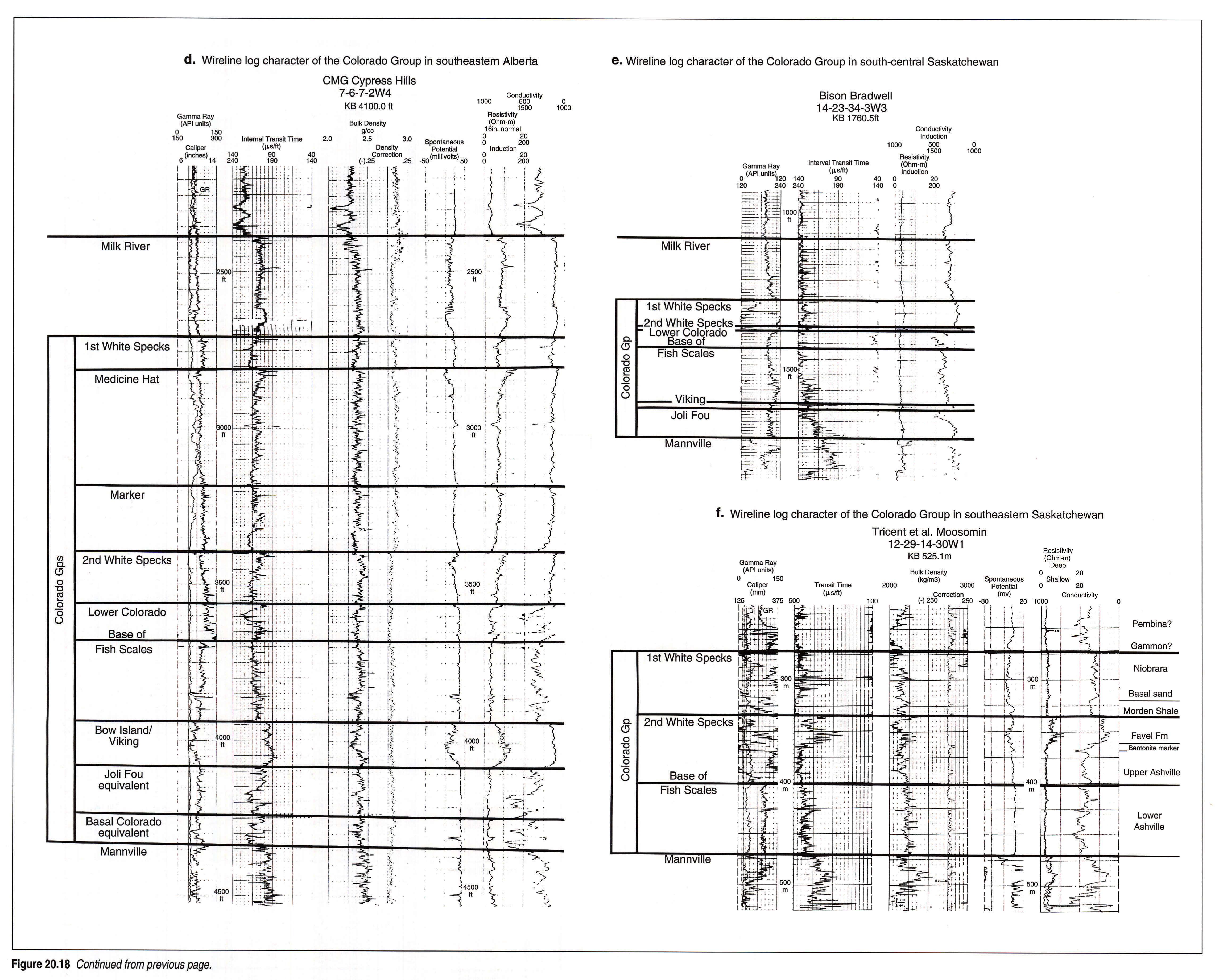
Cross Sections and Maps
Regional cross sections (Figs. 20.5, 20.6, 20.7, 20.8, 20.9, 20.10), regional maps (Figs. 20.2, 20.17), structure maps (Figs. 20.3, 20.4) and reference logs (Fig. 20.18 left pane, 20.18 right pane) make up much of the database for this chapter. Detailed sections and maps are provided for the Milk River/Chungo units and the Muskiki, Marshybank and Bad Heart formations (Figs. 20.20, 20.21, 20.22, 20.23, 20.24, 20.25, 20.26, 20.27).
Regional cross sections from the top of the Mannville Group to the top of the Milk River Formation are illustrated in Figures 20.5, 20.6, 20.7, 20.8, 20.9, 20.10. The datum for all these sections is the Base of Fish Scales Zone, which occurs across most of the basin, although it is sometimes difficult to identify in parts of Saskatchewan. Some difficulties with identification and correlation of the Second White Speckled Shale are evident in Figures 20.5, 20.9 and 20.10 because of changes in log character across the basin. Cross section H-H' (Fig. 20.9) is oriented along the axis of the western Alberta foreland basin and highlights the geometry of the Dunvegan clastic wedge. The northwestern end of the cross section stops where the units come to the surface in the Peace River valley.
The suite of reference logs (Fig. 20.18 left pane, 20.18 right pane) illustrates the variability of the different components of the Colorado Group across the basin as well as the markers used for correlation.
Stratigraphy
The stratigraphic terminology of the Colorado Group includes several informal but generally accepted names such as the First and Second White Speckled Shales and the Fish Scales Zone. The terminology, summarized in Figure 20.1, varies from province to province and between regions in the provinces. Since the Colorado Group is a predominantly marine shale succession, it has been well constrained biostratigraphically using foraminifera (Caldwell et al., 1978; McNeil and Caldwell, 1981), ammonites (Jeletzky, 1971) and microflora (Singh, 1983).
The Colorado Group was informally subdivided by Rudkin (1964) into upper and lower subgroups separated by the Base of Fish Scales Zone. In Saskatchewan, where the Fish Scales Zone is not always evident, Simpson (1982) subdivided the Colorado Group at the lower of two calcareous speckled shales (the Second White Speckled Shale). Neither subdivision is used herein.
The term Alberta Group is restricted to those strata south of the Smoky River in the southern Alberta Foothills and includes the Blackstone, Cardium and Wapiabi formations (Fig. 20.1). In northwestern Alberta and northeastern British Columbia, correlative strata include the Shaftesbury and Dunvegan formations and that part of the Smoky Group comprising the Kaskapau, Cardium, Muskiki, Marshybank, Badheart and lowermost Puskwaskau formations. In the subsurface of Alberta and Saskatchewan, the Colorado Group is used. In Manitoba, strata equivalent to the Alberta and Colorado groups are called the Ashville, Favel, Morden and Niobrara formations (McNeil and Caldwell, 1981). Within the Ashville Formation, only the Newcastle Member consists predominantly of sandstone. In northernmost British Columbia, correlative strata are the upper Lepine, Sikanni, Sully, Dunvegan and lower Kotaneelee formations.
Stratigraphic History
Basal Contact and Units
The base of the Colorado Group is represented by a basin-wide unconformity. The Colorado Group overlies the Blairmore Group in western Alberta, the Mannville Group in the subsurface of southern Alberta and Saskatchewan, the Cadotte Member of the Fort St. John Group in northeastern British Columbia and northwestern Alberta, and the Swan River Formation in Manitoba (Figs. 20.1 and 20.5, 20.6, 20.7, 20.8, 20.9, 20.10). The basal contact of the Colorado Group with the Mannville Formation is generally represented by a thin conglomerate layer containing chert or intraformational shale clasts. In the Manitoba Escarpment, the unconformity likely occurs within the Swan River Formation. The upper part of the Swan River is marine (Pense equivalent) and the lower part is terrestrial (Cantuar equivalent).
The lowermost formal lithostratigraphic unit of the Colorado Group is represented by the Spinney Hill Sandstone in eastern and central Saskatchewan, the Basal Colorado Sandstone in southeastern Alberta and shale of the Joli Fou Formation in most other areas (Figs. 20.1 and 20.5, 20.6, 20.7, 20.8, 20.9, 20.10).
The Basal Colorado Sandstone, in southeastern Alberta, southern Saskatchewan, northern Montana and North Dakota, is a thin (less than m thick), sheet-like unit underlying the Joli Fou marine shales and overlying the non-marine Mannville Group (Banerjee, 1989). In the Cessford area (Tp 22-26 R 10-16W4), the Basal Colorado Sandstone (also called Cessford Sand) occurs as a northwest-trending sandstone body, 20 km wide, 6 to 8 m thick, and situated in a paleotopographic low. In Saskatchewan, the approximately correlative Spinney Hill Formation is a grayish to yellowish green, very fine- to coarse-grained sandstone with noncalcareous shale interbeds and glauconite. Other lithotypes include intraformational conglomerates, clasts of nodular phosphorite, pelecypod coquinas and concretions of siderite and pyrite. The formation is up to 36.6 m thick and occurs as a sandstone body up to 60 km wide in central Saskatchewan (Simpson, 1982).
In northwest Alberta and northeast British Columbia, the basal contact of Colorado Group sediments is represented by a major erosion surface between the Paddy and Cadotte members of the Peace River Formation (Figs. 20.9, 20.10). This unconformity has bevelled the underlying Cadotte and Harmon members toward the east and south. Westward, in the Rocky Mountain Foothills of northeastern British Columbia, the unconformity approximately corresponds to the position of the lowermost paleosols within the Boulder Creek Formation (Leckie et al., 1989).
Joli Fou Formation
The Upper Albian Joli Fou Formation (Figs. 20.1 and 20.5, 20.6, 20.7, 20.8, 20.9, 20.10) is a dark gray, noncalcareous marine shale with a small proportion of interbedded fine- to medium-grained sandstone. Minor amounts of nodular phosphorite, bentonite, pelecypod coquinas and concretions of siderite, calcite and pyrite also occur. The Joli Fou Formation is extremely widespread, and is distributed throughout the subsurface, except in parts of northwestern Alberta and northeastern British Columbia (Figs. 20.9, 20.10) where it has been apparently truncated by an unconformity at the base of the Paddy Member. In the Manitoba Escarpment, the Joli Fou Formation is called the Skull Creek Member. In western and central regions, the Joli Fou Formation disconformably overlies the Mannville Group where the Basal Colorado/Spinney Hill are absent, and underlies the Viking Formation, disconformably in places. In eastern Saskatchewan, the Joli Fou Formation is underlain by the Swan River Sandstones, and in parts of Manitoba, it locally overlies Jurassic-aged sediments. The Joli Fou passes laterally southwestward into the Bow Island Formation (Fig. 20.7) and is not known to occur in outcrop of the Rocky Mountain Foothills. It is exposed and has a type section along the Athabasca River (Wickenden, 1949). Fauna within the Joli Fou shale suggest that the marine seaway extended from central Alberta to the Gulf of Mexico.
Viking Formation and Equivalent Units
The Albian Viking Formation, which is found in central and southern Alberta and Saskatchewan, was first named by Slipper (1918) to describe a gas-bearing sandstone encased in shale in east-central Alberta. Correlative units (Fig. 20.1) include the Bow Island Formation in southwestern Alberta (Fig. 20.7), the Newcastle Sand in Manitoba (Fig. 20.8), the Pelican Formation in northeastern Alberta, the Paddy Member (Peace River Formation) in the northwestern Alberta and northeastern British Columbia subsurface (Fig. 20.9), part of the Walton Member of the Boulder Creek Formation in northeastern British Columbia, and the Flotten Lake Sandstone in Saskatchewan. The Bow Island Formation thins eastward and northward from the Rocky Mountain Foothills, where it crops out as the Mill Creek Formation.
The Viking Formation and equivalent units are an eastward-thinning wedge of coarse clastic detritus, which extends from British Columbia to Saskatchewan. In central Alberta, the thickness of the Viking Formation is 15 to 30 m; southward, it thickens to more than 75 m, and eastward, it decreases until the unit pinches out in central and eastern Saskatchewan. The formation is described in detail by Reinson et al. (this volume, Chapter 21). It consists of interbedded fine- to coarse-grained marine sandstone and conglomerate but grades into non-marine sediments in southwestern Alberta. In much of southeastern Alberta and southwestern Saskatchewan, the Viking Formation consists of multiple, upward-coarsening cycles. Elsewhere, it is a single sandstone body only a few metres thick. Sandstone- and conglomerate-filled channels are present in several areas such as the Sundance, Edson and Crystal oil pools of west-central Alberta. Conglomerates occur as far east as the Dodsland-Hoosier area in Saskatchewan.
Distribution of the Upper Albian Paddy Member is restricted to that area defined by the Peace River Arch in northeastern British Columbia and northwestern Alberta. The Paddy Member is a heterolithic sandstone, siltstone and shale that thins eastward from 90 m near the Rocky Mountain Foothills to less than 5 m in the Interior Plains (Tp 70, R 27W5). The Paddy Member was deposited under brackish-water conditions in the inner to outer reaches of a large estuarine system (Leckie and Singh, 1991). Westward, sediment becomes increasingly fluvial in nature. Much of the Paddy Member in northwestern Alberta was deposited within a broad, shallow valley, a few hundred kilometres long and several tens of kilometres wide, which was cut into previously deposited sediments of the Cadotte Member (Leckie et al. 1990). A thick sequence of paleosols in the correlative Boulder Creek Formation from the Rocky Mountain Foothills (Leckie et al., 1989) is related to the valley incision and subsequent sea level rise.
The Flotten Lake Sand in west-central Saskatchewan and east-central Alberta north of Township 50 is an interval of sandstone and shale approximately equivalent to the Viking Formation (Simpson, 1982). Up to 21.3 m thick, it is a fine- to medium-grained sandstone with minor shale interbeds. The Flotten Lake Sandstone thins and decreases in grain size toward the southeast.
In Manitoba, the Newcastle Member consists of bioturbated, interbedded fine-grained sandstones and shales up to 12 m thick (McNeil and Caldwell, 1981). In southeastern Saskatchewan and southern Manitoba, the unit forms lobate sand bodies 12 to 23 m thick. Sandstones in the upper portion of the Newcastle Sandstone are more sheet-like.
In northeastern Alberta and northwestern Saskatchewan, the St. Walburg Sand consists of interbedded sandstone, siltstone and shale occurring below the Fish Scales Zone. The sandstone is fine grained and highly quartzose, glauconitic and kaolinitic. It is present only north of Township 46 and thickens northward to a maximum of 32.9 m (Simpson, 1982).
Westgate Member
The Upper Albian Westgate Member (McNeil and Caldwell, 1981) comprises shale above the Newcastle and below the Belle Fourche members. The shale is about 20 m thick and consists of dark mudstone with minor amounts of bioturbated silty shale and bentonite. The top of the unit is drawn at the Base of Fish Scales Zone of the Belle Fourche Member.
Fish Scales Zone
The Fish Scales Zone (Figs. 20.1 and 20.5, 20.6, 20.7, 20.8, 20.9, 20.10) is a basin-wide marker that demarcates the Albian/Cenomanian boundary (Lower/Upper Cretaceous). It contains abundant fish remains (scales and skeletal material) within finely laminated, generally nonbioturbated sandstone and siltstone. Pebbles and nodular phosphorites occur locally. The Fish Scales Zone is composite, and there may be at least three such beds across the basin.
The Fish Scales Zone is characterized by high organic carbon contents and a low concentration of benthic foraminifera, and is interpreted as representing deposition under poorly oxygenated bottom conditions. In Saskatchewan and Manitoba, the Base of Fish Scales Zone may represent a major hiatus with substages missing below and above it (Caldwell et al., 1978; Bhattacharya and Posamentier, this volume, Chapter 25), whereas in western Alberta, strata above and below the marker unit appear to be more conformable (Stelck and Armstrong, 1981).
The Fish Scales Zone ranges in thickness from less than 1.5 to 21 m and consists of very fine- to fine-grained sandstone, siltstone and shale with abundant fish scales and skeletal material. Chert granules and pebbles as well as nodular phosphorite occur locally. North and Caldwell (1975) noted that the Textularia alcesensis and most of the Verneuilinoides perplexus and Flabellammina gleddiei zones associated with the Fish Scales Zone were missing and presumed eroded in central Saskatchewan. The Fish Scales Zone is poorly defined in central Saskatchewan and is commonly difficult to recognize on wireline logs. In Manitoba, the Fish Scales Zone occurs within the lowermost 6 to 10 m of the Belle Fourche Member (Late Albian to Middle Cenomanian). Farther west, and in the northern United States, the Fish Scale Marker Bed occurs near the top of the Mowry Shale. Also within the Belle Fourche Member (Fig. 20.1) and above the Fish Scales Zone, the Ostrea beloiti limestone beds represent a distinctive marker consisting of inoceramid or ostreid fragments (McNeil and Caldwell, 1981) which, with an associated bentonite, can be traced as far south as Oklahoma and westward into Montana. McNeil and Caldwell (1981) considered this bentonite to correspond to the "X" bentonite in the United States. A disconformity separates the Belle Fourche Member from the overlying Keld Member of the Favel Formation (McNeil and Caldwell, 1981).
Barons Sandstone
In southwestern Alberta, the Cenomanian Barons Sandstone overlies the organic-rich, radioactive shales of the Fish Scales Zone (Fig. 20.1). The Barons Sandstone includes a series of isolated pods of sandstone and conglomerate up to 7 m thick, 3 to 5 km wide and 5 to 15 km long. The sandstones thicken westward and become more continuous toward the Rocky Mountain Foothills.
Big River Formation
In Saskatchewan, the term Big River Formation was assigned by Simpson (1982) to the interval between the top of the Viking Formation or Flotten Lake Sand and the base of the Second White Speckled Shale. The formation varies from 42.7 to 150 m in thickness. It is predominantly shale, with minor amounts of fine- to medium-grained sandstone, pelecypod and fish debris, thin chert-pebble layers, bentonite and phosphatic sandstone. The Fish Scales Zone and the St. Walburg Sandstone occur within the Big River Formation.
Upper Albian Outcrop
In the Rocky Mountain Foothills of southern Alberta, deposits equivalent to the subsurface Joli Fou, Viking and lowermost Colorado shales up to the Fish Scales Marker Bed are not recognized. The lowest sediments of the Blackstone Formation appear to have been deposited diachronously. In southwestern Alberta, the lowermost Blackstone Formation falls within the late Cenomanian Dunveganoceras Zone (Stott, 1963) whereas northward, it lies within the Late Albian Neogastroplites Zone.
The Crowsnest Formation in southwestern Alberta is considered a stratigraphic unit within the Blairmore Group. However, the formation may be, in part, correlative with the Joli Fou and Viking formations of the Colorado Group (Fig. 20.1). The age of volcanic agglomerates making up the Crowsnest Formation is poorly constrained but is generally considered to be Late Albian. Source areas or pipes for the volcanic detritus are thought to be in the Ma Butte and Coleman areas, where maximum sediment thicknesses of up to 484 m also occur.
Dunvegan Formation
The middle/upper Cenomanian Dunvegan Formation represents a southeastward thinning and fining, fluviodeltaic wedge deposited above the Shaftesbury Formation (Fig. 20.6; Stott, 1982). The formation is recognized in northwestern Alberta, northeastern British Columbia and southeastern Yukon Territory and reaches up to 380 m in thickness, thinning eastward and southward. Outcrops in northeastern British Columbia and southern Yukon Territory are of conglomerates and coarse-grained sandstones deposited in a braided-river and alluvial-plain setting. In northwestern Alberta, at least ten sand-rich, progradational cycles separated by regional transgressive surfaces represent the southeastward advance of the Dunvegan Formation (Bhattacharya, 1988; Bhattacharya and Walker, 1991). The progradation, though attributed to global lowering of sea level at 94 Ma (Bhattacharya, 1988), also coincides with a major uplift in the Omineca and Intermontane belts (Stott, 1982). The Dunvegan has been recognized as far south as the Athabasca River (Stott, 1963). Farther south, the Dunvegan Formation is replaced by marine siltstone and shale beds of the Sunkay Member of the Blackstone Formation, where sedimentation was dominated largely by pelagic deposition. The Dunvegan Formation is described in considerable detail by Bhattacharya (this volume, Chapter 22).
Kaskapau Formation
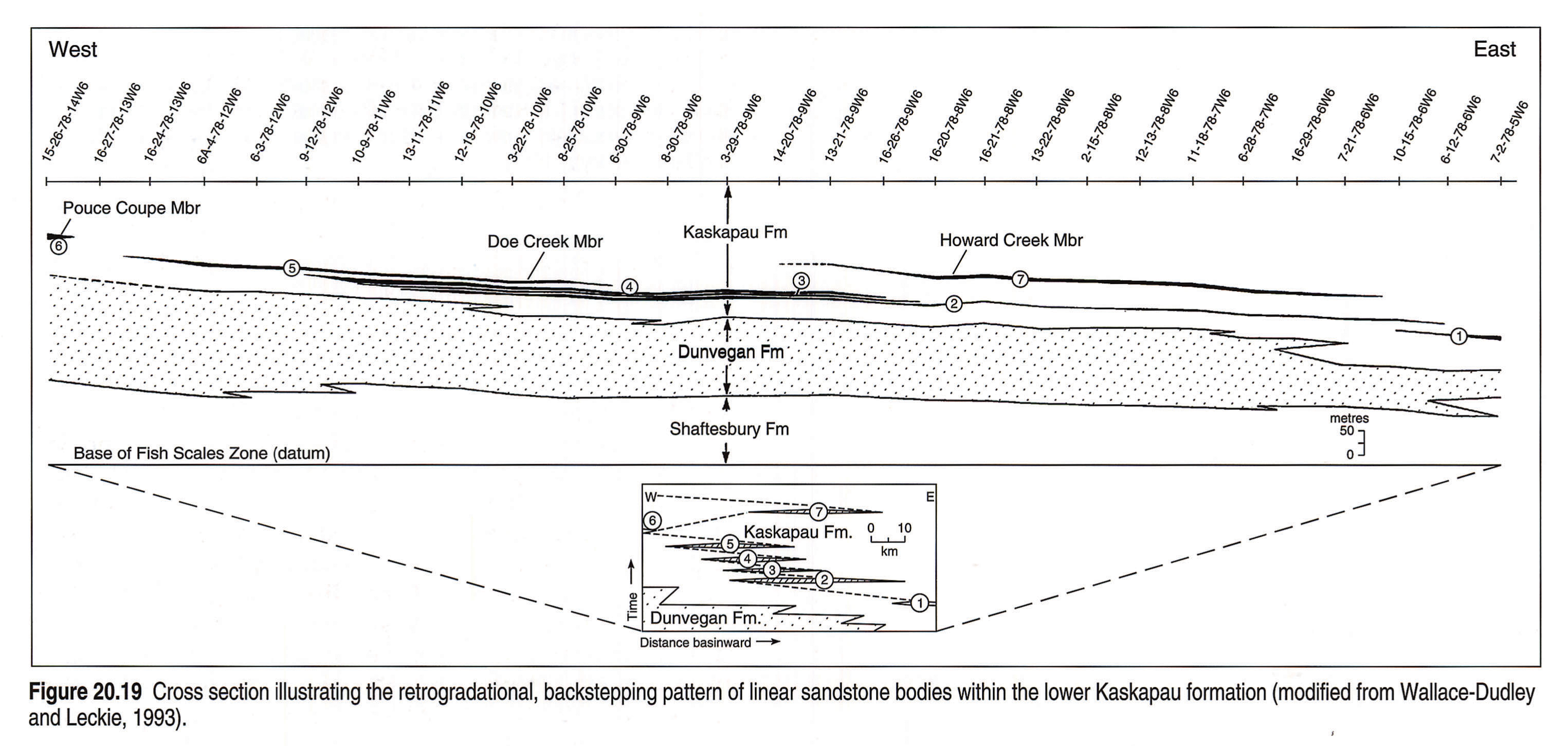
The Kaskapau Formation in northwestern Alberta is a predominantly shale succession 250 to 860 m thick lying between the Dunvegan and Cardium formations (Figs. 20.1, 20.9). Directly above the Dunvegan Formation, the Cenomanian to Turonian Kaskapau Formation contains a series of northeast-trending, shingled and backstepping, shallow-marine sandstone bodies encased in marine shale (Wallace-Dudley and Leckie, 1993, in press). These are, in ascending order, the Doe Creek, Pouce Coupe and Howard Creek members, which were deposited in a generally retrogradational pattern, following the regional transgression of the Dunvegan Formation (Fig. 20.19). The Doe Creek Member consists of several discrete, 0.5 to 7 m thick, sandstone bodies which are 21 to 37 km long and 5 to 7 km wide. The Howard Creek Member underlies the organic-rich, radioactive shales of the Second White Speckled Shale, which likely was the source for hydrocarbons in the Doe Creek Member. The Tuskoola and Wartenbe sandstones are poorly understood units within the Kaskapau Formation, occurring above the Vimy Member in outcrop in northeastern British Columbia (Stott, 1967). In southwestern Saskatchewan and southeastern Alberta, the thin, shallow-marine Phillips Sandstone/Second White Speckled Sandstone may be correlative with the sandstones of the lower Kaskapau Formation. The Phillips Sandstone occurs about 6 m below the top of the Second White Speckled Shale and can be up to 38 m thick. Geographically, the sandstone coincides with the location of the Sweetgrass Arch (Fig. 20.3).
Second White Speckled Shale/Favel Formation
The Second White Speckled Shale is a basin-wide marker named from early drillers' reports of abundant white specks in the shale, now known to be sand-sized fecal pellets comprising coccoliths and coccospheres, concentrated by currents. The shale is characterized by a high total organic carbon content, high hydrogen indices and high radioactivity on well logs. Other elements include rare, thin, coarse- to very coarse-grained sandstone beds, ammonites, peleycpods (Inoceramus), bentonites, pyrite, calcite concretions and fish debris. On gamma-ray logs the Second White Speckled Shale interval is typically radioactive as a result of elevated uranium contents associated with abundant kerogen in the shale. Discrete radioactive spikes also occur as a result of bentonites deposited in the shales.
The Second White Speckled Shale is the northern correlative of part of the Greenhorn Formation in the United States and appears to correspond to a global anoxic event and maximum sea-level rise that occurred near the end of the Cenomanian (Kauffman, 1977). In the western regions of the basin, adjacent to the Rocky Mountain Foothills where the source rock is mature, considerable volumes of liquid hydrocarbons have been generated. In eastern Alberta, Saskatchewan and Manitoba, sandy units in the Second White Speckled Shale form an important reservoir for sweet, dry, biogenic methane.
The calcareous, non-concretionary shale making up the Vimy Member of the Blackstone and the middle Kaskapau formations in northern Alberta and British Columbia is, in part, correlative with the widespread Second White Speckled Shale.
In Manitoba, the equivalent Favel Formation consists of highly fossiliferous, chalk-speckled shale, argillaceous limestone, calcarenite and bentonite beds, ranging from 11 to 46 m thick. The Keld Member of the Favel Formation is of latest Cenomanian and Turonian age (McNeil and Caldwell, 1981) and is correlative with the Second White Speckled Shale and with the Greenhorn Limestone in Colorado, Kansas, Wyoming and South Dakota. The overlying Assiniboine Member is predominantly black, calcareous, chalk-speckled shale with thin bentonite and calcarenite interbeds. The Favel Formation may have been erosionally truncated in parts of eastern Saskatchewan and western Manitoba (McNeil and Caldwell, 1981).
In the west, the upper Turonian is marked by a regressive event capped by an erosional disconformity which can be traced across the basin. In Alberta, this unconformity is marked by the conglomerate-veneered E5 surface of the Cardium Formation, whereas in Manitoba, it lies between the Morden and Niobrara formations (McNeil and Caldwell, 1981). The unconformity approximately coincides with the 90 Ma eustatic lowstand of Haq et al. (1987). Plint and Walker (1987) attributed Cardium shoreline progradation and the development of unconformities within the formation as having a tectonic component at the western margin of the basin as well.
Cardium Formation
The Turonian/Coniacian Cardium Formation of the Smoky Group in northwestern Alberta, Rocky Mountain Foothills and Interior Plains is from 15 to 125 m thick and consists of marine siltstone, sandstone and conglomerate, locally overlain by non-marine sediments. The Cardium progradational wedge is restricted to northwestern and west-central Alberta and northeastern British Columbia (Figs. 20.6, 20.10). The formation generally thins eastward and southward, grading into shales of the Colorado Group. The depositional history of the Cardium Formation is complex, with six upward-coarsening cycles capped by erosional surfaces (Plint et al., 1988). The Cardium shoreline trended northwest-southeast and migrated eastward in northeastern Alberta. The formation is described in considerable detail by Krause et al. (this volume, Chapter 23).
The Cardium Formation and its correlative units are disconformably overlain by the Coniacian to early Campanian marine shales and sandstone of the upper Colorado Group (Wapiabi and Niobrara formations).
Morden Formation
In Manitoba and eastern Saskatchewan, the Morden Formation, which is partly correlative with the Cardium and upper Blackstone formations (Fig. 20.1) is a zeolite-bearing, dark gray to black, noncalcareous shale with rare, thin bentonites. Thicknesses vary from 3.5 to 55 m and the unit thins northwestward from the Manitoba Escarpment. The formation is absent in central Saskatchewan (North and Caldwell, 1975).
Muskiki, Marshybank and Bad Heart Formations
The Muskiki Formation (Figs. 20.18 left pane, 20.18 right pane, 20.21) overlies the Cardium Formation, and comprises rusty-weathering shales, conformably overlain by siltstone and sandstone of the Marshybank Formation. A regional unconformity marks the top of the Marshybank Formation and separates this from the younger Bad Heart Formation of the plains (Plint, 1990; Plint et al., 1990). The Marshybank and Bad Heart formations are overlain by the Wapiabi and Puskwaskau formations, respectively, a predominantly shale succession with minor amounts of sandstone, which ranges in thickness from 114 to 360 m. Members of the Puskwaskau Formation include the Dowling, Thistle, Hanson, Chungo and Nomad members.
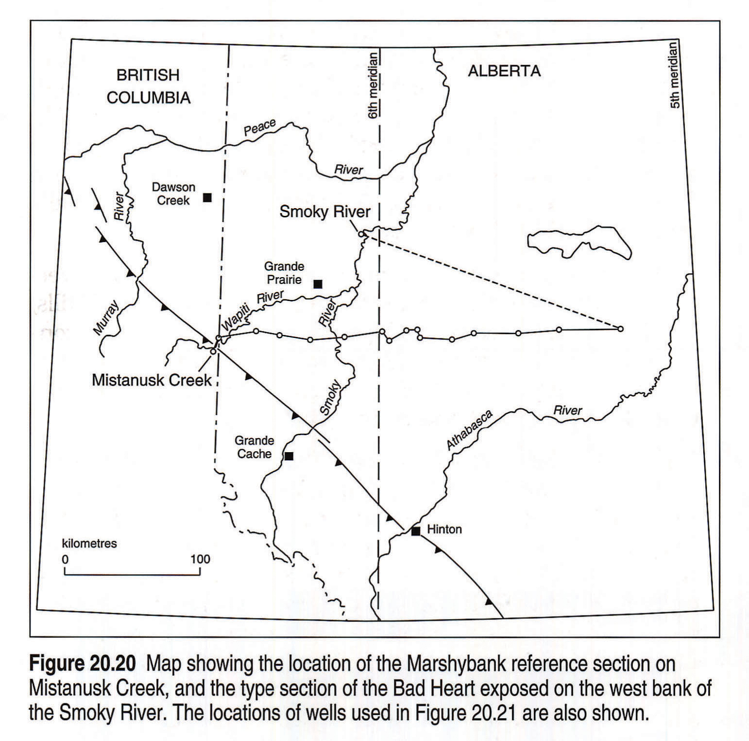
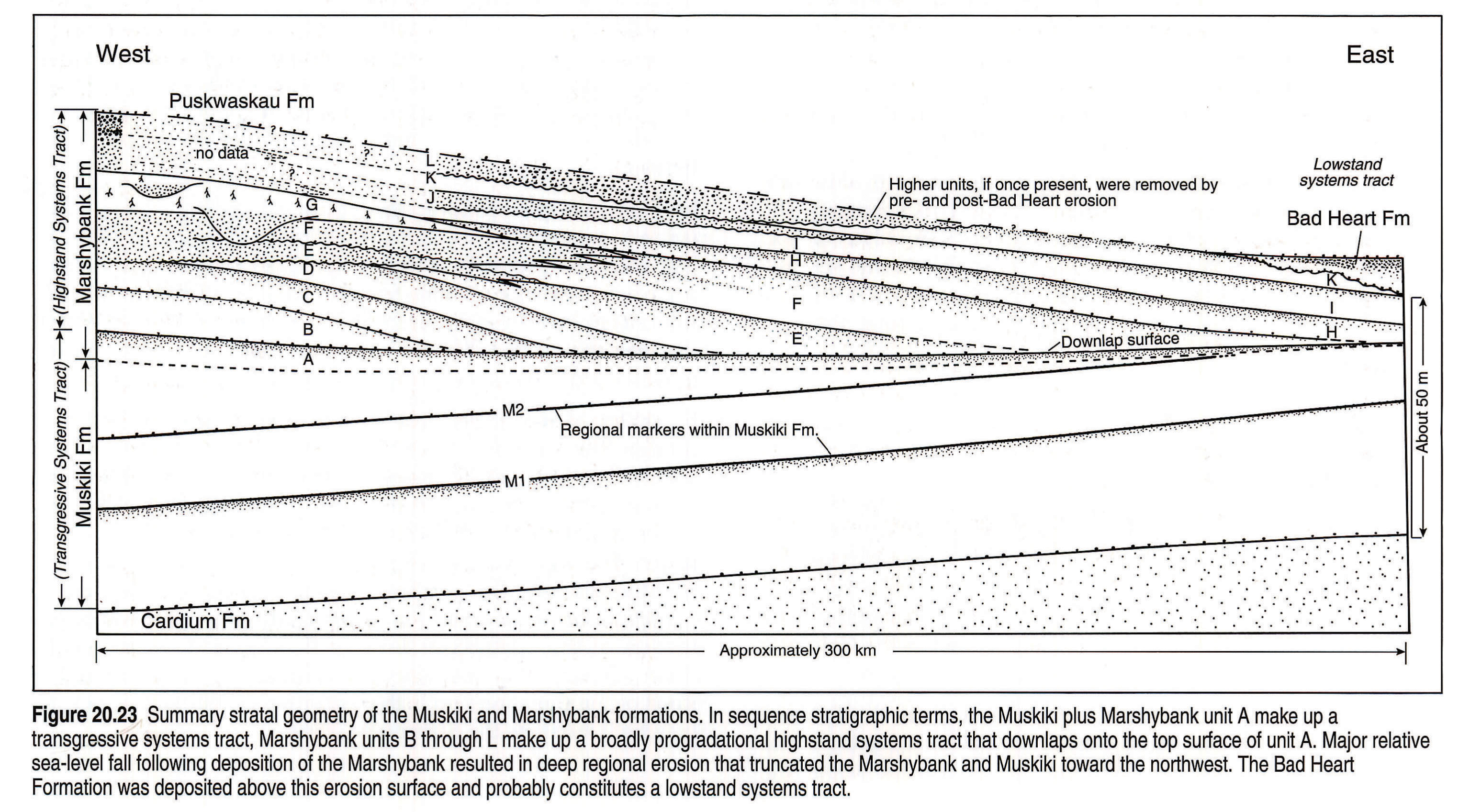
The type locality of the Bad Heart Formation was defined by McLearn (1919) at the junction of the Smoky and Bad Heart rivers (in the northern plains of Alberta; Fig. 20.20). McLearn (1919) described the Bad Heart sandstone as "10 - 25 feet of coarse sandstone, weathering reddish brown". Plint and Walker (1987) documented a regional unconformity at the top of the Marshybank (then termed the 'Bad Heart') which extended several hundreds of kilometres into the basin, and marked a period of erosion in response to relative sea-level fall. This unconformity also marked the base of the Bad Heart Formation in the Alberta Plains (Plint et al. 1990).
The Bad Heart Formation has been redefined (Plint et al., 1990) as a unit comprising fine-grained, silty sandstones containing abundant ooliths and areally restricted to the Alberta Plains. The older portion has been reassigned to the Marshybank Formation, which comprises non-oolitic, marine shelf and coastal plain sandstones and siltstones in the foothills and adjacent subsurface. It includes rocks formerly included in the Bad Heart Formation.
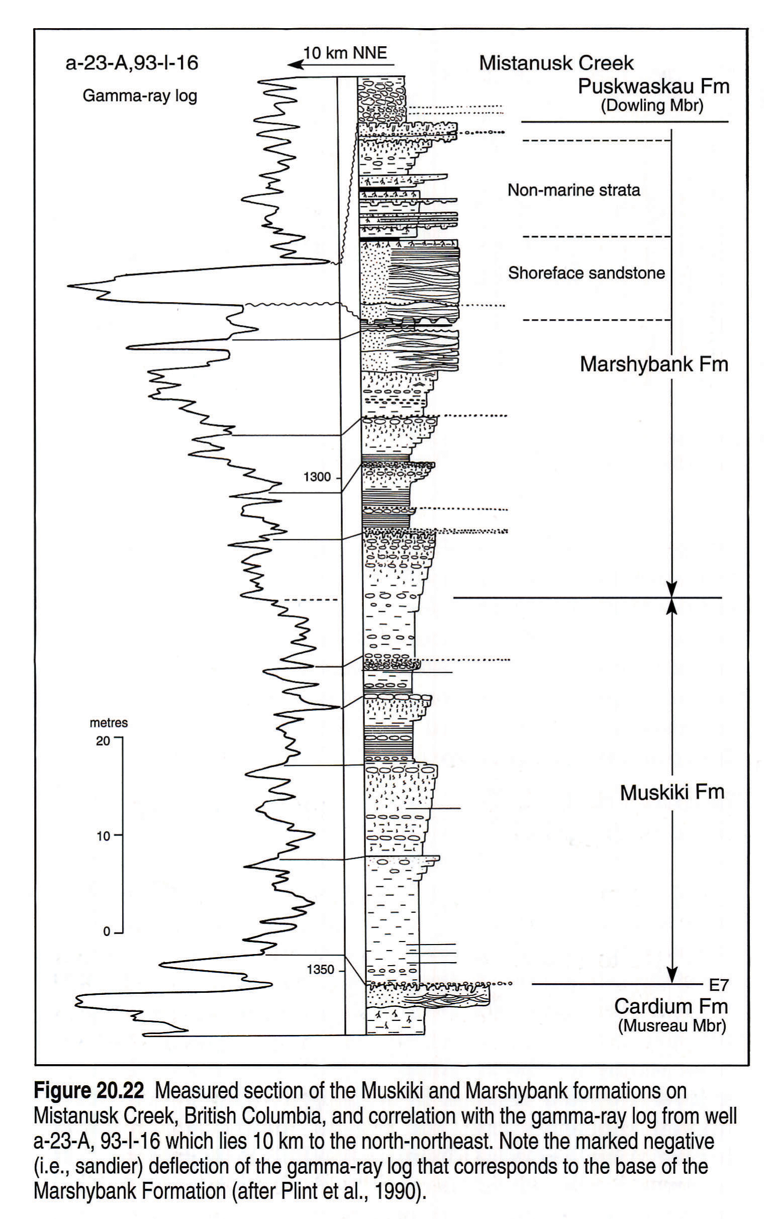
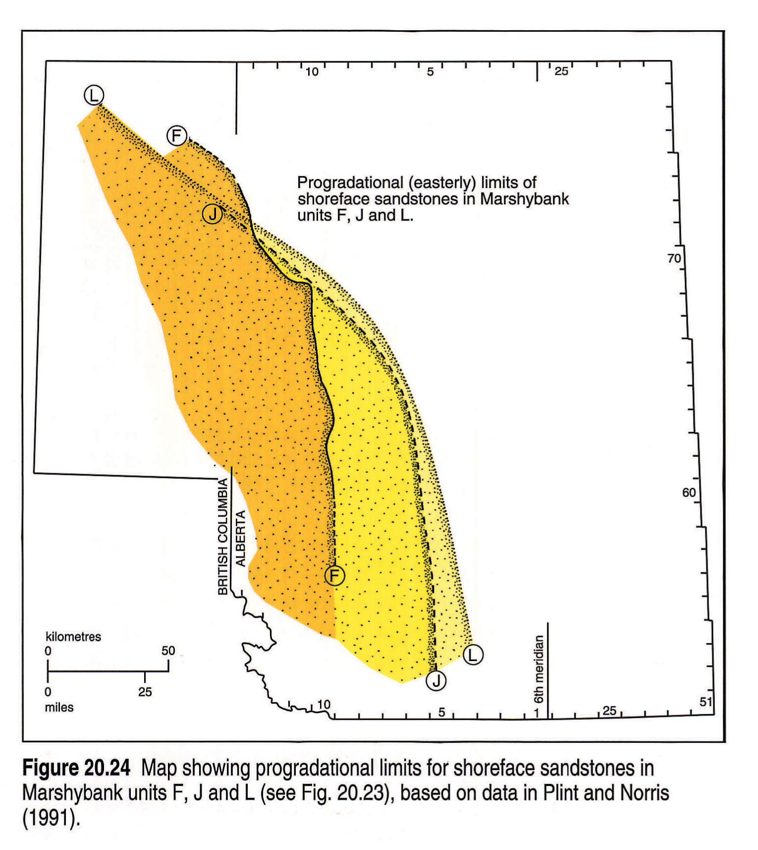
Figure 20.21 shows a detailed cross section extending from the foothills of British Columbia eastward into the plains of Alberta, which illustrates the unconformity. The cross section shows the dramatic thinning of the Marshybank Formation in a basinward direction, as a result of erosional truncation, and the eventual disappearance of sandstone (e.g., in 3-30-67-26W5). The Mistanusk Creek outcrop (Fig. 20.20) is the principal reference section for the Marshybank Formation and can be tied to the subsurface using a nearby well (Fig. 20.22). The Marshybank comprises upward-coarsening marine sequences that grade into a series of fine-grained, hummocky and swaley crossbedded and parallel-bedded shoreline sandstones, commonly overlain by coastal plain coals and fluvial units. The Marshybank paleogeography is characterized by northeast- to southwest-trending shorelines (Fig 20.24).
Farther basinward, sandstones of the Bad Heart Formation abruptly appear east of a northwest-trending line. The top of the Marshybank Formation is marked by a thin veneer of chert pebbles; this surface can be traced through the subsurface to the base of the Bad Heart Formation (Fig. 20.21). Detailed allostratigraphic outcrop and subsurface correlation of the Muskiki and Marshybank formations are summarized in Figure 20.23. Plint and Norris (1991) presented a detailed facies and paleogeographic analysis of the Muskiki and Marshybank formations. The Marshybank is made up of a series of upward-coarsening, dominantly mudstone and siltstone parasequences, many of which are capped by a pebble bed or an erosive-based shoreface sandbody. Integration of outcrop paleocurrent data with log-determined facies distributions allows former shoreline trends to be determined (Fig 20.24).
First White Speckled Shale/Niobrara Formation
The First White Speckled Shale is the informal name for a calcareous mudstone with subordinate amounts of bentonite, fish remains, nodular phosphate, and concretions of siderite and calcite. It is the upper of two white-speckled units that occur across the whole basin (Figs. 20.1, 20.5, 20.6, 20.7, 20.8, 20.9, 20.10). The thickness of the First White Speckled Shale is highly variable, ranging from 6 to 157 m. In Saskatchewan, the First White Speckled Shale lies directly and unconformably on the Second White Speckled Shale. The First White Speckled Shale is represented in part by the Thistle Member of the Wapiabi Formation in the Rocky Mountain Foothills and by the Niobrara Formation in the Manitoba Escarpment and southeastern Saskatchewan. The First White Speckled Shale occurs within the Labiche Formation in northeastern Alberta, in the Puskwaskau Formation in northwestern Alberta and in southern Alberta, within the Colorado Group.
On gamma-ray logs, the First White Speckled Shale interval is typically radioactive as a result of high uranium content associated with abundant kerogen. Discrete, radioactive spikes also occur as a result of bentonites deposited in the shales.
The Niobrara Formation (latest Turonian to earliest Campanian in age) in Manitoba is up to 73 m thick and consists of a lower calcareous shale succession overlain by chalky shale. A local to regional unconformity exists between the Niobrara and the overlying Pierre Formation; the break is less pronounced to the west (North and Caldwell, 1975; McNeil and Caldwell, 1981; McNeil, 1984). The three lowest members (Gammon Ferruginous Member, Pembina and Millwood members) of the Pierre Formation are correlative with the uppermost Alberta Group to the west. The Gammon Ferruginous Shale is a bentonitic shale ranging from 5 to 50 m in thickness. The Pembina Member consists of 3 to 15 m of carbonaceous shale containing abundant bentonite beds overlain by a non-carbonaceous succession. The late Campanian Millwood Member consists of 30 to 150 m of shale containing abundant fossiliferous and nonfossiliferous calcareous concretions.
The Santonian Medicine Hat Formation (Warren, 1985), which occurs in southeastern Alberta and southwestern Saskatchewan below the First White Speckled Shale, consists of at least three upward-coarsening, very fine-grained sandstone and siltstone successions, 3 to 11 m thick, deposited in a shallow-marine shelf setting (Gilboy, 1987; Hankel et al., 1989). The formation is up to 60 m thick. The Medicine Hat Formation (Fig. 20.18d) forms a shallow-gas reservoir, the largest and oldest gas field in Canada, containing locally derived biogenic gas.
Milk River/Chungo
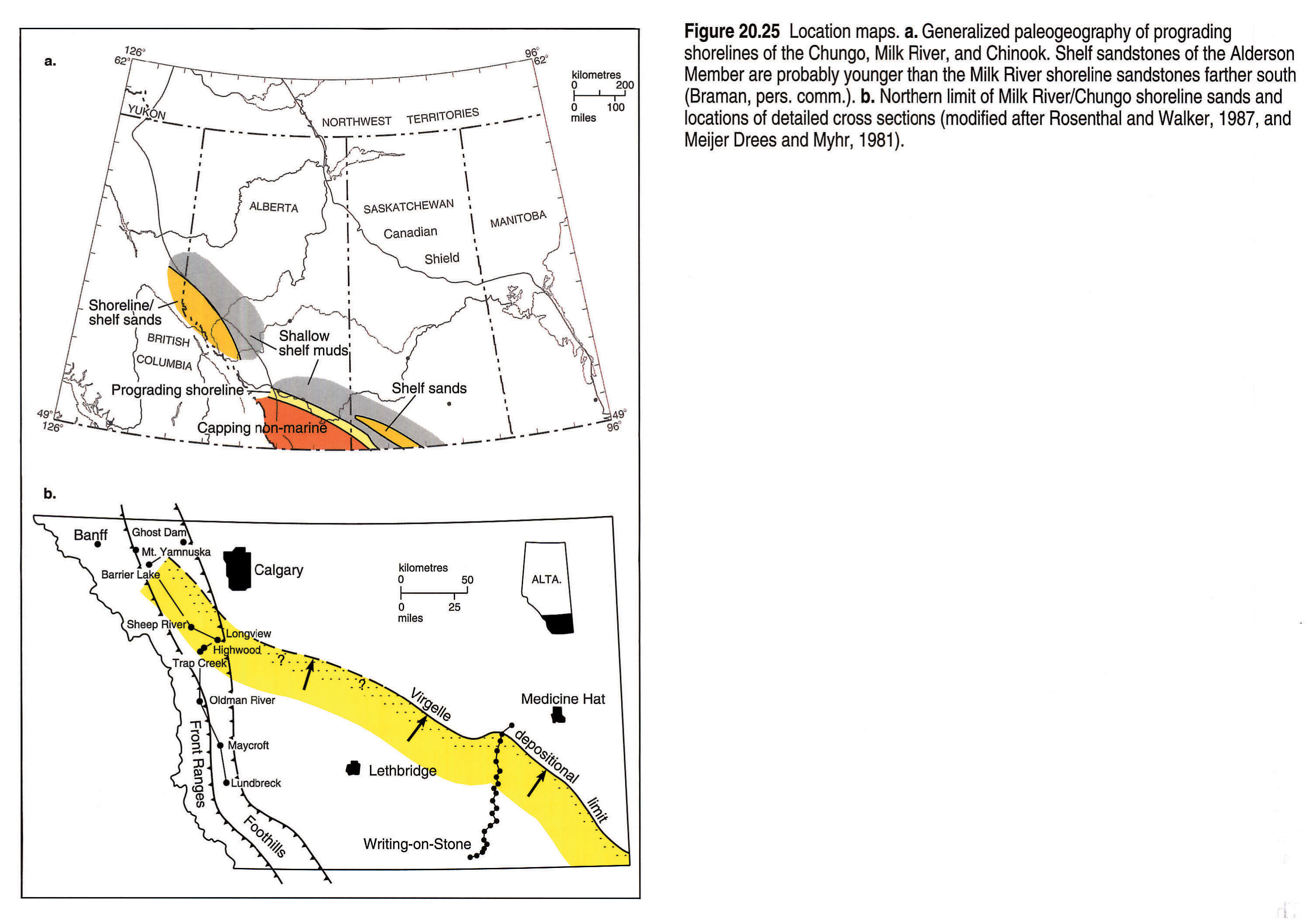
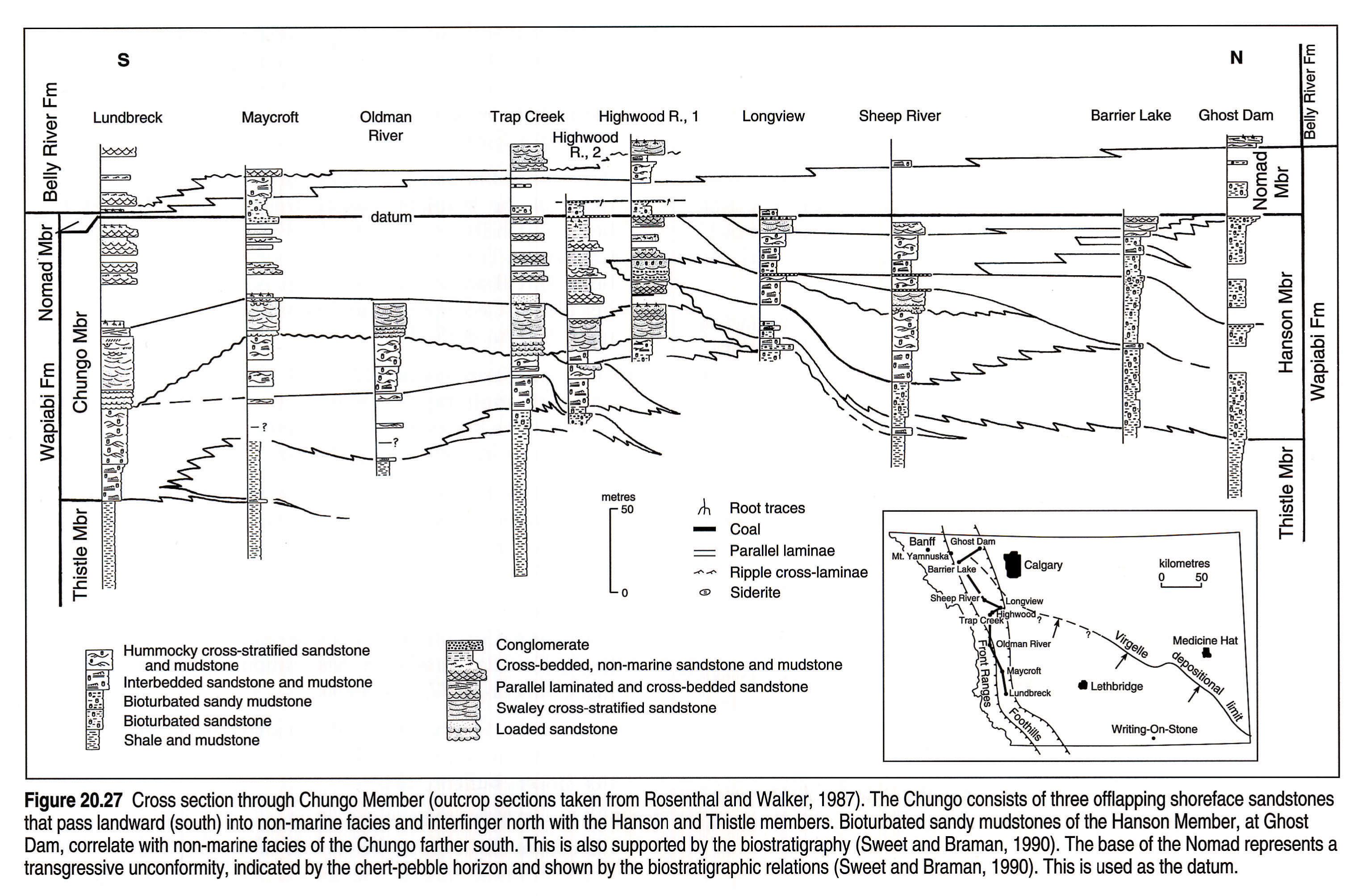
The early Campanian Milk River Formation (Fig 20.1) is a sandy clastic wedge confined to the plains of southern Alberta and Saskatchewan (Fig. 20.25) and the southern and central Rocky Mountain Foothills. The Milk River Formation occurs, in part, within the Alberta Group and within the Montana Group, but is not considered part of the Colorado Group. Sediments of the Milk River Formation are exposed in southern Alberta along the Milk River, as a result of uplift on the Sweetgrass Arch, but dip into the subsurface farther north where the formation passes into shales, siltstones, and sandstones of the Alderson Member of the Lea Park Formation (Fig. 20.26). The Alderson Member contains nearly 150 billion m3 of recoverable gas reserves in the "Milk River" gas pool (Meijer Drees and Myhr, 1981). It is dated at late Santonian to early Campanian in age (Sweet and Braman, 1990). In the foothills, the equivalent rocks are named the Chungo Member of the Wapiabi Formation. The older term Chinook sandstone has been used in the central foothills (Gleddie, 1949). In the southwest corner of Alberta the Nomad cannot be recognized and the Chungo has been included within the overlying Belly River Group (Stott, 1963; Dawson et al., this volume,Chapter 24).
The Milk River Formation is thought to be disconformably overlain by marine shales of the Pakowki Formation (Braman and Hills, 1990), the contact marked by a layer of chert pebbles. The disconformity can also be recognized in the foothills, where age-equivalent Nomad Member shales of the Wapiabi Formation overlie the Chungo Member (Sweet and Braman, 1990).
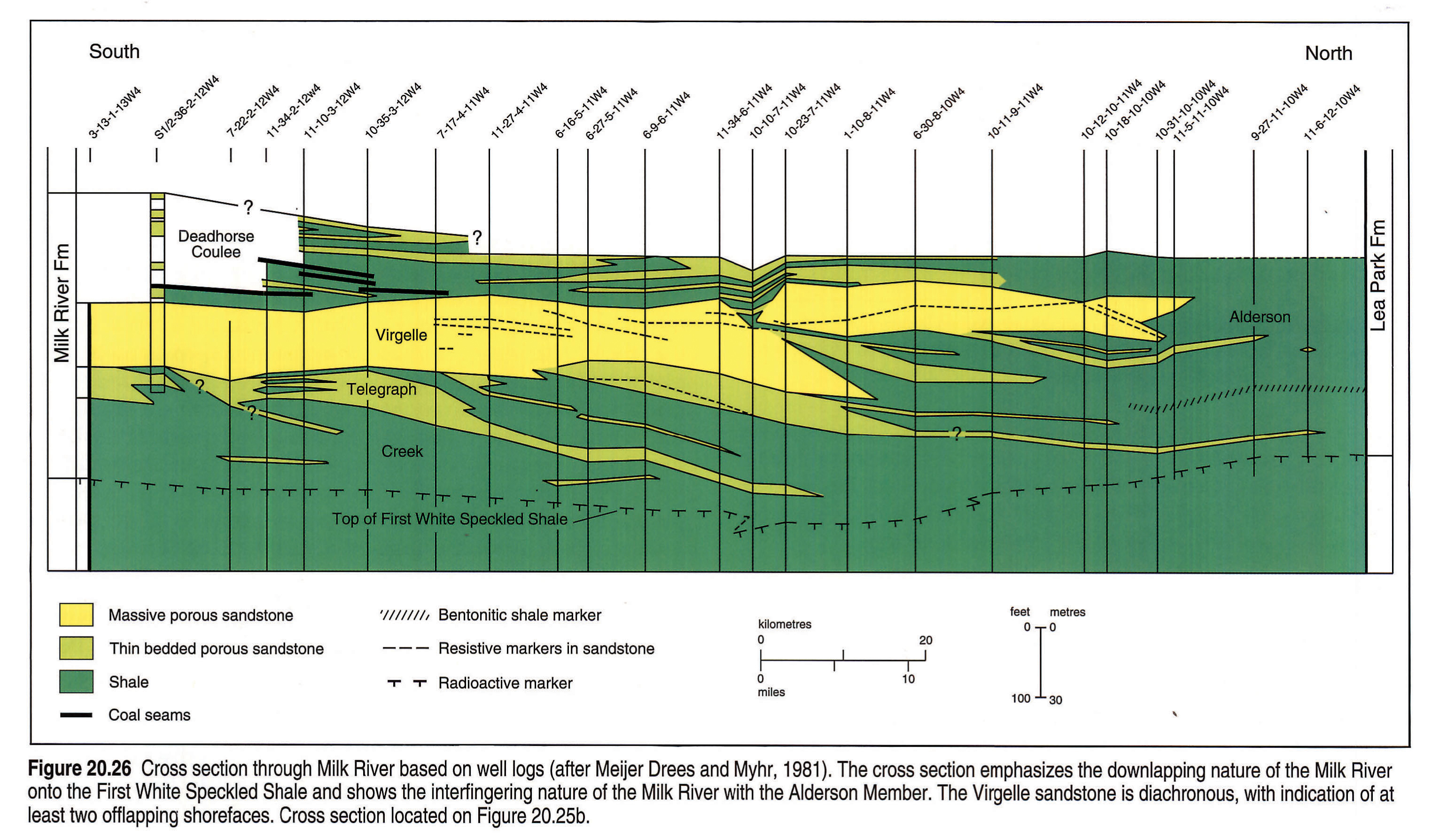
At Writing-On-Stone Provincial Park (Fig. 20.25), the Milk River Formation is about 100 m thick (Fig. 20.26) and has been subdivided into three members (Meijer Drees and Myhr, 1981). The lowermost Telegraph Creek Member comprises interbedded shales and sandstones that overlie the First White Speckled Shale. The Telegraph Creek grades up into the massive cliff-forming sandstone of the Virgelle Member. The Virgelle includes a lower unit interpreted as a storm-dominated shoreface sandstone (McCrory and Walker, 1986) and an upper unit, which has been interpreted as a tidal inlet complex (Cheel and Leckie, 1990). Paleocurrent data and general mapping indicates that paleoshorelines were oriented approximately east-west (Fig. 20.25). The overlying Deadhorse Coulee Member is a heterolithic coal-bearing unit (Fig. 20.26) interpreted as being of non-marine origin. The Milk River Formation passes basinward into bioturbated sandy mudstones of the subsurface Alderson Member, which is equivalent to the Hanson Member in outcrop.
Chungo Member outcrops have been described by Rosenthal et al. (1984) and Rosenthal and Walker (1987). A modified correlation of these outcrops is shown in Figure 20.27. The Chungo is interpreted as comprising a set of offlapping, shingled, coarsening-upward units (i.e., parasequences) capped by a widespread erosion surface marked by chert pebbles. In southwestern Alberta, the Chungo shoreface deposits interfinger southwestward with Chungo non-marine sediments and pass northward into the mudstones of the Hanson and Thistle members. Rosenthal et al. (1984) showed a similar relation with Chungo-equivalent Hanson Member mudstones farther north.
Meijer Drees and Myhr (1981) demonstrated that, in the subsurface (Fig. 20.26), parasequences in the equivalent Milk River Formation similarly downlap to the northeast onto a widespread, radioactive log marker coinciding with the top of the First White Speckled Shale, which probably represents a condensed section.
Re-evaluation of the age of the Chungo Member and its lithostratigraphic equivalents shows that it becomes younger to the northeast (Wall and Germundsun, 1963; Sweet and Braman, 1989, 1990). The unconformity between the Milk River/Chungo and the overlying marine shales of the Nomad/Pakowki, documented by Sweet and Braman (1990), suggests a different relation at the upper boundary than that indicated by Rosenthal and Walker (1987). The contact between Chungo and Nomad is sharp and unconformable (as suggested by Rosenthal et al., 1984), rather than interfingering. In the subsurface, this unconformity is shown as a prominent "shoulder" on sonic and resistivity well logs and has been used as a major stratigraphic datum for mapping purposes (Figs. 20.5, 20.6, 20.7, 20.8, 20.9, 20.10, 20.18 left pane, 20.18 right pane).
The duration and significance of the basal Pakowki unconformity apparently decreases northeastward, with sandy mudstones of the Alderson Member in Saskatchewan being late early to late Campanian in age (i.e., Pakowki equivalent, Braman, pers. comm.), rather than early Campanian. This is also supported by the offlapping geometries depicted in Figures 20.26 and 20.27.
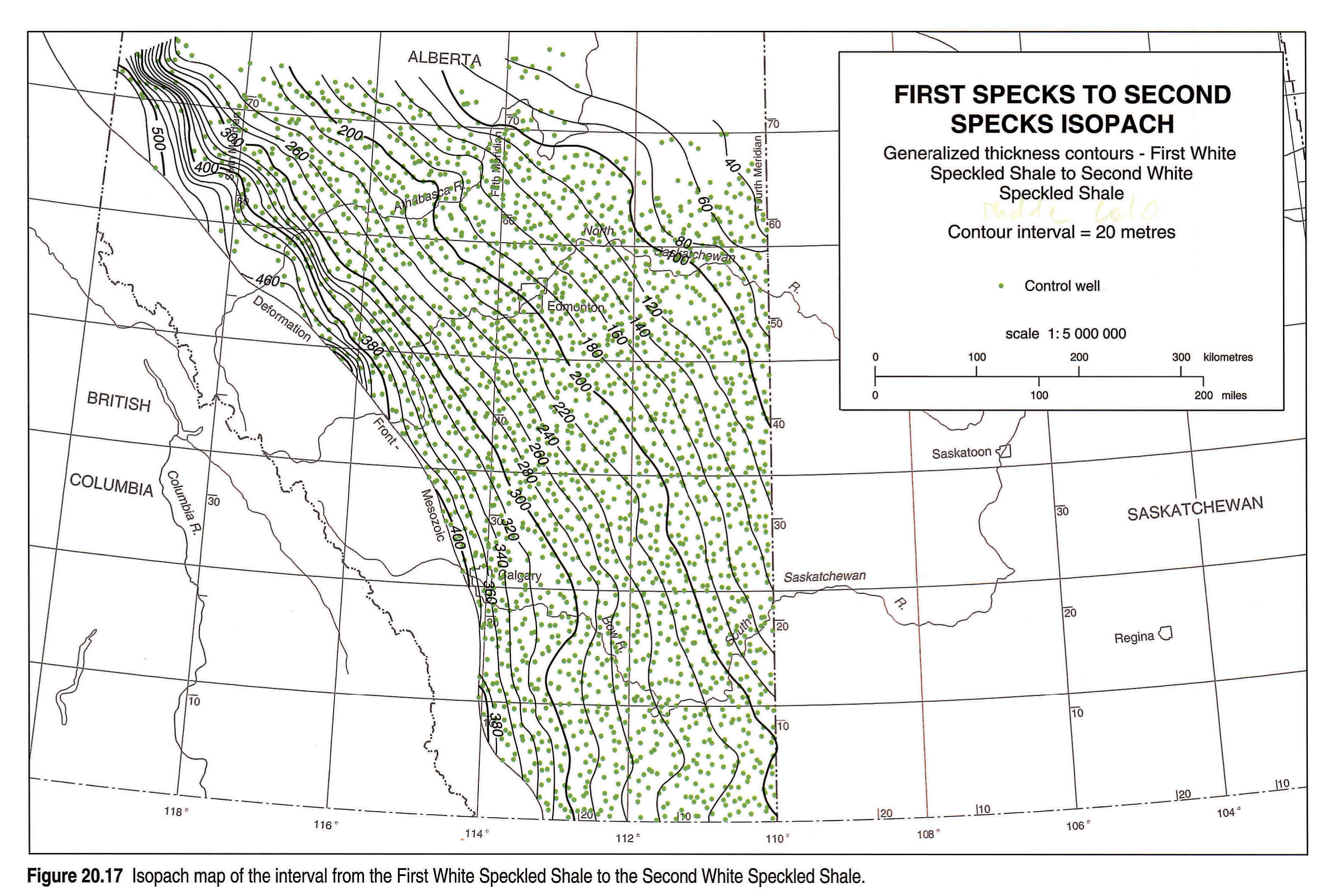
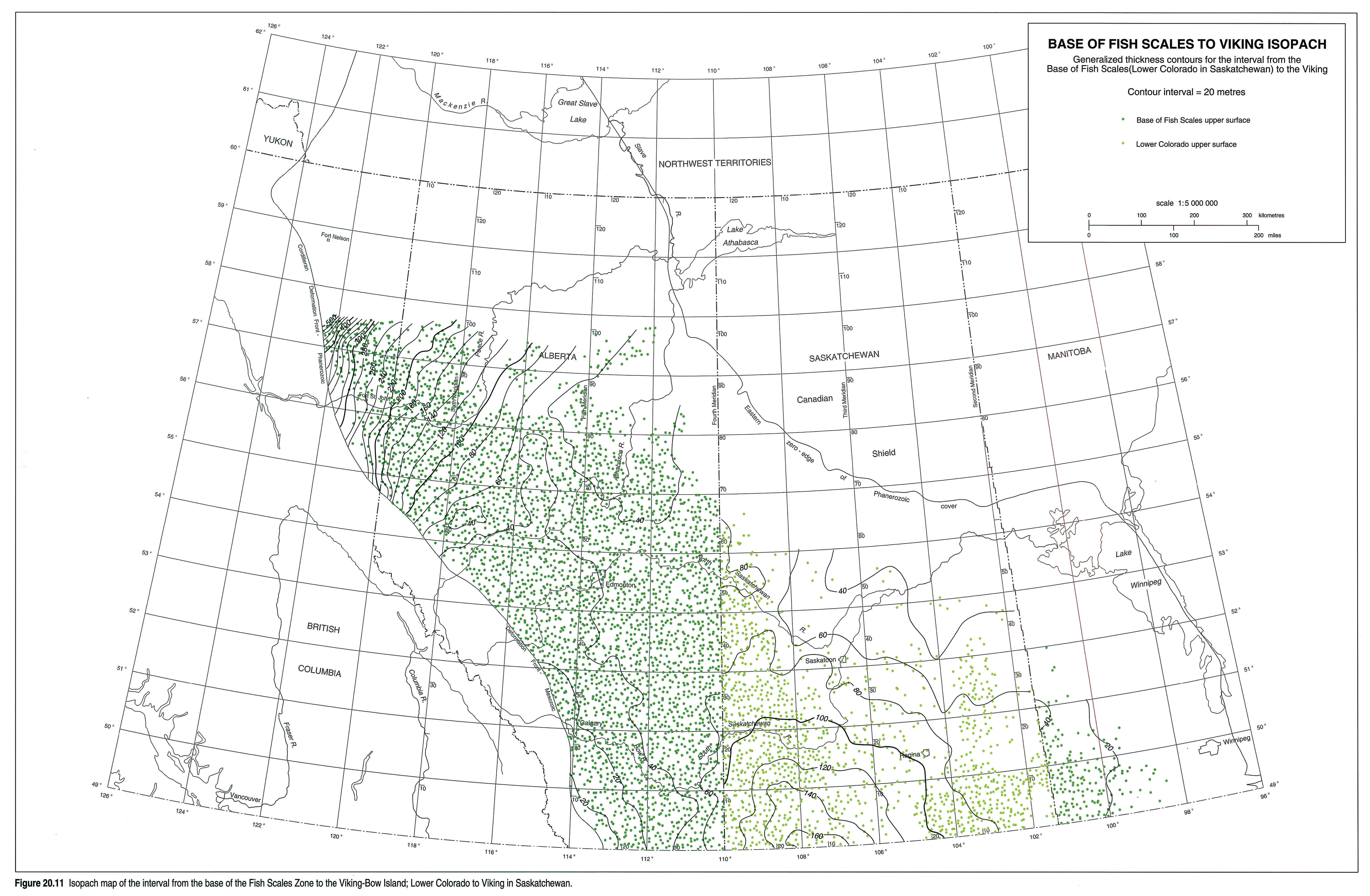
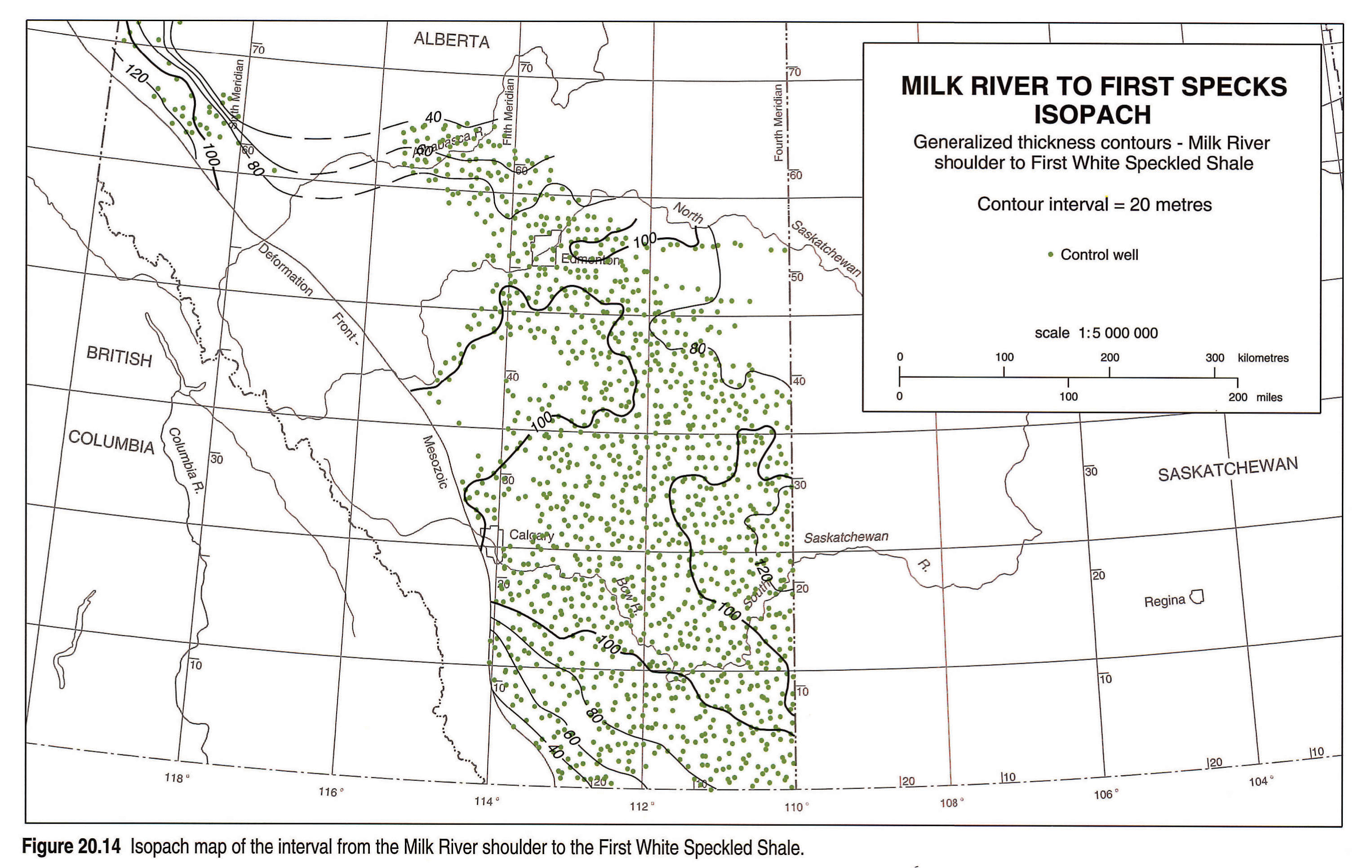
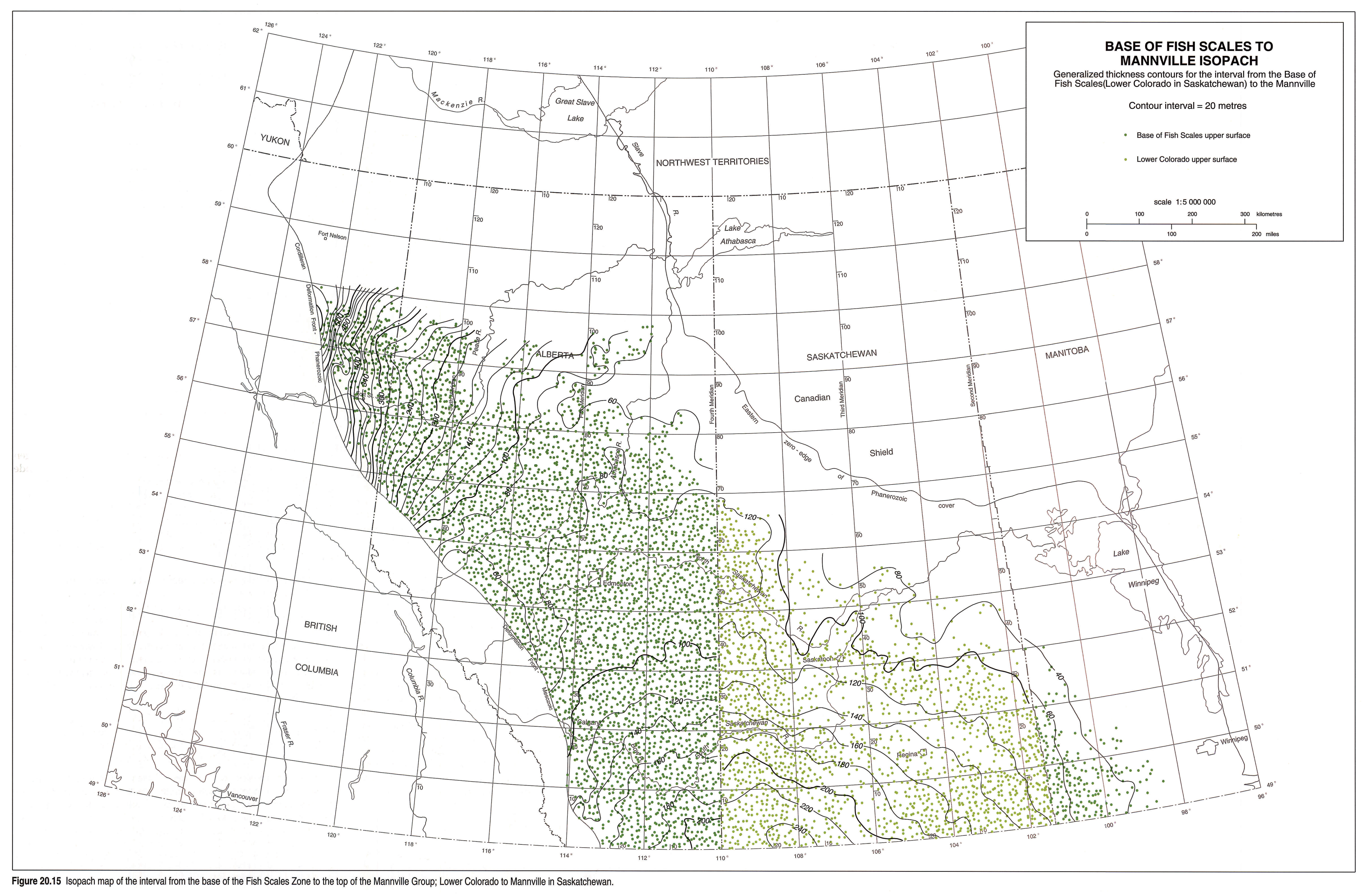
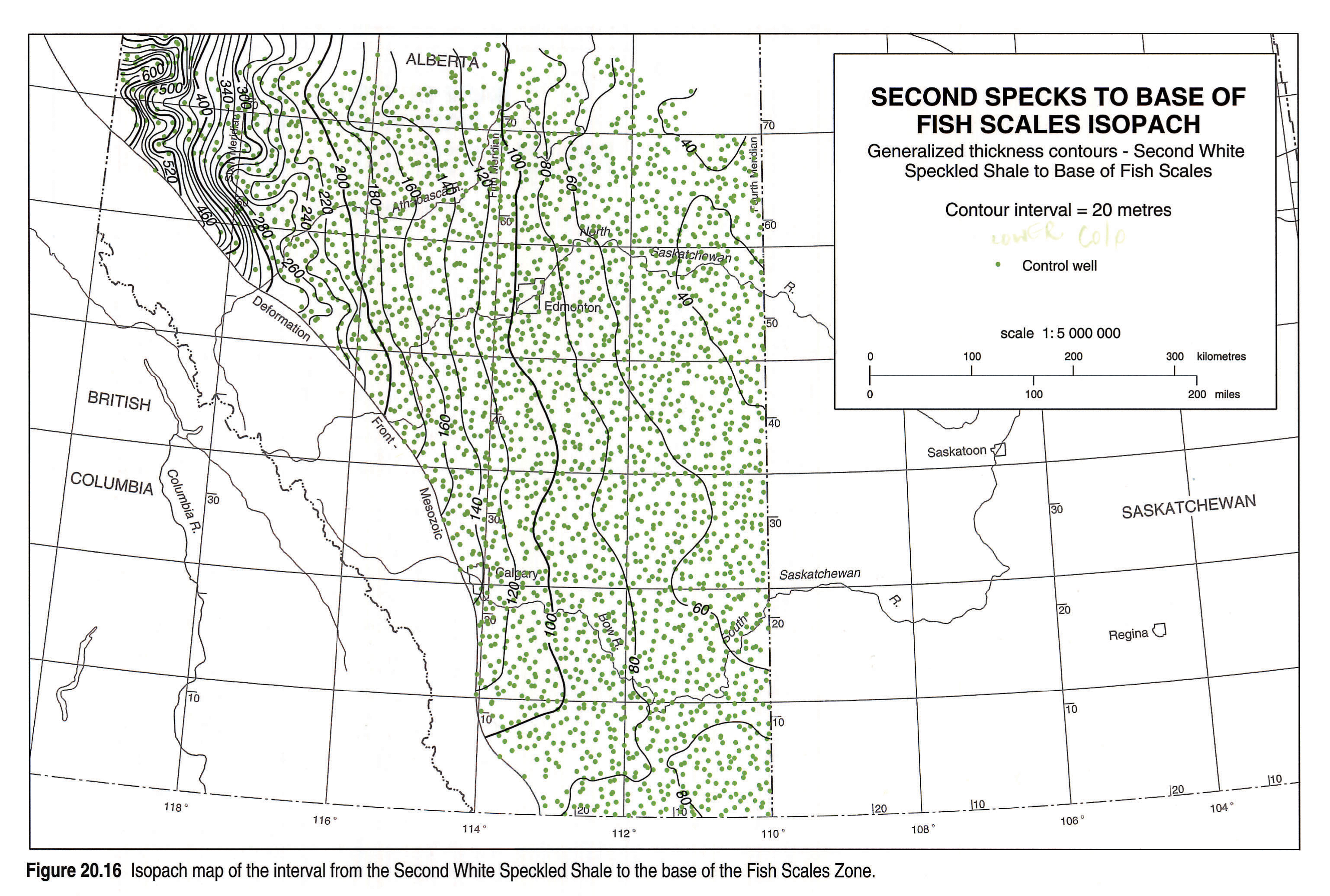
Isopach Maps
Isopach maps (Figs. 20.11, 20.12, 20.13, 20.14, 20.15, 20.16, 20.17) were constructed over stratigraphic intervals that were well constrained by consistent markers (maps of the Viking, Dunvegan and Cardium formations are shown in Chapters 21, 22 and 23, respectively). The maps show that over relatively short intervals of time, zones of maximum sediment accumulation shifted across the basin.
Maximum sediment thickness from the Base of Fish Scales to the top of the Viking Formation (Fig. 20.11) is found in northeastern British Columbia, thinning regularly from 400 to 60 m into northwestern Alberta. Throughout most of Alberta, the interval is 20 to 60 m thick. The region of thickest sediment approximately coincides with the position of Peace River Arch. The thinnest sediments occur adjacent to the Rocky Mountain Foothills in southwest Alberta where the Fish Scales Zone laps onto sediments of the Blairmore Group or was not deposited. The interval from the top of the Dunvegan Formation to the Base of Fish Scales (Fig. 22.3, this volume) is thickest (>>400 m) in northeastern British Columbia over the Peace River Arch and thins southeastward to 80 m in northwestern Alberta.
The isopach of Cardium to Second White Speckled Shale marker (Fig. 20.12) shows maximum thicknesses northwest of the Peace River Arch. A general westward thickening trend is marred by a few, isolated sections locally thicker. The interval from the First White Speckled Shale marker to the top of the Cardium Formation (Fig. 20.13) shows a general thickening to the southwest from 140 to 240 m. The uppermost isopach interval, from the top of the Milk River Formation to the First White Speckled Shale marker (Fig. 20.14) shows two depocentres: in the southwest, isopach values increase to a maximum of 150 m, whereas in the northwest, thicknesses of 110 m are attained.
Alternative isopach intervals, that include the entire Colorado Group of Alberta (Figs. 20.15, 20.16, 20.17), show regionally significant changes in sediment accumulation patterns for the period from the Albian to the Santonian, characterized by a shift in depositional strike from northeast-southwest to northwest-southeast.
Lithology of the Colorado Group Shales
The Lower Colorado Group shales, exclusive of the Joli Fou, form a wedge of marine sediments comprising dominantly mudstone and claystone (Fig. 20.28) with subordinate amounts of siltstone and fine-grained sandstone. Bentonites are common and increase toward the southwest. Sand and silt contents increase west-northwestward, reflecting the influence of more proximal prodelta and shelf environments. The shale is generally composed, in order of decreasing abundance, of mixed-layer illite/smectite, quartz, kaolinite, potassium feldspar, siderite and pyrite with minor muscovite, chlorite and biotite. The illite content of the mixed-layer clay increases to the west with increasing burial depth and diagenesis.
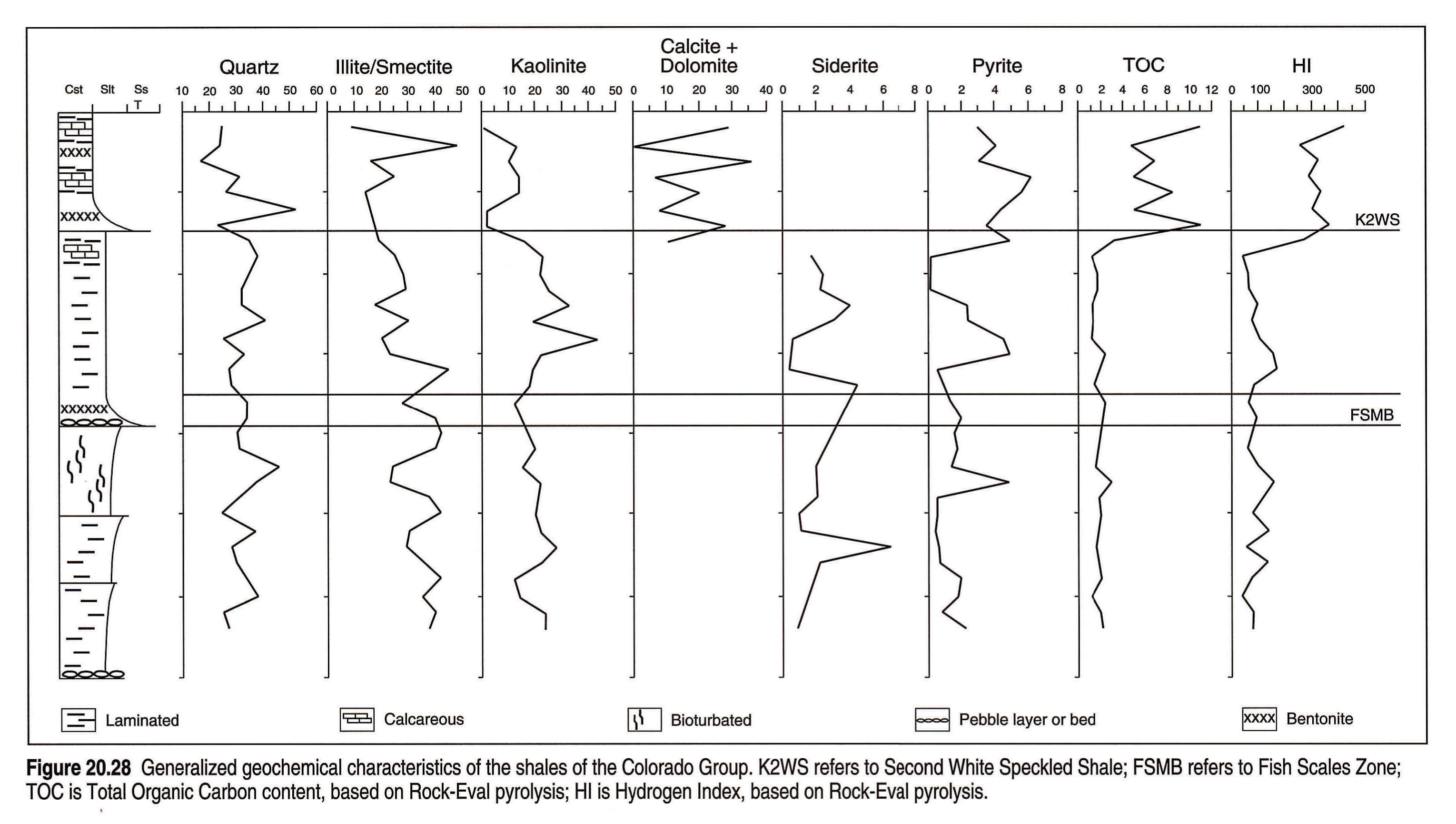
The basal beds of the Fish Scales Zone are similar in composition to the adjacent shales but contain coarser clastic detritus. Locally, total organic carbon (TOC) and Hydrogen Index (HI) values may be up to 6 wt percent and 400 mgHC/gOC, respectively.
The Second White Speckled Shale contains abundant marine (Type II) organic matter and is mineralogically distinct from the underlying Colorado Group shales. The Second White Speckled Shale is a calcareous mudstone to claystone containing up to approximately 38 wt percent calcite and/or dolomite with abundant pyrite (3 to 6 percent) and organic matter (4 to 11 wt percent). The calcite is largely bioclastic in origin, comprising Inoceramus, planktonic foraminiferal and nannofossil remains. The "white specks" are fecal pellets composed of nannofossil fragments. The silicate mineralogy is similar to that of adjacent Colorado Group shales.
Geological History
The Colorado Group represents sedimentation within the Western Canada Foreland Basin during a period when global sea level was generally high and rising, but interspersed with major higher frequency sea-level falls. Sedimentation took place within an active foreland basin, adjacent to a tectonically active hinterland. The erosional and depositional events preserved within the Colorado Group reflect this intermix of tectonic and eustatic controls.
The lowermost deposits of the Colorado Group are the Spinney Hill and Basal Colorado sandstones. These are related to the initial marine transgression of the Colorado Group over the Mannville Group. The overlying Joli Fou Formation contains marine faunal evidence of the first connection between the Gulf of Mexico and the colder waters of the Boreal seas from the Arctic. As such, the Joli Fou Formation represents the first Cretaceous seaway to extend the entire length of the Western Interior. The seaway may have been subsequently closed for part of Lower Colorado deposition and possibly even landlocked when the connections to the Gulf of Mexico and Boreal seas were closed (Williams and Stelck, 1975).
The coarser clastics of the Viking Formation are generally considered to be of shallow-marine origin and, in places, tidally influenced. Several sea-level lowstands may be represented in the Viking Formation, the major one dated at about 97 Ma. During these sea-level lowstands, incised valleys were cut and subsequently infilled with estuarine sediments during sea-level rise. One of the valleys now contains thick conglomerates of the Crystal Oil Field (Reinson et al., 1988). Southwest winds dispersed volcanic ash (bentonites) within the Joli Fou and Viking formations across southern Alberta (Amajor, 1985). In northern Alberta, a sea-level lowstand resulted in an incised valley system several hundred kilometres long, cut into the Middle Albian Cadotte Member, from the Rocky Mountain Foothills to the Interior Plains. This incised valley system is coeval with multiple paleosols in the Boulder Creek Formation in northern British Columbia (Leckie et al., 1989) and in the Mill Creek/Bow Island formations in southern Alberta. These paleosols formed when sedimentation rates on the floodplains decreased in the more westerly portions of the basin during lowstands. The subsequent sea-level rise deposited the estuarine, shallow-bay and shoreline deposits of the Paddy Member.
The volcanoes that produced the Upper Albian(?) Crowsnest Formation in southwest Alberta were surrounded by an inland flood plain and were probably of high relief. The magma chamber may have been a hydrous alkaline trachyte (Pearce, 1970) that resulted from crustal melting at about 25 to 35 km depth. Regional subsurface correlations show that the overlying Fish Scales Zone pinches out westward toward the Crowsnest Pass area (Fig. 20.7).
The shales of the uppermost Albian Shaftesbury Formation in northern Alberta and British Columbia represent sea-level rise and a major basinwide transgression above the Viking Formation and equivalent units. During this time, the Boreal sea connected for a second time with the northward-advancing seas from the Gulf of Mexico. The organic-rich Fish Scales Zone may represent the joining of the two seas. The Fish Scales Zone is generally considered to contain a condensed section deposited during a peak transgression of the Cretaceous Interior Seaway. It also marks the Albian/Cenomanian boundary. In southern Alberta, the oldest record of the transgression is the Cenomanian Blackstone Formation where it onlaps the Blairmore Group.
The Dunvegan Formation represents a major progradational event and a provenance in the Yukon Territory and northern British Columbia. The Dunvegan Formation consists of numerous stacked depositional cycles that prograded as wave, fluvial and mixed-influence deltas (Bhattacharya and Walker, 1991). The progradation, though attributed to global lowering of sea level at 94 Ma, also coincided with a major uplift in the Omineca and Intermontane belts.
The sea-level rise that began in the Late Albian and reached its peak during the early Turonian is inferred to be eustatic (Haq et al., 1987; Caldwell, 1984). It resulted in basin-wide deposition of the coccolithic Second White Speckled Shale (Vimy Member) within which the Cenomanian-Turonian boundary occurs (Stelck and Wall, 1954). The Second White Speckled Shale is represented by the argillaceous, highly calcareous Favel Formation in Manitoba (McNeil and Caldwell, 1981). The calcium carbonate content of this interval generally increases eastward away from the Cordillera.
During the Turonian, a major regression, in large part related to eustatic fall, resulted in a basin-wide disconformity and deposition of the non-marine to shelf sediments of the Cardium Formation. High-frequency fluctuations in sea level resulted in the complex depositional patterns now preserved.
The peak of the marine transgression following Cardium sedimentation is represented by the First White Speckled Shale. Planktonic faunas in this unit indicate a warm-temperate climate in at least the eastern part of the basin during the latest Cenomanian, Turonian and early Santonian to earliest Campanian (McNeil, 1984). During maximum marine transgressions, warm waters from the Gulf of Mexico possibly extended as far north as 54° N latitude, increasing water temperatures by up to 5° C to a temperature near 20° C (McNeil and Caldwell, 1981). In the First and Second White Specks and perhaps the Fish Scales Zone, the presence of biogenic chalk and planktonic foraminifera indicate open-marine conditions within the seaway during the peaks of the marine transgressions.
The final regressive event of the Colorado Group began during early Campanian time, and was culminated by extensive fine- to medium-grained shoreline sandstones of the overlying Virgelle Member (Milk River Formation) and the Chungo Member (Wapiabi Formation) which extend from southeastern Alberta and northern Montana to the central Alberta Foothills. The shoreline prograded as a sheet of wave-dominated sandstone up to 59 m thick; it extended along strike for at least 350 km. The Virgelle and Chungo members exposed in outcrop grade laterally northward into interbedded sandstone, siltstone and shale of the Alderson Member (of the Lea Park Formation) in the subsurface (Miejer Drees and Myhr, 1981; Rosenthal and Walker, 1987). In west-central Alberta, the shoreface sandstone of the Chinook Member is slightly younger than the Chungo Member, although Stott (1967) included the Chinook within the Chungo Member. The influence of tides in the foreland basin at this time is recorded in a tidal-inlet sequence preserved in outcrop at Writing-On-Stone Park in southern Alberta (Cheel and Leckie, 1990). During early to early late Campanian time, sea level rose again and the marine shales of the Pakowki Member/Nomad Member were deposited.
References
- Amajor, L.C. 1985. Biotite grain size distribution and source area of the Lower Cretaceous Viking bentonites, Alberta, Canada. Bulletin of Canadian Petroleum Geology, v. 33, p. 471-478.
- Banerjee, I. 1989. Tidal sandsheet origin of the transgressive Basal Colorado Sandstone (Albian): a subsurface study of the Cessford, southern Alberta. Bulletin of Canadian Petroleum Geology, v 37, p. 1-17.
- Bhattacharya, J. 1988. Autocyclic and allocyclic sequences in river- and wave-dominated deltaic sediments of the Upper Cretaceous Dunvegan Formation, Alberta: core examples. In: Sequences, Stratigraphy, Sedimentology: Surface and Subsurface. D.P. James and D.A. Leckie (eds.). Canadian Society of Petroleum Geologists, Memoir 15, p. 25-32.
- Bhattacharya, J.P. (this volume). Cretaceous Dunvegan Formation of the Western Canada Sedimentary Basin. In: Geological Atlas of the Western Canada Sedimentary Basin. G.D. Mossop and I. Shetsen (comps.). Calgary, Canadian Society of Petroleum Geologists and Alberta Research Council, chpt. 22.
- Bhattacharya J.P. and Posamentier, H.W. (this volume). Sequence stratigraphy and allostratigraphic applications in the Alberta foreland basin. In: Geological Atlas of the Western Canada Sedimentary Basin. G.D. Mossop and I. Shetsen (comps.). Calgary, Canadian Society of Petroleum Geologists and Alberta Research Council, chpt. 25.
- Bhattacharya, J. and Walker, R.G. 1991. Allostratigraphic subdivision of the Upper Cretaceous Dunvegan, Shaftesbury and Kaskapau formations in the northwestern Alberta subsurface. Bulletin of Canadian Petroleum Geology, v. 39, p. 145-164.
- Braman, D.R. and Hills, L.V. 1990. Overview of Campanian to Paleocene stratigraphy, southern Alberta foothills. In: Field guide to uppermost Cretaceous-Tertiary strata in southern Saskatchewan and Alberta. D.R. Braman and A.R. Sweet (eds.). Canadian Society of Petroleum Geologists 1990 Annual Convention, Basin Perspectives, Calgary, Alberta. p. 53-57.
- Caldwell, W.G.E. 1984. Early Cretaceous transgressions and regressions in the southern Interior Plains. In: The Mesozoic of Middle North America. D.F. Stott and D.J. Glass (eds.). Canadian Society of Petroleum Geologists Memoir 9, p. 173-203.
- Caldwell, W.G.E., North, B.R., Stelck, C.R., and Wall, J.H. 1978. A foraminiferal zonal scheme for the Cretaceous System in the Interior Plains of Canada. In: Western and Arctic Canadian Biostratigraphy. C.R. Stelck and B.D.E. Chatterton (eds.). Geological Association of Canada Special Paper 18, p. 495-575.
- Cant, D.J. 1988. Regional structure and development of the Peace River Arch, Alberta: a Paleozoic failed-rift system? Bulletin of Canadian Petroleum Geology, v. 36, p. 284-295.
- Cheel, R.J. and Leckie, D.A. 1990. A tidal-inlet complex in the Cretaceous epeiric sea of North America: Virgelle Member, Milk River Formation, southern Alberta, Canada. Sedimentology, v. 37, p. 67-81.
- Dawson, F.M., Evans, C.G., Marsh, R., and Richardson, R. (this volume). Uppermost Cretaceous and Tertiary strata of the Western Canada Sedimentary Basin. In: Geological Atlas of the Western Canada Sedimentary Basin. G.D. Mossop and I. Shetsen (comps.). Calgary, Canadian Society of Petroleum Geologists and Alberta Research Council, chpt. 24.
- Gilboy, C.F. 1987. Aspects of the regional geological framework of low-permeability shallow gas reservoirs in Upper Cretaceous strata (Colorado and Montana groups), southwestern Saskatchewan. Summary of Investigations 1987, Saskatchewan Geological Survey, Saskatchewan Energy and Mines, Miscellaneous Report 87-4, p. 199-213.
- Glass, D.J. (ed.) 1990. Lexicon of Canadian Stratigraphy, Volume 4, Western Canada. Calgary, Canadian Society of Petroleum Geologists, 772 p.
- Gleddie, J. 1949. Upper Cretaceous in western Peace River plains, Alberta. Bulletin of the American Association of Petroleum Geologists, v. 33, p. 511-532.
- Hankel, R.C., Davies, G.R., and Krouse, H.R. 1989. Eastern Medicine Hat gas field: a shallow, Upper Cretaceous, bacteriogenic gas reservoir of southeastern Alberta. Bulletin of Canadian Petroleum Geology, v. 37, p. 98-112.
- Haq, B.U., Hardenbol, J., and Vail, P.R. 1987. Chronology of fluctuating sea levels since the Triassic. Science, v. 235, p. 1156-1166.
- Jeletzky, J.A. 1971. Marine Cretaceous biotic provinces and paleogeography of western and Arctic Canada illustrated by a detailed study of ammonites. Geological Survey of Canada, Paper 70-22, 92 p.
- Kauffman, E.G. 1977. Geological and biological overview: Western Interior Cretaceous basin. Mountain Geologist, v. 14, p. 75-99.
- Krause, F.F., Deutsch, K.B., Joiner, S. D., Barclay, J.E., Hall, R.L., and Hills, L.V. (this volume). Cretaceous Cardium Formation of the Western Canada Sedimentary Basin. In: Geological Atlas of the Western Canada Sedimentary Basin. G.D. Mossop and I. Shetsen (comps.). Calgary, Canadian Society of Petroleum Geologists and Alberta Research Council, chpt. 23.
- Lambeck, K., Cloetingh, S., and McQueen, H. 1987. Intraplate stress and apparent changes in sea level: the basins of northwestern Europe: In: Sedimentary Basins and Basin-forming Mechanisms. C. Beaumont and A.J. Tankard (eds.). Canadian Society of Petroleum Geologists, Memoir 12, p. 259-268.
- Leckie, D.A., Fox, C., and Tornacai, C. 1989. Multiple paleosols of the late Albian Boulder Creek Formation, British Columbia, Canada. Sedimentology, v. 36, p. 307-323.
- Leckie, D.A. and Singh, C.R. 1991. Estuarine deposits of the Albian Paddy Member (Peace River Formation) and lowermost Shaftesbury Formation, Alberta, Canada. Journal of Sedimentary Petrology, v. 61, p. 825-849.
- Leckie, D.A., Staniland, M.R., and Hayes, B.J. 1990. Regional maps of the Albian Peace River and lower Shaftesbury formations on the Peace River Arch, northwestern Alberta and northeastern British Columbia. Bulletin of Canadian Petroleum Geology, v. 38A, p. 176-189.
- Leckie, D.A. and Smith, D.G. 1992. Regional setting, evolution and depositional cycles of the Western Canadian foreland basin. In: Foreland Basins and Fold Belts. R.W. Macqueen and D.A. Leckie (eds.). American Association of Petroleum Geologists, Memoir 55, p. 9-46.
- McCrory, V.L.C. and Walker, R.G. 1986. A storm and tidally-influenced prograding shoreline - Upper Cretaceous Milk River Formation of southern Alberta, Canada. Sedimentology, v. 33, p. 47-60.
- McLearn, F.H. 1919. Cretaceous, lower Smoky River, Alberta. Geological Survey of Canada, Summary Report, 1918, Part C, 52 p.
- McNeil, D.H. 1984. The eastern facies of the Cretaceous System in the Canadian Western Interior. In: The Mesozoic of Middle North America. D.F. Stott and D.J. Glass (eds.). Canadian Society of Petroleum Geologists, Memoir 9, p. 145-171.
- McNeil, D.H. and Caldwell, W.G.E. 1981. Cretaceous rocks and their foraminifera in the Manitoba Escarpment. Geological Association of Canada Special Paper 21, 439 p.
- Meijer Drees, N.C. and Myhr, D.W. 1981. The Upper Cretaceous Milk River and Lea Park formations in southeastern Alberta. Bulletin of Canadian Petroleum Geology, v. 29, p. 42-74.
- North, B.R. and Caldwell, W.G.E. 1975. Foraminifera from the Late Cretaceous System of Saskatchewan. In: The Cretaceous System in the Western Interior of North America. W.G.E. Caldwell (ed.). Geological Association of Canada, Special Paper 13, p. 303-331.
- Pearce, T.H. 1970. The analcite-bearing volcanic rocks of the Crowsnest Formation, Alberta. Canadian Journal of Earth Sciences, v. 7, p. 46-66.
- Plint, A.G. 1990. An allostratigraphic correlation of the Muskiki and Marshybank formations (Coniacian-Santonian) in the Foothills and subsurface of the Alberta Basin. Bulletin of Canadian Petroleum Geology, v. 38, p. 288-306.
- Plint, A.G. and Norris, B. 1991. Anatomy of a ramp margin sequence: facies successions, paleogeography and sediment dispersal patterns in the Muskiki and Marshybank formations, Alberta Foreland Basin. Bulletin of Canadian Petroleum Geology, v. 39, p. 18-42.
- Plint, A.G. and Walker, R.G. 1987. Morphology and origin of an erosion surface cut into the Bad Heart Formation during major sea-level change, Santonian of west-central Alberta, Canada. Journal of Sedimentary Petrology, v. 57, p. 639-650.
- Plint, A.G., Walker, R.G., and Duke, W.L. 1988. An outcrop to subsurface correlation of the Cardium Formation in Alberta. In: Sequences, Stratigraphy, Sedimentology: Surface and Subsurface. D.P. James and D.A. Leckie (eds.). Canadian Society of Petroleum Geologists, Memoir 15, p. 167-184.
- Plint, A.G., Norris, B., and Donaldson, W.S. 1990. Revised definitions for the Upper Cretaceous Bad Heart Formation and associated units in the Foothills and Plains of Alberta and British Columbia. Bulletin of Canadian Petroleum Geology, v. 38, p. 78-88.
- Podruski, J.A., Barclay, J.E., Hamblin, A.P., Lee, P.J., Osadetz, K.G., Proctor, R.M., and Taylor, G.C. 1988. Conventional oil reserves of Western Canada (light and medium). Geological Survey of Canada, Paper 87-26, 149 p.
- Porter, J.W. 1992. Oil and gas reserves of the Western Canada Foreland Basin. In: Foreland Basins and Fold Belts. R.W. Macqueen and D.A. Leckie (eds.). American Association of Petroleum Geologists, Memoir 55, p. 125-158.
- Reinson, G.E., Clark, J.E., and Foscolos, A.E. 1988. Reservoir geology of Crystal Viking Field, Lower Cretaceous estuarine tidal channel-bay complex, south-central Alberta. American Association of Petroleum Geologists, Bulletin, v. 72, p. 1270-1294.
- Reinson, G.E., Warters, W.J., Cox, J., and Price, P.R. (this volume). Cretaceous Viking Formation of the Western Canada Sedimentary Basin. In: Geological Atlas of the Western Canada Sedimentary Basin. G.D. Mossop and I. Shetsen (comps.). Calgary, Canadian Society of Petroleum Geologists and Alberta Research Council, chpt. 21.
- Rosenthal, L.R.P. and Walker, R.G. 1987. Lateral and vertical facies sequences in the Upper Cretaceous Chungo Member, Wapiabi Formation, southern Alberta. Canadian Journal of Earth Sciences, v. 24, p. 771-783.
- Rosenthal, L.R.P., Leckie, D.A., and Nadon, G. 1984. Depositional cycles and facies relationships within the Upper Cretaceous Wapiabi and Belly River formations of west-central Alberta. Calgary, Canadian Society of Petroleum Geologists, Field Trip Guide Book, 54 p.
- Rudkin, R.A. 1964. Lower Cretaceous. In: Geological History of Western Canada. R.G. McCrossan and R.P. Glaister (eds.). Calgary, Alberta Society of Petroleum Geologists, p. 56-158.
- Simpson, F. 1982. Sedimentology, palaeoecology and economic geology of Lower Colorado (Cretaceous) strata of west-central Saskatchewan. Saskatchewan Energy and Mines, Saskatchewan Geological Survey, Report 150, 183 p.
- Singh, C. 1983. Cenomanian microfloras of the Peace River area, northwestern Alberta. Alberta Research Council, Bulletin 44, 322 p.
- Slipper, S.E. 1918. Viking gas field, structure of the area. Geological Survey of Canada Summary Report 1917, Part C, p. 6-7.
- Stelck, C.R. and Armstrong, J. 1981. Neogastroplites from southern Alberta. Bulletin of Canadian Petroleum Geology, v. 29, p. 399-407.
- Stelck, C.R. and Wall, J.H. 1954. Kaskapau foraminifera from Peace River area of western Canada. Research Council of Alberta, Report 68, 81 p.
- Stott, D.F. 1963. The Cretaceous Alberta Group and equivalent rocks, Rocky Mountain Foothills, Alberta. Geological Survey of Canada, Memoir 317, 306 p.
- Stott, D.F. 1967. The Cretaceous Smoky Group, Rocky Mountain Foothills, Alberta and British Columbia. Geological Survey of Canada, Bulletin 132, 133 p.
- Stott, D.F. 1982. Lower Cretaceous Fort St. John Group and Upper Cretaceous Dunvegan Formation of the Foothills and Plains of Alberta, British Columbia, District of Mackenzie and Yukon Territory. Geological Survey of Canada, Bulletin 328, 124 p.
- Sweet, A.R. and Braman, D.R. 1989. A distinctive terrestrial palynofloral assemblage from the Lower Campanian Chungo Member, Wapiabi Formation, southwestern Alberta: a key to regional correlation. In: Contributions to Canadian Coal Geoscience. Geological Survey of Canada, Paper 89-8. p. 32-40.
- Sweet, A.R. and Braman, D.R. 1990. Age and stratigraphic significance of the Wapiabi-Brazeau transition, south-central Alberta Foothills and Plains. In: Field guide to uppermost Cretaceous-Tertiary strata in southern Saskatchewan and Alberta. D.R. Braman and A.R. Sweet (eds.). Canadian Society of Petroleum Geologists, Convention, Basin Perspectives, Calgary, Alberta. p.15-22.
- Wall, J.H. and Germundsun, R.K. 1963. Microfaunas, megafaunas, and rock-stratigraphic units in the Alberta Group (Cretaceous) of the Rocky Mountain Foothills. Bulletin of Canadian Petroleum Geology, v.11, p. 327-349.
- Wallace-Dudley, K. and Leckie, D.A. (in press). Sedimentology and source-rock potential of the lower Kaskapau Formation (Cenomanian-Turonian), northwestern Alberta, Canada. Geological Survey of Canada, Bulletin.
- Wallace-Dudley, K. and Leckie, D.A. 1993. The Lower Kaskapau Formation (Cenomanian): a retrogradational shelf system, Alberta, Canada. American Association of Petroleum Geologists, Bulletin, v. 77, p. 414-435.
- Warren, A. 1985. Southeastern Alberta shallow gas pools reserves and performance data. Alberta Energy Resources Conservation Board, Bulletin, 18 p.
- Wickenden, R.T.D. 1949. Some Cretaceous sections along the Athabasca River from the mouth of Calling River to below Grand Rapids, Alberta. Geological Survey of Canada, Paper 49-15, 31 p.
- Williams, G.D. and Burk, C.F. 1964. Upper Cretaceous. In: Geological History of Western Canada. R.G. McCrossan and R.P. Glaister (eds.). Alberta Society of Petroleum Geologists, p. 169-189.
- Williams, G.D. and Stelck, C.R. 1975. Speculations on the Cretaceous palaeogeography of North America. In: The Cretaceous System in the Western Interior of North America. W.G.E. Caldwell (ed.). Geological Association of Canada, Special Paper 13, p. 1-20.
- Wright, G.N., McMechan, M.E., and Potter, D.E.G. (this volume). Structure and architecture of the Western Canada Sedimentary Basin. In: Geological Atlas of the Western Canada Sedimentary Basin. G.D. Mossop and I. Shetsen (comps.). Calgary, Canadian Society of Petroleum Geologists and Alberta Research Council, chpt. 3.