Chapter 23 - Cretaceous Cardium Formation of the Western Canada Sedimentary Basin |
|
| Chapter Sections |
Table 23.2a Oil production from the Cardium |
Authors: F.F. Krause - The University of Calgary, Calgary
K.B. Deutsch - The University of Calgary, Calgary
S.D. Joiner - The University of Calgary, Calgary
J.E. Barclay - Geological Survey of Canada, Calgary
R.L. Hall - The University of Calgary, Calgary
L.V. Hills - The University of Calgary, Calgary
Overview and Geologic Framework
The Cardium Formation, exposed along the Rocky Mountain Foothills and present beneath the Alberta Plains, comprises a terrigenous, muddy, sandy, and conglomeratic clastic wedge that accumulated during the Turonian and Coniacian stages of the Late Cretaceous along the western margin of the Alberta Foreland Basin. This clastic wedge is a complex lithostratigraphic interval that contains multiple disconformities, paraconformities and diastems of variable regional extent. The formation is encased in a thick succession of black mudstones, the Blackstone/Kaskapau formations below and the Wapiabi/Muskiki formations above. All these formations comprise a sedimentary assemblage assigned throughout Alberta and British Columbia to the Smoky, Alberta, La Biche and Colorado groups.
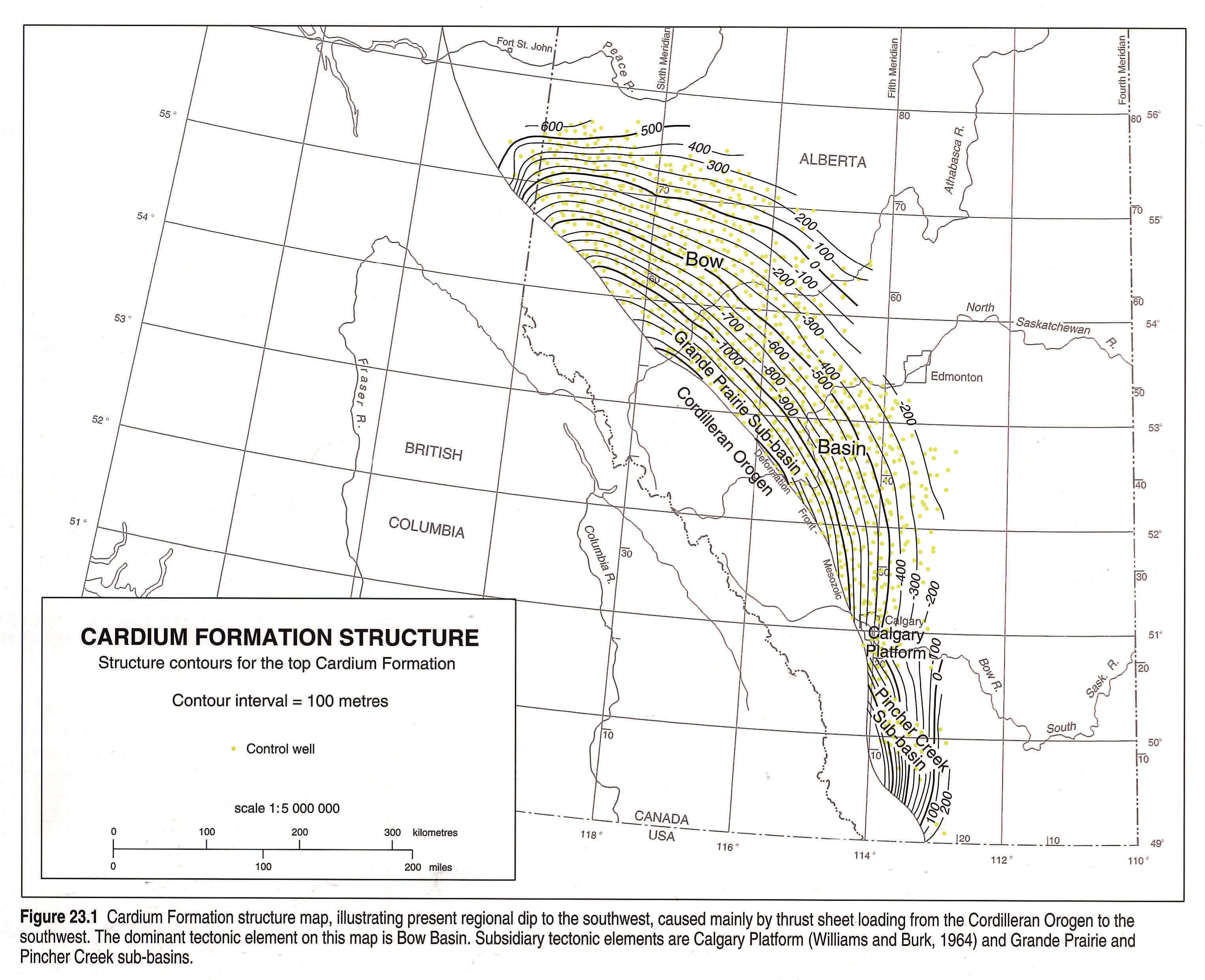
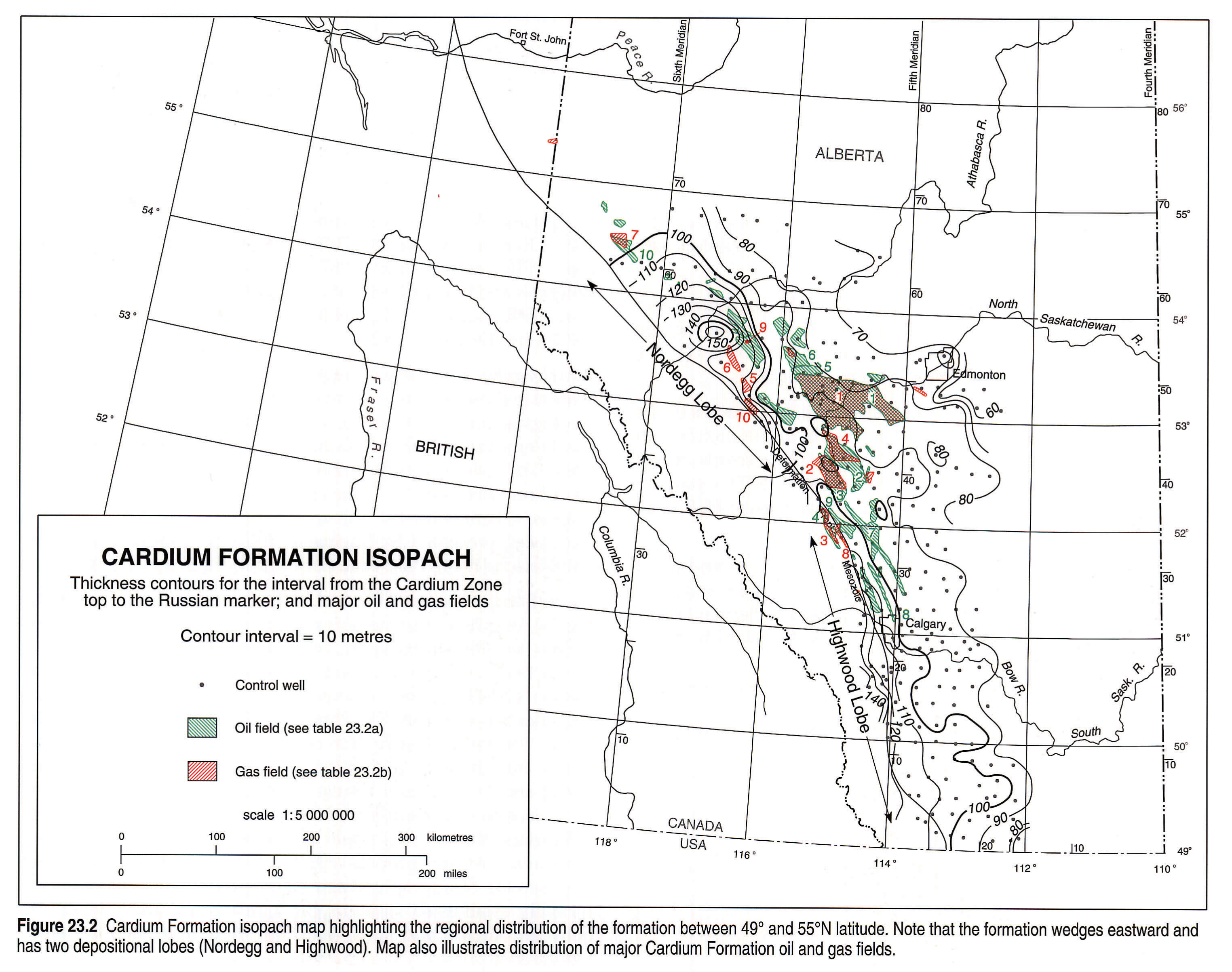
In plan view the formation is arranged in an arcuate strip, approximately 1000 km long, that swings through a 90 degree arc from Waterton Lakes National Park and Canada-U.S. border, past Grande Prairie, Alberta and beyond to Dawson Creek, British Columbia (Fig. 23.1). In the foothills, the formation has been brought to the surface by multiple, juxtaposed, east verging thrusts. In the plains it is confined to the subsurface within allochthonous and autochthonous intervals of the Colorado/ Alberta/Smoky/La Biche groups. The clastic wedge projects approximately 200 km into the basin's interior from the British Columbia-Alberta boundary, is 150 m thick in foothills exposures, thins in the subsurface of the plains to less than 50 m, and becomes indistinct along its easternmost terminus, melding into the mudstones (Fig. 23.2). The formation's dominant rock types are mudstone and sandstone, with small but important conglomerate fractions.
The Cardium Formation is of significant geological interest for two principal reasons: 1) it represents a complex stratotectonic pulse that alternated between sandy and muddy stages during the period of maximum inundation of the Mesozoic North American foreland basin, and 2) it possesses a colossal hydrocarbon storage capacity, manifest in a series of stratigraphic traps, the largest of which is the supergiant Pembina Field (Fig. 23.2) (Nielsen and Porter, 1984; Krause et al., 1987a, b).
Sedimentological responses identified within the formation indicate that accumulation took place in muddy and sandy inner and outer shelf, shoreface, lagoonal, tidal, estuarine and coastal plain settings. The deposits alternated between coarse- and fine-grained stages that were controlled by both autocyclic and allocyclic processes, such as delta avulsion, compaction-driven subsidence, tectonically-driven subsidence, tectonically-controlled sediment sources, and tectonic and eustatically controlled changes in sea level. These processes contributed to the development of a complex sedimentary mosaic containing varied and abundant stratigraphic traps and reservoirs. Hydrocarbons stored in these reservoirs appear to have been derived from neighboring rocks, and are typically light and sweet (Deroo et al., 1977; Creaney and Allan, 1992). Reservoirs have been found at depths ranging between 1200 and 2700 m.
Previous Work
Literature on the Cardium Formation and its hydrocarbon reservoirs is considerable, exceeding 400 references (see Krause et al., 1987a; Leggitt et al., 1992). This literature comprises an array of geological and engineering studies published in academic and trade journals, oil company submissions to Alberta's Energy Resources Conservation Board, Geological Survey of Canada reports and maps, and university theses and technical memoranda.
Engineering. The formation has been described in a variety of engineering studies. The following are of regional stratigraphic interest: Groeneveld (1964), Gillund (1969), Alpay (1972), Chakravorty et al. (1978), McLeod (1978), Purvis and Bober (1979), Krause and Collins (1984) (see Krause et al., 1987a, b for other references).
Geophysics. Geophysical studies considered here are of regional stratigraphic interest. These studies have established characteristic seismic reflection signatures for the formation, in the search for stratigraphic traps and the description of triangle zones; namely, those by Wren (1984), Slatt et al. (1987), Chappell (1989), MacKay (1991) and Nazar (1992).
Mineralogy and Diagenesis. Information on the diagenesis and mineralogy of the formation is sparse. Notable studies include Sinha (1970), Machemer (1984), Krause et al. (1987b), Staley (1987), Machemer and Hutcheon (1988) and Selim et al. (1990).
Paleontology. There are not many paleontological studies of the Cardium Formation and it has only been studied systematically in the past decade: Pemberton and Frey (1984) - trace fossils; Sweet and McIntyre (1988) - palynomorphs; Heise (1987) - palynomorphs; Vossler and Pemberton (1988) - trace fossils; Hall et al. (1991) - ammonites.
Sedimentology. Contributions to our present understanding of the Cardium Formation since the advent of modern sedimentological practices have been many. They include Berven (1966), Michaelis and Dixon (1969), Swagor et al. (1976), Griffith (1981), Wright and Walker (1981), Krause (1982), Walker (1983a, b, c; 1984; 1985), Krause and Nelson (1984, 1991), Krause et al. (1987b, in press), Plint and Walker (1987), Plint et al. (1987), Plint (1988), Bergman and Walker (1987), Walker and Eyles (1988, 1991), Leggitt et al. (1990), Joiner (1991), Keith (1985, 1991), Pattison and Walker (1992), and Deutsch (1992).
Stratigraphy. Extensive stratigraphic studies of the Cardium Formation in the subsurface and in outcrop, by the oil industry and the Geological Survey of Canada, followed the discovery of the supergiant Pembina oilfield in 1953 (Michaelis, 1957; Nielsen, 1957; Stott, 1963, 1967). More recently, regional characteristics of the formation have been discussed by Duke (1985) and Plint et al. (1988). Stratigraphic schemes for the subsurface and correlations to outcrop have been presented by Michaelis (1957), Swagor (1975), Krause and Nelson (1984), Plint et al. (1986, 1988), Hall et al. (in press).
As outlined in Figures 23.3a and 23.3b, three schemes for subdividing the formation into members are presently in use. Two classifications are lithostratigraphic, one proposed for outcrops by Stott (1963, 1967) and one designed for the subsurface by Krause and Nelson (1984). A third scheme is an informal allostratigraphic classification proposed by Plint et al. (1986, 1987, 1988). Significantly, this latter classification correlates outcrop with subsurface strata, but discards all previous proposals. Recently, Deutsch (1992) and Deutsch and Krause (1990) have shown that the Ram and Moosehound members of Stott (1963) can be extended to the subsurface, thus casting doubt on the need to eliminate previous work and confirming Stott's (1967) correlations into the subsurface (see also the Stratigraphy discussion below). Other previous and formally established stratigraphic intervals are also correlatable between outcrop and subsurface, but their stratigraphic characterization is presently under review.
Structure. Structural analysis of the formation has proceeded from a dual perspective: 1) mesoscale examination of the distribution and orientation of fractures in outcrop, notably by Muecke and Charlesworth (1966) and Barton (1983), and in the subsurface by McLeod (1978) and Bell and Gough (1981); and 2) macro- and mega-scale studies of outcrops in the foothills and subsurface of the plains, where the Cardium Formation can be used as a marker horizon. These studies have focused on geological mapping and on geometric characterization of imbricate and east-verging thrusts, horses and duplexes, and triangle zone thrusts and passive roof duplexes; e.g., Martin (1956), Irish (1965), Bally et al. (1966), Ollerenshaw (1966, 1968a,b, 1970, 1972a,b, 1974, 1976a,b, 1978), Teal (1983), MacKay (1991), Skuce et al. (1992).
Stratigraphy
Stratigraphic Nomenclature
Cardium member names were established for outcrops in the foothills of Alberta and British Columbia by Stott (1963, 1967). He recognized seven members: Ram, Kiska, Cardinal, Leyland, Sturrock, Moosehound and Baytree (Figure 23.3a). He identified the Moosehound and Baytree members as being of continental and coastal plain origin, the former containing predominantly coals, mudstones and sandstones, and the latter conglomerates. The Baytree Member conglomerates have recently been studied by Hart and Plint (1989), who indicate that they represent shoreface and beach deposits. In contrast, the Ram, Cardinal and Sturrock members are dominantly sandy, while the Kiska and Leyland members are predominantly shaly; all five are of marine nearshore and shoreface origin. Stott (1963, p. 61 and 73, and his Fig. 5) also noted, in north-south regional transects, that the Kiska, Cardinal, Leyland and Sturrock members "replaced" the Moosehound Member from south to north because of transgression and onlap (see Fig. 23.3a).
Two lithostratigraphic units characterize the Cardium Formation in the subsurface of central Alberta - the Pembina River Member below and the Cardium Zone Member above (Fig. 23.3b) (Krause and Nelson, 1984; Krause et al., 1987b). The Pembina River Member includes the informal Cardium "A" and "B" sandstones used by industry to designate, respectively, an upper and a lower producing zone. The Pembina River Member consists of one or more coarsening-upward sequences that grade from shales to sandstones and then to variably thick conglomerates. The Cardium Zone Member also comprises coarsening-upward sequences, but in contrast to the Pembina River Member contains predominantly shales with lesser amounts of fine-grained sandstone and conglomerate. Both members are marine sediments, having been molded by wave, tidal and geostrophic currents and reworked by the activities of euryhaline and stenohaline bottom-dwelling organisms (Krause and Nelson, 1984; Vossler and Pemberton, 1988; Keith, 1991; Krause and Nelson, 1991; Krause et al., in press).
The Pembina River Member comprises stacked, but offlapping, progradational parasequence sets and the Cardium Zone Member stacked retrogradational and progradational parasequence sets (Keith, 1985, 1991; Plint et al., 1988; Joiner, 1991; Deutsch, 1992). The basal part of the Cardium Zone Member is transgressive, onlapping erosional surfaces that truncate underlying Pembina River Member units. The middle and upper Cardium Zone Member units offlap and onlap each other (Deutsch, 1992).
As shown by Joiner (1991) in the Pembina Field area, the upper Pembina River Member sandstones represent an eastward prograding and clinoforming parasequence set formed during a period of relative sea-level fall. A similar stratigraphic relation was noted by Keith (1985, 1991) in the Willesden Green Field area. Pembina River Member progradational parasequences are truncated at their updip edge by a major transgressive, marine erosion surface that is overlain and underlain by conglomerates. This unconformity is regional in extent and was first mapped by Griffith (1981), Krause and Collins (1984) and Keith (1985), and questionably (see below) by Leggitt et al. (1990). Unconformities with similar stratigraphic relations have been noted in outcrop at various levels (e.g., Michaelis, 1957; Wright and Walker, 1981; Krause and Nelson, 1984; Duke, 1985; Plint et al., 1988), but it has been demonstrated only recently, using ammonite biostratigraphy, that the sandstone parasequences in the upper Pembina River Member are correlative with the Cardinal Member in outcrop (Fig. 23.3) (Hall et al., 1991). Thus, the unconformity at the top of the Cardinal Member may be equivalent to the one observed at the Pembina Field (Hall et al., 1991, in press; Joiner, 1991).
The Cardium Zone Member has been traced by Deutsch (1992) and Deutsch and Krause (1990, 1991) in the subsurface of the Kakwa area. In this area, marine shales of the Cardium Zone Member interfinger and interface with coastal plain shales of the Moosehound Member. These relations are interpreted as resulting from transgression, erosion and truncation of Moosehound Member units, unroofing in the hinterland of thick upper Paleozoic carbonate sequences, and sedimentation processes typically found along muddy shorelines and shelves (Heise, 1987; Krause et al., 1987b, 1992; Deutsch and Krause, 1991). An alternative interpretation of these relations is proposed by Plint et al. (1988, Figs. 1 and 2), who suggest instead that the juxtaposition of coastal plain and marine shales is unconformable, the result of a fall in relative sea level and subsequent subaerial exposure, fluvial erosion and development of lowstand, coarse-grained shoreline deposits. Subsequently, relative sea level rose, resulting in shoreface erosion and removal and basinward redistribution of coarse-grained sediments.
A second, informal, subsurface member subdivision and correlation scheme has evolved over the past decade using a mixture of allostratigraphic and lithostratigraphic concepts (see Fig. 23.3b), (Plint et al., 1986, 1987, 1988). In this scheme, two members are lithostratigraphic, the Kakwa and Musreau (equivalent to the Ram and Moosehound members of Stott, 1963, 1967), and twelve are allostratigraphic: Nosehill, Bickerdike, Waskahigan, Hornbeck, Burnstick, Raven River, Carrot Creek, Low Water, Karr, Dismal Rat, Amundson and Obstruction (the first seven are equivalent to the Pembina River Member and the last five are equivalent to the Cardium Zone Member of Krause and Nelson, 1984). Plint et al. (1987, 1988) proposed that their allostratigraphic members are separated by regional unconformities that developed in response to eustatic sea-level drops and widespread subaerial exposure of the shelf. More recently, Leggitt et al. (1990) and Walker and Eyles (1991) suggested that the unconformity separating the Raven River and Carrot Creek allomembers was formed by combined eustatic and tectonic controls. Plint et al. (1988) accept that these unconformities provide the opportunity for intraformational correlation. Published discussions and replies relating to the allostratigraphic subdivision and correlation scheme proposed by Plint et al. (1986, 1987) have been provided by Hayes and Smith (1987), Rine et al. (1987), and Plint et al. (1987). Recent work by Walker and Eyles (1991) and Pattison and Walker (1992) goes as far as to indicate that these unconformities are basinwide. The unconformities may be basinwide, but to date evidence to substantiate this proposal has not been unearthed. It is worth noting that the Cretaceous Western Interior Seaway, the basin in which the Cardium Formation was deposited, extended from the Gulf of Mexico to the Arctic Ocean during the Turonian and Coniacian (Williams and Burk, 1964; Williams and Stelck, 1975).
Stratigraphic History
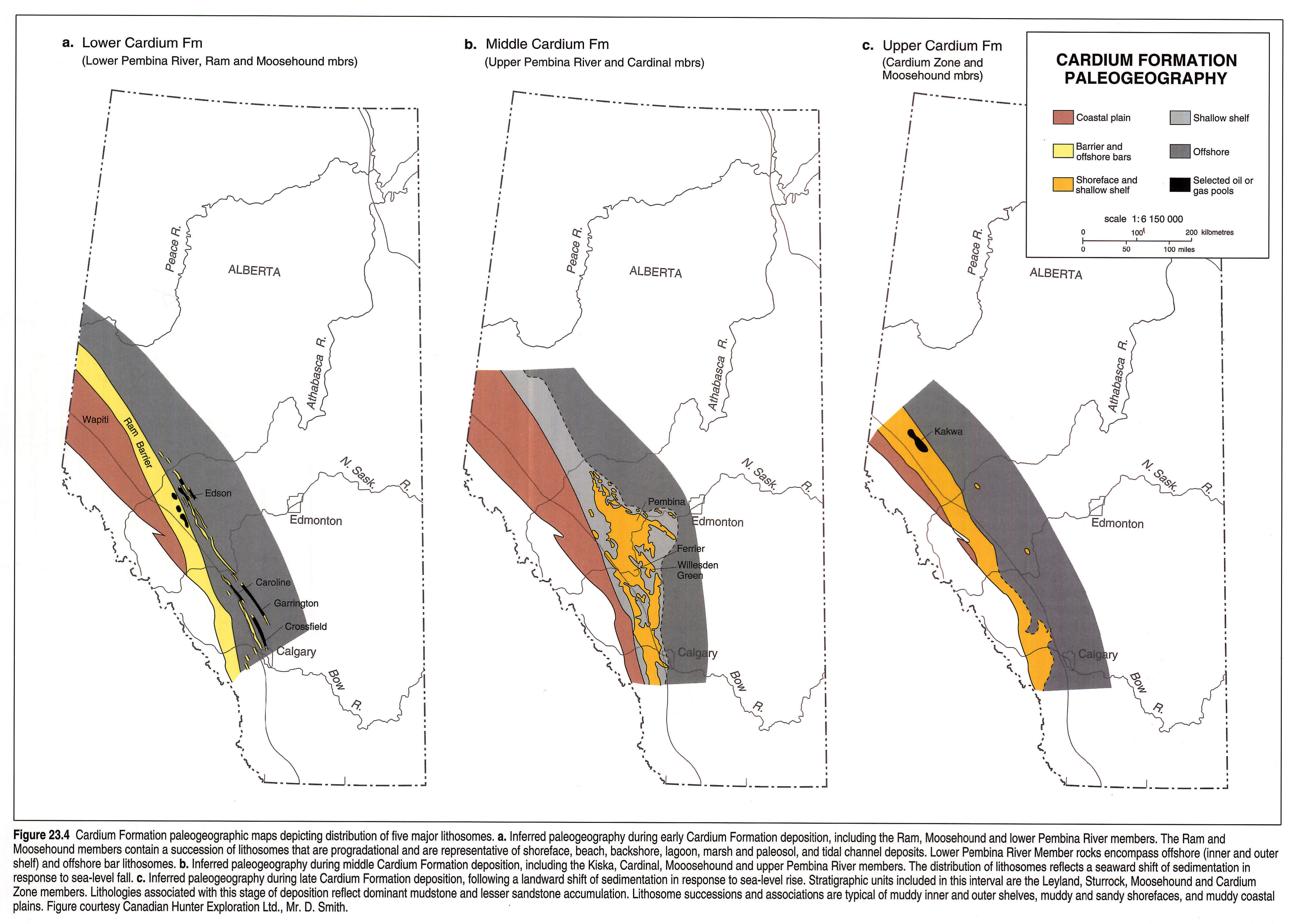
The depositional history of the Cardium Formation is summarized in three slice maps (Fig. 23.4), depicting paleogeography.
Ram, Moosehound and Lower Pembina River Members (Lower Cardium Formation). Initial Cardium Formation deposition (Fig. 23.4a) is represented by a progradational sedimentary assemblage (Ram and Moosehound members) marked predominantly by internal autocyclic discontinuities. Ram Member deposits are typified by extensive offshore, bioturbated and current-bedded mudstones that give way upward to crossbedded, shoreface, foreshore and tidal inlet sandstones of the "Ram Barrier", a prograding barrier island and strandplain system. In turn, "Ram Barrier" deposits are capped by mudstones and sandstones of backbarrier, lagoonal, tidal and coastal plain origin of the Moosehound Member (Stott, 1967; Duke, 1985; Plint, 1988; Plint and Walker, 1987; Deutsch and Krause, 1990, 1991; Deutsch, 1992). In front of the barrier island and strandplain system, to the east, are complexes of very long and narrow, northwest-southeast oriented, sandy and conglomeratic inner shelf ridges, sandwiched between bioturbated mudstones (Berven, 1966; Pattison, 1987; Krause and Nelson, 1991). Biostratigraphic data indicate that these ridges are younger than the Ram Member and older than the Cardinal Member (Heise, 1987). They may therefore have developed in a variety of ways: in response to relative sea-level fall, fluvial transport and complete modification during subsequent sea-level rise, as beach and shoreface deposits (Berven, 1966; Pattison and Walker, 1992); as offshore ridges along a muddy shoreline receiving fluvial input, but transported and reworked by tidal and storm currents, and subsequently decapitated and left stranded during sea-level rise (Krause and Nelson, 1991); or as tidal ridges (Off, 1963). Beyond the ridge complex, eastward and seaward, muddy outer shelf deposits dominate.
Upper Pembina River, Kiska, Cardinal and Moosehound Members (Middle Cardium Formation). The extensive sandy barrier island, strandplain and muddy lagoonal-coastal plain system that typified early Cardium Formation deposition gave way during middle Cardium deposition to muddy and sandy coastal plains and shelves (Fig. 23.4b). Both were widespread and contain significant estuarine, shoreface and inner shelf sandstones and conglomerates that accumulated in response to the lowering of relative sea level (Krause and Nelson, 1984; Keith, 1985, 1991; Krause et al., 1987b; Joiner, 1991). Typically, sandstones are overlain unconformably by conglomerates. Both deposits form an irregular and anastomosing sheet of variable thickness that has been mapped as a single unit across most of Alberta using resistivity logs and a 30 ohm m cut-off (Fig. 23.4b). Deposition of these sediments resulted in the sandstone and conglomerate reservoirs in the supergiant Pembina Field, and the Willesden Green, Ferrier, Ricinus, Carrot Creek and smaller fields (see Fig. 23.2). Sandstones in these fields are marine, prograde eastward and southeastward into the basin, and represent a response to lowered relative sea level (Krause et al., 1987b; Keith, 1985, 1991; Joiner, 1991). West of the hydrocarbon fields, mudstones, conglomeratic mudstones and fine-grained sandstones accumulated in marine, muddy, inner shelf, nearshore and swampy, coastal-plain settings. In contrast, thick conglomerate deposits accumulated in deep northwest-oriented scours cut into underlying sands and muds by repeated wave, storm and tidally induced currents. Scouring processes operated autocyclically during periods when relative sea level was stable and basin filling was taking place by progradation of sandstones. Subsequently, during rising relative sea level, scouring processes operated allocyclically as nearshore deposits were decapitated by transgression and modified by storm and inner and outer shelf processes (Swagor et al., 1976; Krause and Nelson, 1984; Joiner, 1991; Keith, 1991; Krause et al., in press). Scour and fill sediments accumulated in estuarine, shoreface and nearshore marine settings (Swagor et al., 1976; Krause et al., 1987b, in press; Bergman and Walker, 1987; Leggitt et al., 1990; Keith, 1991).
Cardium Zone, Leyland, Sturrock and Moosehound Members (Upper Cardium Formation). During late Cardium Formation deposition, the western margin of the foreland basin was characterized by extensive muddy coastal plain and shelf sedimentation along northwest-southeast oriented depositional belts (Fig. 23.4c). This style of sedimentation appears to have developed in response to extensive uplift and erosion of Devonian, Carboniferous and Permian limestone and dolostone strata in the orogenic wedge of the Mesozoic foreland. Support for this inference is provided by the almost exclusive occurrence of reworked palynomorphs of these ages in rocks of the Cardium Zone Member (Heise, 1987). In contrast, rocks of the Pembina River Member contain predominantly Permo-Triassic palynomorphs (Heise, 1987). These relations suggest that the stratigraphic order is inverted, perhaps as a result of progressive unroofing of the orogenic wedge (Deutsch, 1992; Krause et al., 1992). Thus, the supply of terrigenous material became restricted with time to very fine-grained sandstones, abundant muddy fractions and lesser cherty conglomerates. Fine-grained sandstones accumulated in lower and middle shoreface settings as inner shelf ridges, oriented northwest-southeast and offlapping to the northeast and southeast (Deutsch and Krause, 1990, 1991; Krause, 1990; Deutsch, 1992). Sandstones were imprinted predominantly by oscillatory current and bioturbate bedding, the latter represented typically by Cruziana and Skolithos ichnofacies (Deutsch, 1992).
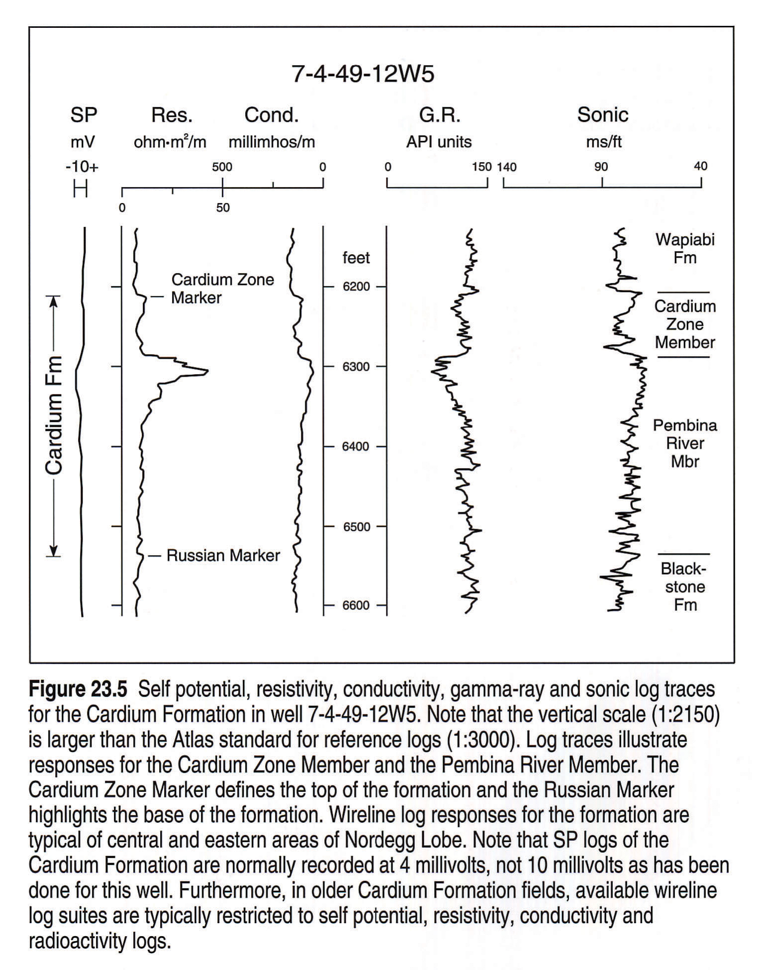
Reference Logs
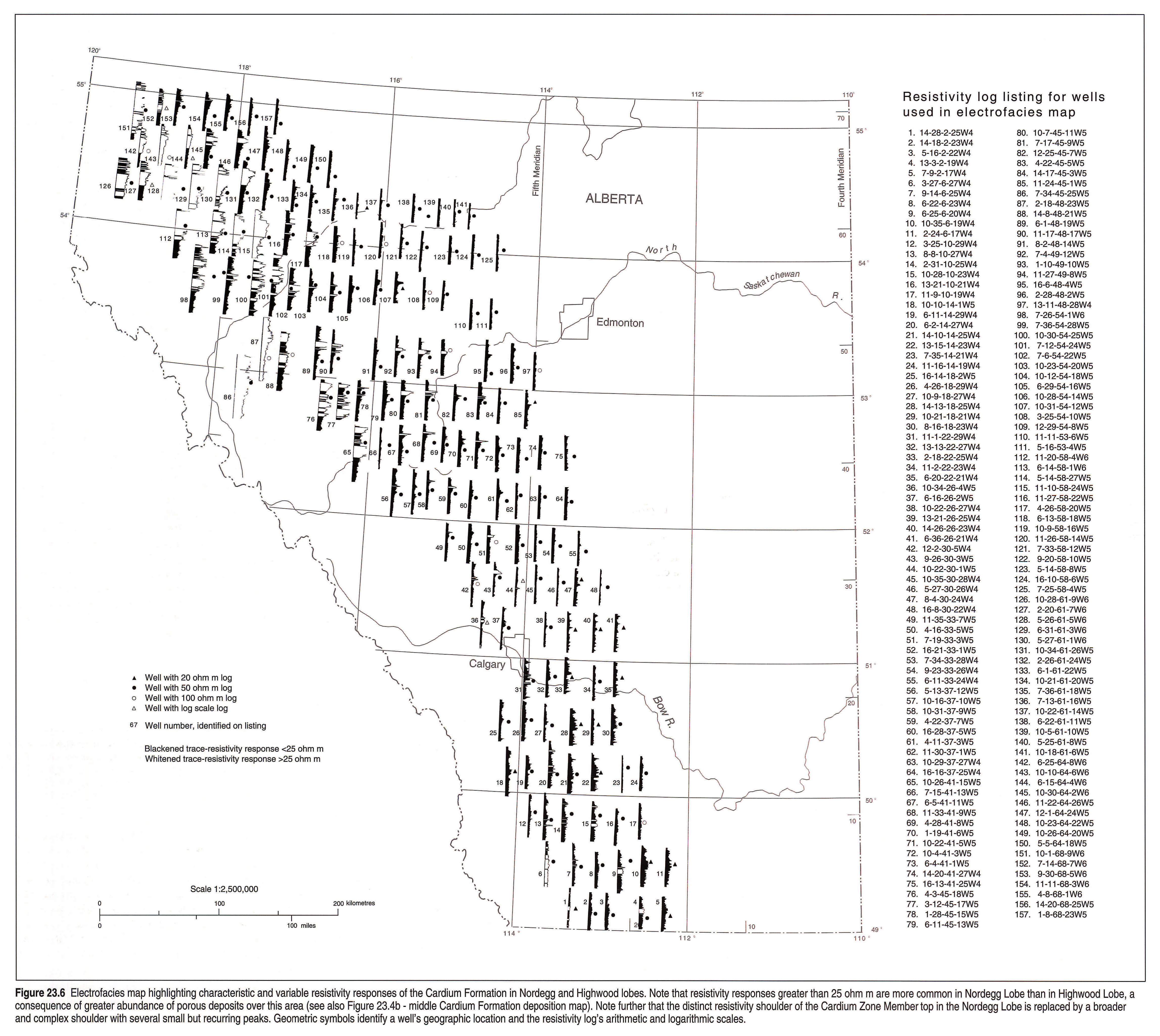
Characteristic Cardium Formation wireline log responses in Bow Basin are illustrated in Figures 23.5 and 23.6. Well 7-4-49-12W5 from the Pembina Field, which contains the most important Cardium Formation reservoir, illustrates a set of wireline tool records that includes gamma ray (G.R.) and sonic responses, in addition to the more commonly available spontaneous potential (SP), resistivity and conductivity log records (Fig. 23.5). The SP log in the reference well is not typical, having been logged at 10 milli-volts instead of 4 millivolts, as is standard. Cardium Formation sandstones and conglomerates are commonly indistinguishable if recordings were obtained at 20 millivolts, the standard voltage used for SP logs in the subsurface of Alberta.
Formation Boundaries. In the subsurface, the top of the Cardium Formation was recognized early and defined consistently on resistivity logs (Sproule, 1954; Parsons, 1955; Warke, 1955; Nielsen, 1957; see also Krause and Nelson, 1984). The formation top is characterized, particularly in the Nordegg Sub-basin (discussed below), by a simple, distinct resistivity shoulder in what is an otherwise continuous mudstone interval (Fig. 23.5). This shoulder has become known throughout industry as the Cardium Zone Marker and the unit below as the Cardium Zone (Parsons and Nielsen, 1954; Nielsen, 1957; and Krause and Nelson, 1984). In cores, the resistivity shoulder originally identified on logs is represented by a scoured mudstone that is pebbly and sideritized with a griotte fabric (Parsons, 1955; Krause and Nelson, 1984). In Highwood Lobe, the resistivity shoulder is broader and more complex and is characterized by several small but recurring peaks (Fig. 23.6). In outcrop, the top of the formation was placed at the highest sandstones of the Sturrock Member and below the muddy or sandy pebbly grits at the base of the Wapiabi/Muskiki formations (Stott, 1963).
Throughout Bow Basin the base of the Cardium Formation remained poorly defined until this present study. Thus, particularly in the subsurface, the thickness over its known area of occurrence was unknown (Figs. 23.2 and 23.6). As recognized here, the base of the formation is identified by a widespread resistivity double shoulder that resembles the Russian alphabet letter "z". This marker occupies approximately a 5 to 10 m interval and is identified informally herein as the "Russian Marker" (Fig. 23.5). These formational boundaries differ from boundaries previously established in outcrop, formally by Stott (1963, 1967) and informally by Duke (1985). Stott (1963, p.63) acknowledged that the base of the formation and Ram Member was gradational and defined it restrictively, placing it at the sole of the first "thick", laterally continuous, "massive", or currrent bedded sandstone. Thus, he limited its use to areas that encompass his definition. Identification of the basal boundary of the formation has always been difficult and equivocal. Basal sandstones with the characteristics defined by Stott (1963) are present only in outcrop and the subsurface in a narrow belt paralleling the thrusts closest to the Front Ranges. Recently, Deutsch (1992) traced the Ram Member in the subsurface of the plains in the Kakwa area and confirmed Stott's (1967) correlation. However, Deutsch (1992) also noted that the base was transitional and placed it within the underlying mudstones of the Blackstone/Kaskapau formations. Comparisons with published maps of the eastern foothills indicate that other workers have experienced similar difficulties in identifying formational boundaries; in particular, choosing the base of the formation (e.g., MacKay, 1991; Ollerenshaw, 1972a, b, 1976a).
Formation Distribution. The distribution of the Cardium Formation in the subsurface of most of western Alberta is illustrated in Figure 23.6, using 157 resistivity logs. These logs display formational resistivity changes in this portion of the foreland basin and reflect not only lithological changes but also formation fluid compositions. Across the basin resistivity logs should be used with care, because the resistivity has been recorded on four different scales. On Figure 23.6 these different scales are signposted by a geometric symbol next to the log trace (see legend). In addition, resistivities greater than 25 ohm m are in white and responses less than 25 ohm m are in black.
Age
The Late Turonian age assigned to the Cardium Formation is based partly on its stratigraphic position between the Blackstone and Wapiabi formations, both of which have been well dated by their contained ammonite faunas (Stott, 1963, p. 62; 1967, p. 37). The upper parts of the Blackstone yield ammonites representing the zone of Prionocyclus woollgari and possibly the zones of P. hyatti, P. macombi and Scaphites warreni (Stott, 1963, p. 52, 53), of Middle and early Late Turonian age. The basal parts of the overlying Wapiabi Formation (Muskiki Member) lie within the zone of Scaphites preventricosus (Stott, 1963, p.93) which is now assigned to the Early (but not earliest) Coniacian (Cobban, pers. comm., 1992).
Macrofossils are rare in the Cardium Formation, but those that have been recorded generally support this age assignment for the formation. Stelck (1955) referred to the following specimens: Scaphites preventricosus in the topmost sandstone of the formation from the foothills just west of Pembina, Alberta; S. cf. corvensis from the middle shales in northeastern British Columbia; and a Prionocyclus said to be close to Prionocyclus wyomingensis from the Highwood River in southern Alberta. These ammonites indicate the presence of strata of Late Turonian and Early Coniacian ages. Parsons (1955) recorded the presence of P. wyomingensis in a core from the Pembina area. Stott (1963, p.63) mentioned specimens of Scaphites from the upper part of the Cardium Formation on the Sheep River, southern Alberta, which he compared with S. mariasensis and S. impendicostatus. These would again indicate a Late Turonian to Early Coniacian age. Ammonites identified as S. preventricosus were noted from the Leyland Member on the Bow River west of Calgary by Barton (1983) and another specimen from the top of the Cardinal Member in the same area was identified as P. wyomingensis. None of the above specimens has ever been illustrated or described.
Several large specimens of P. wyomingensis recently collected from the top bed of the Cardinal Member at Seebe confirm its correlation with the Late Turonian zone of P. wyomingensis. The presence of a fragment of P. ?quadratus/germari in a concretion within the lower parts of the Leyland Member, 4.5 m above the top of the Cardinal Member at Seebe, indicates correlation with the uppermost Turonian zone of P. quadratus. Two metres higher in the Leyland Member is the first occurrence of Scaphites preventricosus, which is of Early (but not earliest) Coniacian age. Partial specimens of P. wyomingensis have been recovered from cores in the upper Pembina River Member from the Pembina Field. These ammonites indicate correlation with the Cardinal Member in the foothills outcrop belt (Hall et al., in press).
Structure
Stratotectonic elements that controlled sedimentation during deposition of the Cardium Formation are shown in Figures 23.1 and 23.2. The bulk of Cardium Formation deposits is contained in a bow-shaped basin that follows an elongate, compound arc with north to northwest trend, delimited by the 49° and 56°N latitudes (Canada-U.S. border to Grande Prairie area). This basin is identified herein as Bow Basin, after its bow shape and after the Bow River, which dissects it in the south. Bow Basin is further partitioned into two structural lows that are separated by a high at approximately the 51°N latitude. These structural features were noted by Williams and Burk (1964), who named the dividing high the Calgary Platform, and the lows in between the Central Alberta and Southern Alberta basins. We have chosen not to retain the last two names, because similar terms have also been used for other sub-basins in different geographic locations, in different rock intervals of the Alberta Basin (e.g., Moore, 1989). We propose instead to name the low to the north of the Calgary Platform the Grande Prairie Low, drawing attention by this name to the change in direction of structure contours in the subsurface in the vicinity of the city of Grande Prairie. The low to the south of the Calgary Platform we propose to name the Pincher Creek Low, for the town of the same name in southwestern Alberta.
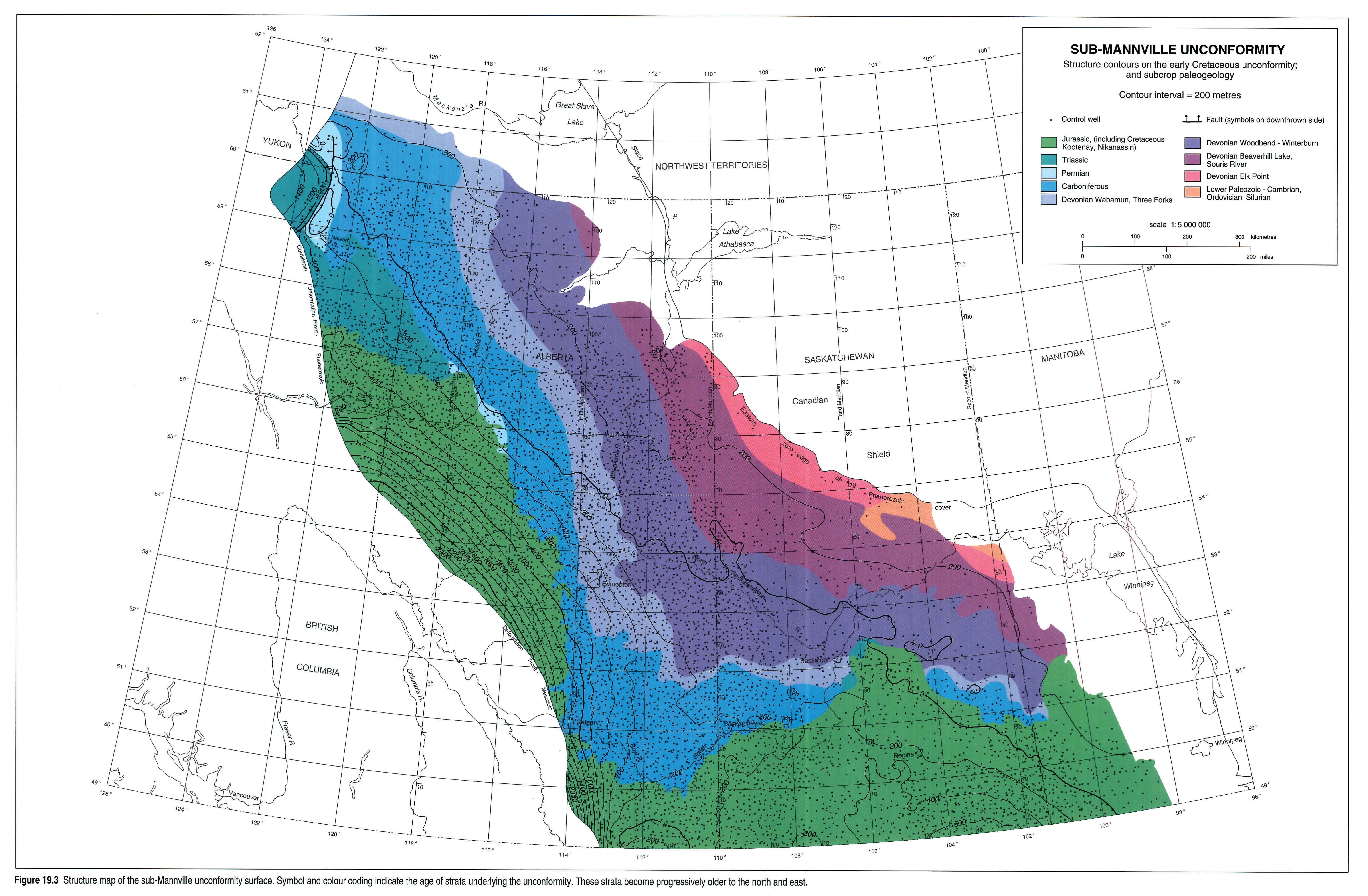
Bow Basin is a distinct structural entity and is a sub-basin of the Alberta Basin. Bow Basin's main characteristics are: its bow shape; northwest-southeast orientation; structure contours that swing to the west over its northern perimeter near the Alberta/British Columbia boundary (between 54° and 55° 30'N latitude, and 118° and 122°W longitude); separation by Calgary Platform, near 51°N latitude, into two sub-basins; and long geological history, in existence from the Early Cretaceous to the early Tertiary (Second White Specks marker to the Paskapoo Formation) (Burk, 1962; Taylor et al., 1964, Fig. 13-1; Williams and Burk, 1964, Fig. 12-15). The east-west orientation of structure contours in the north, beneath the general area of Grande Prairie, may be a result of Late Cretaceous reactivation of the Peace River Arch, or possibly vertical displacement along the Hay River Fault Zone to the north. Reactivation of the Peace River Arch into a positive element may have commenced as early as Early Cretaceous (see sub-Mannville unconformity structure contour map; Fig. 19.3, this volume).
Thickness
Formation thickness across the western subsurface of Alberta is illustrated in Figure 23.2. This isopach map illustrates the formation's thickness distribution in the subsurface along the western margin of Alberta from 49° to 55°N latitude. Isopachs are from resistivity logs (Figs. 23.5, 23.6) using the Cardium Zone Marker and the Russian Marker for the top and base of the formation respectively. The thickness of the formation in Bow Basin across and along strike is not uniform. However, in general, the isopachs indicate that the formation wedges toward the east, with a thickness greater than 165 m in the west and decreasing to a thickness less than 50 m in the east (Fig. 23.2). The formation's maximum and minimum thickness at its margins are unknown, because the formation has been eroded in the orogenic thrust belt to the west and lacks definition on wireline logs along its eastern boundary, where the sandy lithofacies merge eastward into mudstones undifferentiated from mudstones above and below the Cardium Formation interval (Fig. 23.6).
Across the map area from north to south, two thick lobate wedges are apparent, named here the Nordegg Lobe in the north and the Highwood Lobe in the south (Fig. 23.2). The two lobes are separated by a saddle highlighted by decreasing isolines north of Calgary, across Townships 30-40, slightly north of 52°N latitude and seemingly not coincident with Calgary Platform. These lobes reflect separate depocenters), the Nordegg Lobe localized to the Grande Prairie Low and the Highwood Lobe centered over the Pincher Creek Low and southern margins of the Grande Prairie Low.
North of Township 65, isolines also thin progressively northward and westward (Fig. 23.2). Similar isopach changes have been noted farther north (approximately 55°N latitude) by Burk (1962), and Hart and Plint (1990), using different Cardium Formation marker horizons. Hart and Plint (1990) have attributed these changes to vertical syntectonic movements of rejuvenated Peace River Arch normal faults and uplift parallel with the axis of the ancestral arch. An alternative is that the observed stratigraphic differences could be responses to thrusting associated with development of passive roof duplexes and triangle zones, which are common elsewhere in the basin in this stratigraphic interval and are associated with modern uplift of the Rocky Mountains (Teal, 1983; Skuce et al. 1992).
Subregional and Local Relations
Pembina Field and Vicinity - Upper Pembina River Member Reservoir
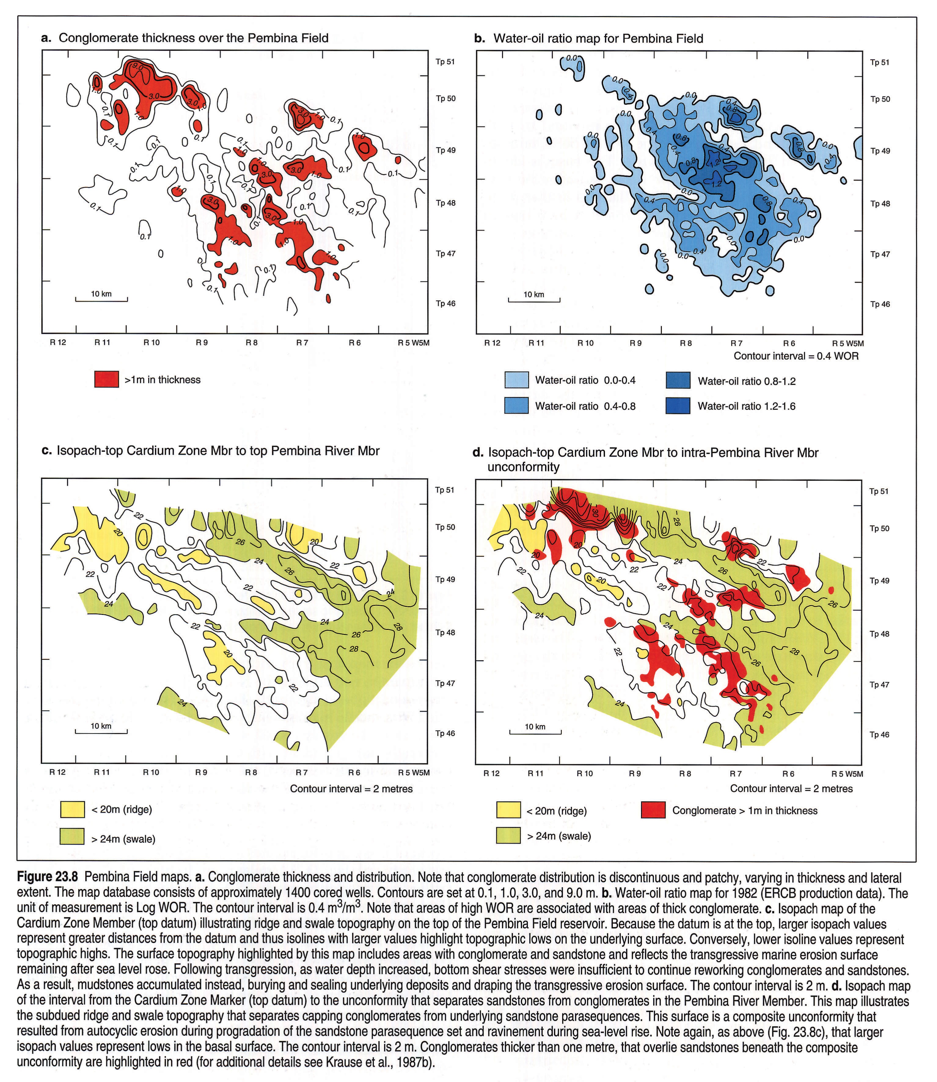
In the Pembina Field the Cardium Formation reservoir consists, in broad terms, of two stacked, terrigenous clastic reservoirs; a lower sandstone reservoir and an upper conglomerate reservoir, separated by a regional unconformity (Fig. 23.7; Krause et al., 1987b). Sandstones have high storage capacity (-h), but low to moderate flow capacity (kh), whereas conglomerates have low storage capacity (-h), but high flow capacity (kh) (Groeneveld, 1964; Gillund, 1969; Krause et al., 1987b). These conglomerates, as mapped over most of the Pembina Field, are arranged as discontinuous and patchy sheets ranging from less than 0.1 m to greater than 9.0 m in thickness (Fig. 23.8a; Krause et al., 1987b). It is significant that, locally, conglomerates present severe production problems as "thief zones" for secondary and enhanced recovery schemes, a response which is particularly evident where they form thick, pod-like accumulations (Fig. 23.8a, b; Gillund, 1969; Krause et al., 1987b, their Figs. 8 to 11).
The top of the Pembina reservoir, including the conglomerate, is characterized by a ridge and swale topography oriented northwest-southeast (Fig. 23.8c; Nielsen, 1957; Groeneveld, 1964; Krause, 1982; Krause et al., 1987b; Leggitt et al., 1990). The unconformity surface that separates the conglomerates from the underlying sandstones also displays a ridge and swale topography (Fig. 23.8d; Krause and Collins, 1984; Krause et al., 1987b). This surface is identified as the "E-5 erosion surface" by Leggitt et al. (1990) who mapped it using resistivity logs. There is continuing controversy over how conglomerates and sandstones can be distinguished on available resistivity logs (as discussed above) and thus over whether the capping conglomerates are included or excluded in their Figure 5 map (Leggitt et al., 1990, p. 1169). Nonetheless, using this map and core descriptions, they interpreted the origin of the "E-5" surface to be the result of southwest uplift and rotation of the basin floor, followed by subaerial exposure. Subsequently, the surface was modified by incision of underlying sandstones to produce a series of subparallel, shoreface steps during slow transgressions or stillstands, as the basin floor rotated backward and downward (Leggitt et al., 1990).
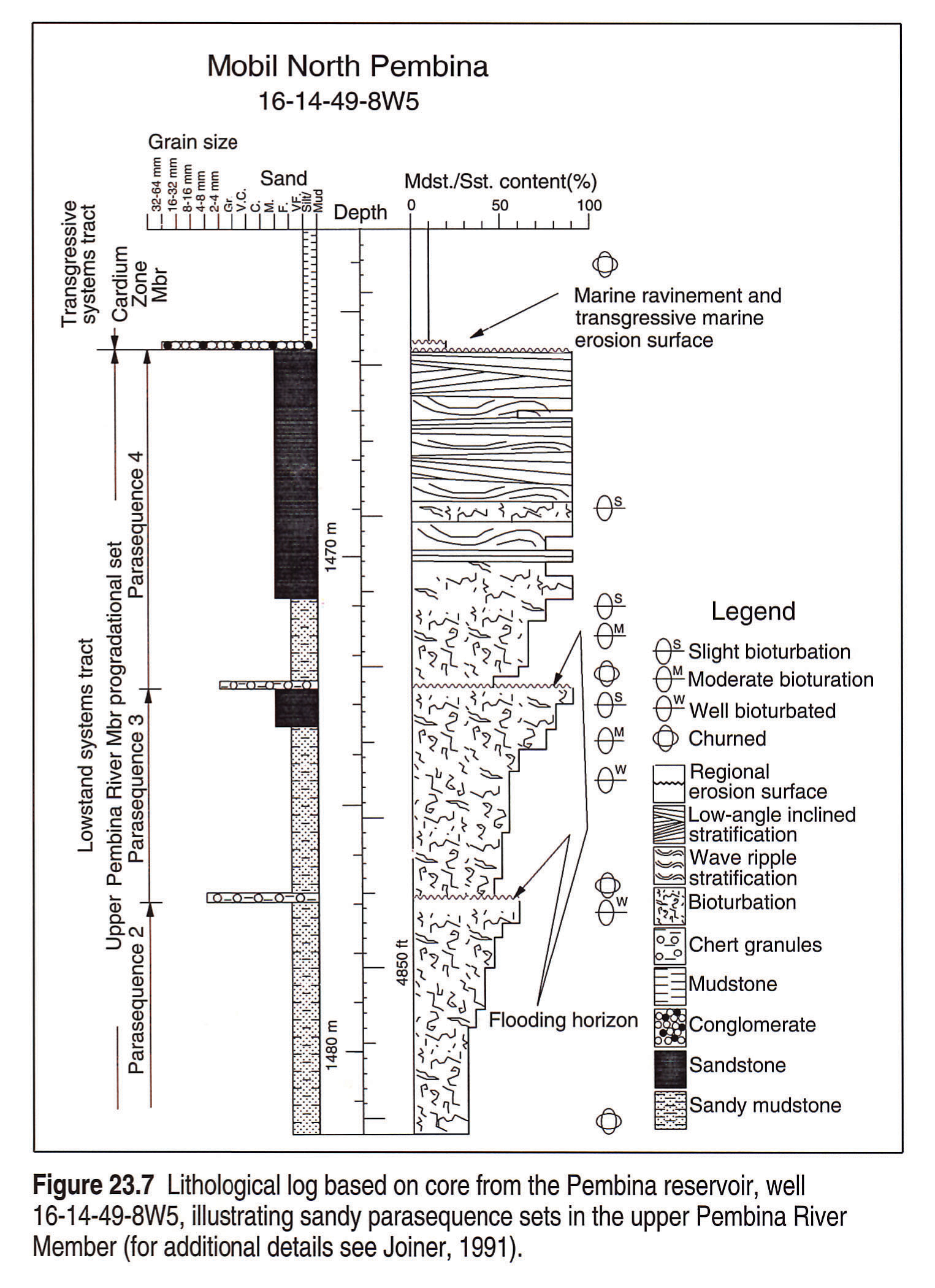
Sandstones underlying the erosion surface comprise a parasequence set composed of at least ten clinoforming, prograding and offlapping parasequences, bounded by disconformities (Joiner, 1991). Below the disconformities, parasequences consist of very fine-grained sandstones imprinted with current bedding, commonly low-angle inclined cross-stratification ("LIS" - Krause and Nelson, 1984). Above the disconformities, parasequences display bioturbated mudstones and very fine-grained sandstones, with medium to granule sized chert grains and griotte siderites (Figs. 23.7; 23.9; Joiner, 1991; Joiner and Krause, 1990, 1991). Disconformities could have formed by autocyclic shoreface erosion during periodic pauses in sedimentation, through temporary abandonment, sediment starvation, compactional subsidence and subsequent flooding and ravinement.
The unconformity separating the sandy parasequence sets from the overlying conglomerates is not a simple erosion surface, but consists instead of at least two disconformities (Joiner, 1991; Krause et al., in press): a lower disconformity present only locally and an upper one that is widespread throughout the Pembina Field. The lower, more local disconformity, is characterized by asymmetrical, parallel, northwest-southeast oriented, channel-like scours, up to 5 m deep, 3 km wide and 10-20 km long. These scours contain well sorted, crossbedded sandy conglomerates and poorly sorted, conglomeratic, muddy sandstones with marine trace fossils (Joiner, 1991; Krause et al., in press). The well sorted, crossbedded conglomerates are marine and appear to have been sculpted by tidal currents (Krause et al., in press). These deposits are incised and overlain by poorly sorted conglomerates that are associated with the upper disconformity. The lower erosion surface is truncated along the margins of the asymmetrical channel-like scours by the upper erosion surface. The aggregate of these surfaces is the unconformity separating sandstones from overlying conglomerates. The subdued ridge and swale topography of this surface is depicted in Figure 23.8d (Krause et al., 1987b; Joiner, 1991; Joiner and Krause, 1991).
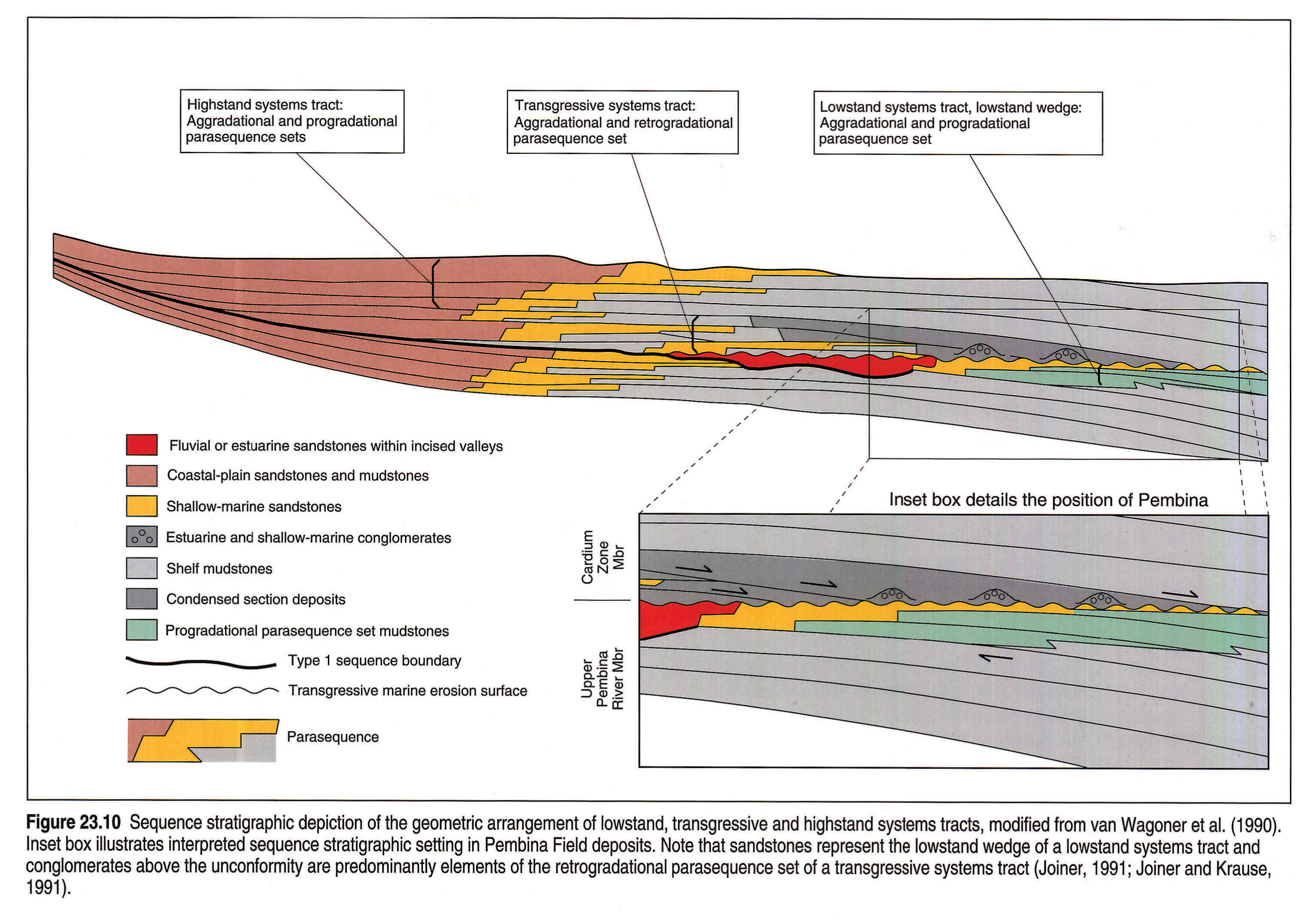
The lithological characteristics and the spatial relations of the various deposits and unconformities at Pembina and the immediate vicinity are analogous to ones observed in modern subaqueous deltas and marine-outer-central estuary settings (Joiner, 1991; Joiner and Krause, 1991). Sandstones prograded into the seaway during sea-level lowstand, as a result of general relative sea-level lowering, as first suggested by Keith (1985, 1991) for the Willesden Green Field to the southwest of Pembina. In contrast, most of the overlying pebble conglomerates were derived from estuarine storage areas to the west during ravinement and shoreline incision as relative sea level rose (Fig. 23.10; Joiner, 1991; Joiner and Krause, 1991). The unconformity separating sandstones from conglomerates, as indicated above, is complex. It formed initially in response to autocyclic reworking by tidal and wave erosion processes, as underlying sandstones prograded into the basin and, subsequently, by allocyclic shoreface incision through ravinement and storm wave processes as sea level rose (Joiner, 1991; Joiner and Krause, 1991; Krause et al., in press).
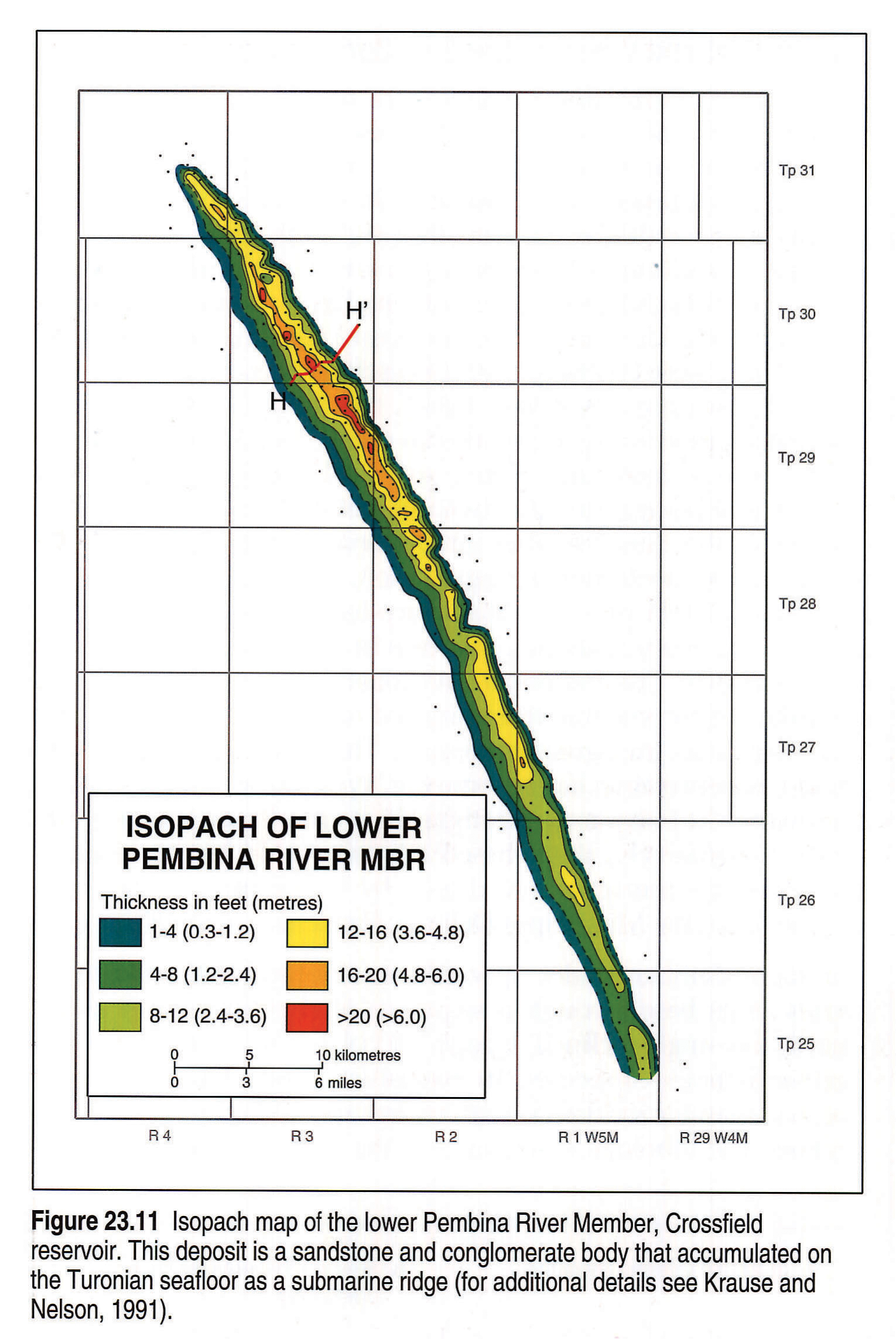
Crossfield Field and Vicinity - Lower PembinaRiver Member Reservoir
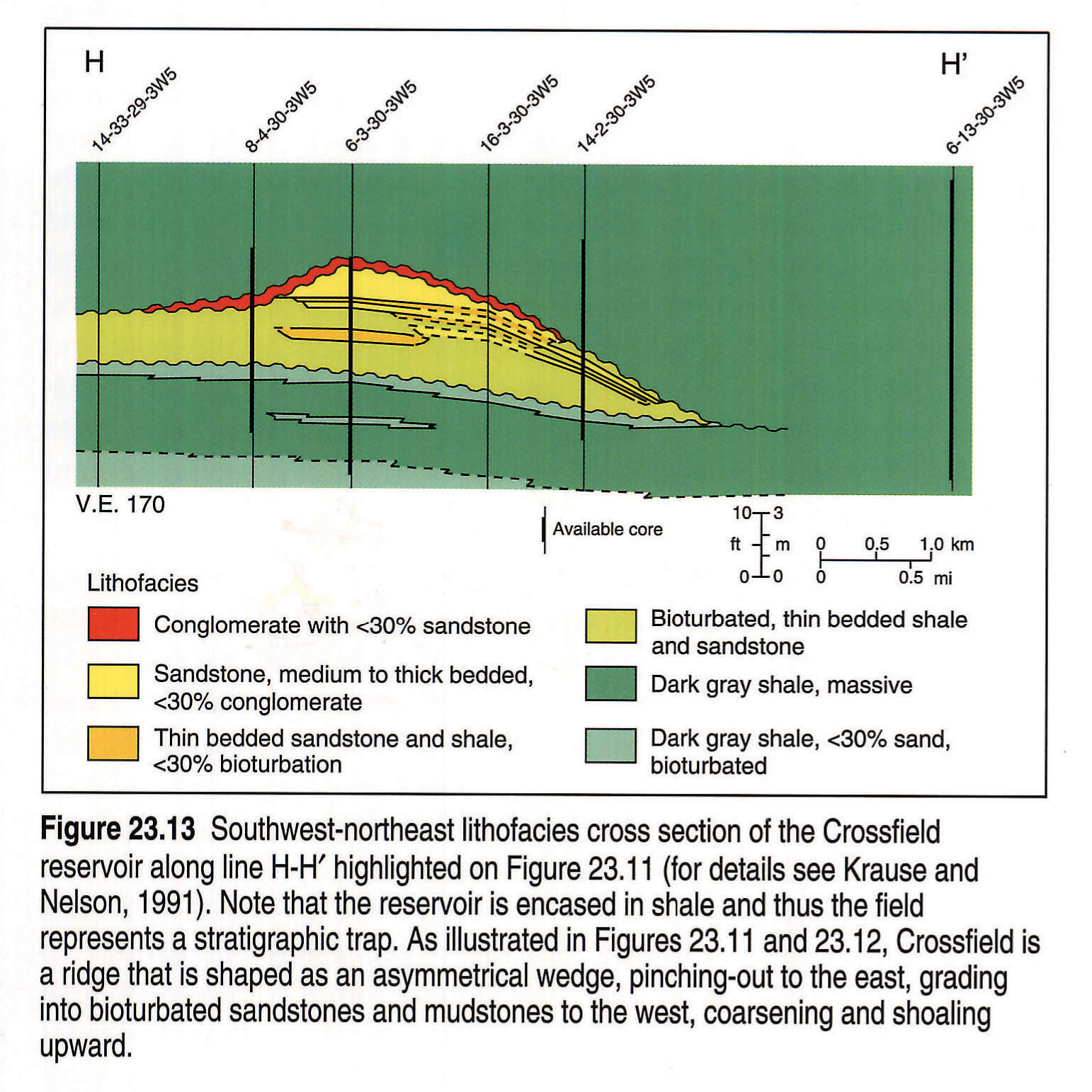
The Crossfield reservoir is a 72 km long, 2.5 to 5 km wide sandstone and conglomeratic sandstone ridge that accumulated on the Late Turonian seafloor (Figs. 23.11, 23.12; Berven, 1966; Pattison, 1987; Krause and Nelson, 1991, Pattison and Walker, 1992). The reservoir is areally restricted, encased in mudstones, complexly interlayered and characterized by five, marine, upward shoaling lithofacies that have been described and interpreted by Krause and Nelson (1991) (Fig. 23.13). The ridge may have been initiated during a relative sea-level lowstand, where inner shelf and lower shoreface, bioturbated and current bedded, mudstones and gritty mudstones were initially deposited on a scoured mudstone in a setting dominated by unidirectional current flow. Subsequently, the ridge shoaled to the point where combined wave and unidirectional current components influenced sedimentation, as indicated by beds with small- and medium-scale, low-angle inclined cross-stratification, plane-parallel laminae, and little or no bioturbation (Krause and Nelson, 1991). Alternatively, the ridge may be transgressive in origin, having accumulated on a topographic inhomogeneity that developed in response to bottom reworking and scour of mudstones as a result of rising relative sea level (see Krause and Nelson, 1991, their Fig. 17). Coarse material, gritty mudstones and sandstones, may have become progressively more abundant as sea level continued to rise and shoreline deposits to the west and northwest were incised by ravinement processes and transported offshore. Deposits eventually shoaled sufficiently to be reworked by fair-weather and storm-weather waves and tidal currents. Subsequently, the ridge was abandoned as rising relative sea level peaked and reworking of the ridge by storm-weather waves and currents resulted in a conglomeratic lag at the top. Finally, rising sea level placed the ridge beneath average storm wave-base and fine-grained sedimentation resumed, encasing the ridge in mudstones. In addition, the sediment flux of the basin may have been such that fine-grained sediment input and transport overwhelmed coarser grained sediments (see below).
As discussed by Krause and Nelson (1991, their Fig. 17), the ridge developed on a topographic inhomogeneity and over time grew upward, eastward and southward. This pattern of growth indicates that dominant current directions on the Late Turonian seafloor were ridge-parallel with across ridge components, directed from the northwest to the southeast (Figs. 23.11, 23.12; Krause and Nelson, 1991). Processes such as these have been reported for the Atlantic inner, storm-dominated shelf of the United States by Swift and Field (1981). As suggested by Swift and Niedoroda (1985), tidal sediment transport processes are similar to storm transport processes and would have similar responses. The sediment transport processes could also intensify if storm and tidal currents are combined (Swift and Niedoroda, 1985). Combined storm and tidal processes may have fashioned the Crossfield reservoir into a ridge. Observed lithofacies clearly point to modification by storm flows and the dimensions of the ridge are similar to dimensions observed in modern tidal settings (as was originally pointed out by Off, 1963). Moreover, thick, black, massive, laminated and bioturbated mudstones, which enclose the ridge, reflect an overabundance of muds and silts at the time of deposition. These mudstone sequences may have formed in response to nearshore mud transport and depositional systems, as observed today along the shelves and coasts of Suriname, south Louisiana, the East China and Yellow seas, and Malabar (Wells and Coleman, 1981; Rine and Ginsburg, 1985; Wright et al., 1988; Krause and Nelson, 1991).
Kakwa Field and Vicinity - Cardium Zone Member Reservoir
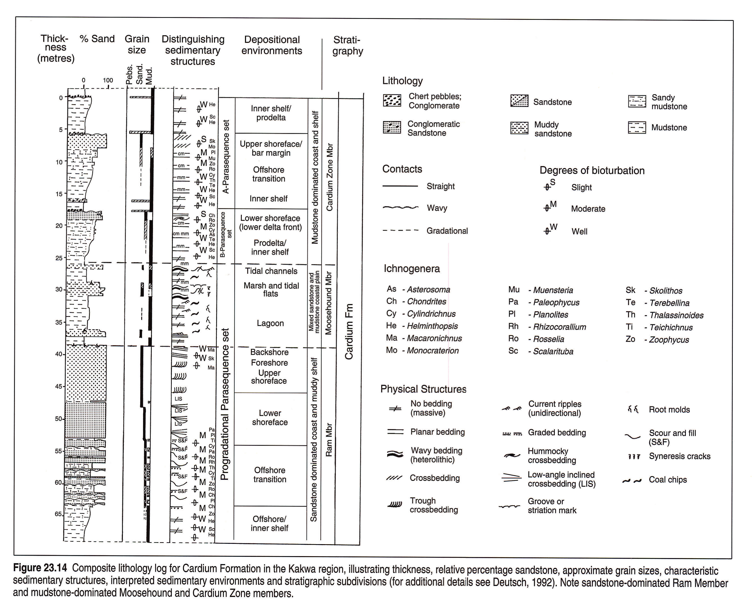
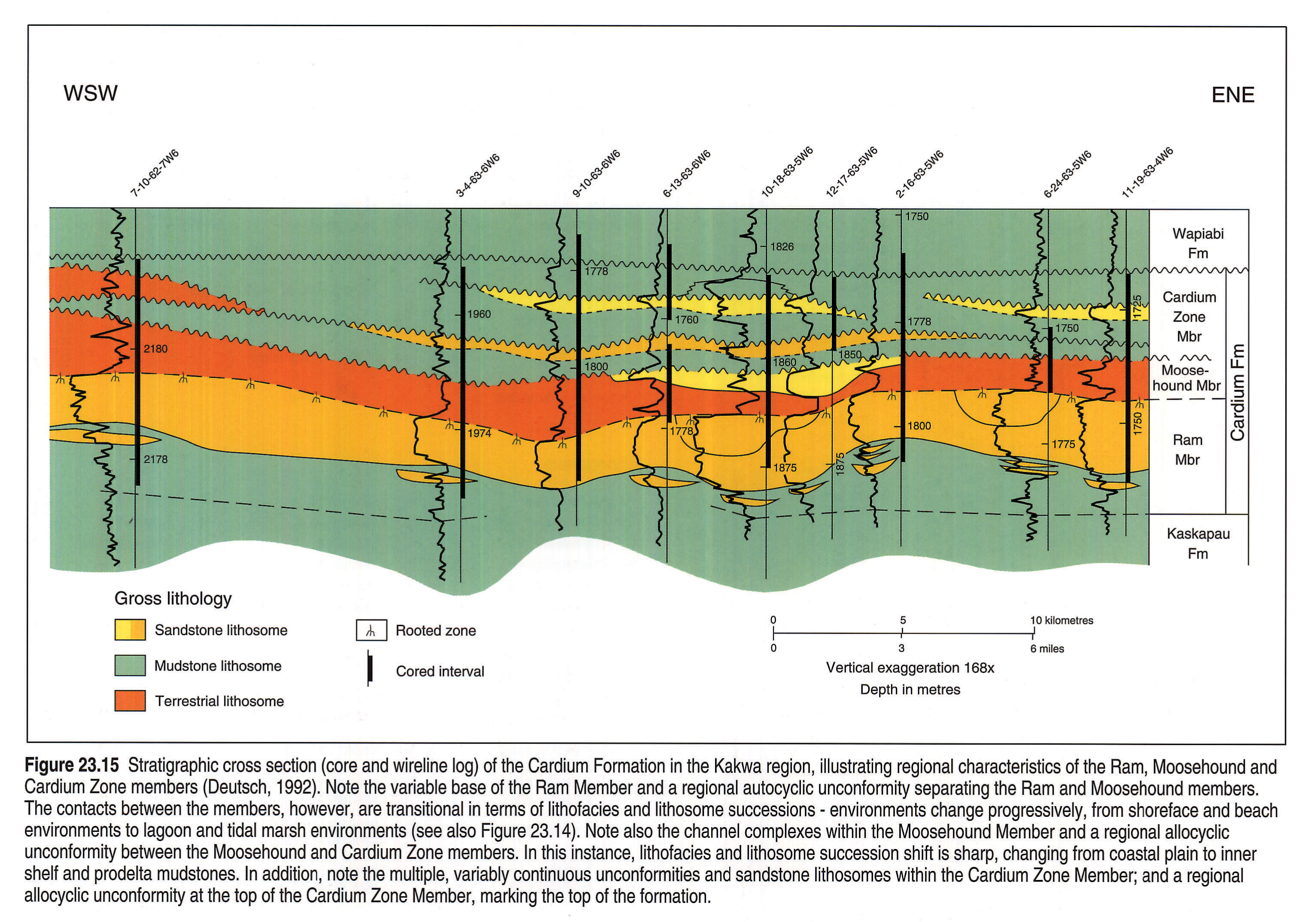
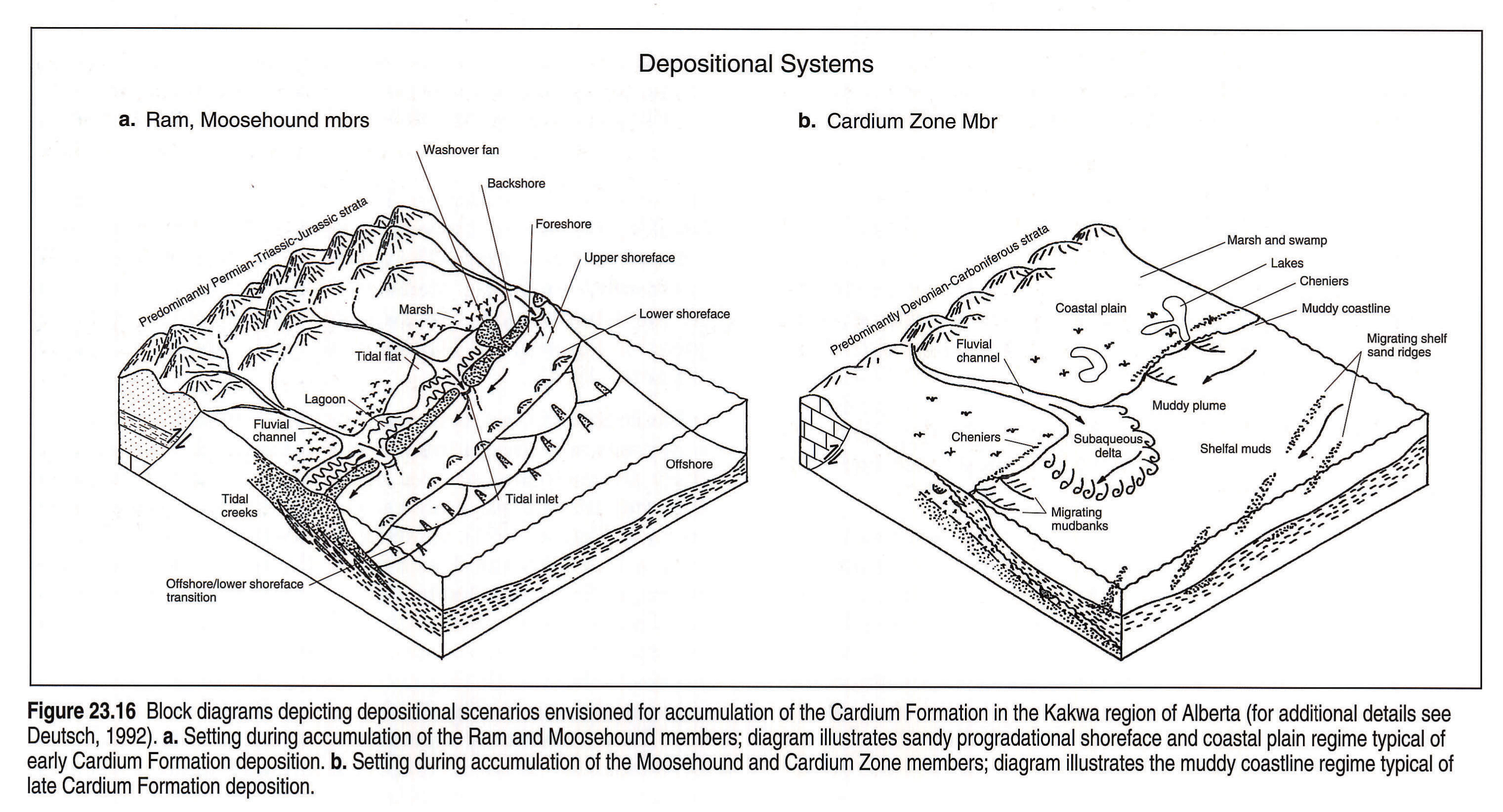
The Cardium Formation in the Kakwa region is subdivided into three formal units, from base to top, the Ram, Moosehound and Cardium Zone members (Fig. 23.14; Deutsch, 1992). The basal, sandstone-dominated Ram Member is relatively uniform, with northwest- to southeast-trending thin and thick zones. The middle unit, the Moosehound Member, is an eastward thinning terrestrial mudstone and sandstone that is onlapped in the Kakwa area by the Cardium Zone Member and farther west intertongues with it (Fig. 23.15; Plint, 1988; Deutsch, 1992; Deutsch and Krause, 1990, 1991). In the Kakwa area (Nordegg Lobe), the Ram and Moosehound members represent a progradational parasequence that advanced in response to lowering relative sea level (Deutsch, 1992). Plint (1988) has also suggested that two types of shoreface sequences are present in the Ram Member: gradational and sharp based. The former can be attributed to progradation, as above. However, Plint (1988) has further proposed that sharp based shoreface sequences are not only progradational, but form in response to rapid lowering of sea level. The end result envisioned by Plint (1988) for these deposits is their potential stranding and isolation on the shelf as sea level rises and transgression occurs. This attractive, but unconfirmed, interpretation has become the "type study" for the "forced regressions" of sequence stratigraphers (see Posamentier et al., 1992). Alternatively, sharp-based deposits could be the result of reworking by transgression, driven by subsidence, as has been described for the Mississippi Delta by Penland et al. (1988).
The Ram Member grades upward from bioturbated sandy mudstones at its base through a sequence of rhythmites and gutter casted, low-angle inclined, trough and planar tabular cross-stratified sandstones, capped by an extensively bioturbated, crossbedded and massive sandstone with rooted and pedogenically altered profiles. The lithological sequence of the Ram Member represents depositional environments that change progressively upward from inner shelf and offshore transition to lower-, middle-, and upper-shoreface, foreshore and backshore environments (Figs. 23.15, 23.16; Plint, 1988; Deutsch, 1992; Deutsch and Krause, 1990, 1991). In contrast, the Moosehound Member consists of extensive deposits of carbonaceous and pelecypod-rich mudstones, interbedded and commonly pedogenically altered mudstone and sandstone, and wave and unidirectional current-bedded sandstones (Plint and Walker, 1987; Deutsch, 1992; Deutsch and Krause, 1991, 1992; Krause et al., 1992). The lithofacies architecture of these two members can be interpreted as representing a prograding, mesotidal barrier and backbarrier system that was influenced by fair-weather and storm-weather wave, tidal and riverine processes (Fig. 23.16a; Deutsch, 1992; Deutsch and Krause, 1990). Alternatively, Plint and Walker (1987) have interpreted the Ram and Moosehound members as being characteristic of a regressive and progradational, microtidal, barrier-lagoon system maintained by close interplay between subsidence and sedimentation.
The overlying Cardium Zone Member accumulated in a shallow shelf setting characterized by several parasequences, bound by disconformities. These contacts place bioturbated mudstones over current-bedded sandstones and represent deepening events. Toward the top of the Cardium Zone Member, parasequences become sandier and these deposits form areally restricted, long, linear, northwest-southeast-oriented ridges. To the west, Cardium Zone Member deposits interfinger with mudstones of the Moosehound Member (Figure 23.16b; Deutsch, 1992; Deutsch and Krause, 1991). The sedimentary and stratigraphic relations observed suggest that these rocks accumulated in mud-dominated settings, such as are observed in modern environments of Suriname, south Louisiana, the East China and Yellow seas, and the Malabar coast (Wells and Coleman, 1981; Rine and Ginsburg, 1985; Wright et al., 1988; Deutsch, 1992; Deutsch and Krause, 1991; Krause et al. 1992).
The Kakwa area is particularly important in understanding the depositional history of the formation, because these rocks preserve two very different, but juxtaposed, sedimentation styles - the nearshore to coastal plain sandstone-dominated Ram/Moosehound members and the nearshore to coastal plain mudstone-dominated Cardium Zone/Moosehound members. This juxtaposition of lithologies and similar depositional environments appears to be the product of differences in available erodable materials from the orogenic wedge of the Mesozoic Rocky Mountain Foreland Basin, rather than juxtaposition due to oscillations of relative sea level and erosion of sandstones during sea-level rises and concomitant ravinement (Fig. 23.16; Heise, 1987; Plint et al., 1987; Plint, 1988; Deutsch, 1992; Krause et al., 1992). Heise (1987), in a palynological study of the formation in outcrop and subsurface elsewhere in the basin, has shown that Upper Cretaceous palynomorphs succeed each other in normal stratigraphic order, but reworked palynomorphs of Triassic, Permian, Carboniferous and Devonian ages are inverted stratigraphically. Abundant Paleozoic palynomorphs are found in higher intervals of the formation and lower Mesozoic palynomorphs are found in lower intervals. The relations observed by Heise (1987) indicate that Paleozoic carbonate rocks contributed progressively more sediment to the foreland basin during Cardium Formation sedimentation as the orogenic foreland wedge continued to be uplifted, unroofing older rocks, and the locus of foreland basin subsidence migrated toward the foreland. Thus, ample supply of fine-grained sediment and diminishing terrigenous coarse clastic supply would have contributed to increasing accumulation of mudstone deposits later in the history of the formation.
Economic Geology
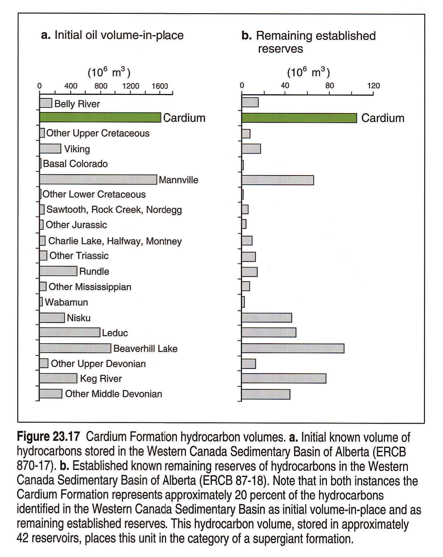
The volume of light hydrocarbons stored in the Cardium Formation is enormous (Fig. 23.17). Established reserves are greater than 1.6 x 10⁶ m3 of oil (>10 x 109 BOIP; ERCB 87-18). Cardium Formation light hydrocarbon reserves also dominate foreland basin oil reserves. The known initial in-place oil volume contained in the Cardium Formation is almost one quarter of the total oil volume of the Western Canada Sedimentary Basin and this oil is predominantly light (ERCB 87-18). The initial oil in-place is represented by at least 42 fields producing from the Ram, Moosehound, lower and upper Pembina River and Cardium Zone members (23.17a). Presently remaining reserves, accessible with currently available technology, amount to 20 percent of the remaining reserves of the Western Canada Sedimentary Basin (Fig. 23.17b; ERCB 87-18). Oil recovery from the formation is low and on average amounts to approximately 20 percent (McLeod, 1978; Purvis and Bober, 1979; Krause et al., 1987b). The low oil recovery factor makes this formation Canada's single largest conventional petroleum reserve. Thus, the Cardium Formation is deserving of continued study by the geological and engineering community.
Acknowledgements
Throughout this project many people contributed generously in many ways. In particular, we thank Jim Dixon, Don Keith, John Kramers, P.J. Lee, Mika Madunicky, Andrew MacRae, Robert McMechan, Grant Mossop, Ken Nairn, Alice Payne and Irina Shetsen. We thank Dave Smith and Canadian Hunter Exploration Ltd. who contributed Figure 23.4. In addition, we thank Atlas reviewers Dave Smith, Lee Krystinik and Tom Moslow for helpful reviews and discussions that refined concepts presented in the text. Work on the Cardium Formation was made possible by funding provided by a number of organizations, which we all thank. They include: Alberta Oil Sands Technology and Research Authority, Canadian Hunter Exploration Ltd., Canadian Occidental Petroleum Ltd., Canterra Energy Ltd., Mobil Oil Canada, Natural Science and Engineering Research Council, Norcen Energy Resources Ltd., Petroleum Recovery Institute, Texaco Canada Resources, and The University of Calgary.
References
- Alpay, O.A. 1972. A practical approach to defining reservoir heterogeneity. Journal of Petroleum Technology, v. 24, p. 841-848.
- Bally, A.W., Gordy, P.L., and Stewart, G.A. 1966. Structure, seismic data and orogenic evolution of the southern Canadian Rocky Mountains. Bulletin of Canadian Petroleum Geology, v. 14, p. 337-381.
- Barton, C.C. 1983. Systematic jointing in the Cardium sandstone along the Bow River, Alberta, Canada. Ph.D. Thesis, Yale University, New Haven, Connecticut, U.S.A., 301 p.
- Bell, J.S. and Gough, D.I. 1981. Intraplate stress orientations from Alberta oil-wells. Evolution of the Earth, Geodynamic Series, v. 5, p. 96-104.
- Bergman, K.M. and Walker, R.G. 1987. The importance of sea-level fluctuations in the formation of linear conglomerate bodies; Carrot Creek Member of Cardium Formation, Cretaceous Western Interior Seaway, Alberta, Canada. Journal of Sedimentary Petrology, v. 57, p. 651-665.
- Berven, R.J. 1966. Cardium sandstone bodies, Crossfield-Garrington area, Alberta. Bulletin of Canadian Petroleum Geology, v. 14, p. 208-240.
- Burk Jr., C.F. 1962. Structure, isopach, and facies maps of Upper Cretaceous marine succession, west-central Alberta and adjacent British Columbia. Geological Survey of Canada, Paper 62-31, 10 p.
- Chakravorty, S.K., Brown, P.R., and Endsin, N. 1978. A review of waterflood performance in Garrington Cardium A and B pools, Unit No. 2. Journal of Petroleum Technology, v. 30, p. 869-874.
- Chappell, J.F. 1989. The Carrot Creek "S" pool. Chapter 9. Upper Cretaceous reservoirs. In: Geophysical Atlas of Western Canadian Hydrocarbon Pools. L.V. Hills and D.A. Cederwall (eds.). Calgary, Canadian Society of Exploration Geophysicists and Canadian Society of Petroleum Geologists, p. 283-289.
- Creaney, S. and Allan, J. 1992. Petroleum systems in the foreland basin of Western Canada. In: Foreland Basins. R.G. Macqueen and D.A. Leckie (eds.). American Association of Petroleum Geologists, Memoir 55, p. 279-308.
- Deroo, G., Powell, T.G., Tissot, B., and McCrossan, R.G. 1977. The origin and migration of petroleum in the Western Canada Sedimentary Basin, Alberta. Geological Survey of Canada, Bulletin 262, 136 p.
- Deutsch, K.B. 1992. Sedimentology and stratigraphy of the Cretaceous Cardium Formation, Kakwa region, west-central Alberta. M.Sc. Thesis, The University of Calgary, Calgary, Alberta, 300 p.
- Deutsch, K.B. and Krause, F.F. 1990. A marine to terrestrial succession in the Cardium Formation, Kakwa region, west-central Alberta: Implications for relative sea-level movements. Bulletin of Canadian Petroleum Geology, Technical Program Abstracts, v. 38, p. 161.
- Deutsch, K.B. and Krause, F.F. 1991. A comparison between sand- and mud-dominated shelf to shoreline sequences deposited in the Cretaceous Western Interior Seaway: Examples from the Cardium Formation, Kakwa region, west-central Alberta. Bulletin of Canadian Petroleum Geology, Technical Program Abstracts, v. 39, p. 210.
- Duke, W.L. 1985. Sedimentology of the Upper Cretaceous Cardium Formation in southern Alberta, Canada. Ph.D. Thesis, McMaster University, Hamilton, Ontario, 724 p.
- Gillund, G.N. 1969. Review of the Lobstick Cardium miscible flood. Journal of Canadian Petroleum Technology, v. 8, p. 66-74.
- Griffith, L.A. 1981. Depositional environment and conglomerate diagenesis of the Cardium Formation, Ferrier Field, Alberta. M.Sc. Thesis, The University of Calgary, Calgary, Alberta, 132 p.
- Groeneveld, H. 1964. Pressure maintenance by fluid injection in the north Pembina Cardium Unit No. 1. Journal of Petroleum Technology, v. 16, p. 977-982.
- Hall, R.L., Krause, F.F., Joiner, S.D., and Deutsch, K.B. 1991. Biostratigraphy and allostratigraphy in the Cardium Formation, Upper Cretaceous, Alberta. Program with Abstracts, Geological Association of Canada, p. A49.
- Hall, R.L., Krause, F.F., Joiner, S.D., and Deutsch, K.B. 1992. Biostratigraphic evaluation of a "sequence boundary": Cardinal/Leyland unconformity (Cardium Formation) at Seebe, and subsurface equivalents at Pembina, Alberta. Mesozoic of the Western Interior, Society of Economic Paleontologists and Mineralogists Meeting, Ft. Collins, Colorado, Abstracts, p. 28.
- Hall, R.L., Krause, F.F., Joiner, S.D., and Deutsch, K.B. (in press). Biostratigraphic evaluation of a "sequence boundary": The Cardinal/Leyland unconformity (Cardium Formation) at Seebe and subsurface equivalents at Pembina, Alberta. Bulletin of Canadian Petroleum Geology.
- Hart, B.S. and Plint, A.G. 1989. Gravelly shoreface deposits: a comparison of modern and ancient facies sequences. Sedimentology, v. 36, p. 551-557.
- Hart, B.S. and Plint, A.G. 1990. Upper Cretaceous warping and fault movement on the southern flank of the Peace River Arch, Alberta. Bulletin of Canadian Petroleum Geology, v. 38A, p. 190-195.
- Hayes, B.J.R. and Smith, D.G. 1987. Discussion on Cardium - Formation 6. Stratigraphic framework of the Cardium in subsurface. Bulletin of Canadian Petroleum Geology, v. 35, p. 363-365.
- Heise, R.H. 1987. Palynology of the Cardium Formation, west-central Alberta. M.Sc. Thesis, The University of Calgary, Calgary, Alberta, 101 p.
- Irish, E.J.W. 1965. Geology of the Rocky Mountain Foothills, - Alberta (between latitudes 53°15' and 54°15'). Geological Survey of Canada, Memoir 334, 241 p.
- Joiner, S.D., 1991. Stratigraphic architecture of a parasequence set and the genetic implications for the Cardium Fm. at Pembina. M.Sc. Thesis, The University of Calgary, Calgary, Canada, 384 p.
- Joiner, S.D. and Krause, F.F. 1990. Cardium Formation stratigraphy in the Pembina Field and surrounding area. Bulletin of Canadian Petroleum Geology, v. 38, p. 168.
- Joiner, S.D. and Krause, F.F. 1991. Stratigraphic architecture of the Cardium Formation in the Pembina Field, west-central Alberta. Bulletin of Canadian Petroleum Geology, Abstracts, v. 39, p. 215.
- Keith, D.A.W. 1985. Sedimentology of the Cardium Formation (Upper Cretaceous), Willesden Green Field, Alberta. M.Sc. Thesis, McMaster University, Hamilton, Canada, 241 pp.
- Keith, D.A.W. 1991. Sedimentology and geometry of the Cardium (Turonian) sandstone and conglomerate at Willesden Green Field, Alberta: Offshore sand body or incised prograding strand plain deposit? In: Shelf Sand and Sandstone Bodies: Geometry, Facies and Sequence Stratigraphy. D.J.P. Swift, G.F. Oertel, R.W. Tillman, and J.A. Thorne (eds.). International Association of Sedimentologists, Special Publication 14, p. 457-486.
- Krause, F.F. 1982. Geology of the Pembina Cardium Pool. In: Depositional Environments and Reservoir Facies in Some Western Canadian Oil and Gas Fields. J.C. Hopkins (ed.). University of Calgary Core Conference, Department of Geology and Geophysics, p. 15-27.
- Krause, F.F. 1990. Lithofacies distribution and continuity of Cardium Formation (Upper Cretaceous) tempestites, Alberta Foothills, Canada. Association Round Table, American Association of Petroleum Geologists, v. 74, p. 374-375.
- Krause, F.F. and Collins, H.N. 1984. Pembina recovery efficiency study: A geological and engineering synthesis. Petroleum Recovery Institute, v. I and II (Appendices), 300 p.
- Krause, F.F., Collins, H.N., French, P.R., and Warner, J.D. 1987a. Bibliography of geological and engineering studies of the Cardium Formation and its hydrocarbon reservoirs. Petroleum Recovery Institute, Report 1987-3, 61 p.
- Krause, F.F., Collins, H.N., Nelson, D.A., Machemer, S.D., and French, P.R. 1987b. Multiscale anatomy of a reservoir: Geological characterization of Pembina-Cardium pool, west- central Alberta, Canada. American Association of Petroleum Geologists Bulletin, v. 71, p. 1233-1260.
- Krause, F.F., Deutsch, K.B., Hopkins, J.C., Heise, R., and Hills, L.V. 1992. Tectonic origin for mudstone vs. sandstone dominated marine shelf to shoreline sequences: Cardium Formation (Upper Cretaceous, Turonian-Coniacian), Kakwa region, west-central Alberta. Abstracts, Society of Economic Paleontologists and Mineralogists Theme Meeting, Mesozoic of the Western Interior, Ft. Collins, Colorado, Abstracts p. 38.
- Krause, F.F., Hills, L.V., Joiner, S.D., and Nunez-Betelu, L.M. (in press). Conglomeratic tidalites: Conglomerate and sandstone beds with mudstone couplets, Cardium Formation, Pembina and Carrot Creek fields, Alberta, Canada. Bulletin of Canadian Petroleum Geology.
- Krause, F.F. and Nelson, D.A. 1984. Storm event sedimentation: Lithofacies association in the Cardium Formation, Pembina area, west-central Alberta, Canada. In: The Mesozoic of Middle North America. D.F. Stott and D.J. Glass (eds.). Canadian Society of Petroleum Geologists, Memoir 9, p. 485-511.
- Krause, F.F. and Nelson, D.A. 1991. Evolution of an Upper Cretaceous (Turonian) shelf sandstone ridge: Analysis of the Crossfield - Cardium pool, Alberta, Canada. In: Shelf Sand and Sandstone Bodies: Geometry, Facies and Sequence Stratigraphy. D.J.P. Swift, G.F. Oertel, R.W. Tillman, and J.A. Thorne, (eds.). International Association of Sedimentologists, Special Publication 14, p. 427-456.
- Leggitt, S.M., Walker, R.G., and Eyles, C.H. 1990. Control of reservoir geometry and stratigraphic trapping by erosion surface E5 in the Pembina-Carrot Creek area, Upper Cretaceous Cardium Formation, Alberta, Canada. American Association of Petroleum Geologists, Bulletin, v. 74, p. 1165-1182.
- Leggitt, S.M., French, P.R., and Shaw, J.C. 1992. Reference database for the Cardium Formation in Western Canada. Petroleum Recovery Institute, Report 1992-10, 140 p.
- Machemer, S.D. 1984. Lithofacies and diagenesis of the Cardium Formation, northeast Pembina area, Alberta. M.Sc. Thesis, The University of Calgary, Calgary, Alberta, 160 p.
- Machemer, S.D. and Hutcheon, I. 1988. Geochemistry of early carbonate cements in the Cardium Formation, central Alberta. Journal of Sedimentary Petrology, v. 58, p. 136-147.
- MacKay, P.A. 1991. A geometric, kinematic and dynamic analysis of the structural geology at Turner Valley, Alberta. Ph.D. Thesis, The University of Calgary, Calgary, Alberta, 138 p.
- Martin, R. 1956. The Jumpingpound Gas Field. Guide Book, Sixth Annual Field Conference, Bow Valley. Alberta Society of Petroleum Geologists, 162 p.
- McLeod, J.G.F. 1978. Successful injection pattern alternation, Pembina J. Lease, Alberta. Journal of Canadian Petroleum Technology, v. 17, p. 51-55.
- Michaelis, E.R. 1957. Cardium sedimentation in the Pembina River area. Journal of the Alberta Society of Petroleum Geologists, v. 5, p. 73-77.
- Michaelis, E.R. and Dixon, G. 1969. Interpretation of depositional processes from sedimentary structures in the Cardium sand. Bulletin of Canadian Petroleum Geology, v. 17, p. 410-443.
- Moore, P.F. 1989. The Kaskaskia Sequence: Reefs, platforms and foredeeps. The Lower Kaskaskia Sequence - Devonian. In: Western Canada Sedimentary Basin. A Case History. B.D. Ricketts (ed.). Canadian Society of Petroleum Geologists, Chpt. 9, p. 139-164.
- Muecke, G.K. and Charlesworth, H.A.K. 1966. Jointing in folded Cardium sandstones along the Bow River, Alberta, Canada. Canadian Journal of Earth Sciences, v. 3, p. 579-596.
- Nazar, B. 1992. An interpretive study of multicomponent seismic data from the Carrot Creek area of west-central Alberta. M.Sc. Thesis, The University of Calgary, Calgary, Alberta, 106 p.
- Nielsen, A.R. 1957. Cardium stratigraphy of the Pembina Field. Journal of the Alberta Society of Petroleum Geologists, v. 5, p. 64-72.
- Nielsen, A.R. and Porter, J.W. 1984. Pembina oilfield, in retrospect. In: The Mesozoic of middle North America, D.F. Stott and D.J. Glass (eds.). Canadian Society of Petroleum Geologists, Memoir 9, p. 1-13.
- Off, T. 1963. Rhythmic linear sand bodies caused by tidal currents. American Association of Petroleum Geologists Bulletin, v. 47, p. 324-341.
- Ollerenshaw, N.C. 1966. Burnt Timber Creek. Geological Survey of Canada, Map 11-1965, Scale 1:63 360. Marginal notes.
- Ollerenshaw, N.C. 1968a. Limestone Mountain. Geological Survey of Canada, Map 8-1968, Scale 1:50 000.
- Ollerenshaw, N.C. 1968b. Panther Culmination. Geological Survey of Canada, Map 24-1967, Scale 1:63 360. Marginal notes.
- Ollerenshaw, N.C. 1970. Marble Mountain. Geological Survey of Canada, Map 7-1969, Scale 1:50 000. Marginal notes.
- Ollerenshaw, N.C. 1972a. Wildcat Hills (West Half). Geological Survey of Canada, Map 1351A, Scale 1:50 000.
- Ollerenshaw, N.C. 1972b. Lake Minnewanka (East Half). Geological Survey of Canada, Map 1347A, Scale 1:50 000.
- Ollerenshaw, N.C. 1974. Fallentimber Creek (West Half). Geological Survey of Canada, Map 1387A, Scale 1:50 000.
- Ollerenshaw, N.C. 1976a. Jumpingpound Creek (East Half). Geological Survey of Canada, Map 1419A, Scale 1:50 000.
- Ollerenshaw, N.C. 1976b. Jumpingpound Creek (West Half). Geological Survey of Canada, Map 1420A, Scale 1:50 000.
- Ollerenshaw, N.C. 1978. Calgary. Geological Survey of Canada, Map 1457A, Scale 1:250 000.
- Parsons, H.E. 1955. Pembina - local geology. Canadian Oil and Gas Industries, v. 8, p. 57-63.
- Parsons, H.E. and Nielsen, A.R. 1954. The Pembina Oil Field. Western Miner and Oil Review, v. 27, p. 76-81.
- Pattison, S.A.J. 1987. Transgressive, incised shoreface deposits of the Burnstick Member (Cardium "B" sandstone) at Caroline, Crossfield, Garrington and Lochend; Cretaceous Western Interior Seaway, Alberta, Canada. In: Sequences, Stratigraphy, Sedimentology: Surface and Subsurface. D.P. James and D.A. Leckie (eds.). Canadian Society of Petroleum Geologists, Memoir 15, p. 155-166.
- Pattison, S.A.J. and Walker, R.G. 1992. Deposition and interpretation of long, narrow sandbodies underlain by a basinwide erosion surface: Cardium Formation, Cretaceous Western Interior Seaway, Alberta, Canada. Journal of Sedimentary Petrology, v. 62, p. 292-309.
- Penland, S., Boyd, R., and Suter, J.R. 1988. Transgressive depositional systems of the Mississippi delta plain: A model for barrier shoreline and shelf sand development. Journal of Sedimentary Petrology, v. 58, p. 932-949.
- Pemberton, S.G. and Frey, R.W. 1984. Ichnology of storm-influenced shallow marine sequence: Cardium Formation (Upper Cretaceous) at Seebe, Alberta. In: The Mesozoic of Middle North America. D.F. Stott and D.J. Glass (eds.). Canadian Society of Petroleum Geologists, Memoir 9, p. 281-304.
- Plint, A.G. 1988. Sharp-based shoreface sequences and "offshore bars" in the Cardium Formation of Alberta: Their relationship to relative changes in sea level. In: Sea-level Changes: An Integrated Approach. C.K. Wilgus, G. St. C. Kendall, H.W. Posamentier, C.A. Ross, and J.C. Van Wagoner, (eds.). Society of Economic Paleontologists and Mineralogists, Special Publication 42, p. 357-370.
- Plint, A.G., Walker, R.G., and Bergman, K.M. 1986. Cardium Formation 6. Stratigraphic framework of the Cardium in subsurface. Bulletin of Canadian Petroleum Geology, v. 34, p. 213-225.
- Plint, A.G. and Walker, R.G. 1987. Cardium Formation 8: Facies and environments of the Cardium shoreline and coastal plain in the Kakwa Field and adjacent areas, northwestern Alberta. Bulletin of Canadian Petroleum Geology, v. 35, p. 48-64.
- Plint, A.G., Walker, R.G., and Bergman, K.M. 1987. Cardium Formation 6. Stratigraphic framework of the Cardium in subsurface. Reply to discussions Rine, J.M., Helmhold, K.P. and Bartlett, G.A.; and Hayes, B.J.R. and Smith, D.G. Bulletin of Canadian Petroleum Geology, v. 35, p. 365-374.
- Plint, A.G., Walker, R.G., and Duke, W.L. 1988. An outcrop to subsurface correlation of the Cardium Formation in Alberta. In: Sequences, Stratigraphy, Sedimentology: Surface and Subsurface. D.P. James and D.A. Leckie (eds.). Canadian Society of Petroleum Geologists, Memoir 15, p. 167-184.
- Posamentier, H.W., Allen, G.P., and James, D.P. 1992. Forced regressions in a sequence stratigraphic framework: Concepts, examples, and exploration significance. American Association of Petroleum Geologists Bulletin, v. 76, p. 1687-1709.
- Purvis, R.A. and Bober, W.G. 1979. A reserves review of the Pembina Cardium oil pool. Journal of Canadian Petroleum Technology, v. 18, p. 20-34.
- Rine, J.M. and Ginsburg, R.N. 1985. Depositional facies of a mud shoreface in Surinam, South America - A mud analogue to sandy, shallow marine deposits. Journal of Sedimentary Petrology, v. 55, p. 633-652.
- Rine, J.M., Helmhold, K.P., and Bartlett, G.A. 1987. Discussion on Cardium Formation 6. Stratigraphic framework of the Cardium in subsurface. Bulletin of Canadian Petroleum Geology, v. 35, p. 362-363.
- Selim, S.G., Krause, F.F., Girard, M., and DeBree, C. 1990. Rock/fluid interactions of carbonated brines in a sandstone reservoir: Pembina Cardium, Alberta, Canada. Society of Petroleum Engineers Formation Evaluation, p. 399-405.
- Sinha, R.N. 1970. Cardium Formation, Edson area, Alberta. Geological Survey of Canada, Paper 68-30, 65 p.
- Skuce, A.G., Goody, N.P., and Maloney, J. 1992. Passive-roof duplexes under the Rocky Mountain Foreland Basin, Alberta, Canada. American Association of Petroleum Geologists, Bulletin, v. 76, p. 67-80.
- Slatt, R.M., Robinson, J.C., Lighty, K.A., and Moore, G.F. 1987. Seismic reflection character analysis of stratigraphic traps in Cretaceous Cardium Formation, Alberta, Canada. American Association of Petroleum Geologists, Bulletin, v. 71, p. 298-307.
- Sproule, J.C. 1954. Cardium correlation sheds light on Pembina potential. World Oil, v. 139, p. 238-251.
- Staley, G.H.S. 1987. Diagenetic alteration in the Cardium and Viking Formations, Western Canada. Ph.D. Thesis, University of Shefield, 230 p.
- Stelck, C.R. 1955. Cardium Formation of the foothills of northeast British Columbia. Canadian Institute of Mining and Metallurgy Bulletin, v. 48, p. 266-273.
- Stott, D.F. 1963. The Cretaceous Alberta Group and equivalent rocks, Rocky Mountain Foothills, Alberta. Geological Survey of Canada, Memoir 317, 306 p.
- Stott, D.F. 1967. The Cretaceous Smoky Group, Rocky Mountain Foothills, Alberta and British Columbia. Geological Survey of Canada, Bulletin 132, 133 p.
- Swagor, N.S. 1975. The Cardium conglomerate at Carrot Creek Field, central Alberta. M.Sc. Thesis, The University of Calgary, Calgary, Alberta, 151 p.
- Swagor, N.S., Oliver, T.A., and Johnson, B.A. 1976. Carrot Creek Field, central Alberta. In: Sedimentology of Selected Clastic Oil and Gas Reservoirs in Alberta. M.M. Lerand (ed.). Canadian Society of Petroleum Geologists, 4th Core Conference, p. 78-95.
- Sweet, A.R. and McIntyre, D.J. 1988. Late Turonian marine and nonmarine palynomorphs from the Cardium Formation, north-central Alberta Foothills, Canada. In: Sequences, Stratigraphy, Sedimentology: Surface and Subsurface. D.P. James and D.A. Leckie (eds.). Canadian Society of Petroleum Geologists, Memoir 15, p. 499-516.
- Swift, D.J.P. and Field, M.E. 1981. Evolution of a classic sand ridge field: Maryland Sector, North American inner shelf. Sedimentology, v. 28, p. 461-482.
- Swift, D.J.P. and Niedoroda, A.W. 1985. Fluid and sediment dynamics on continental shelves. In: Shelf sands and sandstone reservoirs. R.W. Tillman, D.J.P. Swift and R.G. Walker (eds.). Society of Economic Paleontologists and Mineralogists, Short Course 13, p. 47-53.
- Taylor, R.S., Mathews, W.H. and Kupsch, W.G. 1964. Tertiary. In: Geological History of Western Canada. R.G. McCrossan and R.P. Glaister (eds.). Calgary, Alberta Society of Petroleum Geologists, p. 190-200.
- Teal, P.R. 1983. The triangle zone at Cabin Creek, Alberta. In: Seismic Expression of Structural Styles. A Picture and Work Atlas. A.W. Bally (ed.). American Association of Petroleum Geologists, Studies in Geology No. 15, p. 3.4.1-48 to 3.4.1-53.
- van Wagoner, J.C., Mitchum, R.M., Campion, K.M., and Rahmanian, V.D. 1990. Siliciclastic sequence stratigraphy in well logs, cores and outcrop. American Association of Petroleum Geologists, Methods in Exploration Series, No. 7, 55 p.
- Vossler, S.M. and Pemberton, S.G. 1988. Ichnology of the Cardium Formation (Pembina Oilfield): Implications for depositional and sequence stratigraphic interpretations. In: Sequences, Stratigraphy, Sedimentology: Surface and Subsurface. D.P. James and D.A. Leckie (eds.). Canadian Society of Petroleum Geologists, Memoir 15, p. 237-254.
- Walker, R.G. 1983a. Cardium Formation 1. "Cardium a turbidity current deposit" (Beach, 1955): A brief history of ideas. Bulletin of Canadian Petroleum Geology, v. 31, p. 205-212.
- Walker, R.G. 1983b. Cardium Formation 2. Sand-body geometry and stratigraphy in the Garrington-Caroline-Ricinus area, Alberta - the "ragged blanket" model. Bulletin of Canadian Petroleum Geology, v. 31, p. 14-26.
- Walker, R.G. 1983c. Cardium Formation 3. Sedimentology and stratigraphy in the Garrington-Caroline area, Alberta. Bulletin of Canadian Petroleum Geology, v. 31, p. 213-230.
- Walker, R.G. 1984. Cardium Formation 4. Review of the facies and depositional processes in the southern foothills and plains, Alberta, Canada. In: Shelf Sands and Sandstone Reservoirs. R.W. Tillman, D.J. Swift, and R.G. Walker (eds.). Society of Economic Paleontologists and Mineralogists, Short Course 13, p. 1-49.
- Walker, R.G. 1985. Cardium Formation at Ricinus Field, Alberta: A channel cut and filled by turbidity currents in Cretaceous western interior seaway. American Association of Petroleum Geologists, v. 69, p. 1963-1981.
- Walker, R.G. and Eyles, C.H. 1988. Geometry and facies of stacked shallow-sandier upward sequences dissected by erosion surface, Cardium Formation, Willesden Green, Alberta. American Association of Petroleum Geologists, v. 72, p. 1469-1494.
- Walker, R.G. and Eyles, C.H. 1991. Topography and significance of a basinwide sequence-bounding erosion surface in the Cretaceous Cardium Formation, Alberta, Canada. Journal of Sedimentary Petrology, v. 61, p. 473-496.
- Warke, J.A. 1955. The marvel of Pembina. The Petroleum Engineer, p. B39-B46.
- Wells, J.T. and Coleman, J.M. 1981. Physical processes and fine-grained sediment dynamics, coast of Surinam, South America. Journal of Sedimentary Petrology, v. 51, p. 1053-1068.
- Williams, G.D. and Burk, C.F. Jr. 1964. Chapter 12. Upper Cretaceous. In: Geological History of Western Canada. R.G. McCrossan and R.P. Glaister (eds.). Calgary, Alberta Society of Petroleum Geologists, p. 169-189.
- Williams, G.D. and Stelck, C.R. 1975. Speculations on the Cretaceous paleogeography of North America. In: The Cretaceous System in the Western Interior of North America. W.G.E. Caldwell (ed.). Geological Association of Canada, Special Paper 13, p. 1-20.
- Wren, A.E. 1984. Seismic techniques in Cardium exploration. Journal of the Canadian Society of Exploration Geophysicists, v. 20, p. 55-59.
- Wright, L.D., Wiseman, W.J., Bornhold, B.D., Prior, D.B., Suhayda, J.N., Keller, G.H., Yang, Z.-S., and Fan, Y.B. 1988. Marine dispersal and deposition of Yellow River silts by gravity-driven underflows. Nature, v. 322, p. 629-632.
- Wright, M.E. and Walker, R.G. 1981. Cardium Formation (Upper Cretaceous) at Seebe, Alberta - storm-transported sandstones and conglomerates in shallow marine depositional environments below fair-weather wave base. Canadian Journal of Earth Sciences, v. 18, p. 795-809.