Chapter 3 - Structure and Architecture of the Western Canada Sedimentary Basin |
|
| Chapter Sections | Download |
G.N. Wright - Mobile Oil Canada Ltd., Calgary
M.E. McMechan - Geological Survey of Canada, Calgary
D.E.G. Potter - Mark Resources Inc., Calgary
Additional Contributor:
M.E. Holter - Consultant, Calgary
Introduction
This chapter provides an overview of the structural framework and overall architecture of the Western Canada Sedimentary Basin (WCSB), on a regional scale, using reflection seismic sections, geological sections, isopach maps and observed subsidence profiles (burial history curves or plots), and on a more local scale, highlighting distinct geological relations such as variations in facies, thickness, porosity and diagenetic characteristics as they relate to the boundaries of individual structural blocks.
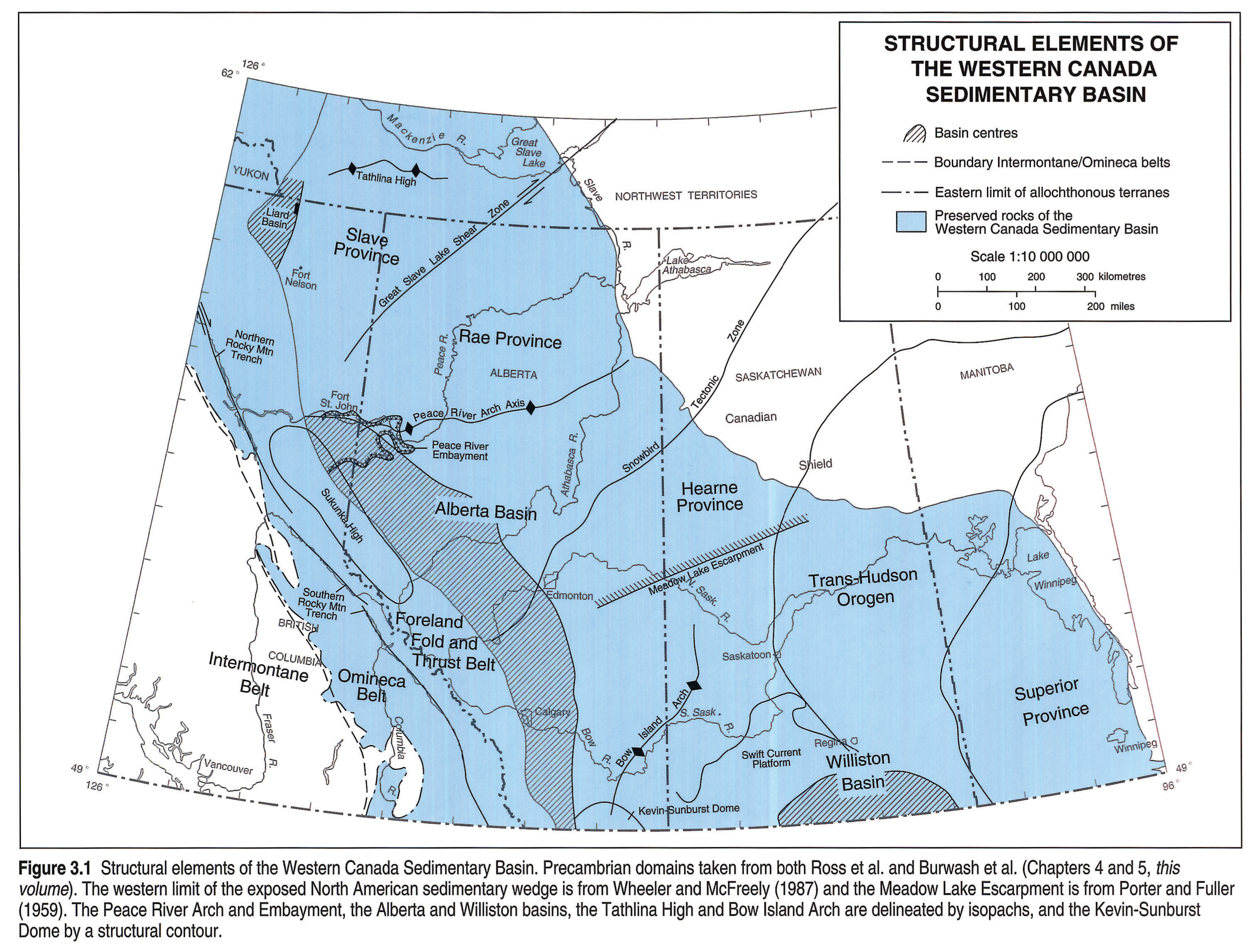
The WCSB comprises the eastern Canadian Cordillera and two major sedimentary basins: a northwest-trending trough in front of the Cordilleran Fold and Thrust Belt (extending eastward to the Canadian Shield) called the Alberta Basin; and the cratonic Williston Basin, centered in North Dakota and extending into southern Saskatchewan and southwest Manitoba (Fig. 3.1). These two features are separated by a broad northeast-trending positive element, which includes the Bow Island Arch. The arch was a subtle, mildly positive structural element in the late Paleozoic, and became more clearly defined in the Mesozoic and Cenozoic. At the southwestern end of the Bow Island Arch is the Kevin-Sunburst Dome, within which there are Tertiary intrusives.
The western boundary of the WCSB is here defined by the western limits of the exposed and deformed sediments of the ancestral North American margin, equating to the eastern limits of the allochthonous terranes, and normally located near the boundary between the Omineca and the Intermontane belts of the Cordillera. The boundary between the Omineca Belt and the Rocky Mountain Foreland Fold and Thrust Belt is the Rocky Mountain Trench, which continues northward into the Tintina Fault. For mapping convenience the southern limit of the WCSB in this chapter is normally taken to be at the Canada-U.S.A. border. The northern limit of the WCSB is defined by the Tathlina High in the Northwest Territories.
Strata of Middle Proterozoic to Cenozoic age thicken from an erosional zero edge in the northeast to more than 20 km within the Cordillera. Within this wedge, the Peace River Arch was a prominent east-northeast-trending topographic high in Cambrian to Late Devonian time that subsequently became, in part, the site of a faulted basin (the Peace River Embayment) in Mississippian to Permian time.
The Middle Jurassic to Eocene compressive deformation of the western edge of the WCSB formed the Cordilleran structural elements - the Foreland Fold and Thrust Belt and the Omineca Belt - deforming Middle Proterozoic to Eocene strata. Compressive deformation was followed by regional extension, and consequent deposition of Oligocene strata in the Flathead Valley Graben (southeastern British Columbia). The loading of the North American craton and the creation of western source areas during formation of the Cordilleran Foreland Fold and Thrust Belt greatly affected the Mesozoic and Cenozoic evolution of the entire WCSB.
Estimated post-mid-Jurassic shortening of 170 km across the Rocky Mountain Foreland Fold and Thrust Belt in southern British Columbia and Alberta includes 150 km since the mid-Cretaceous (Price and Fermor, 1984). Tectonic style and grain, thrust sheet thickness, and the nature of the displacement all change to the north in response to the following factors: changes in the lithological character of the deforming sedimentary prism; greater shortening of supercrustal rocks in the Bowser and Sustut basins of the Intermontane Belt (Evenchick, 1991); and increased lateral displacement along the Northern Rocky Mountain Trench fault system.
Structural features are, however, not restricted to the mountains. For example, in the Fort Macleod area of southernmost Alberta, there are a series of horsts and grabens. At the north end of the Alberta Basin, the Liard Basin is a dramatic feature in northeastern British Columbia and the Northwest Territories, bounded on the east by the Bovie Lake fault and fold complex. Also in the north, between the Peace River Arch and the Tathlina Arch, is the northeast-trending Hay River Fault and coincident Great Slave Lake Shear Zone (Fig. 3.1), which has up to 700 km of dextral displacement in Lower Proterozoic basement rocks. Vertical displacement and (possibly) horizontal offset are present in Phanerozoic strata near the Hay River Fault, but these are difficult to substantiate without geophysical data.
Apart from compaction and drape structures over reefs or other competent rock bodies, which are not discussed in any detail here, other "structural features" in the plains component of the WCSB include meteorite impact craters, and salt and carbonate dissolution structures. Several probable impact craters have been studied in the WCSB; all have faults or fractures near their sub-circular, raised perimeters and some have a central uplift. At Viewfield in Saskatchewan (Tp 7 R 7 W2M), there is a probable impact location which is 6 km wide and contains fractured Mississippian carbonates (Sawatzky, 1975). Other possible astroblemes are discussed in Burwash et al. and Norford et al. (Chapters 5 and 9, this volume).
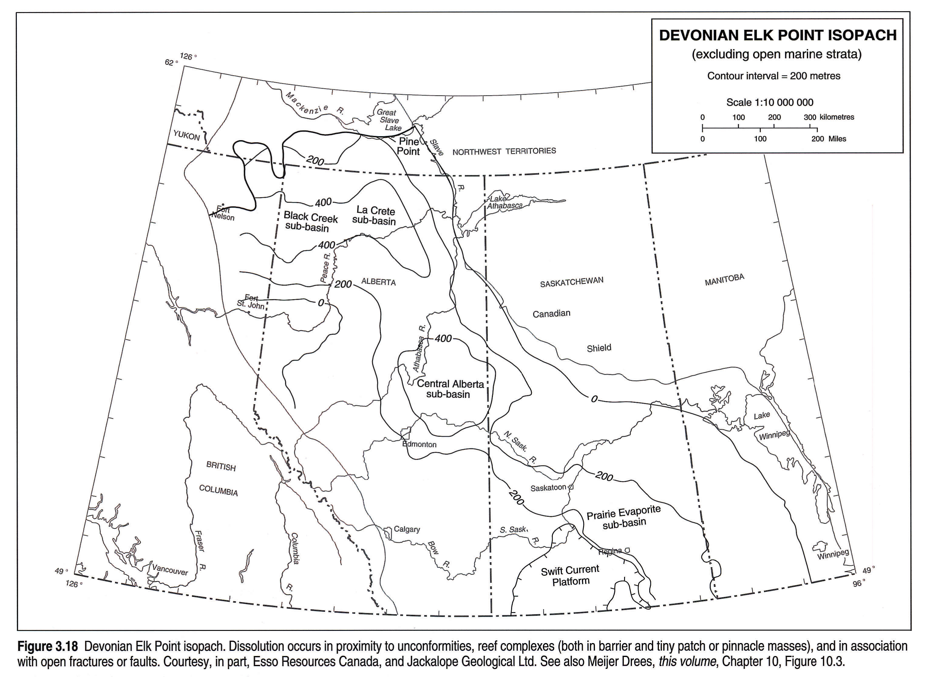
A variety of solution features are present in the basin. For example, dissolution of Devonian Upper Elk Point salt has occurred around reefs of similar age. The timing of dissolution varies and has been interpreted from seismic and subsurface well information. Dissolution of Devonian salt is also evident at the sub-Mesozoic unconformity, controlling to some extent the variation in the thickness of overlying Cretaceous strata as well as the relief on post-Cretaceous surfaces in the eastern and northeastern WCSB. Karst topography is present on several erosional surfaces.
In terms of present-day structural features, adjustment along pre-existing fault planes is undoubtedly occurring and is expressed as geomorphological trends: lineaments on the plains commonly reflect salt solution trends and deep faults. In the Cordillera, the amount of seismic (earthquake) activity recorded throughout this century is low - between 54 and 60°N (Milne et al., 1978).
Phanerozoic Summary
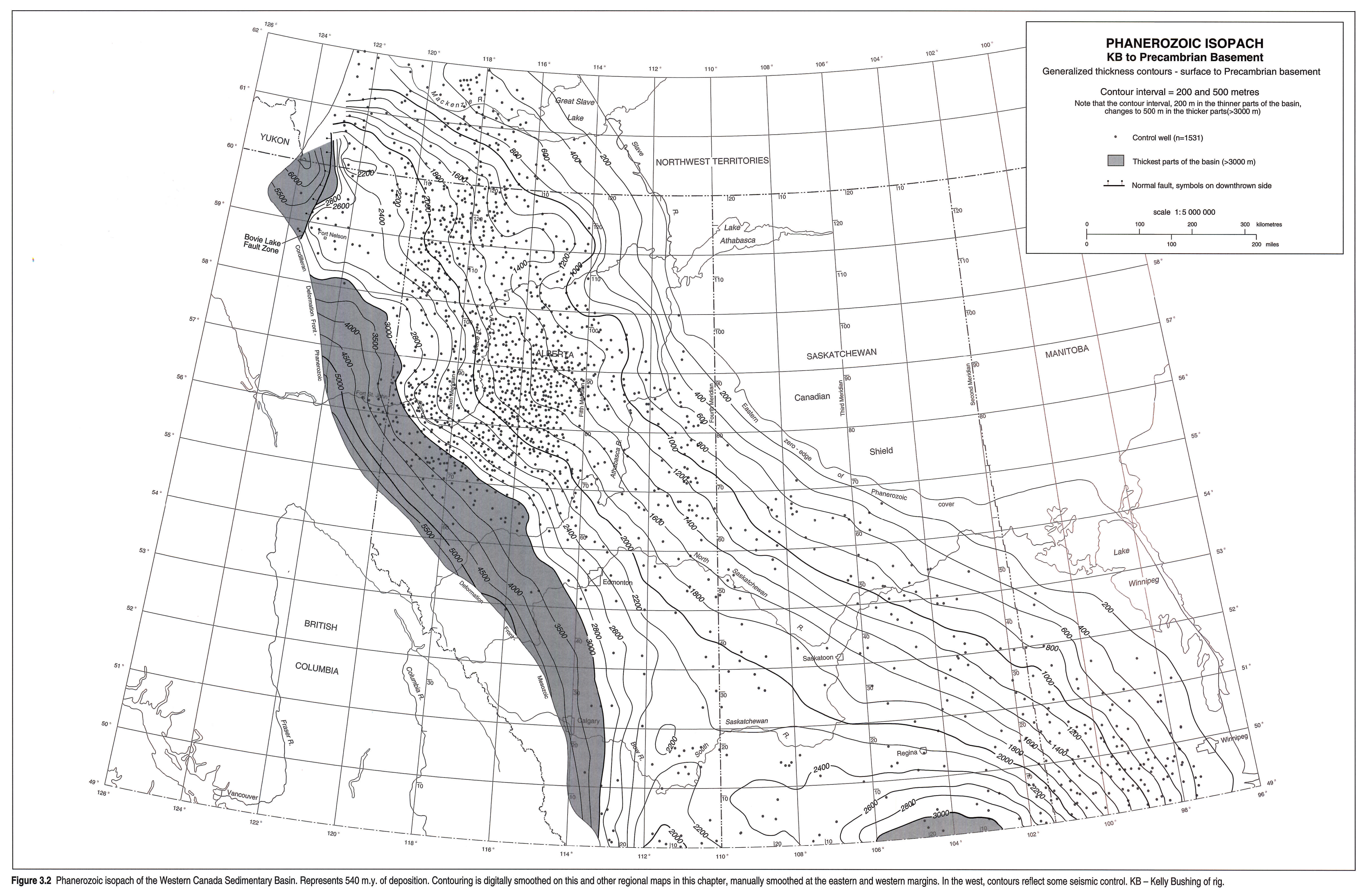
The Phanerozoic sedimentary wedge (Fig. 3.2) thickens southwestward from the exposed Canadian Shield to a preserved thickness of over 6 km east of the deformed belt in the Liard Basin, and southward to over 3 km in the Canadian portion of the Williston Basin. The latter was centered in North Dakota, but individual systems had different geographic depocentres, commonly within a circle of radius 110 km. In contrast to other intracratonic basins in North America, (Hudson Bay, Michigan and Illinois basins), the Williston Basin was periodically connected to the proto-Pacific ocean to the west through the northern United States, but became isolated in the Late Jurassic during the Cordilleran Orogeny.
Anomalies in the Phanerozoic wedge include the Peace River Arch, the Swift Current Platform and the Bow Island Arch (Fig. 3.1). One of the less obvious isopach anomalies is the thinning around Fort Nelson, in British Columbia, which was a tectonically positive element throughout the Phanerozoic (Fig. 3.2).
Periodically separating the Alberta and Williston basins (Fig. 3.1) was a positive area comprising the Bow Island Arch (Williams and Burk, 1964) and the Swift Current Platform, which formed the locus of intermittent, broad, low-relief topographic highs throughout the Phanerozoic (Kent, 1987). The northeast-trending Bow Island Arch is structurally distinct from the more complex Sweetgrass Arch of Montana, which has a northwest trend and consists of a South Arch and a North Arch (the Kevin-Sunburst Dome) separated by the possibly dextral northeast-trending Pendroy Fault. The Sweetgrass Arch may have been contiguous with "Montania" of the early Paleozoic.
Deep well control becomes sparse toward the mountains, but in the Canadian Rockies the Cambrian to Cretaceous interval thickens to the west. Within the fold and thrust belt, much of the Phanerozoic section has been removed by uplift and erosion, yet Paleozoic strata attain thicknesses of over 8 km. West of the Rocky Mountain Trench, subsurface data are minimal but surface stratigraphic data suggest that there may have been a number of margin-parallel sub-basins along the western edge of the North American Craton (see for example Struick, 1987).
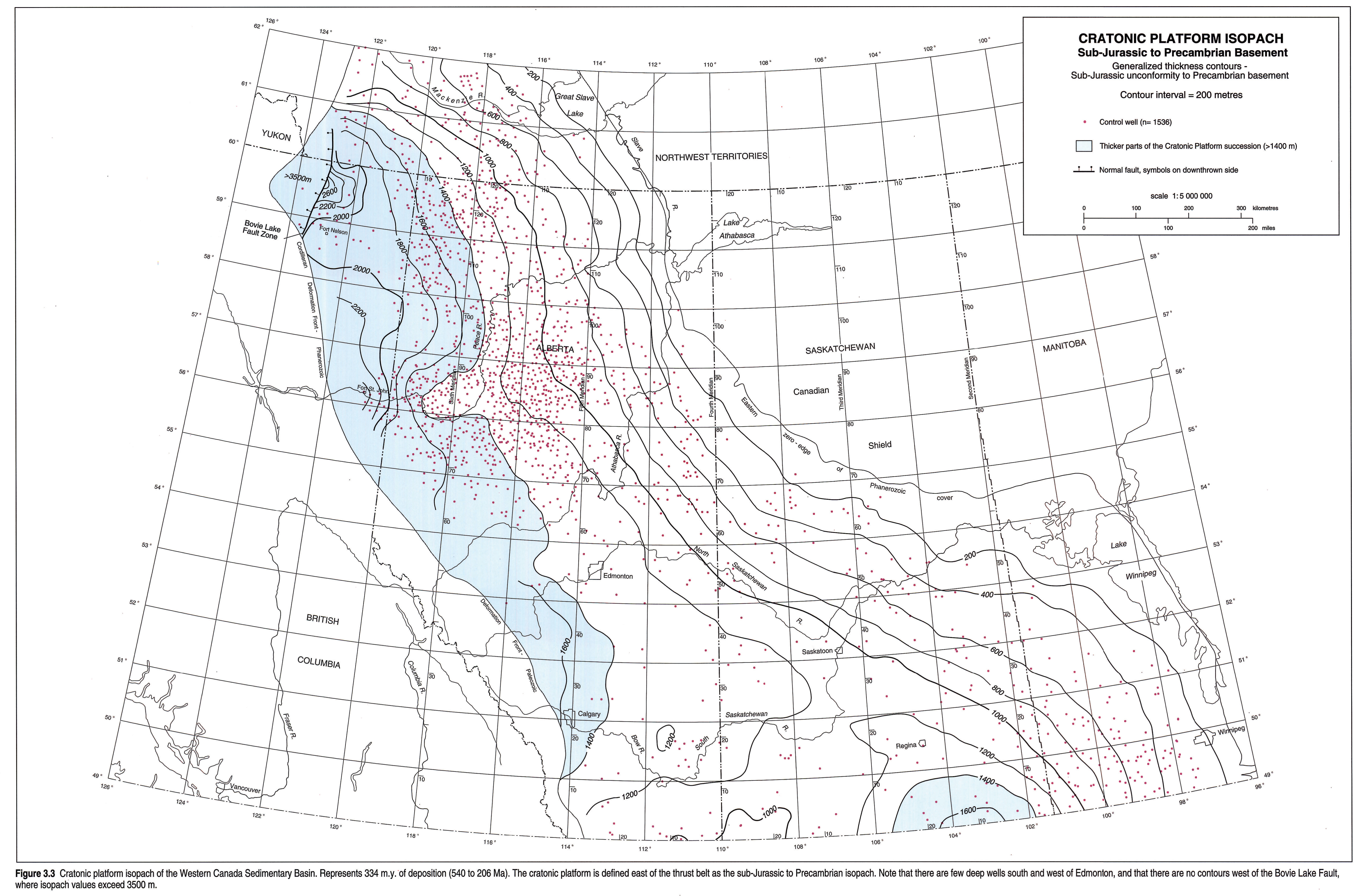
Cratonic Platform: Architecture - Cambrian to Middle Jurassic
The Paleozoic and earliest Mesozoic sequences (Fig. 3.3) were dominated by extensional tectonics and typified by the presence of an open ocean to the west. "Cratonic Platform" depositional sequences ended in Middle Jurassic time, about 158 million years ago. The cratonic platform succession can be described in terms of two divisions: the Sauk "Cambrian and older" sequence of Sloss (1963, 1988), and the remaining succession, encompassing three of Sloss's Paleozoic sequences (Tippecanoe, Kaskaskia and Absaroka). The preserved sub-Jurassic rocks (Fig. 3.3) are thickest north of 55°N, particularly north of the Peace River Arch (Figs. 3.1, 3.4 left pane, 3.4 right pane). Although several systems are well represented throughout the WCSB, the Ordovician and Silurian strata of the plains are best preserved in the Williston Basin, and the Triassic is thickest in the northwest. The Cambrian to Jurassic platform sequences are interrupted by numerous widespread unconformities, which generally become less pronounced west of basin hinge-lines. Early Paleozoic sedimentation was affected by local high blocks, presently located within the Cordillera.
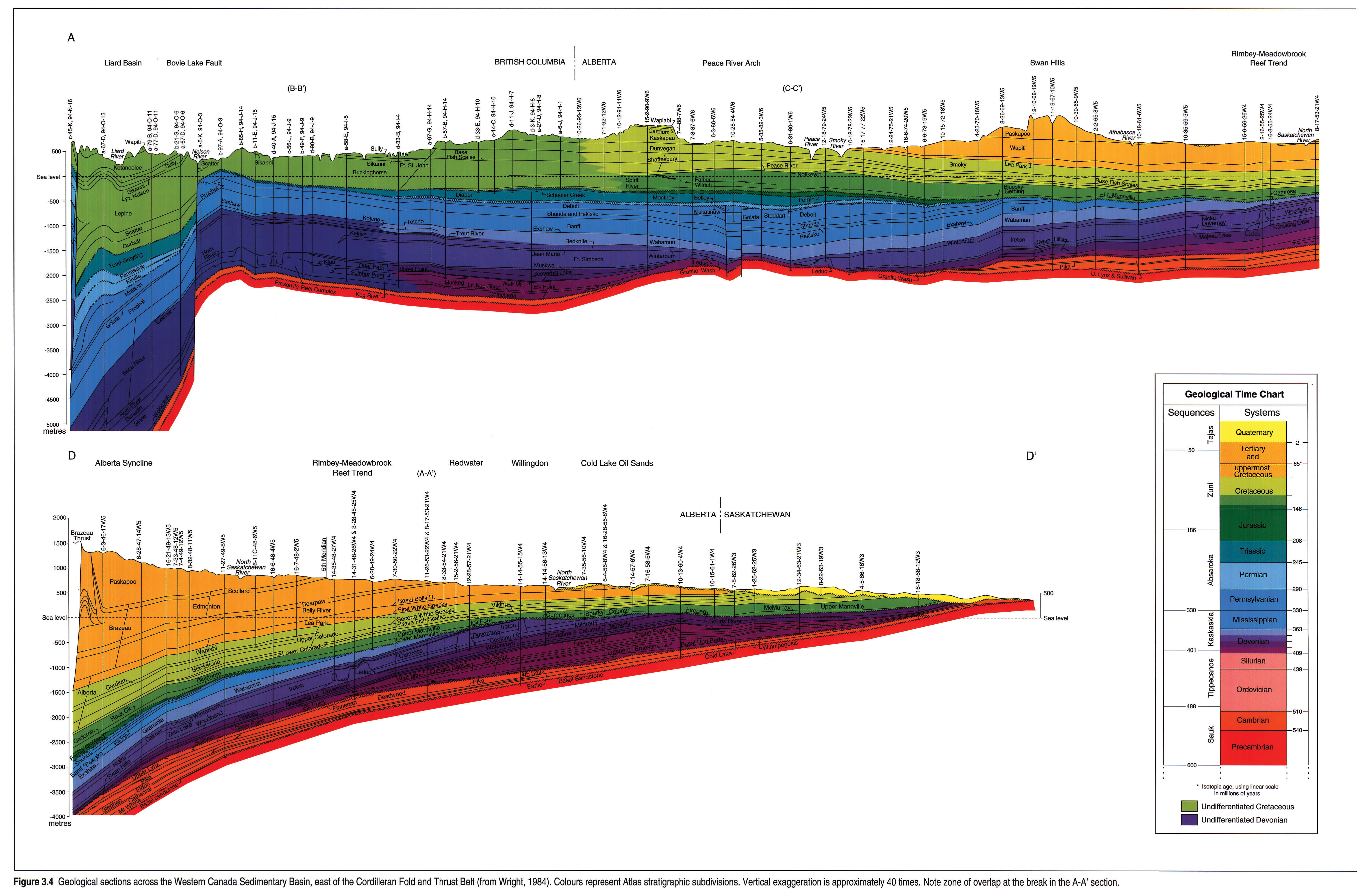
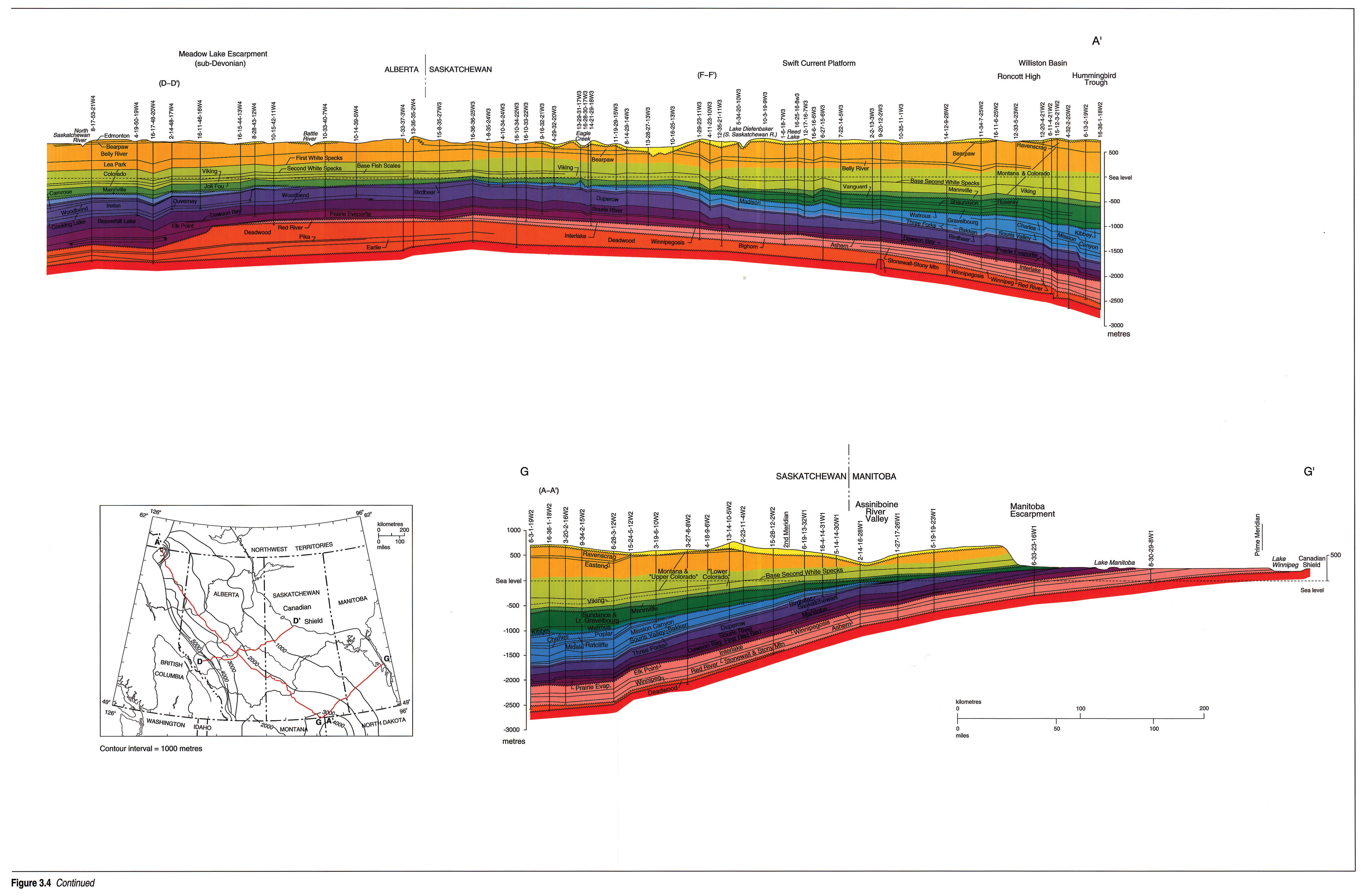
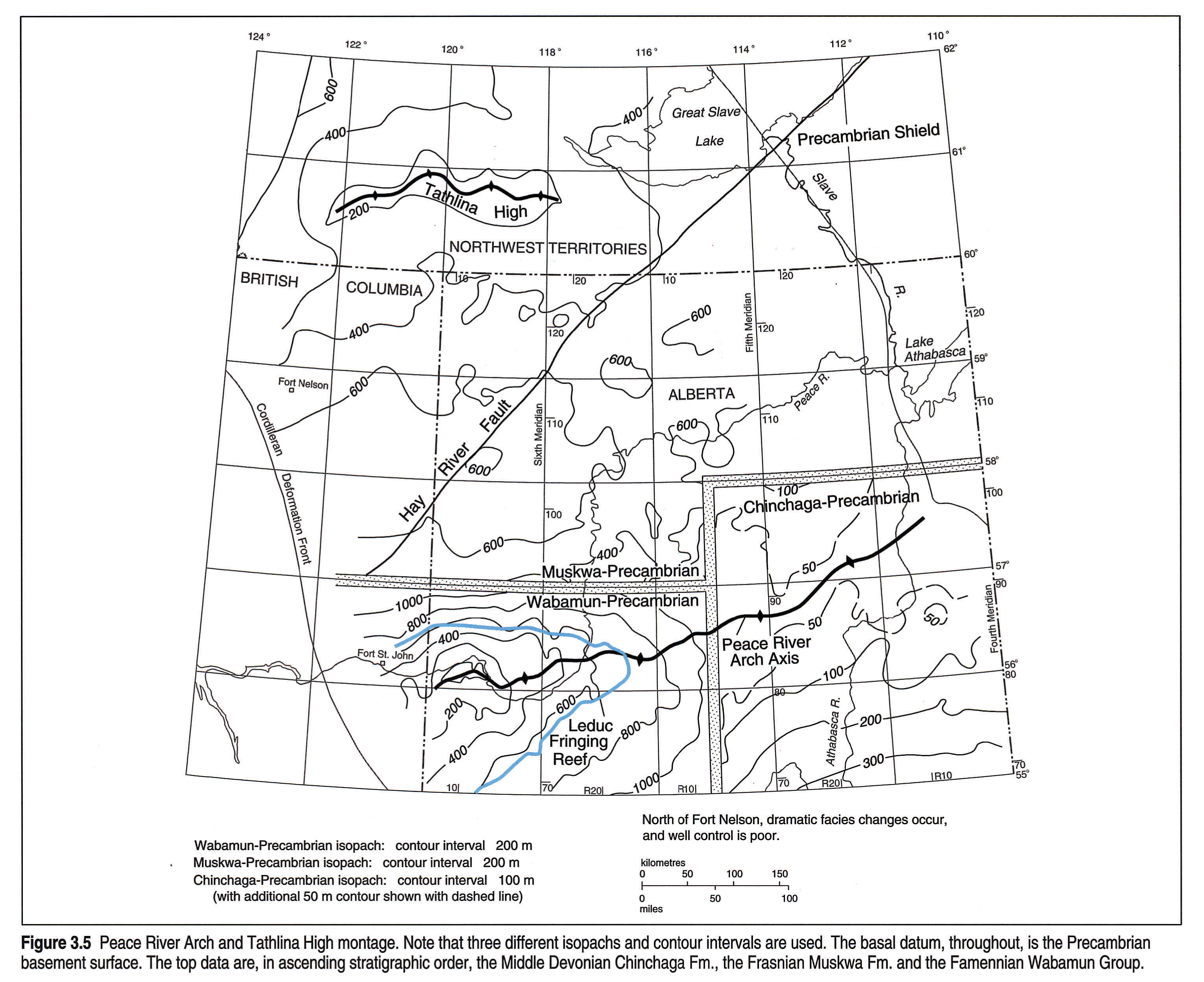
The asymmetrical Williston Basin is well defined by thick Paleozoic sediments (Figs. 3.2, 3.3, 3.11 and Kent and Christopher, this volume, Chapter 27). Eastward transgression of the Cambrian sea is represented by the clastics-dominated Upper Cambrian Deadwood Formation; the latter shows thinning over Upper Cambrian positive elements such as the Nesson and Cedar Creek anticlines in the U.S.A. Across the Cedar Creek Anticline, the entire Devonian section is missing, primarily because of erosion. The Swift Current Platform and Meadow Lake Escarpment (Fig. 3.1) were active during Silurian time. Porter and Fuller (1959) also recognized Silurian uplift on the eastern margins of the Williston Basin. Uplift of the Transcontinental Arch was synchronous with the establishment of the Middle Devonian Elk Point Basin, the axes of which can be traced from the Northwest Territories and northeastern British Columbia, through the La Crete and Prairie Evaporite sub-basins into north-central North Dakota. The topographic highs of the Peace River Arch and the independent, 320 m high Meadow Lake Escarpment (Figs. 3.1, 3.4 left pane, 3.4 right pane, 3.5), and the West Alberta Ridge, had profound effects on Devonian deposition, but the impact of basement features on Devonian reef growth varies from area to area. The Meadow Lake Escarpment lies above the Precambrian Hearne Province of the Canadian Shield and could be a purely topographic feature, although it may be associated with the Stanley Fault, mapped to the east on the exposed shield. This sub-Middle Devonian escarpment forms the northwest erosional limit of several lower Paleozoic units and provides the relief for the southern depositional limit of the Middle Devonian Lower Elk Point evaporites. Middle Devonian Upper Elk Point strata blanket the escarpment.
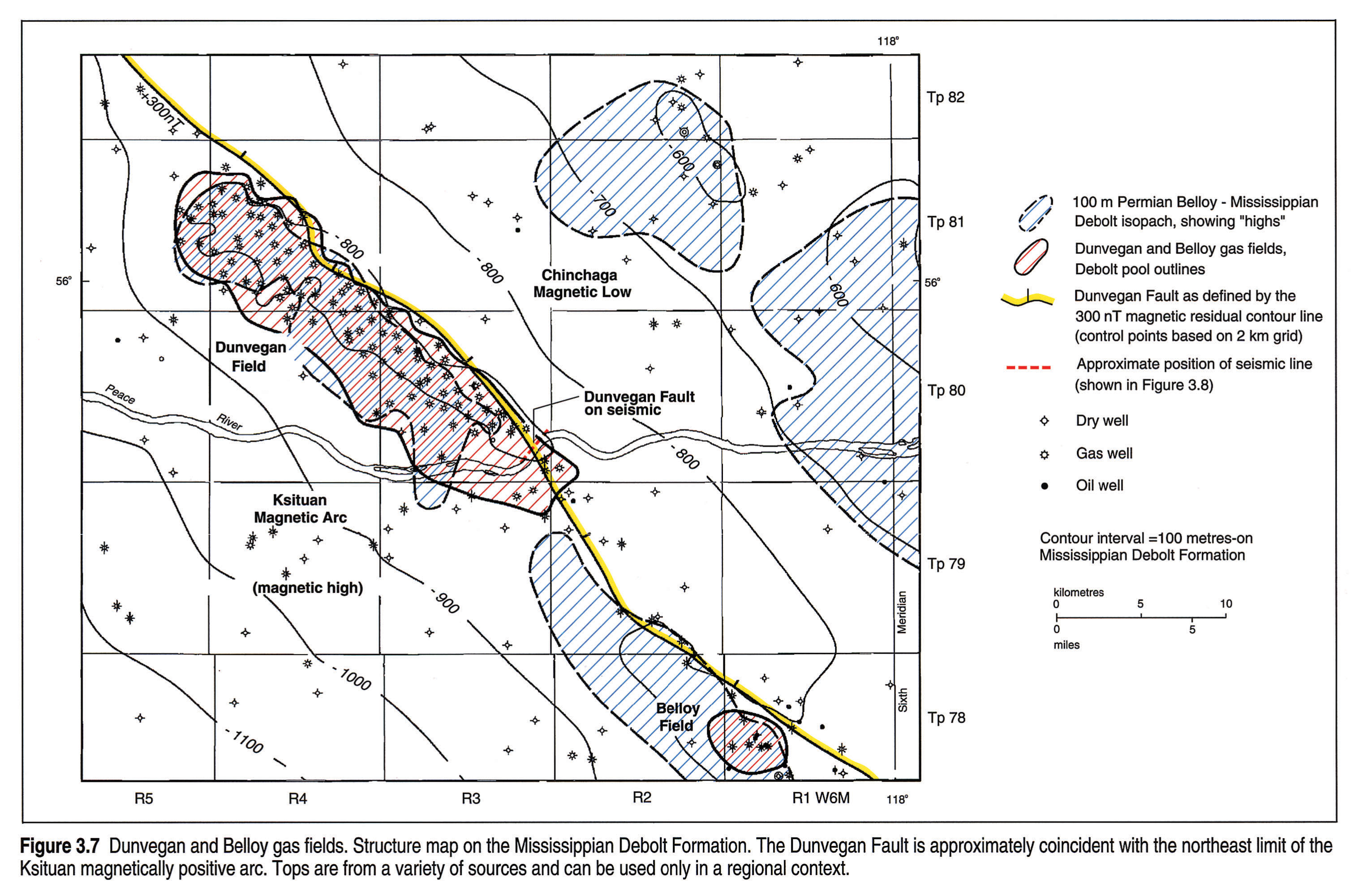
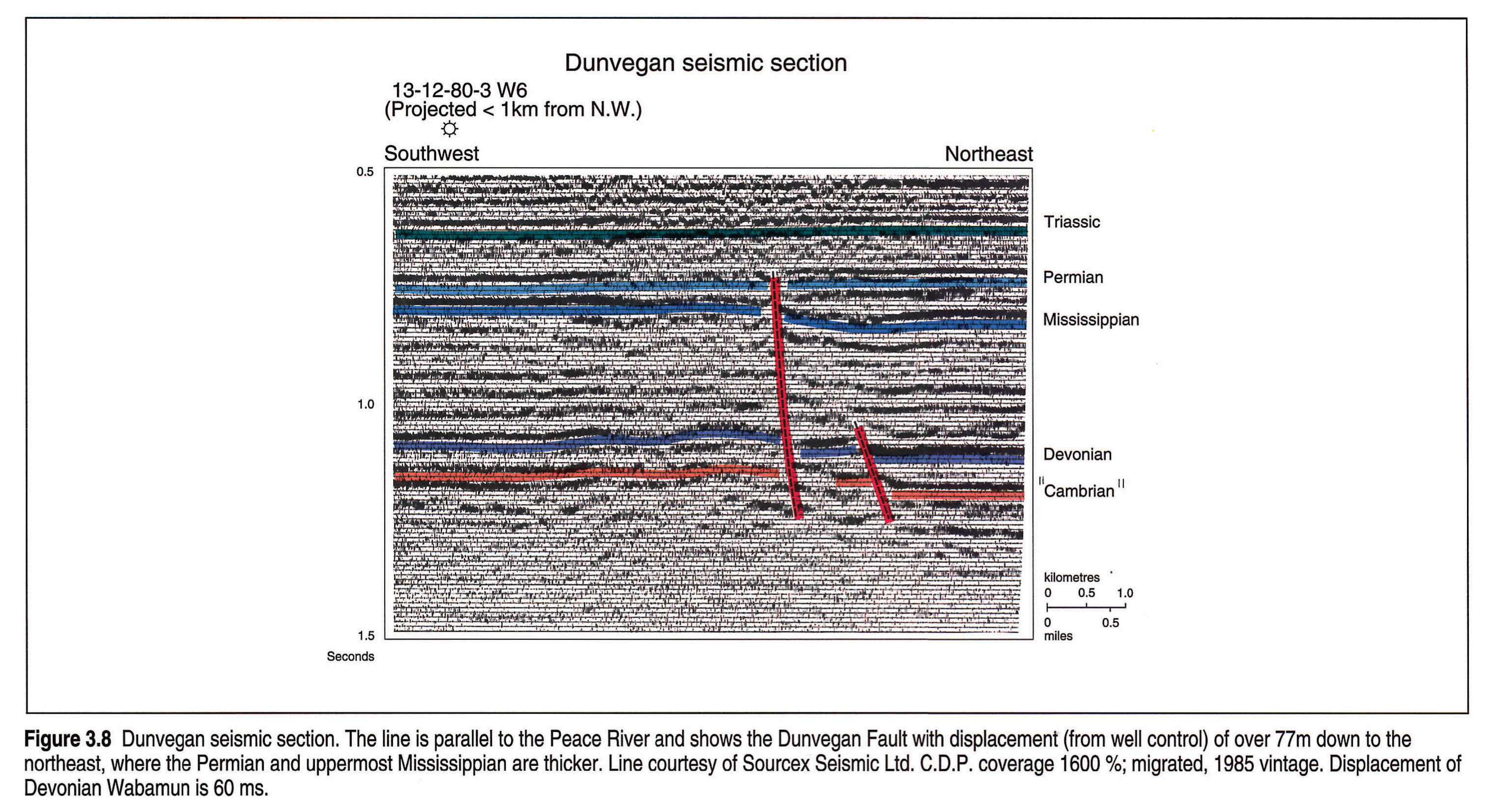
Coincident with the Late Devonian-Mississippian Antler Orogeny of the U.S.A., extensional tectonics produced the Liard Basin (Figs. 3.1, 3.2) and the east-west oriented Peace River Embayment (Fig. 3.6) containing the similarly oriented Fort St. John graben (see Barclay et al., 1990). Orthogonal faults are associated with the graben. Similar grabens and orthogonal faults are present within the thrust belt (Richards, 1989). The Dunvegan Fault (Figs. 3.6, 3.7, 3.8) near the eastern end of the Peace River Embayment was active primarily in Late Mississippian, Pennsylvanian and possibly Permian time. It provides an example of the reactivation of a boundary between two Precambrian elements, the Ksituan magnetic high and the Chinchaga magnetic low (Fig. 3.7). The 88 km long Dunvegan Fault has a northwest orientation and is parallel to many other lineations in northern Alberta and British Columbia, some of which are also identifiable as present-day topographic lineaments.
The Carboniferous Prophet Trough of Western Canada (Richards, 1989) can be mapped from the Antler Foredeep of the western United States northwest to Alaska, and straddles the present-day Rocky Mountain Trench. Henderson (1989) showed that the Prophet Trough existed into the Permian (the Ishbel Trough). Exposed in the Cordillera are several other features, such as the Sukunka High (Fig. 3.1) which extends from near Jasper to the Peace River area and was active from earliest Middle Tournaisian to earliest Permian (about 70 m.y.).
Depositional (or at least isopach) strike of Paleozoic strata in southernmost Alberta was east-west, changing to northeast and eventually north-northwest by early Mississippian time. The Mississippian has a particularly well defined depocentre in North Dakota but depositional centres for individual units of the Carboniferous Madison Group clearly vary. Within the Williston Basin, Permo-Pennsylvanian strata are preserved only in the deeper southern areas. The Bow Island Arch became an important barrier between the Alberta and Williston basins in Triassic to Late Jurassic time (Christopher, 1987), isolating the more evaporitic Williston Basin (Kent and Christopher, this volume, Chapter 27). Thin Mississippian strata beneath sub-Jurassic erosional surfaces indicate the positive axis within the Arch, which at that time plunged southwestward.
Foreland Basin: Architecture - Middle Jurassic to Oligocene
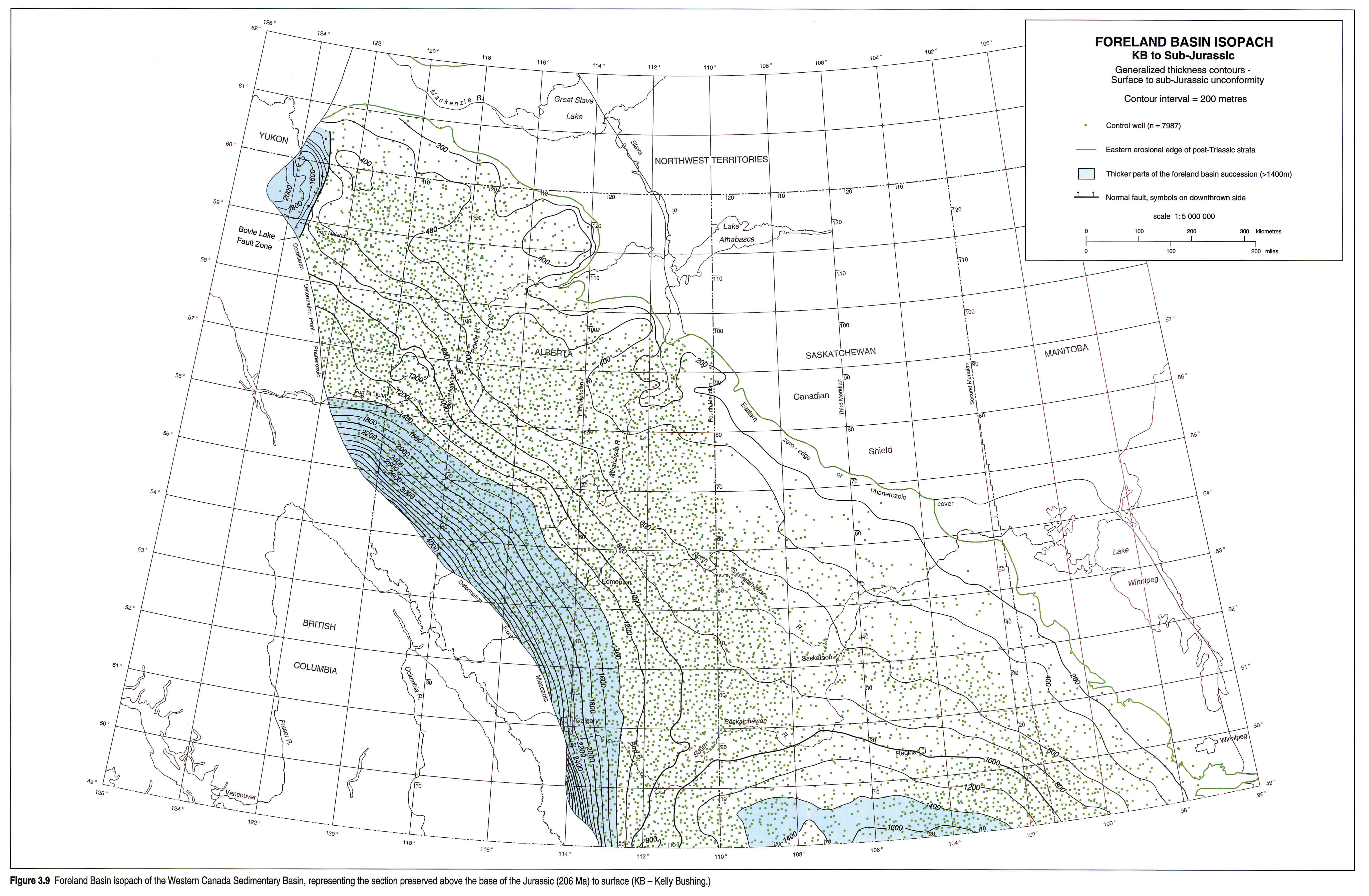
The foreland basin (Fig. 3.9) contains the Zuni and Tejas sequences (Sloss,1988). Because ground elevation, or rather, kelly bushing elevation, has been used in mapping, the isopach map includes Miocene and Pliocene strata as outliers, as well as glacial deposits. In the northeast parts of the foreland wedge, irregular thicknesses are due to present-day erosional outliers, such as the Swan Hills (Fig. 3.4 left pane, Fig. 3.4 right pane), Caribou Mountains, and Cypress Hills. The foreland basin sequences form a thick (up to 4000 m) arcuate band of sediment that is best developed south of 56°N (Tp 81) and west of the Bow Island Arch. The foreland basin formed as a consequence of deformation along the western edge of the North American Craton, which began in the late Early Jurassic with the accretion of exotic terranes from the Pacific. Marked subsidence of the foreland basin occurred in the Kimmeridgian more than 20 m.y. after the initial collision, deformation and metamorphism, suggesting that this early deformation occurred mainly subsea and well outboard from the thick North American craton (McMechan and Thompson, in press). Immense loading of the North American craton as a consequence of structural thickening and overlap during compressive deformation caused the depression and flexure of the craton and formed the foreland basin (Price, 1973; and this volume, Chapter 2). Erosion of newly uplifted western source areas helped fill this trough with sediments.
The orogenic events have west-to-east chronology and a peripheral bulge can be expected to have moved eastward with each major advance of the east-verging thrusts and folds. The bulge was possibly arrested periodically by anomalies over underlying structures.
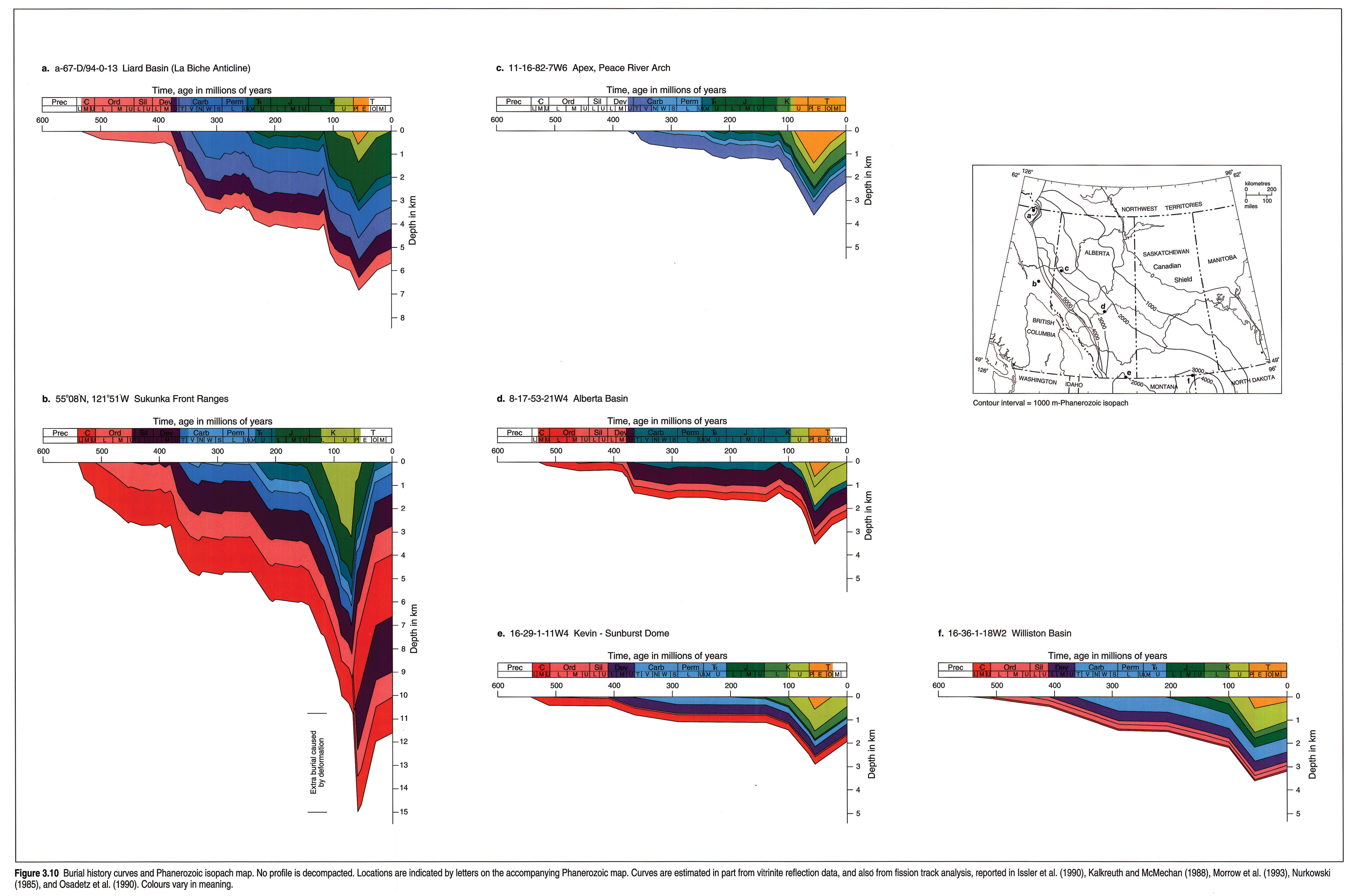
Renewed uplift and consequent erosion immediately postdated the termination of compressive deformation in the Middle Eocene. Middle Tertiary uplift is displayed on the burial history curves (Fig. 3.10). Coal rank data suggest that this uplift increased from approximately 1 km in the east to over 2.5 km at the western edge of the undeformed basin near 54°N (Kalkreuth and McMechan, 1984; Nurkowski, 1984, and Osadetz, pers.comm.), whereas the maximum erosion north of 56°N was less than 1 km (Kalkreuth and McMechan, 1988). Within the Rocky Mountains, over 4 km of Early to early Late Oligocene uplift and erosion are recorded by the changing provenance of clasts in the Oligocene Kishenehn Formation of the Flathead Valley graben (McMechan, 1981). Thus the Eocene foreland basin was substantially deeper than, but similar in form to, the present foreland basin. For example, the foreland basin strata in southern Alberta (near Fort Macleod, Tp 8 R 23 W4M) still measure over 3000 m despite post-Tertiary erosion of 1900 m (Nurkowski, 1984 and pers. comm.).
The thick southern part of the foreland basin sequences of the Alberta Basin terminates (to the north) within the site of the earlier Peace River Embayment (Figs. 3.6, 3.9, and Price, this volume, Chapter 2). Marked changes in coal rank suggest that the area was structurally active in the Tertiary (Kalkreuth and McMechan, 1988). The contrast in depositional strike between the Lower Cretaceous beds (variable, but approximately north-south) and the post-Base Fish Scales marker succession (east-west in British Columbia) is remarkable. The thickening of the Lower Cretaceous Upper Mannville Group is centred on the site of the Carboniferous Peace River Embayment, and the control may also have been exerted on the orientation of the younger Paddy and Cadotte members of the Cretaceous Peace River Formation (Leckie et al., 1990). Depositional trends in the Paddy-Cadotte sequences are subparallel to the axis of the Late Devonian expression of the Peace River Arch, and indeed almost coincident with the crest of the high where the Devonian Wabamun Formation is absent (Figs. 3.5, 3.6,, 3.10c). The Liard Basin also shows a thick section of Cretaceous strata that thins abruptly eastward at the Bovie Lake Fault (Figs. 3.4 left pane, 3.4 right pane, 3.10a).
The Bow Island Arch (Figs. 3.1, 3.9, 3.10e) may, in part, provide an example of interference between the Alberta foreland basin peripheral bulge and the rim of the Williston Basin (Beaumont, 1981; Wu, 1991). The axis of the Bow Island Arch can be defined by the 1000 m contour of the foreland basin-fill isopach (Fig. 3.9). Circular intrusions are present in the northeast quadrant of the Kevin-Sunburst Dome (Foley, 1972) and provide some of the rare exposures of igneous intrusions into sediments of the WCSB. The intrusions occurred at a time of widespread extension and volcanism within the Cordillera which immediately postdated compressive deformation of the Omineca and Rocky Mountain Foreland Fold and Thrust belts. Intrusions in the Sweetgrass Hills of Montana, near the Alberta border, and the exposed dykes within Alberta (Williams and Dyer, 1930) range in age from 54 to 50 Ma, according to Marvin et al. (1980), who also recalculated the age of the Minette Dyke at Pinhorn Butte in Alberta to be 49.7 Ma.
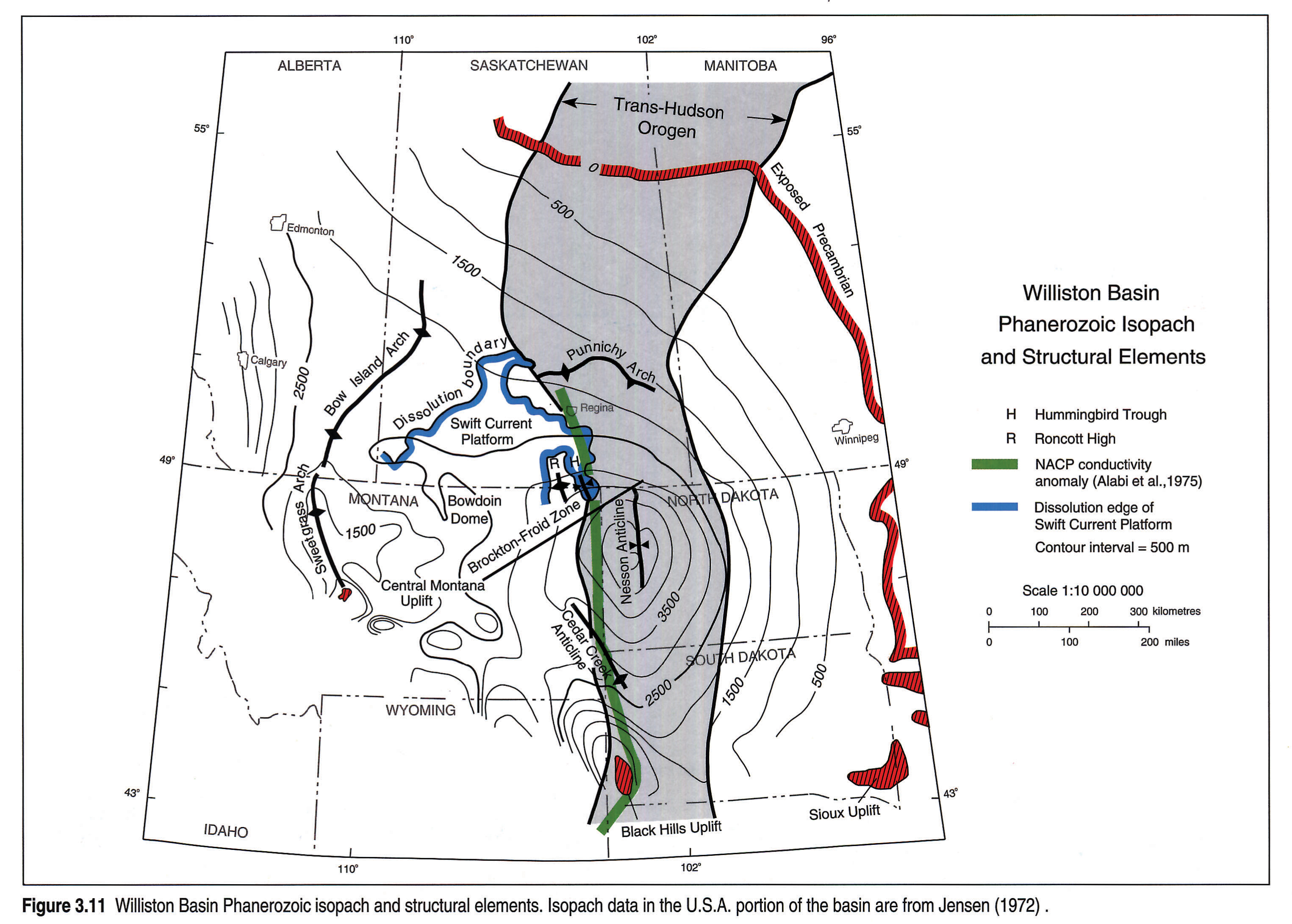
The Williston Basin (Figs. 3.4 left pane, 3.4 right pane, 3.10f, 3.11) continued to accumulate sediments in Mesozoic time. In Saskatchewan it has a significant east-west extension, not apparent in the basin's earlier history (Figs. 3.9, 3.12). The Punnichy Arch and the Swift Current Platform emerged near the northern and western margins of the Williston Basin (Fig. 3.11) in Late Jurassic time. Within Saskatchewan, the Punnichy Arch and the Bowdoin Dome (Fig. 3.11) were both positive during the Cretaceous, and fault movement persisted over Precambrian highs. Significant dissolution of Devonian salt continued throughout the WCSB (Fig. 3.11).
Cordillera
Summary
The western margin of the WCSB, now preserved in the Cordillera, has had a long tectonic history dominated by major episodes of extension. To what degree compressive tectonic events affected the western edge of the WCSB prior to Jurassic Cordilleran deformation is a subject of debate. Two thick (up to 20 and 9 km) Proterozoic sequences in the Cordilleran Fold and Thrust Belt are generally absent in the undeformed WCSB to the east. The older, Middle Proterozoic Belt-Purcell sequence marks the beginning of the filling of the basin and provides evidence of continental rifting and extension around 1500 to 1400 Ma which, at least locally, formed extremely attenuated continental or oceanic crust. However, it was continental rifting and separation associated with deposition of the Upper Proterozoic Windermere Supergroup that established the general position and trend of the proto-Pacific North American margin and the western edge of the WCSB. U-Pb zircon dates suggest extension was initiated between 770 and 730 Ma (see Hein and McMechan, this volume, Chapter 6). A major latest Proterozoic extensional (rifting) and thermal event (Bond and Kominz, 1984) controlled sedimentation in the up to 7 km thick lower Paleozoic succession. Restriction of thick Lower Cambrian sediments to the Fold and Thrust Belt is consistent with rifting and subsidence models. Tectonic history outboard from the proto-Pacific margin during the middle and late Paleozoic was complex and may have involved compressional as well as extensional events (see Richards, 1989). Within the WCSB, extension dominated, as evidenced by widespread block faulting in the Peace River Embayment and Liard Basin areas.
Compressive deformation began in the Middle Jurassic and ended in the Eocene, a period of about 120 m.y. During this time interval the deformation front migrated cratonward (eastward). This resulted in the migration of the tectonic load and the foreland basin axis, and progressive uplift and cannibalization of earlier deposits along the western flank of the foreland basin. These effects are illustrated in the burial history curves for the Sukunka River area (Fig. 3.10b). The rapid westward reduction in the duration of burial and maximum thickness of the foreland basin greatly decreased the maturation of underlying upper Paleozoic and Triassic strata in the Front Ranges as compared to the western edge of the plains (Kalkreuth and McMechan, 1988).
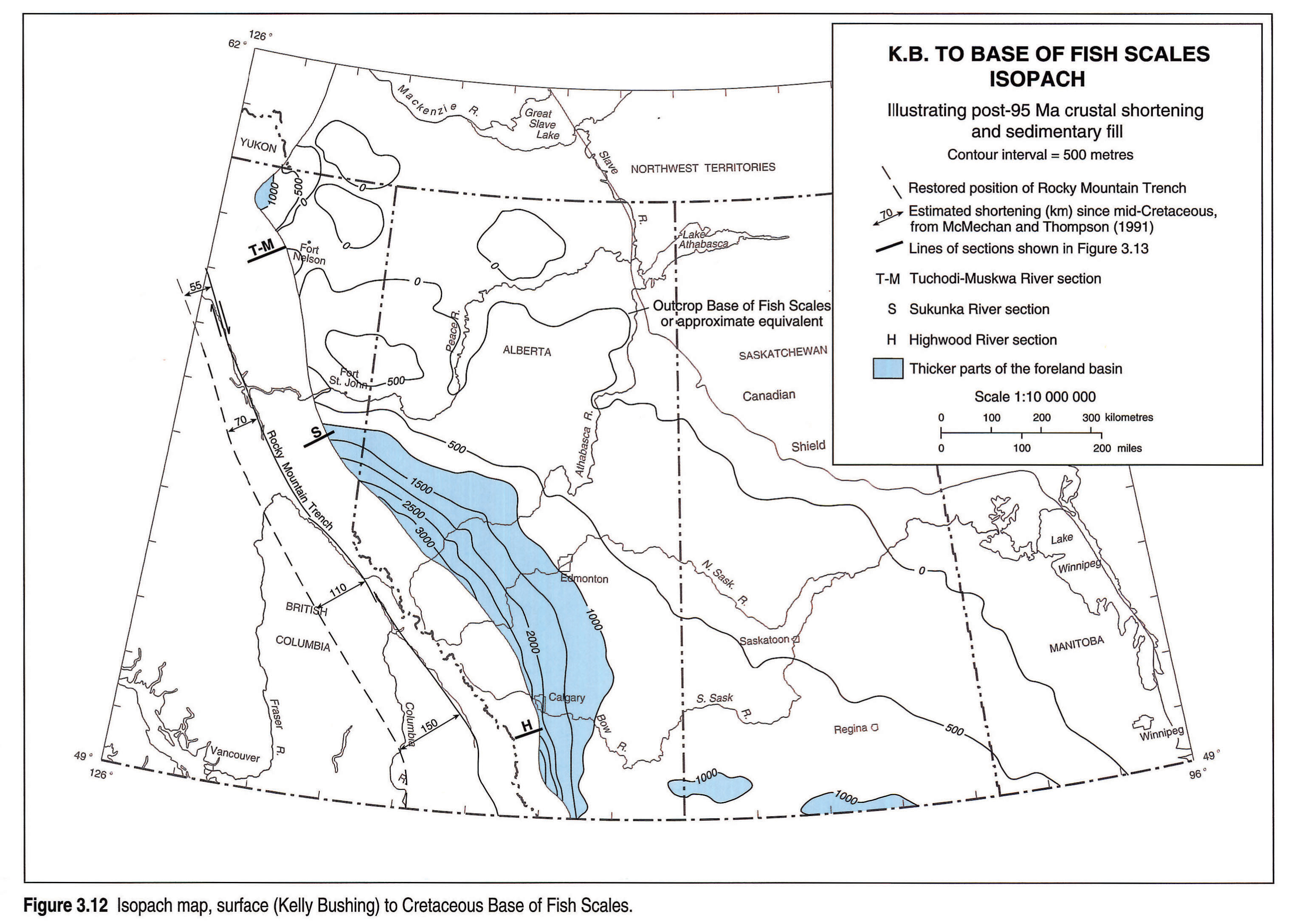
Estimated total shortening across the fold and thrust belt from the Rocky Mountain Trench to the eastern limit of deformation decreases from 170 km in the south to 70 km in northeast British Columbia, but then increases to over 150 km in the southern Yukon. The region of low total shortening in northeast British Columbia probably reflects three factors: 1) more North American intraplate shortening was accommodated within the Intermontane Belt (Skeena Fold and Thrust Belt, Evenchick, 1991) at this latitude than to the north or south; 2) more of the westernmost part of the WCSB occurred west of the Tintina-Northern Rocky Mountain Trench fault system in northeast British Columbia than in the Yukon; and 3) there was a real reduction in the amount of Late Cretaceous-Early Tertiary shortening from south to north. Estimated post-95 Ma (mid-Cretaceous, Base of Fish Scales) shortening decreases progressively northward from 150 km in the south to 55 km in northeastern British Columbia (Fig. 3.12) and 50 km in the southern Yukon and Northwest Territories (McMechan and Thompson, 1991). Price and Carmichael (1986) suggested that this change was related to the Tintina-Northern Rocky Mountain Trench fault system transforming the northern strike-slip displacement into compressive deformation in the south. Relative plate motion studies (e.g., Engebretson et al., 1985) suggest a more fundamental cause; more oblique plate convergence may have occurred in the north, where the Kula Plate interacted with the North America plate, than in the southern Farallon Plate interaction.
Fig. 3.12 compares the estimated post-mid-Cretaceous shortening with net post-mid-Cretaceous subsidence of the basin, utilizing the isopach from essentially ground surface to the Cretaceous Base of Fish Scales marker. The dip of the basin due to loading is not always coincident with the northeast-directed motion of the adjacent thrust sheets, yet observed westward thickening of the basin is consistent with foreland basin models. Locally, however, the north-south change in thickness of basin fill is far more abrupt than models predict. South of Fort St. John at 121°W, the isopach contours are oriented almost east-west, and there is an abrupt northward decrease in net subsidence that marks the north end of the thick Upper Cretaceous-Tertiary fill of the Alberta Basin. The axes of the Peace River Arch and Peace River Embayment coincide approximately with this change in direction (Figs. 3.5, 3.6) and this suggests significant north-side-up reactivation of structures associated with earlier arch and embayment tectonic controls. This reactivation of pre-existing transverse structures had a more pronounced effect on the along-strike basin form than the gradual northward decrease in the amount of time-equivalent shortening in the immediately adjacent fold and thrust belt (Fig. 3.12).
Structural Styles
The structural style of the fold and thrust belt was largely controlled by the lithological character of the deformed stratigraphic sequences. Thick, competent carbonate and/or sandstone successions favoured the development of thick thrust sheets. On the other hand, less competent interlayered shale and sandstone, or shale and carbonate successions, favoured the formation of folds between detachments. Locally, earlier-formed normal faults or basement ramps influenced Cordilleran structural development and trends.
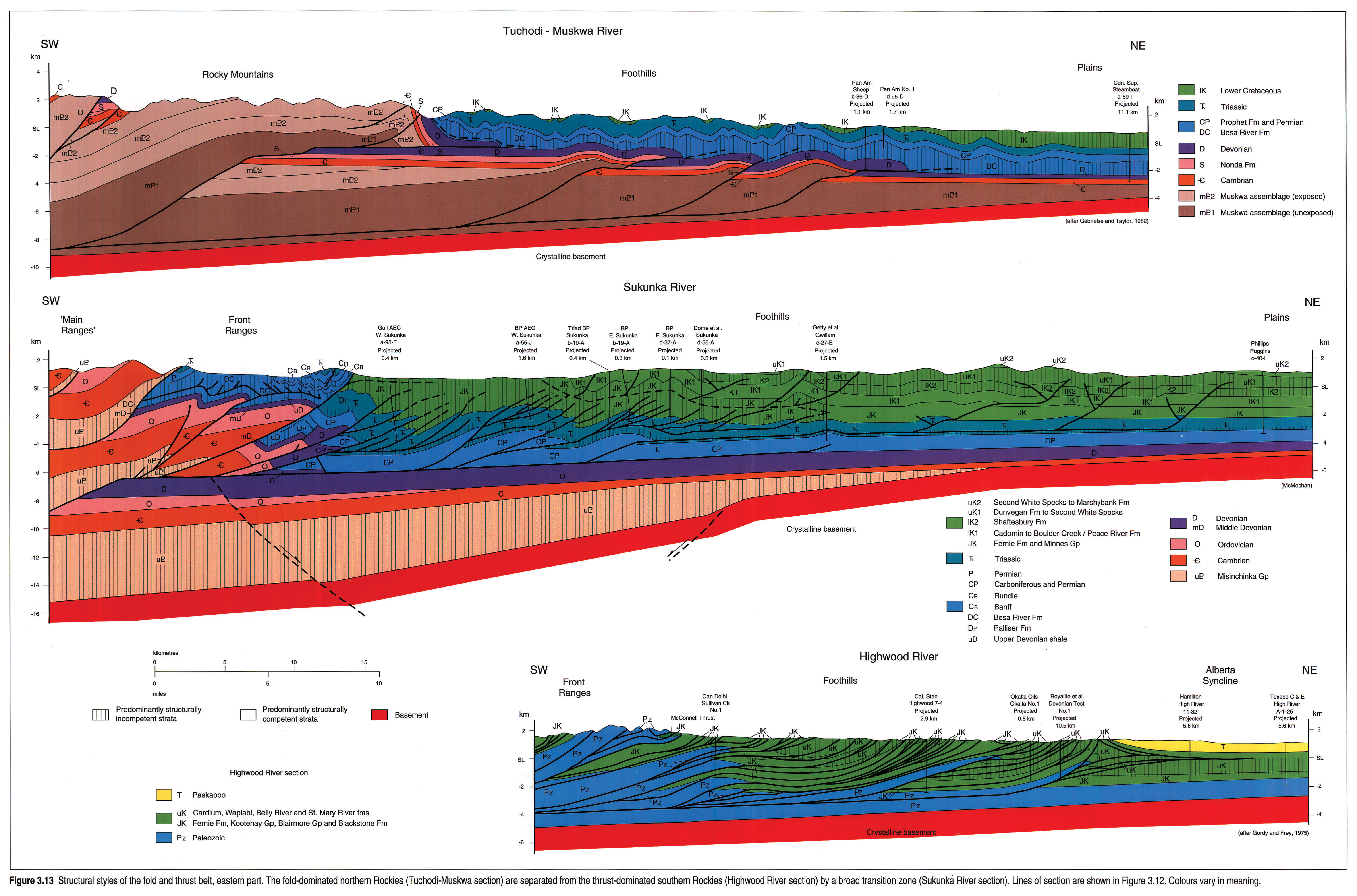
A northward change in structural style from thrust-dominated in the south to fold-dominated in the north reflects facies changes within the Phanerozoic section and a general northward decrease in competency of almost the entire section. A broad transition zone, with folds more common at the surface and thrust faults more common in the subsurface, occurs between Athabasca River and Williston Lake-Peace River. Structural cross sections (Fig. 3.13) illustrate structural styles for the eastern foothills part of the fold and thrust belt, where most of the deformed belt hydrocarbon exploration has been and will continue to be over the next decade. Significant variations in structural style across and along the western part of the fold and thrust belt were recently reviewed in McMechan and Thompson (1989) and are not discussed here.
Northeast-verging thrust faults in Mesozoic and Paleozoic strata characterize the southern foothills. The Highwood River section (Gordy and Frey, 1975; Fig. 3.13) is typical of the foothills south of Bow River (51°N), where Mesozoic clastic strata are cut by numerous thrust faults and Paleozoic strata by fewer. North of the Bow River, imbrication of the Mesozoic section is less intense. Strata near the leading edges of single thrust sheets or in thrust sheet stack-ups are targets for petroleum exploration (Fig. 3.13). A triangle zone or zone of underthrusting occurs at the eastern limit of deformation along most of the southern foothills (Jones, 1982). The resulting deformation of the overlying para-autochthonous strata produced the east-dipping west limb of the Alberta Syncline along the western edge of the essentially undeformed Alberta Basin (Figs. 3.4 left pane, 3.4 right pane, 3.13).
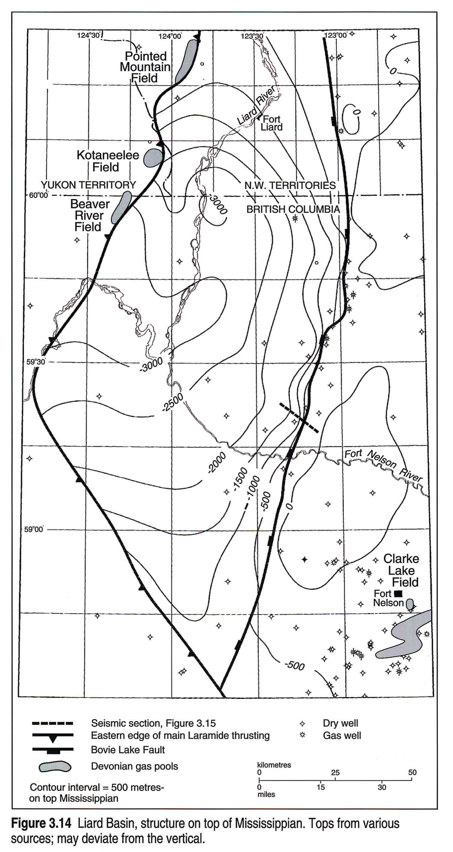
Large-amplitude box and chevron folds in upper Paleozoic and Mesozoic strata characterize the surface structural expression of the northern foothills, a marked contrast to the complex array of faults found in the southern foothills (Fig. 3.13). Seismic data show that small-displacement reverse faults with both east and west dips underlie some of the surface anticlines, even though none are shown in Gabrielse and Taylor's (1982) Tuchodi-Muskwa section (Fig. 3.13). Low-amplitude folds, developed in upper Paleozoic to Lower Cretaceous strata beneath nearly flat-lying Upper Cretaceous sandstone and shale, occur up to 200 km east of the physiographic northern foothills. Some of these structures result from the reactivation and partial inversion of grabens, filled mainly with upper Paleozoic sediments. Partial inversion of grabens oriented subparallel to the compressive orogen-forming stress field commonly occurs east of "regular" fold and thrust belt structures. The Bovie Lake Fault complex on the eastern side of the Liard Basin (Figs. 3.4 left pane, 3.4 right pane, 3.14, 3.15) may be related to this phenomenon.
Northern foothills folds formed above a regional detachment developed in a thick Upper Devonian and Mississippian shale succession. Underlying Devonian and older carbonates remained essentially undeformed across the eastern part of the subprovince. A few simple thrust faults are thought to deform these strata under the western part of the foothills (Fig. 3.13).
The transition zone between the thrust-dominated south and the fold-dominated north contains a variety of structural styles. To a large degree these reflect changes in structural competency of the deformed stratigraphic sequences. At Sukunka River (Fig. 3.13), the Front Ranges comprise complex, narrow folds formed in the interlayered competent and incompetent Upper Devonian to Triassic succession. These folds formed above a detachment in thick Upper Devonian shales. The underlying thick, competent Middle Devonian to Cambrian succession is mainly thrust faulted. In the western foothills, folded Lower Cretaceous strata at surface are separated by a detachment in the Jurassic and Cretaceous Fernie-Minnes succession from Triassic strata with a very different structural style of faulted folds and local imbricate thrust (duplex) complexes. Underlying Mississippian strata occur in relatively simple fault structures. The complex nature of the folded and faulted Upper Triassic reservoirs was described by Barss and Montandon (1981). A markedly different structural style occurs under the eastern foothills (Fig. 3.13). Barely deformed Upper Cretaceous Second White Specks and younger strata at the surface are underlain by broad, low-amplitude box folds formed by fault-bend folding and fault displacement transfer. Seismic data show that relatively small-displacement, northeast-verging reverse faults climb out of a detachment near the base of the Triassic and into an upper detachment in Upper Cretaceous Kaskapau shales. Small east-dipping antithetic reverse faults that commonly die out upward as folds are relatively common. The Cretaceous Minnes Group does not form an important detachment zone here, presumably because of eastward truncation and facies change to more structurally competent strata in the upper part of the Minnes Group.
Basin Architecture
Structural Framework
Some of the structural elements of the WCSB (Fig. 3.1) are associated with movements of the underlying basement. The texture and orientation of aeromagnetic data, integrated with age and lithological information, allow the basement east of the Cordillera to be subdivided into five, broad, Precambrian units (Fig. 3.1) ranging in age from 1.8 Ga to 2.8 Ga. From southeast to northwest they are as follows: the Superior Province, the Trans-Hudson Orogen, the Hearne Province (including the Cree Lake Zone), the Rae or Northwest Churchill Province, and the Slave Province (Ross, 1989). The Snowbird Tectonic Zone separates the Hearne and Rae provinces, and the Great Slave Lake Shear Zone separates the Rae and Slave provinces (see Ross et al., this volume, Chapter 4; Burwash et al., this volume, Chapter 5).
Beneath the eastern Williston Basin, the relatively young, north-south-trending Trans-Hudson orogenic belt (about 1.9 Ga) has been mapped utilizing aeromagnetic surveys (Fig. 3.11). Within the belt is the North American Central Plains (NACP) conductivity anomaly (Camfield and Gough, 1977). This anomalous electrical conductivity zone in the crystalline crust extends from the Black Hills Uplift of South Dakota northward into Saskatchewan (Fig. 3.11). Several salt dissolution features, including the Hummingbird Trough (Holter, 1969), appear to be related to the zone of anomalous conductivity. Parallel to the NACP anomaly and coincident with the north-south-striking Nesson Anticline of North Dakota is a high heat-flow anomaly (Majorowicz et al., 1988) with associated elevated thermal maturity of Paleozoic hydrocarbon source rocks (Osadetz et al., 1990).
Locally there is evidence of Phanerozoic geology being influenced by basement structures. The Great Slave Lake Shear Zone contains the Hay River Fault (Fig. 3.5) which affected Cretaceous strata and possibly influenced the deposition of the Devonian Elk Point Formation between the Rainbow oil field (58°30'N 119°W) and the Northwest Territories. According to Hoffman (1987), large-scale dextral transform movement of 300 to 700 km occurred until 1.9 Ga along the 25 km wide shear zone, which extends some 1300 km from northeast British Columbia through Alberta and into the Northwest Territories (Fig. 3.1). This shear zone is clearly visible on aeromagnetic maps and to a lesser extent on gravity maps. At its southwestern end, where magnetic changes are less obvious, it may be a composite of several smaller faults; this may also be true for the southwestern end of the Snowbird Tectonic Zone (Fig. 3.1).
There is little evidence of Mesozoic and Cenozoic transcurrent movement east of the Cordillera, but dextral movements have occurred throughout British Columbia, related to the oblique convergence of the Pacific plate with the North American plate. Gabrielse (1985) suggested that lower Paleozoic units along the western edge of the basin have moved northward 750 km or more along the Northern Rocky Mountain Trench and Tintina faults, between the Middle Jurassic and early Cenozoic. Monger (1989) stated that there could have been as much as 1000 to 2500 km of northern transportation involving the western allochthonous parts of the Cordillera since mid-Cretaceous time.
The ephemeral Tathlina High forms the northern limit of the study area and can be defined from isopachs of "Middle Devonian" strata (Fig. 3.5). A Devonian Lower Elk Point Formation isopach map suggests a concave (to the south) ridge, but well control is sparse and the data therefore are potentially misleading.
Alberta Basin
The Alberta Basin is defined here as that part of the WCSB north and northwest of the Bow Island Arch (Figs. 3.1, 3.9), extending up to the subtle Tathlina High (Fig. 3.5). Since Cambrian time there have been two major high areas in the Alberta Basin: the Peace River Arch and the West Alberta Ridge (see Meijer Drees, this volume, Chapter 10). Central Alberta (Fig. 3.10d) shows little evidence of significant tectonic activity until Tertiary time.
The Peace River Arch (Figs. 3.5, 3.6) and subsequent Peace River Embayment are fault controlled to a large extent. These features have been discussed at length recently (O'Connell and Bell, 1990; O'Connell, this volume, Chapter 28), yet more investigation has to be done to integrate surface and subsurface control toward the foothills, where deep well control diminishes. East of 116°W, the Arch can be defined utilizing Middle Devonian Lower Elk Point information (Fig. 3.5). Predominantly northwest-trending faults are well defined on and near the Arch by aeromagnetic and/or seismic data. McMechan (1990) has shown that in the mountains, Lower Cambrian and Middle Cambrian units thin above a western extension of the early arch, from Williston Lake (56°N) south to 54°N. The Ordovician southwestern extension of the arch occurs in the mountains near the upper reaches of the Pine River at 55°N (Norford 1990).
The crest of the Peace River Arch was an elliptical topographic ridge (Fig. 3.5) until earliest Mississippian time when it became part of the Peace River Embayment (Barclay et al., 1990) (Fig. 3.6). More specifically, the Peace River Arch crest lies near the junction of the Fort St. John Graben and the subsidiary Hines Creek Graben. The Fort St. John Graben thickens westward into British Columbia, but sparse deep well control prevents close correlation of the westward extension with the Peace River Arch. The north side of the graben was a positive element in the late Mississippian and again in post mid-Cretaceous time. Subsidence of the Peace River Embayment may be synchronous with the development of the trough-like Liard Basin (a sub-basin of the Alberta Basin) of northeast British Columbia (Figs. 3.2, 3.4 left pane, 3.4 right pane, 3.10c,a).
The Dunvegan gas field (Fig. 3.7), which produces mainly from the Mississippian Debolt Formation, is located in the eastern part of the Paleozoic Peace River Arch and Embayment and provides a fine example of a structural hydrocarbon trap associated with a significant boundary in the Precambrian basement. The Dunvegan Fault is co-linear with the boundary between the Precambrian Ksituan to Chinchaga domains. Granite and monzonite sampled within the Ksituan Arc range in age from 1.99 to 1.9 Ga, that is, younger than rocks typical of the adjacent domains to the northeast to which the arc was accreted (Ross, 1989).Fig. 3.7 shows the position of the boundary between the Ksituan Arc (a magnetic high) and the Chinchaga magnetic low, as defined by the 300 nT contour. The minimum difference in magnetic residual within the mapped area between the high and the low is 880 nanoteslas, over a distance of 10 km. The 300 nT contour (oriented at 133°) lies within and parallel to the zone of the steep gradient from the magnetic high to the low and is coincident with the Dunvegan Fault. From well control, the regional strike of the Mississippian from 3rd order trend analysis is 137°, that is, essentially parallel to the fault. It appears that the uplifted Ksituan block formed a rigid bench that affected erosion and deposition during Late Mississippian to Permian time and that the current strike of the beds still parallels the old escarpment.
To the northeast of the Dunvegan Fault (or faults), the Mississippian is downthrown by at least 77 m (Figs. 3.7, 3.8) preserving additional Mississippian Stoddart strata. This is shown by the Permian Belloy to Mississippian Debolt isopach, which thickens from the Dunvegan gas field into the depression to the northeast. Earlier evidence of the positive nature of the northeast boundary of the Ksituan block is the coincidence of the northwestern part of the Dunvegan Fault and the landmass existing during Frasnian (Leduc reef) time suggested by the 200 m contour in Fig. 3.5 (see Dix, 1990). Although here the coincidence of the Precambrian boundary and the Paleozoic fault is remarkable just 40 km to the northeast, at the fault-associated Tangent oil field, which produces mainly from the Devonian Wabamun Formation, there is no obvious aeromagnetic anomaly.
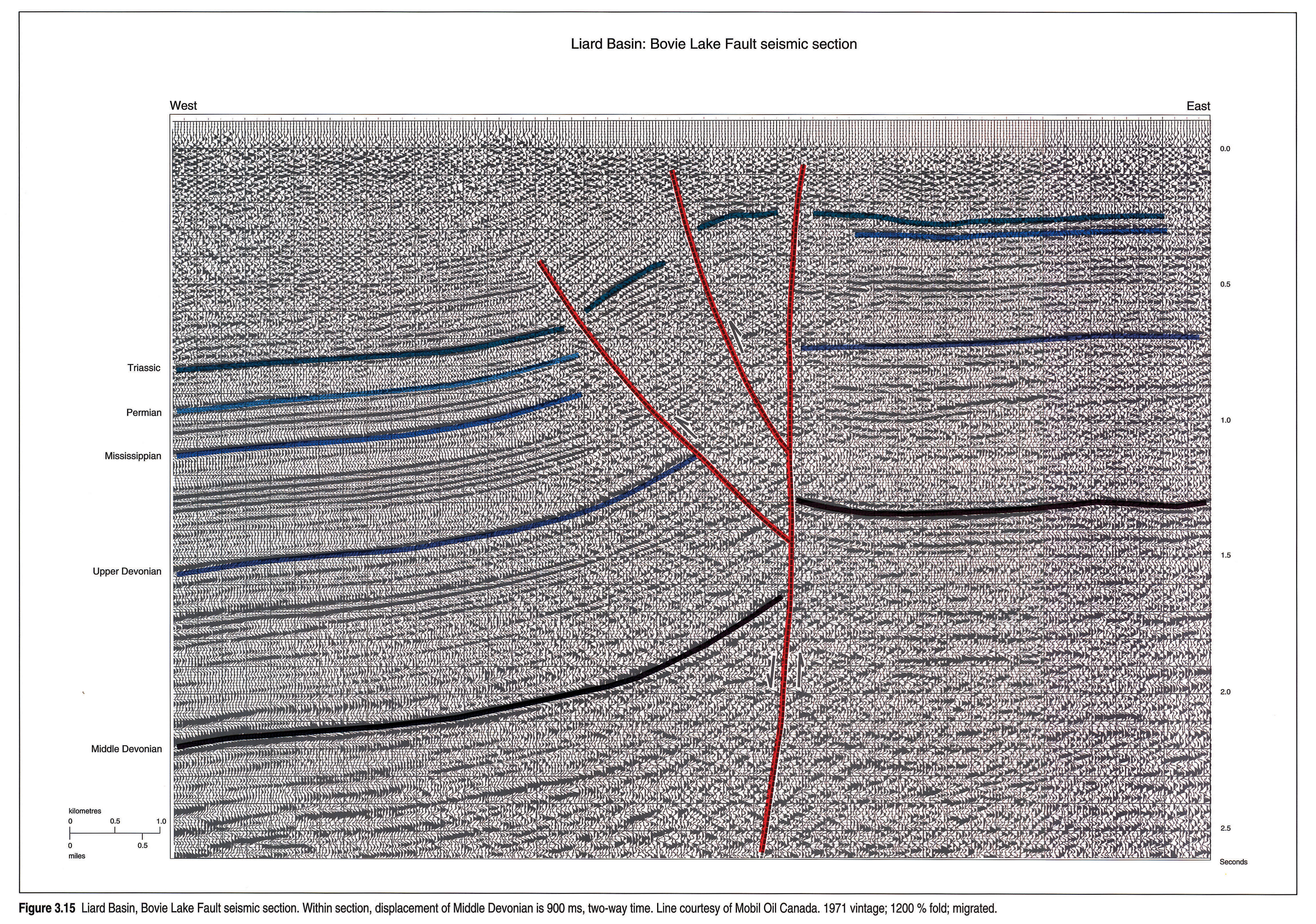
The Liard Basin of northeast British Columbia and the southern Northwest Territories is a striking feature of the WCSB east of the leading edge of the thrust belt (Figs. 3.1, 3.4 left pane, 3.4 right pane, 3.14, 3.15). This 80 km by 200 km unexplored trough is bounded on the east by the Bovie Lake Fault, which is primarily post-Mississippian in age. The fault shows 1200 m of west-side-down vertical displacement of the Middle Devonian, over a horizontal distance of 500 m. The Bovie Lake Fault complex contains normal faults but shows some attributes of lateral and thrust movement. It was re-activated during Cordilleran deformation, which also produced folding within the Liard Basin. The western boundary of the trough is less easily defined, but may be considered to coincide with the eastern edge of the physiographic Rocky Mountain Foothills. The burial history curve (Fig. 3.10a) shows the high deposition rates that have occurred periodically from Mississippian to Tertiary time. A short distance to the east of the Bovie Lake Fault, at about 60°N, 122°W, is the elliptical Celibeta High, which may have been formed early in the Cretaceous (Fig. 3.9).
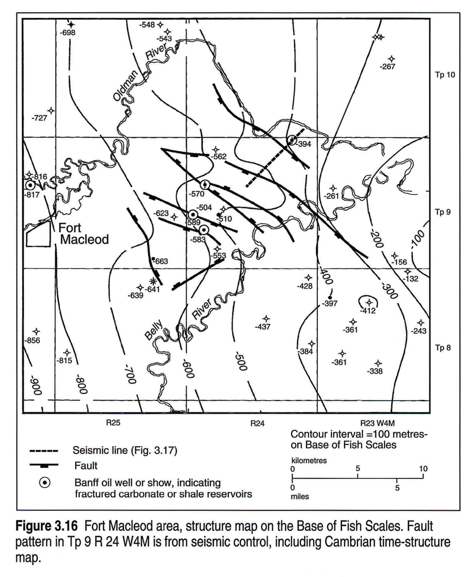
Faults present in deeper strata may be represented by fractures higher in the section; neither are necessarily parallel to the strike of the beds. Near Fort Macleod (Tp 9 R 24 W4M), reflection seismic data indicate that faults with strikes of 120 to 128° clearly affect Devonian and Cambrian strata (Figs. 3.16, 3.17), and are associated with fracturing of Mississippian Banff to mid-Cretaceous Base of Fish Scale zone rocks as determined from borehole data. Bell and Babcock (1986) reported similar borehole breakout azimuths in the area (121-151°). The 262° basin dip direction (Fig. 3.16) is clearly different from the direction of current maximum horizontal stress (211-241° as derived from Bell and Babcock's data).
East of the fold and thrust belt, some normally impermeable Devonian to Cretaceous strata have open fractures containing commercial oil and gas pools. One particularly prolific well was drilled in 1968 near Claresholm (50 km northwest of Fort Macleod) by Dome Petroleum, at 6-6-12-28 W4M, and as of September 1991 had produced 210 264 m3 of oil from perforations into the fractured, oil-rich Cretaceous "Second White Specks" zone. The same zone contains fractured reservoirs in central Alberta at the Pine Creek field (Tp 56 R 19 W5M) where the fractures could be due to a combination of factors such as thrusts, "down to the basin" faults, or differential compaction around underlying reefs. The open fracture system (strike 142°) at Pine Creek is oriented approximately perpendicular to the current direction of maximum horizontal stress (228-229°; Bell and Babcock, 1986). At Edson (Tp 51 R 18 W5M), fractures in Cretaceous shales are associated with minor northeast-directed thrust faulting and the development of passive roof duplexes some 30 km east of the eastern margin of the fold and thrust belt (Skuce et al., 1992).
Williston Basin
The Williston Basin (Figs.3.1, 3.10f, 3.11) is a Late Cambrian to Tertiary intracratonic basin centred in Williams and McKenzie counties, North Dakota, where total sediment thickness reaches 4900 m. The basin is bounded on the west by the Central Montana Uplift and on the east by Precambrian exposures (Fig. 3.11). The southern margin of Williston Basin is defined (using a 2500 m Phanerozoic contour) by the northwest-trending Black Hills Uplift. At the southeastern margin of Williston Basin is the Sioux Uplift (part of the Transcontinental Arch) of South Dakota, which is cored by Precambrian basement.
In simple terms the basin is a saucer-shaped depression with three main structural elements: the northwest-trending Cedar Creek Anticline, and the Nesson Anticline and Bowdoin Dome, all of which have an approximately north-south orientation (Gerhard et al., 1990, and Clement, 1987). On the Cedar Creek Anticline a thin Mississippian section rests on Silurian strata, indicating significant vertical movement. The 25 km wide Bowdoin Dome, with up to 200 m of closure, extends from just north of the Canadian border, southeast for 100 km into Montana. It contains an estimated 13 x 109 of recoverable Upper Cretaceous gas (Rice et al., 1991). Late Cretaceous and Early Tertiary uplift is recorded by erosion across the dome. In Williston Basin other distinct structural elements with 50 to 60 m of relief are oriented along northwest and northeast trends, and contribute significantly to the localization of hydrocarbon reserves. Shifting axes of deposition throughout Paleozoic time are well documented, suggesting intrabasinal basement control as well as influence from the surrounding tectonic elements, especially those to the southwest.
Direct evidence of basement faulting in the Williston Basin comes from both well and seismic data. Kent (1974) and others have suggested that surface lineaments provide indirect indications of a dominant northwest-southeast and a subordinate northeast-southwest fault system. The dominant lineation direction may vary geographically and stratigraphically. Based upon a regional analysis of structural elements, Thomas (1974) concluded that simple shear basement coupling along zones of basement weakness created large rectilinear basement blocks and the present configuration of faults in the Williston Basin. Brown and Brown (1987) proposed that pure shear along a wrench-fault system with both vertical and horizontal displacement created normal faults, grabens, etc., along block boundaries. They explained rotation of basement blocks adjacent to wrench faults by scissor-type faulting in response to adjustment from compressional stress. With the exception of Devonian and early Mississippian strata, Paleozoic strata have a preferential northeast-southwest direction of shear with left lateral movement in response to an estimated azimuth of maximum horizontal stress trending 012°. Within the Mississippian strata, recent work by R.A. Clark (pers. comm.) indicates a common borehole breakout direction of 105°, which correlates with an 015° azimuth of maximum stress, although breakout directions also occur. Extensive studies by Thomas (1974) indicate that in the southern portion of Williston Basin, in Montana and North Dakota, structural features such as the northeast-southwest Brockton-Froid Fault Zone and the Weldon Block are reflected by surface lineaments (Fig. 3.11). Gerhard et al., (1990) proposed that left- lateral shearing of the Precambrian craton along the well-defined northeast-southwest-trending Brockton-Froid Fault Zone and on the Transcontinental margin created the conjugate shear pattern throughout the basin. Secondary elements include the "Divide Re-entrant" (Kissling and Ehrets, 1988), which is on a northeastern extension of the Brockton-Froid Zone that trends perpendicular to the Devonian Winnipegosis shelf margin in North Dakota into a deep, pinnacle-bearing sub-basin in southeastern Saskatchewan.
The Punnichy Arch (Fig. 3.11) trends east-west and defines a structural "lip" in the northern portion of Williston Basin. The arch extends to the southeast to join the Virden-Whitewater Lake erosional high of Manitoba. Movement on the Punnichy Arch may be traced back to Silurian time (Paterson, 1975) with dramatic post-Mississippian erosion that produced relief of up to 300 m. It was re-activated in Early Cretaceous time and also during the Late Albian. Late Albian erosion bevelled the arch and opened up the Late Cretaceous seaway into the Williston Basin (Christopher, 1980, 1984).
Clearly some oil and gas pools in the Williston Basin are associated with fault complexes. Reactivated deep structures are reflected, in part, by erosional or subcrop patterns, and carbonate depositional or diagenetic facies variation. The Minton oil pool in Saskatchewan is an example of a local, fault-bounded basement structure where 40 m of relief at the Ordovician level extends over a 3 by 12 km Precambrian high (Potter and St. Onge, 1991). Near the North Dakota/Saskatchewan border, on a similar high, oil is produced at the Newporte Pool from Cambrian clastics and the weathered basement. Shallow-marine carbonate to evaporite facies boundaries of the Mississippian Mission Canyon Formation (Sherwood Zone) in the Carnduff and Elmore pools of southeastern Saskatchewan are aligned in conjugate patterns with "limbs" 25 to 30 km long, suggesting basement fault controls.
Salt Tectonics
Dissolution of salt and other evaporites has played a major role as an influence on the architecture of the Williston Basin and the northeastern portions of the Alberta Basin (3.4 left pane, 3.4 right pane). Localized salt removal has occurred over several square kilometres in some areas and may be documented using reflection seismic surveys and well data. Removal of Devonian Elk Point salt occurred at both the top and base of the formation (Gendzwill, 1978; Oglesby, 1986) preferentially over Winnipegosis reef mounds. Massive removal of salt from southern Saskatchewan has taken place since mid-Devonian time resulting in some irregularity in later depositional patterns and the development of solution collapse features (Figs. 3.4 left pane, 3.4 right pane, 3.11, 3.18).
In Saskatchewan, the Hummingbird (Smith and Pullen, 1967) and Lake Alma pools lie at the southern end of the Hummingbird Trough (Fig. 3.11) adjacent to the remnant Roncott salt lobe, and provide evidence of several stages of dissolution. Each structural closure has up to 50 m of relief at the Devonian Nisku and Mississippian Ratcliffe horizons and coincides with northwest and northeast basement lineament intersections. Leaching of the salt along basement-controlled faults or fractures continued throughout the Devonian and into Early Mississippian time beneath each pool. Beginning in the Mississippian, salt was dissolved on a much broader scale, with the dissolution front generally advancing north with time. Evidence of dissolution is afforded by the Mississippian Kibbey Formation that is preserved only within the Hummingbird Trough in Saskatchewan. Complete dissolution of the Prairie Evaporite salt in the Hummingbird and Lake Alma pools area in the Late Cretaceous created structural inversion of isolated "lows".
The Innes oil field in Saskatchewan (Tps 7,8 R 10 W2M) provides an example of single stage salt dissolution along two conjugate lineament sets (northeast and northwest) which resulted in the trapping of oil in carbonates of the Mississippian Frobisher Beds resting upon a full section of Prairie Evaporite salt. An initial phase of salt dissolution along the northwest-southeast lineaments during the Mississippian resulted in an elongate "low" infilled with non-reservoir carbonates (Crabtree, 1982) providing the stratigraphic trap. Later (pre-Triassic ?) dissolution along a northwest trend created a deep, "low" axis, approximately 1.5 km in width, updip from the reservoirs, restricting further oil migration.
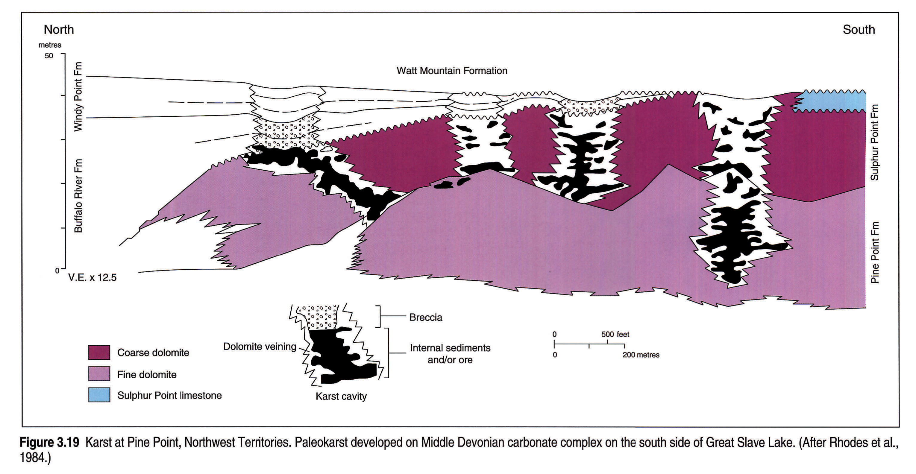
Karst topography is common but only locally documented in Western Canada: one fine example, possibly related to fracturing associated with the underlying linear Great Slave Lake Shear Zone, is in the Pine Point mining district (Fig. 3.18) near the southern shore of the Great Slave Lake (Rhodes et al., 1984), where various types of karst features are developed (Fig. 3.19).
Summary
- The Western Canada Sedimentary Basin consists of the Omineca and Cordilleran Fold and Thrust belts in the west and the loosely defined Alberta and Williston basins to the east.
- Transcurrent faults adjacent to and within the WCSB are the sites of repeated faulting and are visible today as linear topographic features. Examples include the Northern Rocky Mountain Trench and the Hay River Fault. In some areas, faults undoubtedly allowed migration of formation waters and consequent dissolution.
- Precambrian domain boundaries have affected Phanerozoic sedimentary settings, such as at the Dunvegan gas field, where the updip limit of the Mississippian gas pool is defined by the Dunvegan Fault, coincident with the boundary between the Precambrian Ksituan and Chinchaga domains.
- The Cordilleran Fold and Thrust Belt formed during the Jurassic to Eocene collision of the North American plate with terranes to the west. Tectonic loading caused by this deformation depressed the western edge of the North American Craton and made the new foreland basin a dominant feature of the WCSB. Structural style within the fold and thrust belt changes from thrust dominated in the south to fold dominated in the north in response to changes in the lithological character of the deforming basin, specifically in the amount and position of structurally incompetent strata.
- The Bow Island Arch, described by Williams and Burk (1964), is the saddle between the Alberta and Williston basins and may, in part, be a peripheral bulge, generated east of the foreland basin. The arch joins the northern half of the northwest-oriented Sweetgrass Arch of Montana at the Kevin-Sunburst Dome.
- Salt dissolution has profoundly influenced the depositional and structural patterns of post-lower Elk Point (Devonian) sediments in the northern and eastern parts of the WCSB. The position of many oil and gas pools can be attributed to evaporite dissolution on both local and regional scales. In the Williston Basin, dissolution seems related to the intersection of a series of northeast and northwest lineaments.
- The axes of the western Peace River Arch and the Peace River Embayment are almost coincident, and the positive northern rim of the embayment was re-activated in mid-Cretaceous and Tertiary time to form the northern limit of the thicker portion of the crescent-shaped Alberta Basin, itself a product of loading.
- The western depocentres of the Phanerozoic sequences, largely within the fold and thrust belt, are relatively unexplored and potentially contain a large proportion of the undiscovered hydrocarbons of the Western Canada Sedimentary Basin.
Acknowledgements
The authors are deeply indebted to numerous friends and colleagues in the petroleum industry and government, and are especially indebted to their patient spouses. Don Cook, Peter Gretener, and Jim Dixon provided thoughtful and constructive advice as reviewers. Fae Arbour of Mobil Oil Canada is also thanked for facilitating communications between authors. In addition, digital data from Mobil Oil has been extensively used in distilling subsurface information in preparation of this chapter, and Mobil's drafting group have worked very effectively on the non-digital figures. The publications of Ricketts' (1989) and Gerhard et al. (1990) are highly recommended as primers.
References
- Alabi, A.O., Camfield, P.A., and Gough, D.L. 1975. The North American Central Plains conductivity anomaly. Geophysical Journal of the Royal Astronomical Society, v. 43, p. 815-833.
- Barclay, J.E., Krause, F.F., Campbell, R.I., and Utting, J. 1990. Dynamic casting and growth faulting: Dawson Creek Graben Complex, Carboniferous-Permian Peace River Embayment, Western Canada. In: Geology of the Peace River Arch. S.C. O'Connell and J.S. Bell, (eds.). Bulletin of Canadian Petroleum Geology, v. 38A, p. 115-145.
- Barss, D.L. and Montandon, F.A. 1981. Sukunka-Bullmoose gas fields: models for a developing trend in the southern foothills of northeast British Columbia. Bulletin of Canadian Petroleum Geology, v. 29, p. 293-333.
- Beaumont, C. 1981. Foreland Basins. Geophysical Journal of the Royal Astronomical Society, v. 65, p. 291-329.
- Bell, J.S. and Babcock, E.A. 1986. The stress regime of the Western Canada Basin and implications for hydrocarbon production. Bulletin of Canadian Petroleum Geology, v. 34, p. 364-378.
- Bond, G.C. and Kominz, M.A. 1984. Construction of tectonic subsidence curves for the early Paleozoic miogeocline, southern Canadian Rocky Mountains: implications for subsidence mechanisms, age of breakup, and crustal thinning. Geological Society of America, Bulletin, v. 95, p. 155-173.
- Brown, D.L. and Brown, D.L. 1987. Wrench-style deformation and paleostructural influence on sedimentation in and around a cratonic basin. In: Williston Basin - Anatomy of a cratonic oil province. M.W. Longman (ed.). Rocky Mountain Association of Geologists, p. 57-70.
- Burwash, R.A., McGregor, C.R., and Wilson, J. (this volume). Precambrian basement beneath the Western Canada Sedimentary Basin. In: Geological Atlas of the Western Canada Sedimentary Basin. G.D. Mossop and I. Shetsen (comps.). Calgary, Canadian Society of Petroleum Geologists and Alberta Research Council, chpt. 5.
- Camfield, P.A. and Gough, D.I. 1977. A possible plate boundary in North America. Canadian Journal of Earth Science, v. 14, p. 1229-1238.
- Christopher, J.E. 1980. Lower Cretaceous Mannville Group of Saskatchewan - a tectonic overview. In: Lloydminster and Beyond - Geology of Mannville Hydrocarbon Reservoirs. L.S. Beck, J.E. Christopher and D.M. Kent (eds.). Saskatchewan Geological Society Special Publication 5, p. 3-32.
- Christopher, J.E. 1984. Depositional patterns and oilfield trends in the lower Mesozoic of the northern Williston basin. In: Oil and gas in Saskatchewan. J.A. Lorsong and M.A. Wilson (eds.). Saskatchewan Geological Society Special Publication 7, p. 83-102.
- Christopher, J.E. 1987. Depositional patterns and oil field trends in the lower Mesozoic of the northern Canada Williston Basin, Canada. In: Williston Basin, Anatomy of a Cratonic Oil Province. M.W. Longman (ed.). Rocky Mountain Association of Geologists. p. 223-243.
- Clement, J.H. 1987. Cedar Creek: A significant paleotectonic feature of the Williston Basin. In: Williston Basin, Anatomy of a Cratonic Oil Province. M.W. Longman (ed.). Rocky Mountain Association of Geologists. p. 9-43.
- Crabtree, H. 1982. Lithological types, depositional environment and reservoir properties of the Mississippian Frobisher Beds, Innes Field, Southeastern Saskatchewan. In: Fourth Williston Basin Symposium. J.E. Christopher and J. Kaldi (eds.). Special Publication 6, Saskatchewan Geological Society, p. 203-210.
- Dix, G.R. 1990. Stages of platform development in the Upper Devonian (Frasnian) Leduc Formation, Peace River Arch. Alberta. In: Geology of the Peace River Arch. S.C. O'Connell and J.S. Bell (eds.). Bulletin of Canadian Petroleum Geology, v. 38A, p. 115-145.
- Engebretson, D.C., Cox, A., and Gordon, R.G. 1985. Relative motions between oceanic and continental plates in the Pacific Basin. Geological Society of America, Special Paper 206, 59 p.
- Evenchick, C.A. 1991. Geometry, evolution, and tectonic framework of the Skeena fold belt, north-central British Columbia. Tectonics, v. 10. p. 527-546.
- Foley, W.L. 1972. The Sweetgrass Arch. In: Geological Atlas of the Rocky Mountain Region. W.W. Mallory (ed.). Rocky Mountain Association of Geologists. p. 262-264.
- Gabrielse, H. 1985. Major dextral transcurrent displacements along the Northern Rocky Mountain Trench and related lineaments in north-central British Columbia. Geological Society of America, Bulletin, v. 96, p. 1-14.
- Gabrielse, H. and Taylor, G.C. 1982. Geological maps and cross-sections of the Cordillera from near Fort Nelson, British Columbia to Gravina Island, southeastern Alaska. Geological Survey of Canada, Open File Report 864.
- Gendzwill, D.J. 1978. Winnipegosis mounds and Prairie Evaporite Formation of Saskatchewan; seismic study. American Association of Petroleum Geologists, Bulletin, v. 62, p. 73-68.
- Gerhard, L.C., Anderson, S.B. and Fischer, D.W. 1990. Petroleum Geology of the Williston Basin. In: Interior Cratonic Basins. M.W. Leighton, D.R. Kolata, D.F. Oltz, and J.J. Eidel, (eds.). American Association of Petroleum Geologists, Memoir 51. p. 507-559.
- Gordy, P.L. and Frey, F.R. 1975. Structural cross section enclosure. In: Structural Geology of the Foothills between Savanna Creek and Panther River, S.W. Alberta, Canada. H.J. Evers and J.E. Thorpe (eds.). Guidebook. Canadian Society of Petroleum Geologists and Canadian Society of Exploration Geophysicists.
- Hein, F.J., and McMechan, M.E. (this volume). Proterozoic and Lower Cambrian strata of the Western Canada Sedimentary Basin. In: Geological Atlas of the Western Canada Sedimentary Basin. G.D. Mossop and I. Shetsen (comps.). Calgary, Canadian Society of Petroleum Geologists and Alberta Research Council, chpt. 6.
- Henderson, C.M. 1989. The Lower Absaroka Sequence: Upper Carboniferous and Permian. In: Western Canada Sedimentary Basin, A Case History. B.D. Ricketts (ed.). Canadian Society of Petroleum Geologists. p. 203-231.
- Hoffman, P.F. 1987. Continental transform tectonics: Great Slave Lake Shear Zone (ca. 1.9 Ga), northwest Canada. Geology, v. 15, p. 785-788.
- Holter, M.E. 1969. The Middle Devonian Prairie Evaporite of Saskatchewan. Saskatchewan Department of Mineral Resources. Report 123. 134 p.
- Issler, D.R., Beaumont, C., Willet, S.D., Donelick, R.A., Mooers, J., and Grist, A. 1990. Preliminary evidence from apatite fission-track data concerning the thermal history of the Peace River Arch region, Western Canada Sedimentary Basin. In: Geology of the Peace River Arch. S.C. O'Connell and J.S. Bell (eds.). Bulletin of Canadian Petroleum Geology, v. 38A, p. 250-269.
- Jensen, F.S. 1972. In: Geological Atlas of the Rocky Mountain Region. W.W. Mallory (ed.). Rocky Mountain Association of Geologists, p. 56.
- Jones, P.B. 1982. Oil and gas beneath east-dipping underthrust faults in the Alberta Foothills. In: Studies of the Cordilleran Thrust Belt. R.B. Powers (ed.). Rocky Mountain Association of Geologists, p. 61-74.
- Kalkreuth, W. and McMechan, M.E. 1984. Regional pattern of thermal maturation as determined from coal-rank studies, Rocky Mountain Foothills and Front Ranges north of Grande Cache, Alberta - implications for petroleum exploration. Bulletin of Canadian Petroleum Geology, v. 32, p. 249-271.
- Kalkreuth, W. and McMechan, M.E. 1988. Burial history and thermal maturity, Rocky Mountain Front Ranges, Foothills and Foreland, east-central British Columbia and adjacent Alberta, Canada. American Association of Petroleum Geologists, Bulletin, v. 72, p. 1395-1410.
- Kent, D.M. 1974. Relationship between hydrocarbon accumulations and basement structural elements in the northern Williston Basin. In: Fuels: a geological appraisal. G.R. Parslow, (ed.). Saskatchewan Geological Society Special Publication 2.
- Kent, D.M. 1987. Paleotectonic controls on sedimentation in the Northern Williston Basin, Saskatchewan. In: Williston Basin: Anatomy of a Cratonic Oil Province. M.W. Longman (ed.). Rocky Mountain Association of Geologists.
- Kent, D.M. and Christopher, J.E. (this volume). Geological history of the Williston Basin and Sweetgrass Arch. In: Geological Atlas of the Western Canada Sedimentary Basin. G.D. Mossop and I. Shetsen (comps.). Calgary, Canadian Society of Petroleum Geologists and Alberta Research Council, chpt. 27.
- Kissling, D.L. and Ehrets, J.R. 1988. Devonian reservoirs, southeastern Saskatchewan - an exploration evaluation. Unpublished study conducted by Jackalope Geological Ltd.
- Leckie D.A., Staniland, M.R., and Hayes, B.J. 1990. Regional maps of the Albian Peace River and lower Shaftesbury formations on the Peace River Arch, northwestern Alberta and northeastern British Columbia. In: Geology of the Peace River Arch. S.C. O'Connell, and J.S. Bell, (eds.). Bulletin of Canadian Petroleum Geology, v. 38A, p. 176-189.
- Majorowicz, J.A., Jones, F.W., and Osadetz, K.G. 1988. Heat flow environment of the electric conductivity anomalies in the Williston Basin, and occurrences of hydrocarbons. Bulletin of Canadian Petroleum Geology, v. 36, p. 88-90.
- Marvin, R.F., Hearn, B.C., Mehnert H.H., Naeser, C.W., Zartman, R.E., and Lindsey, D.A. 1980. Late Cretaceous-Paleocene igneous activity in north-central Montana. Isochron/West, no. 29, p. 5-25.
- McMechan, R.D. 1981. Stratigraphy, sedimentology, structure and tectonic implications of the Oligocene Kishenehn Formation, Flathead Valley graben, southeastern British Columbia. Unpublished Ph.D. thesis, Queen's University, Kingston, Ontario, v. 1 and 2, 327 p.
- McMechan, M.E. 1990. Upper Proterozoic to Middle Cambrian history of the Peace River Arch; evidence from the Rocky Mountains. In: Geology of the Peace River Arch. S.C. O'Connell, and J.S. Bell, (eds.). Bulletin of Canadian Petroleum Geology, v. 38A, p. 36-44.
- McMechan, M.E. and Thompson, R.I. 1989. Structural style and history of the Rocky Mountain Fold and Thrust Belt. In: Western Canada Sedimentary Basin, A Case History. B.D. Ricketts (ed.). Canadian Society of Petroleum Geologists. p. 47-76.
- McMechan, M.E. and Thompson, R.I. (in press). The Cordilleran Fold and Thrust Belt south of 66° N and its influence on the Western Interior Basin. In: Evolution of the Western Interior Basin. W.G.E. Caldwell and E.G. Kaufman (eds). Geological Association of Canada, Special Paper 39.
- Meijer Drees, N.C. (this volume). Devonian Elk Point Group of the Western Canada Sedimentary Basin. In: Geological Atlas of the Western Canada Sedimentary Basin. G.D. Mossop and I. Shetsen (comps.). Calgary, Canadian Society of Petroleum Geologists and Alberta Research Council, chpt. 10.
- Milne, W.G., Rogers, G.C., Riddihough R.P., McMechan, G.A., and Hyndman, R.D. 1978. Seismicity of Western Canada. Canadian Journal of Earth Sciences, v. 15, p. 1170-1193.
- Monger, J.W.H. 1989. Overview of Cordilleran geology. In: Western Canada Sedimentary Basin, A Case History. B.D.Ricketts (ed.). Canadian Society of Petroleum Geologists. p. 9-45.
- Morrow, D.W., Potter, J., Richards, B., and Goodarzi, F. 1993. Thermal maturation of organic material in the Liard Basin, northern Canada. Bulletin of Canadian Petroleum Geology, v. 41, p. 17-31.
- Norford, B.S. 1990. Ordovician and Silurian stratigraphy, paleogeography and depositional history in the Peace River Arch area, Alberta and British Columbia. In: Geology of the Peace River Arch. S.C. O'Connell and J.S. Bell (eds.). Bulletin of Canadian Petroleum Geology, v. 38A, p. 45-54.
- Norford, B.S., Haidl, F.M., Bezys, R.K., Cecile, M.P., McCabe, H.R., and Paterson, D.F. (this volume). Middle Ordovician to Lower Devonian Strata of the Western Canada Sedimentary Basin. In: Geological Atlas of the Western Canada Sedimentary Basin. G.D. Mossop and I. Shetsen (comps.). Calgary, Canadian Society of Petroleum Geologists and Alberta Research Council, chpt. 9.
- Nurkowski, J.R. 1984. Coal quality, coal rank variation and its relation to reconstructed overburden, Upper Cretaceous and Tertiary plains coals, Alberta, Canada. American Association of Petroleum Geologists, Bulletin, v. 68, p. 285-295.
- Nurkowski, J.R. 1985. Coal quality and rank variations within Upper Cretaceous and Tertiary sediments, Alberta Plains region. Alberta Research Council, Earth Sciences Report 85-1, 39 p.
- O'Connell, S.C. and Bell, J.S. (eds.). 1990. Geology of the Peace River Arch. Bulletin of Canadian Petroleum Geology, v. 38A.
- O'Connell, S.C. (this volume). Geological history of the Peace River Arch. In: Geological Atlas of the Western Canada Sedimentary Basin. G.D. Mossop and I. Shetsen (comps.). Calgary, Canadian Society of Petroleum Geologists and Alberta Research Council, chpt. 28.
- Oglesby, C.A. 1986. Depositional and dissolutional processes and their resulting thinning patterns within the Middle Devonian Prairie Formation, Williston Basin, North Dakota and Montana. American Association of Petroleum Geologists, Bulletin, v. 72, p. 878.
- Osadetz, K.G., Pearson, D.E., and Stasiuk, L.D. 1990. Paleogeothermal gradients and changes in the geothermal gradient of the Alberta Plains. In: Current Research, Part D, Geological Survey of Canada, Paper 90-1D, p. 165-178.
- Paterson, D.F. 1975. Computer plotted isopach and structure maps of the lower Paleozoic formations in Saskatchewan. Saskatchewan Department of Mineral Resources, Report 201.
- Porter, J.W. and Fuller, J.G.C.M. 1959. Lower Paleozoic rocks of the northern Williston Basin area. American Association of Petroleum Geologists, Bulletin, v. 43, p. 124-189.
- Potter, D.E.G. and St. Onge, A. 1991. Minton Pool, south-central Saskatchewan: A model for basement-induced structural and stratigraphic relationships. In: Sixth International Williston Basin Symposium. J.E. Christopher, and F. Haidl (eds.). Saskatchewan Geological Society Special Publication 11.
- Price, R.A. 1973. Large-scale gravitational flow of supracrustal rocks, southern Canadian Rockies. In: Gravity and Tectonics. K.A. De Jong and R. Scholten (eds.). Wiley and Sons, New York, p. 491-502.
- Price, R.A. (this volume). Cordilleran tectonics and the evolution of the Western Canada Sedimentary Basin. In: Geological Atlas of the Western Canada Sedimentary Basin. G.D. Mossop and I. Shetsen (comps.). Calgary, Canadian Society of Petroleum Geologists and Alberta Research Council, chpt. 2.
- Price, R.A. and Carmichael, D.M. 1986. Geometric test for Late Cretaceous-Paleogene intracontinental transform faulting in the Canadian Cordillera. Geology, v. 14, p. 468-471.
- Price, R.A. and Fermor, P.R. 1984. Structure section of the Cordilleran Foreland Thrust and Fold Belt west of Calgary. Geological Survey of Canada Map 1501A.
- Rhodes, D., Lantos, E.A., Lantos, J.A., Webb, R.J., and Owens, D.C. 1984. Pine Point orebodies and their relationship to the stratigraphy, structure, dolomitization, and karstification of the Middle Devonian barrier complex. Economic Geology, v. 79, p. 991-1055.
- Rice, D.D., Nydegger, G.L., and Brown, C.A. 1991. Bowdoin Field, U.S.A. In: Structural Traps III, Treatise of Petroleum Geology, Atlas of Oil and Gas Fields. American Association of Petroleum Geologists, p. 337-355.
- Richards, B.C. 1989. Upper Kaskaskia Sequence - uppermost Devonian and Lower Carboniferous. In: Western Canada Sedimentary Basin, A Case History. B.D. Ricketts (ed.). Canadian Society of Petroleum Geologists, p. 165-201.
- Ross, G. 1989. Crystalline basement: the foundation of Western Canada Sedimentary Basin. In: Western Canada Sedimentary Basin, A Case History. B.D.Ricketts (ed.). Canadian Society of Petroleum Geologists, p. 33-45.
- Ross, G.M., Broome, J., and Miles, W. (this volume). Potential fields and basement structure - Western Canada Sedimentary Basin. In: Geological Atlas of the Western Canada Sedimentary Basin. G.D. Mossop and I. Shetsen (comps.). Calgary, Canadian Society of Petroleum Geologists and Alberta Research Council, chpt. 4.
- Sawatzky, H.B. 1975. Astroblemes in the Williston Basin. In: Fuels: A Geological Appraisal. G.R. Parslow (ed.). Saskatchewan Geological Society, Special Publication no. 2. p. 95-117.
- Skuce, A.G., Goody, N.P., and Maloney, J. 1992. Passive-roof duplexes under the Rocky Mountain Foreland Basin. American Association of Petroleum Geologists, Bulletin, v. 76, p. 67-80.
- Sloss, L.L. 1963. Sequences in the cratonic interior of North America. Geological Society of America, Bulletin, v. 74, p. 93-114.
- Sloss, L.L. 1988. Forty years of sequence stratigraphy. Geological Society of America, v. 100, p. 1661-1665.
- Smith, D.G. and Pullen, J.R. 1967. Hummingbird structure of southeast Saskatchewan. Bulletin of Canadian Petroleum Geology, v. 15, p. 468-482.
- Struik, L.C. 1987. The ancient western North American margin: an alpine rift model for the east-central Canadian Cordillera. Geological Survey of Canada, Paper 87-15, 19 p.
- Thomas, G.E. 1974. Lineament block tectonics: Williston-Blood Creek basins. American Association of Petroleum Geologists, Bulletin, v. 58, p. 1305-1322.
- Wheeler, J.O. and McFeely, P. 1987. Tectonic assemblage map of the Canadian Cordillera and adjacent parts of the United States of America, 1:2,000,000 scale. Geological Survey of Canada, Open File Report 1565.
- Williams, G.D. and Burk, C.F. 1964. Upper Cretaceous. In: A Geological History of Western Canada. R.G. McGrossan, and R.P. Glaister, (eds.). Alberta Society of Petroleum Geologists. p. 169-189.
- Williams, D.Y. and Dyer, W.S. 1930. Geology of southern Alberta and southwestern Saskatchewan. Geological Survey of Canada, Memoir 163.
- Wright, G.N. (ed.) 1984. The Western Canada Sedimentary Basin, a series of geological sections illustrating basin stratigraphy and structure. Canadian Society of Petroleum Geologists and the Geological Association of Canada.
- Wu, P. 1991. Flexure of lithosphere beneath the Alberta Foreland Basin: evidence of an eastward stiffening continental lithosphere. Geophysical Research Letters, v. 18, no. 3, p. 451-454