Chapter 31 - Petroleum Generation and Migration in the Western Canada Sedimentary Basin |
|
| Chapter Sections | Download |
|
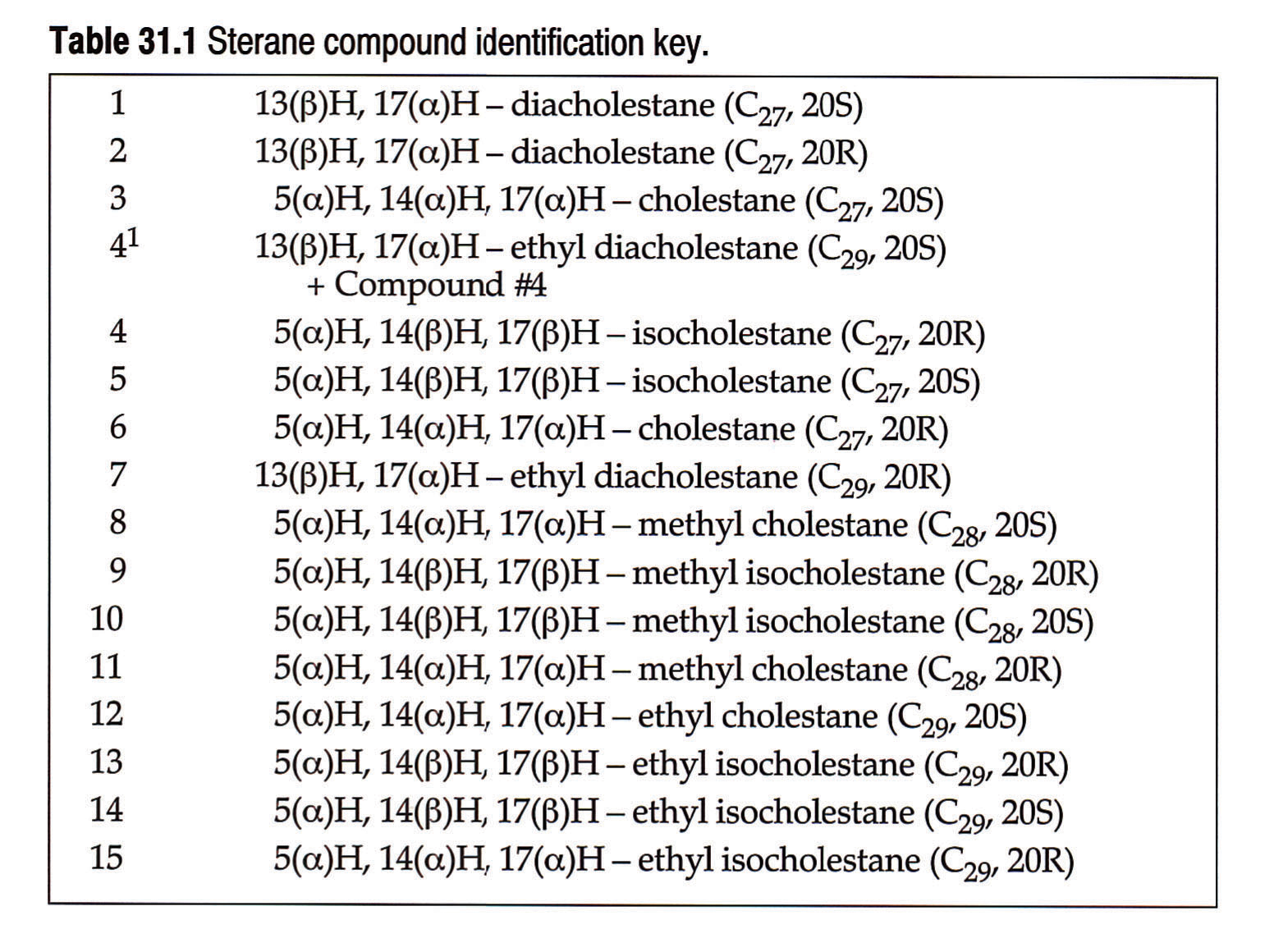
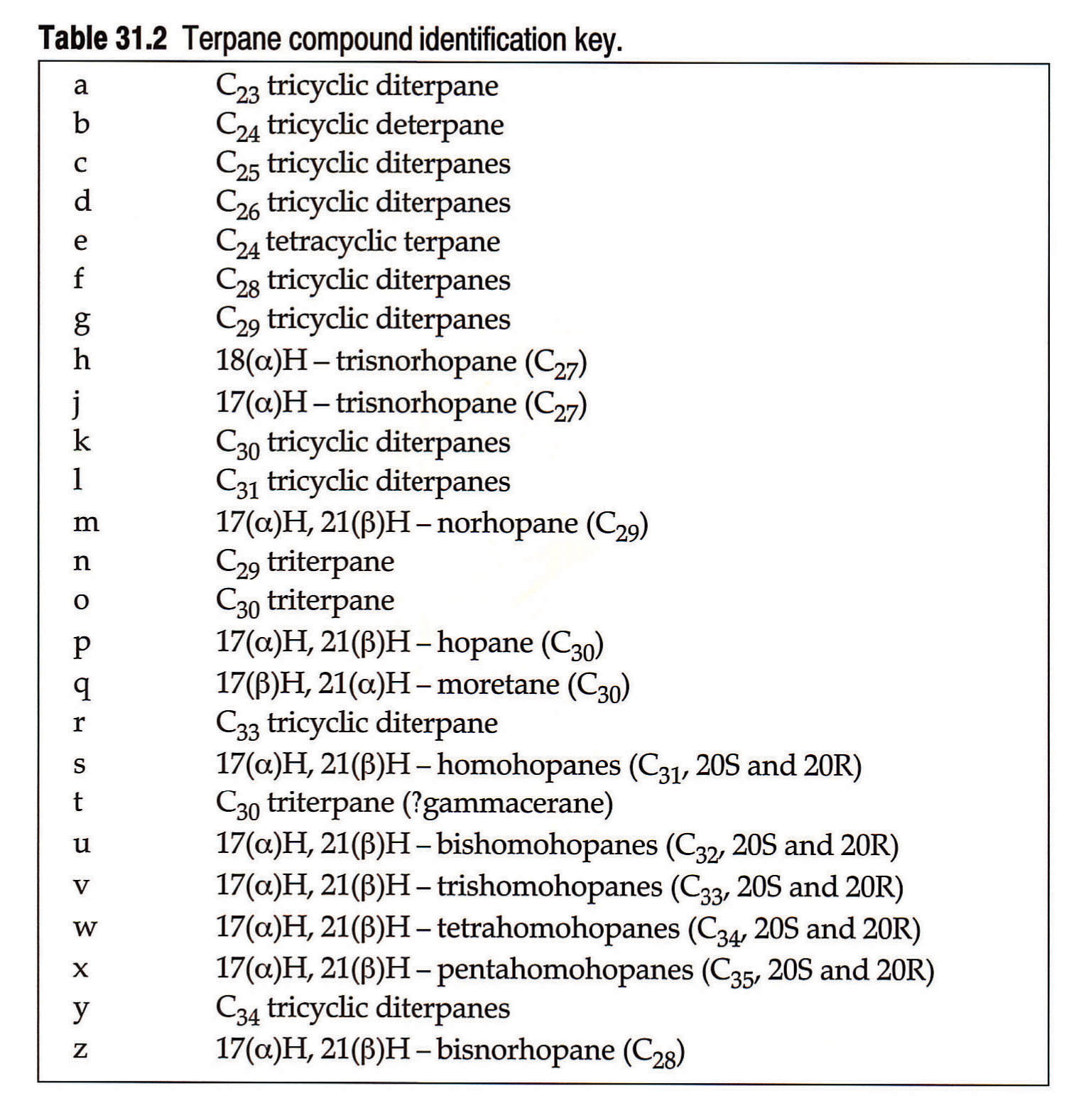
Tables: Table 31.1 Sterane compound identification key. Table 31.2 Terpane compound identification key.
|
Authors: S. Creaney - Imperial Oil Resoures Ltd., Calgary J. Allan - Imperial Oil Resources Ltd., Calgary K.S. Cole - Imperial Oil Resources Ltd., Calgary M.G. Fowler - Geological Survey of Canada, Calgary P.W. Brooks - Geological Survey of Canada, Calgary K.G. Osadetz - Geological Survey of Canada, Calgary R.W. Macqueen - Geological Survey of Canada, Calgary L.R. Snowdon - Geological Survey of Canada, Calgary CL. Riediger - The University of Calgary, Calgary
Introduction
The role of this theme chapter is to familiarize the reader with the current state of knowledge concerning the origin and history of petroleum within the Western Canada Sedimentary Basin. The previous atlas (McCrossan and Glaister, 1964) provided considerable stratigraphic information plus a chapter on formation fluids (Hitchon, 1964). The information contained in the 1964 atlas predated the development of tools that permit the convincing correlation of petroleum fluids to their source rocks and to their thermal regime of origin. In addition, the processes of petroleum alteration via biodegradation and water washing were poorly understood, leaving the origin of Western Canada's oil sands and heavy oil deposits unresolved.
The present contribution provides a summary of the petroleum systems that operate in the Western Canada Sedimentary Basin. It does so from the point of view of petroleum exploration as opposed to a detailed analytical geochemical approach. Thus, summary maps are presented with only sufficient data to illustrate oil-oil and oil-source correlations rather than exhaustive data compilations. These data are located elsewhere in the public literature and are referenced as appropriate.
The authors represent two groups working extensively on petroleum geochemistry in the Western Canada Sedimentary Basin and, as with all science, divergences of opinion do exist. Where these are manifest both arguments are presented. The information herein is drawn from a number of sources, principally Creaney and Allan (1990, 1992), Allan and Creaney (1991), Brooks et al. (1988, 1989, 1990), Osadetz and Snowdon (in press), Osadetz et al. (1991), Riediger et al. (1990 a,b), Riediger (1991) and Deroo et al. (1977).
When analyzing the petroleum systems of any sedimentary basin, especially one whose exploration history is as long as that of the Western Canada Sedimentary Basin, one objective is to understand the geographic and geological distributions of petroleum. Figure 31.1 comprises a pair of histograms showing original in-place conventional oil reserves versus reservoir age for the Western Canada Sedimentary Basin (B.C., Alberta, Saskatchewan). It is this distribution that this chapter seeks to explain. The current state of knowledge of thermal gas-source rock correlation is too poor to make discussion of the geological distribution of gas reserves meaningful in the petroleum system context. Gas occurrence and origin are discussed for certain specific examples wherever the data make this possible.
Formation water geochemistry is not discussed in any detail in this chapter and the reader is referred to Hitchon (1964), and Hitchon et al. (1990) for detailed discussions and more reference material on this topic.
Petroleum Systems
To facilitate discussion of petroleum in the Western Canada Sedimentary Basin, a petroleum system terminology is used. According to Magoon (1988), "a petroleum system includes all those geologic elements and processes that are essential for an oil and gas deposit to exist." These basic elements include source rock, maturation, migration path, reservoir rock, trap, and seal. Demaison and Huizinga (1991) further refined this concept with their introduction of a genetic classification of petroleum systems. Within this classification the Western Canada Sedimentary Basin is a supercharged, laterally drained, low impedance basin. In actual fact, the basin comprises a number of discrete petroleum systems linked to a number of source rocks. In this chapter each petroleum system is named after the source rock, where possible, and the limits of the system are defined by the extent of migration of petroleum from that discrete source. We also refer to certain systems as being "closed" or "open" systems, which we define as follows. A closed petroleum system is one in which petroleum generated from a particular source generally does not migrate out of rocks of the same age. An example of a closed petroleum system in the basin would be the Middle Devonian reefs of northwestern Alberta, which are sourced exclusively from Middle Devonian source rocks. An example of an open petroleum system would be the Middle Devonian of the Williston Basin (U.S. portion mainly), where Winnipegosis (Middle Devonian) sourced oils are found in Silurian to Mississippian reservoirs. In this case regional seals have been fractured tectonically or via salt collapse structures, thereby "opening" the Middle Devonian system. The terms "open" and "closed" are somewhat imprecise but do allow qualitative comparisons of systems, in terms of their migration style.
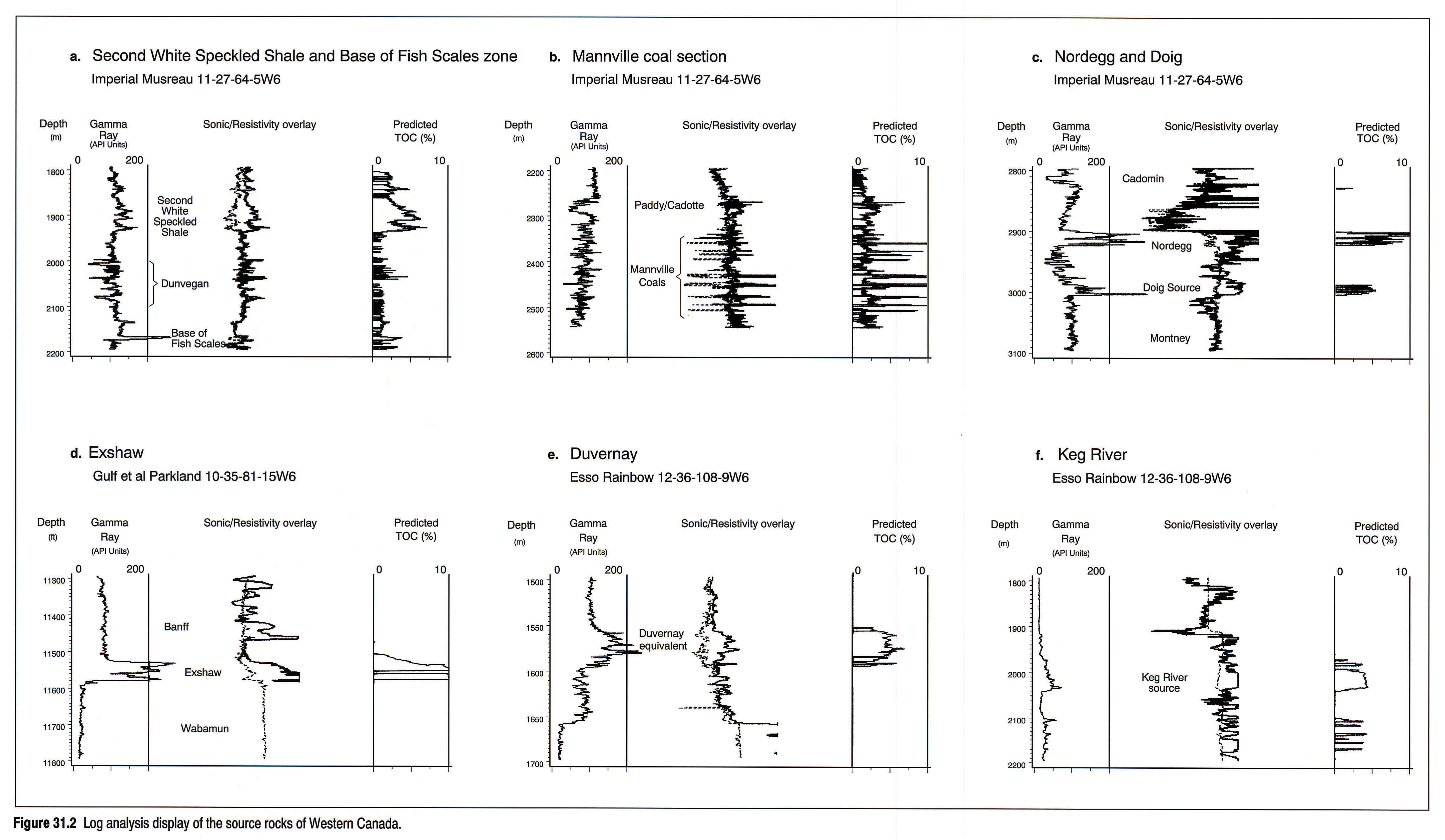
Figure 31.2 provides an overview of the source rocks in the Western Canada Sedimentary Basin using the log analysis technique of Passey et al. (1989, 1990). A total of eight marine sources are shown (the Ordovician of the Williston Basin is not shown) and the gas-prone Mannville section is also illustrated.
Definitions
Although organic geochemical and petrographic terminology is kept to a minimum, certain terms may need explanation. Vitrinite is a coal maceral that is used in the determination of coal rank and organic maturity levels by means of measuring its reflectivity (VR). Kerogen describes the indigenous organic matter of sedimentary rocks, insoluble in common organic solvents, studied using both organic petrological and chemical techniques. Three types of kerogen are defined by atomic hydrogen to carbon (H/C) ratio as Type I (H/C less than 1.4), Type II (H/C 1.2-1.4) and Type III (H/C less than1.0). Rock-Eval pyrolysis is a means of rapidly estimating these values on either kerogen or whole rock through the Hydrogen Index (mg hydrocarbon/g organic carbon). A separate module on this instrument also provides a measure of the total organic carbon content (TOC), the parameter usually used to indicate source rock richness.Tmax, the Rock-Eval temperature (°C) at the point of maximum hydrocarbon evolution during pyrolysis, is a measure of the thermal maturity of the sample, with the oil window typically falling in the range of 430°C to 455°C. Alkanes are saturated (single bonds between the carbon atoms) hydrocarbons. Normal alkanes or paraffins have the carbons arranged in long chains, while the terms cyclic and branched alkanes describe the arrangement of carbon atoms in rings or with side chains. Biomarkers are compounds (commonly polycyclic alkanes) that have structures similar to biological molecules and are commonly diagnostic of the total organic material in a rock. Biomarkers can be used to draw inferences about the depositional environment and to track such processes as maturation, migration, and biodegradation. Typical biomarkers include sterane compounds derived from steroids in living organic matter, and the isoprenoid alkanes, pristane and phytane, derived, at least in part, from chlorophyll. The term odd/even (or even/odd) predominance refers to normal alkane chain lengths and describes the characteristics of paraffin compounds in gas chromatograms. The ratio of odd/even chain lengths can be used to estimate thermal maturity and to draw inferences about the source rock character. All of these terms are discussed in detail in organic geochemical treatises such as that by Tissot and Welte (1984). Many are reviewed briefly in Macauley et al. (1985).
The Ordovician Petroleum System
Source Rocks and Maturity
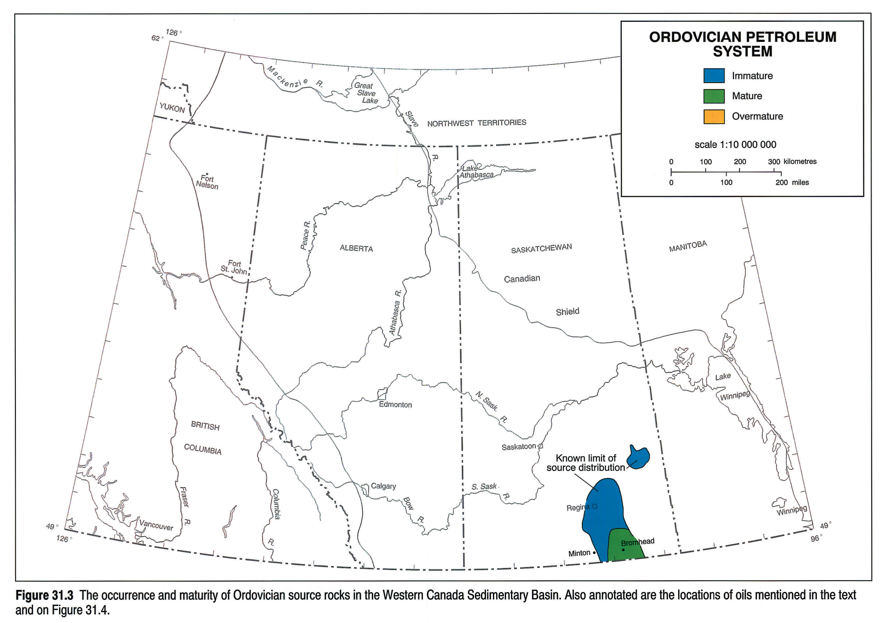
Ordovician source rocks are known only from the Williston Basin portion of the Western Canada Sedimentary Basin (Osadetz and Snowdon, in press; Osadetz and Haidl, 1989; Osadetz et al., 1989). Sources are described as being generally thin (centimetre to decimetre scale) and laterally discontinuous. They are collectively referred to as "kukersites" and occur sporadically in the Ordovician of Saskatchewan, in the Gunn Member of the Stony Mountain Formation (thin and of unknown lateral extent); Lake Alma Member, Herald Formation; Yeoman Formation; and in the Icebox Member of the Winnipeg Formation (see Norford et al., this volume, Chapter 9). The organic carbon contents of these source rock laminae range up to 35 percent (wt) where pure, with hydrogen indices (HI) commonly > 800 (Macauley et al., 1990). The organic matter is characteristically Type I and composed dominantly of Gloeocapsomorpha prisca (Stasiuk and Osadetz, 1990). Figure 31.3 shows the known occurrence of Ordovician source rocks and their present-day maturity. The definition of mature versus immature zones in Type I kerogen source rocks is somewhat difficult because the kinetic energy spectrum of Type I kerogen is very narrow, resulting in delays of the onset of maturity to around VR = 0.67 percent and oil generation then occurs over a relatively narrow range from 0.67 to 1.10 percent VR (Espitalié, 1986). Using transformation ratios, the oil window can be defined as occurring below present depths of 2950 m in selected parts of southeastern Saskatchewan.
Oil Chemistry and Migration
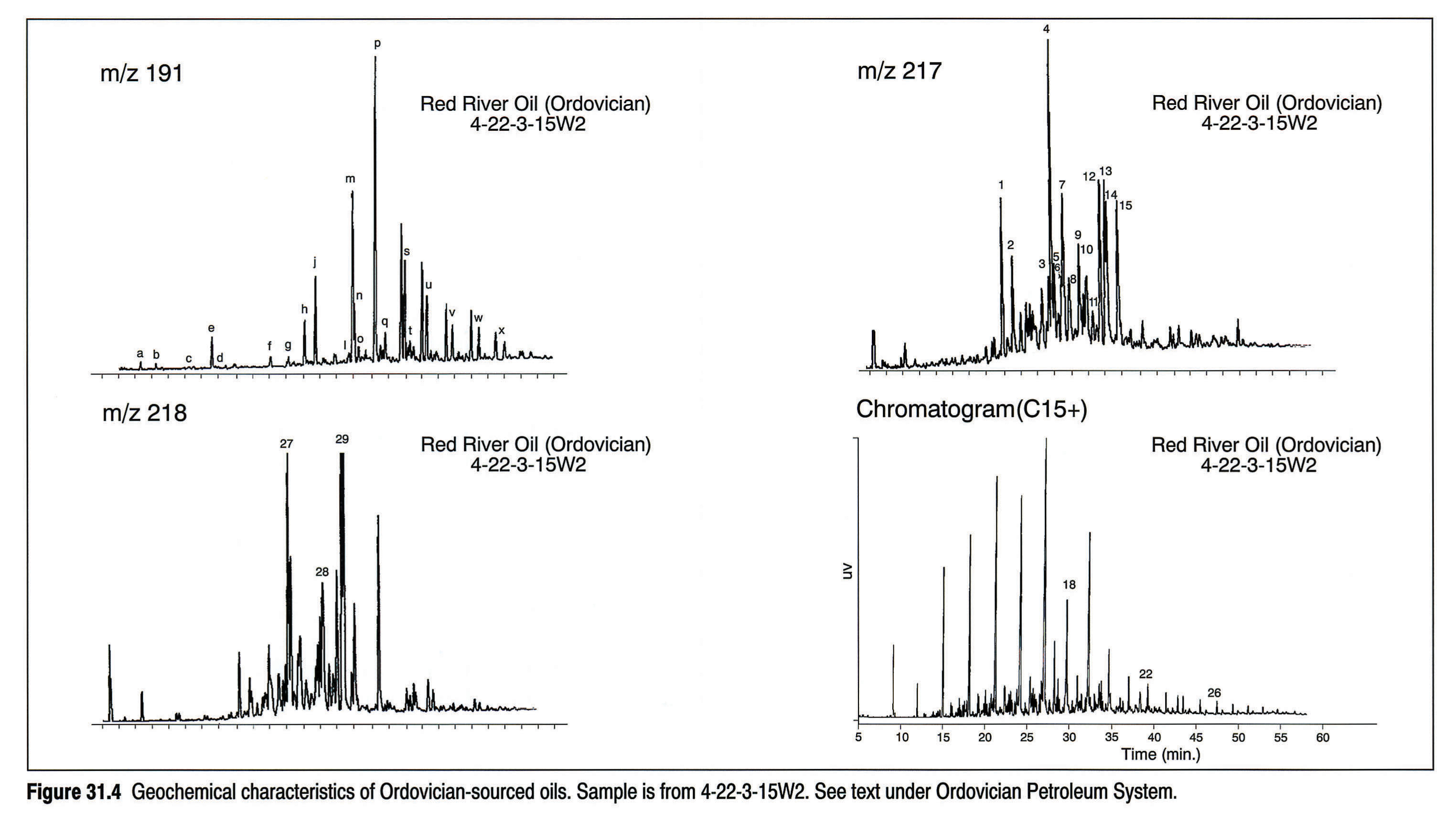
Ordovician-sourced oils commonly have a characteristic whole-oil chromatogram (Fig. 31.4) that shows reduced amounts of paraffins above C20, a near absence of isoprenoid paraffins and a pronounced odd/even n-paraffin predominance in the C13 - C19 range. The oils are characteristically high quality and low in sulphur content. Sterane (217 and 218 m/z) and terpane (191 m/z) biomarkers are also shown in Figure 31.4 for completeness. All the oils and stains hosted by Ordovician rocks and examined to date (Osadetz et al., 1991) are sourced from Ordovician rocks. In addition, a single occurrence of Ordovician-sourced oil exists outside of Ordovician reservoirs in the Williston Basin (Canada); this occurrence is within the Winnipegosis at Minton, Saskatchewan (Osadetz et al., 1991; Potter and St. Onge, 1991). Thus, the Ordovician is largely a closed petroleum system in Canada, with migration having taken place over relatively short lateral distances and vertically confined by extensive anhydrite seals. Winnipegosis-hosted oil at Minton has migrated vertically via locally developed fractures from the Ordovician into the Middle Devonian Winnipegosis shelf deposits.
To the south, in the U.S. portion of the Williston Basin, faulting and folding have opened the system and connected Ordovician sources to multiple reservoirs (Dow, 1974; Williams, 1974; Zumberge, 1983; Fowler et al., 1986; Leenheer and Zumberge, 1987; Osadetz et al., 1990).
The Keg River/Brightholme Petroleum System
Source Rocks and Maturity
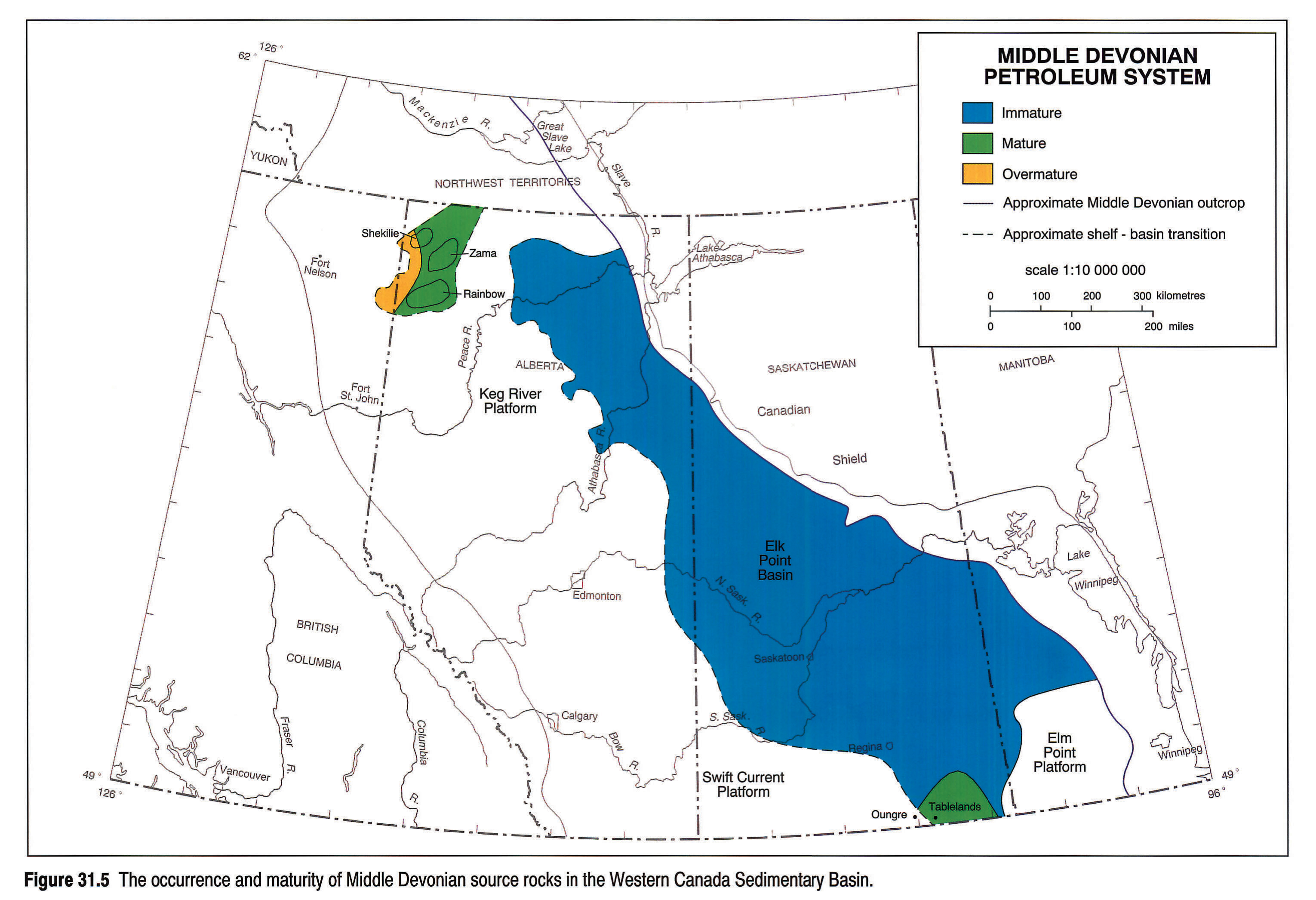
Middle Devonian source rocks have been discussed by several authors (Powell, 1984; Creaney and Allan, 1990; Allan and - Creaney, 1991; Osadetz et al.,1991; Osadetz and Snowdon, in press) and shown to be confined to the Elk Point Basin. Figure 31.5 shows the approximate extent of this basinal source facies with full thermal maturity attained only in southeastern Saskatchewan and northwestern Alberta. In southeastern Saskatchewan, the source facies is a basinal, marine laminite that was deposited coevally with adjacent Winnipegosis reefs. This unit, informally known as the Brightholme member, has organic carbon values up to 46 percent and hydrogen indices up to 800 ±, although more typically a Type II HI of ~615 is observed where immature. The basinal laminites are known to reach 15 m in thickness in Manitoba (Rosenthal, 1987) and to be between 0.6 and 1.0 m thick in Saskatchewan.
In northeastern Alberta, the source facies has been sampled in cores and found to contain up to 15 percent organic carbon with hydrogen indices up to about 440. The sediments are immature in this part of the basin. In the mature, producing areas of Rainbow and Zama, the source has been recognized on logs but not sampled in core (see Fig. 31.2f).
Oil Chemistry and Migration
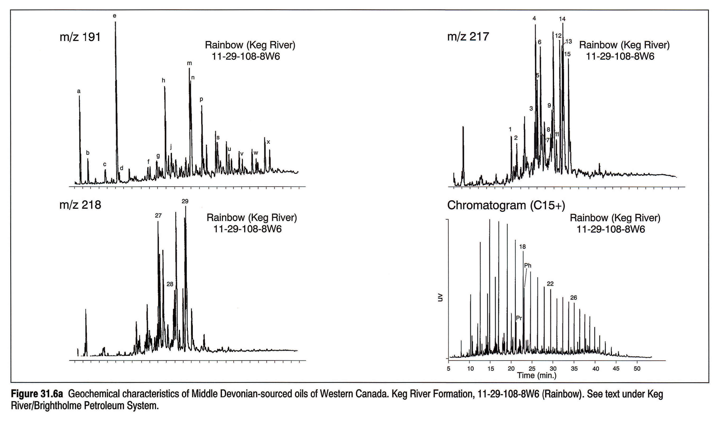
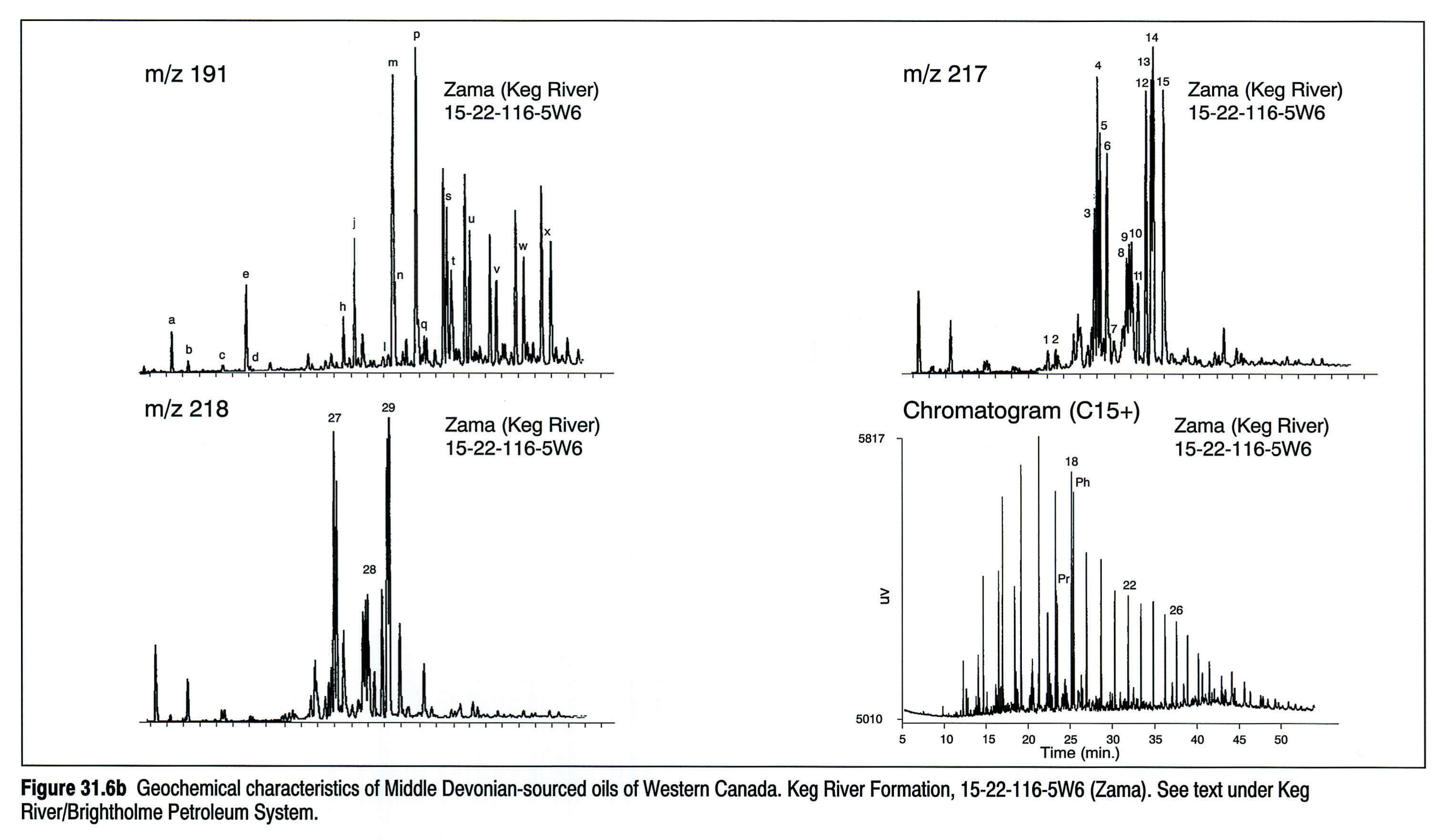
Several workers have described oil correlations from the Middle Devonian of Western Canada (Clark and Philp, 1989; Allan and Creaney, 1991; Osadetz et al., 1991). At least two oil families are recognized in the Keg River and Muskeg pools in the Rainbow and Zama sub-basins. Oils from the Zama, Shekilie and Virgo pools can be distinguished easily from most Rainbow sub-basin Keg River oils by their triterpane distributions. The latter are unusual in being dominated by 8,14 secohopanes. Possible mixing between the two sources appears to have occurred in Muskeg and some Keg River reservoirs in the Rainbow sub-basin (M.G. Fowler, unpub. data). Despite its proximity to the Zama sub-basin, oil of the Amber area more closely resembles that found in most of the Rainbow sub-basin Keg River reservoirs. The geochemical characteristics of the two principal oil families (Figs. 31.6a, 31.6b) suggest extreme environmental conditions across the floor of the sub-basins, either anoxic (Zama) or saline (Rainbow) conditions.
The occurrence of a laterally restricted source facies between a series of reef pinnacles capped by shale and/or evaporites provides an ideal generation/migration/entrapment situation. Assumed local sources around the pinnacles result in a systematic progression of oil properties from low-gravity, lower maturity oils at the eastern end of the Zama sub-basin to high-gravity oils, condensates and gases as the onset of overmaturity is approached to the west. No evidence exists to date that any Elk Point-sourced hydrocarbons have migrated out of the Middle Devonian in the Rainbow-Zama area and this, therefore, represents a closed system.
The Winnipegosis Petroleum System in southeastern Saskatchewan is also largely closed, because Winnipegosis-sourced oils are confined to adjacent Winnipegosis pinnacles. However, Osadetz et al. (1991) reported the occurrence of these oils in the Mississippian of the Oungre area of southeastern Saskatchewan. They relate this to an absence of overlying Prairie Evaporite, due to dissolution, allowing upward leakage to shallower reservoirs and therefore providing a minor opening of this system. More extensive, structurally related leakage from this system to younger reservoirs has been reported for the U.S. Williston Basin (Osadetz et al., 1990).
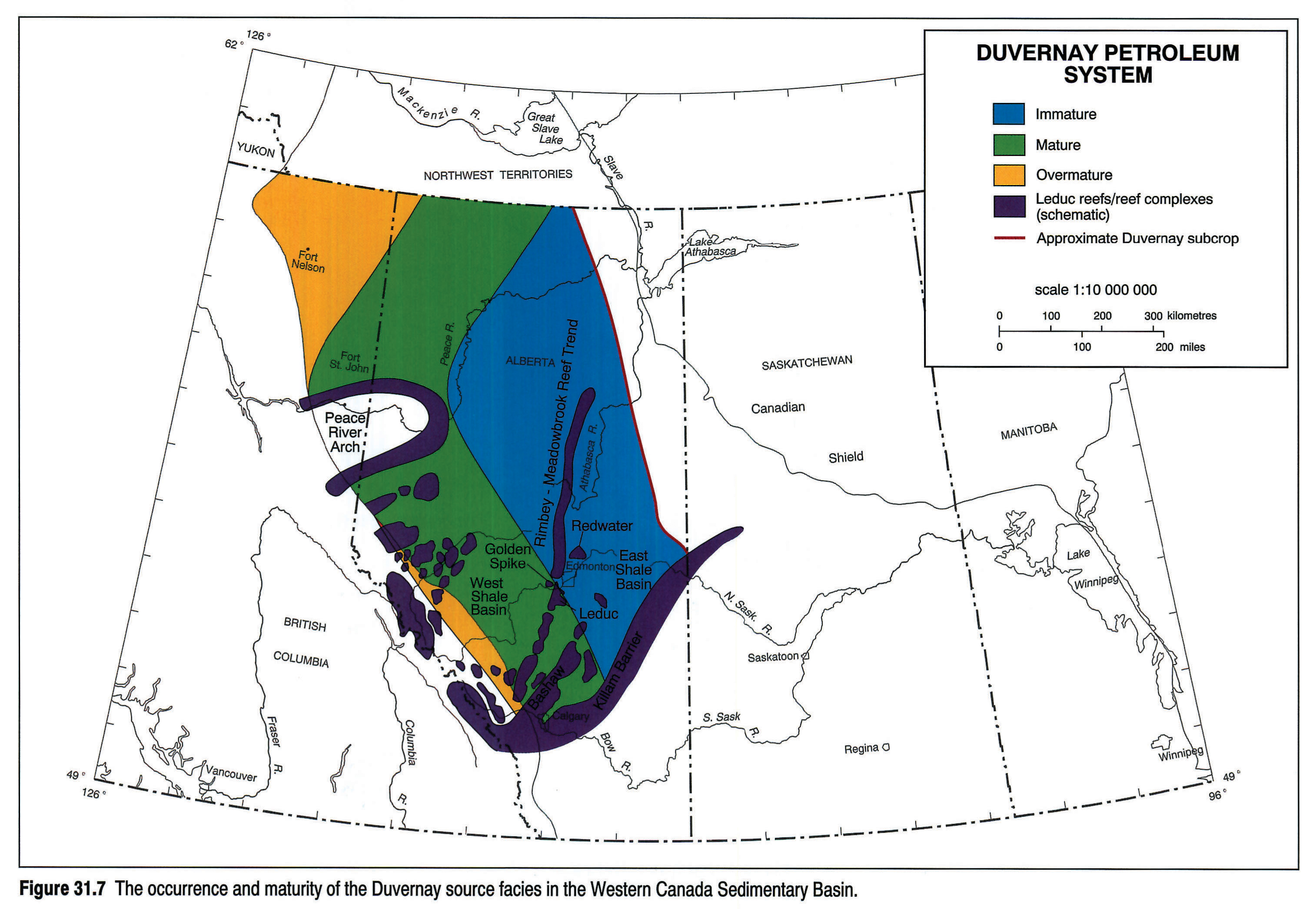
The Duvernay Petroleum System
Source Rocks and Maturity
The Duvernay Petroleum System has been extensively described by Stoakes and Creaney (1984, 1985), Creaney (1989), Creaney and Allan (1990), and Allan and Creaney (1991). The Duvernay was deposited as the basinal time-equivalent of Leduc reef growth during the Frasnian and comprises a sequence of dark brown to black, bituminous, slightly argillaceous carbonates interbedded with gray-green, calcareous shales. These sediments are characteristically organic-rich, with total organic carbon (TOC) values of up to 20 percent, and exhibit plane-parallel, millimetre-scale lamination. In the East Shale Basin (Fig. 31.7), the Duvernay Formation overlies platform carbonates of the Cooking Lake Formation with minor discontinuity and is the basinal equivalent of surrounding lower Leduc Formation reefs. The Duvernay thickens northward and eastward up a depositional slope, passing into lithologies more typical of the overlying lower Ireton Formation, which conformably overlies it elsewhere (see Switzer et al., this volume, Chapter 12). Time-stratigraphic markers in the basinal sequence cut obliquely through the top of the Duvernay Formation, indicating the facies-controlled nature of this upper contact (Stoakes, 1980). Basin filling proceeded from east to west, and the top of the Duvernay Formation also rises stratigraphically in this direction. Where the Cooking Lake Formation is absent, as in the West Shale Basin, the Duvernay conformably overlies rocks of similar basinal aspect, referred to as the Majeau Lake Member. The Majeau Lake Member is the basinal equivalent of the Cooking Lake Platform, and as such, predates reef growth. Lithologically it is identical to the Duvernay Formation. Undoubtedly, the Majeau Lake Member contributed hydrocarbons to the Leduc Formation reservoirs, and for convenience it has been grouped with the Duvernay to the west of the Rimbey-Morinville Leduc reef trend for the purpose of this discussion.
The Duvernay and Majeau Lake units represent accumulations under marine, deep-water, low-energy, basinal conditions. Euxinic conditions are suggested by the absence of fauna, preservation of organic material (Type II oil-prone kerogen), colour of the sediment and the presence of framboidal pyrite. Evidence suggests that euxinic conditions existed in water depths on the order of 100 m in the East Shale Basin (Stoakes, 1980). Undoubtedly the presence of anoxic conditions, combined with slow sedimentation rates within this depositional basin, are the main reasons for preservation of abundant organic material in this rich source rock. Euxinic laminites show the highest TOC's (up to 20 percent by weight), with bioturbated dysaerobic or aerobic sediments exhibiting markedly lower organic contents (less than 1.0 percent by weight).
The Duvernay occurs widely throughout Alberta (Fig. 31.7) although much of it is thermally immature. However, a broad arcuate band of the Duvernay is within the oil window, with the most deeply buried portion being overmature.
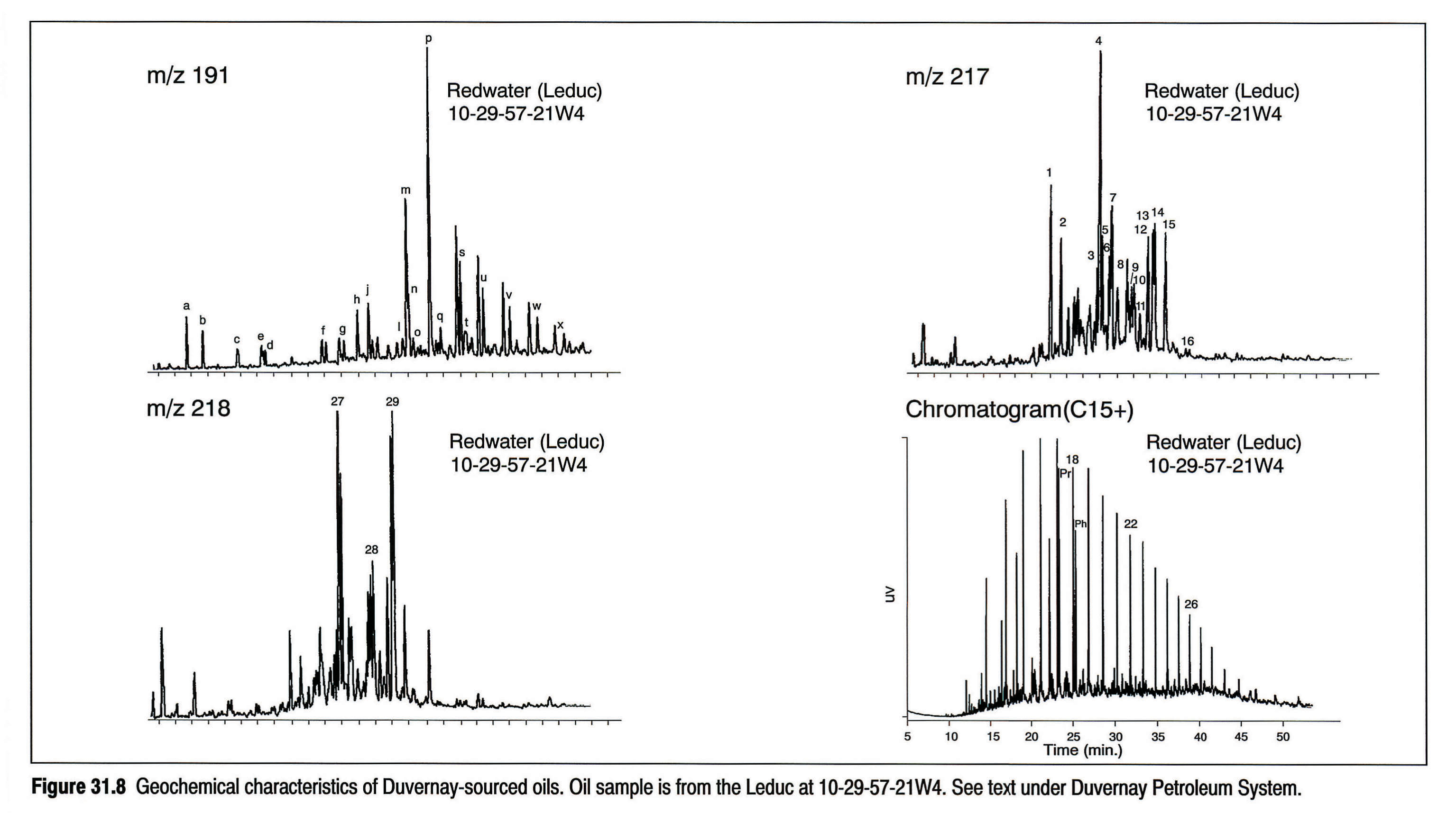
Oil Chemistry and Migration
Creaney and Allan (1990) described the migration pathways of petroleum sourced from the Duvernay, and Allan and Creaney (1991) provided biomarker data for Duvernay-sourced oils. Duvernay-sourced oils are low in sulphur (less than 0.5 percent) and have pristane/phytane ratios of 1.5 to 2.4 (Fig. 31.8), recording source deposition in normal marine salinities in an oxygen-poor environment. The geochemical characteristics of Duvernay oils are shown in Figure 31.8. As outlined by Creaney and Allan (1990) Duvernay-sourced oils have migrated extensively within the Western Canada Basin. In the area of the Bashaw complex and the Rimbey-Meadowbrook reef chain, Duvernay-sourced oils have migrated into Leduc buildups and then, due to geological connectivity, have passed into overlying Nisku platform carbonates. Pools in the Nisku, such as at Leduc-Woodbend, Golden Spike and Chigwell probably have their origin from the Duvernay.
Stoakes and Creaney (1985) provided a detailed description of hydrocarbon migration in the Woodbend Group, principally along the Rimbey-Meadowbrook reef chain. Oils generated from mature Duvernay source facies have migrated locally into porous and permeable dolomitized Cooking Lake platform margins and Leduc reef buildups. This oil then migrated updip along the platform margin, some accessing overlying reefs such as at Leduc, Redwater, and Acheson, with the possibility of further updip migration until it could access the overlying Grosmont Formation and then possibly to subcrop beneath the Mannville. However no Grosmont Formation bitumen samples analyzed to date have shown evidence of a Duvernay origin (Brooks et al., 1990).
Northwest of the Rimbey-Meadowbrook trend, the Nisku shale basin effectively forms a top seal for the Duvernay system in that direction. Thus, Duvernay oil filled Leduc buildups, spilled into underlying Woodbend platforms, and migrated updip to the platform margin. The nature of platform and reef development in western Alberta resulted in 'stacking' of Leduc platforms and reefs directly on Beaverhill Lake platforms. This local stacking geometry combined with regional tilting allowed Duvernay-sourced oil to spill from Woodbend platforms into stratigraphically older Beaverhill Lake platforms in updip positions. This process continued, with oil ultimately spilling into, and filling, Swan Hills buildups at Swan Hills, Judy Creek, Carson Creek, etc., and the Swan Hills platform margin at Deer Mountain. The remaining excess oil spilled into Middle Devonian Gilwood sands and was prevented from further updip migration only by the stratigraphic pinch-out of these sands at Nipisi and Mitsue.
A similar process of stratigraphically down, but structurally updip, migration occurred on the Peace River Arch, resulting in peak maturity (API 40°) Duvernay-sourced oil occuring in Keg River carbonates as far east as Senex. The Keg River shelf margin on the edge of the La Crete Basin provided the ultimate trap for Duvernay-sourced oil in the Peace River Arch area. To the north of the Peace River Arch the Duvernay (termed the "Muskwa" in that area) is depositionally very basinal (Fig. 31.2e shows the Duvernay/Muskwa in the Rainbow area), and is generally isolated from possible reservoirs (i.e., time-synchronous reefs or underlying platforms). This results in very minor oil reserves attributable to this source north of the Peace River Arch. Brooks and Fowler (unpub. data) have observed differences in biomarkers between the Duvernay and Muskwa. For example, Muskwa extracts and associated oils show a C33 hopane prominence, whereas Duvernay samples show no extended hopane prominence.
Overmaturity in the western part of the Western Canada Sedimentary Basin has produced significant gas generation from the Duvernay. In addition, high present-day temperatures have induced the reaction of interbedded anhydrite with hydrocarbon gases to form hydrogen sulphide which, due to the lack of iron in these carbonate systems, has resulted in considerable reserves of sour gas (Krouse et al., 1989).
The "Nisku" Petroleum System
Source Rocks and Maturity
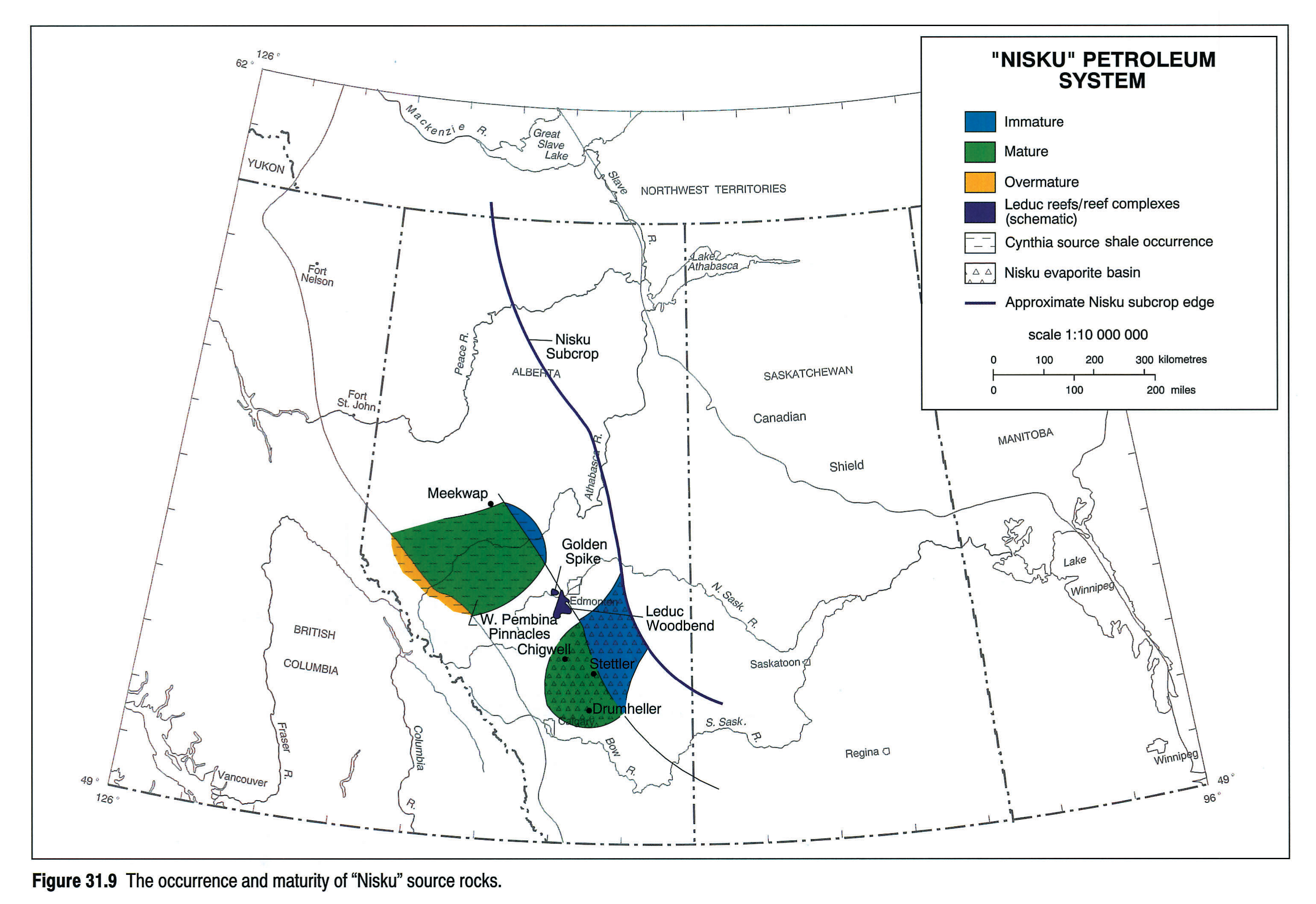
Chevron Exploration staff (1979) reported the basinal Cynthia Member of the Nisku Formation as the likely source of oils pooled in Nisku pinnacles in the Nisku shale basin. Cores in this particular source rock are not available and therefore corroborating data for source potential in the Cynthia are lacking. TOC's have been reported up to only 2 percent. Thus, the actual correlation of the Cynthia Member to Nisku pinnacle oils is not definitive. This system is therefore given a more generic "Nisku" name pending data corroborating the precise source rock interval for the pinnacle oils. Figure 31.9 shows the occurrence and maturity of Nisku source rocks in the Western Canada Basin.
Oil Chemistry and Migration
The Nisku pinnacle oils of West Pembina show a progressive increase in API gravity from northeast to southwest along the trend, which supports local sourcing from Nisku basinal shales. Allan and Creaney (1991) described oils presumed to be sourced from these Nisku basinal shales. The geochemistry of this oil family is summarized in Figure 31.10. Geochemical data on whole oils are very similar to those for oils from the Duvernay. The terpane data are dissimilar, however, reflecting some differences in the bacterial populations extant during Nisku and Duvernay accumulation (Allan and Creaney, 1991).
Certain Nisku oils in the Stettler and Drumheller areas show characteristics of having been sourced from an evaporitic environment (i.e., pristane/phytane less than1.0, even/odd predominance, etc.) rather than from an open-marine source (Cynthia or Duvernay), and may attest to a source(s) being present in the Nisku evaporitic basin shown in Figure 31.9. In addition, as mentioned earlier, some oils in the Nisku are part of the Duvernay Petroleum System (Golden Spike, Leduc-Woodbend, etc.).
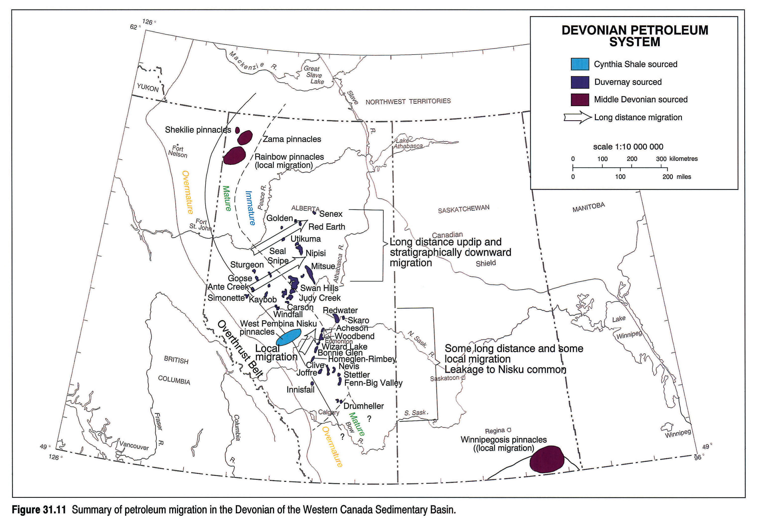
To summarize the Devonian section, the migration of oils in all Devonian systems is shown in Figure 31.11.
The Exshaw-Bakken and Lodgepole Petroleum Systems
Source Rocks and Maturity
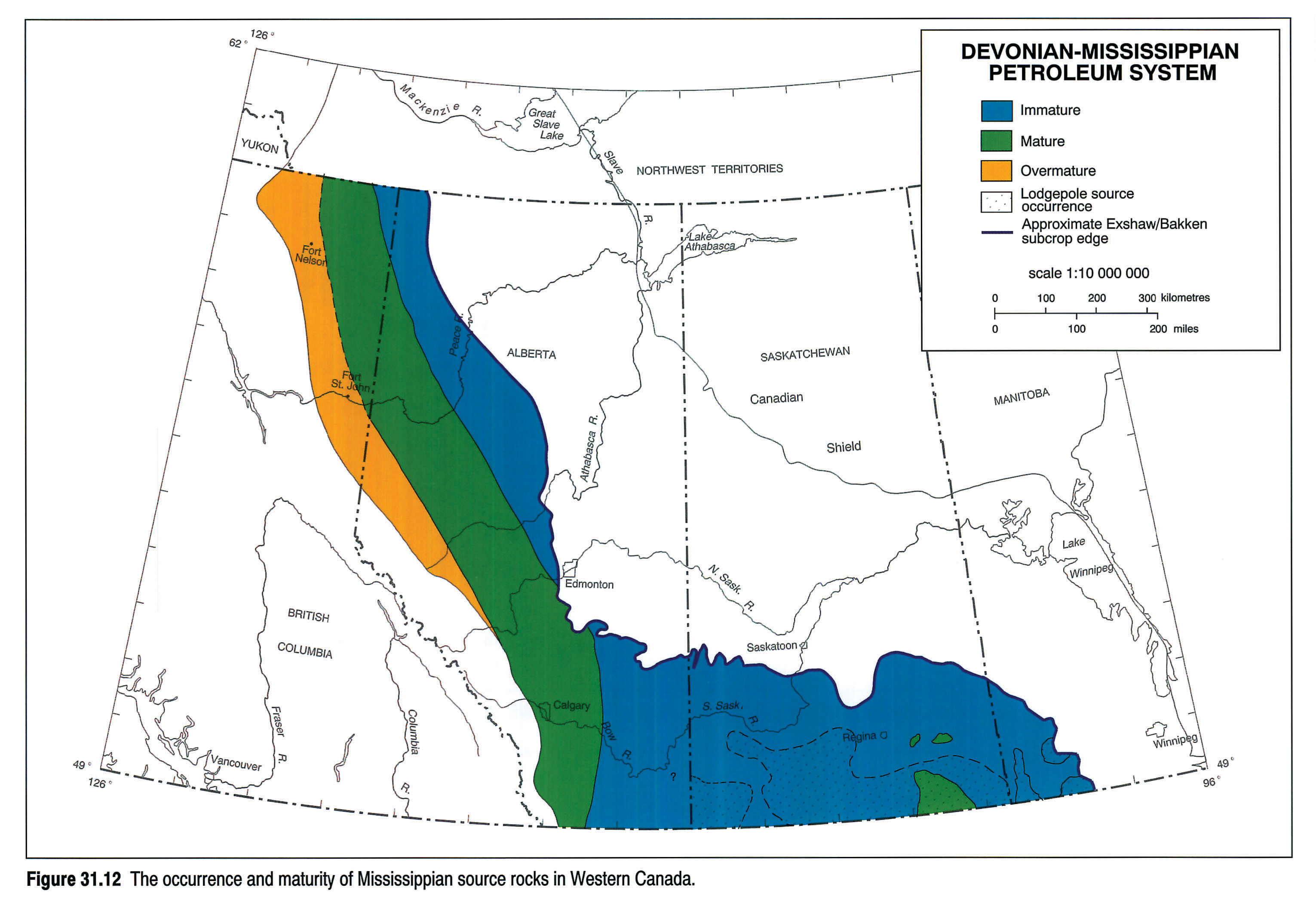
Significant, organic-rich, marine, source rock development occurs throughout the Western Canada Sedimentary Basin in the lower part of the Exshaw-Bakken (Devonian-Mississippian) system. Three formations consist of organic-rich, black, basinal laminites: the Exshaw, the Bakken (upper and lower members), and the Mississippian basal Lodgepole formations (see Richards et al., this volume, Chapter 14). The geochemistry of these source rocks has been documented by Webster (1984, Bakken), Leenheer (1984, Bakken and Exshaw), Price et al. (1984, Bakken and Exshaw), Osadetz and Snowdon (in press, Bakken and Lodgepole), Creaney and Stoakes (1987, Exshaw), and Creaney and Allan (1990, Exshaw).
The above authors indicate average TOC's of up to 12 percent for the lower member of the Bakken, 17 to 63 percent for the upper member of the Bakken, up to 5 percent for the Lodgepole, and values up to 20 percent for the Exshaw. In all cases the hydrogen indices suggest a predominantly marine, Type II organic matter. Source rock thicknesses are 3 to 10 m for the Bakken members, less than 10 m for the Exshaw and up to a few tens of metres for the Lodgepole. The distribution and maturity of Devonian-Mississippian sources are shown in Figure 31.12. The actual distribution, regional maturity and richness variations for the Lodgepole source are relatively poorly understood because of a paucity of cores and thus have only been sketched on Figure 31.12. The Lodgepole appears, from extract analysis, to be capable of expelling liquid petroleum at lower levels of maturity than the Bakken, as indicated on Figure 31.12.
Oil Chemistry and Migration
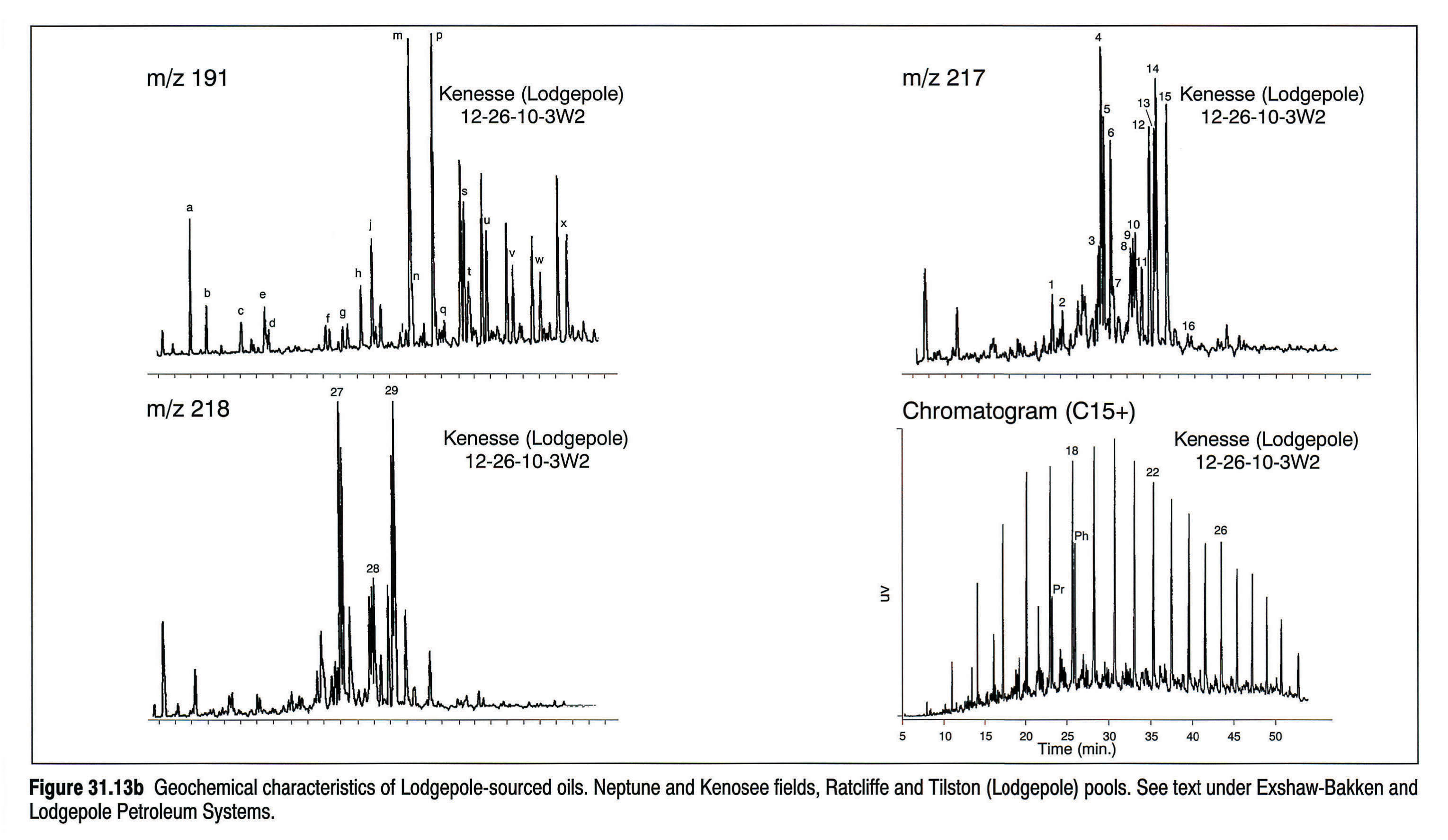
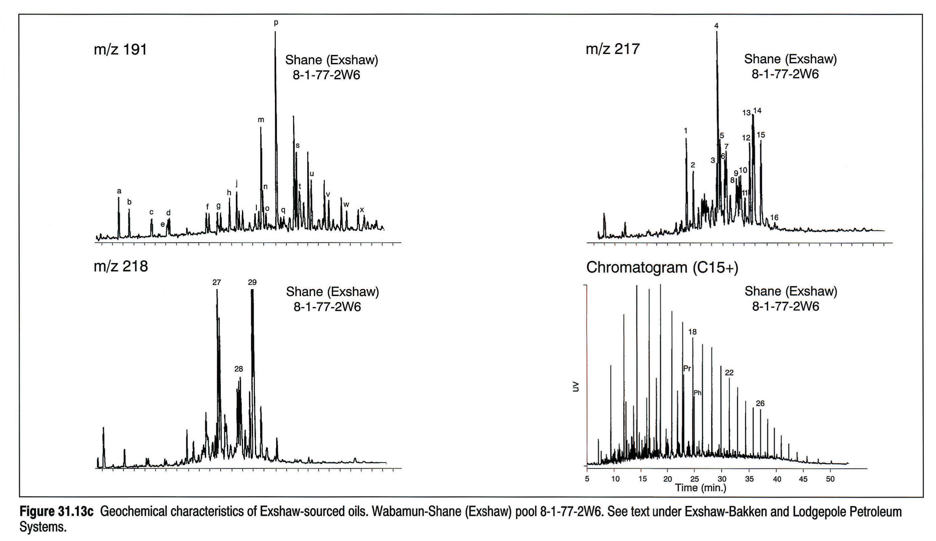
Osadetz et al. (1991) considered the majority of oils in the Williston Basin portion of the Western Canada Sedimentary Basin to have been sourced from Mississippian source rocks. Unlike most previous workers, however, they consider the Lodgepole rather than the Bakken to be responsible for the bulk of the reserves. Bakken-sourced oils are characterized by pristane/phytane ratios greater than 1 whereas Lodgepole oils have a pristane/phytane ratios less than 1, an even/odd paraffin predominance, and a C35 prominence amongst the extended hopanes. Figures 31.13a, 31.13b, 31.13c summarize the geochemical characteristics of Bakken-, Lodgepole-, and Exshaw-sourced oils.
Figure 31.14 shows the currently known extent of petroleum dispersion in the Devonian-Mississippian Petroleum System. According to Osadetz et al. (1991) the Bakken can only be ascribed as source to a limited number of pools (e.g., Roncott, Rocanville and Daly) with the Lodgepole being the source of the majority of Mississippian pools. Impaired expulsion from the Bakken may explain both this observation and the current exploration interest in the Bakken Shale itself as a horizontal drilling target.
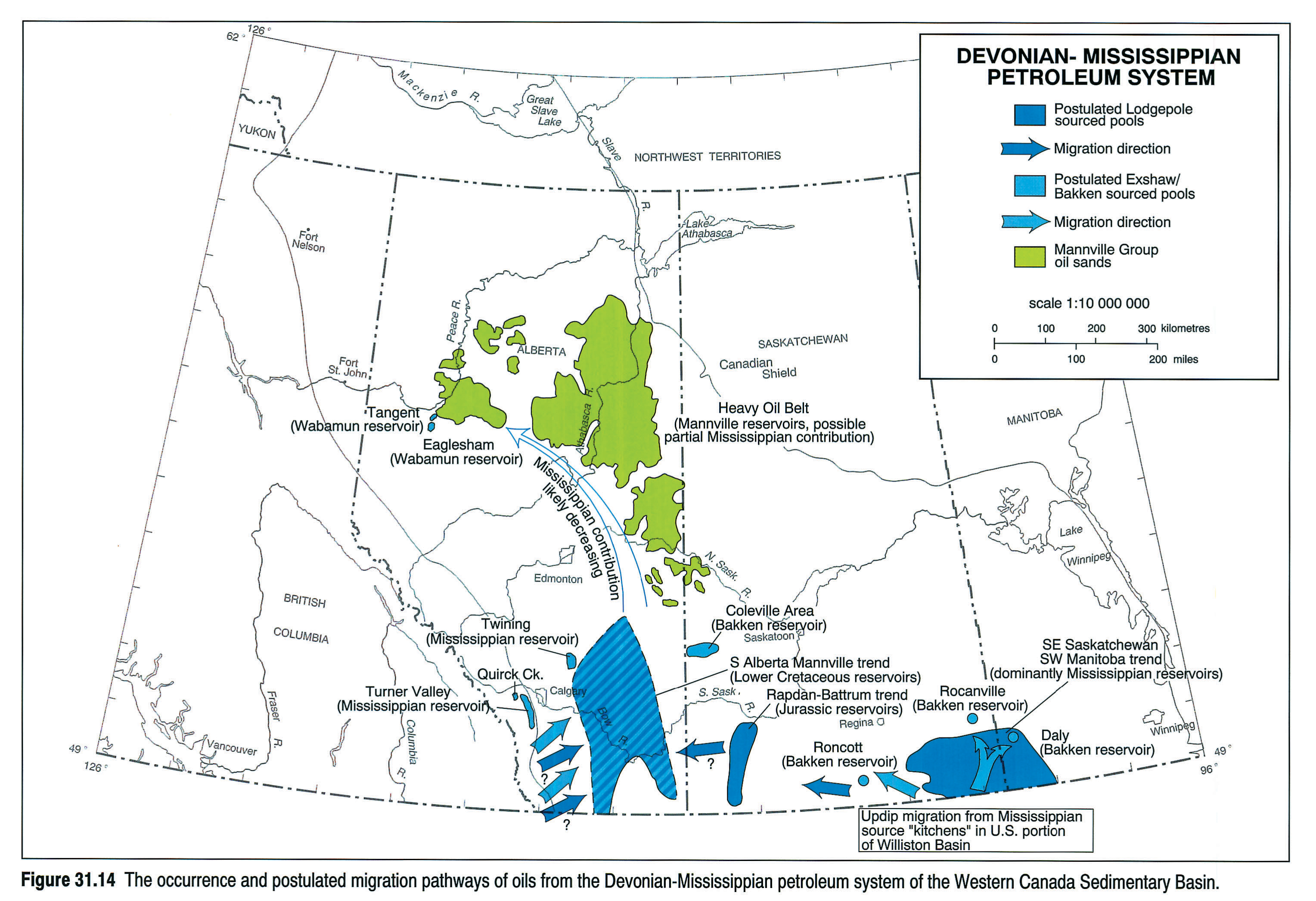
The Jurassic and Lower Cretaceous pooled oils of the Rapdan-Battrum trend are also Lodgepole-sourced (Osadetz et al., 1991), as are some Mannville oils of southern Alberta. However, in southern Alberta, other Mannville oils have a strong Exshaw signature and Leenheer (1984), Creaney and Allan (1990), and Allan and Creaney (1991) have suggested the Exshaw as at least a partial contributor to the heavy oils of the Athabasca/Cold Lake/Lloydminster areas.
In the Fort St. John Graben area, Piggott and Lines (1990) ascribed the occurrences of gas in the Wabamun-to-Belloy section as derived from the Exshaw at advanced maturity.
The Doig Petroleum System
Source Rocks and Maturity
The basal, phosphatic and radioactive facies of the Middle Triassic (Anisian) Doig Formation is a prolific oil-prone source rock within the Triassic section of the Western Canada Sedimentary Basin (Creaney and Allan, 1990; Riediger et al., 1989, 1990a). TOC's up to 11 percent and hydrogen indices up to 480 have been reported from peak maturity sections (Riediger et al., 1990a; Riediger, 1990; Creaney and Allan, 1992). The occurrence and regional maturity of the basal Doig source are shown in Figure 31.15. Pooled oils ascribed to this source are also annotated on Figure 31.15. The organic matter type of the basal Doig source facies is typically marine, Type II, consisting of marine algal material and bituminite (Riediger et al., 1990a)
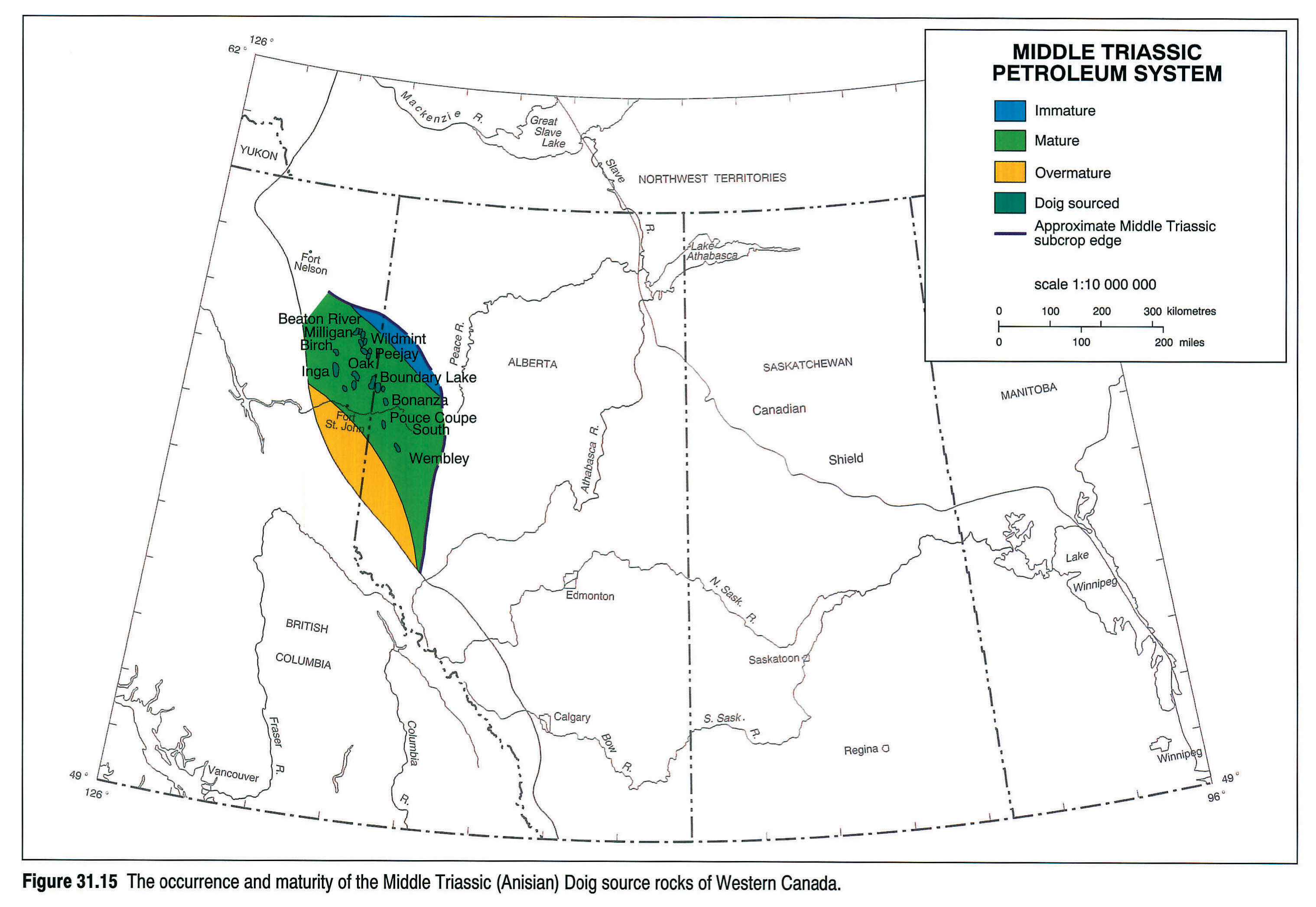
In addition to this important, basal Doig source, other organic-rich intervals occur throughout the Doig and overlying lower Halfway formations in westerly (distal) regions (e.g., in outcrop) of the basin. The underlying, Lower Triassic Montney Formation also contains evidence of source potential, with TOC's up to 5 percent reported (Riediger, 1990; Riediger et al., 1990a). Very high residual TOC values (up to 6.5 percent), in the Upper Triassic Pardonet Formation in outcrop, suggest that this unit likely also generated significant amounts of hydrocarbons as it passed through the oil window. The source potential of these other Triassic units is poorly understood in a regional sense, in part because of the fact that these organic-rich facies are presently preserved only in late mature to overmature regions of the basin.
Oil Chemistry and Migration
Almost all of the oils analyzed to date from Triassic reservoirs are sourced from the basal phosphatic facies of the Doig Formation; however, minor volumes in some Upper Triassic reservoirs are sourced from the overlying Jurassic "Nordegg" Member, and are discussed below. Doig-sourced oils are moderately sulphur-rich (up to 1 percent by weight total sulphur), are generally between 35 and 45° API gravity, and are reasonably distinctive from a biomarker point of view. Diagnostic biomarker characteristics of these oils include pristane/phytane ratios around 1-1.5, high amounts of tricyclic terpanes relative to pentacyclic terpanes, and high diasterane to regular sterane ratios. Figures 31.16a and 31.16b are a geochemical summary of Doig-sourced oils.
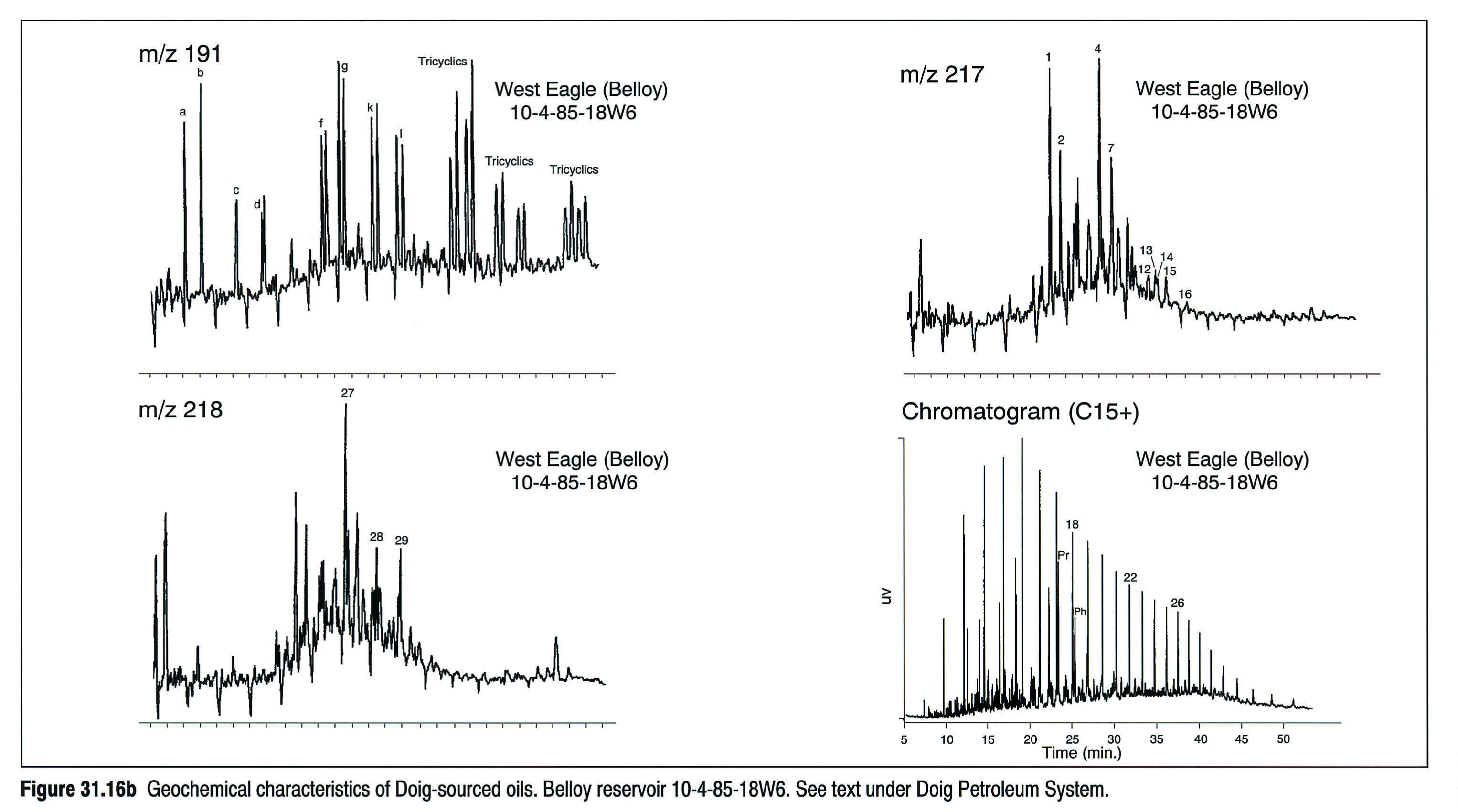
Du Rouchet (1985) used aromatic hydrocarbons to suggest the Triassic as a source of the heavy oil deposits of eastern Alberta. This is not supported by more recent biomarker work (Riediger et al., 1990a; Allan and Creaney, 1991; Brooks et al., 1989).
The "Nordegg" Jurassic Petroleum System
Source Rocks and Maturity
The Lower Jurassic of Western Canada contains a highly oil-prone marine source unit, the "Nordegg" Member of the Fernie Formation. The "Nordegg" is probably of Pliensbachian age (Poulton et al., 1990), and consists of dark brown to black, variably phosphatic marlstone and calcareous mudstone with a very high gamma-ray response on geophysical logs. "Nordegg" Member is used in quotation marks to indicate the uncertainty in stratigraphic equivalence of this subsurface unit to the type section of the Nordegg Member in outcrop (see Poulton et al., 1990 for discussion of Jurassic stratigraphy). As indicated by several workers (e.g., Poulton et al., 1990; Riediger, 1991), from west-central to southern Alberta, the "Nordegg" Member undergoes a facies change to a more proximal, brecciated and in part karsted chert- and sand-rich lithofacies, and the oil-source character is progressively diminished (see Poulton et al., this volume, Chapter 18).
Other potential source rocks of Jurassic age include the Toarcian Poker Chip or Paper shales of southern Alberta (Stronach, 1984 reported TOC's up to 4.9 percent; Creaney and Allan, 1992 reported TOC's up to 5.1 percent), and Upper Jurassic (Kimmeridgian age) shales in the Fernie Formation (TOC's up to 4.4 percent reported by Rosenthal, 1989). No detailed geochemical studies of these other units are publicly available, however, and thus their actual hydrocarbon potential remains unknown.
Figure 31.17 shows the distribution and maturity of Lower Jurassic source rocks in Western Canada. As noted above, the presence of oil source rocks south of about 54°N latitude is only implied by published TOC data.
Oil Chemistry and Migration
The geochemical characteristics of "Nordegg"-sourced oils are shown in Figures 31.18a and 31.18b. They are usually extremely sulphur rich (up to 4 percent by weight), and show methyl- and ethyl-cholestane relative abundances characteristic of Jurassic sources (Grantham and Wakefield, 1988). In addition, diasteranes are present in relatively low quantities compared to regular steranes. The 17α (H)21β (H) norhopane is particularly abundant and the C35 hopane shows a relative predominance over the other extended hopanes.
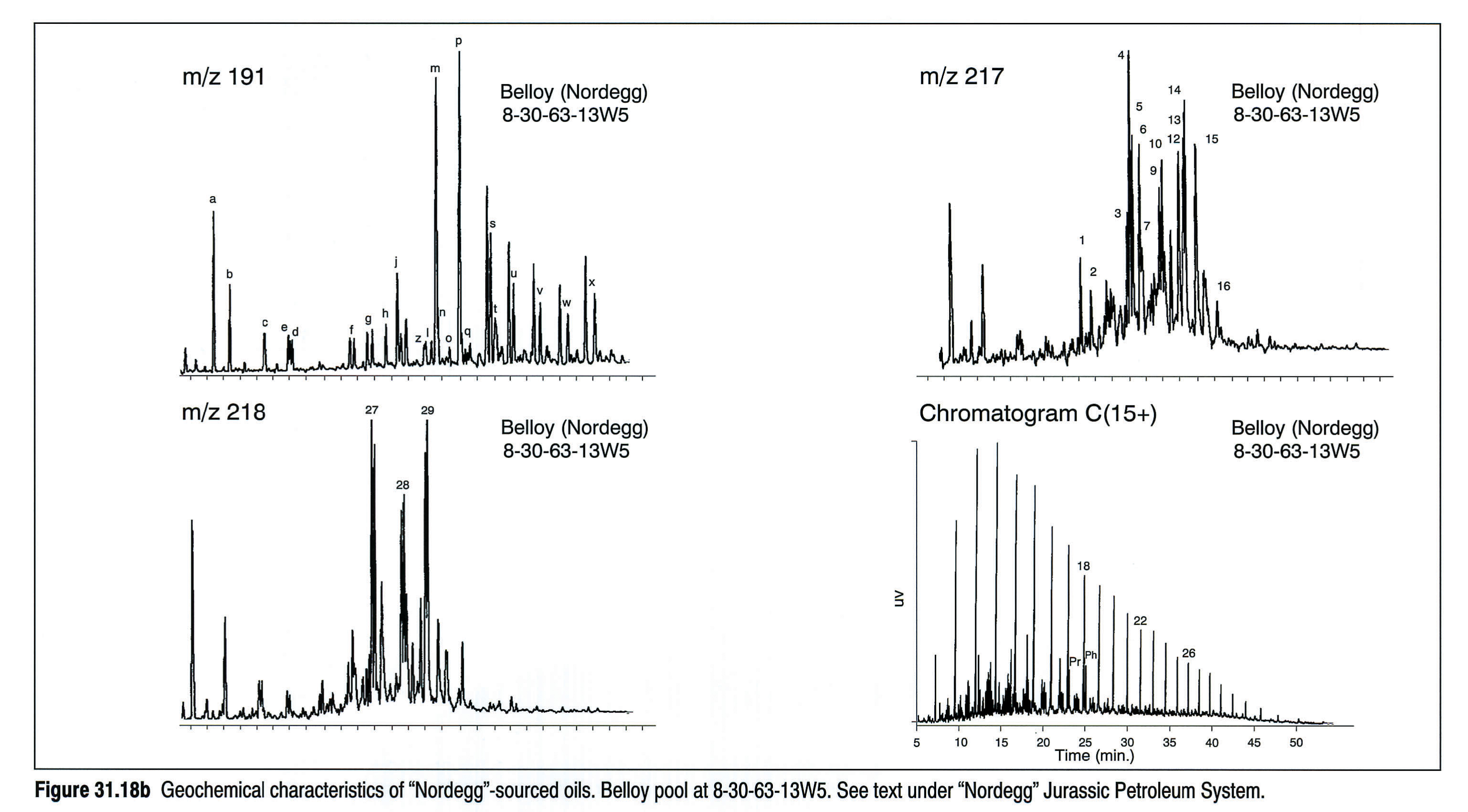
The "Nordegg" rests unconformably on Triassic and older formations, and acts as both source and top seal for some conventional hydrocarbon accumulations (e.g., Rycroft-Charlie Lake, Virginia Hills-Permian Belloy, Cherhill-Mississippian Banff; Figure 31.19). Oils in these pools have properties that reflect the biomarker composition and thermal maturity of the immediately overlying "Nordegg" source rocks, implying minimal lateral migration.
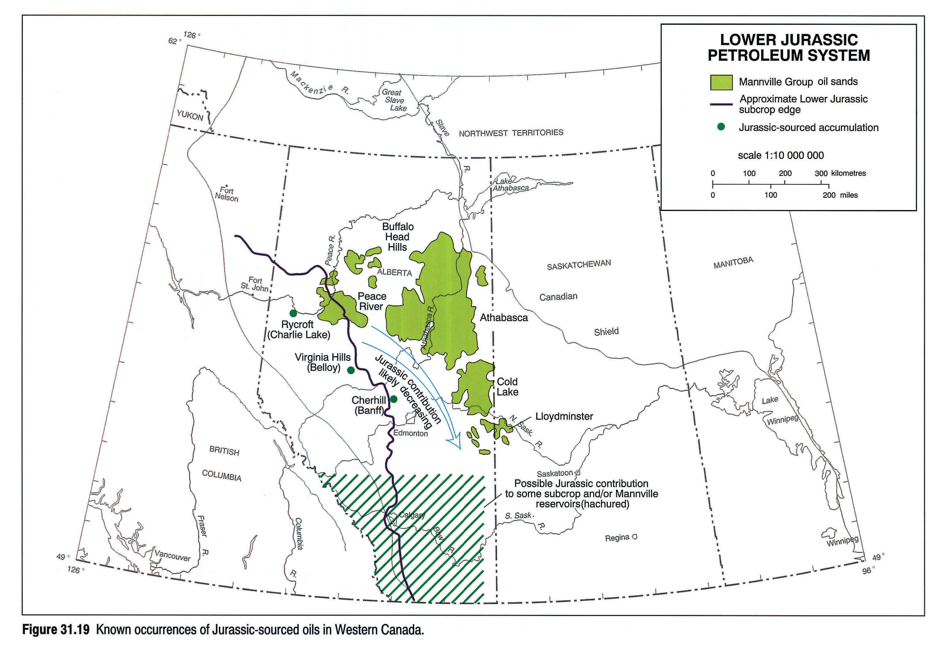
Figure 31.19 is a summary of the known occurrences of "Nordegg"-sourced oil. Considering the richness of the "Nordegg", it is surprising how few conventional oils have unequivocally been correlated to this source rock. The fate of "Nordegg"-generated hydrocarbons is of some debate, even within this group of authors. Some of us (Creaney, Allan, Cole) believe that much of the "Nordegg"-sourced oil is channelled updip in sandier interbeds of the Fernie Group, eventually being trapped in, and contributing a large volume of oil to, the Lower Cretaceous tar sands and heavy oil deposits on the eastern side of the Alberta Basin. Others (Brooks, Fowler, Macqueen, Riediger, Snowdon) note a lack of similarity between biomarker characteristics of the "Nordegg" extracts and the Lower Cretaceous deposits (e.g., Fowler et al., 1989; Riediger et al., 1989, 1990b), and instead suggest that the bulk of the oil generated by the "Nordegg" was not expelled. Thus the "Nordegg" could be a possible target for fractured shale exploration, similar to the Bakken Formation in the Williston Basin.
The Mannville Petroleum System
Source and Maturity
The earliest deposits of the foreland basin are dominated by deltaic/coastal plain sedimentation, and are characteristically coal rich. Welte et al. (1984) provided an excellent geochemical description of this part of the section in the Elmworth area. Furthermore, these coals are mined at outcrop in the Disturbed Belt and their petrographic composition is well described (Cameron, 1972; Kalkreuth, 1982). The coals are notably low in liptinite and commonly rich in inertinite (see Smith et al., this volume, Chapter 33). Pyrolysis analyses shows Mannville sediments to contain primarily Type III kerogen, which led Welte et al. (1984) to conclude that they are very potent gas sources, particularly at the advanced levels of maturity found in the Deep Basin (Kalkreuth and McMechan, 1988). Welte et al. (1984) further suggested that the 17 TCF of proven and probable natural gas in low-porosity Lower Cretaceous sands of Western Canada's Deep Basin was largely generated from local, high-maturity coals and migrated into adjacent low-porosity and permeability sands. Masters (1979) had earlier proposed that these gases are hydrodynamically trapped, given that the sands are water filled updip from the "tight gas sands."
TOC values in associated shales are commonly below 2 percent, with very low hydrogen indices (Moshier and Waples, 1985). However, the presence of locally restricted, delta-plain and lacustrine shales containing concentrated amounts of liptinites or sapropelic material cannot be discounted. Hence, localized oil or condensate with commercial potential may exist. Figure 31.20 is a maturity map of the Mannville based on coal vitrinite reflectances and compiled from a variety of sources.
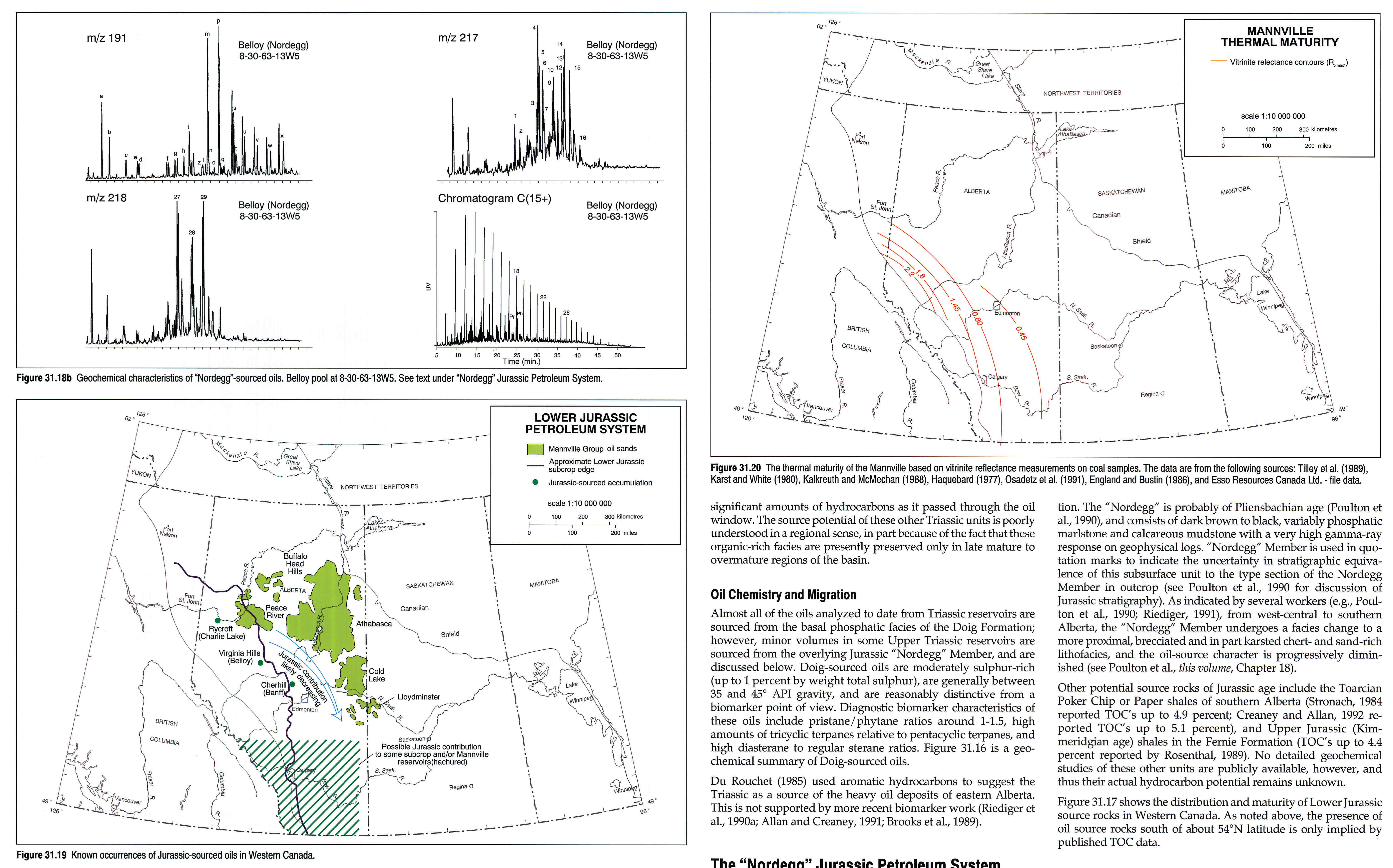
In the very northern portion of the Western Canada Sedimentary Basin, the Mannville delta-fronts grade into prodelta and ultimately distal, marine sediments that develop oil-source potential. This has been observed in the Northwest Territories in the Slater River shale at the East Mackay B-45 well (Feinstein et al., 1988).
Migration
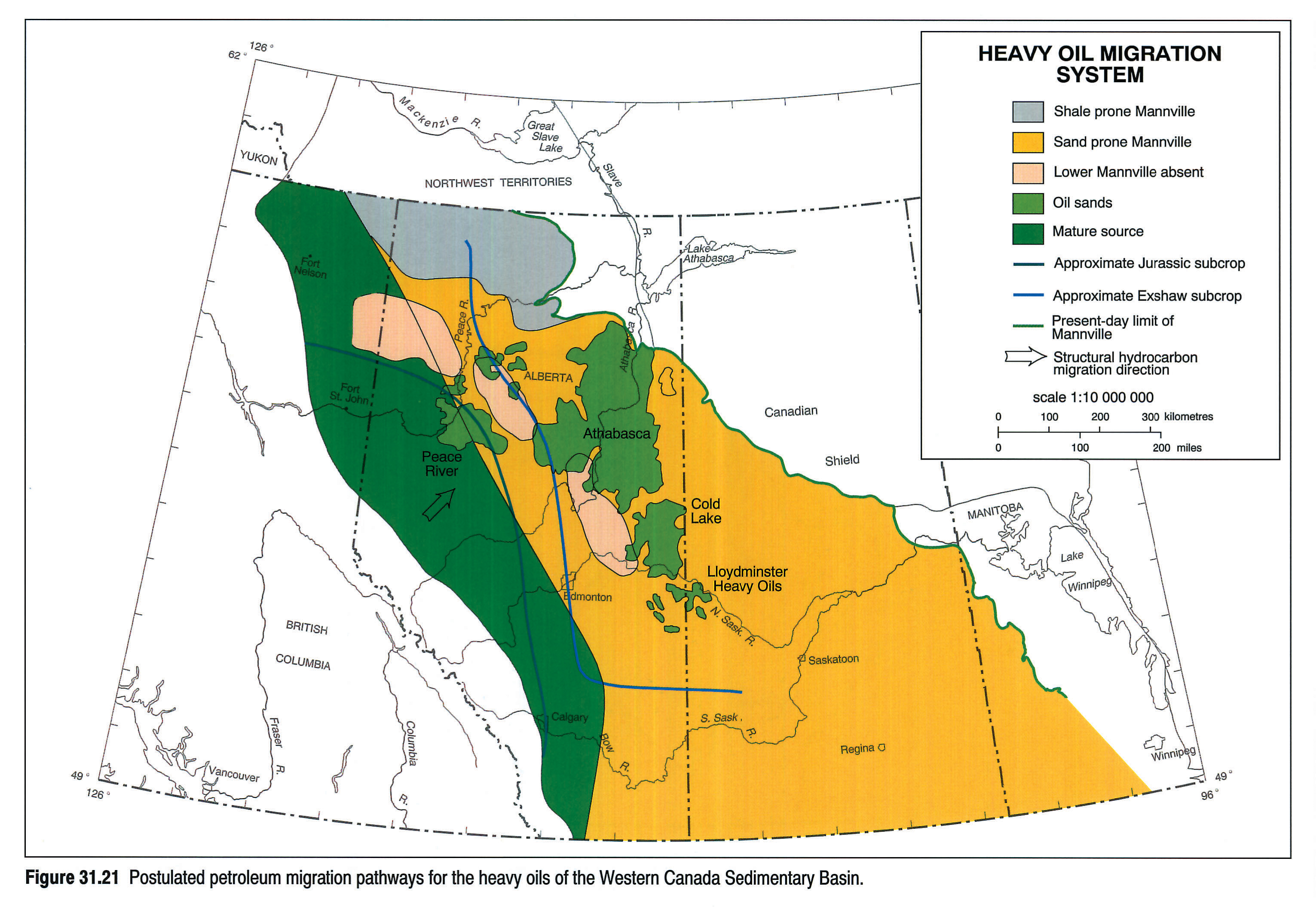
The Mannville section in Western Canada performs a double role relative to petroleum distribution. The Mannville Petroleum System consists largely of internally sourced and pooled gas (highly mature coal gas in the west grading to bacterial gas in eastern Alberta). In addition the basal Mannville sand-prone section has acted as a "collector" for prodigious volumes of oil (see Hayes et al., this volume, Chapter 19) from pre-Mannville source rocks. There are currently two schools of thought on the origin of the vast reserves (~1.8 trillion barrels) of heavy oil in the Mannville-Grosmont reservoirs and both schools are represented within the authorship of this chapter.
Creaney and Allan (1990), Allan and Creaney (1991), and Creaney and Allan (1992) consider these huge deposits to be a mixture of oils leaking from the immediately underlying section with principle contributions coming from the Jurassic ("Nordegg" and possibly younger Jurassic) as well as the Mississippian (Exshaw/ Bakken). In addition, there are other subcrops that are connected to the Mannville; for example, Nisku and Triassic (very limited) that could, on geological grounds, have leaked oil to the Mannville, but no geochemical evidence is known to support this. In contrast, Brooks et al. (1988, 1989, 1990) analyzed samples from each heavy oil deposit and, recognizing the strong similarity amongst them, concluded that they must belong to a single family with a unique source. To date this source has not been identified. Biomarker studies indicate no clear-cut correlation between conventional oils and their known source rocks and these bitumen deposits (Brooks et al., 1990). Figure 31.21 summarizes the occurrence of heavy oils in Western Canada and suggests one possibility for their source and migration from Jurassic and Mississippian sources.
The Colorado Group Petroleum System
Source and Maturity
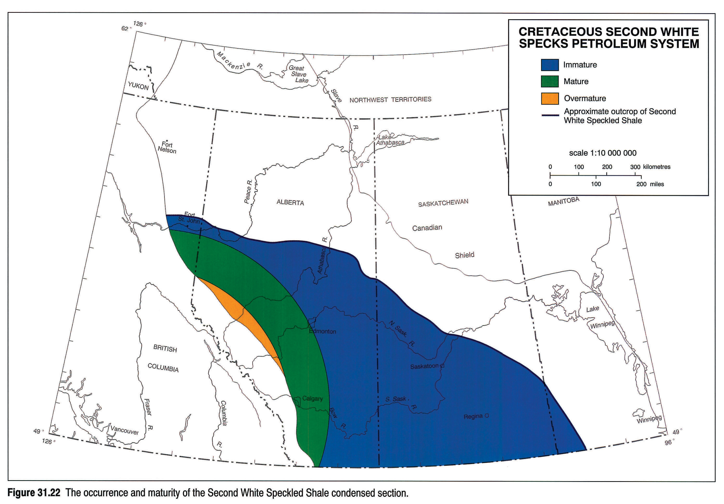
The Colorado Group of Late Cretaceous age is a thick, marine shale and siltstone succession that contains several oil-source horizons (see Fig. 31.2a; and Leckie et al., 1990). In the southern part of the basin, two principal effective source zones are the Second White Speckled Shale (Cenomonian/Turonian) and the Fish Scales Zone (Albian/ Cenomanian). Both contain marine, Type II organic matter with TOC's up to 12 percent and hydrogen indices up to 450 where immature (Allan and Creaney, 1988). Between the condensed sections are other effective marine, though less rich, source intervals, where TOC's are in the 2 to 3 percent range and hydrogen indices range up to 300. In the central part of the basin, the younger First White Speckled Shale condensed section (Santonian) becomes more organic-rich and develops source potential. This is normally less prominent on natural gamma-ray logs than the older condensed sections, but has source quality characteristics similar to the older Second White Speckled Shale.
Colorado Group shales are mature in the most westerly part of its zone of occurrence, adjacent to the Disturbed Belt (see Fig. 31.22). Peak maturity of the Second White Speckled Shale and the Fish Scales Zone lies close to the Disturbed Belt in the southern part of the basin. Passing northward, deeper maximum burial causes these two source zones to trend toward overmaturity and the First White Speckled Shale then becomes mature along the basinal axis. In central Alberta, the maturity contours swing east-west and run into the Disturbed Belt. Thus there is a broad area from central Alberta north to outcrop where the Colorado Group is immature. Very low maturities are present throughout Saskatchewan, and the condensed sections discussed above have been locally classified as oil shales (Macauley, 1984a, b; Macauley et al., 1985). To date, organic enrichment has been observed to occur at the base of the Shaftesbury (northern Alberta; Leckie et al., 1990) and at the Base of Fish Scales, Second and First White Speckled Shales (see Fig. 31.2a).
Oil Chemistry and Migration
Without exception, all oils pooled in Viking and all younger sands are sourced from the Colorado Group shales. These are sweet, high quality crude oils, with sulphur contents usually less than 0.4 percent by weight.
Steranes of Colorado Group-sourced oils consistently have a C28>C29>C27 relative abundance (Fig. 31.23), as do steranes in organic extracts of the shales themselves. The transition from the C29>C27>C28 relative pattern of all older source rocks and their oils to the Colorado Group distribution occurs in Albian rocks and has been documented in core extracts (Creaney and Allan, 1992). The change in sterol abundances is likely related to the emergence of coccolithophorids and silicoflagellates as prominent contributors to the steroidal budget of marine muds (Grantham and Wakefield, 1988). Indeed, the predominance of the C28 steranes appears to be a worldwide phenomenon characteristic of Late Cretaceous marine source rocks.
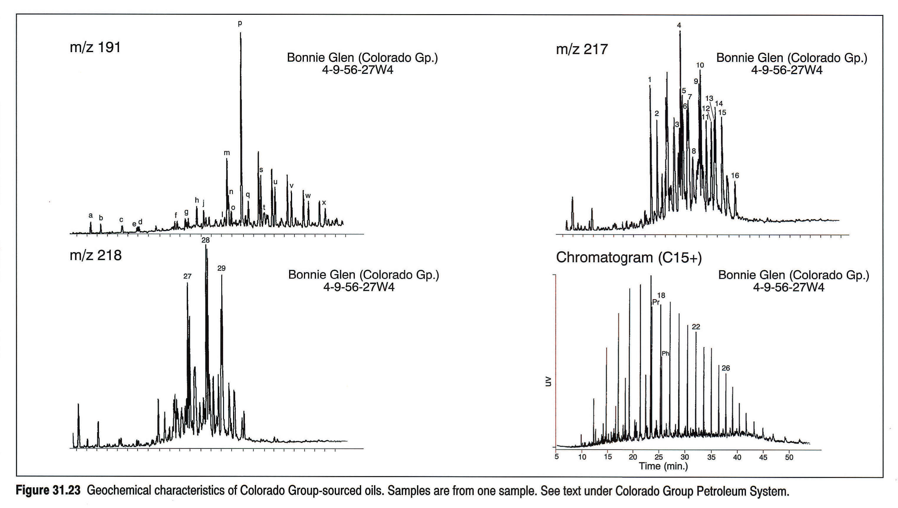
As previously stated, all oils found in Viking-Belly River reservoirs are sourced from the Colorado Group. Furthermore, Colorado Group-sourced oil has not been documented in any Mannville or older sediments. Thus, there appears to be a basin-wide, hydraulic barrier between the Viking-Belly River reservoirs and Mannville and older sediments. Stratigraphically this corresponds to the Albian Lower Shaftesbury/Joli Fou formations (Allan and Creaney, 1988; Creaney and Allan, 1990). The lack of any correspondence in either degrees of oil alteration or geographic distribution of altered oils above and below these shale formations strongly supports the concept that this level represents an oil, water and perhaps gas permeability barrier.
Viking oils, which are widespread across southern Alberta and eastern Saskatchewan, have been sourced from mature Cenomanian-aged shales of the Colorado Group adjacent to the foothills of southern Alberta.
Cardium oils lie in traps localized at or below erosion-transgression surfaces, as described by Plint et al. (1986) and Walker (1988). The major Cardium accumulation is the giant Pembina Field, which lies in regressive sands situated below the transgressive conglomerates on the E5 surface (Plint et al., 1986). The bulk of the oil is peak maturity liquid derived from the Second White Speckled Shale some considerable distance downdip from the reservoirs (Allan and Creaney, 1988). Similar oil is found at Cynthia/Pembina, Keystone, Carrot Creek and Willesden Green. A number of Cardium pools occur in sandstone associated with surfaces other than the E5. Examination of their geochemical properties (maturity and biomarker profiles) suggest that they are pooled close to their sources, and are most likely derived from shales adjacent to their reservoir sands. The maturities of these oils (Kakwa, Garrington and Crossfield fields, for example) are similar to the maturities of closely adjacent shales.
Oils in Belly River channel and shoreline sands in central-southern Alberta are commonly peak-maturity liquids and are very similar to oils in underlying Cardium pools. Quantitatively, total reserves represent only a small fraction of the Cardium reserves. They can be considered as a small amount of "overspill" oil from the Second White Speckled Shale, which failed to access Cardium sands. Thus, a considerable cross-stratal component exists for the secondary migration pathway of Belly River oils, coupled with a significant amount of updip migration once the oil accessed channel sand. Figure 31.24 summarizes migration pathways in Colorado Group reservoirs.
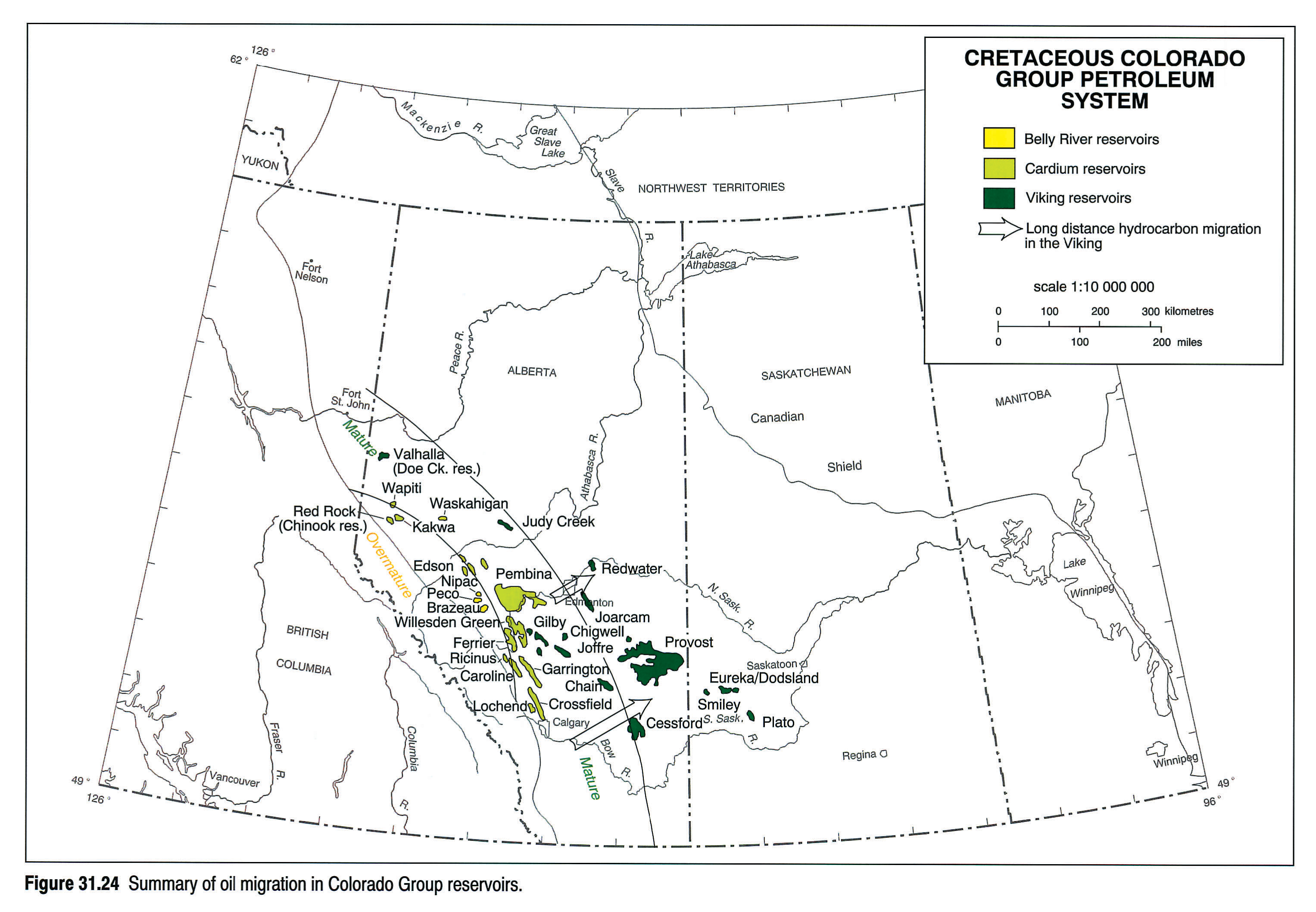
Fuex (1977) published isotope analyses for several Western Canada gases, including some from the large (3 TCF) gas pool at Medicine Hat in the Milk River Formation. This gas is biogenic (generated by bacterial decay rather than thermal degradation), and was probably sourced from adjacent Colorado Group mudstones (including the First White Speckled Shale condensed section). Much of the very dry gas (methane only) of eastern Alberta is probably of this origin. This has an interesting implication for petroleum migration because it begins to fill trap volume almost immediately after reservoir deposition, which could leave certain traps full of gas prior to the later arrival of oil. This oil would then fail to "see" the trap and might be facilitated in it's long distance lateral migration.
Petroleum Alteration
Milner et al. (1977) outlined the processes that can alter or degrade an accumulation of oil. Two of these processes have had a significant impact on the original reserves of the Western Canada Sedimentary Basin:
Biodegradation. Biodegradation is the action of microbes on accumulated oil, resulting in the oil's degradation to heavy oil. Degradation is caused by the incursion of oxygenated meteoric water from outcrop areas into reservoirs and is a combination of aerobic and anaerobic microbial processes. Biomarker evidence shows that several different biodegradation pathways must be occurring in these deposits (Brooks et al., 1988, 1989). In Western Canada this has happened to approximately 98 percent of the oil originally in place as conventional reserves and has produced the giant oil sands deposits at Buffalo Head Hills, Peace River, Athabasca-Wabasca, Cold Lake and Lloydminster. These occur in Lower Cretaceous (Mannville) and Carboniferous and Devonian ("carbonate triangle") intervals.
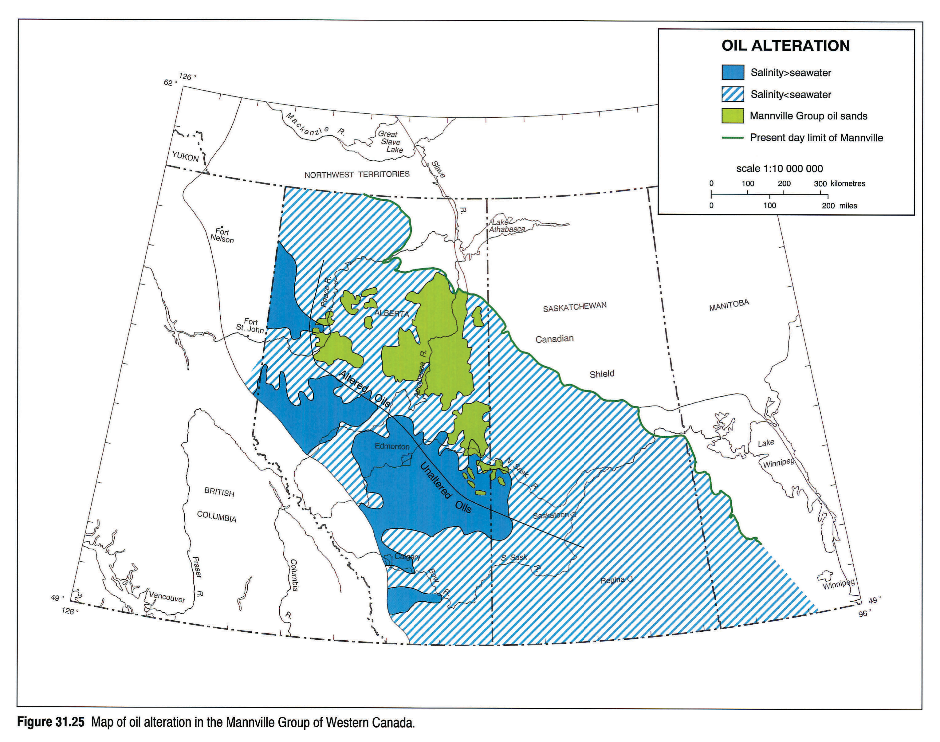
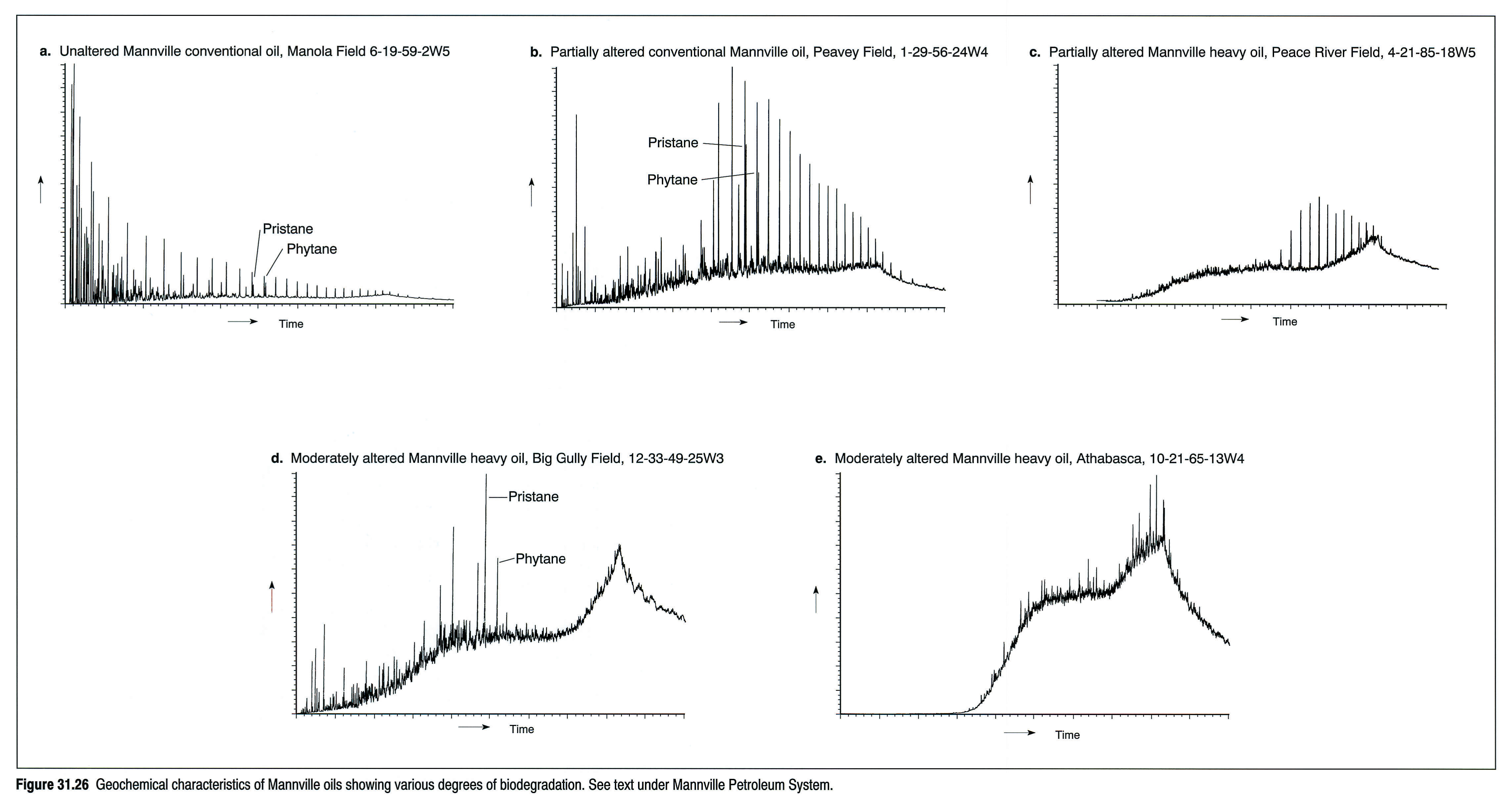
Figure 31.25 is a map of oil alteration (via biodegradation) and formation water salinity in the Mannville of Western Canada. It is the excellent reservoir quality and continuity of the basal Mannville section that has allowed both the long-distance migration of oil and the considerable ingress of meteoric water required for biodegradation. Oils that occur in subcrops beneath the Mannville (for example, Grosmont, etc.) are also biodegraded where fresh water has travelled down from the Mannville. Figure 31.26 is a montage of geochemical data showing sequential biodegradation of Mannville oils. Biodegradation is most severe in areas of the Athabasca Deposit, with a reduction in intensity to Peace River (where some n-alkanes remain preserved) and to Lloydminster (where the isoprenoids pristane and phytane are still preserved). It is interesting to note that biodegradation is largely confined to the Mannville and adjacent subcrops, with only minor degradation reported from younger shallow Viking sands as well as older rocks without subcrop access to the Mannville. This attests to the laminar nature of freshwater incursion at Mannville outcrop and argues against wholesale cross-formational water flow access (Garven, 1989).
Thermal Alteration. A number of reservoirs in the western part of the basin contain significant quantities of reservoir bitumen (a black, solid carbon-rich residue) plus a very light oil and significant associated and dissolved gas. An example would be the Brassey Field (Triassic Artex Sand pool), which occurs very close to the mature-overmature transition. The association of these petroleum products and the maturity regime of the reservoir conform to a model of early emplacement of an oil-only phase with subsequent thermal elevation and in-reservoir cracking of oil to gas and bitumen.
Deasphalting. This is the process of co-mixing petroleum products (commonly oil and gas) with a resulting precipitation of asphaltenes. This material appears as soft, black, solid material occluding reservoir porosity. In examples from the Rainbow area of northern Alberta, precipitated asphaltene is clustered at the oil/water contact. In the Leduc-Woodbend reef the trap probably only contained oil originally at the reef crest. Later ingress of gas precipitated asphaltene and pushed the oil down the reef, resulting in the present-day occurrence of precipitated asphaltene in the gas cap porosity.
Timing of Petroleum Generation
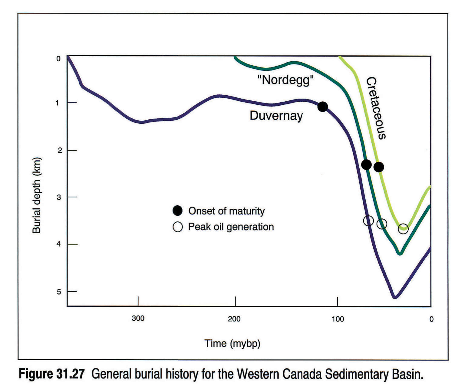
Several authors have developed burial history profiles for the Western Canada Sedimentary Basin (e.g., Deroo et al., 1977; Creaney and Allan, 1990; Issler et al., 1990). Figure 31.27 is a typical burial history profile representing most of the Western Canada Sedimentary Basin. The principle phase of oil generation was during the Late Cretaceous - Early Tertiary Laramide burial, although there may, in certain areas, have been minor oil generation prior to this time.
Summary
The Western Canada Sedimentary Basin contains at least nine active petroleum systems driven by the following source rocks:
- Ordovician - marine kukersites of the Stony Mountain, Herald, Yeoman and Winnipeg formations
- Middle Devonian - basinal marine laminites of the Keg River/Winnipegosis formations
- Upper Devonian - basinal marine laminites of the Leduc-equivalent Duvernay and Cooking Lake-equivalent Majeau Lake formations
- Upper Devonian - basinal laminites of the Cynthia Member of the Nisku Group
- Uppermost Devonian and lowermost Mississippian - the basin-wide marine mudstones of the Exshaw/Bakken formations as well as the more locally developed shales in the Lodgepole Formation
- Middle Triassic - the marine phosphatic siltstones at the base of the Doig Formation
- Lower Jurassic - the marine lime muds of the "Nordegg" Member of the Fernie Group
- Lower Cretaceous - the continental coals and carbonaceous shales of the Mannville Group
- Upper Cretaceous - the marine mudstones of the Colorado Group, principally the First and Second White Speckled Shales and the Fish Scales Zone
In general, these source rocks are thermally mature only in the more deeply buried western half of Alberta and the southeastern corner of Saskatchewan (northern rim of the Williston Basin).
The Mannville has acted as a major regional collector for oil draining from thermally mature, pre-Mannville source rocks. This has resulted in the focussing of some 1.8 trillion barrels of oil into the super-giant accumulations at Peace River, Athabasca-Wabasca, Cold Lake and Lloydminster. However, significant ingress of meteoric water at Mannville outcrop has allowed biodegradation to proceed and the oil is biodegraded to heavy bitumen. In fact only approximately 30 billion barrels (1.8 percent) of oil that was generated and migrated from the pre-Mannville section remains conventional. This confirms the supercharged, high efficiency, low impedance designation of Demaison and Huizinga (1991).
In contrast, the Colorado section, above the Joli Fou shale and its equivalents, has been isolated (with respect to oil migration) from the underlying Mannville and pre-Mannville section. The updip pinchout of Cardium and Viking sands has precluded the ingress of fresh water and therefore biodegradation is minimal in the Colorado petroleum system. Thus, of the approximately 12 billion barrels of oil in this system, 100 percent is considered to be conventional. In this respect the Colorado system would be classified as a supercharged, high efficiency, high impedance system.
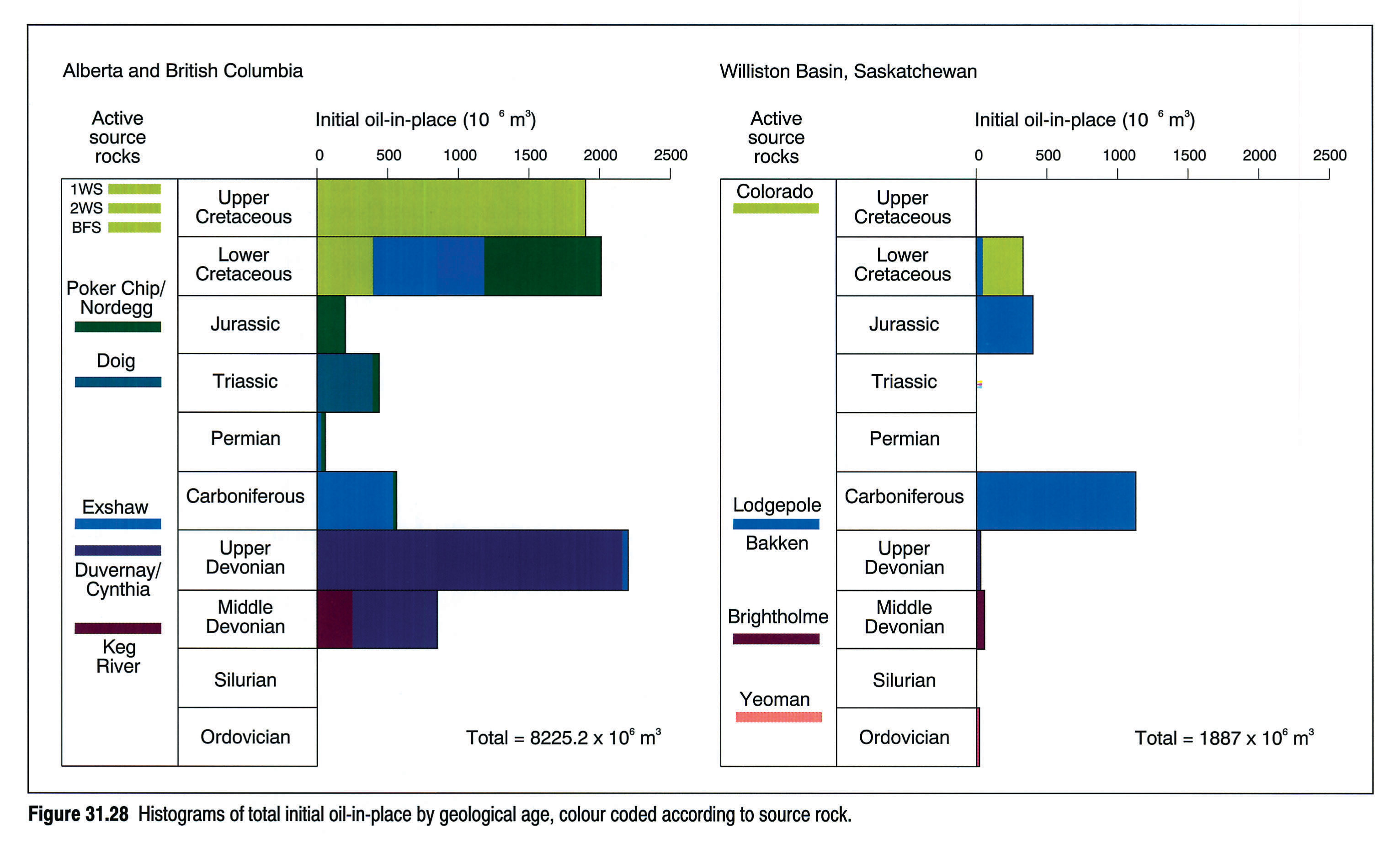
Figure 31.28 presents the same conventional reserves data shown in Figure 31.1, with colour coding according to the source rock responsible for the reserves.
Advanced maturity in the western portion of Alberta and in British Columbia is responsible for significant quantities of thermal gas generated in all petroleum systems (with the exception of the Williston Basin-confined Ordovician system). In addition, the immature eastern portion of Alberta contains significant biogenic methane in a number of reservoirs.
It should be stressed that the analyses presented here represent only a regional overview of the major petroleum systems. Local variations on this general scheme do occur, and more work should refine this overall model. Also, although the source(s) for the oil sands/bitumen/heavy oils has been resolved to the satisfaction of some of us (Creaney, Allan, Cole) the rest of us await additional evidence and documentation of source intervals in the basin before assuming an entrenched position regarding this most important oil-source correlation in the Western Canada Sedimentary Basin.
Acknowledgements
The authors would like to thank fellow staff and management at Imperial Oil Resources Limited and the Institute of Sedimentary and Petroleum Geology for encouragement and technical support during the preparation of this chapter, and for permission to publish.
References
- Allan, J. and Creaney, S. 1988. Sequence stratigraphic control of source rocks: Viking-Belly River System (Abstract). In: Sequences, Stratigraphy, Sedimentology; Surface and Subsurface. D.P. James and D.A. Leckie (eds.). Canadian Society of Petroleum Geologists, Memoir 15, p. 575.
- Allan, J. and Creaney, S. 1991. Oil families of the Western Canada Basin. Bulletin of Canadian Petroleum Geology, v. 39, p. 107-122.
- Brooks, P.W., Fowler, M.G., and Macqueen, R.W. 1988. Biological marker and conventional organic geochemistry of oil sands/heavy oils, Western Canada Basin. Organic Geochemistry, v. 12, p. 519-539.
- Brooks, P.W., Fowler, M.G., and Macqueen, R.W. 1989. Biomarker geochemistry of Cretaceous oil sands, heavy oil and Paleozoic carbonate trend bitumens, Western Canada Basin. In: Proceedings, Fourth UNITAR/UNDP International Conference on Heavy Crude and Tar Sands. R.F. Meyer and E.J. Wiggins (eds.). published by AOSTRA, Edmonton, Alberta, v. 2, Geology, Chemistry, p. 594-606.
- Brooks, P.W., Fowler, M.G., and Macqueen, R.W. 1990. Use of biomarkers, including aromatic steroids, to indicate relationships between oil sands/heavy oils/bitumens and conventional oils, Western Canada Basin. In: Proceedings, 1989 Eastern Oil Shale Symposium. D.J. Lazar (ed.). November 15-17, 1989, Lexington, Kentucky, Institute for Mining and Minerals Research, University of Kentucky, Lexington, Kentucky, p. 104-111.
- Cameron, A.R. 1972. Petrography of Kootenay coals in the Upper Elk River and Crowsnest areas, British Columbia and Alberta. Alberta Research Council, Information Series no. 60, p. 31-46.
- Chevron Exploration Staff. 1979. The geology, geophysics and significance of the Nisku reef discoveries, West Pembina area, Alberta, Canada. Bulletin of Canadian Petroleum Geology, v. 27, p. 326-359.
- Clark, J.P. and Philp, R.P. 1989. Geochemical characterization of evaporite and carbonate depositional environments and correlation of associated crude oils in the Black Creek Basin, Alberta. Bulletin of Canadian Petroleum Geology, v. 37, p. 401-416.
- Creaney, S. 1989. Reaction of organic material to geological heat. In: Thermal History of Sedimentary Basins - Methods and Case Histories. N.D. Naeser and T.H. McCulloh (eds.). Springer-Verlag, p. 37-52.
- Creaney, S. and Allan, J. 1990. Hydrocarbon generation and migration in the Western Canada Sedimentary Basin. In: Classic Petroleum Provinces. J. Brooks (ed.). Special Publication of the Geological Society, Blackwell Scientific.
- Creaney, S. and Allan, J. 1992. Petroleum systems in the foreland basin of Western Canada. In: Foreland basins and foldbelts. R.W. Macqueen and D.A. Leckie (eds.). American Association of Petroleum Geologists, Memoir 55, p. 279-308.
- Creaney, S. and Stoakes, F.A. 1987. The Exshaw Formation laminites in the Peace River Arch area: pattern of maturation and migration with exploration implications for the Wabamun Group. Abstract and talk presented at the 2nd International Symposium on the Devonian System, Calgary, 1987.
- Demaison, G. and Huizinga, B.J. 1991. Genetic classification of petroleum systems. American Association of Petroleum Geologists, Bulletin, v. 75, p. 1626-1643.
- Deroo, G., Powell, T.G., Tissot, B., and McCrossan, R.G. 1977. The origin and migration of petroleum in the Western Canadian Sedimentary Basin, Alberta: a geochemical and thermal maturation study. Geological Survey of Canada, Bulletin 262, 136 p.
- Dow, W.G. 1974. Application of oil-correlation and source rock data to exploration in Williston Basin. American Association of Petroleum Geologists, Bulletin, v. 58, p. 1253-1262.
- Du Rouchet, J. 1985. Migration in fracture networks - an alternative interpretation of the supply of the giant tar accumulations in Alberta, Canada. Part II, Journal of Petroleum Geology, v. 8, p. 107-114.
- England, T.D.J. and Bustin, R.M. 1986. Thermal maturation of the Western Sedimentary Basin south of the Red Deer River: I. Alberta Plains. Bulletin of Canadian Petroleum Geology, v. 34, p. 71-90.
- Espitalié, J. 1986. Use of Tmax as a maturation index for different types of organic matter. Comparison with vitrinite reflectance. In: Thermal Modelling in Sedimentary Basins. Exploration Research Conference Proceedings, Orléans, France, 3-7.06.85, (Éditions Technip), p. 475-496.
- Feinstein, S., Brooks, P.W., Fowler, M.G., Snowdon, L.R., and Williams, G.K. 1988. Families of oils and source rocks in the central Mackenzie Corridor: a geochemical oil-oil and oil-source rock correlation. In: Sequences, Stratigraphy, Sedimentology: Surface and Subsurface. D.P. James and D.A. Leckie (eds.). Canadian Society of Petroleum Geologists, Memoir 15, p. 543-552.
- Fowler, M.G., Abolins, P., and Douglas, A.G. 1986. Monocyclic alkanes in Ordovician organic matter. In: Advances in Organic Geochemistry 1985, Organic Geochemistry, v. 10, p. 815-823.
- Fowler, M.G., Brooks, P.B., and Macqueen, R.W., 1989. A comparison between the biomarker geochemistry of some samples from the lower Jurassic Nordegg Member and Western Canada basin oil sands and heavy oils. In: Current Research, Part D: Geological Survey of Canada, Paper 89-1D, p. 19-24.
- Fuex, A.N. 1977. The use of stable carbon isotopes in hydrocarbon exploration. Journal of Geochemical Exploration, v. 7, p. 155-188.
- Garven, G. 1989. A hydrogeologic model for the formation of giant oil sands deposits of the Western Canada Sedimentary Basin. American Journal of Science, no. 289, p. 105-166.
- Grantham, P.J. and Wakefield, L.L. 1988. Variations in the sterane carbon number distributions of marine source rock derived crude oils through geological time. Organic Geochemistry, v. 12, p. 61-73.
- Haquebard, P. 1977. Rank of coal as an index of organic metamorphism for oil and gas in Alberta. In: The Origin and Migration of Petroleum in the Western Canadian Sedimentary Basin, Alberta. Geological Survey of Canada, Bulletin 262.
- Hayes, B.J.R., Christopher, J.E., Rosenthal, L., Los, G., McKercher, B., Minkin, D.F., Tremblay, Y.M., and Fennell, J.W. (this volume). Cretaceous Mannville Group of the Western Canada Sedimentary Basin. In: Geological Atlas of the Sedimentary Basin. G.D. Mossop and I. Shetsen (comps.). Calgary, Canadian Society of Petroleum Geologists and Alberta Research Council, chpt. 19.
- Hitchon, B. 1964. Formation fluids. In: Geological History of Western Canada. R.G. McCrossan and R.P. Glaister (eds.). Alberta Society of Petroleum Geologists, Calgary, p. 201-217.
- Hitchon, B., Bachu, S., and Undershultz J.R. 1990. Regional subsurface hydrogeology, Peace River Arch area, Alberta and British Columbia. Bulletin of Canadian Petroleum Geology, v. 38A, p. 196-217.
- Issler, D.R., Beaumont, C., Willett, S.D., Donelick, R.A., Moers, J., and Grist, A. 1990. Preliminary evidence from apatite fission-track data concerning the thermal history of the Peace River Arch region, Western Canada Basin. Bulletin of Canadian Petroleum Geology, v. 38A, p. 250-269.
- Kalkreuth, W. 1982. Rank and petrographic composition of - selected Jurassic-Lower Cretaceous coals from British Columbia, Canada. Bulletin of Canadian Petroleum Geology, v. 30, p. 112-139.
- Kalkreuth, W. and McMechan, M. 1988. Burial history and thermal maturity, Rocky Mountain Front Ranges, foothills and foreland, east-central British Columbia and adjacent Alberta, Canada. American Association of Petroleum Geologists, Bulletin, v. 72, p. 1395-1410.
- Karst, R.H. and White, G.V. 1980. Coal rank distribution within the Bluesky-Gething stratigraphic horizon of northeastern British Columbia. British Columbia Department of Mines and Petroleum Reserves, Paper 1980-1, Geologic Fieldwork.
- Krouse, H.R., Viau, C.A., Eliuk, L.S., Ueda, A., and Halas, S. 1989. Chemical and isotopic evidence of thermochemical sulphate reduction by light hydrocarbon gases in deep carbonate reservoirs. Nature, v. 333, p. 415-419.
- Leckie, D.A., C. Singh, Goodarzi F., and Wall J.W. 1990. Organic-rich, radioactive marine shale: A case study of a shallow-water condensed section, Cretaceous Shaftesbury Formation, Alberta, Canada. Journal of Sedimentary Petrology, v. 60, p. 101-117.
- Leenheer, M.J. 1984. Mississippian Bakken and equivalent formations as source rocks in the Western Canadian Basin. Organic Geochemistry, v. 6, p. 521-532.
- Leenheer, M.J. and Zumberge, J.E. 1987. Correlation and thermal maturity of Williston Basin crude oils and Bakken source rocks using terpane biomarkers. In: Williston Basin: Anatomy of a Cratonic Oil Province. M.W. Longman (ed.). Rocky Mountain Association of Geologists, Denver, Colorado, U.S.A., p. 287-298.
- Macauley, G. 1984a. Cretaceous oil shale potential of the prairie provinces, Canada. Geological Survey of Canada, Open File Report OF-977, 61 p.
- Macauley, G. 1984b. Cretaceous oil shale potential in Saskatchewan. In: Oil and Gas in Saskatchewan 1984, p. 255-269.
- Macauley, G., Snowdon, L.R., and Ball, F.D. 1985. Geochemistry and geological factors governing exploitation of selected - Canadian oil shale deposits. Geological Survey of Canada, Paper 85-13, 64 p.
- Macauley, G., Fowler, M.G., Goodarzi, F., Snowdon, L.R., and Stasiuk, L.D. 1990. Ordovician oil shale - source rock sediments in the central and eastern Canada Mainland and eastern Arctic areas, and their significance for frontier exploration. Geological Survey of Canada Paper 90-14, 51 p.
- Magoon, L.B. 1988. The petroleum system - a classification scheme for research, exploration, and resource assessment. In: Petroleum Systems of the United States. L.B. Magoon (ed.). United States Geological Survey, Bulletin 1870.
- Masters, J. 1979. Deep Basin gas trap in Western Canada. American Association of Petroleum Geologists, Bulletin, v. 63, p. 152-181.
- McCrossan, R.G. and Glaister, R.P. (eds.) 1964. Geological History of Western Canada. Alberta Society of Petroleum Geologists, Calgary.
- Milner, C.W.D., Rogers, M.A., and Evans, C.R. 1977. Petroleum transformations in reservoirs, Journal of Geochemical Exploration, v. 7, p. 101-153.
- Moshier, S.O. and Waples, D.W. 1985. Quantitative evaluation of Lower Cretaceous Mannville Group as source rock for Alberta's oil sands. American Association of Petroleum Geologists, Bulletin, v. 69, p. 161-172.
- Norford, B.S., Haidl, F.M., Bezys, R.K., Cecile, M.P., McCabe, H.R., and Paterson, D.F. (this volume). Middle Ordovician to Lower Devonian strata of the Western Canada Sedimentary Basin. In: Geological Atlas of the Western Canada Sedimentary Basin. G.D. Mossop and I. Shetsen (comps.). Calgary, Canadian Society of Petroleum Geologists and Alberta Research Council, chpt. 9.
- Osadetz, K.G., Goodarzi, F., Snowdon, L.R., Brooks, P.W., and Fayerman, S. 1990. Winnipegosis pinnacle reef play in Williston Basin: Oil compositions and effects of oil-based drilling muds on exploration geochemistry. In: Current Research, Part D, Geological Survey of Canada, Paper 90-1D, p. 153-163.
- Osadetz, K.G. and Haidl, F.M. 1989. Tippecanoe sequence: Middle Ordovician to lowest Devonian: vestiges of a great epeiric sea. In: Chapter 8, Western Canada Sedimentary Basin: A Case Study. B.D. Ricketts (ed.). Special Publication n. 30, Canadian Society of Petroleum Geologists, Calgary, p. 121-137.
- Osadetz, K.G. and Snowdon, L.R. (in press). Significant Paleozoic petroleum source rocks, their distribution, richness and thermal maturity in Canadian Williston Basin (southeastern Saskatchewan and southwestern Manitoba). Geological Survey of Canada, Bulletin.
- Osadetz, K.G., Snowdon, L.R., and Brooks, P.W. 1991. Relationships amongst oil quality, thermal maturity and post-accumulation alteration in Canadian Williston Basin (southeastern Saskatchewan and southwestern Manitoba). In: Proceedings of the 6th International Williston Basin Symposium. J.E. Christopher and F. Haidl (eds.). Special Publication no. 11, Saskatchewan Geological Society, p. 293-311.
- Osadetz, K.G., Snowdon L.R., and Stasiuk, L.D. 1989. Association of enhanced hydrocarbon generation and crustal structure in the Canadian Williston Basin. In: Current Research, Part D, Geological Survey of Canada Paper 89-1D, p. 35-47.
- Passey, Q.R., Creaney, S., Kulla, J.D., Moretti, F., and Stroud, J.D. 1989. Well log evaluation of organic rich tocks (Abstract). European Association of Organic Geochemists, Annual Meeting, Paris, Sept. 1989.
- Passey, Q.R., Creaney, S., Kulla, J.D., Moretti, F., and Stroud, J.D. 1990. A practical model for organic richness from porosity and resistivity logs. American Association of Petroleum Geologists, Bulletin, v. 74, p. 1777-1794.
- Piggot, N. and Lines, M.D. 1990. A case study of migration from the West Canada Basin. (Abstract). Conference on Petroleum Migration, London, 1990.
- Plint, A.G., Walker, R.G., and Bergman, K.M. 1986. Cardium Formation 6: Stratigraphic framework of the Cardium in sub- surface. Bulletin of Canadian Petroleum Geology, v. 34, p. 213-225.
- Potter, D. and St. Onge, A. 1991. Minton Pool, south-central Saskatchewan: a model for basement-induced structural and stratigraphic relationships. In: Proceedings of the 6th Inter- national Williston Basin Symposium. J.E. Christopher and F. Haidl (eds.). Special Publication no. 11, Saskatchewan Geological Society, p. 21-33.
- Poulton, T.P., Tittemore, J., and Dolby, G. 1990. Jurassic strata of northwestern (and west-central) Alberta and northeastern British Columbia. Bulletin of Canadian Petroleum Geology, v. 38A, p. 159-175.
- Poulton, T.P., Christopher, J.E., Hayes, B.J.R., Losert, J., Tittemore, J., and Gilchrist, R.D. (this volume). Jurassic and lowermost Cretaceous strata of the Western Canada Sedimentary Basin. In: Geological Atlas of the Western Canada Sedimentary Basin. G.D. Mossop and I. Shetsen (comps.). Calgary, Canadian Society of Petroleum Geologists and Alberta Research Council, chpt. 18.
- Powell, T.G. 1984. Some aspects of the hydrocarbon geochemistry of a Middle Devonian barrier-reef complex, Western Canada. In: Petroleum Geochemistry and Source Rock Potential of Carbonate Rocks. J.G. Palacas (ed.). American Association of Petroleum Geologists, Studies in Geology no. 18, p. 45-61.
- Price, L.C., Ging, T., Daws, T., Love, A., Pawlewicz, M., and Anders, D., 1984. Organic metamorphism in the Mississippian-Devonian Bakken shale, North Dakota portion of the Williston Basin. In: Hydrocarbon Source Rocks of the Greater Rocky Mountain Region, J. Woodward, F.F. Meissner and J.L. Clayton (eds.). Denver: Rocky Mountain Association of Geologists, p. 83-134.
- Richards, B.C., Barclay, J.E., Bryan, D., Hartling, A., Henderson, C.M., Hinds, R.C. and Trollope, F.H. (this volume). Carboniferous strata of the Western Canada Sedimentary Basin. In: Geological Atlas of the Western Canada Sedimentary Basin. G.D. Mossop and I. Shetsen (comps.). Calgary, Canadian Society of Petroleum Geologists and Alberta Research Council, chpt. 14.
- Riediger, C.L. 1990. Rock-Eval/TOC data from the Lower Jurassic "Nordegg Member", and the Lower and Middle Triassic Doig and Montney formations, Western Canada Sedimentary Basin, Alberta and British Columbia. Geological Survey of Canada, Open File Report 2308.
- Riediger, C.L. 1991. Lower Mesozoic hydrocarbon source rocks, Western Canada Sedimentary Basin. Unpublished PhD thesis, University of Waterloo.
- Riediger, C.L., Brooks, P.W., Fowler, M.G., and Snowdon, L.R. 1990a. Lower and Middle Triassic source rocks, thermal maturation, and oil-source correlation in the Peace River Embayment area, Alberta and British Columbia. Bulletin of Canadian Petroleum Geology, v. 38A, p. 218-235.
- Riediger, C.L., Brooks, P.W., Fowler, M.G., and Snowdon, L.R. 1990b. Source rock analysis of the Lower Jurassic "Nordegg Member" and oil-source correlations, northwestern Alberta and northeastern British Columbia. Bulletin of Canadian Petroleum Geology, v. 38A, p. 236-249.
- Riediger, C.L., Fowler, M.G., Brooks, P.W., and Snowdon, L.R. 1989. Triassic oils and potential Mesozoic source rocks, Peace River Arch area, Western Canada Basin. Advances in Organic Geochemistry 1989, Organic Geochemistry, v. 16, p. 295-305.
- Rosenthal, L.R. 1987. The Winnipegosis Formation of the northeastern margin of the Williston Basin. In: Proceedings of the Fifth International Williston Basin Symposium. C.G. Carlson and J.E. Christopher (eds.). Saskatchewan Geological Society, Special Publication no. 9, p. 37-46.
- Stasiuk, L.D. and Osadetz, K.G. 1990. Progress in the life cycle and phyletic affinity of Gloeocapsomorpha Prisca Zalessky 1917 from Ordovician rocks in Canadian Williston Basin. In: Current Research, Part D, Geological Survey of Canada, Paper 90-ID, p. 127-137.
- Stoakes, F.A. 1980. Nature and control of shale basin fill and its effect on reef growth and termination: Upper Devonian Duvernay and Ireton formations of Alberta, Canada. Bulletin of Canadian Petroleum Geology, v. 28, p. 345-410.
- Stoakes, F.A. and Creaney, S. 1984. Sedimentology of a carbonate source rock: Duvernay Formation of central Alberta. In: Carbonates in Subsurface and Outcrop. L. Eliuk (ed.). Proceedings of the 1984 Canadian Society of Petroleum Geologists Core Conference, Calgary, p. 132-147.
- Stoakes, F.A. and Creaney, S. 1985. Controls on the accumulation and subsequent maturation and migration history of a carbonate source rock. Society of Economic Paleontologists and Mineralogists, Core Workshop Proceedings, Golden, Colorado, U.S.A., August 1985.
- Stronach, N.J. 1984. Depositional environments and cycles in the Jurassic Fernie Formation, southern Canadian Rocky Mountains. In: The Mesozoic of Middle North America. D.F. Stott and D.J. Glass (eds.). Canadian Society of Petroleum Geologists, Memoir 9, p. 43-67.
- Switzer, S.B., Holland, W.G., Christie, D.S., Graf, G.C., Hedinger, A., McAuley, R., Wierzbicki, R., and Packard, J.J. (this volume). Devonian Woodbend-Winterburn strata of the Western Canada Sedimentary Basin. In: Geological Atlas of the Western Canada Sedimentary Basin. G.D. Mossop and I. Shetsen (comps.). Calgary, Canadian Society of Petroleum Geologists and Alberta Research Council, chpt. 12.
- Tilley, B.J., Nesbitt, B.E., and Longstaffe, F.J. 1989. Thermal history of Alberta Deep Basin: comparative study of fluid inclusion and vitrinite reflectance data. American Association of Petroleum Geologists, Bulletin, v. 73, p. 1206-1222.
- Tissot, B.P. and Welte, D.H. 1984. Petroleum formation and occurrence (Second Edition). Springer-Verlag, 699 p.
- Walker, R.G. 1988. The origin and scale of sequence and erosional bounding surfaces in the Cardium Formation. In: Sequences, Stratigraphy and Sedimentology; Surface and Subsurface. D.P. James and D.A. Leckie (eds.). Canadian Society of Petroleum Geologists, Memoir 15, p. 573-574.
- Webster, R.L. 1984. Petroleum source rocks and stratigraphy of the Bakken Formation in North Dakota. In: Hydrocarbon Source Rocks of the Greater Rocky Mountain Region. J. Woodward, F.F. Meissner and J.L. Clayton (eds.). Rocky Mountain Association of Geologists, Denver.
- Welte, D.H., Schaefer, R.G., Stoessinger, W., and Radke, M. 1984. Gas generation and migration in the Deep Basin of Western Canada. In: Elmworth - Case Study of a Deep Basin Gas Field. J.A. Masters (ed.). American Association of Petroleum Geologists, Memoir 38, p. 35-47.
- Williams, J.A. 1974. Characterization of oil types in Williston Basin. American Association of Petroleum Geologists, Bulletin, v. 58, p. 1243-1252.
- Zumberge, J.E. 1983. Tricyclic diterpane distributions in the correlation of Paleozoic crude oils from the Williston Basin. In: Advances in Organic Geochemistry 1981, John Wiley & Sons Ltd., p. 738-745.