Chapter 4 - Potential Fields and Basement Structure - Western Canada Sedimentary Basin |
|
| Chapter Sections | Download |
Authors:
G.M. Ross - Geological Survey of Canada, Calgary
J. Broome - Geological Survey of Canada, Ottawa
W. Miles - Geological Survey of Canada, Ottawa
Introduction
The Western Canada Sedimentary Basin (WCSB) rests on a foundation of continental crust and lithospheric mantle that makes up the buried extension of the Precambrian Canadian Shield. Geophysical data permit indirect examination of this lithosphere from two different perspectives. The first pertains to upper crustal (less than 15 km) structure and utilizes potential field data (aeromagnetic and gravity anomaly maps) to trace into the subsurface the variations in crustal structure that are apparent in the exposed shield. The second perspective pertains to the long-wavelength structure of the crust and mantle (filtered subsets of potential field data and deep seismic refraction and reflection studies) and hence addresses possible causitive mechanisms associated with basin formation and subsidence patterns. However, distinguishing Precambrian lithospheric features from those acquired during Phanerozoic basin formation is problematical (see Stephenson et al. 1989, and Ross, 1990).
The purpose of this chapter is to provide a brief overview of potential field data and their interpretation in the Western Canada Sedimentary Basin. More detailed discussions may be found in Ross et al. (1991; in press), Villeneuve et al. (1993) and Ross and Stephenson (1989). For a discussion of seismic refraction/reflection studies and electromagnetic-magnetotelluric studies the reader is referred to summary papers by Ross and Stephenson (1989), Sweeney et al. (1991) and Jones and Craven (1990), respectively.
A short review of the tectonic history of the exposed shield adjacent to the edge of the Phanerozoic strata precedes the presentation of potential field data and is intended to provide a context for the interpretation and inferred continuation of shield elements into the subsurface. An appreciation of the tectonic fabric and evolution of the shield is relevant to subsequent chapters that examine the sedimentary sequence. In particular, the degree to which basement structures may have controlled anomalous sedimentation, diagenetic and structural patterns in both the Western Canada Sedimentary Basin and the adjacent Cordillera is controversial.
As this Atlas goes to press, LITHOPROBE is embarking on a five-year program to examine the deep crustal structure of Alberta and its influence on the evolution of the sedimentary units. These studies may provide much-needed constraints on the role of basement structure in the evolution of the Western Canada Sedimentary Basin.
Tectonic Evolution of the Canadian Shield
For the following discussion, readers are referred to the tectonic assemblage map shown in Figure 4.1. It should be emphasized that the illustrated domains in the exposed Canadian Shield are generalized at this scale (1:10 000 000) and that the domains beneath the Phanerozoic cover of the Western Canada Sedimentary Basin are, if anything, even more generalized and interpretive in nature.
Recent work by Paul Hoffman has led to a synthesis of field relations and U-Pb geochronology into a coherent tectonic framework for the Precambrian evolution of Laurentia and the Canadian Shield (Hoffman, 1987; 1988; 1989). This work recognizes the importance of accretionary and collisional processes, operative during the interval 2.0 - 1.8 Ga, in the assembly of the Canadian Shield. Early Proterozoic orogenic belts in Western Canada include Wopmay Orogen (1.97-1.84 Ga), Thelon-Taltson Orogen (2.0-1.9 Ga) and Trans-Hudson Orogen (1.88-1.79 Ga). These are characterized by deformed and metamorphosed trailing (passive) margin and foreland basin sedimentary sequences, accreted terranes of island arc affinity and, significantly, continental margin magmatic arcs of calc-alkaline affinity. The latter elements provide distinct aeromagnetic signatures that allow each of these orogens to be traced beneath the Phanerozoic sedimentary cover
The Proterozoic orogens weld older Archean rocks of the Superior Province to the southeast Churchill (Hearne) Province, and Archean Slave Province rocks to the northwest Churchill (Rae) Province. Wopmay Orogen forms the weld between Proterozoic crust (1.97 Ga) of Hottah Terrane and Slave Province, similar to Proterozoic (2.32-1.99 Ga) crustal slivers in northern Alberta that have been accreted to the Rae Province along the Taltson Orogen (Ross et al., 1991).
Several of the major structural discontinuities that formed during collisional assembly of the shield can be traced clearly into the subsurface. The Great Slave Lake Shear Zone is a broad band of mylonite south of Great Slave Lake that formed during the northeastward translation of Slave Province relative to Rae Province between 2.0 and 1.9 Ga (Hanmer, 1988). This structure continues farther west where it coincides with the Hay River Fault in the subsurface of northeast British Columbia (Lavoie, 1958). The Snowbird Tectonic Zone is a pronounced aeromagnetic and gravity discontinuity that separates the Rae and Hearne provinces (formerly Churchill Province) and can be traced from Hudson Bay, across the shield and through Alberta as far west as the foothills. Although dramatic in its potential field expression and presence of mylonitic rocks, the timing, kinematics and tectonic significance of this structure are still uncertain. The Thompson Belt (Churchill-Superior Boundary Zone) is the boundary zone between the Archean Superior Province and the Lower Proterozoic Trans-Hudson Orogen. It is a composite belt of north-trending curvilinear aeromagnetic and gravity anomalies that truncates the east-trending potential field fabric characteristic of the Superior Province. The distinctive gravity gradient allows this structural break, and hence the edge of the Superior Province, to be traced south to the United States border (Green et al., 1985). The potential field expression of structures described above, particularly the truncation of geophysical fabrics, forms the basis for the interpretation of similar structures that are entirely buried, such as the Vulcan Low in southern Alberta.
Aeromagnetic Anomalies
The aeromagnetic anomaly map (Fig. 4.2) is plotted from a digital database (residuals after subtraction of Geomagnetic Reference Field), derived from a variety of sources. Derivatives of the total-field data set have been published by Dods et al. (1989). Data over the exposed Canadian Shield were acquired by the Geological Survey of Canada through contract surveys flown at an average terrain clearance of 305 m and a line spacing of 800 m. Data in the Interior Plains were acquired largely through donations from petroleum companies on surveys that were, for the most part, flown between 1956 and 1966; details of the line spacing, line elevation and survey company commonly are unknown. The data were digitized from donated maps rather than from survey analog tape records.
Recently, contracted surveys by Commonwealth Geophysical Ltd. and surveys by the Geological Survey of Canada, the latter between 52° and 54°N in Alberta, have used better navigational techniques (Global Positioning System), magnetometers with improved sensitivity, and better quality control through monitoring of flight path and diurnal variations in the magnetic field, to produce excellent and very precise data sets. Regions of Saskatchewan, Manitoba and parts of southern Alberta remain to be covered but likely will be flown over the next few years. For the compilation of inferred basement domains shown in Figure 4.1, access to proprietary data was granted by Petro-Canada Ltd.
The aeromagnetic anomaly map in this Atlas was produced from data interpolated onto a 2 km grid. The use of artificial illumination to produce shaded relief (Dods et al. 1985; Broome, 1990) can dramatically improve the visibility of certain features, depending on the orientation of structures with respect to the angle of illumination. For Figure 4.2, we used an artificial illumination source from the southeast to emphasize the predominant northerly and northeasterly-trending structure of the region.
At the scale of the Atlas compilation, sedimentary rocks of the Western Canada Sedimentary Basin have a damping effect that reflects the attenuation of high-frequency aeromagnetic components as a consequence of increased depth to the source. The aeromagnetic anomalies are interpreted as being sourced largely in basement rather than within the sedimentary section. This interpretation is supported by the similarity between wave number distribution of aeromagnetic data over the basin and data over the exposed shield that have been upward continued, effectively removing near-surface high-frequency components (Teskey et al. 1989). In addition, the smooth form of sediment isopachs in the Western Canada Sedimentary Basin (Wright et al., this volume, Chapter 3) suggests that signal variation as a consequence of variable depth to basement is negligible (Cordell and Grauch, 1985) although, as suggested by Burwash et al. (this volume, Chapter 5), this may be a smoothing artifact introduced by the isopaching process. Intrasedimentary anomalies may be present but recognition is difficult given the density and acquisition elevation of aeromagnetic observations. Hydrocarbon-related magnetization, produced during the transformation of hematite to magnetite and/or pyrrhotite during fluid migration, is an intriguing concept that is being explored by the hydrocarbon industry (Machel and Burton, 1991) but the magnitude of the anomalies is below detection limits at the scale of the present compilation.
Early studies of aeromagnetic data, although limited by the unavailability of public domain data, traced aeromagnetic domains of the shield into the subsurface as far west as the Cordillera (Garland and Burwash, 1959; Coles et al., 1976). Recent interpretations of modern aeromagnetic data have built on the early studies and formed the basis for the subdivision of the basement via extrapolation of exposed domains of the Canadian Shield and by using the shield to calibrate interpretation of subsurface anomalies (Ross et al., 1991; in press).
As in the shield, discrete domains are recognized by their intensity and textural characteristics, and relations to adjacent domains (Fig. 4.2). These subdivisions can be modified by examining gravity anomaly data (Fig. 4.3) and filtered subsets (Fig. 4.4). Subdivisions based on the interpretations of potential field data are "ground truthed" by U-Pb geochronology and Sm-Nd isotope geochemistry, taking advantage of the extensive collection of basement drill core and cuttings recovered during hydrocarbon tests (Burwash, 1957; Burwash et al., 1962; Burwash et al., this volume, Chapter 5; Collerson et al., 1988; Ross et al., 1989, 1991, in press; Theriault and Ross, 1991; Villeneuve et al., 1991, 1993).
The aeromagnetic expression of known lithotectonic domains in the Canadian Shield provides a means of calibrating the interpretation and subdivision of subsurface aeromagnetic anomalies inferred to be caused by basement sources. Although this approach is simplistic, it is justified because many structures and domains can be traced from outcrop into the subsurface (with the exception of west-central and southern Alberta). Examination of aeromagnetic anomalies in the Canadian Shield suggests that, to a first-order approximation, lithology controls the aeromagnetic signal, with uncertain contributions from remanent magnetization and dipole effects.
Aeromagnetic data for the exposed Canadian Shield are dominated by remarkable high-amplitude curvilinear positive aeromagnetic anomalies that are among the most striking features of the aeromagnetic anomaly map (Fig. 4.2). These anomalies correspond to Proterozoic magmatic rocks of the Great Bear Batholith, Wathaman-Chipewyan Batholith and Thelon-Talston Magmatic Belt, which form the magmatic welds between formerly separate crustal fragments (Hoffman, 1989). The magnitude of the aeromagnetic field (up to 400 nT) is a direct reflection of the petrological properties of these rocks; that is, they are dominantly calc-alkaline magmatic rocks characterized by magnetite as the chief opaque accessory (Hoffman and McGlynn, 1977; Henderson et al., 1987), similar to magnetite series plutons in Mesozoic magmatic belts (Gastil et al., 1990). Major aeromagnetic highs in the subsurface are interpreted as magmatic belts. In some of these areas, limited drill-core data confirm the magmatic affinities, whereas in other areas (notably Eyehill High in eastern Alberta) a high-grade metamorphic origin is suggested.
The interpretation of regionally extensive negative aeromagnetic anomalies can be ambiguous. For example, depending on the ratio of induced to remanent magnetism, even magnetite-bearing rocks can produce a negative aeromagnetic signal. In some cases, negative aeromagnetic anomalies in the shield correspond to regions underlain by peraluminous plutonic rocks. A substantial part of the Taltson Belt contains a region of negative aeromagnetic character that is underlain by the Konth syenogranite (Bostock, 1987), a peraluminous (ilmenite series) batholith characterized by magmatic garnet, cordierite, muscovite and sillimanite that continues into the subsurface. The main opaque phase in rocks of this composition is ilmenite, which is antiferrimagnetic in comparison with magnetite and is the likely cause of the negative aeromagnetic signal (Strangway, 1970; Gastil et al., 1990). Regional metamorphism, which produces phase changes that transform Fe-oxides into Fe-silicates and/or oxidation of magnetite to hematite, may also account for regional aeromagnetic lows (Robinson et al., 1985). The transformation of strongly ferrimagnetic Fe-oxides into antiferrimagnetic Fe-silicates and/or hematite also occurs in shear zones as a consequence of hydration and metamorphism during deformation (Watanabe, 1966). Examples of this are seen in the Great Slave Lake Shear Zone and may account for the narrow aeromagnetic lows that contribute to the striated fabric typical of deformed magmatic rocks in the Taltson Belt. Loss of magnetization during shearing is proposed here as an interpretation of prominent curvilinear aeromagnetic lows such as the Thorsby, Vulcan and Kiskatinaw lows in the subsurface of Western Canada.
Major aeromagnetic highs in the subsurface are interpreted as magmatic belts, such as the extension of known magmatic rocks of the Wathaman, Taltson and Great Bear Batholith, with more tentative interpretations of similar aeromagnetic domains for which there is no outcrop control (Rimbey, Buffalo Head, Ksituan, Fort Simpson and possibly parts of the Hearne Province in southern Alberta). In some of these areas, limited drill-core data confirm the magmatic affinities, whereas in other areas (notably Eyehill High in eastern Alberta) a high-grade metamorphic origin is suggested. The Wathaman Batholith corresponds to a well-defined magnetic high in the Canadian Shield. However the Wathaman narrows toward the south, even though the width of the aeromagnetic anomaly does not change. This could reflect the presence of magnetite in the high-grade metasediments (Wollaston Group) to the west, or westward underthrusting of the Wathaman beneath the Wollaston Group and the Hearne Province. Also of interest is the finely striated magnetic fabric observed over the Lacombe Domain, suggesting the presence of deformed rocks, and the pronounced subcircular positive anomaly at the northeast end of the domain, which may correspond to the Willingdon volcanic centre inferred by Garland and Burwash (1959) on the basis of drill-core data. In the Hearne Province in Alberta, small, subcircular positive anomalies are reminiscent of the patterns of plutons seen in the eastern Cordillera and may suggest the presence of relatively undeformed plutons, possibly part of the circa 1760 Ma anorogenic suite in southwestern Saskatchewan (Collerson et al., 1988).
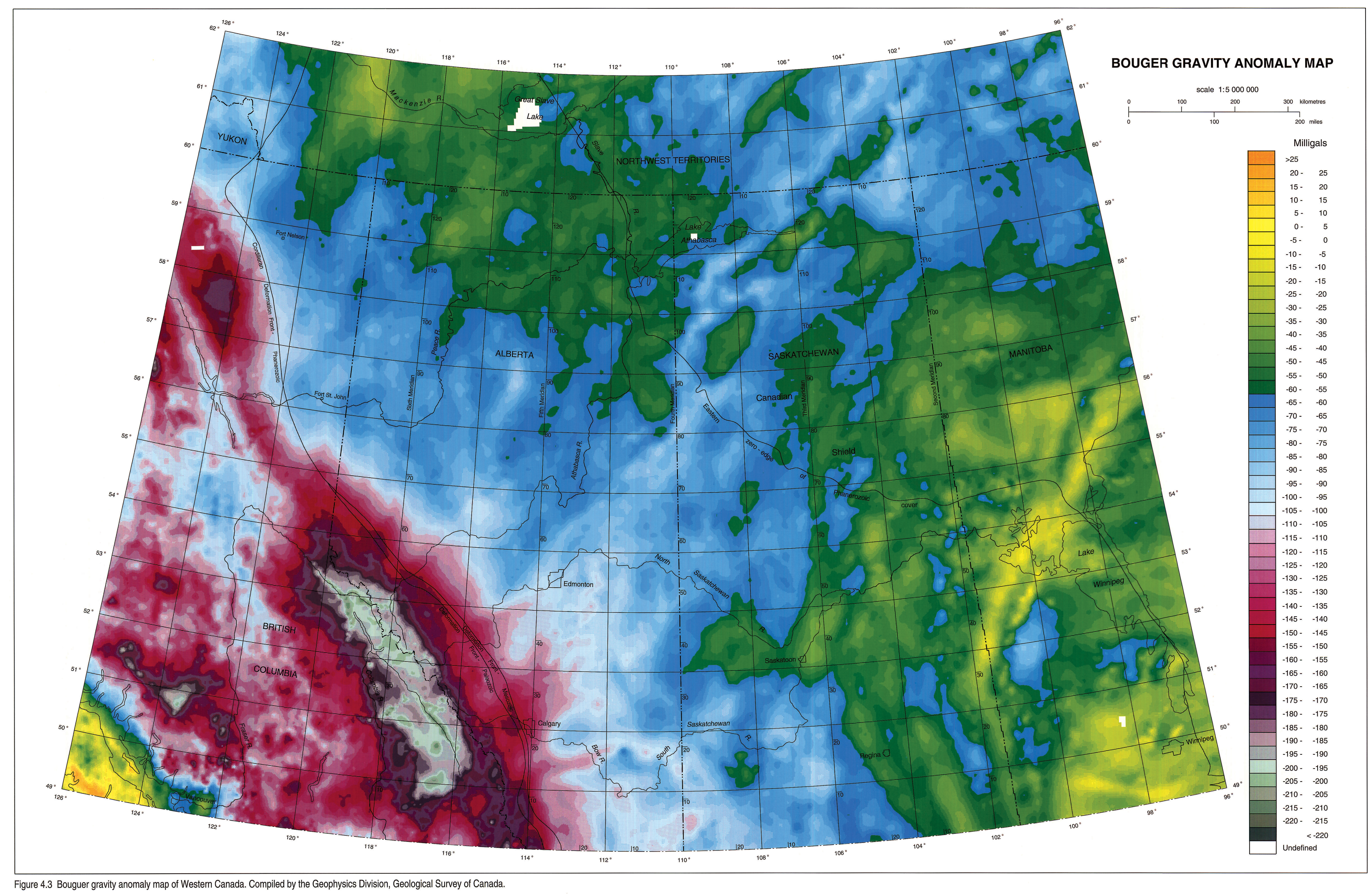
Gravity Anomaly Data
The Bouguer gravity anomaly map was constructed using data obtained from the National Geophysical Data Centre. The spacing of observations in the study area ranges from 6 to 13 km, with an average spacing of 8 km throughout much of the prairie provinces. Gravity data have had a terrain correction applied, with sea level used as a datum, and have been interpolated onto a 4 km grid, offering a reasonable compromise between detail permitted by the data and artifacts introduced by the interpolation procedure.
The Bouguer anomaly map (Fig. 4.3) is dominated by the long-wavelength contribution to background gravity values associated with crustal thickening in the Cordilleran Orogen and the presence of high heat-flow in the southern Omineca Belt of the Cordillera (Goodacre, 1972; Sweeney et al., 1991). Additional contributions may arise from variations in the thickness of continental crust and the thermal structure of the lithosphere (Stephenson et al., 1989; Ross and Stephenson, 1989; Pilkington, 1991) as well as a westward increase in sediment thickness. The strong regional gradient caused by these effects diminishes the visibility of fine detail in the gravity field related to upper crustal and shallow basement structure beneath the Western Canada Sedimentary Basin, although several dramatic features are present. Both the Snowbird Tectonic Zone and the Vulcan Low in Alberta clearly are visible in the Bouguer gravity map. The gravity break associated with the Snowbird Zone has been known for some time and was originally referred to as the Fond du Lac gravity low (Walcott, 1968) or the Kasba-Edmonton gravity low (Burwash and Culbert, 1976). The gravity signal associated with the Vulcan (aeromagnetic) Low is also a strong low and was originally interpreted as evidence for the presence of low-density Precambrian sedimentary rocks of the southern Alberta aulacogen (Kanasewich et al., 1969). However, an alternative interpretation is that it is largely an "edge" effect related to the juxtaposition of distinct crustal blocks (Gibb and Thomas, 1976; Gibb et al., 1983).
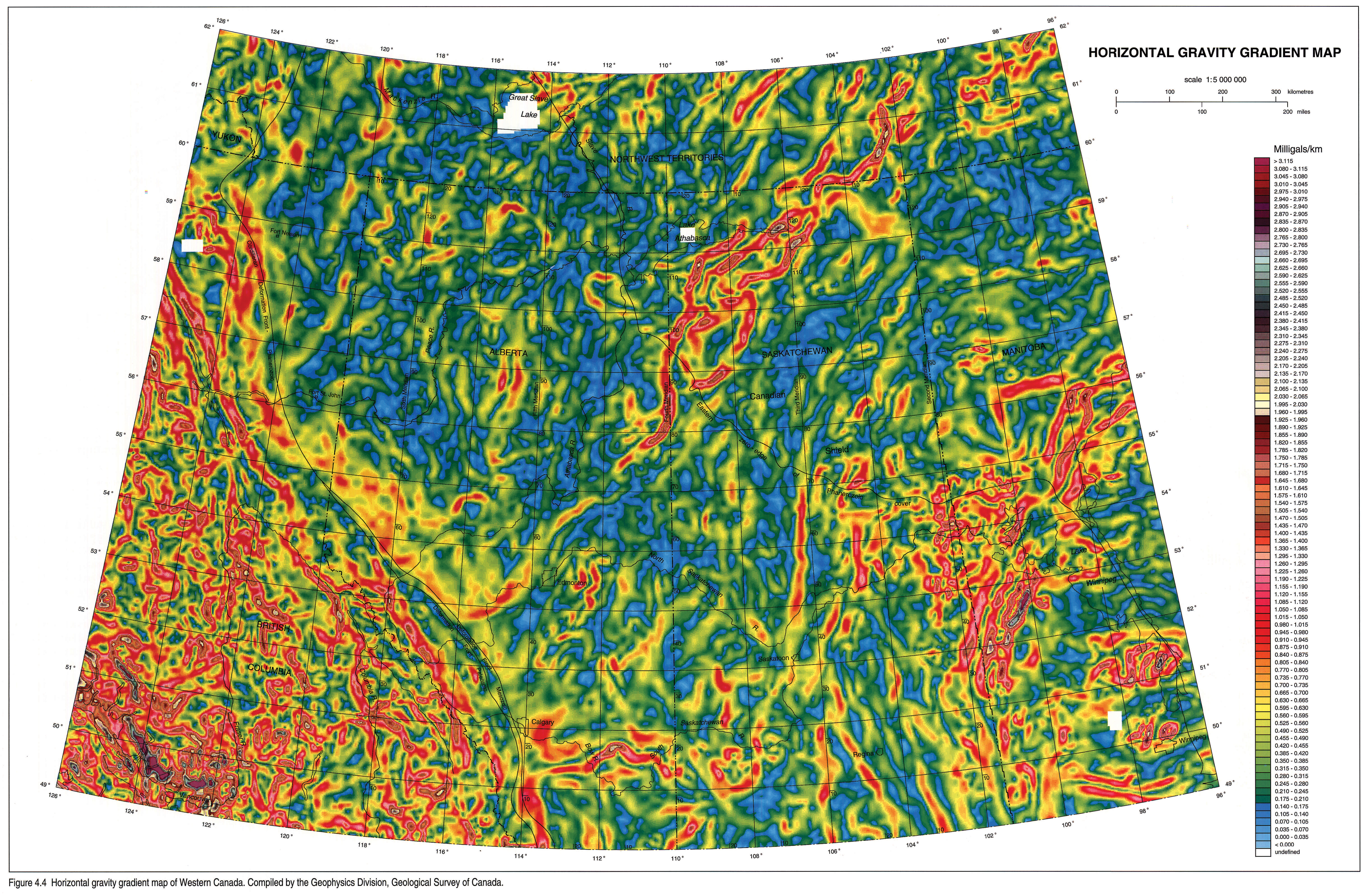
In order to remove the relatively long-wavelength contributions from Cordilleran sources, a derivative version of the Bouguer field, a horizontal gravity gradient map (Sharpton et al., 1987) is presented (Fig. 4.4). This depiction tends to accentuate the gravity anomalies and, by inference, density structure of the upper (approximately) 15 km of crust. The use of horizontal gravity gradients is an excellent indicator of the domainal structure of the upper crust, although it is not without its shortcomings. The presence of a gravity gradient reflects the juxtaposition of crustal bodies of contrasting density and/or thickness, similar to the paired positive-negative gravity anomalies recognized along Precambrian sutures by Gibb and Thomas (1976). However, in the Canadian Shield there are examples where fundamental crustal breaks, recognized on the basis of shear zones that separate rocks of dramatically different ages, are not associated with a gravity gradient. The Great Slave Lake Shear Zone, for example, is a major transcurrent shear zone that accommodated the northeast translation of the Slave Craton during its collision with the Rae Province (Gibb, 1978; Hoffman, 1987; Hanmer, 1988) yet there is no associated gravity gradient, reflecting the similarity in density and thickness between rocks on either side of this discontinuity.
The horizontal gravity gradient data (Fig. 4.4) clearly illustrate the juxtaposition of contrasting crustal domains and can be used to characterize regions on the basis of their gravity signature. The Snowbird Tectonic Zone, and its inferred extension into Alberta, forms one of the most dramatic gradients on the entire map and continues from the frontal thrust of the Rockies northeastward to Hudson Bay. The Superior Province is characterized by an east-trending fabric that is truncated within the Thompson Belt by the north-trending fabric typical of the Trans-Hudson Orogen, similar to the patterns seen in outcrop and on the aeromagnetic anomaly map. The Hearne Province is characterized by an indistinct pattern of short linear segments; the Vulcan Low stands out as a persistent discontinuity within this pattern.
In several areas of the horizontal gravity gradient map there are short linear gradient anomalies that are oriented at a high angle to the predominant aeromagnetic trend. In some cases these may represent intrasedimentary features, perhaps reflecting zones of salt dissolution or the presence of reef build-ups (possibly in the Lacombe Domain). However, similar anomalies are present over the exposed shield, such as the Taltson Belt in northeastern Alberta, suggesting that they may be a feature of the basement. Additionally, these may be an artifact introduced by inadequate density of gravity stations.
Long-wavelength Gravity Structure
Properties of the crust and lithospheric mantle such as variations in thickness, thermal structure, and average density are reflected in the long-wavelength components of the gravity anomaly data, although recognition of specific causes is subject to considerable ambiguity. Additional insights are provided by deep seismic studies, which thus far have been limited to refraction investigations (see review in Ross and Stephenson, 1989) and some deep reflection studies (Kanasewich et al., 1969; Zelt and Ellis, 1989). Wavelength-filtered gravity data can provide insight into causitive mechanisms of basin formation, given that their wavelengths approximate the wavelengths of the basin. However, major uncertainties that should be considered are the depths of the sources of the anomalies, which are difficult to determine with the available data, and the age of the anomalies. In other words, are the observed anomalies related to features of basin formation or are they inherited from the processes of crust formation and continental assembly in the Precambrian?
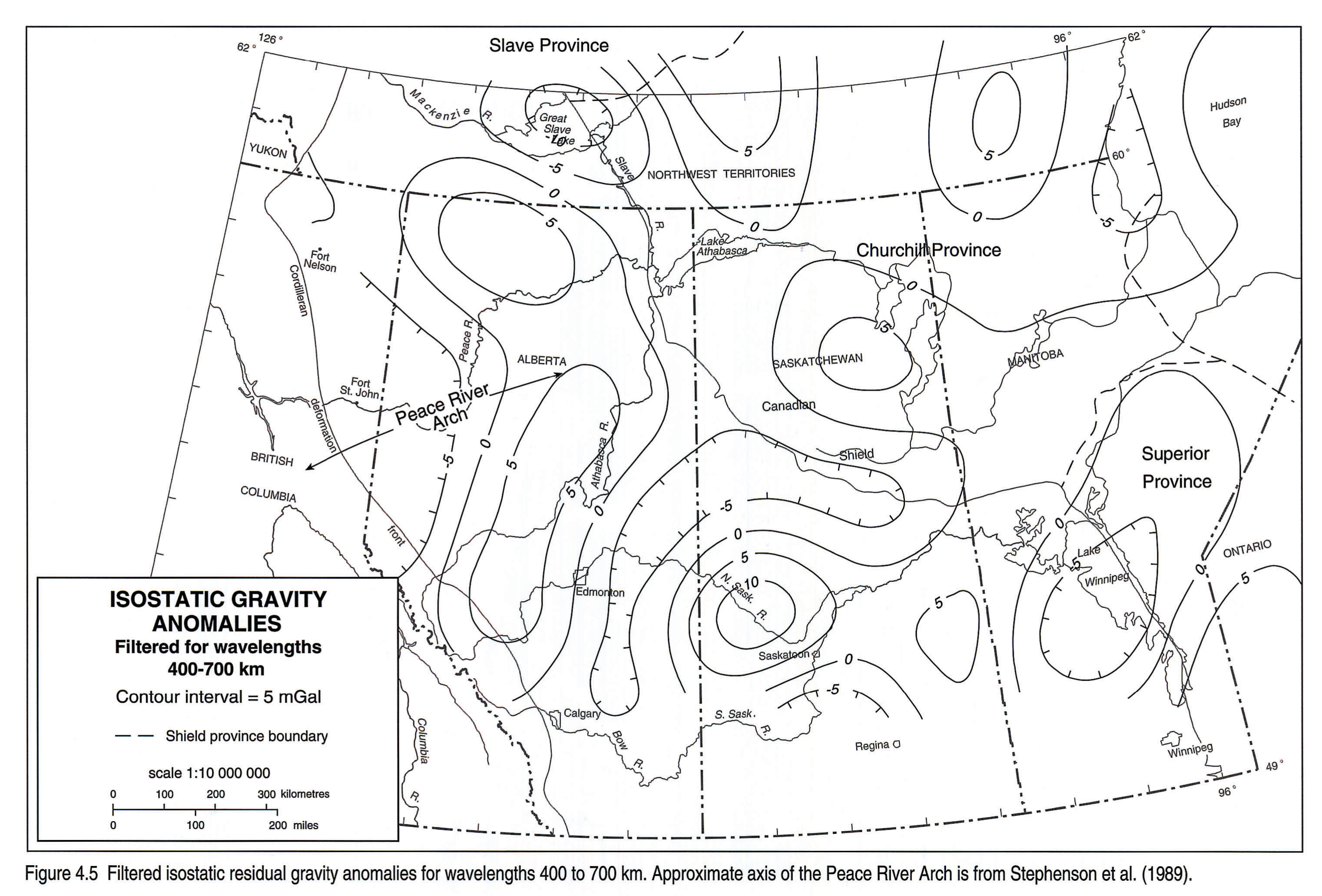
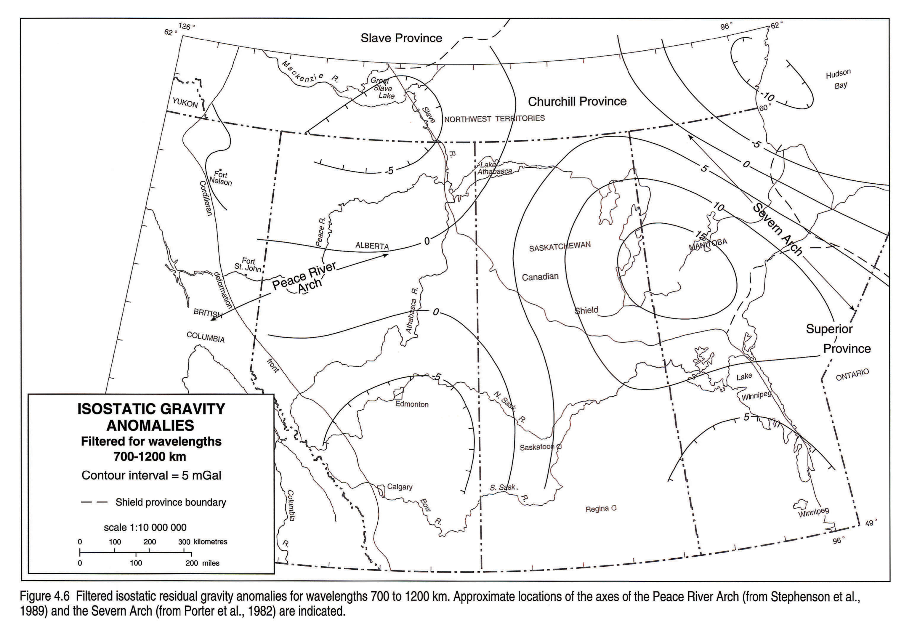
A particularly interesting set of maps from this perspective are the isostatic residual maps of Sprenke and Kanasewich (1982) and Stephenson et al. (1989) (Figs. 4.5 and 4.6). They computed isostatic residuals from the Bouguer gravity field for Western Canada and then filtered these residuals to examine different wavelength components of the gravity field (400-700 km and 700-1200 km). They utilized isostatic residuals of the gravity field, which take into account the effects of isostatically compensated topography (e.g., crustal roots to the Cordillera). However, rather than assuming local compensation (i.e., a crustal root as a direct function of topographic height), Stephenson et al. (1989) used a model of regional compensation that effectively considers the contribution of crustal strength to the support of topography. This contrasts with the approach of Goodacre et al. (1987) but appears to result in a more realistic model of the isostatically compensated gravity field.
On the 400 to 700 km wavelength image (Fig. 4.5), one of the most prominent patterns seems to be associated with the amplitude shift in the gravity along the Kasba Lake-Edmonton gravity low - Thorsby Low, suggesting that this discontinuity extends through much of the crust. Another interesting anomaly occurs in the region of the exposed shield in Manitoba and Saskatchewan, referred to as the Severn Arch (Porter et al., 1982). This positive anomaly is well defined on the 700 to 1200 km wavelength map (Fig. 4.6) but is indistinct at shorter wavelengths. The size and wavelength of this anomaly suggest that it could correspond to a source within the mantle. In particular, is has been postulated on the basis of evidence from wide-angle seismic experiments that the mantle in Archean shield regions is thicker and less dense than in younger regions (Jordan, 1988; Grand and Helmberger, 1984; Anderson, 1990). The Proterozoic Trans-Hudson Orogen is noted for the presence of substantial tracts of juvenile Proterozoic crust (Patchett and Arndt, 1986). It may be that the Severn Arch is a reflection of the differences in mantle thickness and density between the Proterozoic region of Trans-Hudson Orogen and the adjacent Archean shield regions. An additional contribution may arise from the presence of intermediate-velocity lower crust, recognized empirically as being a fundamental part of Proterozoic, but not Archean, crust (Durrheim and Mooney, 1991). Both of these features may give rise to long-wavelength positive anomalies. The latter is testable with seismic refraction studies.
Discussion
Potential field data from the Western Canada Sedimentary Basin can be used to elucidate the structure of the crust that underlies the basin. In contrast to Bouguer gravity anomaly data, aeromagnetic anomaly data provide an effective means of mapping the domainal structure of the shallow basement beneath the sedimentary cover.
In the case of the WCSB, calibration of aeromagnetic anomaly patterns with analogues exposed in the shield, where field relationships and kinematics are known, allows the mosaic of subsurface domains to be placed in a dynamic, tectonic framework (Ross et al. 1991; Ross, 1992). This exercise results in formulation of crustal geometries related to the process of tectonic accretion and amalgamation, which can be tested using seismic reflection profiling. As our understanding of the relation between crustal structure of the basement and sedimentary patterns becomes known, perhaps through the application of seismic reflection profiling, it may become possible to use potential field data to enhance the mapping of shallow basement in the subsurface and to elucidate the evolution of sedimentary and diagenetic patterns.
Acknowledgements
Recent resurgence in investigation of the crystalline basement of Alberta and British Columbia resulted in large part to a question that Pete Gordy asked the senior author at a Cordilleran Tectonics Workshop at Queen's University in 1986. Subsequently, Shell Canada provided listings of wells to basement in Alberta and B.C. and Petro-Canada provided access to their proprietary aeromagnetic compilation of Alberta.
I would like to thank these organizations for their initial support and count them among the many companies (including Mobil, Esso, PanCanadian, Amoco and ERCB) who have provided support and encouragement of basement studies in Western Canada.
Finally, Paul Hoffman is thanked for providing a paradigm of big-picture thinking in the Precambrian evolution of Canada.
References
- Anderson, D.L. 1990. Geophysics of the continental mantle: an historical perspective. In: Continental Mantle. M. Menzies (ed.). Oxford Monographs of Geology and Geophysics, v. 16, p. 1-30.
- Bostock, H.H. 1987. Geology of the south half of the Taltson Lake map-area, District of Mackenzie. In: Current Research, Part A, Geological Survey of Canada, Paper 87-1A, p. 443-450.
- Broome, J. 1990. Generation and interpretation of geophysical images with examples from the Rae Province, northwestern Canada Shield. Geophysics, v. 55, p. 977-997.
- Burwash, R.A. 1957. Reconnaissance of subsurface Precambrian of Alberta. American Association of Petroleum Geologists, v. 41, p. 70-103.
- Burwash, R.A. and Culbert, R.R. 1976. Multivariate geochemical and mineralogical patterns in the Precambrian basement of Western Canada. Canadian Journal of Earth Sciences, v. 13, p. 1-18.
- Burwash, R.A., Baadsgaard, H., and Peterman, Z.E. 1962. Precambrian K-Ar dates from the Western Canada Sedimentary Basin. Journal of Geophysical Research, v. 67, p. 1617-1625.
- Burwash, R.A., McGregor, C.R., and Wilson, J.A. (this volume). Precambrian basement beneath the Western Canada Sedimentary Basin. In: Geological Atlas of the Western Canada Sedimentary Basin. G.D. Mossop and I. Shetsen (comps.). Calgary, Canadian Society of Petroleum Geologists and Alberta Research Council, chpt. 5.
- Coles, R.L., Haines, G.V., and Hannaford, W. 1976. Large scale magnetic anomalies over Western Canada and the Arctic: a discussion. Canadian Journal of Earth Sciences, v. 13, p. 790-802.
- Collerson, K.D., Van Schmus, W.R., Lewry, J.F., and Bickford, M.E. 1988. Buried Precambrian basement in south-central Saskatchewan: provisional results from Sm-Nd model ages and U-Pb zircon geochronology: In: Summary of Investigations 1988. Saskatchewan Geological Survey, Saskatchewan Energy and Mines, Miscellaneous Report 88-4, p. 142-150.
- Cordell, L. and Grauch, V.J.S. 1985. Mapping basement magnetization zones from aeromagnetic data in the San Juan Basin, New Mexico. In: The Utility of Regional Gravity and Magnetic Anomaly Maps. W.J. Hinze (ed.). Tulsa, Oklahoma, Society of Exploration Geophysicists, p. 181-197.
- Dods, S.D., Teskey, D.J., and Hood, P.J. 1985. The new series of 1:1 000 000-scale magnetic anomaly maps of the Geological Survey of Canada: compilation techniques and interpretation. In: The Utility of Regional Gravity and Aeromagnetic Anomaly Maps. W.J. Hinze (ed.). Tulsa, Oklahoma, Society of Exploration Geophysicists, p. 69-87.
- Dods, S.D., Teskey, D.J., and Hood, P.J. 1989. Magnetic anomaly map of Canada. Geological Survey of Canada, Canadian Geophysical Atlas, Map 11, Scale 1:10 000 000.
- Durrheim, R.J. and Mooney, W.D. 1991. Archean and Proterozoic crustal evolution: Evidence from crustal seismology. Geology, v. 19, p. 606-609.
- Garland, G.D. and Burwash, R.A. 1959. Geophysical and petrological study of Precambrian of central Alberta, Canada. American Association of Petroleum Geologists, Bulletin, v. 43, p. 790-806.
- Gastil, G., Diamond, J., Knaack, C., Walawender, M., Marshall, M., Boyles, C., Chadwick, C., and Erskine, B. 1990. The problem of the magnetite-ilmenite boundary in southern and Baja California. In: The Nature and Origin of Cordilleran Magmatism. J.L. Anderson (ed.). Geological Society of America, Memoir 174, p. 19-32.
- Gibb, R.A. 1978. Slave-Churchill collision tectonics. Nature, v. 271, p. 50-52.
- Gibb, R.A. and Thomas, M.D. 1976. Gravity signature of fossil plate boundaries on the Canadian Shield. Nature, v. 262, p. 199-200.
- Gibb, R.A., Thomas, M.P., Lapointe, P.C., and Mukhopadhyay, M. 1983. Geophysics of proposed Proterozoic sutures in Canada. Precambrian Research, v. 19, p. 349-394.
- Goodacre, A.K. 1972. Generalized structure and composition of the deep crust and upper mantle in Canada. Journal of Geophysical Research, v. 77, p. 3146-3161.
- Goodacre, A.K., Grieve, R.A.F., and Halpenny, J.F. 1987. Isostatic gravity anomaly map of Canada. Geological Survey of Canada, Canadian Geophysical Atlas, Map 4, scale 1:10 000 000.
- Grand, S.P. and Helmberger, D.V. 1984. Upper mantle shear structure of North America. Geophysical Journal of the Royal Astronomical Society, v. 76, p. 399-438.
- Green, A.G., Hajnal, Z., and Weber, W. 1985. An evolutionary model of the western Churchill Province and western margin of the Superior Province in Western Canada and the northcentral United States. Tectonophysics, v. 116, p. 281-322.
- Hanmer, S. 1988. Great Slave Lake Shear Zone, Canadian Shield: reconstructed vertical profile of a crustal-scale fault zone. Tectonophysics, v. 149, p. 245-264.
- Henderson, J.B., McGrath, P.H., James, D.T., and Macfie, R.I. 1987. An integrated geological, gravity and magnetic study of the Artillery Lake area and the Thelon Tectonic Zone, District of Mackenzie. In: Current Research, Part A, Geological Survey of Canada, Paper 87-1A, p. 803-814.
- Hoffman, P.F. 1987. Continental transform tectonics: Great Slave Lake Shear Zone (1.9 Ga), northwest Canada. Geology, v. 15, p. 785-788.
- Hoffman, P.F. 1988. United plates of America: the birth of a craton. Annual Review of Earth and Planetary Sciences, v. 16, p. 543-604.
- Hoffman, P.F. 1989. Precambrian geology and tectonic history of North America. In: The Geology of North America - An Overview. A.W. Bally, and A.R. Palmer (eds.). Geological Society of America, The Geology of North America, v. A, p. 447-512.
- Hoffman, P.F. and McGlynn, J.C. 1977. Great Bear Batholith: a volcano-plutonic depression. In: Volcanic Regimes in Canada. W.R.A. Baragar, L.C. Coleman and J.M. Hall (eds.). Geological Association of Canada, Special Paper 16, p. 170-192.
- Jordan, T.H. 1988. The structure and formation of the continental tectosphere. Journal of Petrology, Special Lithosphere Issue, p. 11-37.
- Jones, A.G. and Craven, J.A. 1990. The North American Central Plains conductivity anomaly and its correlation with gravity, magnetic, seismic and heat flow data in Saskatchewan, Canada. Physics of Earth and Planetary Interiors, v. 60, p. 169-194.
- Kanasewich, E.R., Clowes, R.M., and McCloughan, C.H. 1969. A buried rift in western Canada. Tectonophysics, v. 8, p. 513-527.
- Lavoie, D.H. 1958. The Peace River Arch during Mississippian and Permo-Pennsylvanian time. Alberta Society of Petroleum Geologists, Journal, v. 6, p. 211-251.
- Machel, H.G. and Burton, E.A. 1991. Causes and spatial distribution of anomalous magnetization in hydrocarbon seepage environments. American Association of Petroleum Geologists, Bulletin, v. 75, p. 1864-1875.
- Patchett, P.J. and Arndt, N.T. 1986. Nd isotopes and tectonics of 1.9-1.7 Ga crustal genesis. Earth and Planetary Science Letters, v. 78, p. 329-338.
- Pilkington, M. 1991. Mapping elastic lithospheric thickness variations in Canada. Tectonophysics, v. 190, p. 283-297.
- Porter, J.W., Price, R.A., and McCrossan, R.G. 1982. The Western Canada Sedimentary Basin. Philosophical Transactions of the Royal Society of London, v. A305, p. 169-182.
- Robinson, E.S., Poland, P.V., Glover, L., and Speer, J.A. 1985. Some effects of regional metamorphism and geologic structure on magnetic anomalies over the Carolina slate belt near Roxboro, North Carolina. In: The Utility of Regional Gravity and Magnetic Anomaly Maps. W.J. Hinze (ed.). Tulsa, Oklahoma, Society of Exploration Geophysicists, p. 320-324.
- Ross, G.M. 1990. Deep crust and basement structure of the Peace River Arch region: constraints on mechanisms of formation. Bulletin of Canadian Petroleum Geology, v. 38A, p. 25-35.
- Ross, G.M. 1992. Tectonic evolution of the crystalline basement along the Central Transect. In: Alberta Basement Transects Workshop (March 4-5). G.M. Ross, (ed.). Workshop Report 28, LITHOPROBE Secretariat, University of British Columbia, p. 120-138.
- Ross, G.M. and Stephenson, R. A. 1989. Crystalline basement: the foundations of the Western Canada Sedimentary Basin. In: Western Canada Sedimentary Basin: A Case History. B.D. Ricketts (ed.). Calgary, Canadian Society of Petroleum Geologists, p. 33-46.
- Ross, G.M., Parrish, R.R., Villeneuve, M.E., and Bowring, S.A. 1989. Tectonic subdivision and U-Pb geochronology of the crystalline basement of the Alberta Basin, Western Canada. Geological Survey of Canada, Open File 2103.
- Ross, G.M., Villeneuve, M.E., Parrish, R.R., and Bowring, S.A. 1991. Geophysics and geochronology of the crystalline basement of the Alberta Basin, Western Canada. Canadian Journal of Earth Sciences, v. 28, p. 512-522.
- Ross, G.M., Villeneuve, M.E., Thériault, R.J., and Parrish, R.R. (in press). Tectonic evolution of Precambrian basement, Western Canada. Tectonics.
- Sharpton, V.L., Grieve, R.A.F., Thomas, M.D., and Halpenny, J.F. 1987. Horizontal gravity gradient: an aid to the definition of crustal structure in North America. Geophysical Research Letters, v. 14, p. 808-811.
- Sprenke, K.F. and Kanasewich, E.R. 1982. Gravity modelling and isostacy in western Canada. Journal of the Canadian Society of Exploration Geophysicists, v. 18, p. 49-57.
- Stephenson, R.A., Zelt, C.A., Ellis, R.M., Hajnal, Z., Morel-a-l'Hussier, P., Mereu, R.F., Northey, D.J., West, G.F., and Kanasewich, E.R. 1989. Crust and upper mantle structure and origin of the Peace River Arch. Bulletin of Canadian Petroleum Geology, v. 37, p. 224-235.
- Strangway, D.W. 1970. History of the Earth's Magnetic Field. New York, McGraw-Hill, 168 p.
- Sweeney, J.F., Stephenson, R.A., Currie, R.G., and Delaurier, J.M. 1991. Part C, Crustal geophysics. In: Geology of the Cordilleran Orogen in Canada, Chapter 2. H. Gabrielse, and C.J. Yorath (eds.). Geological Survey of Canada, Geology of Canada, no. 4, p. 39-59.
- Teskey, D.J., Hood, P.J., and Dods, S.D. 1989. Vertical gradient of the magnetic anomaly map of Canada. Geological Survey of Canada, Canadian Geophysical Atlas, Map 12, Scale 1:10 000 000.
- Thériault, R.J. and Ross, G.M. 1991. Nd isotopic evidence for crustal recycling in the ca. 2.0 Ga subsurface of Western Canada. Canadian Journal of Earth Sciences, v. 28, p.1140-1147.
- Villeneuve, M.E., Thériault, R. J., and Ross, G.M. 1991. U-Pb ages and Sm-Nd signature of two subsurface granites from the Fort Simpson magnetic high, northwest Canada. Canadian Journal of Earth Sciences, v. 28, p. 1003-1008.
- Villeneuve, M.E., Ross, G.M., Thériault, R.J., Miles, W., Parrish, R.R., and Broome, J. 1993. Geophysical subdivision and U-Pb geochronology of the crystalline basement of the Alberta Basin, Western Canada. Geological Survey of Canada, Bulletin 447.
- Walcott, R.I. 1968. The gravity field of northern Saskatchewan and northern Alberta with maps. Dominion Observatory Gravity Map Series n, p. 16-20.
- Watanabe, R.Y. 1966. Petrology of cataclastic rocks of northeastern Alberta. Unpublished Ph.D. thesis, University of Alberta, 219 p.
- Wright, G.N., McMechan, M.E., and Potter, D.E.G. (this volume). Structure and architecture of the Western Canada Sedimentary Basin. In: Geological Atlas of the Western Canada Sedimentary Basin. G.D. Mossop and I. Shetsen (comps.). Calgary, Canadian Society of Petroleum Geologists and Alberta Research Council, chpt. 3.
- Zelt, C.A. and Ellis, R.M. 1989. Comparison of near-coincident crustal refraction and extended vibroseis reflection data, Peace River region, Canada. Geophysical Research Letters, v. 16, p. 843-846.