Chapter 9 - Middle Ordovician to Lower Devonian Strata of the Western Canada Sedimentary Basin |
|
| Chapter Sections | Download |
Authors: B.S. Norford - Geological Survey of Canada, Calgary F.M. Haidl - Saskatchewan Geological Survey, Regina R.K. Bezys - Manitoba Energy and Mines, Winnipeg M.P. Cecile - Geological Survey of Canada, Calgary H.R. McCabe - Consultant, Winnipeg D.F. Paterson - Saskatchewan Geological Survey, Regina
Introduction
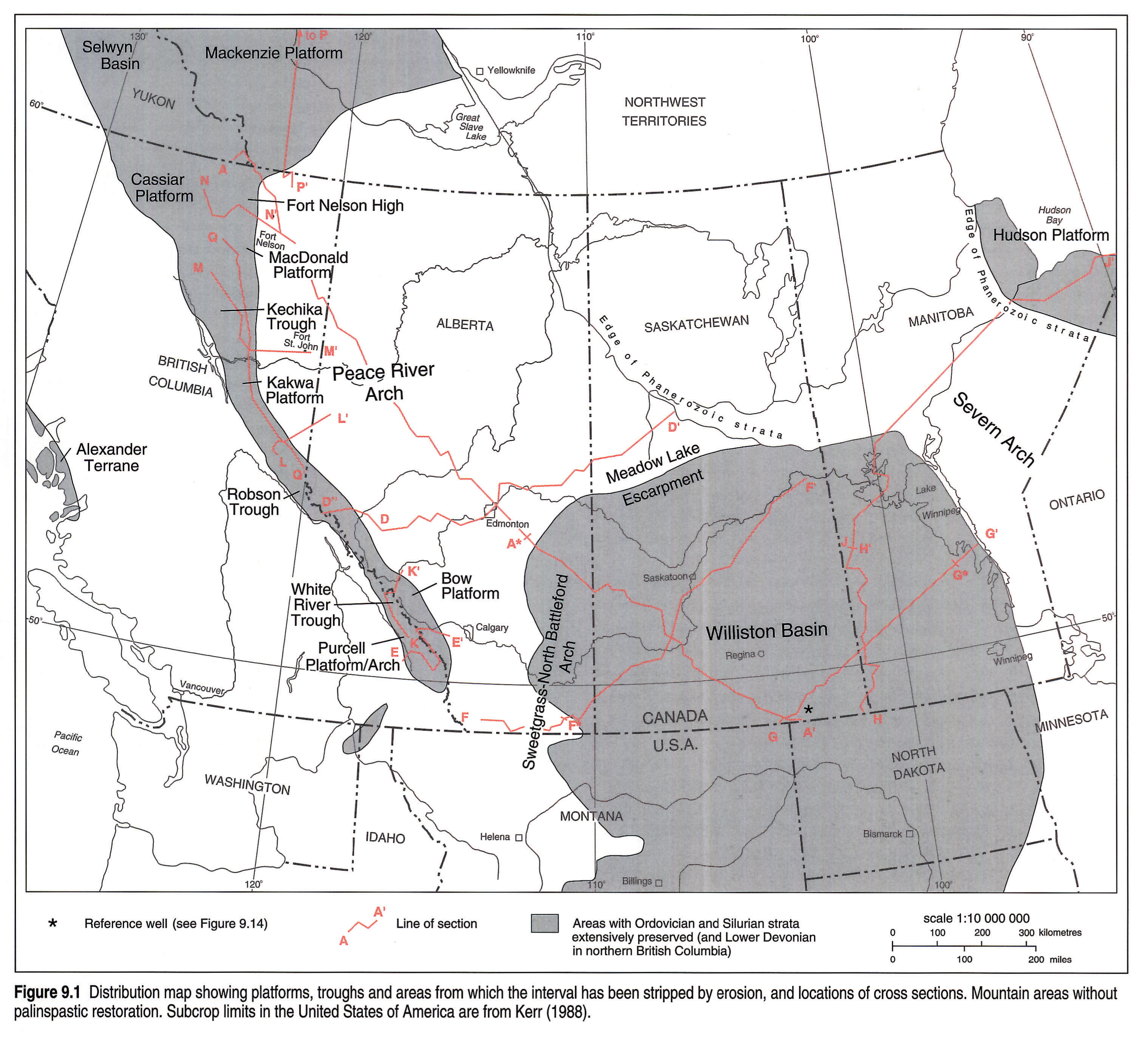
Although originally depositionally continuous, Middle Ordovician to Lower Devonian rocks are preserved in two distinct and separate areas within the Western Canada Sedimentary Basin: the Williston Basin and the mountain outcrops (Figs. 9.1, 9.2, 9.3, 9.4). The stratigraphic package primarily corresponds to the Tippecanoe Sequence (Sloss, 1963) but includes older (uppermost Sauk Sequence) and younger (lowest Kaskaskia Sequence) rocks in the mountains. Its present distribution is severely constrained by the effects of several later episodes of erosion. The entire succession is missing from virtually all of the basin north of the Meadow Lake Escarpment, and Middle Devonian rocks rest directly on the Precambrian in much of this region. The base of the succession is a regional unconformity, except in the Rocky Mountains, where it is conformable within the basin facies and within the immediately adjacent platform facies. Several other unconformities are present within the Middle Ordovician to Lower Devonian succession.
The thick outcrop sequences (up to 2300 m) of British Columbia, Alberta and the District of Mackenzie disappear abruptly eastward and southward in the subsurface, below Devonian unconformities. Lower Silurian Nonda carbonates (up to 270 m) are the only part of these sequences with any significant extension into the subsurface. Preserved extensively in the subsurface of southern Saskatchewan and Manitoba and southeastern Alberta are strata that represent an early development of the Williston Basin. A basal clastic unit (up to 68 m) is restricted to Saskatchewan and Manitoba and a sequence of platform carbonates (up to 400 m) extends over the entire area of preservation. These rocks extend into outcrop in Manitoba and in east-central Saskatchewan. Their easternmost extent is marked by outcrops at Lake Winnipeg; the western feather-edge (basal Red River Formation, subsurface) is about 150 km west of the Alberta-Saskatchewan boundary.
Previous Work
By 1890, Silurian rocks had been recognized in outcrop in southern Manitoba and in the southern Rocky Mountains; these included strata subsequently designated as Ordovician. Reconnaissance studies later documented the presence of the stratigraphic interval in the northern Rocky Mountains, in the Yukon, in the District of Mackenzie and in northern Manitoba. Drilling led to its discovery in the subsurface of the southern plains. In the 1964 atlas (McCrossan and Glaister, 1964), Porter and Fuller presented an excellent synthesis of the subsurface development and Norford outlined the outcrop distribution in the Rocky Mountains as far north as the British Columbia-Yukon boundary. Lower Devonian rocks later were recognized in northern British Columbia. Since 1964, extensive drilling, stratigraphic testholes and sedimentological studies have added much detail to the knowledge of the subsurface development in the plains. Knowledge of the outcrop regions of the Rocky Mountains and of the Territories has grown substantially through systematic mapping and stratigraphic studies but virtually no sedimentological investigations have been attempted. East of the Rocky Mountains and south of the Mackenzie River, studies of the subsurface revealed that Middle Ordovician to Lower Devonian rocks extended only short distances into the subsurface from the outcrop regions. Recent syntheses of the stratigraphic interval include Cecile and Norford (in press), Osadetz and Haidl (1989), and Norford (1991) for the mountain regions. These, together with Norford (1964) and Porter and Fuller (1964), provide a comprehensive bibliography of the Middle Ordovician to Lower Devonian stratigraphic interval of the Western Canada Sedimentary Basin.
Geological Framework
During the early Paleozoic, a miogeocline lay next to the western margin of the North American craton. The transition between them (close to Q-Q' and to the boundary between southern Alberta and British Columbia in Fig. 9.1) was abrupt at most times and marked by slope environments that separated the shallow waters of the craton from the deep ocean. The western margin of the North American continent probably lay just beyond the Cassiar and Purcell platforms (Fig. 9.1). The North American continent straddled the equator and sediments accumulated in warm, tropical seas. The craton itself was low lying and sediments were mature in character with little argillaceous detritus, but there were some persistent highs, such as the Peace River Arch, which from time to time shed quartz sands into the marine environments.
The Ordovician to Lower Devonian rocks that are now preserved in the Western Canada Sedimentary Basin are merely remnants of very extensive sheets of sediment that were deposited over much of the craton and its westward ocean margin. Later periods of erosion removed the entire stratigraphic interval from most of the region (Figs. 9.5, 9.6, 9.7, 9.8, 9.9, 9.10, 9.11, 9.12 left pane, 9.12 right pane, 9.15, 9.16, 9.17, 9.18, 9.19), but outliers are preserved in many places. Generally, the strata consist of shallow-water carbonates and minor clastics and evaporites on the craton, bordered to the west by basinal shales and limestones (Figs. 9.1, 9.6). The change of facies occurred at a fairly abrupt slope from the platform into deeper water. Outboard of this facies change, two highs hosted carbonate platforms (Purcell Platform and Cassiar Platform, Fig. 9.1), which themselves were bordered westward by further developments of basin facies. Volcanic complexes were developed near the platform margin on at least two occasions but seem to have had very limited lateral extents.
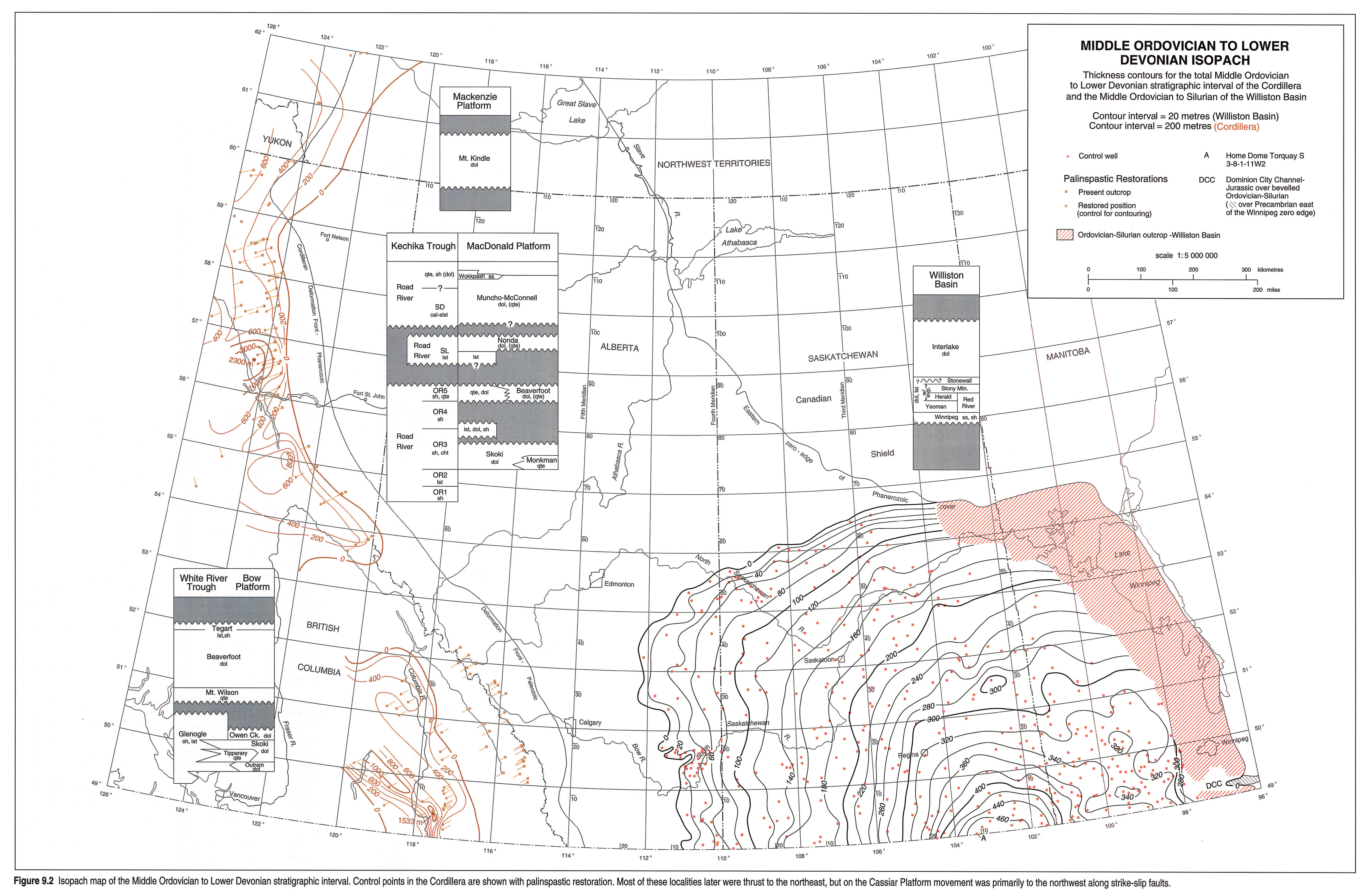
In the central part of the craton, subsidence of the ancestral Williston Basin began in Middle Ordovician time. The axis of this gentle depression shifted several times within the Tippecanoe interval but the areas of greatest subsidence were in northwestern North Dakota (Fig. 9.2; Porter and Fuller, 1964; Kent and Christopher, this volume, Chapter 27). Depositional thickening southward mostly developed within the Winnipeg, Red River and Interlake units. Thickness variations and facies distributions within various stratigraphic units indicate that some intrabasinal structures affected depositional patterns during Tippecanoe time (Osadetz and Haidl, 1989). The area of deposition at times extended well beyond the limits of the present-day structural Williston Basin, and many of the units were depositionally continuous with those of the Bow, Kakwa, MacDonald, Mackenzie, and Hudson platforms (Fig. 9.1). In the Canadian part of the Williston Basin, the subsurface development of these strata is thickest (about 480 m) in southeastern Saskatchewan, adjacent to its maximum (more than 760 m, Gerhard and Anderson, 1988) in northwestern North Dakota. The preservation of these lower Paleozoic strata during Late Silurian and Early Devonian erosion was due to epeirogenic tectonics creating a broad depression, so that the Ordovician and Silurian rocks were preserved below the Middle Devonian rocks.
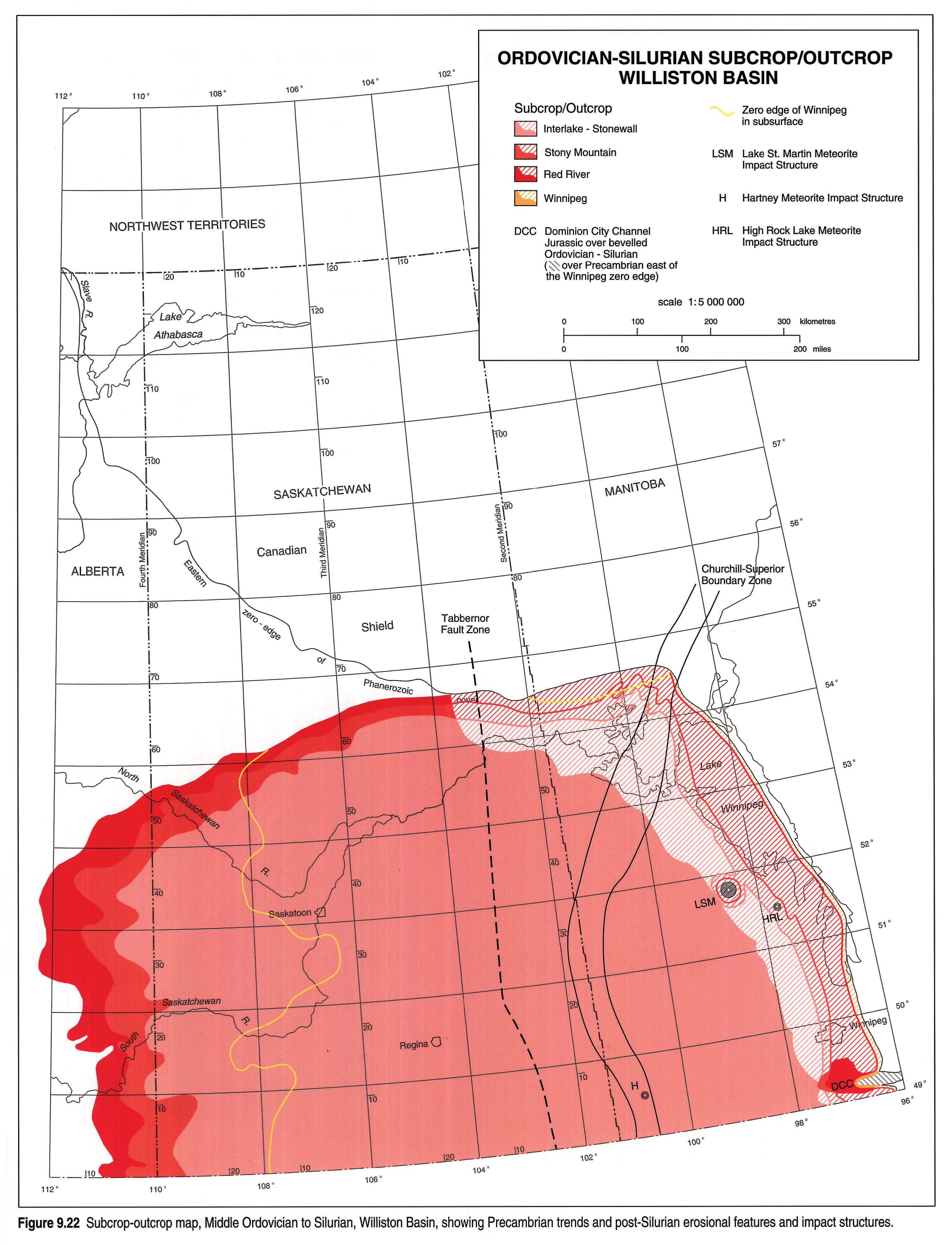
At the north margin of their area of preservation, the lower Paleozoic rocks form an erosional escarpment (Meadow Lake) that limited a Middle Devonian sea within which the lower Elk Point evaporites were deposited (Meijer Drees, 1986). At the northeast margin of the Williston Basin, erosion on the Severn Arch (a Devonian or later feature) removed Upper Ordovician and Silurian strata that apparently were continuous between the Williston Basin and the Hudson Bay Basin (Fig. 9.19). The elbow in the distribution pattern (Fig. 9.1), between the easterly trending feather-edge in the subsurface and the northerly trending Manitoba outcrops, coincides with the boundary between the Churchill and Superior provinces (Fig. 9.22) and may indicate the resurrected effect of this Precambrian structural trend.
Sea-level changes driven by eustatic and glacio-eustatic events are recorded by unconformities and depositional cycles in the Williston Basin and in the mountains. Successive transgressions that began in the Middle Ordovician resulted in inundation of most of the Canadian part of the North American craton by Late Ordovician time, when carbonate deposition seemingly extended from the Mackenzie, Kakwa and Bow platforms eastward to the Williston Basin and the Hudson Bay Basin and northward into the present Arctic Islands. Within the subsurface of the Western Canada Sedimentary Basin, the present preservation of segments of these widespread carbonates is a function of subsequent erosion and the effects of episodes of uplift of the Peace, Sweetgrass-North Battleford and Severn arches, respectively in the northwest, southwest and northeast, and of the Transcontinental Arch (not shown within Fig. 9.1) in the south.
Stratigraphy
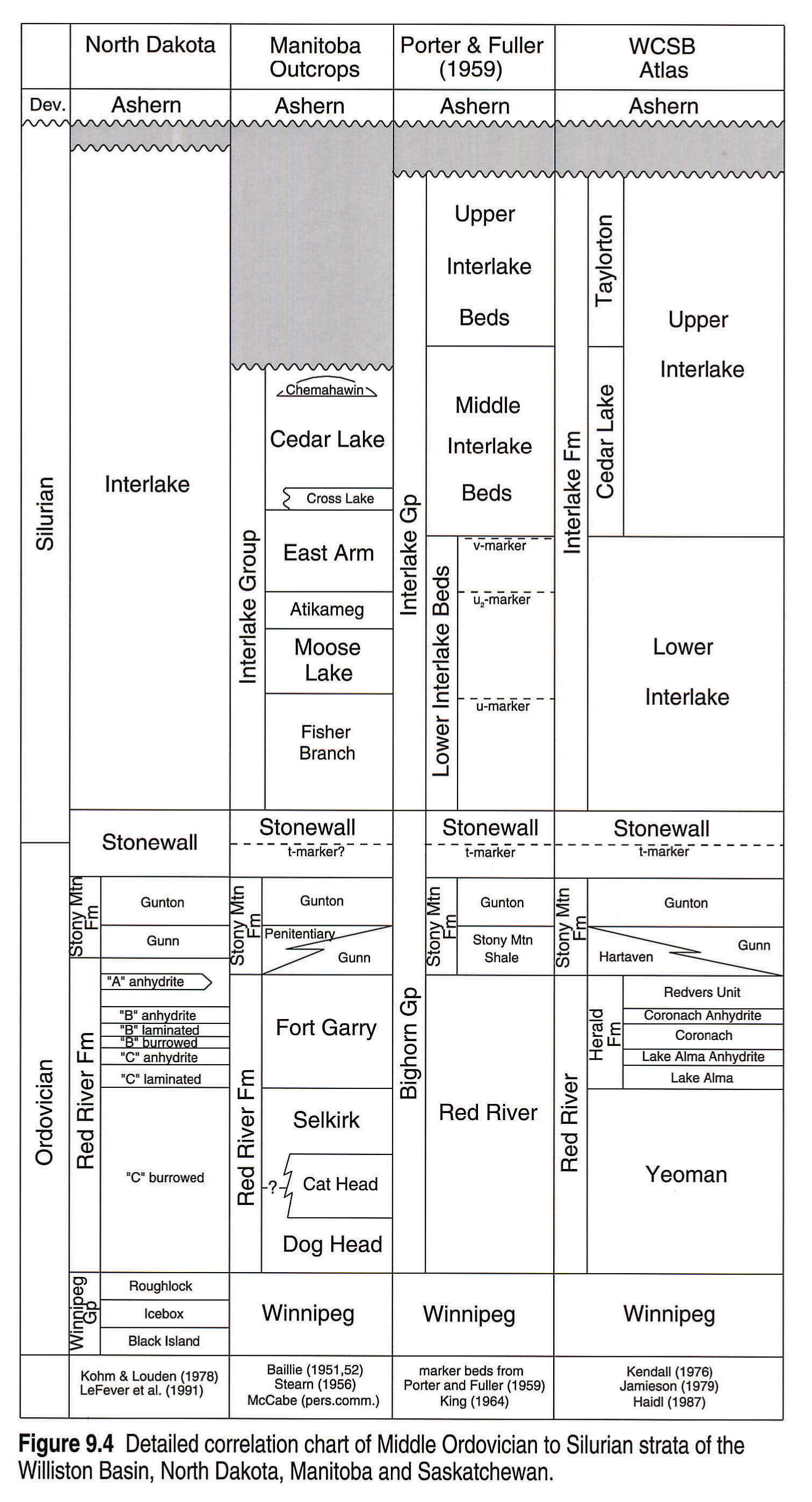
Figure 9.3 provides an overview of the stratigraphic nomenclature, but many of the units have been subdivided for local purposes, both formally and informally. Unconformities are prominent and there is a westward change from formations of the cratonic platform into the Road River Group and the Glenogle Formation of the basinal facies. Figure 9.4 gives more detail for the Williston Basin.
In the miogeocline, the top of the stratigraphic interval is drawn within the Kaskaskia Sequence, at the base of the Bear Rock-Stone Assemblage of Morrow and Geldsetzer (1989), although the Stone Formation may include Lower Devonian (Emsian) strata. The base of the interval is drawn at the base (uppermost Arenig) of the Skoki Formation and its associated quartz sand bodies (Monkman and Tipperary quartzites) and the slightly older (about mid-Arenig) bases of the Glenogle and Road River units in the basinal facies. In the United States, the beginning of the Tippecanoe Sequence customarily is placed at the base of the Whiterock Series, which corresponds approximately to the base of the Llanvirn Series (Fig. 9.3). In the Williston Basin, the base of the interval (Winnipeg Formation) is younger (Caradoc) than in the miogeocline, and the top of the interval (Upper Interlake unit) is older (late Llandovery or Wenlock). The boundaries between the Tippecanoe and the Sauk and Kaskaskia sequences are abrupt on the craton, where hiatuses between the sequences were at their maxima. In contrast, the boundaries are blurred in the miogeocline as the bounding unconformities lose their impacts.
Mountain Region
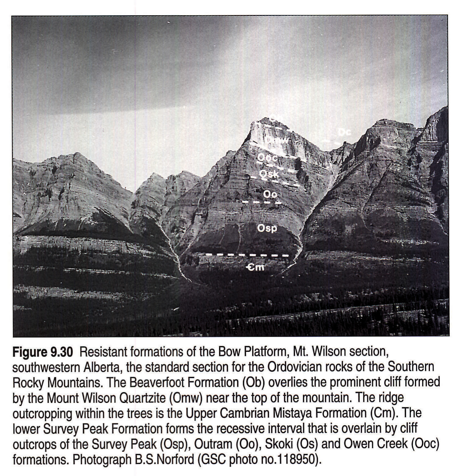
The Bow, Purcell, Kakwa, MacDonald, Cassiar and Mackenzie platforms each have sequences of sediments, preponderately carbonates (e.g., Fig. 9.30), with unconformities that document transgressions at various horizons, many of which are common to most of the platforms and to the Williston Basin. The detailed stratigraphy is beyond the scope of this chapter and is available elsewhere (Norford, 1969; Norford et al., 1967; Taylor and MacKenzie, 1970; Norford and Macqueen, 1975; Cecile and Norford, 1979; Pugh, 1983; Morrow and Geldsetzer, 1989; Osadetz and Haidl, 1989; Norford, 1991). From time to time, large amounts of clean, well-rounded quartz sand were transported westward, southwestward and southward from the Peace River Arch into and within the Bow, Kakwa and MacDonald platforms (as Monkman, Tipperary, Mount Wilson, "quartzite-dolomite unit" and Wokkpash units and as components of the Beaverfoot, Nonda and Muncho-McConnell formations) and sometimes into the ocean basin (Road River OR5 unit and as turbidites within the Glenogle). Other than these sandstones, the rocks of these platforms are dominantly subtidal and intertidal limestones and dolomites (Skoki, Beaverfoot, Mount Kindle, Nonda). Some units indicate more saline conditions (Owen Creek, Muncho-McConnell, Peel), but evaporites are very rare. Oncoliths and pisoliths are prominent at some horizons within the Skoki Formation. Biostromal horizons are common in the Beaverfoot, Mount Kindle and Nonda formations. Small bioherms are known within the Nonda and a small coral bioherm has been reported in the Beaverfoot (Jansa, 1970). Stromatolite mounds are present in the Skoki of the MacDonald Platform (Cecile, 1989). Shaly intervals are rare in the platform environments except in the Tegart and in basal parts of the Beaverfoot and Mount Kindle. Carbonate slope breccias (Nonda) and carbonate and quartz-sand turbidites (from Skoki and Tipperary sources) are present at the western edges of the MacDonald and Bow platforms and on the adjacent slopes. Two small occurrences of volcanic rocks are known within the carbonates of the MacDonald and Kakwa platforms, both close to the western edges of the platforms (lower Middle Ordovician Skoki; Lower Silurian Beaverfoot).
The indigenous sediments of the ocean basin and deep-slope environments are shales, platy limestones, argillaceous limestones and dolomites and rare cherts and tuffs (Glenogle Formation and Road River Group; Cecile and Norford, 1979 and in press; Norford, 1979, 1991; Norford and Jackson, in press). However in the Late Silurian of northern British Columbia there was a significant lithological change, with siliceous siltstones and mudstones dominating. The change was accompanied by erosional breaks throughout this part of the miogeocline.
Mountain Cross Sections
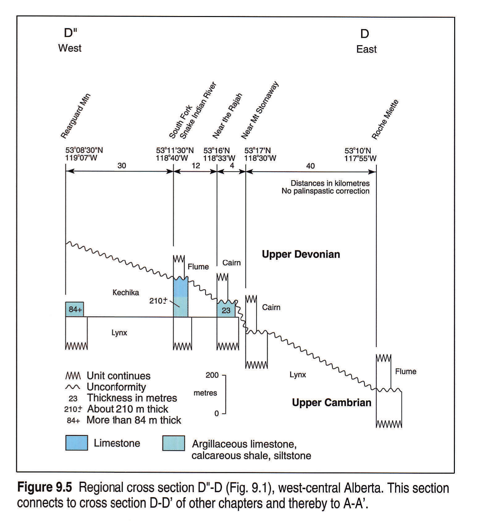
Comments follow here and below (Williston Basin cross sections) on the distribution of the strata within the cross sections that are common to all chapters and also within the cross sections unique to Chapter 9. No subsurface cross sections are shown for B-B', C-C' and D-D', which have negligible development of the Middle Ordovician to Lower Devonian interval. However the outcrop cross sections D"-D, L-L' and N-N' (Figs. 9.5, 9.8 and 9.10) do provide links to the western ends of D-D', C-C' and B-B'.
D"-D (Fig. 9.5) shows that the stratigraphic package is entirely missing in the Jasper region of the southern Rocky Mountains. The Kechika (mostly Lower Ordovician) is truncated eastward within the Front Ranges below the sub-Devonian unconformity.
E-E' (Fig. 9.6) shows that the stratigraphic package is missing in the axial region (Delphine Creek) of the Purcell Arch where Middle Devonian rocks rest directly on the Precambrian. Eastward, across the southern Rocky Mountains, the sub-Middle Devonian unconformity rises stratigraphically with basinal (Glenogle) and platformal (Tipperary, Skoki, Owen Creek, Mount Wilson, Beaverfoot, Tegart) units preserved below it. The belt of Middle Ordovician facies change (platform to basin) near North White River represents a southeast continuation of the Kicking Horse Rim that marked similar facies changes in Cambrian time. Eastward, the sub-Upper Devonian unconformity cuts below the Middle Ordovician within the eastern Main Ranges.
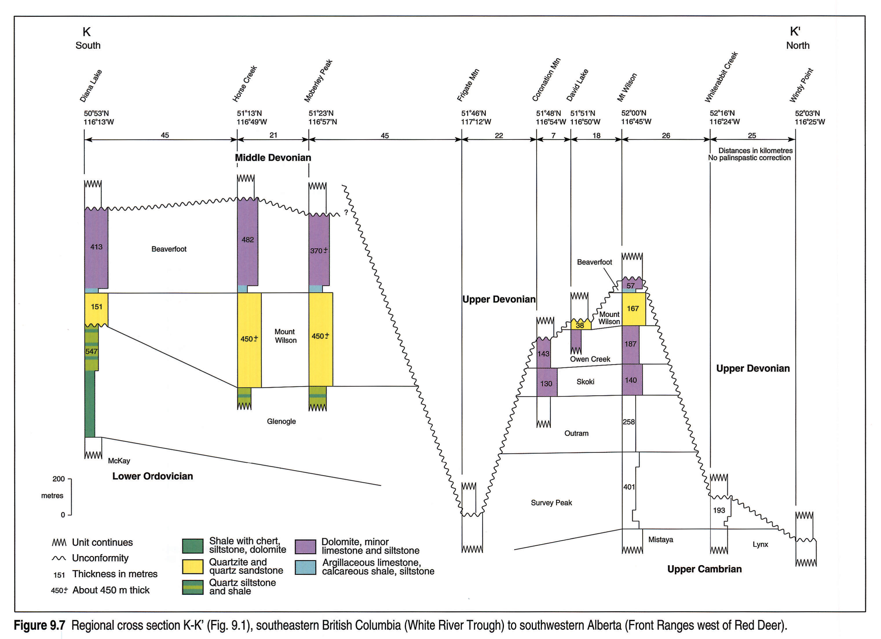
K-K' (Fig. 9.7) shows the same pattern of facies change in the southern Rocky Mountains as E-E' (Fig. 9.6) but with the sub-Upper Devonian unconformity truncating the sub-Middle Devonian unconformity west of the Alberta-British Columbia boundary. Documentation of the Middle Ordovician facies changes near Frigate Mountain from the White River Trough (Glenogle) to the Bow Platform (Outram-Skoki-Owen Creek) is impossible because of downcutting by the sub-Upper Devonian unconformity. Farther east, the same unconformity cuts down to the Upper Cambrian within the Front Ranges.
L-L" (Fig. 9.8) shows sub-Middle Devonian and sub-Upper Devonian unconformities in the central Rocky Mountains. These cut down eastward through the Silurian and Ordovician units so that the Devonian rests on Lower Ordovician Kechika in the eastern outcrops.
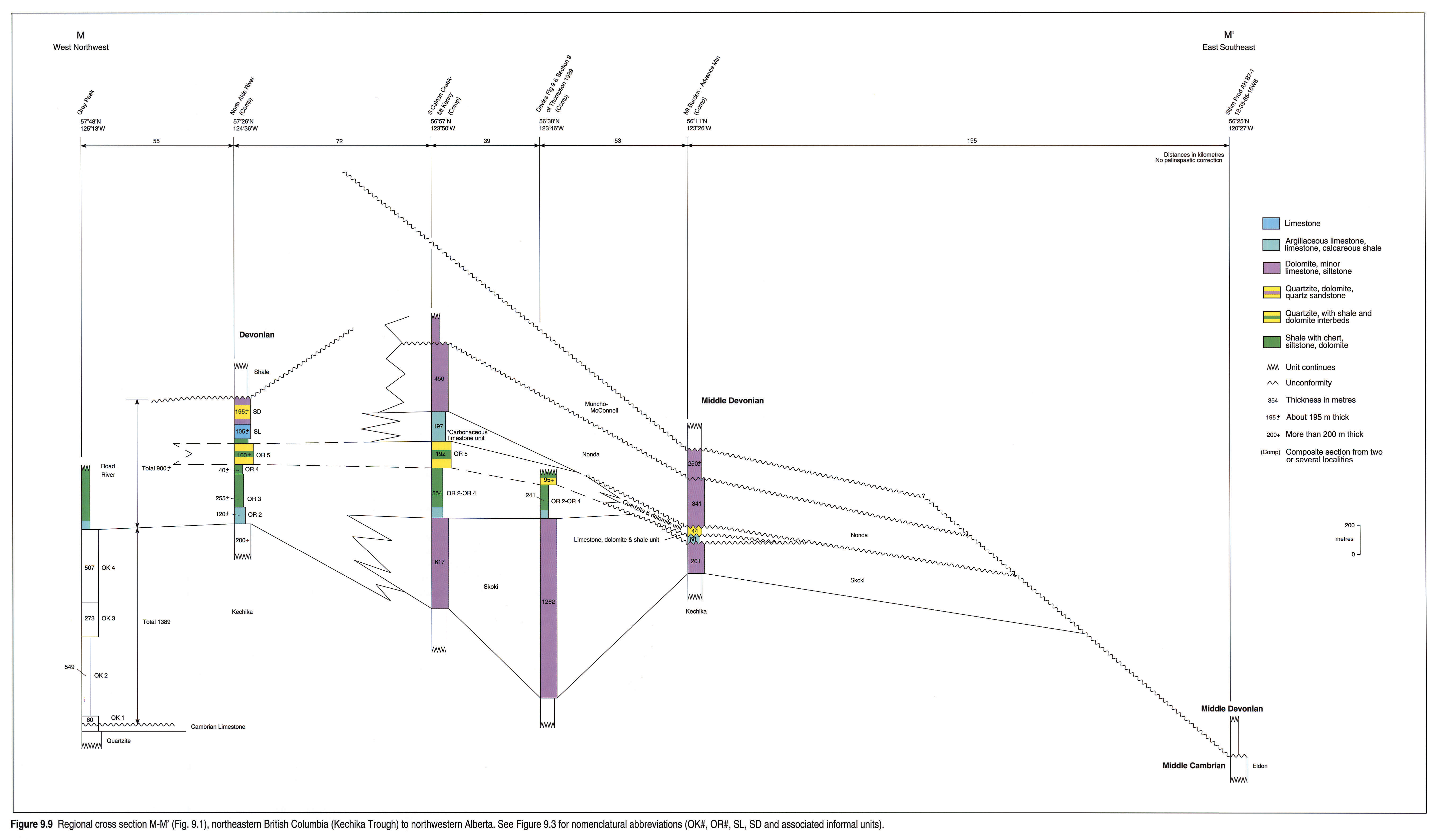
M-M' (Fig. 9.9) outlines changes of facies in the northern Rocky Mountains from the basin east into platformal facies but with a distinct Upper Ordovician quartz-sand-rich unit (OR 5) extending westward into the Kechika Trough from the Peace River Arch (Norford, 1991). The sub-Nonda unconformity trims Ordovician units and a sub-Middle Devonian unconformity cuts below the Ordovician in the subsurface adjacent to the mountains.
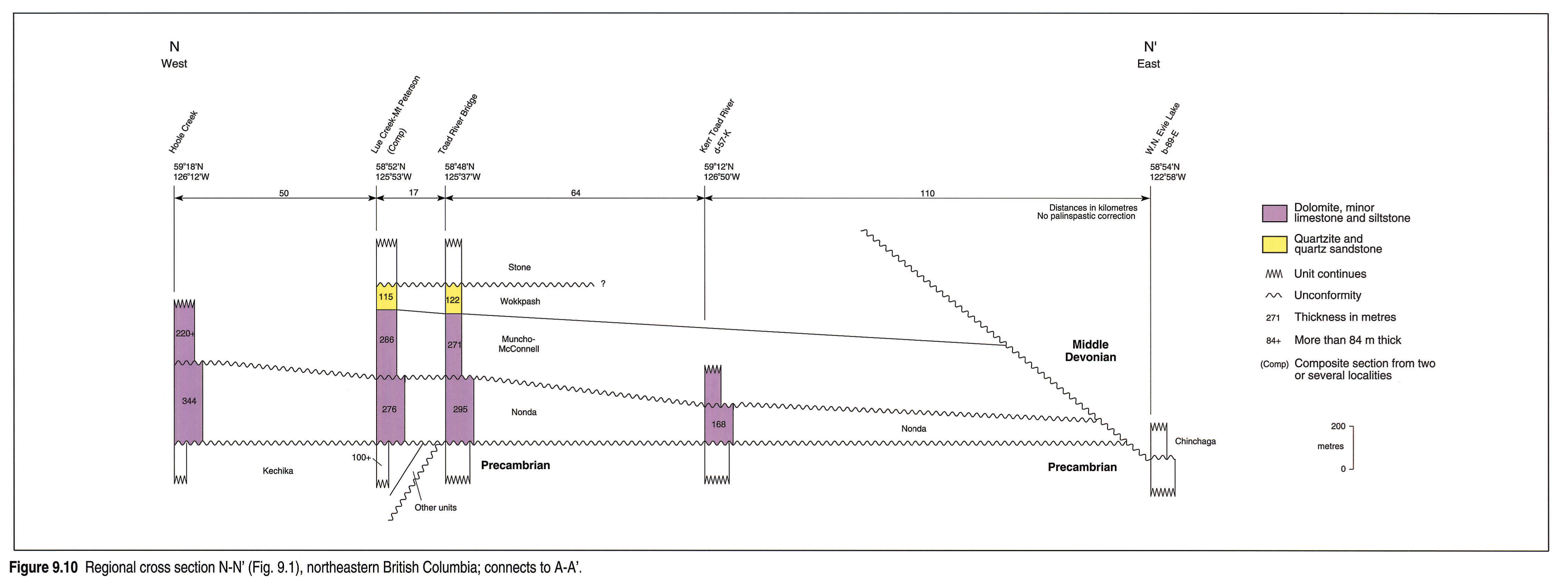
N-N' (Fig. 9.10) is located farther north within the northern Rocky Mountains and shows that pre-Lower Silurian units are cut out eastward below the sub-Nonda unconformity within the mountains. However, both the Nonda itself and the Muncho-McConnell extend eastward into the subsurface beyond the mountains, where they are ultimately cut out below the sub-Middle Devonian unconformity.
P-P' (Fig. 9.11) illustrates that only a thin remnant (lower Mount Kindle) of the Mackenzie Platform sequence extends southward into the Atlas area (Meijer Drees, 1975). The sub-Middle Devonian unconformity cuts down into the Precambrian.
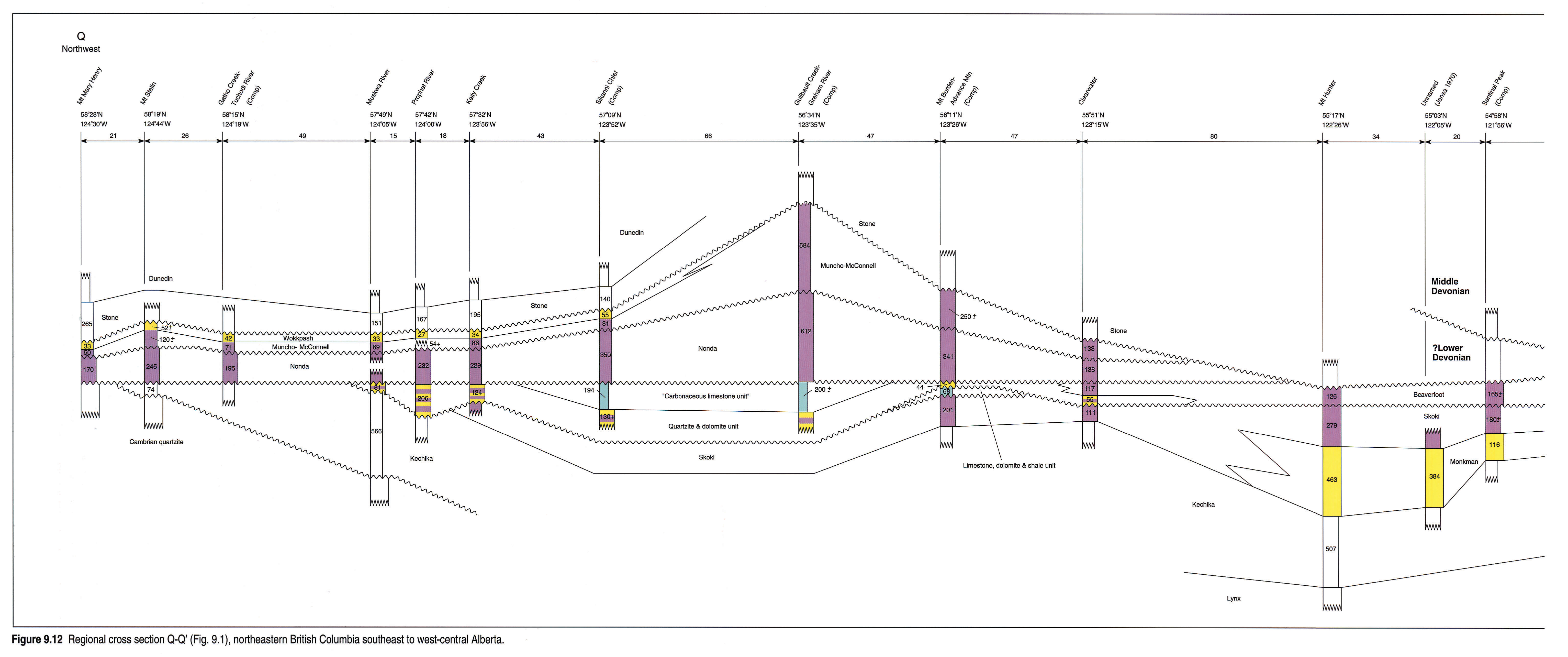
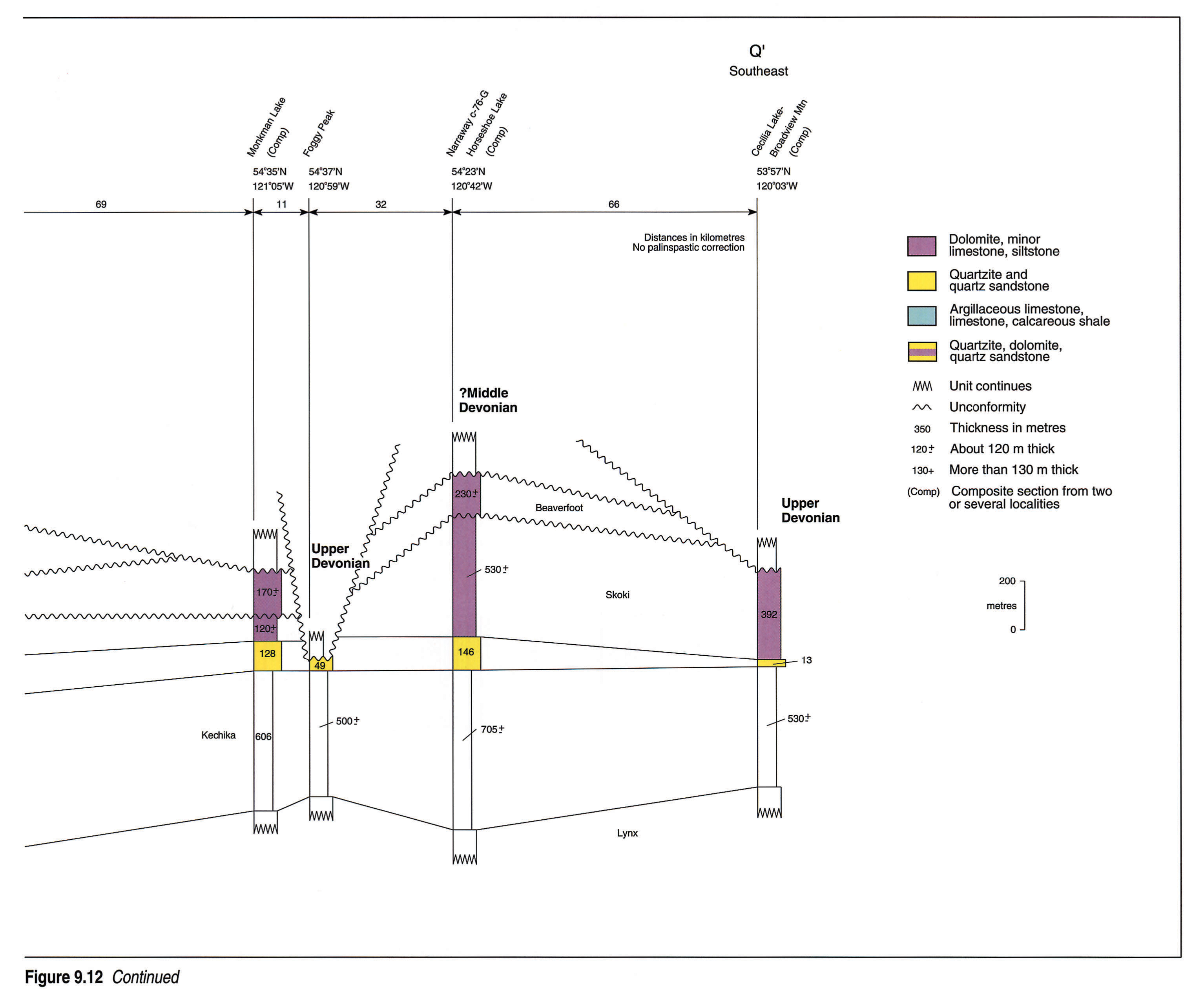
Q-Q' (Fig. 9.12 left pane, 9.12 right pane) is a lateral cross section within the platform in the northern and central Rocky Mountains. Unconformities have had substantial effects, both within the stratigraphic package itself and by the downcutting of the sub-Middle Devonian and sub-Upper Devonian unconformities. Lateral facies changes within the package mostly result from the local presence of significant bodies of quartz sandstone. The Monkman Quartzite is a thick unit equivalent to the lower Skoki. The "quartzite and dolomite unit" is equivalent to the lower Beaverfoot and similar quartz sandstone continues westward as the coeval OR 5 unit of the Road River. The Wokkpash Quartzite is laterally equivalent to some of the upper (Lower Devonian) part of the Muncho-McConnell.
Williston Basin
Because of its extensive subsurface development, the succession in the Williston Basin area is outlined in much more detail than for the rest of the Atlas region (Fig. 9.4). A major unconformity separates the Tippecanoe Sequence from the underlying rocks. In most of the region these latter rocks are shales and argillaceous and glauconitic siltstones and sandstones of the Deadwood Formation (Upper Cambrian to Lower Ordovician; Slind et al., this volume, Chapter 8) but beyond the eastern erosional limit of the Deadwood, the Tippecanoe Sequence rests directly on Precambrian rocks. Tippecanoe sedimentation began with a Middle Ordovician marine transgression from the southeast and deposition of the Winnipeg Formation. The distribution of Winnipeg lithofacies indicates three phases of deposition of basin margin sands and offshore muds (Vigrass, 1972; Kessler, 1991). The top of the Winnipeg marks a regression with associated erosion (Paterson, 1971; Kendall, 1976) but the contact also has been interpreted as transitional (Porter and Fuller, 1959; Vigrass, 1972; McCabe, 1978).
A widespread early Late Ordovician trangression followed, with deposition of burrow-mottled carbonates (Yeoman Formation; lower Red River; Fig. 9.4 shows subdivisions of these units). The transgression extended to the Hudson Platform to the east and northeast and to New Mexico to the south but did not submerge the Bow, Kakwa, McDonald and Mackenzie platforms; these were not transgressed until later in the Late Ordovician (Early Silurian for the MacDonald Platform).
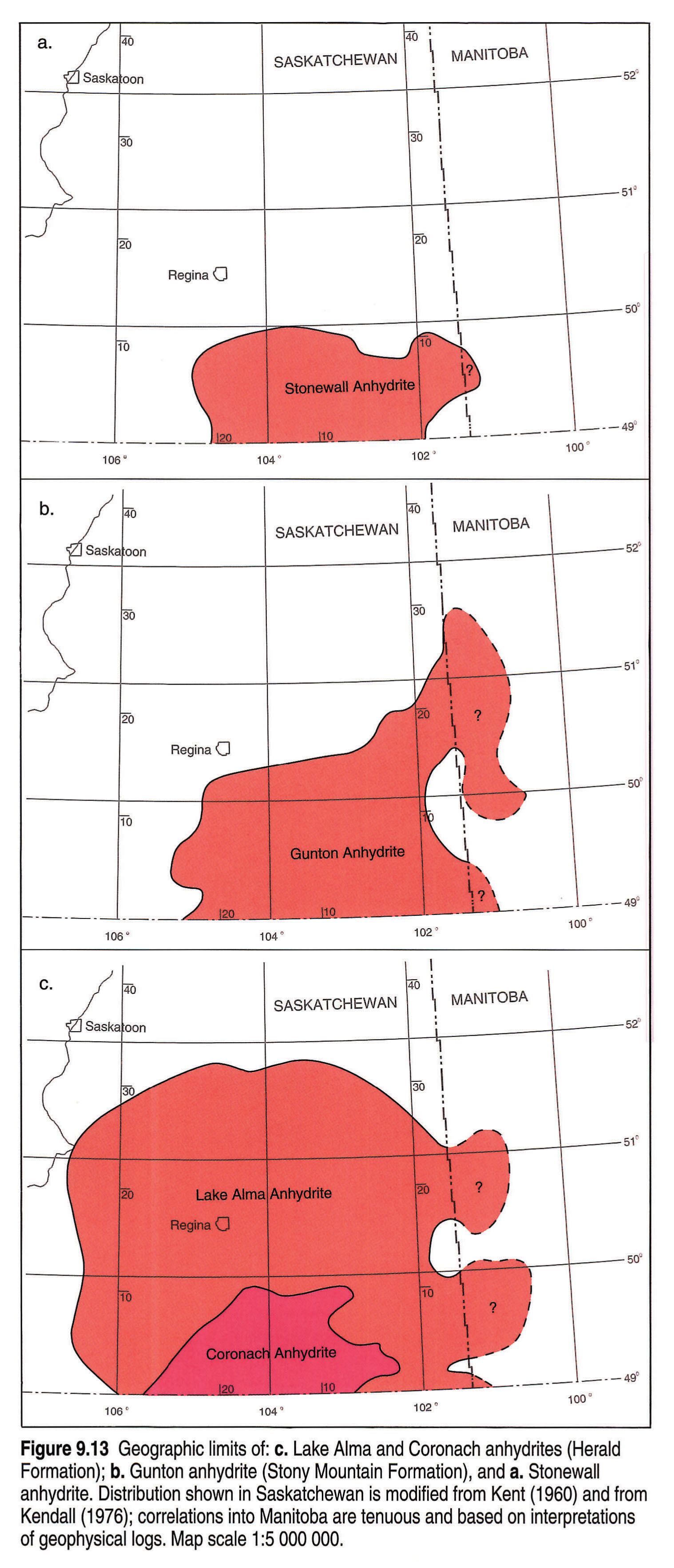
The overlying formations of the Williston Basin are characterized by cyclic sedimentation commencing with three carbonate-evaporite cycles in the Herald Formation (upper Red River; Fig. 9.4 shows subdivisions). Complete cycles consist of basal, thin, argillaceous dolomites, commonly arenaceous, overlain by fossiliferous mudstones/wackestones (commonly burrowed and dolomitized), laminated dolomites, and capping anhydrites (Kendall, 1976, 1988; Haidl, 1990). The evaporites of these and the later cycles are restricted to the central parts of the Williston Basin (Fig. 9.13). Renewed transgression produced deeper water environments, documented by carbonates, argillaceous carbonates and calcareous shales of the lower Stony Mountain Formation; this transgression also is documented on the Bow, Kakwa, and Mackenzie platforms. Next, sequences of carbonate-evaporite cycles, constituting the upper Stony Mountain, Stonewall and Lower Interlake units, were deposited. The evaporite portions of the Lower Interlake cycles are restricted to North Dakota and thus are not shown in Figure 9.13. Noncyclic carbonate sedimentation followed and continued without any major interruption during much of the rest of Interlake deposition ("Middle Interlake" of Porter and Fuller, 1959, 1964; Cedar Lake of Stearn, 1956). However, in the central part of the basin, the youngest part of the sequence ("Upper Interlake" of Porter and Fuller, 1959, 1964; "Taylorton" of Jamieson, 1979 and of Haidl, 1987) consists of dolomites with brecciated textures, desiccation cracks, fenestral fabrics, dolomite cements and erosion surfaces. These indicate periodic subaerial exposure and vadose diagenesis of carbonates deposited under marine or freshwater conditions (Roehl, 1967; Magathan, 1987; Haidl, 1987). There may be an unconformity between these rocks and the underlying parts of the Interlake (Porter and Fuller, 1964; Osadetz and Haidl, 1989). Regional uplift followed deposition of the Interlake and perhaps younger rocks (similar to those preserved in the Hudson Bay Basin, Fig. 9.19), and across the entire Williston Basin the Tippecanoe Sequence was truncated by erosion associated with the sub-Devonian unconformity. At the northern erosional edge, differential erosion of the Ordovician carbonates and the clastics below formed a relatively steep slope, the Meadow Lake Escarpment (Haidl, 1989; Slind et al., this volume, Chapter 8). Later, this escarpment limited the areal distribution of the Middle Devonian sea in which the lower Elk Point evaporites accumulated. The basal Devonian rocks are the Ashern Formation (probably Eifelian), except in southwestern Saskatchewan and southeastern Alberta, where younger Devonian strata progressively onlap paleotopographic highs of Tippecanoe strata.
Reference Well
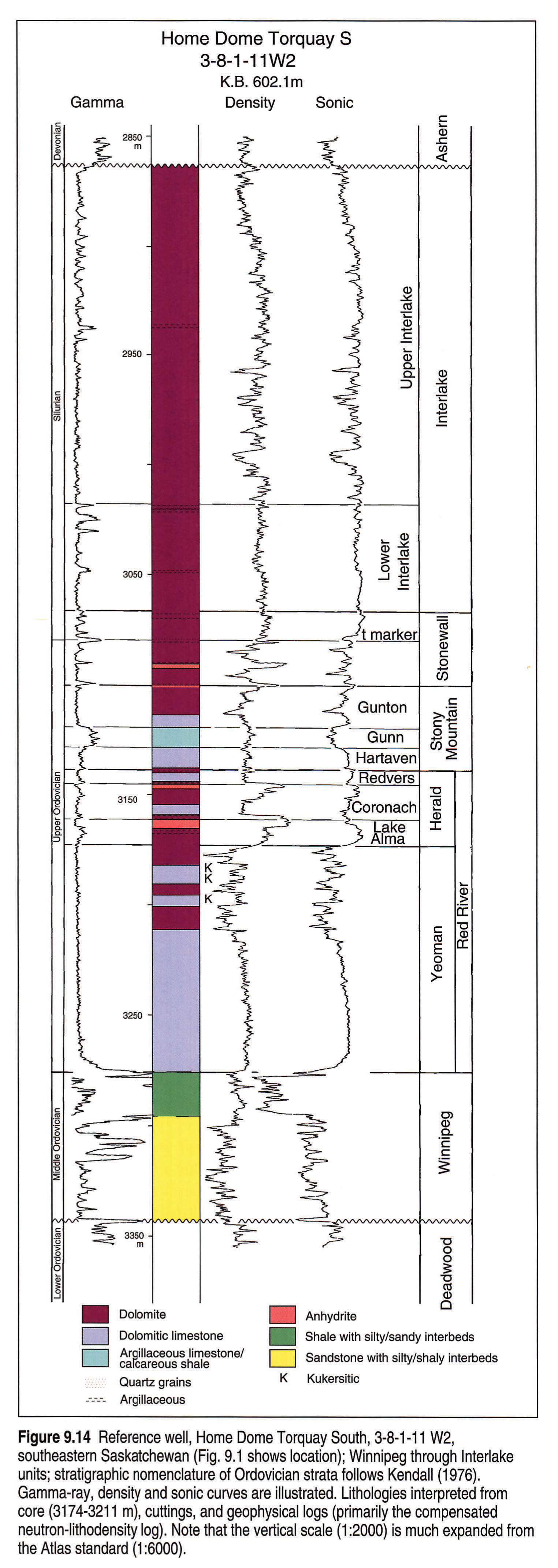
Figure 9.14 shows the geophysical log responses and lithologies for the Home Dome Torquay South 3-8-1-11W2 well in southeastern Saskatchewan. This well characterizes the Tippecanoe Sequence in an area where the depositional cycles seem to be most complete. Medium-to coarse-grained quartz sandstones of the lower part of the Winnipeg Formation unconformably overlie very fine- to fine-grained glauconitic sandstones of the uppermost Deadwood Formation. The upper 20 m of the Winnipeg Formation consists of dark greenish gray, waxy shales. These are overlain with apparent disconformity by burrow-mottled dolomitic limestones and dolomites of the Yeoman Formation (lower Red River). Of particular interest in this well are four thin beds of organic-rich laminites (kukersites) between 3182 and 3195 m in a core within the upper part of the Yeoman. This interval with kukersite beds can be correlated over a large part of the Williston Basin (Kendall, 1976; Haidl, 1990) and is the source rock for oil produced from Ordovician reservoirs and also from some younger reservoirs in the Williston Basin (Osadetz et al., 1992). The contact between the Herald and Yeoman formations is transitional but can be picked most consistently using the gamma-ray log to differentiate the clean carbonates of the Yeoman from the more argillaceous beds of the Herald. The bases of the Stonewall and Stony Mountain formations and of each member of the Herald Formation are placed at the bases of argillaceous and locally arenaceous dolomite marker beds that give high gamma-ray responses (Kendall, 1976). In the Stony Mountain Formation, the Gunn Member has a greater argillaceous content than the underlying Hartaven and overlying Gunton members and thus has a characteristic higher gamma-ray response. The top of the Stonewall Formation is picked at the top of a marker bed that commonly is less argillaceous and thicker than marker beds above and below. The Lake Alma, Coronach, and Gunton depositional cycles are capped by anhydrites, as is the lower cycle of the Stonewall. Two informal Interlake units, Lower and Upper, can be correlated with confidence on geophysical logs and are used in the regional cross sections. The top of the Lower Interlake is picked at the uppermost of a number of argillaceous marker beds (Fig. 9.14, gamma-ray log). The "v" marker of Porter and Fuller (1959, 1964) coincides with this marker in much of the area but locally seems to have been picked at a lower argillaceous marker. The top of the Lower Interlake falls below the top of the East Arm Formation of the Manitoba outcrops (Fig. 9.4). The remainder of the Interlake is difficult to subdivide with confidence using geophysical logs, and the Upper Interlake of the present chapter combines both the "Middle Interlake" and "Upper Interlake" of Porter and Fuller (1959, 1964). It includes the Cedar Lake Formation of the outcrop region and the subsurface determinations of Cedar Lake and Taylorton used by King (1964), Jamieson (1979) and Haidl (1987). The Cedar Lake-Taylorton contact can be picked only where core is available.
Williston Basin Cross Sections
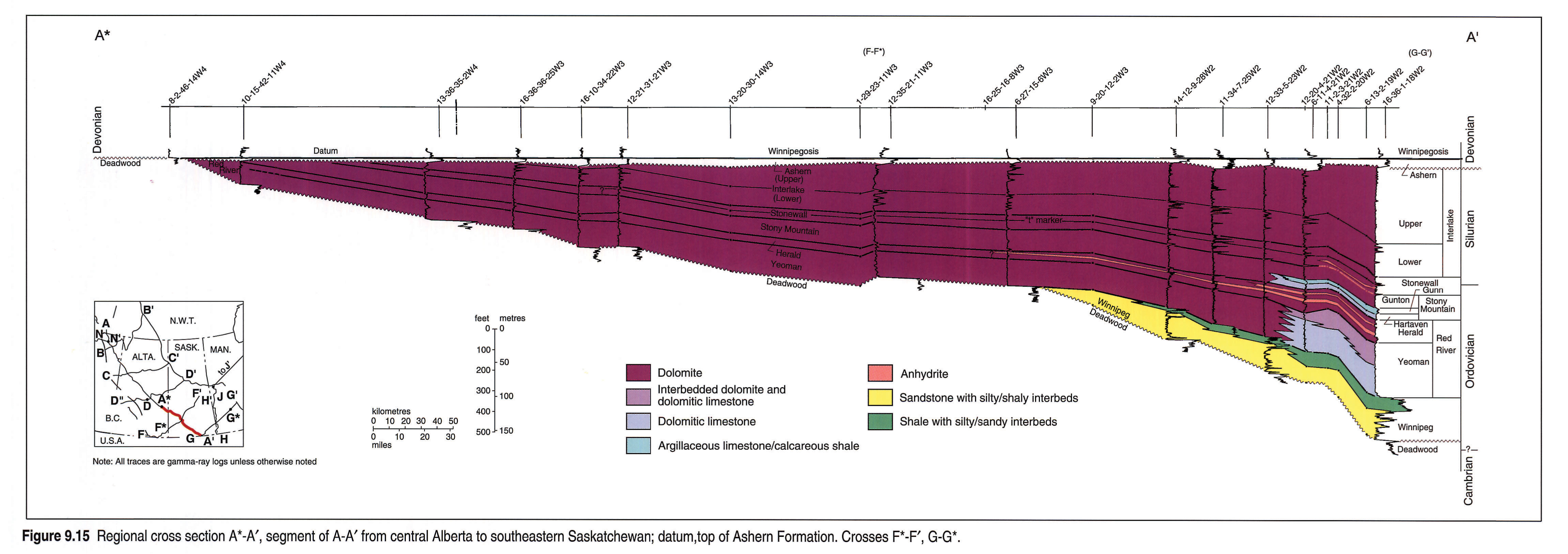
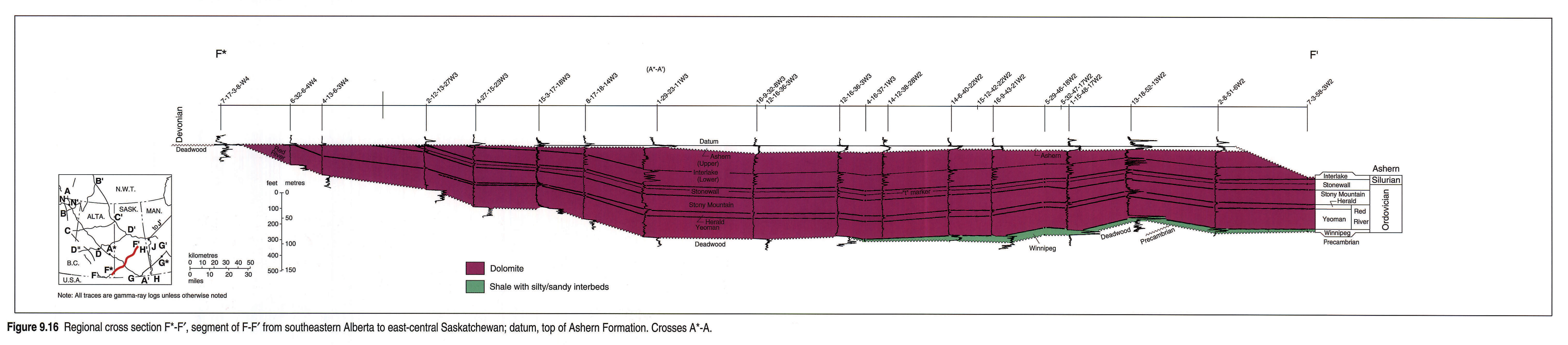
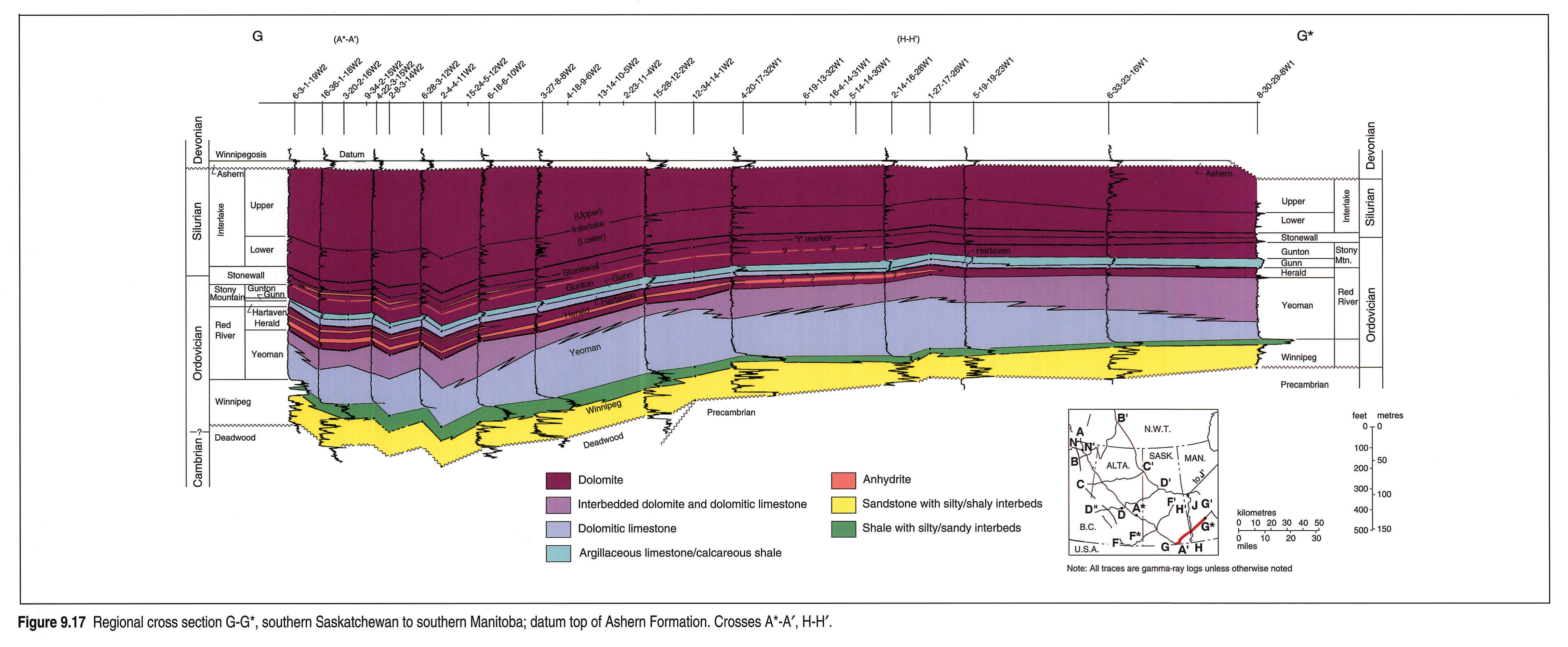
Four cross sections (A*-A', F*-F', G-G* and H-H'; Figs. 9.15, 9.16, 9.17, 9.18) illustrate the "layer cake" stratigraphy characteristic of most of the Tippecanoe Sequence of the Williston Basin. The argillaceous marker beds that define the lithostratigraphic units on gamma-ray logs can be traced across the basin but precision of correlation diminishes away from the central part of the basin where the depositional cycles are most complete. The top of the Ashern Formation (and its equivalent in Alberta) is chosen as the datum for these cross sections because it is easily correlatable by gamma-ray logs. However, the Ashern is absent on paleotopographic highs in the southwestern part of F*-F' and the top of the Tippecanoe Sequence is used as the datum. There and elsewhere, variations in Ashern thicknesses reflect the paleotopography of the sub-Ashern erosion surface. Infiltration of Ashern sediments into cavities of the karsted erosion surface can cause errors (generally less than 5 m) in picking the tops of the underlying Silurian or Ordovician carbonates. The local presence of anhydrites within the basal Ashern can lead to other difficulties in precisely picking the contact.
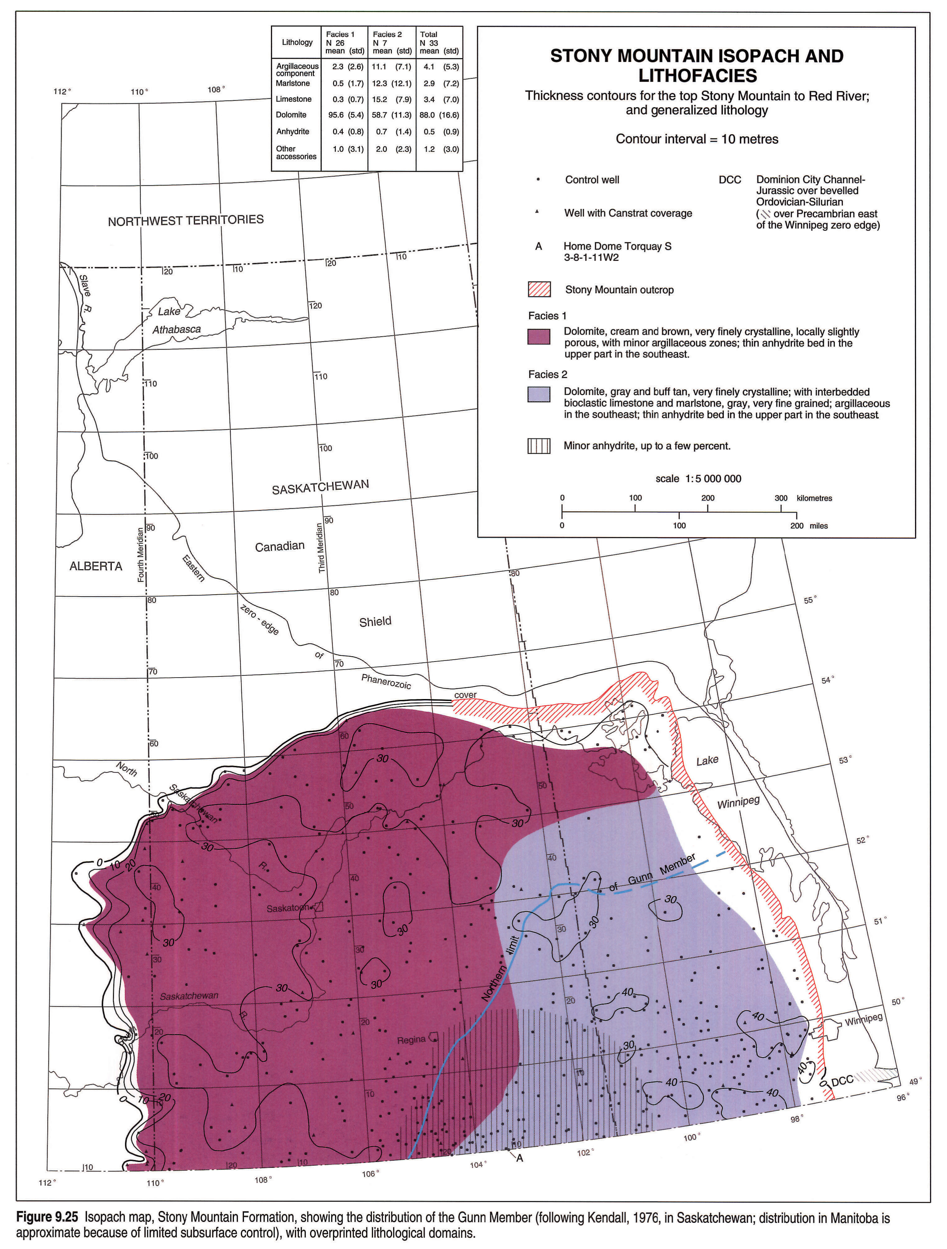
Lithologies portrayed on the cross sections have been interpreted from examination of geophysical logs, supplemented by sample and core data from a few wells. Dolomite is the dominant lithology within the sequence. Regional pervasive dolomitization appears to have been controlled by the distribution of the argillaceous carbonates of the Gunn Member of the Stony Mountain Formation (Kendall, 1976, 1989). Strata above the Gunn are dolomitized as is the entire carbonate part of the sequence outside the depositional limits of the Gunn (Figs. 9.14, 9.15, 9.16, 9.17, 9.18, 9.24, 9.25, 9.26). Dolomitization is not pervasive in the carbonates that underlie the Gunn Member (Figs. 9.14, 9.15, 9.17, 9.18) and the complex patterns of dolomitization within these strata have been attributed to a number of factors during multiple phases of dolomitization (Kendall, 1976; Kohm and Louden, 1978; Haidl, 1990).
A*-A' (Fig. 9.15) shows clearly the depositional and erosional thinning of stratigraphic units toward the Sweetgrass-Battleford and Peace River arches and away from the central part of the Williston Basin in southeastern Saskatchewan. The Winnipeg thins northwesterly from a succession (64 m thick) of basal sandstones and overlying shales to a thin sandstone unit (less than 2 m thick) that may represent an erosional remnant of the basal Winnipeg or reworked Winnipeg sand incorporated in the initial deposits of the Red River (Yeoman) transgression (Paterson, 1971; Kendall, 1976). To the northwest, beyond the limits of the Winnipeg subcrop, the Red River rests directly and unconformably on the Deadwood. Dolomitization of the Yeoman is most extensive beyond the depositional edge of the Gunn Member of the Stony Mountain (Kendall, 1976). The Herald thins depositionally to the northwest because of thinning of each of its carbonate-evaporite cycles away from the centre of the Williston Basin. The anhydrites within the Herald, Stony Mountain and Stonewall are present only in the southeast half of A*-A'. The extreme southeast end also shows subdivision of the Stony Mountain into its three members. Beyond the depositional limits of the argillaceous limestones of the Gunn Member (which thus change facies into nonargillaceous carbonates), the Hartaven and Gunton members cannot be separated. The Stonewall and Lower Interlake both contain numerous argillaceous marker beds. Correlation of these marker beds, including the "t" marker, becomes difficult toward the edges of the subcrop. Several argillaceous horizons are present within the Upper Interlake but their correlation is equivocal. In core from the 6-13-2-19W2 well, the contact between the Cedar Lake and Taylorton units (both Upper Interlake of the present terminology) is an erosional surface between dark grayish brown Cedar Lake dolomite and yellowish gray brecciated Taylorton dolomite that contains large clasts of dolomite derived from the Cedar Lake.
The southeastern segment (11-34-7-25W2 to 16-36-1-18W2) of A*-A' and the southwestern part of G-G* are within the Roncott High-Hummingbird Trough area where episodic Phanerozoic movements of Precambrian structural blocks influenced patterns of sedimentation, erosion, dolomitization and salt dissolution (Haidl, 1990; Kent and Christopher, this volume, Chapter 27) An example of such influence is at the Mark et al. Minton 11-2-3-21W2 well. Located on a small structural high, this well has anomalously thin Ashern and Upper Interlake units and good intercrystalline porosity is developed within the Yeoman Formation. The Minton well has produced more than 20 000 m3 of oil from the Yeoman. Oil derived from Ordovician rocks also is produced from a reservoir within the Devonian Winnipegosis Formation.
F*-F' (Fig. 9.16) crosses the northern part of the Williston Basin from a southwestern erosional feather-edge of the Tippecanoe Sequence and continues into outcrop near Cumberland Lake in the northeast. It lies beyond the depositional limits of the evaporite units (Fig. 9.13) and of the Gunn Member of the Stony Mountain, which thus cannot be subdivided into members. Southwestward erosional thinning below the Devonian is shown. The Winnipeg is present only in the northeast as less than 10 m of shale with interbedded siltstones and sandstones overstepping the eastern limit of the Deadwood; it is itself overstepped by the Yeoman in west-central Saskatchewan. The Herald cannot be discriminated as a discrete unit west of 4-27-15-23W3. Stratigraphic correlation of lowermost Kaskaskia and uppermost Tippecanoe strata in Saskatchewan wells west of 1-29-23-11W3 indicates that a shale previously placed in the Ashern should be assigned to the Winnipegosis. This revision is based on studies of core and conodont biostratigraphic data (T.T.Uyeno, pers. comm.) from the B.A. Hatton 2-12-13-27W3 well.
G-G* (Fig. 9.17) extends from the central Williston Basin to near the Manitoba outcrops and shows the eastern limit of the Deadwood, with the overlying Winnipeg overstepping onto Precambrian rocks. Variations in thickness of the Gunn Member of the Stony Mountain reflect the westerly and northerly facies changes of this unit into the less argillaceous carbonates of the Hartaven Member, but the line of section is oblique to the directions of these changes of facies (Fig. 9.25). The anhydrites within the Herald, Stony Mountain and Stonewall disappear northeastward away from the central part of the Williston Basin.
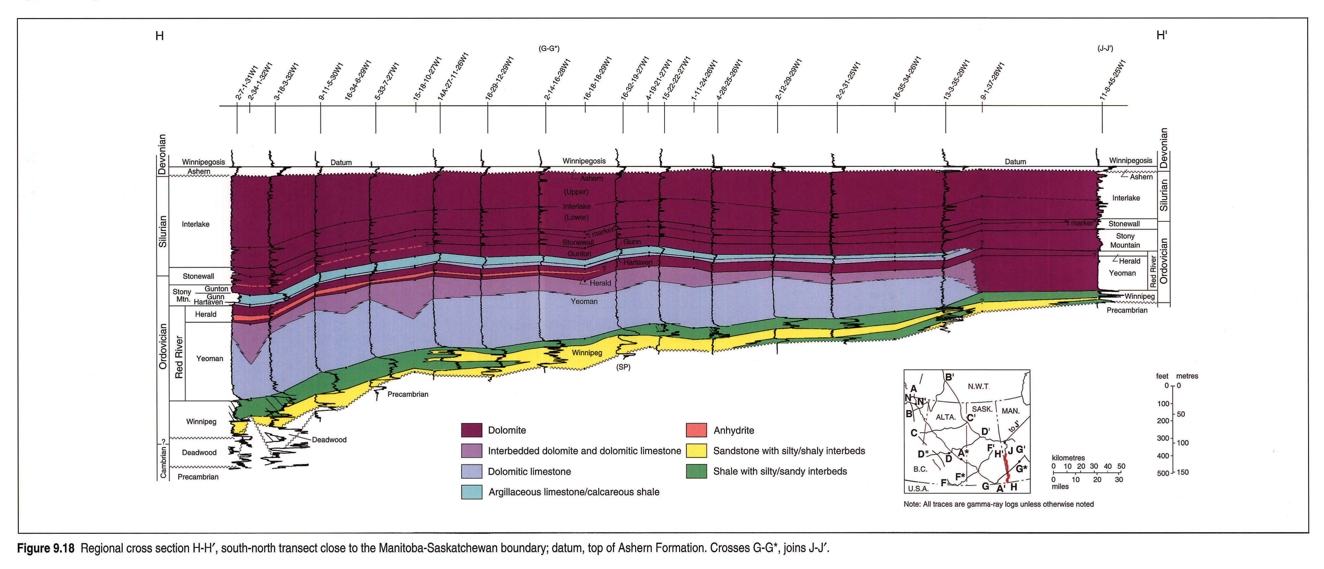
H-H' (Fig. 9.18) essentially follows the Manitoba-Saskatchewan boundary. The Deadwood is present only in the extreme south, close to its erosional edge. The Winnipeg thickens southward and its shale component increases. The Yeoman also thickens southward toward its depocentre in North Dakota. Some similar depositional thickening also occurs within the Herald and Stonewall and may be present in the Upper Interlake, but the lack of marker beds in the Upper Interlake makes it difficult to differentiate any such thickening from the effects of erosional truncation of the unit (Kent and Christopher, this volume, Chapter 27). Within the Stony Mountain, a facies change near 13-3-35-29W1 from argillaceous limestones and calcareous shales (Gunn Member) to nonargillaceous limestones precludes subdivision of the Stony Mountain into members north of this well. The anhydrites within the Herald and the Stony Mountain are present only at the southern end of H-H'. An anomalous sequence is present in the Cherokee et al. Workman 2-34-1-32W1 well, which is located on a Precambrian high. The Deadwood is absent and the Winnipeg is considerably thinned with loss of most of its lower sandstones. Core from this well shows faulting in strata below the Lake Alma Anhydrite (Herald Formation).
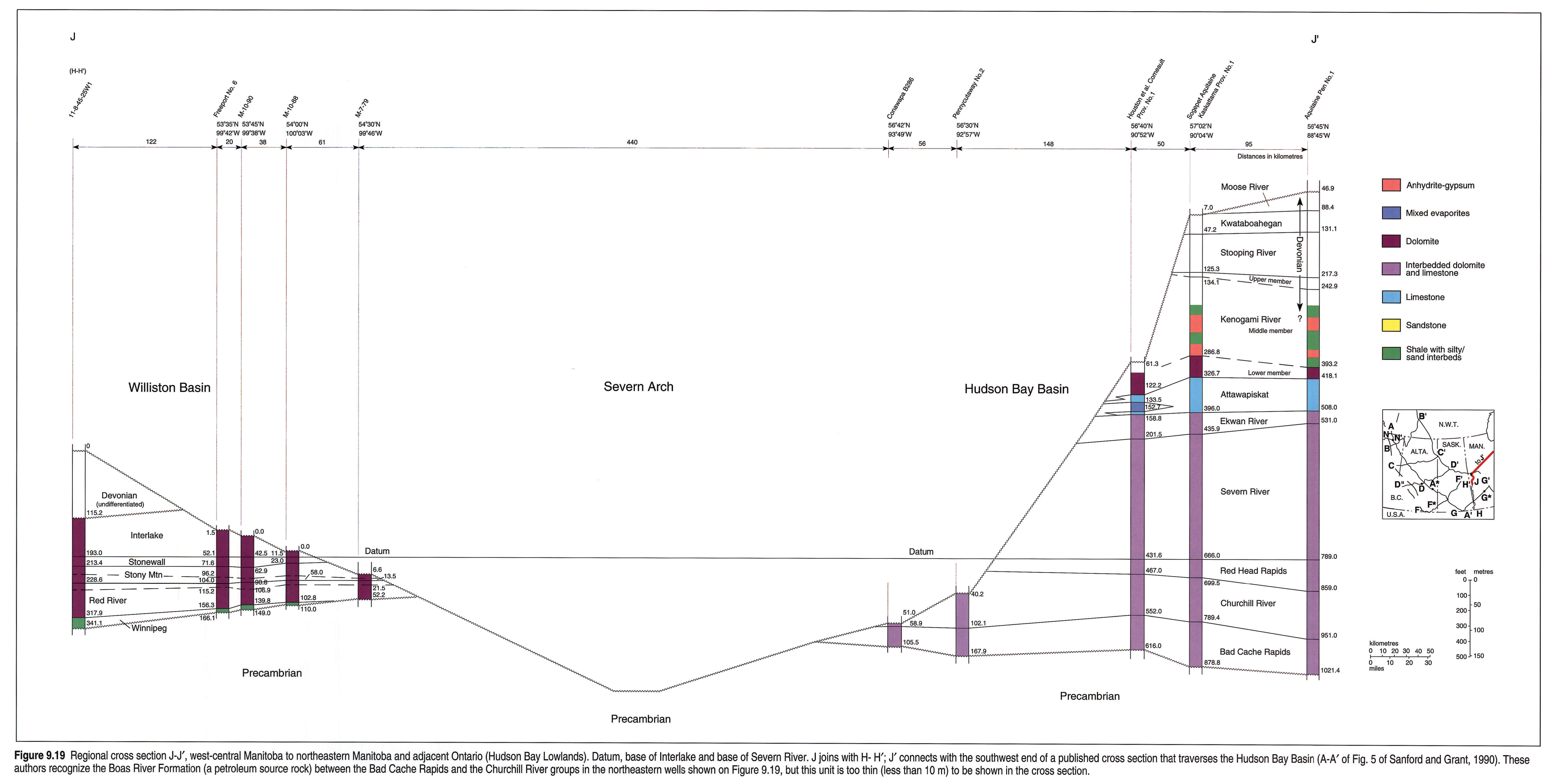
J-J' (Fig. 9.19) shows the close resemblance between the stratigraphic units in the Williston Basin and the Hudson Bay Basin, indicating that many of them were depositionally continuous. The Red River and the Bad Cache Rapids are broadly equivalent, as are the Stony Mountain and the Churchill River, the Stonewall and the interval designated Red Head Rapids, much of the Lower Interlake and the Severn River. In southern Manitoba, the Winnipeg is overlapped by the Red River northward and does not extend into the Hudson Bay Basin although basal sandstones are present within the Bad Cache Rapids. There is no equivalent of the Upper Silurian and Lower Devonian components of the evaporitic Kenogami River in the Williston Basin. The Red River to Interlake interval is at least twice as thick in the Hudson Bay Basin as in the Williston Basin.
Systemic Boundaries
Precise location of the Ordovician-Silurian boundary is difficult in the mountain outcrops, because of the poorly fossiliferous strata of the boundary interval. In the southern Rocky Mountains, it can only be positioned within a 75 m interval of the Beaverfoot Formation (Norford, l988). In the subsurface of the Williston Basin, the boundary traditionally has been picked at the t-marker within the upper part of the Stonewall Formation (Porter and Fuller, 1959; Brindle, 1960; McCabe, l988). Using both corals and conodonts, recent biostratigraphic studies confirm this as an approximate placement, both in outcrop (Cormorant Hill roadcut) and in the subsurface (Esterhazy 3SWD well, 16-26-20-33W1, Haidl, 1991; diamond drillhole at Warren near Stonewall; Bezys, 1991).
Details of the Silurian-Devonian boundary are poorly known. Relevant strata are preserved only in the northwestern part of the Atlas area, where the boundary lies somewhere within the virtually unfossiliferous Muncho-McConnell Formation of the MacDonald Platform and within the SD Unit of the Road River Group of the Kechika Trough.
Structure
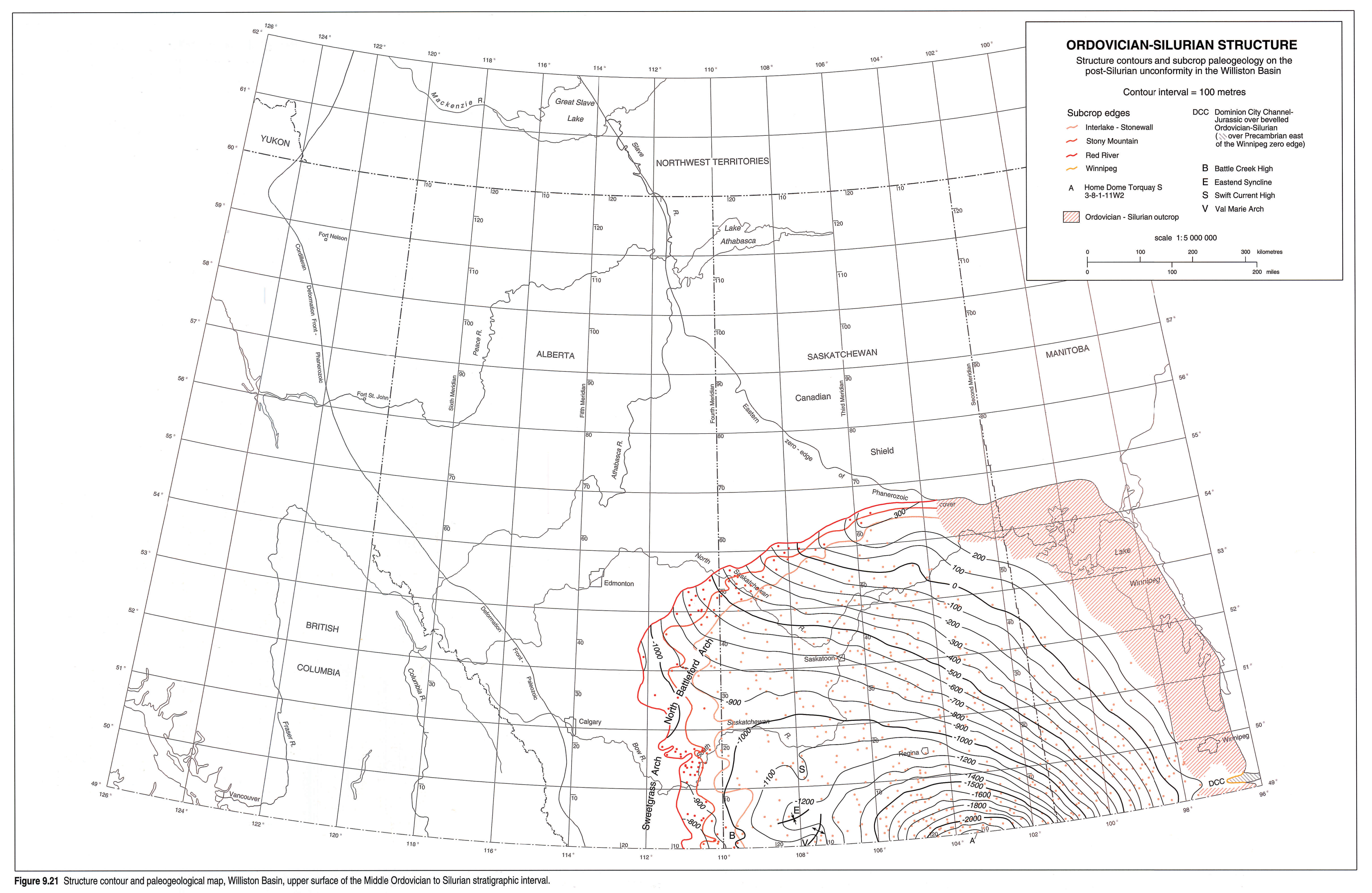
Figures 9.1, 9.2, and 9.21, 9.22 clearly show the limited subsurface extent of the stratigraphic package. The cross sections (Figs. 9.5, 9.6, 9.7, 9.8, 9.9, 9.10, 9.11, 9.12 left pane, 9.12 right pane, 9.15, 9.16, 9.17, 9.18, 9.19) demonstrate feather-edges of rock units where they are truncated beneath Devonian and younger unconformities. Similar relations are shown for several units below unconformities within the Middle Ordovician to Lower Devonian interval (Figs. 9.6, 9.7, 9.11, 9.12 left pane, 9.12 right pane).
In the Williston Basin area, contours on the eroded top of the Tippecanoe Sequence (Fig. 9.21) show a general southwesterly dipping surface on which is imposed the somewhat asymmetrical influence of the structural Williston Basin (note the -1000 m contour in Fig. 9.21). The Sweetgrass-North Battleford Arch forms the west flank of the basin and trends north-northeast; the east flank is against the Severn Arch that trends north-northwest (Fig. 9.2). Some local structures affect the smoothness of the structural pattern. In southwestern Saskatchewan these include the Val Marie Arch (a northern extension of the Bowdoin Dome), the Battle Creek High, the Swift Current High, and the Eastend Syncline (Fig. 9.21; Kent and Christopher, this volume, Chapter 27). In Manitoba, the Tippecanoe strata are disrupted by three structures that possibly were caused by meteorite impacts: the Hartney Structure in the subsurface (McCabe, 1982) and the Lake St. Martin and High Rock Lake structures in the outcrop belt (Fig. 9.22; McCabe and Bannatyne, 1970; McCabe, 1982).
The paleogeology of the post-Tippecanoe erosion surface reflects the topographic patterns developed during the pre-Kaskaskia hiatus. Many of these patterns were inherited from Precambrian structural features that had persistent effects through much of Paleozoic time, such as the Peace River, Mackenzie, and Sweetgrass-North Battleford arches. The Meadow Lake Escarpment was an Early Devonian erosional feature and forms much of the present northern limit of the Tippecanoe Sequence of the Williston Basin (Fig. 9.2). Near the feather-edge of the subcrop in southeastern Alberta, isopach patterns indicate that Early Devonian valleys cut into the Tippecanoe Sequence. Pre-Jurassic and pre-Cretaceous erosion locally affected Tippecanoe strata in parts of Manitoba and Saskatchewan; for example, south of Winnipeg, the "Dominion City Channel" was eroded into and through the Tippecanoe Sequence and later was filled with Jurassic sediments, causing an area of east-west thinning shown by the isopach maps (Fig. 9.23 etc.). The course of the remainder of the eastern edge of outcrop reflects erosional truncations that were associated with later episodes of uplift of the Severn Arch and the Transcontinental Arch and with movements along faults documented in Precambrian rocks adjacent to the edge. Figure 9.19 indicates that the Tippecanoe Sequence originally was continuous across the Severn Arch from the Williston Basin to the Hudson Bay Basin.
In the Rocky Mountains and in the southern District of Mackenzie, Middle Ordovician to Lower Devonian strata are restricted largely to the disturbed belt, with Mesozoic and Cenozoic thrusts obscuring any earlier structures. However, east of the Rocky Mountains, several positive areas (Fort Nelson High, Peace River Arch) strongly influenced Cambrian and Middle and Late Devonian sedimentation on the craton. Doubtless such areas also had influence during Middle Ordovician to Early Devonian time but very little of the effects are preserved in the stratigraphic record (Norford, 1991; Cecile and Norford, in press).
Isopach Maps
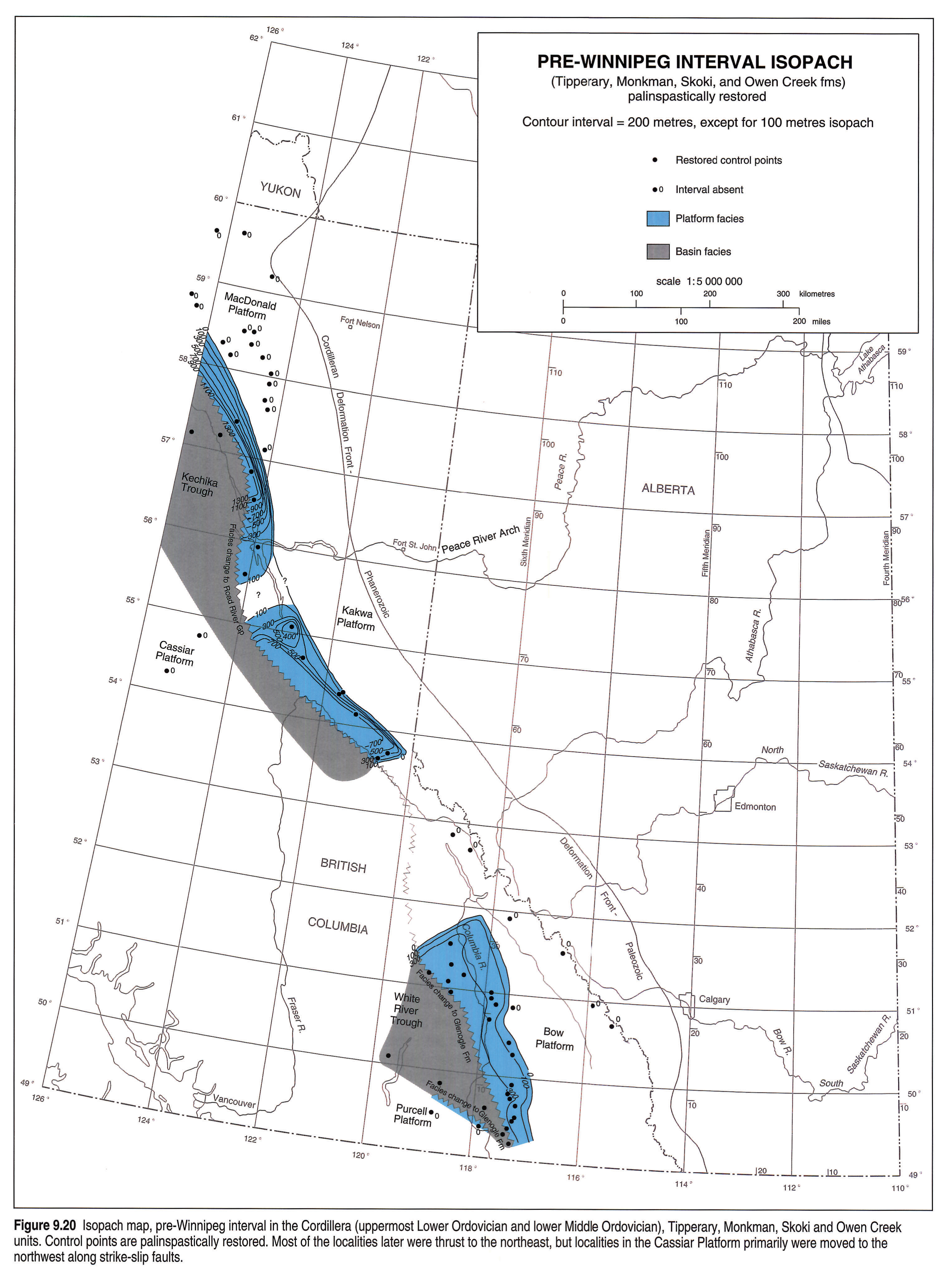
The pre-Winnipeg part of the stratigraphic interval is preserved only in the mountains (Fig. 9.20) because of erosion associated with later unconformities. Westward the interval is represented by the Glenogle and Road River units of basinal facies. The isopach pattern in the Bow Platform primarily results from later Ordovician erosion, but a southern bulge reflects thickening caused by the local presence of Tipperary sands. Similarly, Monkman sands locally thicken the interval in a part of the Kakwa Platform. The intense thickening of the interval westward and southward of the Kakwa and MacDonald platforms seems to be due to substantial thickening of the Skoki Formation at the outboard edges of the platforms combined with the post-Skoki unconformity rising in the same areas to allow preservation of younger Skoki rocks.
In the Canadian part of the Williston Basin the Tippecanoe Sequence reaches a maximum thickness of 478 m (Fig. 9.2), almost half of which consists of the Stonewall and Interlake units. The dominating influence of these two units on the isopachs decreases away from the central part of the basin as they are truncated by the sub-Kaskaskia unconformity. However, the depositional basin doubtless extended much farther eastward and connected with the Hudson Bay Basin. The major paleotopographic feature on the pre-Kaskaskia surface was the Meadow Lake Escarpment, which was formed by differential erosion of the resistant Ordovician carbonates and the underlying clastics of the Sauk Sequence. South of the escarpment, the surface was essentially flat with the exception of paleotopographic elevations associated with the Swift Current Platform and the Sweetgrass Arch and local elevations and depressions related to Precambrian structures.
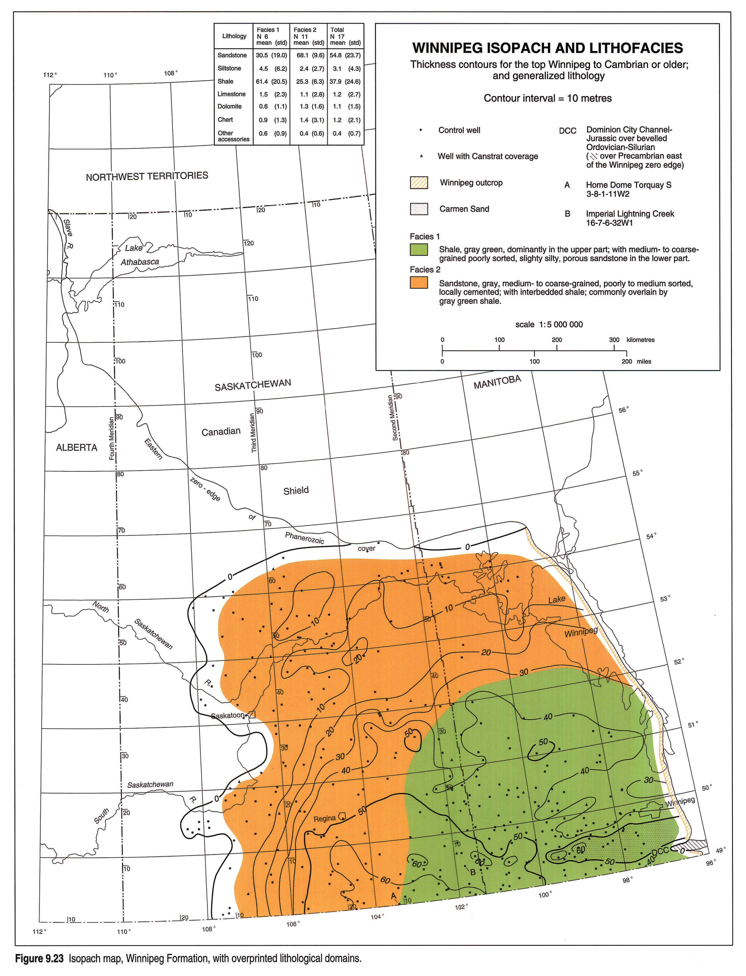
The Winnipeg Formation (Fig. 9.23) reaches a thickness of 105 m (Kessler, 1991) at its depocentre in North Dakota but its maximum thickness in Canada is 68 m. Paleotopography and syndepositional tectonic activity related to Precambrian basement features such as the Churchill-Superior Boundary Zone (Fig. 9.22) and local highs (e.g., at 2-34-1-32W1; Fig. 9.18) and differential compaction of muds relative to sands contributed to local variations in Winnipeg thicknesses (McCabe, 1967, 1978; Paterson, 1971; Vigrass, 1972). The distribution of the Winnipeg and variations in its thicknesses near its western limit have been attributed to sub-Yeoman erosion (Paterson, 1971), depositional thinning (Vigrass, 1972) and assignment to the Winnipeg Formation of sands reworked from Winnipeg subcrop into the basal Yeoman Formation (Kendall, 1976). The complete absence of the Winnipeg in the Imperial Lightning Creek 16-7-6-32W1 well is an anomaly that has been explained by faulting (Kendall, 1976). The eastern limit of the Winnipeg is a feature of post-Tippecanoe erosion and the northeastern edge of the Winnipeg Formation is due to overlap by the Red River Formation.
The distribution of lithologies within the Winnipeg Formation (Fig. 9.23) shows a decrease in the sandstone/shale ratio toward the basin centre from Facies 2 to Facies 1. Paucity of Canstrat data does not allow definition on this lithology map of the east-west-trending sand body, the "Carman Sand", outlined by the 50 m isopach south of the City of Winnipeg (see Kessler, 1991, for discussion of the deposition of this and other elongate sand bodies within the Winnipeg).
Because of the limits of refined picks in the database, the Red River isopach map (Fig. 9.24) combines both the Herald and the Yeoman, although Kendall (1976) gave separate maps for part of the region. The Yeoman is much thicker than the Herald and thus has stronger influence on the isopach map of the total Red River. The map shows depositional thinning away from the centre of the Williston Basin and erosional truncation near the subcrop edge and the outcrop edge. The northwestern edge of the Red River is at the Meadow Lake Escarpment. Local thinning is evident southwest of Winnipeg (closed 150 m isopach) and reflects a paleotopographic high caused by differential compaction of the underlying Carman Sand of the Winnipeg Formation compared to the surrounding shales. Local depositional thinning also occurs in the Swift Current area, associated with a Precambrian structure that also influenced sedimentation at other times during the Phanerozoic (Kent and Christopher, this volume, Chapter 27). Two anomalies that conflict with the regional distribution are indicated in Figure 9.24. The Red River, Stony Mountain and Stonewall are absent in the Dome Provost 11-8-36-2W4 well (C on Fig. 9.24) and paucity of data northwest of the locality prevents decision on whether this is an isolated anomaly or whether it is within a narrow northwest-trending Devonian paleovalley that cut through the Ordovician succession. The Red River is anomalously thick (215.5 m) in the Imperial Lightning Creek 16-7-6-32W1 well (B,Fig. 9.24) where Kendall (1976) suggested repetition by faulting.
The boundary between the two lithological domains within the Red River (Fig. 9.24) reflects the amount of dolomitization within the Yeoman Formation. This in turn appears to have been controlled by the distribution of the Gunn Member of the Stony Mountain, which, where present, sheltered the underlying Yeoman from Mg-rich fluids (Kendall, 1976, 1989; Figs.9.24 , 9.25). Anhydrites reported in the sampled cuttings are from the Lake Alma and Coronach anhydrite beds within the Herald Formation (Fig. 9.13).
In general, thicknesses of the Stony Mountain Formation range between 25 and 45 m, except for the erosional truncations close to its subcrop and outcrop edges (Fig. 9.25) and the absence of the Stony Mountain from the Dome Provost 11-8-36-2W4 well (see earlier discussion of absence of the Red River). The distribution of the lithological domains is controlled primarily by the thicknesses of argillaceous carbonates and shales of the Gunn Member, although the boundary shown between the two domains lies partially to the east of the limit of the Gunn. The thickest development (45 m) of the Stony Mountain Formation in southern Manitoba coincides with the area of highest shale content within its Gunn Member, and the actual amount of thickening of the formation toward the centre of the basin may have been subdued by the degree of compaction of these shales. Anhydrites reported in the sampled cuttings are from a thin anhydrite bed at the top of the Stony Mountain (Figs 9.13, 9.25).
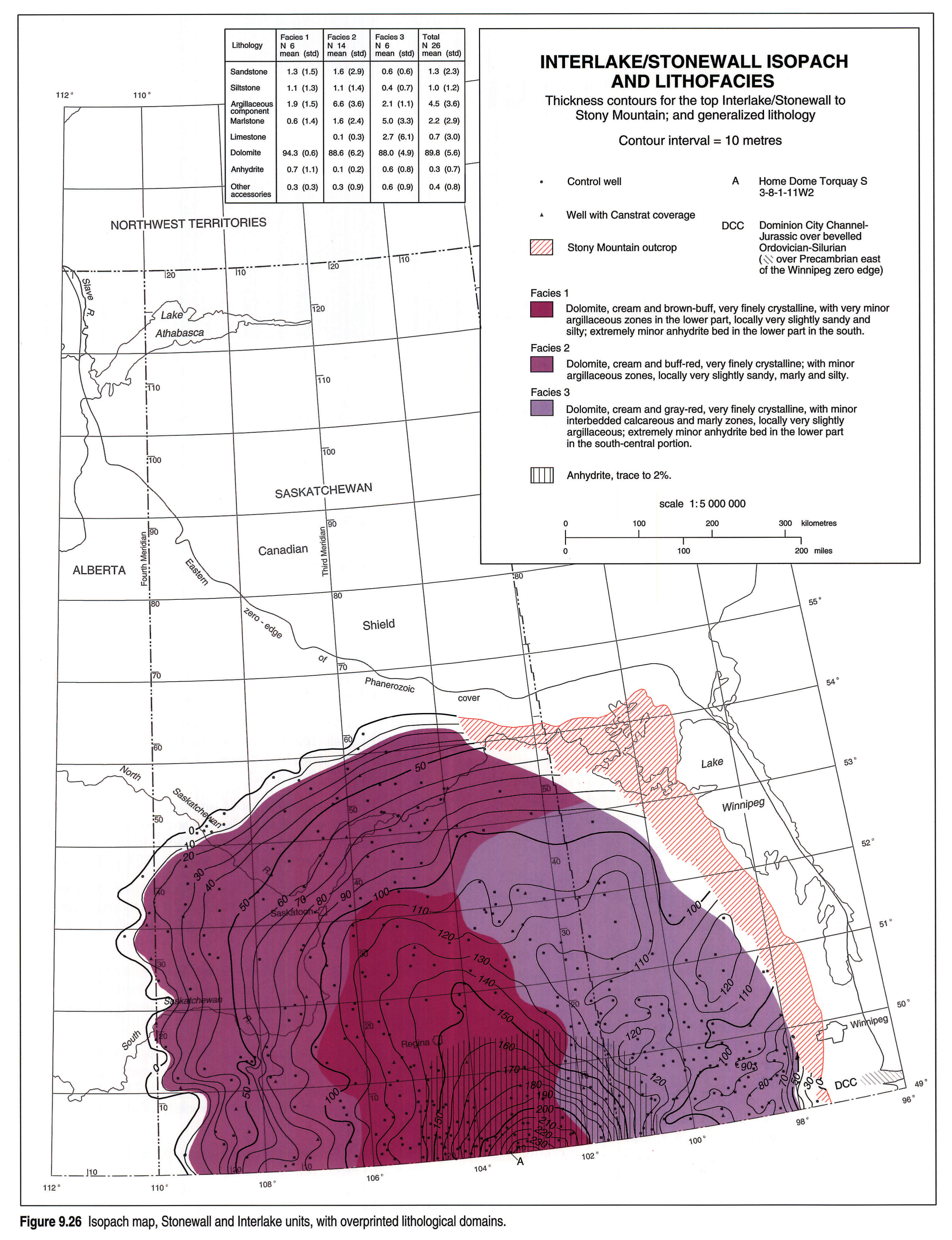
For the combined interval, Stonewall Formation and Interlake Group, the isopach map reflects both depositional thickening toward the centre of the Williston Basin and erosional truncation associated with the sub-Kaskaskia unconformity. Maximum thicknesses are almost 250 m in southeastern Saskatchewan and about 370 m in North Dakota. The isopach patterns indicate a westward shift of the depocentre of the basin from its position during Red River time (Figs. 9.24, 9.26). This shift was indicated by similar isopach patterns shown by Porter and Fuller (1964, Fig. 4-8) for their "Lower Interlake" unit in the areas where it was not affected by pre-Kaskaskia erosion. The north-trending thinning near 52°N, 103°W is on trend with the Tabbernor Fault Zone (Fig. 9.22; Kent and Christopher, this volume, chapter 27) and farther north along the trend, a tectonic breccia in core from the Yeoman Formation in the Cominco SR1 drillhole (just south of 54°N) documents Paleozoic movement along this fault zone (Haidl, 1988). The interval is absent in the Dome Provost 11-8-36-2W4 well (see earlier discussion of absence of Red River).
Dolomite is the dominant lithology of the Stonewall-Interlake interval. The lithological domains (Fig. 9.26) primarily reflect decreases in thickness of the Upper Interlake (virtually entirely dolomite) by erosional truncation, thus proportionally increasing the argillaceous components from the argillaceous marker beds within the Lower Interlake and the Stonewall (Facies 2). Facies 3 indicates the presence of beds of calcareous dolomite. Anhydrites reported in the sampled cuttings are primarily related to the distribution of a thin anhydrite bed that caps the lowest depositional cycle in the Stonewall Formation.
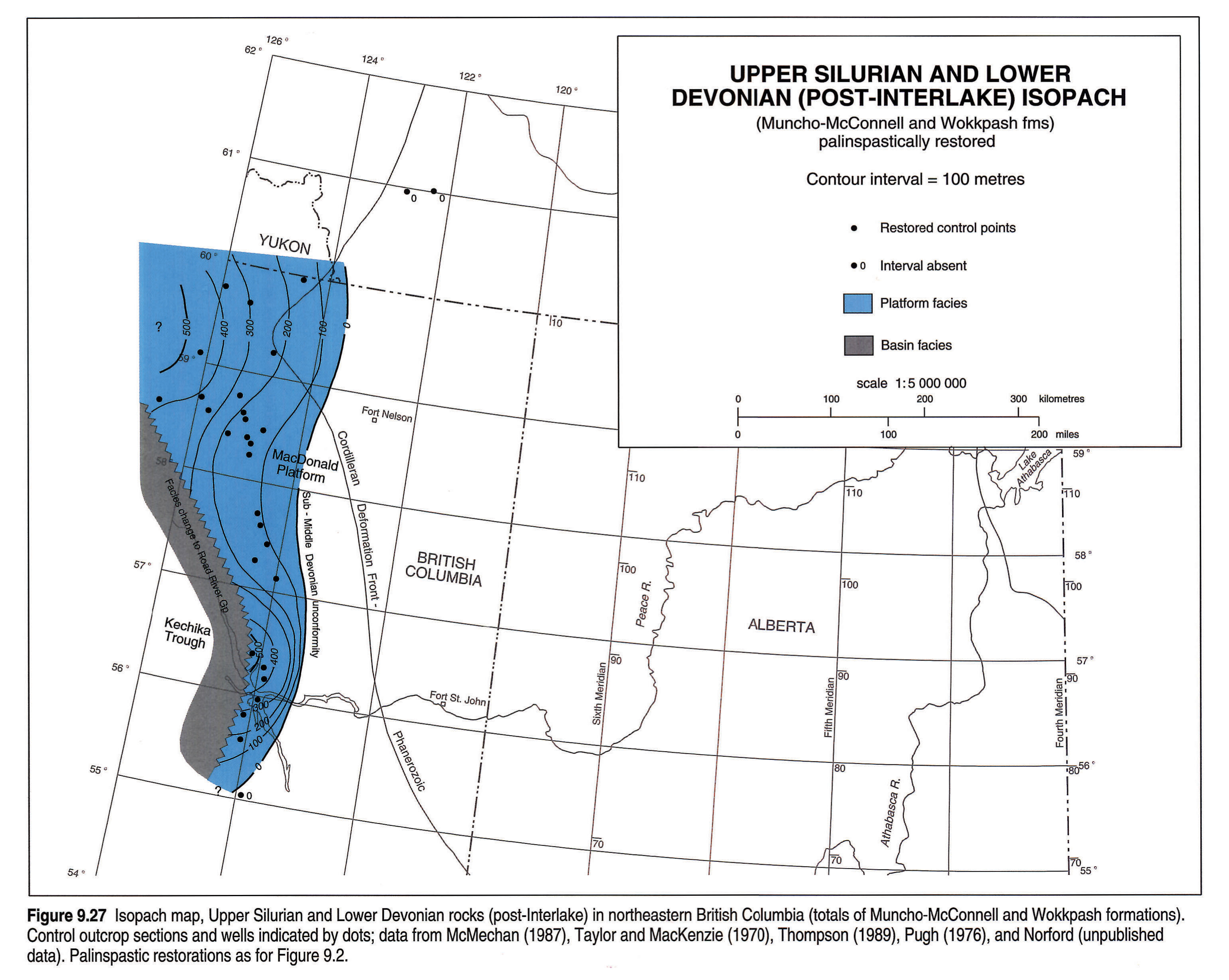
Upper Silurian and Lower Devonian rocks are preserved only in northeastern British Columbia and the adjacent District of Mackenzie. Figure 9.27 shows the regional pattern of westward depositional thickening of the platform carbonates and quartz sandstones of the Muncho-McConnell and Wokkpash formations, modified by abrupt facies changes into coeval parts of the Road River Formation.
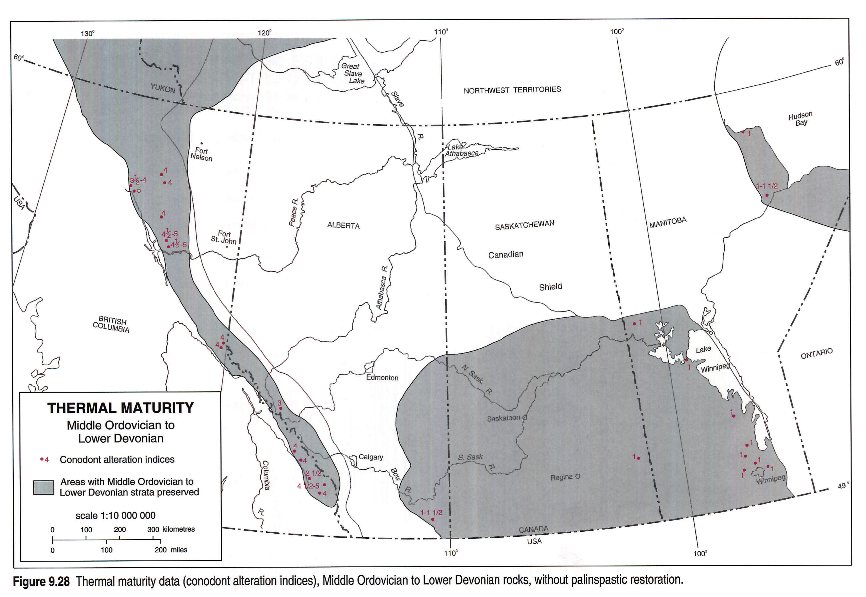
Thermal Maturity and Resources
Thermal maturities are too high throughout the Rocky Mountains for preservation of petroleum or gas (Fig. 9.28). They are lower in the southern part of the Mackenzie Platform but the feather-edge of the Mount Kindle Formation only just reaches the Atlas area (Fig. 9.11). Dolomites and quartz sandstones of the Nonda Formation extend some distance east from the northern Rocky Mountains within the subsurface of northern British Columbia (Fig. 9.9) but thermal maturities are high in the adjacent outcrops.
Thermal maturities are much lower in the Manitoba outcrops and in the subsurface of the southern Plains (Fig. 9.28) with some of the Ordovician and Silurian formations locally being within the wet gas and oil windows (Osadetz and Haidl, l989), developed at abnormally low-temperature levels because of the special character of the source rocks, kukersites. Minor oil shows have been known for many years in the lower Paleozoic rocks of Manitoba, and petroleum has been produced in small amounts from the Red River Formation of southern Saskatchewan. Extensive production has been achieved from locations in Montana and North Dakota where the exploration parameters are very similar, but structures have had a larger effect and burial seems to have been greater than in Saskatchewan (Longman et al., 1992). Recent exploration in the Minton area of southeastern Saskatchewan has resulted in significant discoveries (Potter and St. Onge, 1991). These and older wells elsewhere in Saskatchewan have yielded cumulative production of 140 000 m3 (880 600 bbls.) of Red River-sourced oil in Red River and Winnipegosis (Devonian) reservoirs to the end of June, 1991. The oil may have migrated northward from more mature Red River rocks in the adjacent United States.
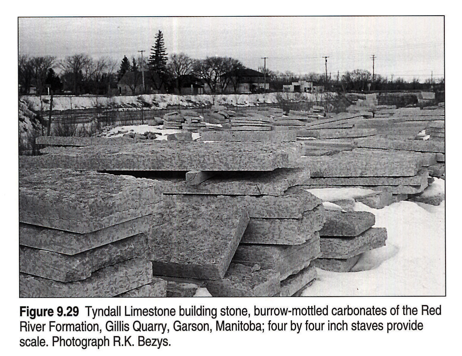
The carbonate rocks in the Manitoba outcrops have been extensively used as a source for crushed stone. Major operations quarry the Stonewall and Stony Mountain formations north of Winnipeg and quarries in the Interlake Group function intermittently. Because the rocks are dominantly dolomites and argillaceous dolomites, there has been no production for cement. Interlake dolomites at Hilbre (210 km north of Winnipeg) have been used as a source of dolomitic lime for agriculture. For nearly a hundred years, rock of the Red River Formation (Selkirk Member) has been used as an ornamental building stone (Tyndall Stone, Fig. 9.29). Tyndall Stone graces several provincial legislatures, the Parliament Buildings in Ottawa, the Museum of Civilization in Hull, and many other public and commercial buildings across Canada. The prime source is the Gillis Quarry at Garson (40 km northeast of Winnipeg).
Silica sand from the Winnipeg Formation is extracted at Black Island (Lake Winnipeg) and used as a foundry sand. It has been used for glass manufacture and has the potential to be a source for silicon metal. In the Rocky Mountains (Fig. 9.30), the Mount Wilson Quartzite is quarried as a glass sand, for other industrial uses that include the manufacture of silicon, and for lining bunkers on golf courses. Production from the two active quarries totalled 126 000 tonnes in 1990 (Butrencuk, 1991). Base metal mineralization is present in the Muncho-McConnell Formation (Thompson, 1989).
Acknowledgements
The present synthesis builds from the published work of many scientists, from the data files of federal and provincial agencies, and from the stratigraphic picks of countless geologists who have logged wells in Western Canada. Special appreciation is expressed to Shell Canada Limited (particularly Bob McMechan and Peter Fermor) for calculations made of palinspastic restorations for the sites of many of the outcrop locations and well sites within the southern Rocky Mountains; M.P. Cecile provided the palinspastic restorations for the other regions. Jim Podruski kindly made available information from his studies of the Paleozoic rocks of the subsurface of southeastern Alberta; B.V. Sanford provided data from his detailed studies of three wells in northern Manitoba and adjacent Ontario. G.S. Nowlan and T.T. Uyeno provided important age determinations using conodonts.
References
- Baillie, A.D. 1951. Silurian geology of the Interlake areas, Manitoba. Manitoba Department of Mines, Publication 50-1.
- Baillie, A.D. 1952. Ordovician geology of Lake Winnipeg and adjacent areas, Manitoba. Manitoba Department of Mines, Publication 51-6.
- Bezys, R.K. 1991. Stratigraphic mapping (NTS 63F, 63K) and core hole program 1991. Manitoba, Energy and Mines, Minerals Division, Report of Activities, 1991, p. 61-73.
- Butrenchuk, S.R. 1991. Geological setting and development and potential of selected industrial minerals in southeastern British Columbia. British Columbia, Geological Survey Branch, Open-File 1991-23, p. 37-43.
- Cecile, M.P. 1989. An inventory of Canadian Ordovician reefs and organic buildups. In: Reefs, Canada and Adjacent Areas. H.H. Geldsetzer, N.P. James, and G.E. Tebbutt (eds.). Canadian Society of Petroleum Geologists, Memoir 113, p. 171-176.
- Cecile, M.P. and Norford, B.S. 1979. Basin to platform transition, lower Paleozoic strata of Ware and Trutch map-areas. In: Current research, Part A, Geological Survey of Canada, Paper 79-1A, p. 219-226.
- Cecile, M.P. and Norford, B.S. (in press). The Ordovician and Silurian of Western Canada. In: Geology of Canada (7th edition), no. 5, J.D. Aitken and D.F. Stott (eds.), Geological Survey of Canada.
- Gerhard, L.C. and Anderson, S.B. 1988. Geology of the Williston Basin (United States portion). In: Sedimentary Cover - North American Craton: U.S. L.L. Sloss (ed.). Decade of North American Geology, Geological Society of America, v. D-2, p. 221-241.
- Haidl, F.M. 1987. Stratigraphic and lithologic relationships, Interlake Formation (Silurian), southern Saskatchewan. Saskatchewan Energy and Mines, Miscellaneous Report 87-4, p. 187-193.
- Haidl, F.M. 1988. Lithology and stratigraphy of Lower Paleozoic strata, new information from cores in the Cumberland Lake area, east-central Saskatchewan. Saskatchewan Energy and Mines, Miscellaneous Report 88-4, p. 202-210.
- Haidl, F.M. 1989. Distribution of Lower Paleozoic strata in the vicinity of the Meadow Lake Escarpment, west-central Saskatchewan. In: Summary of Investigations 1989, Saskatchewan Energy and Mines, Miscellaneous Report 89-4, p. 125-132.
- Haidl, F.M. 1990. Ordovician hydrocarbon reservoirs, Herald and Yeoman formations (Red River), southeastern Saskatchewan. Saskatchewan Energy and Mines, Miscellaneous Report 90-4, p. 176-186.
- Haidl, F.M. 1991. Note on Ordovician-Silurian boundary in southeastern Saskatchewan. Saskatchewan Energy and Mines, Miscellaneous Report 91-4, p. 205-207.
- Jamieson, E.R. 1979. Well data and lithologic descriptions of the Interlake Group (Silurian) in southern Saskatchewan. Saskatchewan Mineral Resources, Report 1139.
- Jansa, L.J. 1970. Stratigraphy and sedimentology of the Ordovician and Lower Devonian strata in the Pine Pass map-area, British Columbia. In: Report of Activities, Part B, Geological Survey of Canada, Paper 70-1B, p. 83-88.
- Kendall, A.C. l976. The Ordovician carbonate succession (Bighorn Group) of southeastern Saskatchewan. Saskatchewan Department of Mineral Resources, Report 180.
- Kendall, A.C. 1988. Aspects of evaporite basin stratigraphy. In: Evaporites and Hydrocarbons. B.C. Schreiber (ed.). Columbia University, p. 11-62.
- Kendall, A.C. 1989. Brine mixing in the Middle Devonian of western Canada and its possible significance in regional dolomitization. Sedimentary Geology, v. 64, p. 271-285.
- Kent, D.M. 1960. The evaporites of the Upper Ordovician strata in the northern part of the Williston Basin. Saskatchewan Department of Mineral Resources, Report 46.
- Kent, D.M. and Christopher, J.E. (this volume). Geological history of the Williston Basin and Sweetgrass Arch. In: Geological Atlas of the Western Canada Sedimentary Basin. G.D. Mossop and I. Shetsen (comps.). Calgary, Canadian Society of Petroleum Geologists and Alberta Research Council, chpt. 27.
- Kerr, D.S., Jr. 1988. Overview: Williston Basin carbonate reservoirs. In: Occurrence and Petrophysical Properties of Carbonate Reservoirs in the Rocky Mountain Region. S. M. Goolsby and M.W. Longman (eds.). Rocky Mountain Association of Geologists, Denver, p. 251-274.
- Kessler, L.G. 1991. Subsidence controlled stratigraphic sequences and the origin of shelf sand ridges, Winnipeg Group (Middle Ordovician), Manitoba, Saskatchewan, North Dakota. In: Sixth International Williston Basin Symposium. J.E. Christopher and F. M. Haidl (eds.). Saskatchewan Geological Society, Special Publication 11, p. 1-13.
- King, K.R. 1964. The Silurian Interlake Group in Manitoba. In: Third International Williston Basin Symposium. Saskatchewan, North Dakota and Billings Geological Societies, p. 51-55.
- Kohm, J.A. and Louden, R.O. 1978. Ordovician Red River of eastern Montana-western North Dakota: relationships between lithofacies and production. In: Williston Basin Symposium. Montana Geological Society, p. 99-117.
- LeFever, J.A., Martiniuk, C.D., and Anderson, S.B. 1991. Correlation cross sections along the United States-Canada International Border. Manitoba Energy and Mines, Petroleum Open-File Report 21-91 and North Dakota Geological Survey, Report of Investigations 92.
- Longman, M.W., Fertal, G.F., and Stell, J.R. 1992. Reservoir performance in Ordovician Red River Formation, Horse Creek and South Horse Creek fields, Bowman County, North Dakota. American Association of Petroleum Geologists, Bulletin, v. 76, p. 449-467.
- Magathan, E.R. 1987. Silurian Interlake Group: a sequence of cyclic marine and freshwater carbonate deposits in the central Williston Basin. In: Core Workshop Volume. D.W. Fischer (ed.). Fifth International Williston Basin Symposium. North Dakota Geological Survey, Miscellaneous Series 69, p. 59-88.
- McCabe, H.R. 1967. Tectonic framework of Paleozoic formations in Manitoba. Canadian Institute of Mining and Metallurgy, Bulletin, v. 60, p. 765-774.
- McCabe, H.R. 1978. Reservoir potential of the Deadwood and Winnipeg formations, southwestern Manitoba. Manitoba Department of Mines, Resources and Environmental Management, Geological Paper 78-3.
- McCabe, H.R. l982. Stratigraphic mapping and core hole program. Manitoba, Department of Energy and Mines, Report of Field Activities, 1982, p. 75-80.
- McCabe, H.R. 1988. Preliminary report on Ordovician-Silurian boundary rocks in the Interlake area, Manitoba, Canada. In: A global analysis of the Ordovician-Silurian boundary. L.R.M. Cocks and R.B. Rickards (eds.). British Museum (Natural History), Bulletin, Geology, v. 43, p. 255-257.
- McCabe, H.R. and Bannatyne, B.B. 1970. Lake St. Martin crypto-explosion crater and geology of the surrounding area. Manitoba Department of Mines and Natural Resources, Geological Paper GP70-3.
- McCrossan, R.G. and Glaister, R.P. (eds.) 1964. Geological History of Western Canada. Calgary, Alberta Society of Petroleum Geologists, 232 p.
- McMechan, M.E. 1987. Stratigraphy and structure of the Mount Selwyn area, Rocky Mountains, northeastern British Columbia. Geological Survey of Canada, Paper 85-28.
- Meijer Drees, N.C. 1975. Geology of the lower Paleozoic formations in the subsurface of the Fort Simpson area, District of Mackenzie, N.W.T. Geological Survey of Canada, Paper 74-40.
- Meijer Drees N.C. 1986. Evaporitic deposits of Western Canada. Geological Survey of Canada, Paper 85-20.
- Morrow, D.W. and Geldsetzer, H.H.J. 1989. Devonian of the eastern Canadian Cordillera. In: Devonian of the World. N.J. McMillan, A.F. Embry, and D.J. Glass (eds.). Canadian Society of Petroleum Geologists, Memoir 14, v. l, p. 85-121.
- Norford, B.S. 1964. Ordovician-Silurian, Part II-Cordillera. In: Geological History of Western Canada. R.G. McCrossan and R.P. Glaister (eds.). Calgary, Alberta Society of Petroleum Geologists, p. 42-48.
- Norford, B.S. l969. Ordovician and Silurian stratigraphy of the southern Rocky Mountains. Geological Survey of Canada, Bulletin 176.
- Norford, B.S. 1972. Silurian stratigraphy of northern Manitoba. Geological Association of Canada, Special Paper 9, p. 199-207.
- Norford, B.S. 1979. Lower Devonian graptolites in the Road River Formation, northern British Columbia. In: Current Research, Part A, Geological Survey of Canada, Paper 79-1A, p. 383-384.
- Norford, B.S. 1988. The Ordovician-Silurian boundary in the Rocky Mountains, Arctic Islands and Hudson Platform, Canada. In: A global analysis of the Ordovician-Silurian boundary. L.R.M. Cocks and R.B. Rickards (eds.). British Museum (Natural History), Bulletin, Geology, v. 43, p. 259-263.
- Norford, B.S. 1991. Ordovician and Silurian stratigraphy, paleogeography and depositional history in the Peace River Arch area, Alberta and British Columbia. Bulletin of Canadian Petroleum Geology, v. 38A, p. 45-54.
- Norford, B.S., Gabrielse, H., and Taylor, G.C. 1967. Stratigraphy of Silurian carbonate rocks of the Rocky Mountains, northern British Columbia. Bulletin of Canadian Petroleum Geology, v. 14, p. 504-519.
- Norford, B.S. and Jackson, D.E. (in press). Ordovician stratigraphy and graptolite faunas of the Glenogle Formation, southeastern British Columbia. Geological Survey of Canada, Bulletin.
- Norford B.S. and Macqueen, R. W. 1975. Lower Paleozoic Franklin Mountain and Mount Kindle formations, District of Mackenzie; their type sections and regional development. Geological Survey of Canada, Paper 74-34.
- Osadetz, K.G., Brooks, P.W., and Snowdon, L.R. 1992. Oil families and their sources in Canadian Williston Basin (southeastern Saskatchewan and southwestern Manitoba). Bulletin of Canadian Petroleum Geology, v. 40, p. 254-273.
- Osadetz, K.G. and Haidl, F.M. l989. Tippecanoe Sequence: Middle Ordovician to lowest Devonian vestiges of a great epeiric sea. In: Western Canada Sedimentary Basin: a case study. B.D. Ricketts (ed.). Canadian Society of Petroleum Geologists, p. 121-137.
- Paterson, D.F. 1971. The stratigraphy of the Winnipeg Formation (Ordovician) of Saskatchewan. Saskatchewan Department of Mineral Resources, Report 140.
- Porter, J.W. and Fuller, J.G.C.M. 1959. Lower Paleozoic rocks of northern Williston Basin and adjoining areas. American Association of Petroleum Geologists, Bulletin, v. 43, p. 124-189.
- Porter, J.W. and Fuller, J.G.C.M. 1964. Ordovician-Silurian, Part I-Plains. In: Geological History of Western Canada. R.G. McCrossan and R.P. Glaister, (eds.). Calgary, Alberta Society of Petroleum Geologists, p. 34-42.
- Potter, D. and St. Onge, A. 1991. Minton Pool, south-central Saskatchewan: a model for basement induced structural and stratigraphic relationships. In: Sixth International Williston Basin Synposium. J.E. Christopher and F.M. Haidl (eds.). Saskatchewan Geological Society, Special Publication 11, p. 21-33.
- Pugh, D.C. 1976. Cambrian stratigraphy from western Alberta to northeastern British Columbia. Geological Survey of Canada, Paper 74-37.
- Pugh, D.C. 1983. Pre-Mesozoic geology in the subsurface of Peel map-area, Yukon Territory and District of Mackenzie. Geological Survey of Canada, Memoir 401.
- Roehl, P.O. 1967. Stone Mountain (Ordovician) and Interlake (Silurian), facies analogs of Recent low-energy marine and subaerial carbonates, Bahamas. American Association of Petroleum Geologists, Bulletin, v. 51, p. 1979-2032.
- Sanford, B.V. and Grant, A.C. 1990. New findings relating to the stratigraphy and structure of the Hudson Platform. In: Current Research, Part D, Geological Survey of Canada, Paper 90-1D, p. 17-30.
- Slind, O.L., Andrews, G.D., Murray, D.L., Norford, B.S., Paterson, D.F., Salas, C.J. and Tawadros, E.E. (this volume). Middle Cambrian to Lower Ordovician strata of the Western Canada Sedimentary Basin. G.D. Mossop and I. Shetsen (comps.). Calgary, Canadian Society of Petroleum Geologists and Alberta Research Council, chpt. 8.
- Sloss, L.L. 1963. Sequences in the cratonic interior of North America. Geological Society of America, Bulletin, v. 74, p. 93-114.
- Stearn, C.W. 1956. Stratigraphy and paleontology of the Interlake Group and Stonewall Formation of southern Manitoba. Geological Survey of Canada, Memoir 281.
- Taylor, G.C. and MacKenzie, W.S. 1970. Devonian stratigraphy of northeastern British Columbia. Geological Survey of Canada, Bulletin 186.
- Thompson, R.I. 1989. Stratigraphy, tectonic evolution and structural analysis of the Halfway River map area (94 B), northern Rocky Mountains, British Columbia. Geological Survey of Canada, Memoir 425.
- Vigrass, L.W. 1972. Depositional framework of the Winnipeg Formation in Manitoba and eastern Saskatchewan. Geological Association of Canada, Special Paper 9, p. 225-234.