Chapter 10 - Devonian Elk Point Group of the Western Canada Sedimentary Basin |
|
| Chapter Sections | Download |
|
Tables: Table 10.3a Oil production from the Elk Point Group. Table 10.3b Gas production from the Elk Point Group. |
|
Author: N.C. Meijer Drees - Geological Survey of Canada, Calgary
Introduction
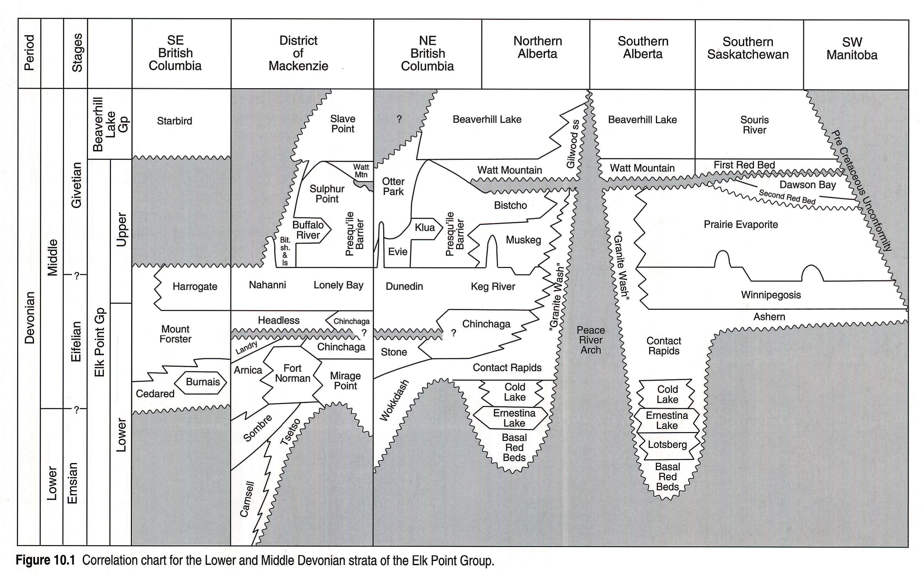
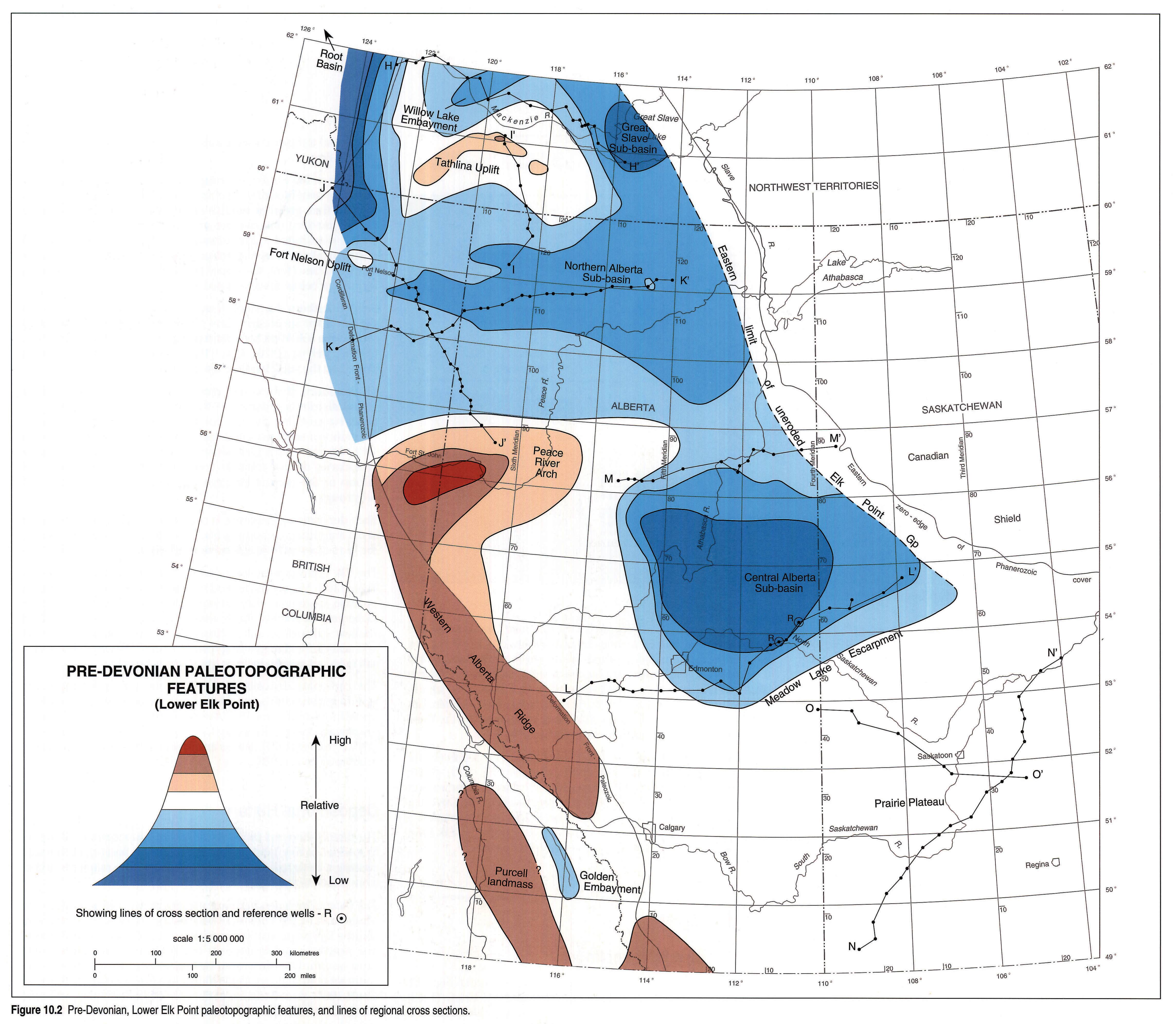
In the Interior Plains, the Lower to Middle Devonian clastics, redbeds, evaporites and carbonates of the Elk Point Group (Fig. 10.1) overlie Precambrian or lower Paleozoic rocks with an erosional unconformity that has up to 1400 m of relief. The sediments and evaporites accumulated in paleotopographic basins separated by highlands. Tathlina Highland, Western Alberta Ridge and Peace River Highland (Fig. 10.2) remained emergent during the Middle Devonian.
Lower and lower Middle Devonian strata are present in the southern Mackenzie Mountains (NWT) and extend eastward into the subsurface of the northern plains. They accumulated in Root Basin and Willow Lake Embayment (Fig. 10.2). Here the Lower Elk Point subgroup (Fig. 10.1) reaches a thickness of more than 1000 m. Equivalent beds in the southern plains attain a maximum thickness of 358 m.
The strata of the Upper Elk Point subgroup conformably overlie the lower subgroup and accumulated in the Willow Lake and Elk Point embayments. They attain a thickness of more than 340 m in the northern plains and 215 m in the southern plains.
The Elk Point strata are discontinuously exposed along the northeastern margin of the Western Canada Sedimentary Basin in southeastern Manitoba, western Saskatchewan, northeastern Alberta and the southeastern part of the District of Mackenzie. They are also exposed in the Cordilleran Orogen to the west.
Previous Work
There are many reports available that deal with the economically important Lower and Middle Devonian rocks of Western Canada. The Pine Point lead-zinc deposits in the District of Mackenzie, Northwest Territories were described by Campbell (1967), Skall (1977), Kyle (1981), Rhodes et al. (1984) and Krebs and Macqueen (1984); the lead-zinc deposits in northeastern British Columbia were discussed by Taylor et al. (1975).
The salt deposits in the subsurface of the Interior Plains were mapped by Hamilton (1971) and Meijer Drees (1986); the potash deposits in southern Saskatchewan by Holter (1969). Some of the oil pools in the Rainbow Lake field of northern Albera were described by Hriskevich (1968), Langton and Chin (1968) and Frydl (1989); the Zama Lake reservoir rocks were described by McCamus and Griffith (1967). Collins and Lake (1989) discussed the Sierra gas field of northeastern British Columbia. The reservoir rocks of the Pointed Mountain, Kotaneelee and Beaver River gas fields of northeastern British Columbia and the District of Mackenzie were described by Snowdon (1977) and Morrow et al. (1986). Those of the Tableland oil field in southeastern Saskatchewan were discussed by Martindale and MacDonald (1989). The reservoir rocks of the Mitsue and Nipisi oil fields in central Alberta were described by Kramers and Lerbekmo (1967), Shawa (1969) and Alcock and Benteau (1976).
Regional studies on the Elk Point strata include the compilations of Grayston et al. (1964), Belyea and Norris (1962), Law (1955, 1971), Douglas et al. (1970), Belyea (1971) and Meijer Drees (1990). The Elk Point strata along the northeastern outcrop edge in the District of Mackenzie, Alberta, Saskatchewan and Manitoba were described by Douglas and Norris (1960a), Norris (1963, 1965), Norris et al. (1982), and Vopni and Lerbekmo (1972). Those exposed in the Rocky Mountains of Alberta and northeastern British Columbia and the Mackenzie Mountains of the Yukon and Northwest Territories were described by Norford (1981), Taylor and Mackenzie (1970), Morrow (1978), Morrow and Cook (1987), and Douglas and Norris (1960b, 1961, 1963).
Geological Framework
The lower part of the Elk Point succession onlaps an irregular surface of considerable relief. In the interior plains of the District of Mackenzie the succession unconformably overlies Ordovician and Silurian carbonates; in northern Alberta it overlies Precambrian igneous and metamorphic rocks; in southern Alberta it overlies Cambrian clastics and carbonates. In southern Saskatchewan, the pre-Devonian surface consists again of Ordovician and Silurian carbonates. The absence of lower Paleozoic strata in the Northern Alberta sub-basin suggests that this region was deeply eroded before the onset of Devonian deposition.
The formations in the upper part of the Elk Point Group are widely distributed and outline an ancient embayment (the Elk Point Embayment) that extended southeastward from northeastern British Columbia and the District of Mackenzie into the Williston Basin of southern Saskatchewan, Manitoba and North Dakota. The smaller embayment in southwestern British Columbia (the Golden Embayment) is separated from the Elk Point Embayment by the Western Alberta Ridge in southwestern Alberta (Fig. 10.2).
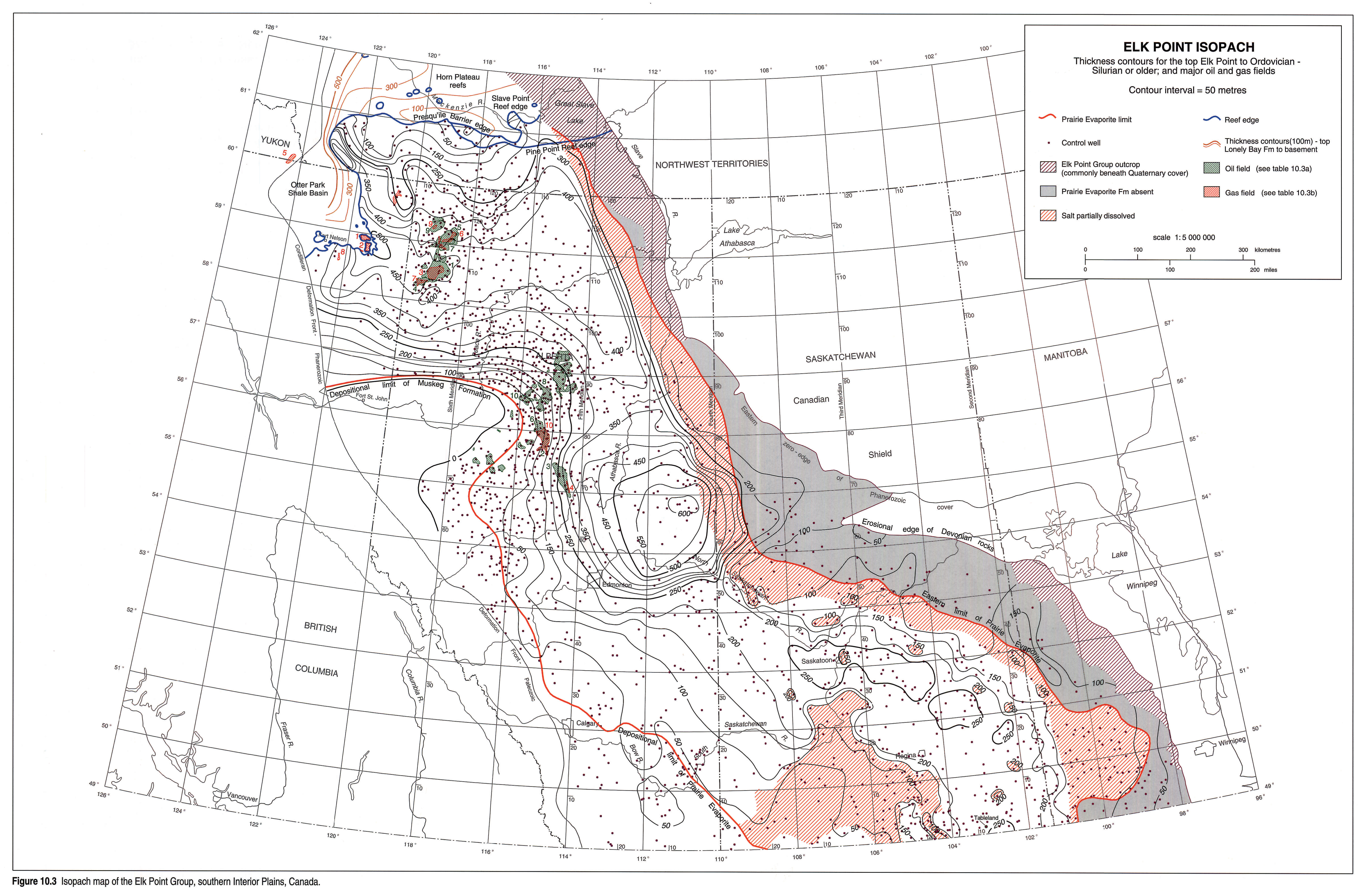
The upper boundary of the Elk Point Group is a relatively flat surface; consequently the Elk Point isopachs (Fig. 10.3) clearly indicate the outline of the paleotopographic basins and the amount of paleotopographic relief. In the area southwest of the Devonian outcrop belt that parallels the Canadian Shield, the orientation of the isopachs changes. Here, salt was leached from the Elk Point succession, resulting in a collapse of the upper surface.
Stratigraphy
Stratigraphic Nomenclature
The Elk Point Group includes formal and informal units (Fig. 10.1) that were introduced by Baillie (1953), Law (1955), Sherwin (1962), Belyea and Norris (1962), and Gray and Kassube (1963). Some of the formal definitions were subsequently modified to reflect new information.
The base of the Elk Point Group coincides with the pre-Devonian erosional unconformity. The top of the Elk Point is defined at the top of a thin, green or reddish brown shale unit (the Watt Mountain Formation) that overlies an unconformity. The shale unit is widely distributed in the subsurface of the southern plains. In the northern plains it is not present and the underlying formations change facies. Here, the upper boundary is selected at the unconformity or below the associated hiatus.
Several authors described local erosional unconformities within the Elk Point succession. Law (1955) and Meijer Drees (1988) described the sub-Watt Mountain unconformity; Douglas and Norris (1961a), Belyea (1970), Law (1971), and Meijer Drees (1990) reported on the sub-Headless unconformity.
The presence of these two erosional unconformities and the regional distribution pattern of the dominant lithologies within the basin suggest that the Elk Point Group includes three complete depositional sequences and the basal part of a fourth one (Moore, 1988; Morrow and Geldsetzer, 1988). However, the sequence boundaries do not coincide with either the top of the Elk Point Group or the contact between the Lower and Upper Elk Point subgroups.
Each depositional sequence is composed of marginal clastics, redbeds, anhydritic carbonates and fossiliferous carbonates. Some of the sequences include extensive evaporites.
The Elk Point nomenclature used in the subsurface is shown on Figure 10.1. Map units defined in outcrop sections are not included because, in general, they do not make suitable reference sections. Coherence of the evaporitic interbeds is lost on exposure. In the shallow subsurface, salt is dissolved by circulating groundwater and anhydrite changes to gypsum. Beds overlying the collapsed salt crop out as carbonate or gypsiferous breccia.
The carbonate deposits of the Elk Point Group locally contain age-diagnostic corals, brachiopods, conodonts and ostracods. The correlations on Figure 10.1 incorporate the results of the biostratigraphic studies published by Craig et al. (1967), Fuller and Pollock (1972), Pedder (1975), Norris and Uyeno (1983), Norris et al. (1982) and Braun et al. (1988).
Depositional History
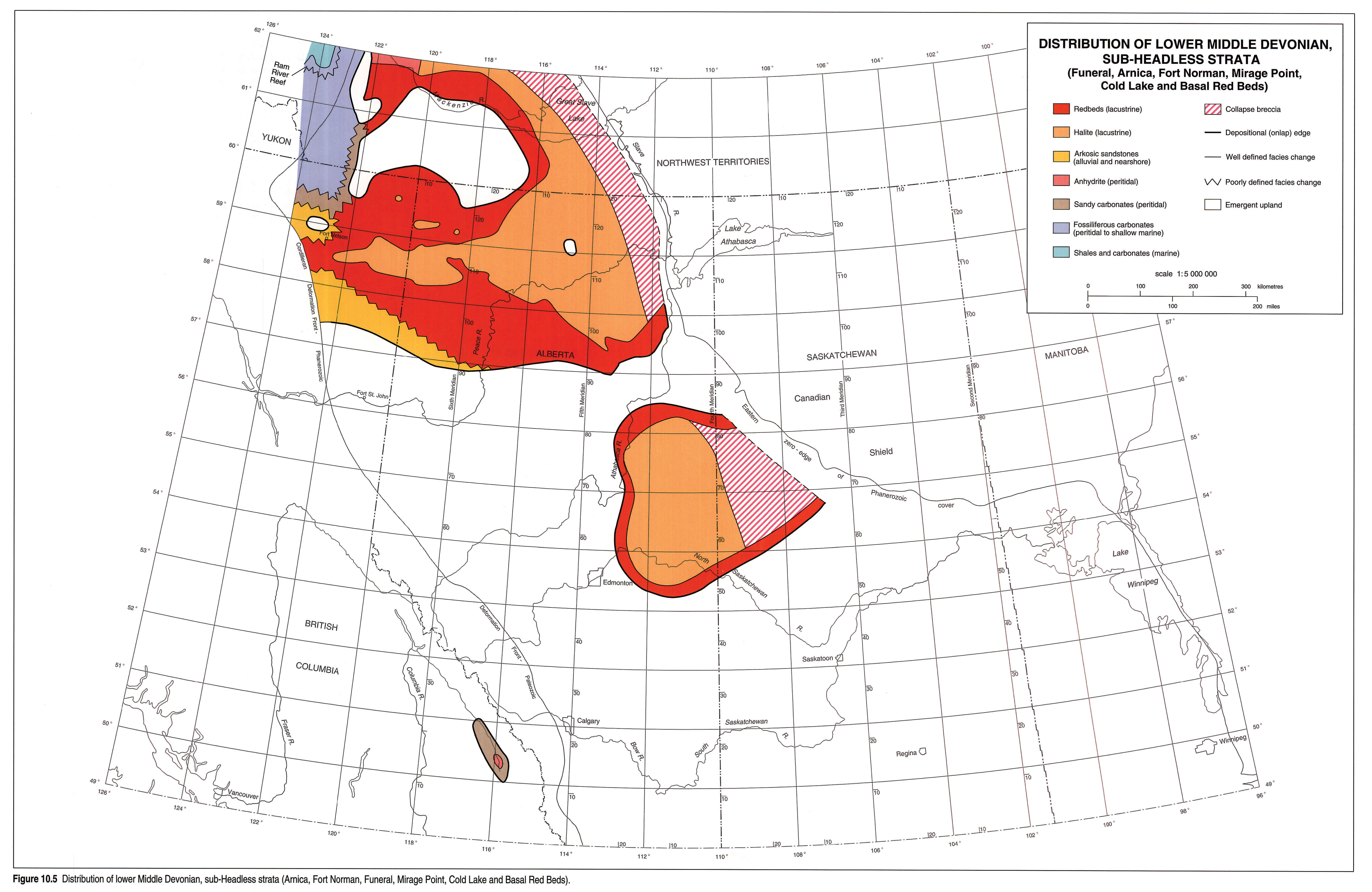
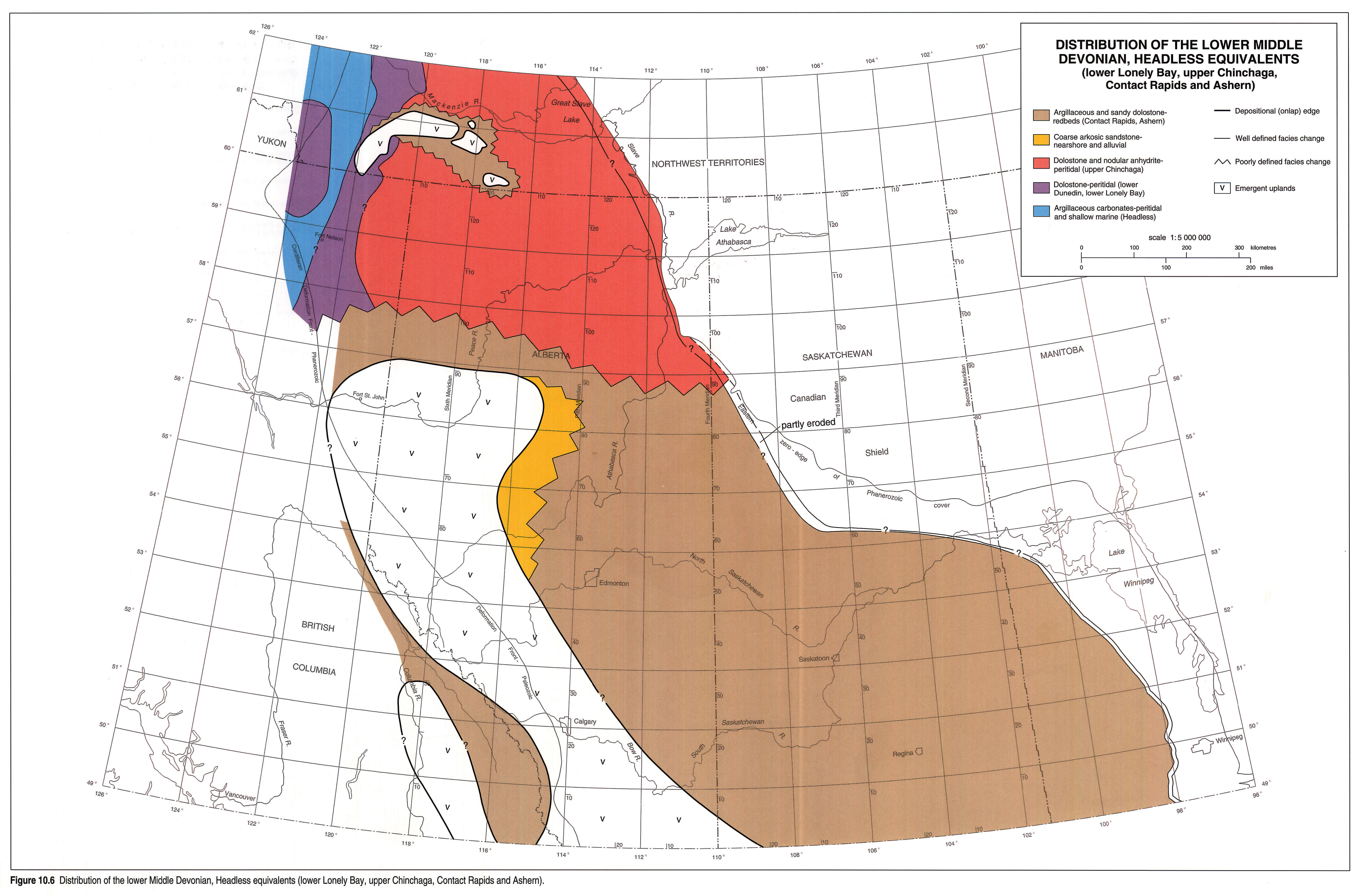
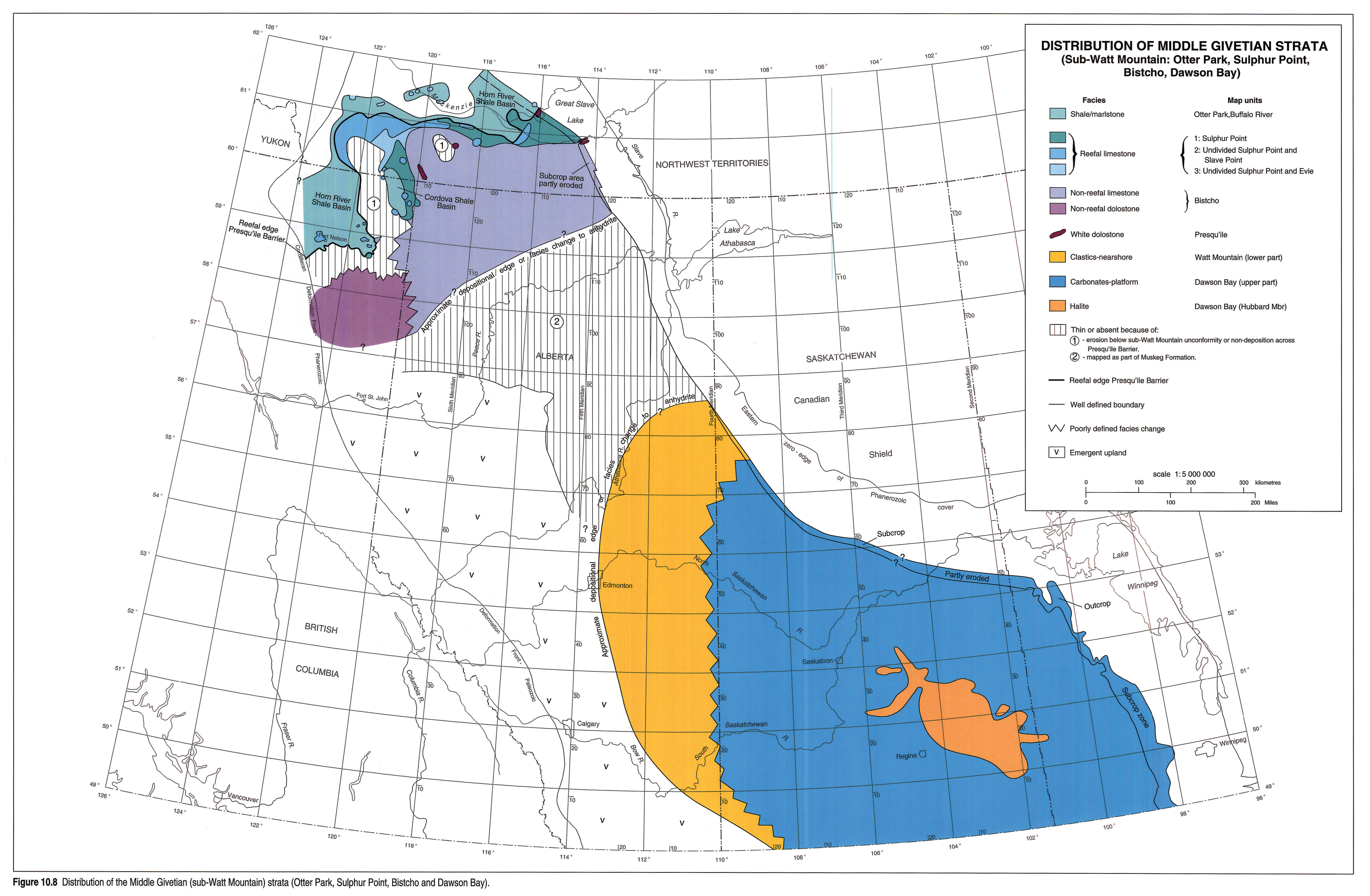
The distribution and facies of Elk Point Group strata are illustrated in a series of five maps (Figs. 10.4, 10.5, 10.6, 10.7, 10.8), each encompassing a designated stratigraphic interval.The maps are ordered from oldest to youngest.
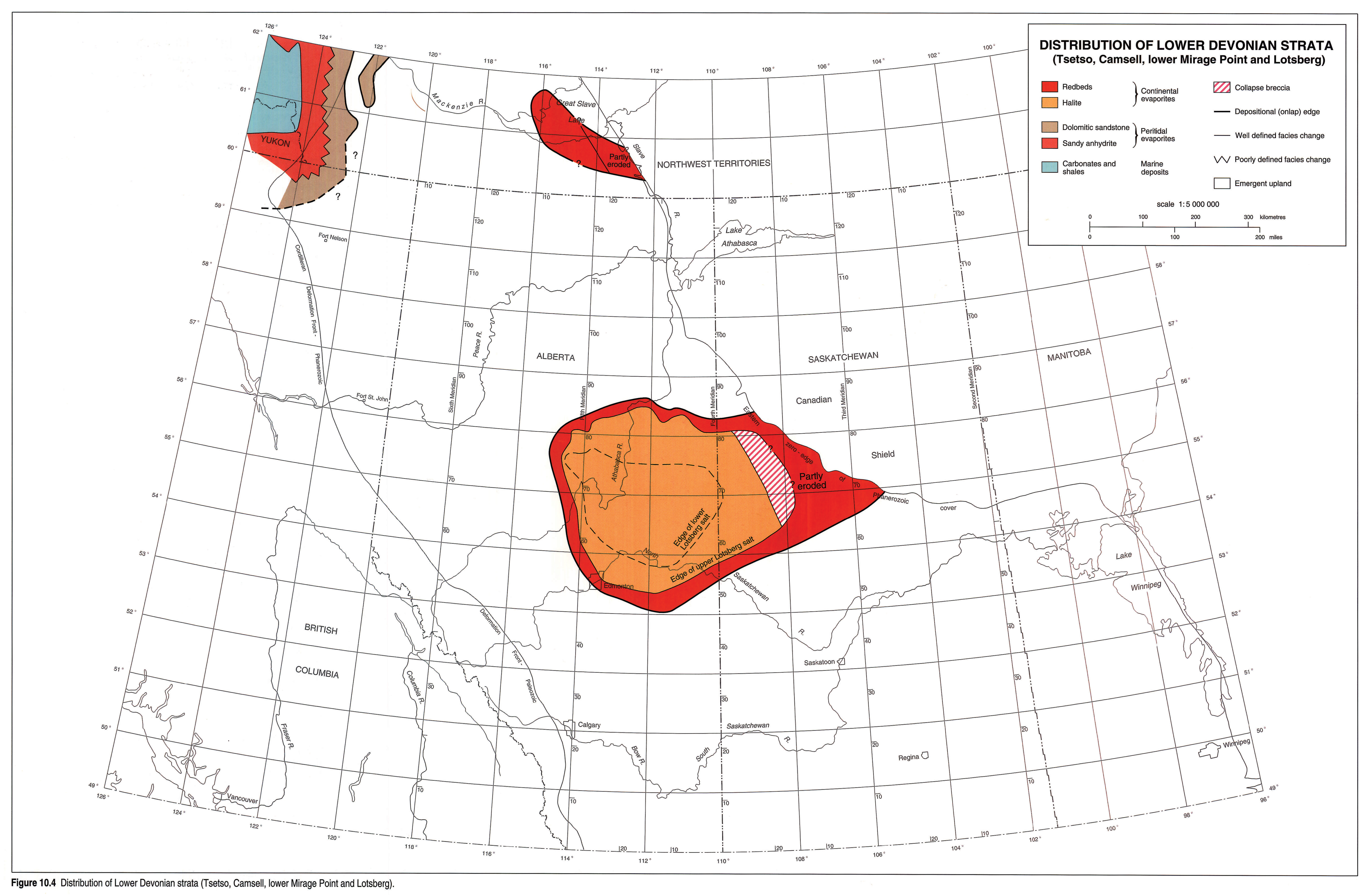
The oldest Devonian beds are present in the southern Mackenzie Mountains of the District of Mackenzie. Here, Lower and lower Middle Devonian shallow-marine carbonates, peritidal evaporites and nearshore sandy deposits of the Camsell and Tsetso formations accumulated in a semi-restricted to restricted marine environment in Root Basin and Willow Lake Embayment (Morrow and Cook, 1987). Root Basin lies at the edge of the Devonian continental margin, and the great thickness of the sediments in the basin indicates that the basin was subsiding.
The sandstones, redbeds and Lotsberg salt deposits that accumulated in the Great Slave, Northern Alberta and Central Alberta sub-basins southeast of Root Basin (Fig. 10.4) were deposited in a tectonically stable, continental environment (Meijer Drees, 1980; Wardlaw and Watson, 1966). These unfossiliferous rocks are assumed to be Lower Devonian (Fig. 10.1).
During the onset of early Middle Devonian time, the sea invaded these continental basins and the fossiliferous carbonates of the Ernestina Lake (or Fitzgerald) Formation were deposited. The Ernestina Lake Formation can be recognized as a marine unit in the peritidal and lagoonal, anhydritic carbonates of the Mirage Point and Fort Norman formations (Meijer Drees, 1990), suggesting that the invasion was from the north. It is dated as early Middle Devonian on the basis of ostracods and a coral (van Hees, 1956; Norris 1963; Rice, 1967). Redbeds, evaporites and peritidal sediments accumulated along the margins of the basins and in the channels that connected the southern basins with Root Basin (Fig. 10.5).
It is assumed that eventually the channels became choked with sediment, causing circulation in the central parts of the Willow Lake Embayment and the Northern and Central Alberta sub-basins to become restricted. Excessive evaporation led to the deposition of salt. The bromide composition of the Cold Lake salt in the District of Mackenzie suggests that the salt originated from sea water (Holser et al. 1972). The Cold Lake salt in the Central Alberta sub-basin has a continental aspect (Wardlaw and Watson, 1966).
After deposition of the Cold Lake salt, a second marine transgression took place and the Elk Point Embayment was filled with redbeds and peritidal evaporites. The onlap pattern of the strata directly above the Cold Lake Formation (Fig. 10.1) suggests that sea level kept rising. During this transgressive period a reefal barrier (the Ram River reef complex on Fig. 10.5) developed along the eastern margin of Root Basin.
A relative fall in sea level followed by a regression and minor erosion is inferred from the presence of the sub-Headless unconformity in the District of Mackenzie. This period of erosion concluded the first part of the depositional history of the Elk Point Embayment.
The sea invaded the embayment for a third time during the early Middle Devonian. Shaly and fossiliferous, nearshore and peritidal carbonates of the Headless Formation onlap the unconformity and grade southeastward into peritidal carbonates (lower Lonely Bay), evaporitic carbonates (upper Chinchaga) and nearshore clastics or redbeds (Contact Rapids and Ashern formations). These transgressive deposits are widely distributed and extend southeastward (Fig. 10.6) into Williston Basin. The upper, regressive part of this assemblage includes the fossiliferous, shallow-marine carbonates of the Winnipegosis, Keg River, upper Lonely Bay, Dunedin and Nahanni formations. The carbonates of the Harrogate and Mount Forster formations in the southern Rocky Mountains of British Columbia are also representative of this regressive phase (Fig. 10.1).
An increase in the rate of subsidence or a rise in sea level coupled with a reduction in the production of carbonate sediment initiated vertical reef growth. During this late Middle Devonian transgression, the reef mounds at the entrance of the Elk Point Embayment amalgamated with inter-reef deposits to form the Presqu'ile Barrier (Fig. 10.7).
The formation of the reefal barrier limited flow of sea water into the embayment to the southeast and conditions became restricted. During periods of low water level and excessive evaporation, anhydrite and salt (Muskeg and Prairie Evaporite formations) accumulated in the supratidal flats, coastal lagoons and ephemeral lakes behind the barrier by the process of "evaporative drawdown" (Maiklem, 1971). Klingspor (1969) and Corrigan (1975) documented several major cycles of flooding and desiccation in the southeastern part of the Elk Point Embayment. These events led to partial dissolution of previously deposited evaporites and the accumulation of potash salts.
Sea level fell after the accumulation of these evaporites and the entire embayment became emergent during the mid-Givetian (sub-Watt Mountain) regression. Parts of the Peace River and Tathlina highlands were eroded and the Presqu'ile Barrier was exposed. The nearshore and ancient alluvial granite-wash deposits in the highlands were eroded and dispersed by rivers into the former embayment, under moist climatic conditions. The southeastern part of the Elk Point Embayment remained emergent and here the salt deposits were partly leached and recrystallized into potash-rich minerals. The Second Red Bed probably is an eolian deposit. Reef growth along the seaward (northwest) edge of the Presqu'ile Barrier established itself at a lower level and prograded seaward to form the biostromal and associated deposits of the Sulphur Point Formation (Meijer Drees, 1988) that overlie older slope and basinal deposits of the Evie and Klua formations (Figs. 10.1, 10.8).
During the initial phase of the subsequent late Givetian to early Frasnian rise in sea level, the Sulphur Point reef edge stablized and sandy deposits around the Peace River Highland were reworked into the nearshore, deltaic and lagoonal sediment of the Gilwood Member (Watt Mountain Formation; Jansa and Fischbuch, 1974). Fossiliferous carbonates of the Dawson Bay Formation prograded into the southeastern part of the Elk Point Embayment. A return to evaporitic conditions led to a halt of sand transport from the highland and to the accumulation of salt (the Hubbard Member) in the southeastern part of the former embayment. Windblown deposits of green and reddish brown silt and siliceous clay are present in the First Red Bed and the upper part of the Watt Mountain Formation.
Morrow (1973) suggested that during the mid-Givetian (sub-Watt Mountain) regression, meteoric water entered the subsurface causing local dissolution and extensive dolomitization of the Presqu'ile Barrier limestones. This porous, paleo-aquifer system and the older, sub-Headless paleo-aquifer system were subsequently flushed and enlarged during post-Devonian periods of uplift and erosion. The leached parts of the carbonates were altered to a white, coarse-crystalline dolomite facies (the Manetoe and Presqu'ile diagenetic facies) that is host to the lead-zinc deposits at Pine Point (Rhodes et al., 1984) and is gas bearing at Beaver River, Pointed Mountain and Kotaneelee (Morrow et al., 1986).
Regional Cross Sections
The stratigraphic cross sections accompanying this chapter are selected to show the salient geological features of the Elk Point Group. In the following paragraphs, the group is described from the base upward and from north to south. For practical reasons it is not possible to show all the gelogical features in the sections. It was decided not to be rigid in the choice of datum. In some sections two or more datum surfaces are used if this is warranted.
The oldest Devonian formations in Western Canada are penetrated by the Pan Am Mattson Creek No. 1 well, (lat. 61°02'28"N, long. 123°48'30"W) located in the District of Mackenzie, just west of Nahanni Butte (Fig. 10.2). Here, Ordovician carbonates are overlain by an interbedded succession of gray silty and sandy dolostone, dolomitic sandstone and silty or sandy anhydrite that is 1304 m thick. The interval includes the equivalents of the Root River, Camsell and Tsetso formations (Morrow and Cook, 1987; p. 21). These formations onlap the lower flank of Tathlina Highland in the west and are not present in the subsurface of the Interior Plains.
Cross section H-H'
The cross section across the southern part of the Willow Lake Embayment (Fig. 10.9) represents an area higher up on the flank of Tathlina Highland. Here, evaporites of the Fort Norman and Mirage Point formations onlap the pre-Devonian unconformity. The correlations below the Headless Formation indicate that the carbonates of the Landry, Manetoe and Arnica formations change eastward into evaporites. These evaporites onlap a highland that separates the Willow Lake Embayment from the Great Slave sub-basin.
The sub-Headless unconformity has been traced southeastward on Figure 10.9 into the redbeds that overlie the Cold Lake Formation. The correlations directly above the unconformity show the lateral facies changes due to transgression and onlap. The argillaceous limestones of the Headless grade eastward into Lonely Bay dolostone and upper Chinchaga anhydrite.
By using the top of the Nahanni and Lonely Bay formations as the datum, the complex stratigraphic relations between the shaly inter-reef deposits and the reefal carbonates along the edge of the Presqu'ile Barrier, including the "bitumimous shale and limestone beds" and the Buffalo River and Sulphur Point formations, can be displayed.
Cross section I-I'
The Elk Point strata onlap and overlap Tathlina Uplift in the southern part of the District of Mackenzie (Fig. 10.10). The map units that are part of the Presqu'ile Barrier directly overlie Precambrian rocks in the northern part of the cross section. Correlations indicate that the sub-Watt Mountain unconformity divides the barrier into lower and upper parts. The lower part of the Presqu'ile Barrier includes the Sulphur Point Formation and the Presqu'ile and Pine Point map units. The upper part of the barrier is represented by the reefal facies of the Slave Point Formation and belongs to the Beaverhill Lake Group.
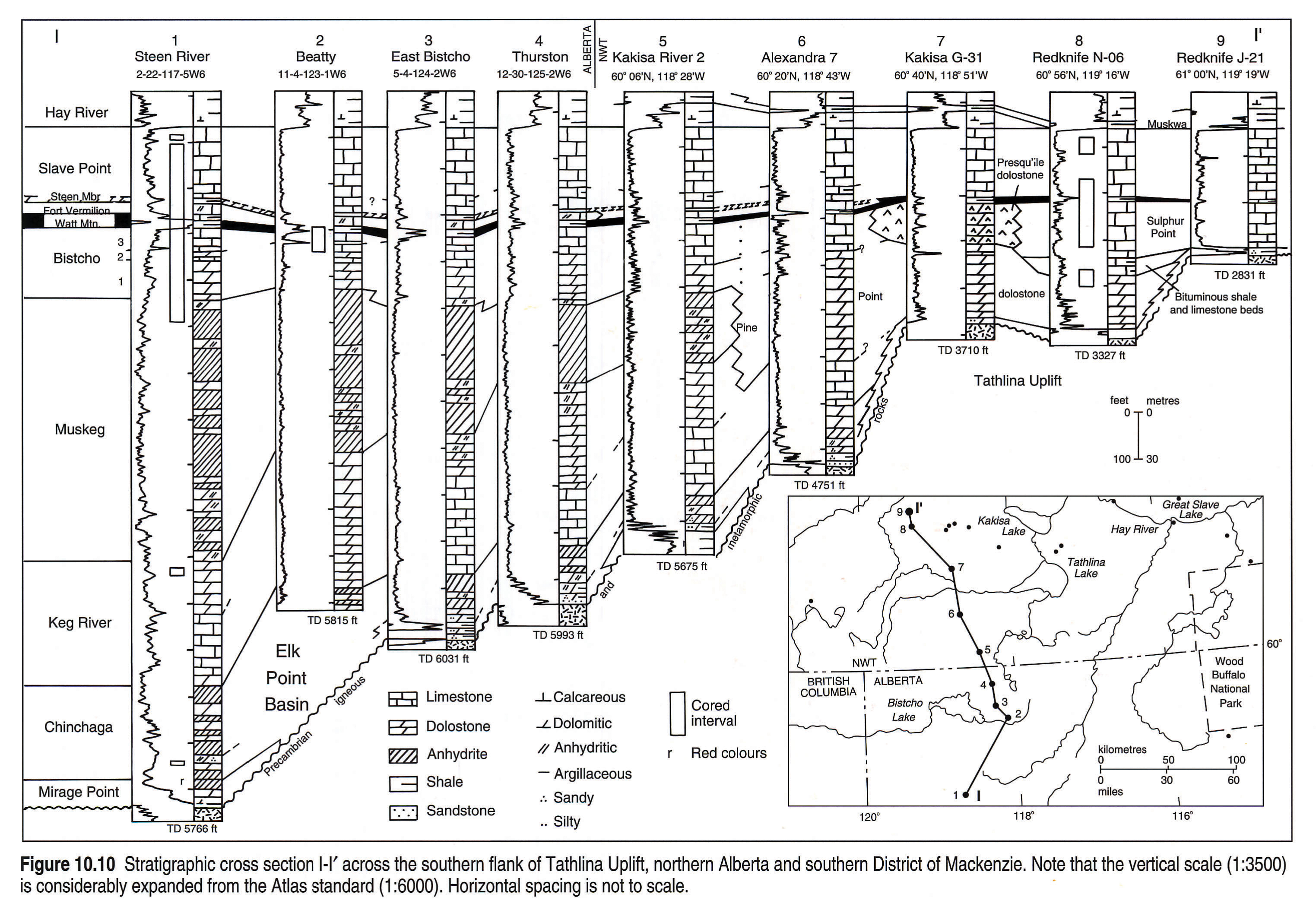
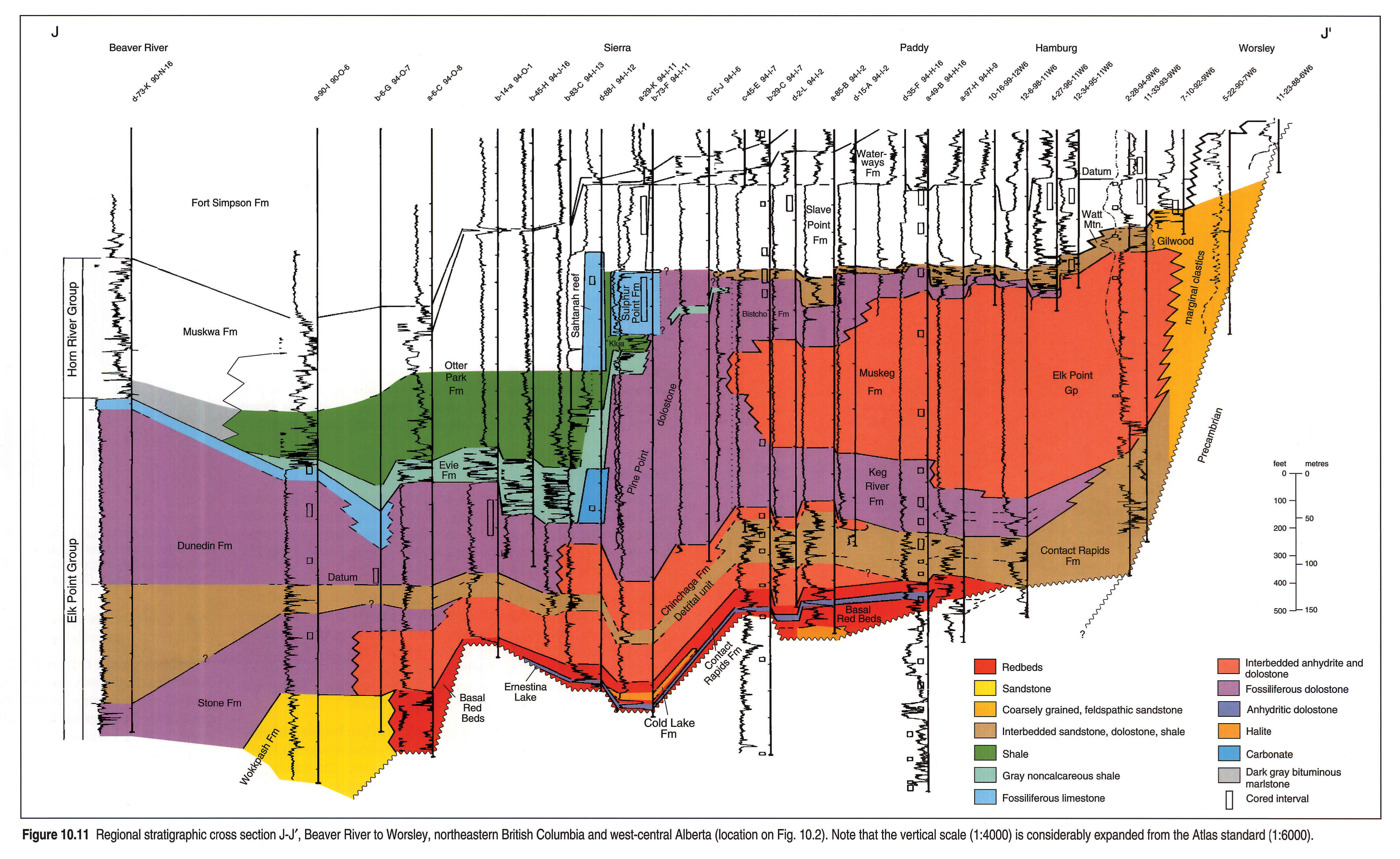
Cross section J-J'
The stratigraphic relations within the Elk Point Group in northeastern British Columbia and northwestern Alberta are shown in the cross section Figure 10.11. The boundary between the Dunedin and Stone formations (Griffin, 1967) in the northwestern part of the figure probably coincides with the sub-Headless unconformity, but it is not known if this unconformity extends southeastward into the Chinchaga Formation. The argillaceous and silty carbonates overlying the Stone Formation grade southeastward into the detrital unit. Below this unit the Elk Point is relatively thin and is represented by nearshore clastics, redbeds, carbonates and evaporites of the Wokkpash, Basal Red Beds, Ernestina Lake, Cold Lake and lower Chinchaga. These units accumulated in local depressions of the Northern Alberta sub-basin. The Ernestina Lake carbonates extend farther onto the highlands than the salt deposits of the Cold Lake, suggesting that this sub-basin probably diminished in size as a result of evaporation. The Lower Elk Point map units in Alberta onlap Peace River Highland and change southeastward into nearshore dolomitic and continental granite-wash sandstones of the Contact Rapids Formation and the marginal clastics unit. The Elk Point strata directly above the detrital unit include fossiliferous carbonates that change southeastward into anhydritic and sandy carbonates and arkosic sandstones.
The upper part of the Elk Point Group (Fig. 10.11) consists of a progradational wedge of carbonate deposits that is truncated by the sub-Watt Mountain unconformity. The prominent facies change from carbonates to shales in the central area of the figure represents the seaward part of the wedge. It is composed of reefal deposits similar to those of the Presqu'ile Barrier in the Great Slave Lake region, although the stratigraphic nomenclature is different.
The fossiliferous carbonates of the Dunedin Formation (Fig. 10.11) are overlain by bituminous shale and limestone beds (the Evie Formation of the Horn River Group - Gray and Kassube, 1963) or locally grade upward into low or high reef mounds similar to the Horn Plateau reefs (Fig. 10.8). Examples of such reef complexes are the Yoyo and Sierra gas fields of northeastern British Columbia. Other carbonate reef complexes occur above the Evie and Klua formations, either as separate mounds (Sahtanah reef) or as reef tongues that extend westward from the Presqu'ile Barrier into the Otter Park shale basin. It is not known whether these reefal deposits belong to the Elk Point Group or the Beaverhill Lake Group. The stratigraphic position of the Klua shale unit resembles that of the Buffalo River shale in the District of Mackenzie. The position of the Otter Park resembles that of the upper part of the Spence River Formation in the central part of Figure 10.9, suggesting that it may include early Frasnian strata.
The reefal deposits of the Presqu'ile Barrier change gradually southeastward into carbonates that include anhydrite interbeds. The lateral facies change between the fossiliferous carbonates of Pine Point dolostone unit, the Bistcho and the Keg River formations, and the evaporitic carbonates of the Muskeg Formation is difficult to map. Correlations in the southeastern portion of Figure 10.11 indicate that the carbonates of the Keg River Formation change into nearshore and continental sandstones, while the carbonates of the Bistcho Formation grade into anhydrite. The Watt Mountain Formation is a discontinuous map unit in the region southeast of the Presqu'ile Barrier and varies greatly in thickness. This is also seen in northern Alberta and the District of Mackenzie. The two components that give the characteristic gamma-ray signature of the Watt Mountain Formation apparently act independently of one another. One component reflects the presence or absence of shale-filled cavities in the carbonates below the sub-Watt Mountain unconformity. The other component signals the presence or absence of detrital sediment, overlying the unconformity, that was derived from the Peace River landmass. Thus the thick Watt Mountain sections may represent either sediment-filled erosional channels or breccia-filled depressions on a dissolution surface. Thin Watt Mountain sections include only the argillaceous and sandy "brackish water" deposits of the overlying, basal transgressive sediments that wedge out to zero toward the northwest.
The sub-Watt Mountain unconformity extends northwestward into the Presqui'le Barrier of the Sierra region (Fig. 10.11), but is elusive beyond the feather-edge of the overlying clastics because it onlaps a paleotopographic high area (Fig. 10.8). In the District of Mackenzie, the unconformity changes into a paraconformity that separates the reefal carbonates of the Sulphur Point from those of the Slave Point formations (Meijer Drees, 1988).
Red Earth cross section
A more detailed onlap pattern of the Elk Point strata against the Peace River Highland is shown in Figure 10.12. Here the facies changes between the redbeds and marginal clastics of the Contact Rapids Formation and carbonates and nearshore clastics of the Keg River Formation (also known as the "Granite Wash") indicate transgressive onlap. The relations between the Keg River Formation and the overlying evaporites suggest the presence of a platform edge in the upper part of the Keg River.
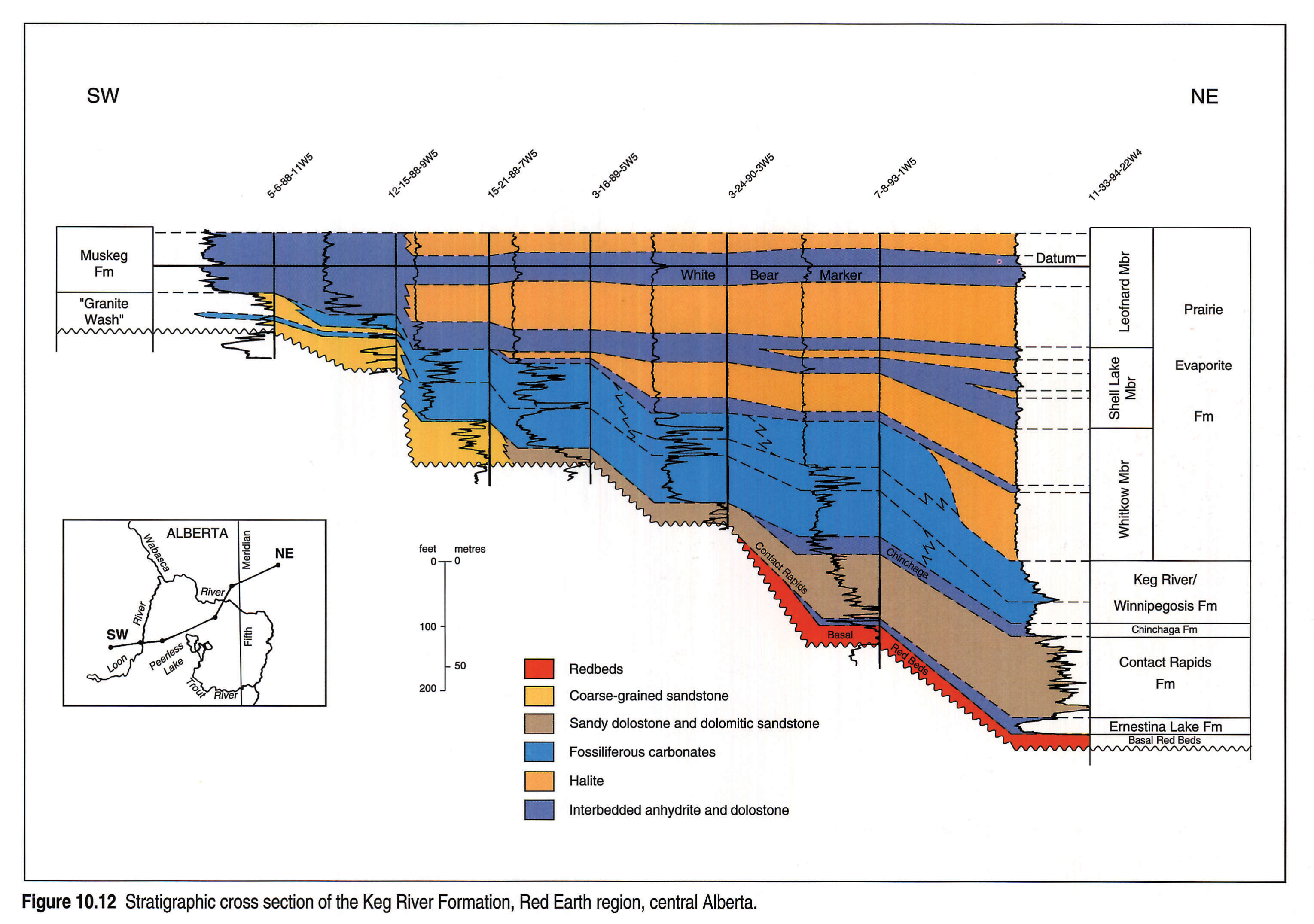
Worsley cross section
Both the Elk Point and Beaverhill Lake strata exhibit changes due to onlap along the northern flank of the Peace River Highland (Fig. 10.13). The anhydritic deposits of the Muskeg Formation change laterally into reddish brown mottled sandstones and shales. The sandy interbeds of the Watt Mountain Formation (the Gilwood Member) are extensions of a much thicker succession of nearshore and continental sandy deposits that onlaps and surrounds the landmass. By selecting the top of the Beaverhill Lake Group as a datum it is demonstrated that the Gilwood sandstone is diachronous. The marine part of the wedge belongs to the Elk Point Group, and the continental part to the Beaverhill Lake Group.
Cross section K-K'
The cross section on Figure 10.14 in northeastern British Columbia and northern Alberta represents a longitudinal slice across the northern Alberta sub-basin. On this figure, the contrast between the onlapping lower and the prograding upper parts of the Elk Point Group is not evident.
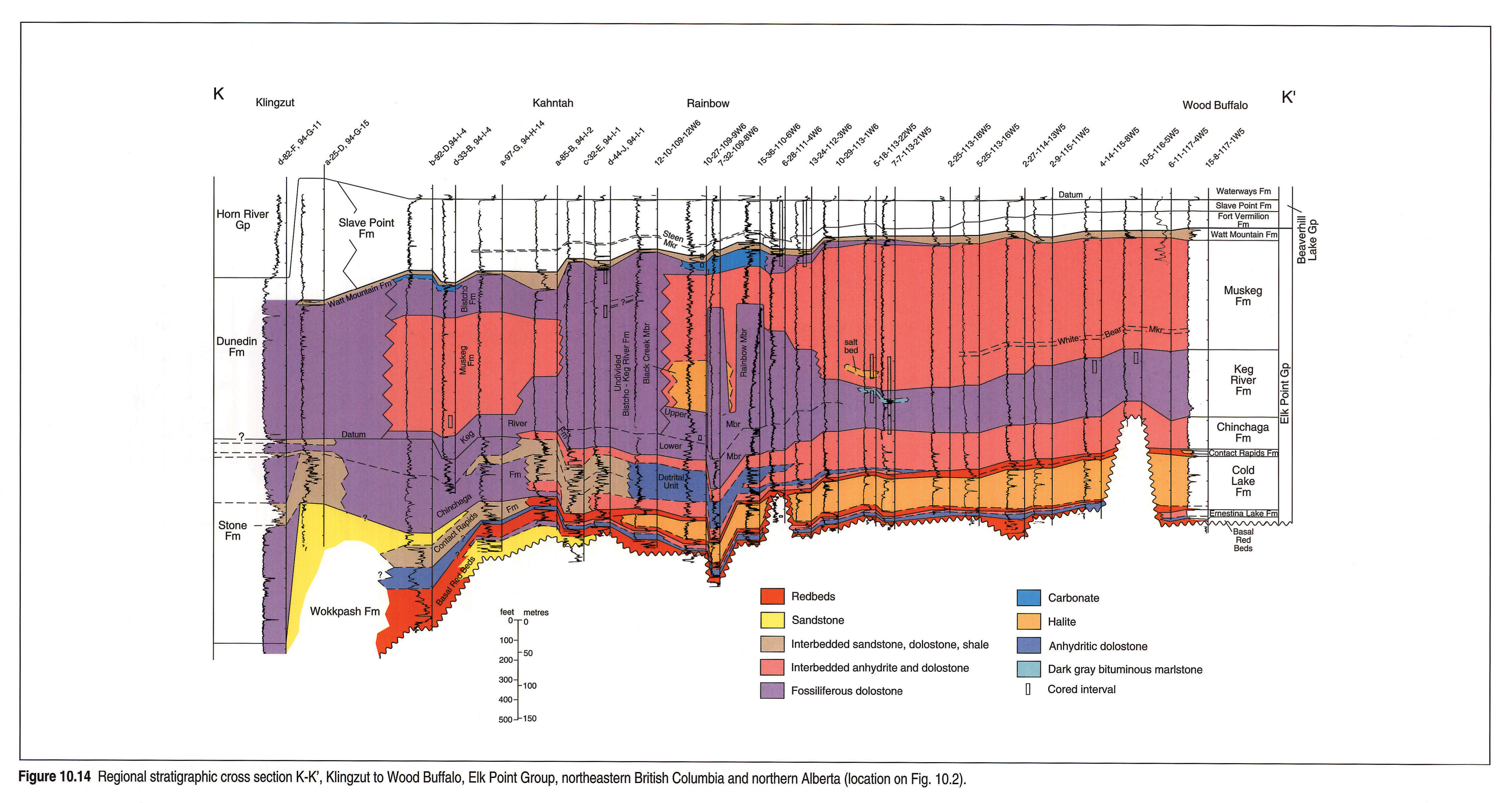
Thick, quartzose sandstone deposits (the Wokkpash Formation?) underlie and grade northeastward into an interbedded succession of sandstones, redbeds, carbonates and evaporites that includes the Basal Red Beds unit, and the Ernestina Lake and Cold Lake formations. The Cold Lake salt deposits increase in thickness toward the northeast at the expense of the overlying anhydritic redbeds, reaching a maximum of 76 m (Fig. 10.14).
The light gray, sandy dolostones and pale reddish brown, dolomitic siltstones of the Stone Formation grade northeastward into the dolomitic sandstones of the Contact Rapids, and the sandy and anhydritic dolostones of the Chinchaga Formation. There is no clear evidence of the sub-Headless unconformity.
The upper part of the Elk Point Group includes the carbonates of the Keg River and Bistcho formations and the anhydritic beds of the Muskeg Formation. In the Rainbow Lake area, the Muskeg Formation includes a salt deposit (the Black Creek Member) that is locally interrupted by carbonate mounds (the Rainbow Member of the Keg River Formation). The mounds resemble those in the Deep Bay (Fig. 10.9) and Sierra (Fig. 10.11) areas. They contain oil and gas in the Rainbow and Zama Lake regions. It is possible that the sections in the "Undivided Bistcho - Keg River" unit on Figure 10.14 also represent carbonate mounds.
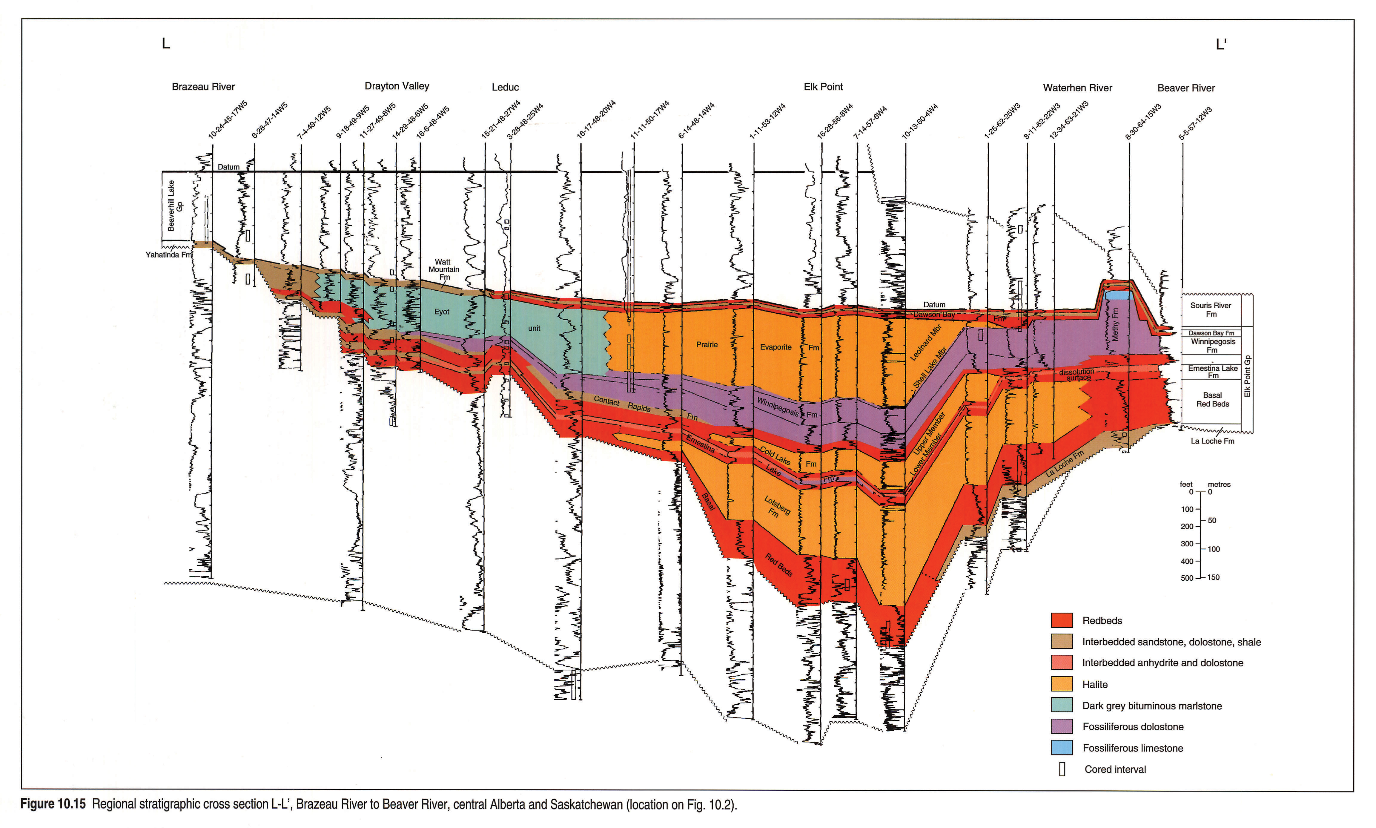
Cross section L-L'
The cross section across the central Alberta sub-basin (Fig. 10.15) shows the Elk Point strata onlapping the Western Alberta Ridge, a highland located in southwestern Alberta and composed of Cambrian rocks. The decrease in thickness to the northeast is due to the dissolution of salt deposits in the subsurface. Because the datum (top of Beaverhill Lake) does not compensate for the dissolved salt deposits and the presence of Winnipegosis reef mounds, the arrangement gives a false impression of tectonic uplift in the northeast. In reality, the dissolution of the salt deposits has resulted in collapse of the overlying strata (Meijer Drees, 1985; 1986, Fig. 33).
The lower part of the Elk Point Group in Figure 10.15 includes the Basal Red Beds unit, and the Lotsberg, Ernestina Lake, Cold Lake and Contact Rapids formations. The salt deposits in the central part of the basin grade into redbeds along the basin margin in the west. In the northeastern part of Figure 10.15, the lower part of the Lotsberg Formation changes laterally into redbeds; the upper part may have been dissolved. The overlying salt beds of the Cold Lake Formation have been dissolved entirely.
The upper part of the Elk Point Group in Figure 10.15 includes the Winnipegosis, Methy, Prairie Evaporite, Watt Mountain and Dawson Bay formations. The fossiliferous carbonates of the Winnipegosis Formation decrease in thickness toward the southwest and grade into silty and sandy dolostone of the underlying Contact Rapids Formation. The Winnipegosis Formation is correlative with the Methy Formation of Greiner (1956) and Norris (1963) in the northeastern part of Figure 10.15. Here, it locally includes an upper, reefal facies similar to the Rainbow Member of the Keg River Formation.
The lower, platformal part of the Winnipegosis Formation is overlain by the Prairie Evaporite Formation, which includes a thin, lower, dolomitic and anhydritic shale member (the Shell Lake Member) and a thick upper member of halite (the Leofnard Member - Meijer Drees, 1986). The Shell Lake Member and the salt deposits of the Leofnard Member appear to have accumulated after the growth of the reef mounds. Both members grade southwestward into a dark coloured, interbedded succession of nearshore argillaceous dolostone and dolomitic shale for which the informal name Eyot unit is proposed.
By using the top of the Beaverhill Lake Group as datum it is shown that the Watt Mountain Formation onlaps a pre-Devonian landmass in the southwest (the Western Alberta Ridge) and suggests a diachronous unit. The Watt Mountain Formation becomes thicker toward the northeast, where it includes the feather edges of the Dawson Bay Formation and the basal shale member (or "First Red Bed" unit) of the Souris River Formation.
Cross section M-M'
The cross section northeast of Peace River Highland in the Utikuma Lake and Fort McMurray regions (Fig. 10.16) shows a highland in the east (the Canadian Shield). The lower Elk Point formations onlap the shield and grade into sandstones of the La Loche Formation and the Basal Red Beds unit. The correlations above the Contact Rapids and McLean River formations indicate the presence of a carbonate platform (including the Keg River and Winnipegosis formations) that onlaps the highland and grades into clastics. The upper part of this platform includes a shelf edge between the Algar River and Telegraph wells that is similar to the one shown in Figure 10.12.. East of this edge, the lower part of the carbonate platform is locally overlain by reefal mounds of the Methy Formation. The progradation of carbonates was apparently halted before the basin was filled in.
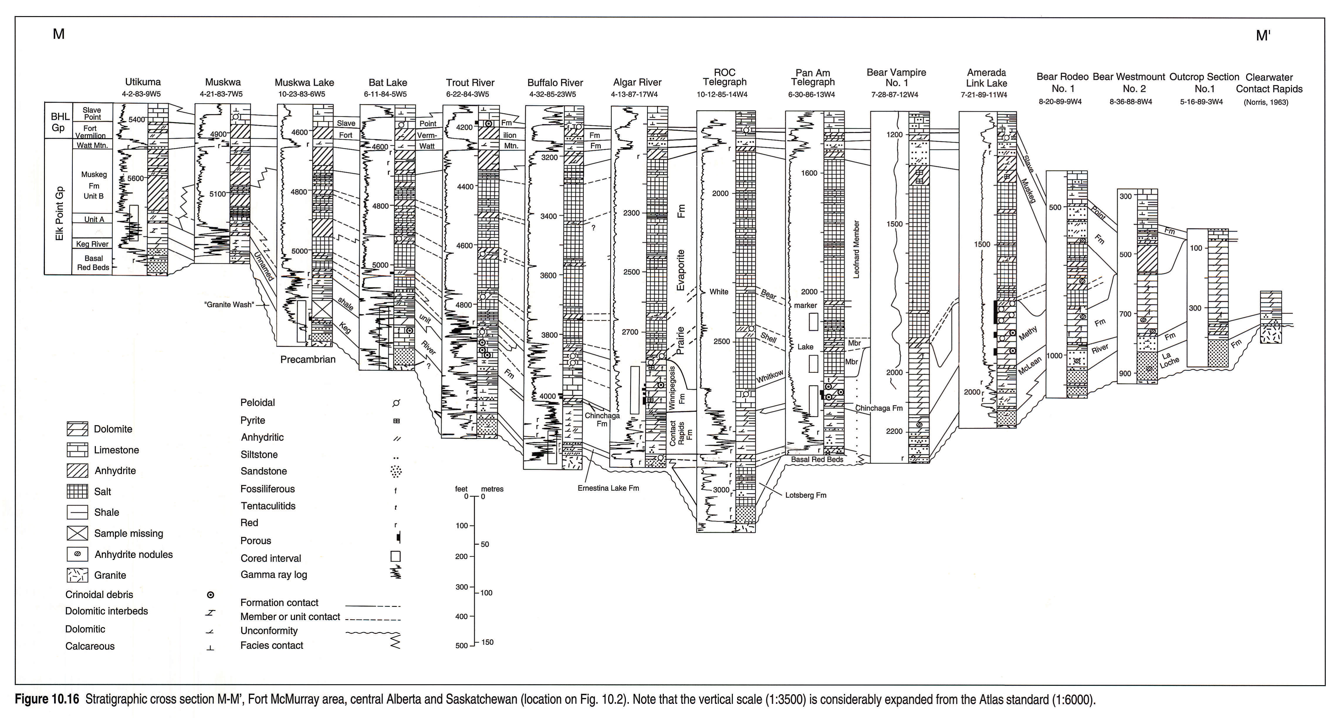
The evaporites of the Prairie Evaporite Formation in the centre of the cross section grade eastward into the Keg River Formation and an unnamed shale unit similar to the basal shale beds of the Eyot unit on Figure 10.15. The salt deposits of the Whitkow Member abutt the upper part of the underlying carbonate platform. The platform and Whitkow Member are overlain by the Shell Lake Member, which forms a marker bed that can be traced westward into the anhydritic shales of Unit A. The salt deposits of the Leofnard Member decrease in thickness toward the west and change laterally into anhydritic deposits of the Muskeg Formation.
Although the Dawson Bay Formation is not present on the cross section, information from boreholes to the south indicates that the anhydritic dolostone unit of the Dawson Bay Formation is equivalent to the anhydritic beds just below the Watt Mountain Formation in the Telegraph 6-30-86-13W4 well (Meijer Drees, 1986, Fig. 53). Evidence from a core in 14-29-52-2W4 suggests that the "First Red Bed" unit (Souris River Formation) overlies an erosional surface, whereas the "Second Red Bed" (Dawson Bay Formation) overlies a dissolution surface. The significance of these observations is schematically shown on Figure 10.1.
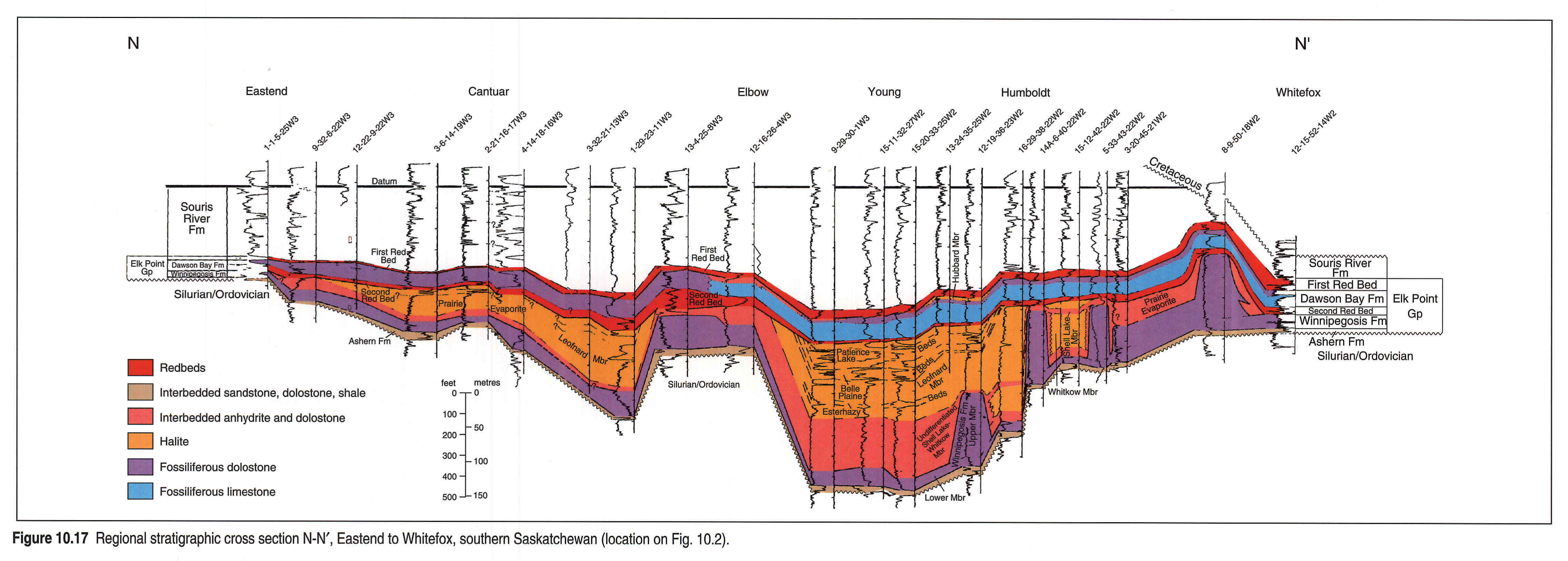
Cross section N-N'
The Elk Point Group in the southeastern part of the embayment in southern Saskatchewan (Fig. 10.17) is represented by the Ashern, Winnipegosis, Prairie Evaporite and Dawson Bay formations and the basal shale unit (the First Red Bed unit) of the Souris River Formation (Grayston et. al., 1964; Meijer Drees, 1986). Baillie (1953), Lane (1959), Norris et al., (1982) and Dunn (1982) considered the Dawson Bay and Souris River formations to be part of the Manitoba Group because of the pronounced non-conformity between the Prairie Evaporite and Dawson Bay formations as a result of leaching of Prairie Evaporite salt.
In Figure 10.17, the salt beds of the Prairie Evaporite Formation are locally absent because of post-Devonian dissolution and the local presence of Winnipegosis reefal mounds. These mounds are porous and contain oil in the Tableland oil field (Fig. 10.3). The correlations in Figure 10.17 also indicate that the Elk Point strata onlap a pre-Devonian highland in the southwest. The sandy and shaly dolostones of the Ashern Formation are widely distributed and onlap the highland. In this area both the Winnipegosis and Prairie Evaporite formations decrease in thickness to the southwest and change facies to redbeds that are difficult to distinguish from the clastics of the Ashern Formation.
The Winnipegosis Formation extends northeastward into the Devonian outcrop area of central Saskatchewan (Fig. 10.1). The formation varies greatly in thickness. In the central part of Figure 10.17 it includes a thin Lower member (Jones, 1965) overlain by a mound-forming Upper member. In places where the Lower member of the Winnipegosis Formation is overlain by salt of the Whitkow Member, there is a thin, intervening unit composed of laminated, locally anhydritic carbonates (the Ratner Member) that represents an inter-reef deposit (Shearman and Fuller, 1969; Wardlaw and Reinson, 1971; Reinson and Wardlaw, 1972). Along the southwestern margin of the basin, the upper part of the Winnipegosis Formation forms a carbonate platform up to 30 m thick that may include a shelf edge similar to the one shown in Figure 10.12..
The Prairie Evaporite Formation (Fig. 10.17) includes three members. The lower or Whitkow Member is composed mainly of halite, but locally also may consist of interbedded anhydrite and halite. The middle or Shell Lake Member is relatively thin and composed of anhydrite. It is difficult to define the Shell Lake Member in places where the Whitkow Member is mainly composed of anhydrite, and here the term "Undifferentiated Shell Lake -Whitkow" member is used (Reinson and Wardlaw, 1972). The upper or Leofnard Member forms the bulk of the Prairie Evaporite Formation and includes several deposits rich in potash, including the Esterhazy, Belle Plaine and Patience Lake beds.
The Dawson Bay Formation overlies the Prairie Evaporite Formation and includes a lower redbed member or "Second Red Bed" and an upper unit composed of carbonates including the Burr and Neely members (Dunn, 1982). It is locally overlain by a unit of salt (the Hubbard Evaporite of Lane, 1959). The Dawson Bay Formation is widely distributed (Fig. 10.17) and overlies the Winnipegosis Formation in places where the Prairie Evaporite salt has been dissolved. In these places the shaly and anhydritic residue from the Prairie Evaporite Formation is part of the "Second Red Bed" unit.
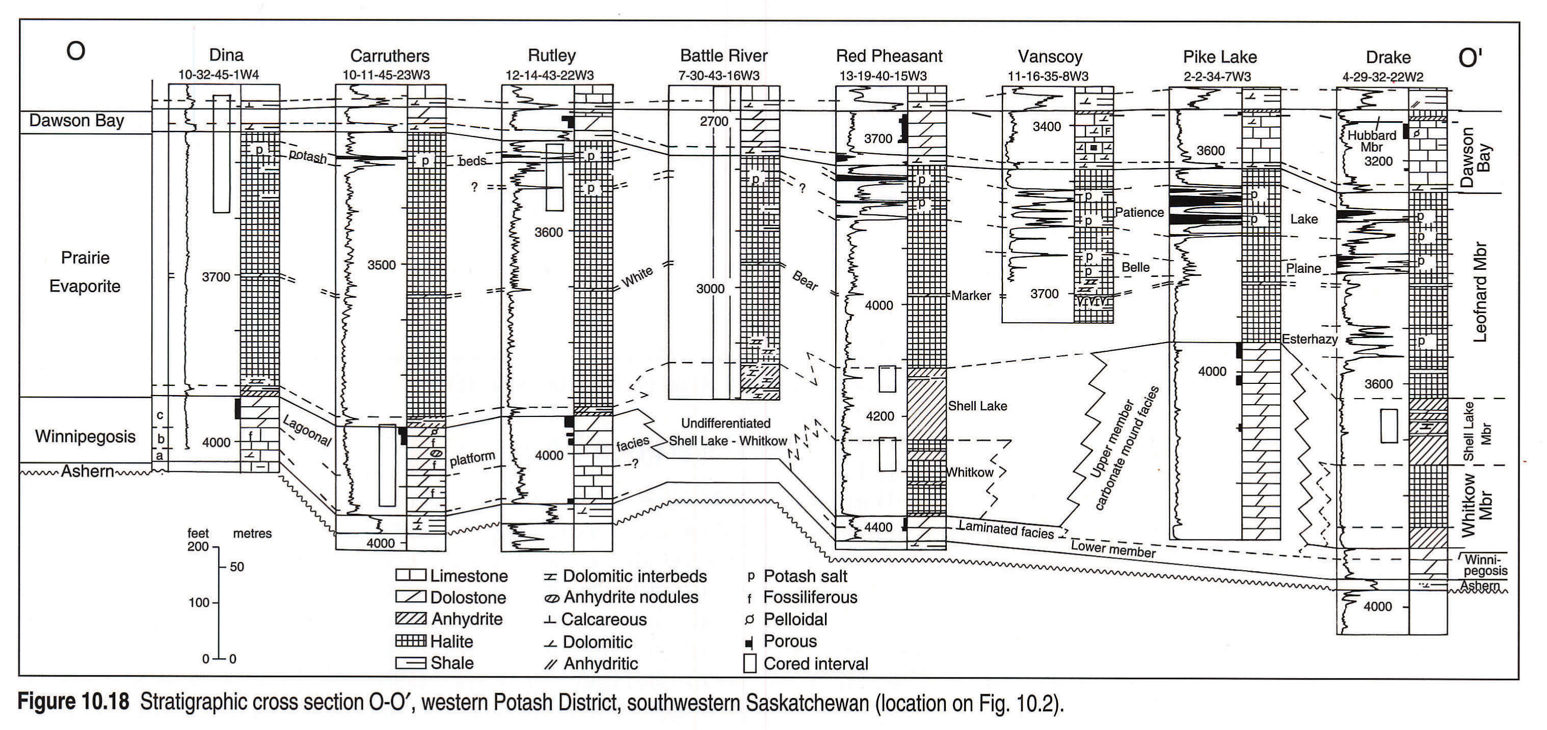
Cross section O-O'
In the central part of the Elk Point Embayment (Fig. 10.18) the potash-rich deposits form distinct, mappable units in the Leofnard Member of the Prairie Evaporite Formation. The Esterhazy Beds occur below the White Bear marker bed, whereas the Belle Plain and Patience Lake beds lie above the marker bed. The potash-rich units are interbedded deposits of impure halite, sylvite and carnallite (Holter, 1969).
The carbonates and evaporites in the upper part of the Dawson Bay Formation (Fig. 10.18) increase in thickness toward the southeast, replacing the underlying Leofnard Member. This suggests that the Prairie Evaporite Formation was affected by surficial dissolution before the Dawson Bay carbonates were deposited.
Reference Logs
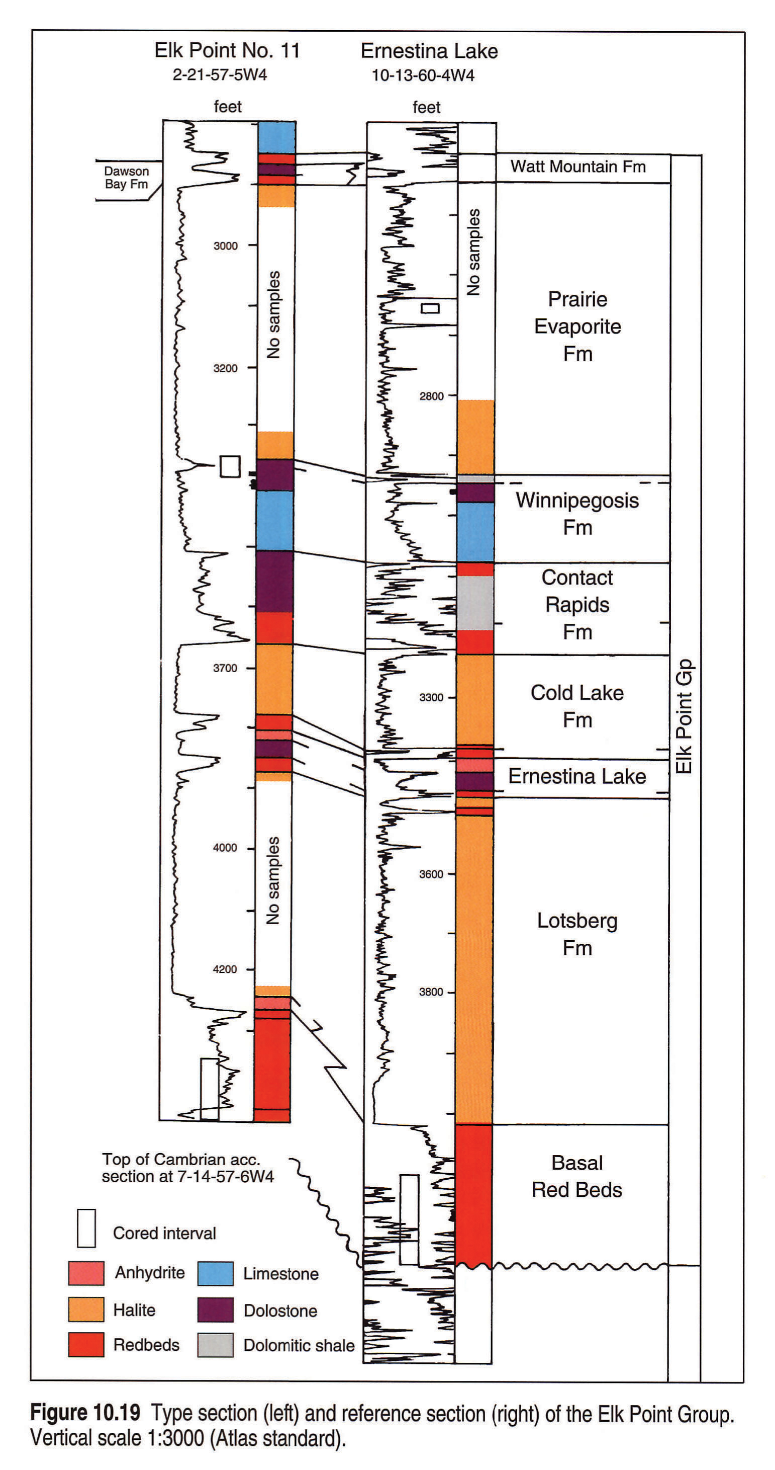
McGehee (1949) introduced the Elk Point Formation in central Alberta, and the Geological Staff of Imperial Oil Ltd. (1950) defined the top above the First Red Bed unit. The formation was given group status by Belyea (1952), and Baillie (1953) extended the Elk Point Group into southern Saskatchewan. Crickmay (1954) selected the type section for the Elk Point Group in central Alberta, shown in Figure 10.19. Law (1955, 1971) recognized the group in northern Alberta and the District of Mackenzie. Reference wells used by these authors are incorporated in the cross sections.
Crickmay's type section of the Elk Point Group in the Anglo Canadian Elk Point No. 11, 2-21-57-5W4 well is compared with the section in the Canadian Seaboard Ernestina Lake 10-13-60-4W4 well in which Sherwin (1962) defined the Basal Red Beds unit and the Lotsberg, Ernestina Lake, Cold Lake and Contact Rapids formations (Fig. 10.19). Information presently available suggests that the Elk Point succession in the Anglo Canadian Elk Point No. 11 well is incomplete because the well does not penetrate the Cambrian. It should also be noted that the shaly marker above the Winnipegosis Formation, composed of laminated, halite-impregnated, shaly and bituminous dolostone rich in charophyte oogonia, correlates with the Shell Lake Member (Figs. 10.15, 10.18). This locally anhydritized deposit was included by Reinson and Wardlaw (1971) in the Prairie Evaporite Formation.
The California Standard Steen River 2-22-117-5W6 well in northern Alberta (Fig. 10.10, section 1) was chosen to represent the type sections of the Chinchaga, Keg River, Muskeg, Watt Mountain and Slave Point formations. It is important to note that since Law (1955) introduced these map units, several authors have proposed changes in the stratigraphic nomenclature that affect the status and boundaries of the original Muskeg, Watt Mountain and Slave Point formations. Figure 10.10 shows the most recently proposed (Meijer Drees, 1988) subdivision into the Slave Point, Fort Vermilion, Watt Mountain, Sulphur Point and Muskeg formations.
Structure
The regional, long distance correlations of shaly and anhydritic marker beds on borehole logs in the Muskeg and Prairie Evaporite formations by Klingspor (1969) suggest that the markers were deposited as flat layers. The tops of the Prairie Evaporite, Watt Mountain and Dawson Bay formations in the central part of the Elk Point Embayment parallel the marker beds, thus the structure map on Figure 10.20 should give a fair representation of the structural configuration of the Elk Point basin in northeastern British Columbia, northern and east-central Alberta and parts of southern Saskatchewan. The general dip to the southwest and south-southwest is due to post-Devonian epeirogenic events along the western margin of the Paleozoic craton. The dip of the homocline increases toward the southwest and west from about 3.9 to 7.8 m per km. The structural configuration in Saskatchewan reflects the influence of the Williston Basin.
In northeastern Alberta, central Saskatchewn and southwestern Manitoba, the Elk Point salt deposits are absent as a result of dissolution along the outcrop margin. The beds in the upper part of the Elk Point Group have collapsed and the Elk Point surface is between 0 and 180 m, or locally between 0 and 360 m, below the pre-erosional depth. The consequent synformal depression is clearly visible along the northeastern margin of the Elk Point Embayment (Fig. 10.20).
The Prairie Evaporite salt deposits are absent in the area southwest of Regina and south of Saskatoon. Here the Elk Point surface is between 0 and 180 m below the regional trend because of dissolution. The structural contours outline the "Moose Jaw Syncline" (Williams and Burk, 1964) and the "Rosetown Trough" (Kent, 1968).
Correlations on cross sections that terminate at the pre-Devonian highlands (Figs. 10.10, 10.11 and 10.15) show that the top of the Elk Point Group is diachronous along the flanks of the Peace River and Tathlina landmasses and the Western Alberta Ridge. Sedimentary onlap and differential compaction in the basin are the likely reasons why the Elk Point surface lies between 0 and 160 m above the regional trend (Fig. 10.18).
Thickness and Facies Distribution
Many of the variations in thickness in the Elk Point Group (Fig. 10.3) reflect the pre-Devonian paleotopography. It is also apparent on Figure 10.3 that only the western part of the Elk Point succession is completely preserved (Williams, 1984). The contours in the southern District of Mackenzie more or less outline the Tathlina Highland. The absence of the Elk Point Group in west-central Alberta reflects the presence of the Peace River Highland. The succession is thin in southwestern and southern Alberta because it overlies the Western Alberta Ridge. The area occupied by the east-northeast-trending, closely spaced isopachs east of Edmonton overlies the Meadow Creek Escarpment.
Other regional variations in thickness are due to the effects of salt dissolution in the area west and southwest of the Devonian outcrop belt along the Canadian Shield. The prominent, northwest-trending decrease in thickness in east-central Alberta results from the loss of the upper Lotsberg, Cold Lake and Prairie Evaporite salt deposits. The southeast-trending decrease in thickness in central Saskatchewan, north of Saskatoon, which continues into southwestern Manitoba, is due to the dissolution of the salt beds in the Prairie Evaporite Formation.
The Elk Point Group is thin or absent in the region southwest of Regina and south of Saskatoon because of the dissolution of salt around the Bowdoin Dome in northern Montana.
The regional distribution of the redbed and evaporitic facies in the lower part of the Elk Point succession suggests deposition in continental basins. The redbeds may represent the shoreline deposits of a salt water lake and the evaporites the nearshore deposits of a partly or completely desiccated lake. The presence of two widely distributed, fossiliferous carbonate units (Ernestina Lake and Winnipegosis-Keg River) in the middle part of the Elk Point group and the regional distribution of the reefal carbonates, peritidal carbonates, nodular anhydrite, salt and redbed deposits in the upper Elk Point succession (Figs. 10.6, 10.7) suggest a marine influence and a periodic connection with the sea to the north. The presence of Dawson Bay carbonates in southern Saskatchewan (Fig. 10.8) points to an additional connection with the sea in the southeast.
It is difficult to establish time equivalency between the basinal shale, reefal carbonates, anhydritic carbonates and salt deposits without relative age control. Presently available conodont data (Meijer Drees, 1990) suggest that equivalents of the upper Middle Devonian strata in the Elk Point Embayment are thin or absent in the region north of the Presqui'le Barrier. It is assumed that this hiatus is the result of depositional condensation in a "starved" basinal setting.
Discussion
The evaporitic deposits of the Elk Point Group are composed of large-scale, repetitive sequences comprising relatively few lithotypes. The sequences are separated from one another by contacts that represent periods of nondeposition, subaerial exposure, or erosion (Bebout and Maiklem, 1973; Meijer Drees, 1980). Some of these sharp contacts can be traced into the succession of carbonates that separates the evaporites from the shaly, marine deposits along the ancient shelf edge in northeastern British Columbia and the District of Mackenzie. Because the evaporitic deposits do not contain diagnostic fossils, marker beds are used to establish the correlations needed to interpret the history of deposition. The pre-Devonian, the sub-Headless and the sub-Watt Mountain erosional unconformities and the paraconformity at the top of the Camsell Formation are used to subdivide the Elk Point Group into three parts (see Moore, 1988; Morrow and Geldsetzer, 1988; Meijer Drees, 1990).
The Elk Point succession includes transgressive (onlapping) and regressive (offlapping or progradational) deposits. The transgressive deposits accumulated during periods of rising sea level and relatively little sediment supply. They consist mainly of nearshore sediments, reefs along the margin of the basin, which grew upward rather than seaward, and thick salt deposits that accumulated by evaporation from flooded areas on the coastal or interior plains.
The regressive deposits accumulated during periods marked by abundant sediment supply or during periods of uplift or falling sea level. They include nearshore deposits on the carbonate ramps and platforms that prograded toward the basin centre. Nodular anhydrite accumulated in the supratidal part, and thin salt deposits farther inland.
Acknowledgements
The writer acknowledges the help of Elizabeth Johnston, who drafted Figures 10.14 and 10.17 and assembled Figures 10.9 and 10.16. Scott Odale contributed Figure 10.12. Thoughtful reviews by W. Martindale and J. Wendte led to improvements in the manuscript.
References
- Alcock, F.G. and Benteau, R.I. 1976. A Middle Devonian clastic reservoir. In: The Sedimentology of Selected Oil and Gas Reservoirs in Alberta. M.M. Lerand (ed.). 1974 Core Conference, Calgary, Canadian Society of Petroleum Geologists.
- Baillie, A.D. 1953. Devonian system of the Williston Basin area. Manitoba Mines Branch, Publication 52-5.
- Bebout, D.G. and Maiklem, W.R. 1973. Ancient anhydrite facies and environments, Middle Devonian Elk Point Basin, Alberta. Bulletin of Canadian Petroleum Geology, v. 21, p. 287-343.
- Belyea, H.R. 1952. Notes on the Devonian System of the north-central plains of Alberta. Geological Survey of Canada, Paper 52-27.
- Belyea, H.R. 1970. Significance of an unconformity within the Chinchaga Formation, northern Alberta and northeastern British Columbia. In: Report of Activities, Part B, Geological Survey of Canada, Paper 70-1B, p. 76-79.
- Belyea, H.R. 1971. Middle Devonian tectonic history of the Tathlina Uplift, southern District of Mackenzie and northern Alberta. Geological Survey of Canada, Paper 70-14.
- Belyea, H.R. and Norris, A.W. 1962. Middle Devonian and older Paleozoic formations of southern District of Mackenzie and adjacent areas. Geological Survey of Canada, Paper 62-15.
- Braun, W.K., Norris A.W., and Uyeno, T.T. 1988. Late Givetian to early Frasnian biostratigraphy of Western Canada: the Slave Point - Waterways boundary and related events. In: Devonian of the World, Proceedings of the Second International Symposium on the Devonian System. N.J. McMillan, A.F. Embry and D.J. Glass (eds.). Calgary, Canadian Society of Petroleum Geologists, Memoir 14, v. III, p. 93- 111.
- Campbell, M.A. 1967. Tectonics, reefs and stratiform lead-zinc deposits of the Pine Point area, Canada. In: Genesis of Stratiform Lead-Zinc-Barite-Fluorite Deposits in Carbonate Rocks. Economic Geology, Monograph 3, p. 59-70.
- Collins, J.F. and Lake, J.H. 1989. Sierra reef complex, Middle Devonian, northeastern British Columbia. In: Reefs, Canada and adjacent areas. H.H.J. Geldsetzer, N.P. James and G.E. Tebutt (eds.). Calgary, Canadian Society of Petroleum Geologists, Memoir 13, p. 414-421.
- Corrigan, A.F. 1975. The evolution of a cratonic basin from carbonate to evaporitic deposition and the resulting stratigraphic and diagenetic changes, Upper Elk Point Subgroup, northeastern Alberta. Unpublished Ph.D thesis, University of Calgary.
- Craig, J., Devine, J., McGill, P., and Meneley, R. 1967. Chinchaga and Keg River formations of Slave River area, northern Alberta. Bulletin of Canadian Petroleum Geology, v. 15, p.125-137.
- Crickmay, C.H. 1954. Paleontological correlation of Elk Point and equivalents. In: Ralph Leslie Rutherford Memorial Volume, Western Canada Sedimentary Basin. L.M. Clark, (ed.). American Association of Petroleum Geologists, Tulsa, Oklahoma, p. 143-158.
- Douglas, R.J.W., Gabrielse, H., Wheeler, J.O., Stott, D.F., and - Belyea, H.R. 1970. Geology of Western Canada, Chapter VIII. In: Geology and Economic Minerals of Canada. R.J.W. Douglas (ed.). Geological Survey of Canada, Economic Geology Report no. 1, p. 366-488.
- Douglas, R.J.W. and Norris, D.K. 1960a. Horn River map area, Northwest Territories. Geological Survey of Canada, Paper 59-11.
- Douglas, R.J.W. and Norris, D.K. 1960b. Virginia Falls and Sibbeston Lake map areas, Northwest Territories. Geological Survey of Canada, Paper 59-6.
- Douglas, R.J.W. and Norris, D.K. 1961. Camsell Bend and Root River map areas, District of Mackenzie, Northwest Territories. Geological Survey of Canada, Paper 61-13.
- Douglas, R.J.W. and Norris, D.K. 1963. Dahadinni and Wrigley map areas, District of Mackenzie, Northwest Territories. Geological Survey of Canada, Paper 62-33.
- Dunn, C.E. 1982. Geology of the Middle Devonian Dawson Bay Formation in the Saskatoon Potash Mining District, Saskatchewan. Saskatchewan Energy and Mines Report No. 194.
- Frydl, P. 1989. Reservoir heterogeneity in the Keg River 'AA' pool, Rainbow field, Alberta. In: Geology and reservoir heterogeneity. P. Aukes (ed.). 1989 Core Conference, Calgary, Canadian Society of Petroleum Geologists.
- Fuller, J.G.C.M. and Pollock, C.A. 1972. Early exposure of Middle Devonian reefs, southern Northwest Territories, Canada. 24th International Geological Congress, 1972, Section 6, p. 144-155.
- Geological Staff, Imperial Oil Limited, Western Division 1950. Devonian nomenclature in Edmonton area, Alberta, Canada. American Association of Petroleum Geologists, Bulletin, v. 34, p. 1807-1825.
- Gray, F. F. and Kassube, J.R. 1963. Geology and stratigraphy of the Clarke Lake gas field, northeastern British Columbia. American Association of Petroleum Geologists, Bulletin, v. 47, p. 467-483.
- Grayston, L.D., Sherwin, D.F., and Allan, J.F. 1964. Middle Devonian, Chapter 5. In: Geological History of Western Canada. R.G. McCrossan and R.P. Glaister (eds.). Calgary, Alberta Society of Petroleum Geologists, p. 49-59.
- Greiner, H.R. 1956. Methy dolomite of northeastern Alberta; a Middle Devonian reef formation. American Association of Petroleum Geologists, Bulletin, v. 40, p. 2057-2080.
- Griffin, D.L. 1967. Devonian of northeastern British Columbia. In: International Symposium on the Devonian System. D.H. Oswald (ed.). Calgary, Alberta Society of Petroleum Geologists p. 803-826.
- Hamilton, W.N. 1971. Salt in east-central Alberta. Research Council of Alberta, Bulletin 29.
- Holser, W.T., Wardlaw, N.C., and Watson, D.W. 1972. Bromide in salt rocks: extraordinarily low content in the Lower Elk Point salt, Canada. In: Geology of Saline Deposits. G. Richter-Bernburg (ed.). Proceedings, Hanover Symposium 1968 (Earth Sciences 7), UNESCO, Paris, p. 69-73.
- Holter, M. 1969. Geology of the Prairie Evaporite Formation of Saskatchewan, Canada. Department of Mineral Resources, Saskatchewan, Report No. 123.
- Hriskevich, M.E. 1968. Middle Devonian reefs of the Rainbow region of northwestern Canada, exploration and exploitation. Proceedings of the Seventh World Petroleum Congress, p. 733-763.
- Jansa, L.F. and Fischbuch, N.R. 1974. Evolution of a Middle and Upper Devonian sequence from a clastic coastal plain-deltaic complex into overlying carbonate reef complexes and banks, Sturgeon-Mitsue area, Alberta. Geological Survey of Canada, Bulletin 234.
- Jones, L.J. 1965. The Middle Devonian Winnipegosis Formation of Saskatchewan. Saskatchewan Department of Mineral Resources, Report No. 98.
- Kent, D.M. 1968. The geology of the Upper Devonian Saskatchewan Group and equivalent rocks in western Saskatchewan and adjacent areas. Saskatchewan Department of Mineral Resources, Report No. 141.
- Klingspor, A.M. 1969. Middle Devonian Muskeg Evaporites of Western Canada. American Association of Petroleum Geologists, Bulletin, v. 53, p. 927-948.
- Kramers, J.W. and Lerbekmo, J.K. 1967. Petrology and mineralogy of Watt Mountain Formation, Mitsue-Nippisi area, Alberta. Bulletin of Canadian Petroleum Geology, v. 15, p. 346-378.
- Krebs, W. and Macqueen, R.W. 1984. Sequence of diagenetic and mineralization events, Pine Point lead-zinc property, Northwest Territories, Canada. Bulletin of Canadian Petroleum Geology, v. 32, p. 434-464.
- Kyle, J.R. 1981. Geology of Pine Point lead-zinc district. In: Handbook of Strata-Bound and Stratiform Ore Deposits. K.H. Wolf (ed.). Elsevier Publishing Company, Amsterdam, v. 9, p. 643-741.
- Lane, D.M. 1959. Dawson Bay Formation in the Quill Lakes -Qu'Appelle area, Saskatchewan. Saskatchewan Department of Mineral Resources, Report no. 83.
- Langton, J.R. and Chin, E. 1968. Rainbow member facies and related reservoir properties, Rainbow Lake, Alberta. Bulletin of Canadian Petroleum Geology, v. 16, p. 104-143.
- Law, J. 1955. Geology of northwestern Alberta and adjacent areas. American Associstion of Petroleum Geologists, Bulletin, v. 39, p. 1927-1975.
- Law, J. 1971. Regional Devonian geology and oil and gas possibilities, upper Mackenzie River area. Bulletin of Canadian Petroleum Geology, v. 19, p. 437-486.
- Maiklem, W.R. 1971. Evaporite drawdown - a mechanism for water-level lowering and diagenesis in the Elk Point Basin. Bulletin of Canadian Petroleum Geology, v. 17, p. 194-233.
- Martindale, W. and MacDonald, R.W. 1989. Sedimentology and diagenesis of the Winnipegosis Formation (Middle Devonian), Tableland area, southeastern Saskatchewan. In: Geology and reservoir heterogeneity. P. Aukes (ed.). 1989 Core Conference, Calgary, Canadian Society of Petroleum Geology.
- McCamis, J.G. amd Griffith, L.S. 1967. Middle Devonian facies relationships, Zama area, Alberta. Bulletin of Canadian Petroleum Geology, v. 15, p. 434-467.
- McGehee, J.R. 1949. Pre-Waterways Paleozoic stratigraphy of Alberta Plains. American Association of Petroleum Geologists, Bulletin, v. 33, p. 603-613. (Republished with revisions, 1954. Western Canada Sedimentary Basin, American Association of Petroleum Geologists, p. 131-142).
- Meijer Drees, N.C. 1980. Description of the Hume, Funeral and Bear Rock formations in the Candex et al. Dahadinni M-43A well, District of Mackenzie. Geological Survey of Canada, Paper 78-17.
- Meijer Drees, N.C. 1985. The Prairie Evaporite salt beds in the Lloydminster area of Saskatchewan and their potential for storage of radioactive material. Atomic Energy of Canada Ltd., Technical Report 289.
- Meijer Drees, N.C. 1986. Evaporite deposits of Western Canada. Geological Survey of Canada, Paper 81-18.
- Meijer Drees, N.C. 1988. The Middle Devonian sub-Watt Mountain unconformity across the Tathlina Uplift; District of Mackenzie and northern Alberta, Canada. In: Devonian of the World, Proceedings of the Second Symposium on the Devonian System. N.J. McMillan, A.F. Embry and D.J. Glass (eds.). Calgary, Canadian Society of Petroleum Geologists, Memoir 14, v. II. p. 477-494.
- Meijer Drees, N.C. 1990. Sedimentology and facies analysis of Devonian rocks, southern District of Mackenzie, Northwest Territories, Canada. Geologica Ultraiectina No. 63, State University Utrecht, The Netherlands.
- Moore, P.F. 1988. Devonian geohistory of the western interior of Canada. In: Devonian of the World, Proceedings of the Second International Symposium on the Devonian System. N.J. McMillan, A.F. Embry and D.J. Glass (eds). Calgary, Canadian Society of Petroleum Geologists, Memoir 14, v. I, p. 67-83.
- Morrow, D.W. 1973. The Presqu'ile complex - implications for Middle Devonian paleotopography of northern Alberta and British Columbia. Bulletin of Canadian Petroleum Geology, v. 21, p. 421-434.
- Morrow, D.W. 1978. The Dunedin Formation: A transgressive shelf carbonate sequence. Geological Survey of Canada, Paper 76-12.
- Morrow, D.W. and Cook, D.G. 1987. The Prairie Creek Embayment and lower Paleozoic stratigraphy of the southern Mackenzie Mountains. Geological Survey of Canada, Memoir 412.
- Morrow, D.W., Cumming, G.L., and Koepnick, R.B. 1986. Manetoe facies - a gas-bearing megacrystalline, Devonian dolomite, Yukon and Northwest territories, Canada. American Association of Petroleum Geologists , Bulletin, v. 70, p. 702-720.
- Morrow, D.W. and Geldsetzer, H.H.J. 1988. Devonian of the eastern Canadian Cordillera. In: Devonian of the World, Proceedings of the Second International Symposium on the Devonian System. N.J. McMillan, A.F. Embry and D.J. Glass (eds.). Calgary, Canadian Society of Petroleum Geologists, Memoir 14, v. I, p. 85-121.
- Norford, B.S. 1981. Devonian stratigraphy at the margins of the Rocky Mountain Trench, Columbia River, southeastern British Columbia. Bulletin of Canadian Petroleum Geology, v. 29, p. 540-560.
- Norris, A.W. 1963. Devonian stratigraphy of northeastern Alberta and northwestern Saskatchewan. Geological Survey of Canada, Memoir 313.
- Norris, A.W. 1965. Stratigraphy of Middle Devonian and older Paleozoic rocks of the Great Slave Lake region, Northwest Territories. Geological Survey of Canada, Memoir 322.
- Norris, A.W. and Uyeno, T.T. 1983. Biostratigraphy and paleontology of Middle - Upper Devonian boundary beds, Gypsum Cliff area, northeastern Alberta. Geological Survey of Canada, Bulletin 313.
- Norris, A.W., Uyeno, T.T., and McCabe, H.R. 1982. Devonian rocks of the Lake Winnipegosis - Lake Manitoba outcrop belt, Manitoba, Geological Survey of Canada, Memoir 392.
- Pedder, A.E.H. 1975. Revised megafossil zonation of Middle and lowest Upper Devonian strata, central Mackenzie Valley. In: Report of Activities, Part A, Geological Survey of Canada, Paper 75-1A, p. 571-576.
- Reinson, G.E. and Wardlaw, N.C. 1972. Nomenclature and stratigraphic relationships, Winnipegosis and Prairie Evaporite formations, central Saskatchewan. Bulletin of Canadian Petroleum Geology, v. 20, p. 301-320.
- Rhodes, D., Lantos, E.A., Webb, R.J., and Owens, D.C. 1984. Pine Point orebodies and their relationship to the stratigraphy, structure, dolomitization and karstification of the Middle Devonian Barrier Complex. Economic Geology, v. 79, p. 991-1055.
- Rice, D.D. 1967. Stratigraphy of the Chinchaga and older Paleozoic formations of the Great Slave Lake area, southern Northwest Territories and northern Alberta. Unpublished M.Sc. thesis, University of Alberta, Edmonton.
- Shawa, M.S. 1969. Sedimentary history of the Gilwood sandstone (Devonian), Utikuma Lake area, Alberta, Canada. Bulletin of Canadian Petroleum Geology, v. 17, p. 392-409.
- Shearman, D.J. and Fuller, J.G. 1969. Anhydrite diagenesis, calcitization and organic laminites, Winnipegosis Formation, Middle Devonian, Saskatchewan. Bulletin of Canadian Petroleum Geology, v. 17, p. 496-525.
- Sherwin, D.F. 1962. Lower Elk Point section in east-central Alberta. Alberta Society of Petroleum Geologists, Journal, v. 10, p. 185-191.
- Skall, H. 1977. The geology of the Pine Point Barrier Reef Complex. In: The Geology of Selected Carbonate Oil, Gas and Lead-Zinc <%0>Reservoirs in Western Canada. I.A. McIlreath and R.S. Harrison (eds.). 1977 Core Conference, Calgary, Canadian Society of Petroleum Geologists, p. 19-38.
- Snowdon, D.M. 1977. Beaver River gas field: a fractured carbonate reservoir. In: The Geology of Selected Carbonate Oil, Gas and Lead-Zinc Reservoirs in Western Canada. I.A. McIlreath and R.D. Harrison (eds.). 1977 Core Conference, Calgary, Canadian Society of Petroleum Geologists, p. 1-18.
- Taylor, G.C. and Mackenzie, W.S. 1970. Devonian stratigraphy of northeastern British Columbia. Geological Survey of Canada, Bulletin 186.
- Taylor, G.C., Macqueen, R.W., and Thompson, R.I. 1975. Facies change, breccias, and mineralization in Devonian rocks of the Rocky Mountains, northeastern British Columbia (94B, G, K, N). In: Report of Activities, Part A, Geological Survey of Canada, Paper 75-1A, p. 577-585.
- van Hees, H. 1956. The Elk Point Group: Notes on a subsurface cross-section extending from east central Alberta through Saskatchewan to western Manitoba. Alberta Society of Petroleum Geologists, Journal, v. 4, p. 29-30.
- Vopni, L.K. and Lerbekmo, J.F. 1972. The Horn Plateau Formation: A Middle Devonian coral reef, Northwest Territories, Canada. Bulletin of Canadian Petroleum Geology, v. 20, p. 498-548.
- Wardlaw, N.C. and Reinson, G.E. 1971. Carbonate and evaporite deposition and diagenesis, Middle Devonian Winnipegosis and Prairie Evaporite formations of south-central Saskatchewan, Canada. American Association of Petroleum Geologists, Bulletin, v. 55, p. 1759-1786.
- Wardlaw, N.C. and Watson, D. 1966. Middle Devonian salt formations and their bromide content, Elk Point area, Alberta. Canadian Journal of Earth Sciences, v. 3, p. 263.
- Williams, G.D. and Burk, C.F. 1964. Upper Cretaceous, Chapter 12. In: Geological History of Western Canada. R.G. McCrossan and R.P. Glaister (eds.). Calgary, Alberta Society of Petroleum Geologists, Alberta, p. 169-186.
- Williams, G.K. 1984. Some musings on the Devonian Elk Point Basin, Western Canada. Bulletin of Canadian Petroleum Geology, v. 32, p. 216-232.