Chapter 34 - Mineral Resources of the Western Canada Sedimentary Basin |
|
| Chapter Sections |
Appendix 34.1 Summary of Available Data for Selected Industrial (Nonmetallic) Mineral Deposits |
Authors: W.N. Hamilton - Alberta Geological Survey, Edmonton R.A. Olson - R.A. Olson Consulting Ltd., Edmonton Additional Contributors J.D. Bamburak - Manitoba Energy and Mines, Winnipeg R. Gunter - Manitoba Energy and Mines, Winnipeg P. Guliov - Saskatchewan Energy and Mines, Regina D. MacDougall - Saskatchewan Energy and Mines, Regina Z.D. Hora - British Columbia Ministry of Energy, Mines and Petroleum Resources, Victoria T. Schroeter - British Columbia Ministry of Energy, Mines and Petroleum Resources, Vancouver D. Atkinson - Indian and Northern Affairs - Northwest Territories, Yellowknife W. Gibbins - Indian and Northern Affairs - Northwest Territories, Yellowknife D.J. Ouellette - Indian and Northern Affairs - Yukon, Whitehorse
Introduction
This chapter deals with the economic minerals, other than oil, gas and coal, that are hosted by rocks of the Western Canada Sedimentary Basin. The diversified geology of various regions and stratigraphic levels within the basin have given rise to a wide variety of minerals, more than 50 different kinds, that have an existing or potential resource value. The aim of the chapter is to provide an overview of economic minerals in the context of basin geology. It is directed primarily toward the mineral explorationist who wishes to gain a broad understanding of the metallogeny of the basin region and the resource potential for industrial and metallic minerals.
Presentation of Mineral Deposits
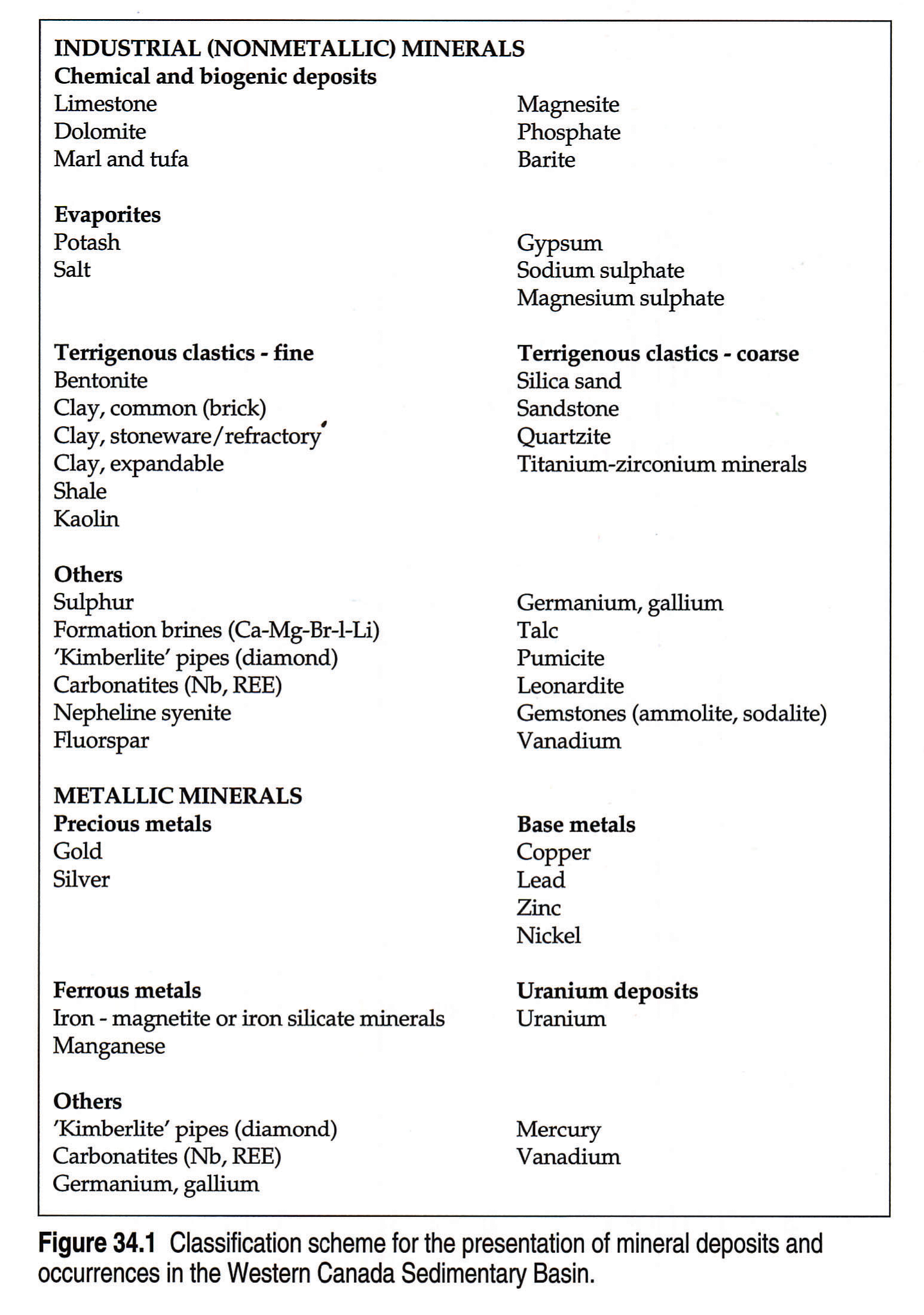
Minerals of the Western Canada Sedimentary Basin are presented according to the scheme outlined in Figure 34.1. The minerals are divided into industrial (or nonmetallic) minerals and metallic minerals. Under these broad categories the minerals are grouped into the various mineral types shown, with each type having common geological characteristics or elemental associations or both. The scheme is not intended as a classification of mineral deposits, merely a convenient way of grouping the various kinds of minerals by geological association.
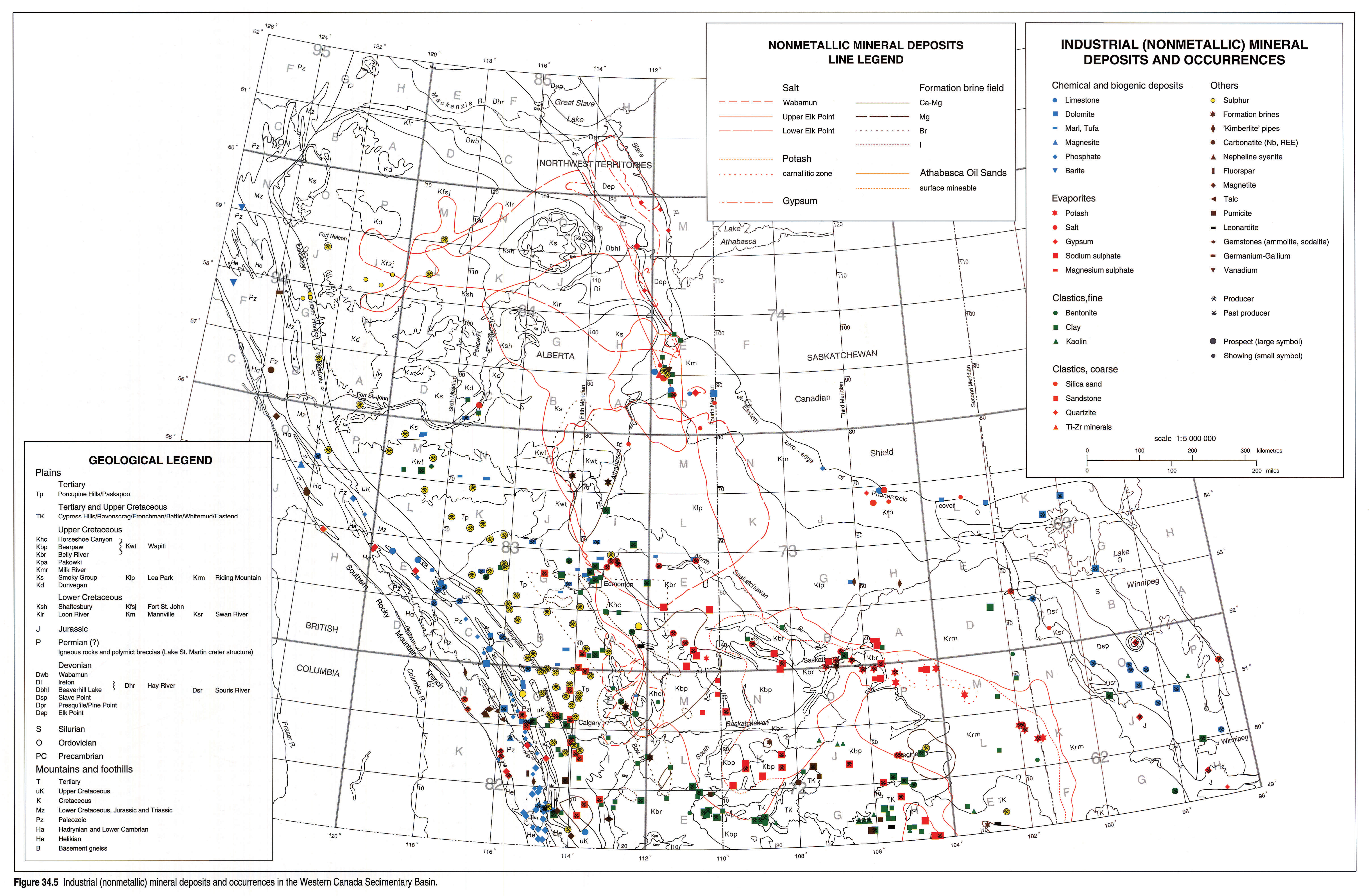
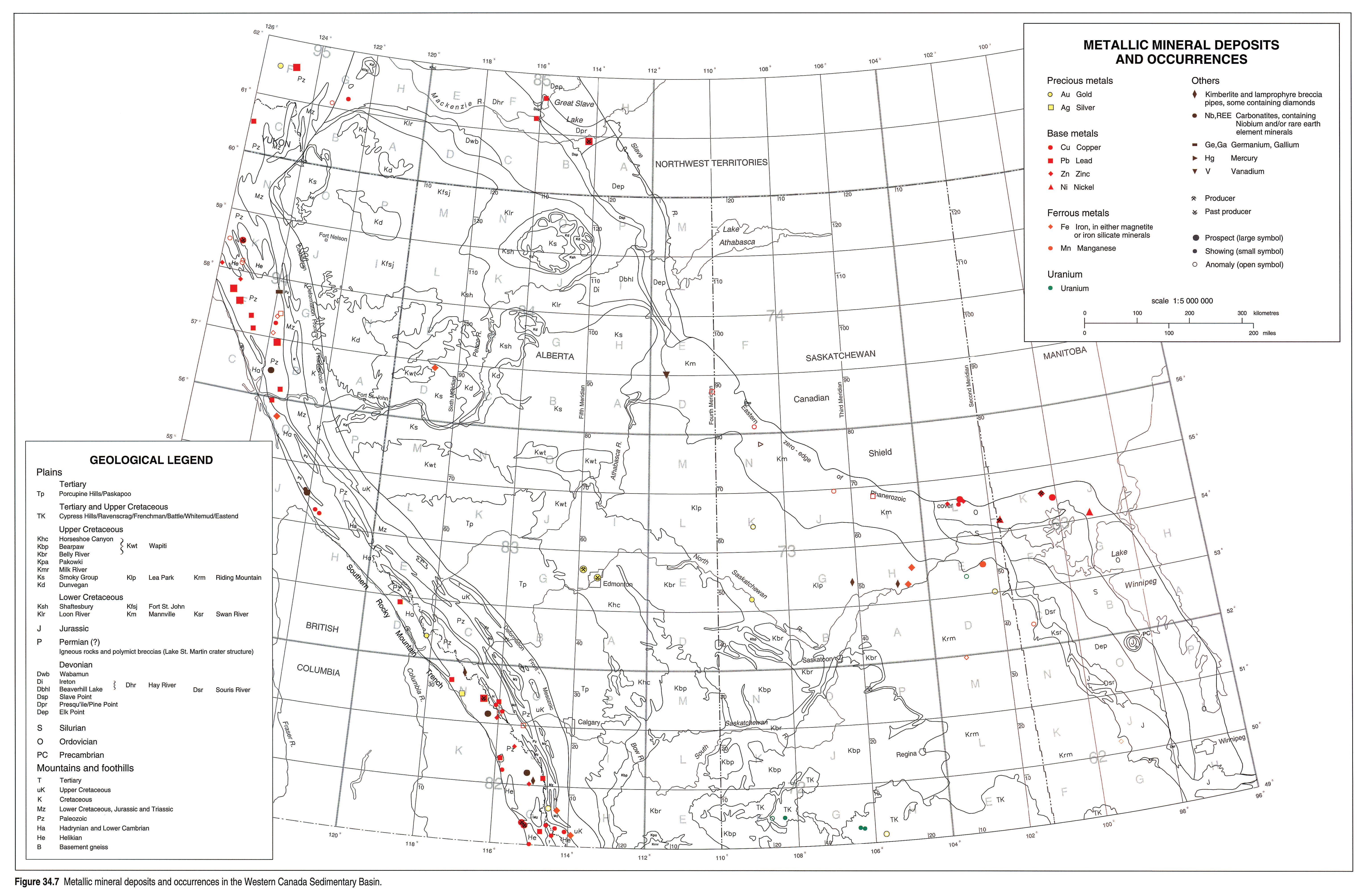
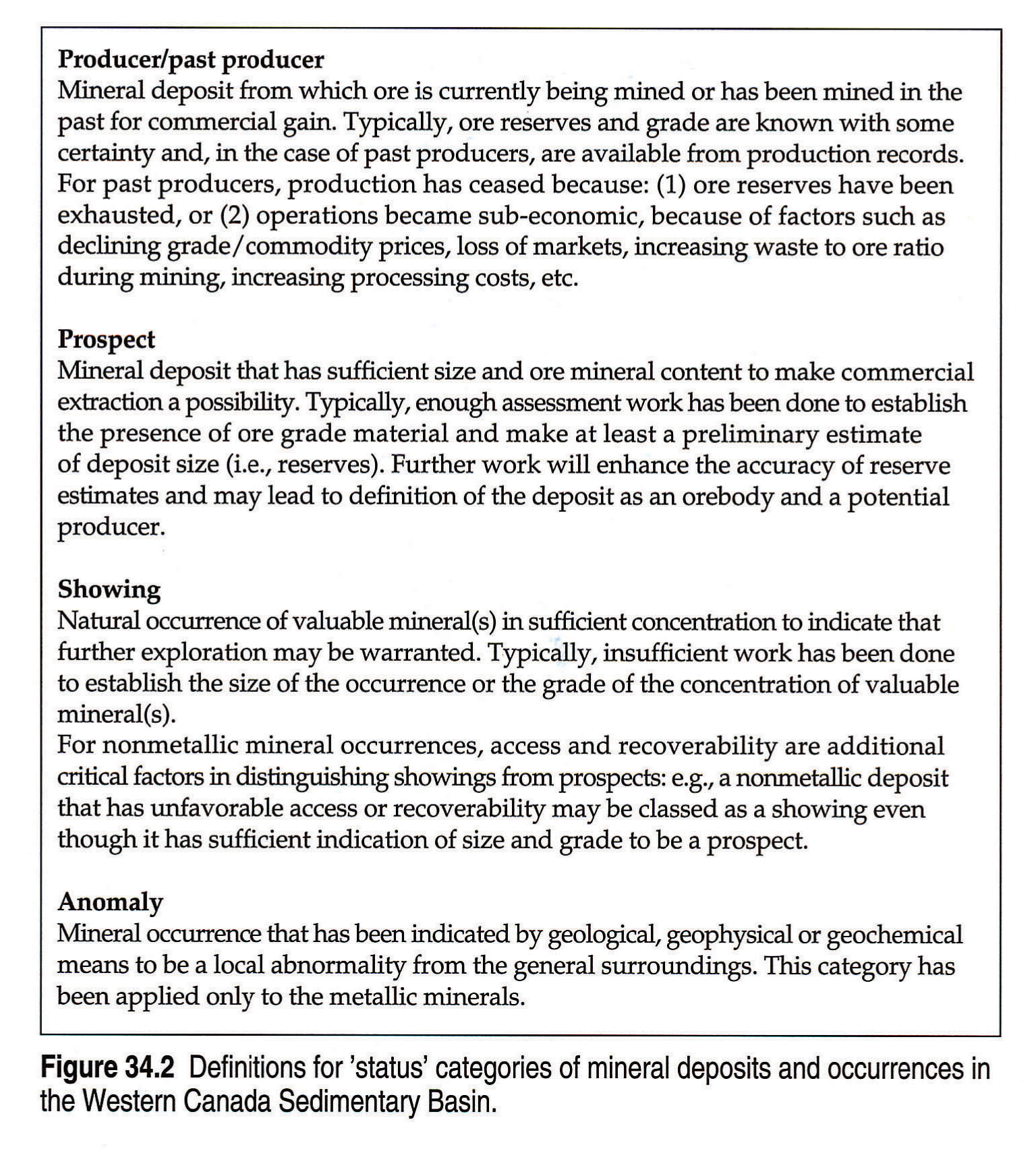
All known deposits and occurrences are presented on geological base maps: Figures 34.5 and 34.7, for the nonmetallic and metallic minerals, respectively. These maps indicate, in most cases, the geological setting for the deposit. In some cases however, the deposit is hosted by a rock unit that exists at depth beneath the unit that crops out. The mineral deposits are displayed in two ways: 1) spot symbols, which are colour-coded according to the scheme of mineral groupings outlined in Figure 34.1, with each symbol representing an individual deposit or cluster of deposits, the actual area of which is too small to show at the map scale; and 2) line symbols, for deposits large enough to be outlined in their true dimensions. The deposits represented by spot symbols are further categorized as to 'status' as follows: 1) producers or past producers, 2) prospects, or undeveloped potential ore deposits, and 3) showings, or significant mineral occurrences. For the metallics, because of the fewer numbers of mineral occurrences displayed on the map (Fig. 34.7), an additional category (anomalies) is included. Definitions for the different 'status' categories are given in Figure 34.2.
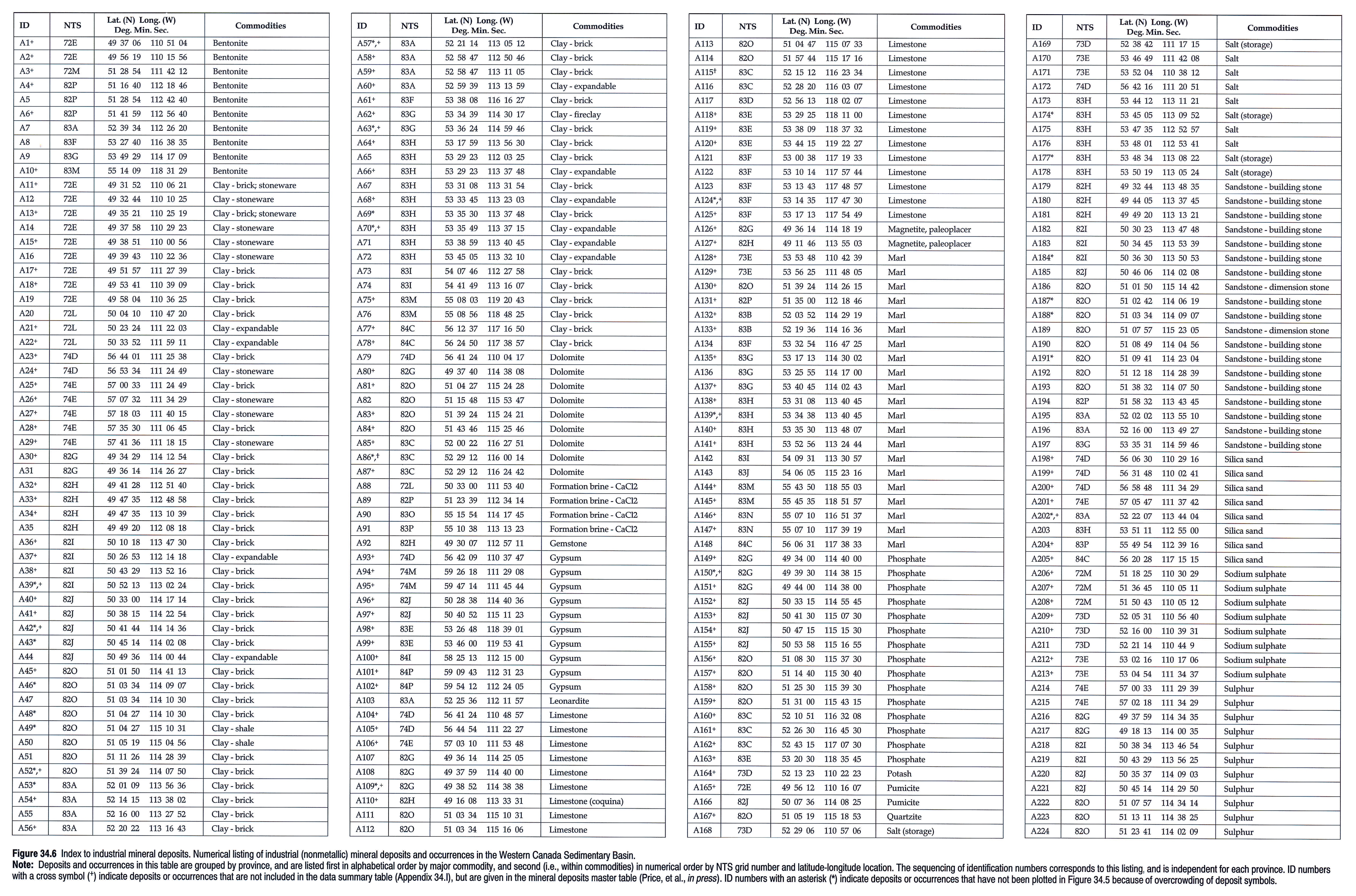
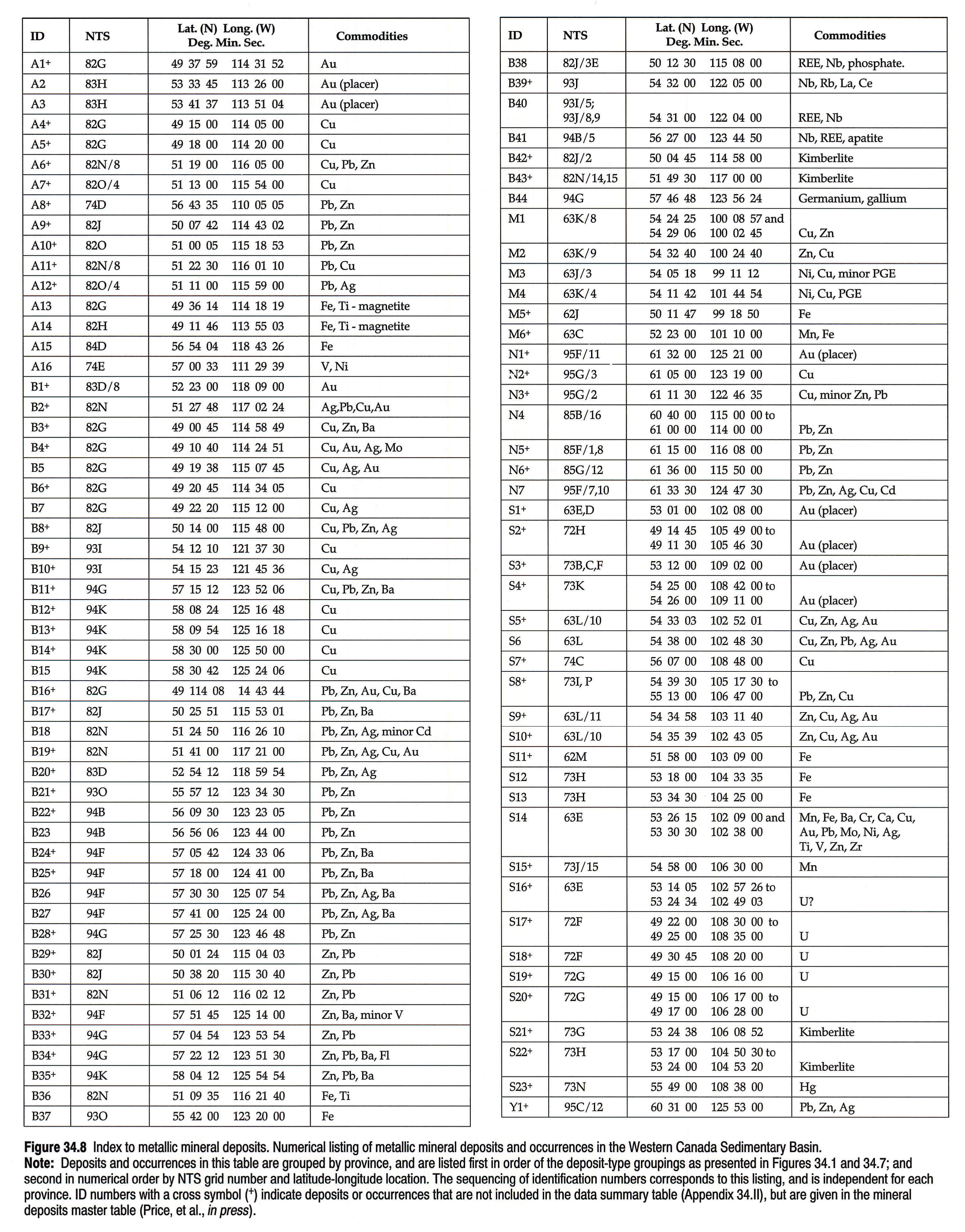
Numerical listings of all deposits and occurrences displayed on the two maps are presented in Figures 34.6 left pane, 34.6 right pane (nonmetallics) and 34.8 (metallics). For the nonmetallics the deposits and occurrences are listed by province, first in alphabetical order by major commodity, and second (i.e., within commodities) in numerical order by NTS grid number and latitude-longitude location. For the metallics the listing is the same except that mineral commodities are arranged in the deposit-type groupings as presented in Figures 34.1 and 34.7. Each deposit or occurrence is assigned an identification number, which includes a one-letter province identifier (A, Alberta; B, British Columbia; M, Manitoba; N, Northwest Territories; S, Saskatchewan; Y, Yukon Territory) followed by a sequential number. The sequencing of ID numbers corresponds to this listing and is independent for each province.
For each deposit or occurrence displayed on the two maps, a synopsis of available data is contained in a mineral deposits master table1. The data include information on geological setting and resource attributes of the deposit, along with pertinent references. Summaries of data for the more important deposits selected from the master table are presented in Appendix I (nonmetallics) and Appendix II (metallics).
Economic Minerals - A Resource Perspective
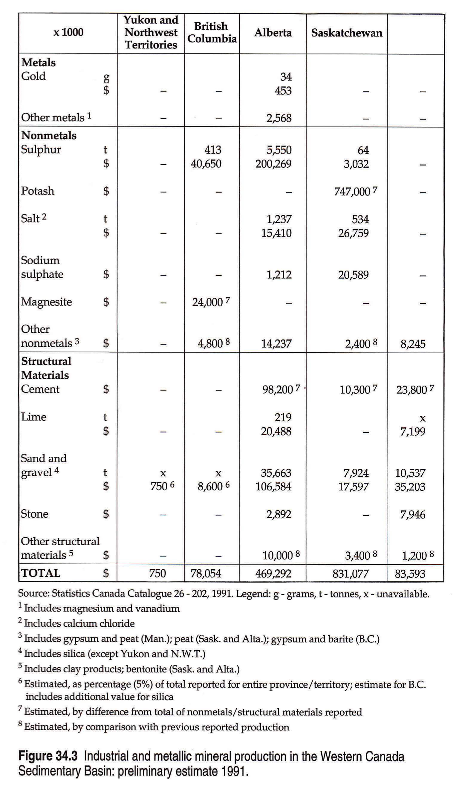
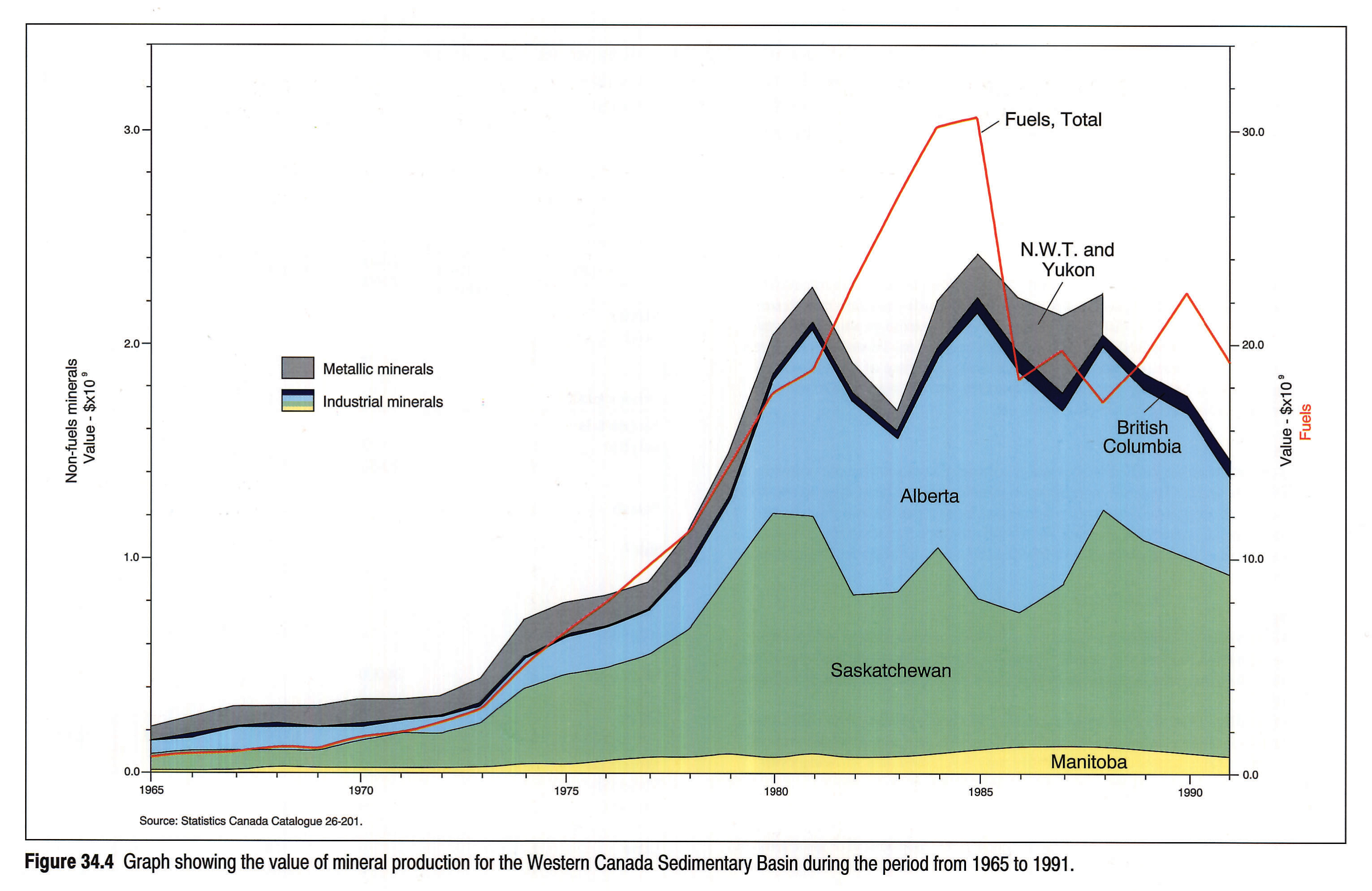
More than 35 different minerals are produced now or have been produced in the Western Canada Sedimentary Basin. Some of the minerals have a long history of production, even preceding that for the fossil fuels. The oldest record of mineral production dates from 1820, when salt was being harvested from saline spring deposits in northeastern Alberta for trade with inhabitants of the region (Allan, 1920). Currently, the annual production of non-fuel minerals in the basin is valued at about $1.5 billion (Fig. 34.3), which is about 7 percent of the region's total mineral production wealth.
Mineral production in the basin region for the past 26 years is shown in Figure 34.4. Since publication of the previous atlas in 1964, the importance of non-fuel minerals has grown enormously. By far the largest in both tonnage and value of production are the industrial minerals - a diverse array of more than a dozen different commodities. In the past 26 years the basin has become the world's second largest producer of potash, second largest producer and largest exporter of sulphur, and a new international supplier of magnesite. Major growth has occurred also in locally consumed minerals for the construction materials and chemical industries. These include production of limestone for cement and lime, sand and gravel for aggregate, gypsum, building stone, brick clay and expandable clay, bentonite, silica, and salt.
The metallic mineral deposits are much less developed in the Western Canada Sedimentary Basin, but also are much less explored. Because of its mainly sedimentary rock regime the basin region has long been regarded as unfavorable for metallics, with the notable exception of lead-zinc from such past-producers as the Pine Point and Monarch-Kicking Horse mines. More recently, recognition of a variety of geological anomalies and some igneous rocks in the basin has touched off new interest in the resource potential for metallics. The main contribution of metallic minerals shown in Figure 34.4 is for lead-zinc production from Devonian strata at Pine Point, N.W.T. This graph records the complete cycle of Pine Point production from its beginning in 1965 to cessation in 1988. Current production of metallic minerals from Phanerozoic basin rocks is limited to minor amounts of placer gold. Two other metallic producers, Spruce Point and Namew Lake in Manitoba, lie within the basin region, but their production is from Precambrian basement rocks beneath the Phanerozoic cover.
Industrial (Nonmetallic) Minerals
The industrial minerals that occur in the Western Canada Sedimentary Basin are shown in Figure 34.1. They are widely distributed throughout the basin (Fig. 34.5) and are found in rock units from every geological period in the Phanerozoic. At least 480 deposits and occurrences of these minerals are known (Fig. 34.6 left pane, 34.6 right pane). Appendix I summarizes available data for deposits that are current or past producers in the region. Data for all deposits and occurrences shown in Figure 34.5 are given in the mineral deposits master table (Price et al., in press).
In the following sections a brief description of geological setting and resource attributes is given for each mineral represented. Reference to specific deposits is given by means of the identification number assigned to the deposit.
Chemical and Biogenic Deposits
This group includes industrial mineral deposits that originated by chemical or biochemical processes within a sedimentary succession, but excludes evaporites. Although evaporites are a type of chemical sediment, they are treated separately because of their unique geological characteristics and economic importance.
Limestone and Dolomite
Limestone is found in all provinces in the Western Canada Sedimentary Basin and is or was produced in all but Saskatchewan. In terms of its primary product usage (cement and lime), limestone is one of the most valuable industrial minerals of the region.
In Manitoba, limestone production from the Devonian Elm Point Formation occurs near Steep Rock (M18) and Faulkner (M17), for use in a cement plant near Winnipeg and a lime plant at Faulkner (Bannatyne, 1984). Another Devonian source of limestone is the Souris River Formation, which is quarried near Mafeking (M20) for cement production at Regina. Devonian limestones extend into Saskatchewan as well, but not in economically quarriable situations, with the possible exception of near-surface deposits near Pinehouse Lake (S51) (Guliov, 1992).
Huge reserves of limestone are exposed in Cambrian, Devonian and Mississippian formations in the Rocky Mountains of Alberta (Holter, 1976). Limestone is exploited currently at six localities. The two largest quarries are at Cadomin (A121) and Exshaw (A111), both producing limestone for cement from the Devonian Palliser Formation. Two other quarries, at Canmore (A112) and Crowsnest Lake (A108), produce from the Carboniferous Livingstone Formation for use in lime making. Two smaller operations, at Nordegg (A116) and at Corkscrew Mountain near Rocky Mountain House (A114), utilize equivalent Carboniferous strata of the Pekisko Formation for a broad range of agricultural and industrial limestone products. Formerly, the Cambrian Eldon Formation was a source of limestone for lime making at Kananaskis (A113). In the Alberta Plains, limestone exposed near the shield margin in the northeast has had no exploitation. Some good grades are reported for Devonian Waterways Formation limestones that crop out along the Athabasca and Clearwater rivers, but quarriable reserves appear limited.
British Columbia has no current limestone production from its part of the basin, although production did occur for a short time from the Carboniferous Rundle Group at Sukunka River (B18) in northeastern B.C. Plentiful resources of chemical-grade limestone remain at this locality.
Dolomite crops out extensively in the Rocky Mountains of Alberta and British Columbia, and in the shield-marginal lowlands of Manitoba, east-central Saskatchewan and northeastern Alberta. Although vast resources of high-purity material are available, little exploitation for chemical use has taken place. Small production of dolomite for use as smelter flux took place at one time from Devonian Fairholme Group strata at Crowsnest Lake, Alberta (A80). The main use of dolomite in the basin has been for building stone and crushed aggregate. One of Canada's most famous building stones is produced from the Ordovician Red River Formation in Manitoba, from quarries at Garson (M14), northeast of Winnipeg. Known as 'Tyndall Stone', the rock is a dolomitic limestone valued for its tapestry-mottled appearance and large fossil forms. It is widely used as facing stone in public buildings.
Other exposures of the Red River and overlying Stony Mountain Formation dolomites occur throughout the Interlake region of Manitoba and parts of east-central Saskatchewan. They have considerable potential as dimension stone. Limited quarrying of the Red River dolomite has occurred in the Limestone Lake area (S41) of Saskatchewan. The dolomites exposed in the mountains of Alberta and British Columbia have little dimension stone potential because of severe jointing and fracturing.
Marl and Tufa
Marl and tufa deposits are numerous in central and northwestern Alberta (Macdonald, 1982), and probably are common in other parts of the basin as well, although not as extensively mapped. The Alberta deposits are generally small, of post-glacial or Recent age, and associated with groundwater discharge areas. A few have sizeable reserves (1 000 000 t) with grades of 65 percent CaCO3 or better. Two of these, at Halfway Lake near Clyde (A142) and at Marlboro (A134), were exploited in the past for cement making, and at least three others (A136, A143 and A148) have had sporadic production for local agricultural liming.
Magnesite
Carbonate-hosted magnesite deposits are known at two localities in the Rocky Mountains in British Columbia (Grant, 1987), including the only producer at Mount Brussilof (B19). This deposit, reputed to be the largest and purest magnesite deposit in the western world, is hosted in Middle Cambrian Cathedral Formation dolomite. It is part of a 15-km long magnesite belt that follows the Cathedral Escarpment (Simandl and Hancock, 1991). Magnesite quarried at Mount Brussilof is shipped to Exshaw, Alberta for processing to caustic calcined magnesia and fused magnesia. Some of the magnesite produced was used also as ore feed for magnesium metal extraction at High River, Alberta (Wheeler, 1992) prior to closure of the plant in 1991.
Phosphate
Phosphates and phosphatic rocks are common in the Rocky Mountains of Alberta and British Columbia. No less than ten formations, ranging from Devonian to Jurassic in age, are phosphate-bearing in the area (Macdonald, 1987; Butrenchuk, in press). However, deposits with grades approaching commercial levels are few, and are limited to the Permian Johnston Canyon and Ranger Canyon formations, the Triassic Whistler Member of the Sulphur Mountain Formation, and the Jurassic Fernie Formation. Best potential lies with deposits in the Fernie Formation in southeastern British Columbia, where large reserves with grades of 18 to 26 percent P2O5 have been identified. No commercial production has occurred to date, except for limited test production at the abandoned Crow mine in Crowsnest Pass (B34). Triassic phosphates in the Monkman Pass-Wapiti Lake area of northeastern British Columbia are comparable in grade and thickness to the phosphates in the Fernie Basin.
Barite
Barite is found in Western Canada Sedimentary Basin strata only in British Columbia. Known deposits include both vein and bedded replacement types in Cambrian, Ordovician and Devonian rocks (Butrenchuk, 1989a). In southeastern British Columbia barite is found as veins, pods and lenses in Cambrian Jubilee Formation dolomites (B1). In northeastern British Columbia the occurrences are in Devonian strata. At Muncho Lake (B3), for example, barite beds up to 33 m thick occur in a zone between Wokkpash Formation sandstone and overlying Stone Formation dolomite.
Production of barite has occurred in southeastern British Columbia intermittently since 1940, mostly from vein deposits at Parson and Brisco, but with some from replacement deposits near Spillimacheen and Invermere (Hora, 1983). These deposits lie west of the western structural boundary of the Rocky Mountains, outside the study area for this Atlas, though their host rocks are equivalents or extensions of sedimentary units in the Western Canada Sedimentary Basin.
Evaporites
Evaporites are of major importance in the Western Canada Sedimentary Basin as economic mineral source rocks, giving rise directly to deposits of potash, salt and gypsum, and having indirect implications in the presence of sulphur deposits. Although evaporites abound stratigraphically in the basin, the Middle Devonian Elk Point Group and equivalents stand out as the most important. Jurassic evaporites are important in the eastern region (for gypsum). Recent evaporites give rise to surficial deposits of sodium and magnesium sulphates.
Potash
Potash underlies an extensive area of southern Saskatchewan, with projections into southwestern Manitoba and eastern Alberta (Fig. 34.5). All current production is in Saskatchewan, where its annual value in recent years has exceeded that of any other industrial mineral product for the entire country. The potash occurs in the Prairie Evaporite Formation, the uppermost evaporite unit of the Elk Point Group. This formation is extensive throughout the plains region, with thicknesses of up 200 m. It consists primarily of salt (halite) in Alberta, but is richly mineralized with potash in the central part of the evaporite basin (in Saskatchewan).
The potash occurs in the upper 60 m of the formation, in four members separated by salt beds (Holter, 1969). The members range from 6 to 15 m in thickness and contain individual potash beds up to 7 m thick. They extend more or less continuously across the basin in Saskatchewan, although interruptions due to solution channeling occur. Depths to the uppermost potash member range from 885 m in the northeast to more than 1500 m in the Regina-Moose Jaw area. The principal minerals are halite, sylvite and carnallite.
Potash mining is conducted at ten sites in Saskatchewan, eight of which are conventional underground mines and two of which are solution mines (Guliov, 1992). Three of the conventional mines are located in the Esterhazy-Rocanville area near the eastern border (S56, S57, S58), exploiting the lowermost Esterhazy Member. In the Saskatoon-Lanigan area, five conventional mines (S61, S64, S65, S66, S68) and one solution mine (S67) exploit the uppermost Patience Lake Member. At Belle Plaine (S60) near Regina, solution mining is used to exploit a third potash member, the Belle Plaine, which underlies the Patience Lake Member. The potash beds at this site are too deep (1500 m) for conventional underground recovery, which in practice is limited to a depth of about 1100 m.
Saskatchewan potash resources are among the largest and richest known in the world. Estimates range upward from 56 billion tonnes with grades of 25 percent K2O equivalent or better, counting conventional and solution mining recoverable reserves (Guliov, 1992).
Salt
Salt deposits have enormous extent in the Western Canada subsurface (Fig. 34.5). The major deposits belong to the Elk Point Group, a succession of strata composed dominantly of thick salt beds which reach an aggregate thickness of 430 m in one area of the basin (Hamilton, 1971). Two distinct types of salt deposits are found in the Elk Point Group, corresponding to well defined upper and lower subdivisions. The Upper Elk Point contains the Prairie Evaporite salt, by far the most extensive deposit, which underlies half of Alberta, most of the southern third of Saskatchewan and part of southwestern Manitoba, in thicknesses up to 200 m. The salt varies considerably in purity within the basin, in a manner reflecting 'normal' marine evaporite deposition (progressing to the potash phase in the basin centre).
Salt in the Lower Elk Point is more restricted in distribution, although it too is very thick and extensive in east-central Alberta. It occurs in three separate deposits: Lower Lotsberg, Upper Lotsberg and Cold Lake salts. These deposits differ from Prairie Evaporite salt in their chemical and mineralogical makeup, reflecting an 'abnormal' history of solution and redeposition that has resulted in extraordinarily pure beds of salt.
Salt beds dip homoclinally across the plains, from a depth of 210 m at Fort McMurray in the northeast, to 1820 m at Edmonton. Salt production presently occurs at eight sites in the basin, and all but one involve solution mining. Four of the producing areas are in Saskatchewan, one of which is a potash mine at Esterhazy (S74) that supplies by-product salt for ice control. The others are brining operations: at Unity (S77) and at Belle Plaine (S75), which produce evaporated salt for domestic and agriculture use; and at Saskatoon (S76), which produces brine for chloralkali chemicals manufacture. These operations all exploit the Prairie Evaporite deposit.
In Alberta, salt is brined from the Upper Lotsberg at three sites in the Fort Saskatchewan-Bruderheim area (A173, A175, A176) for chemicals manufacture, and from the Prairie Evaporite at Lindbergh (A171) to produce evaporated salt for domestic and industrial markets. Elk Point salts are also used at several localities in Alberta and Saskatchewan for underground storage of petroleum products in artificial caverns (A168, A169, A174, A177, A178). Previously in Alberta, salt was produced from the Prairie Evaporite at Fort McMurray (A172) and from the Upper Lotsberg at Duvernay (A170), but these operations ceased some years ago.
Gypsum
Gypsum occurs in all provinces in the Western Canada Sedimentary Basin, but is exploited only in Manitoba and British Columbia. In Manitoba, surface deposits are quarried at localities near Amaranth (M12) and at Gypsumville (M13), from the Jurassic Amaranth Formation (Bannatyne, 1984). At Amaranth, the gypsum beds are about 6 m thick under 6 m of glacial overburden. At Gypsumville, the deposits are preserved within an impact crater 25 km in diameter (Lake St. Martin structure) and occur as isolated ridges rising above swamp. Previously, gypsum was mined underground at Silver Plains (M11), and also from the Jurassic Amaranth Formation at a depth of 50 m. Manitoba gypsum supplies wallboard plants in Winnipeg, Saskatoon and, at times, Edmonton. Some of the production is used also in cement manufacture at plants in Winnipeg and Regina.
British Columbia production comes from the Windermere-Canal Flats area of the Rocky Mountains (Butrenchuk, 1989b). The gypsum deposits are in the Middle Devonian Burnais Formation and are equivalent in age to evaporites of the Lower Elk Point subgroup, although depositionally quite separate and distinct. The deposits are structurally disturbed, occurring as sections of steeply dipping, contorted, gypsiferous strata 200 m or more in thickness. Quarrying takes place at two sites: the Elkhorn quarry near Windermere (B13) and the Lussier River quarry near Canal Flats (B11). Production is shipped to wallboard plants in Vancouver, Calgary and Edmonton, and to cement plants in Exshaw and Edmonton.
Alberta has a number of gypsum deposits of Devonian and Triassic ages (Hamilton, 1982). These are undeveloped, owing to their remote locations or difficult accessibilities, but at least two have future development potential. The prospective deposits are near-surface projections of Elk Point and associated Fort Vermilion Formation evaporites in northeastern Alberta, near Fort McMurray (A93) and at Peace Point on the Peace River (A101).
Sodium and Magnesium Sulphates
Sodium sulphate deposits are numerous in southern Saskatchewan and southeastern Alberta (Broughton, 1984), and have been commercially exploited for many years. They are alkali lake deposits of Recent age, formed by evaporation in enclosed drainage basins under fairly arid conditions. The deposits occur as lake brines and as intermittent or permanent crystal beds comprised dominantly of sodium sulphate, with lesser amounts of magnesium salts. Mirabilite SO4 is the most abundant mineral to form in the crystal beds, which are normally interlayered with silt, clay, and organic matter. The beds typically are 1 to 5 m thick, although some greater than 30 m are known, and have grades in excess of 90 percent mineral salts. Many of the deposits are small, but 22 have indicated reserves of 500 000 t or greater, the largest at Ingebright Lake South (S92) having 9 million tonnes.
Seven sodium sulphate production plants were in operation in 1991, six of these in Saskatchewan (S86, S88, S92, S94, S95, S102). The product is used primarily in kraft pulp mills, with a small proportion going to the manufacture of detergents. These markets are declining, and two of the Saskatchewan plants (S94, S95) and the lone Alberta plant (A211) ceased operation during 1991.
No production of magnesium sulphate has occurred from alkali lakes in either Saskatchewan or Alberta. However, some of the Saskatchewan lake brines are enriched in magnesium salt, at the expense of sodium sulphate, and contain substantial resources. Most notable of these is Big Quill Lake (S53), with reserves of 2 million tonnes of magnesium sulphate (Guliov, 1992).
Terrigenous Clastics
This group of industrial minerals is divided in Figure 34.1 into fine and coarse, to correspond to the major rock-type distinction between clay-size and sand-size clastic rocks. The distinction relates also to major differences in physical properties of the industrial minerals derived from these rock types.
Bentonite
Bentonite is common in Upper Cretaceous rocks throughout the basin region, but economic deposits are rare. Only three localities are currently producing. Sodium (swelling) bentonite is produced near Rosalind, Alberta (A7) from the non-marine Horseshoe Canyon Formation, and near Truax, Saskatchewan (S4) from the marine Bearpaw Formation. The bentonite is used in foundries, drilling muds, for pelletizing, and for sealing reservoirs. Calcium (non-swelling) bentonite is produced at Thornhill (M1) near Morden, Manitoba, from the Pembina Member of the Vermilion River Formation. It is used as a decolorizing and absorbing agent for mineral and vegetable oils, and as a binder in feed pellets and foundry sand. Other deposits of swelling bentonite are known in the Bearpaw and Horseshoe Canyon formations of central Alberta, and of non-swelling bentonite in the Ravenscrag and Battle formations in southern Saskatchewan.
Clay and Shale
Clay and shale occur in virtually all of the Mesozoic and Cenozoic formations exposed in the basin region. The clay rocks have been widely exploited at various times in the past for structural clay products, cement, and lightweight (expanded clay) aggregate manufacture. All provinces except British Columbia are producing or have recently produced clay from basin rocks.
In general, the better grades of ceramic clay in Western Canada are found in non-marine bedrock formations, among which the Upper Cretaceous Whitemud Formation has been the principal source. The Whitemud is a thin (up to 30 m) but extensive unit that underlies a large area of southern Saskatchewan and part of southeastern Alberta in the Cypress Hills area. Clays in this formation are kaolin based and include plastic, stoneware, ball and china clay. Ceramic products derived from these clays include flue linings, sewer pipe, refractory brick, common and face brick, and pottery. The Whitemud Formation is also a potential source of filler-grade kaolin.
In Saskatchewan, clay production from the Whitemud Formation occurs near Eastend (S14), for use in structural clay products and pottery making at Medicine Hat, Alberta; in the Wood Mountain-Flintoft area (S15, S16, S17, S18), for brick making at Estevan; and in the Dirt Hills-Cactus Hills area near Claybank (S29), for brick making at Regina. Other sources of clay include the Paleocene Ravenscrag Formation and certain glacial lacustrine deposits. Production from the Ravenscrag in the Willow Bunch-Rockglen area (S15) is used in the Estevan brick plant and also for earthenware and stoneware products. Local glacial clays are used for lightweight aggregate production at Regina (S31) and Saskatoon (S37), and for cement making at Regina.
In Alberta, Whitemud Formation clay is quarried in the Cypress Hills area (A12, A16) for use mainly in brick making at Medicine Hat. At Edmonton, local glacial clays are combined with similar clays from Athabasca (A74) for brick making. Clays from the Upper Cretaceous Scollard Formation near Wabamun (A62), and from the Battle Formation in the Cypress Hills area, have had limited trial use for low-alkali cement manufacture. Shales from the Upper Cretaceous Wapiabi (A50) and Belly River formations are quarried for cement manufacture at Exshaw. Shale from the Paleocene Porcupine Hills Formation is quarried from pits at DeWinton just south of Calgary (A44) for lightweight aggregate production. Other significant past exploitation of Alberta clay rocks includes the use of glacial clays for expanded aggregate in Edmonton (A71), and the use of dolomitic shale from the Carboniferous Banff Formation for mineral wool production near Exshaw (A49).
In Manitoba, Jurassic and Cretaceous shales have been quarried in the Pembina Mountain and Ste. Rose du Lac areas (M3) for use in a brick plant at Lockport, which closed in 1990. Glacial lake clays are used for cement and expanded aggregate production in plants near Winnipeg (M2).
Kaolin
Deposits of kaolin in the Western Canada Sedimentary Basin are found principally in the Upper Cretaceous Whitemud Formation. No production of kaolin in the 'pure commodity' sense has occurred, although many of the produced industrial ceramic clays are kaolin-rich. In southern Saskatchewan, the Whitemud Formation comprises a lower kaolinized sand member and an upper plastic clay member (Guliov, 1992). In the Wood Mountain area (S17), the lower member contains 50 to 60 percent kaolin. Research and development work has shown the kaolin component to be potentially separable and upgradable to a commercial filler-grade product. The kaolin reserves in the area are large, close to 200 million tonnes (Master, 1987).
Silica Sand and Quartzite
Silica deposits are widely scattered in Western Canada in rocks of Ordovician, Cretaceous and Recent ages, and production of silica occurs in all provinces (Collings and Andrews, 1989). In Manitoba, silica sand is quarried on Black Island in Lake Winnipeg (M22), from the Ordovician Winnipeg Formation. The sand is a high-purity product and was used until recently for glass manufacture in Redcliff, Alberta; its current uses include foundry and filter-bed sand, and sandblasting. Another high-purity deposit near Beausejour, Manitoba has been produced periodically for use in glass making, sand-lime brick and other constructional uses. This is a post-glacial deposit and is believed to have been derived from Ordovician Winnipeg Formation sand. Other potential deposits are present in the Lower Cretaceous Swan River Formation near Swan River (M23).
In Saskatchewan, the Lower Cretaceous Mannville Formation (Swan River equivalent) contains high-purity silica deposits in the Red Deer River area (S78) and near Wapawekka Lake (S82). Only in the Red Deer River deposit has production occurred, the product for use as golf course sand. Another deposit in the same area, at Hanson Lake (S79), is in the Ordovician Winnipeg Formation. This sand has had limited use as flux for nonferrous metal smelting at Flin Flon, Manitoba, and has been investigated as a hydraulic fracturing sand.
Alberta's lone silica producer is a Recent dune sand deposit near Bruderheim (A203). The sand is relatively low-grade material derived from reworked glacial deposits and is used mainly for fibreglass manufacture. Higher grade resources are known in northern Alberta, in deposits of Early Cretaceous age, but are undeveloped. These include the McMurray Formation sands that arise as tailings from oil sands processing (A200), and highly quartzose marine sands in the Peace River (A205) and Pelican (A204) formations.
The Ordovician Mount Wilson Formation is the source of high-grade silica at two production sites near Golden in British Columbia. The formation crops out along a narrow, 50 km long belt in southeastern B.C. and for most of its length comprises massive white quartzite. At Nicholson (B44), the quartzite is quarried and crushed to produce lump silica for ferrosilicon manufacture in Washington state. At Mount Moberly (B46), on the northern end of the belt, the quartzite unit includes a friable sandstone phase that allows for the production of granular silica. The product is used for glass manufacture at Vernon, B.C. and for various silica sand markets in Western Canada, including golf course sand. Another high-grade silica resource, albeit undeveloped, occurs near Longworth in northeastern B.C., in quartzite of the Silurian Nonda Formation (B45).
Sandstone
Sandstones in the Western Canada Sedimentary Basin have had limited industrial use. Most have poor durability for use as a building stone, or even for riprap. The only sandstone currently exploited in the basin is found in the Triassic Spray River Formation. It is fine grained and grades to siltstone. This rock is quarried near Canmore in the Alberta Rocky Mountains (A186, A189), where it is known as `Rundle Rock'. The rock is dark gray and flaggy, and is used primarily for rough building stone and patio stone. Another Alberta sandstone, which had significant past use, is known as `Paskapoo Sandstone'. The rock is a weak, friable sandstone from the Paleocene Paskapoo and Porcupine Hills formations. As many as 20 quarries of this stone were once operated (Godfrey, 1986). Limited use is still made of Paskapoo Sandstone for restoration of historic Alberta buildings originally constructed of this material, particularly in Calgary.
Titanium-zirconium Minerals
Heavy minerals that exist in trace amounts in Lower Cretaceous McMurray Formation oil sands are rich in titanium minerals and zircon. The `heavies' become concentrated in the secondary tailings stream during oil sands processing at Fort McMurray. The concentration level is such that these tailings are comparable in tonnage and grade to world-scale mineral sands deposits worked commercially for titanium and zirconium minerals recovery (Trevoy, 1984). However, commercial development has not yet occurred for the oil sands tailings.
Sand and Gravel
Construction sand and gravel rate among the most important industrial minerals in the Western Canada Sedimentary Basin in terms of total production value. Deposits are widely dispersed in all provinces and production occurs at hundreds of sites. Because of the abundance of sand and gravel deposits and operations throughout the region, they are not presented in Figure 34.5.
Sand and gravel are hosted primarily in the surficial mantle of the basin region. They occur in three main geological categories: preglacial, glacial, and Recent alluvial (Edwards, 1992). By far the most common are the glacial deposits, which comprise mainly outwash but also include ice-contact and glacio-lacustrine deposits. The latter are important aggregate sources in southern Manitoba and eastern Saskatchewan, where they occur as extensive beach deposits. Preglacial deposits are of local importance in Alberta and Saskatchewan. They are found both as channel fill in bedrock channels (e.g., at Villeneuve, Alberta), and as Tertiary gravel cappings on bedrock uplands (e.g., at Hand and Wintering hills in Alberta, at Cypress Hills in Alberta and Saskatchewan, and in the Swift Current and Wood Mountain areas in Saskatchewan). Recent alluvial deposits are less common, but are worked in many places, generally on river terraces, and account for a major share of the production.
Other Industrial Minerals
This category includes minerals of various geological origins that are not classifiable in any of the previous categories. Some are the result of fluid-rock interactions (sulphur, formation brines); some are metamorphic (talc), pyroclastic (pumicite), and alteration products (leonardite); and some are commodity specialties (gemstones).
Other industrial minerals that belong to this category but have strong overlapping ties with the metallics are discussed under Metallic Minerals. These are mostly minerals that are the result of igneous emplacement (diamondiferous `kimberlites'; niobium-, rare earth- or fluorspar-bearing carbonatites; nepheline syenite; germanium-gallium; and some magnetite deposits); they also include a paleoplacer (magnetite) and a bitumen byproduct (vanadium).
Sulphur
Sulphur is widespread in the Western Canada Sedimentary Basin, primarily in the form of hydrogen sulphide dissolved in natural gas in subsurface reservoir formations. The basin is the world's second largest producer of sulphur; most of it as by-product or co-product of sour gas production from Devonian and Carboniferous carbonate reservoirs. The sulphur is recovered in more than 50 sulphur extraction plants in Alberta (A216 to A268), four in northeastern British Columbia (B47, B48, B49, B56), and one in Saskatchewan (S104). A small but significant proportion (about 9 percent) is recovered from synthetic crude oil extracted from the Athabasca oil sands (A214, A215).
Sulphur production from sour gas has declined from the peak years of 1980-85 because of depletion of `conventional' resources (i.e., gas fields with H2S concentrations less than 50 percent and mostly in the range of 3-20 percent). However, potential new resources exist in the form of `ultra sour' gas (70-90 percent H2S), and the technology for extraction of these resources is under pilot plant development at the Bearberry field in the southern Alberta Foothills (A230). If the recovery technology proves feasible, reserves from the Bearberry field alone could double the recoverable sulphur reserves in Western Canada, which are estimated currently at about 100 million tonnes.
A prospective future source of sulphur in Western Canada is native sulphur found in carbonate-evaporite successions of Devonian, Carboniferous and Triassic ages in Alberta and British Columbia (Hora and Hamilton, 1992). Several intersections of native sulphur in Middle Devonian rocks are recorded in wells of northeastern B.C. (B50 to B55), and one occurrence in the Upper Devonian Wabamun Group near Camrose, Alberta (A241) has been intensively prospected.
Formation Brines
Formation waters enriched in calcium, magnesium, bromide, iodide and lithium have been mapped in the Alberta subsurface (Hitchon, 1984), and are known to exist elsewhere in the basin region (Fig. 34.5). Formation brines in Devonian reservoirs (Keg River and Beaverhill Lake formations) are currently exploited at four localities in Alberta for calcium chloride production: two near Slave Lake (A90, A91), one at Drumheller (A89), and one at Brooks (A88). In Saskatchewan, calcium chloride brine seeping into the PCS potash mine near Saskatoon (S44) is recovered and marketed (Buchinski, 1988). The source of this Ca- and Mg-enriched brine is believed to be the Middle Devonian Dawson Bay Formation. Similar brines are found in Middle Devonian carbonate reservoirs elsewhere in the Elk Point Basin in Saskatchewan (Guliov, 1992).
Talc
Talc in the Western Canada Sedimentary Basin was reported by Spence (1940) in Cambrian Cathedral Formation strata at three localities west of Banff, Alberta. All are within National Park territory. The Silver Moon deposit (B57), just west of Vermilion Pass in British Columbia, was worked to a small extent before 1930. The Gold Dollar (B58) and Red Mountain (A269) deposits lie near the B.C.-Alberta boundary in the vicinity of Redearth Pass. Red Mountain was prospected in 1944 as a wartime strategic material source, but was never developed.
Pumicite
Pumicite deposits are reported in numerous localities in Saskatchewan and Alberta, and range in age from Upper Cretaceous to Quaternary. Most are too thin and limited in extent to be of economic interest, but at least three of the Saskatchewan deposits appear large enough for commercial development (Guliov, 1992). These are the Rockglen (S69) and Duncairn (S71) deposits of Eocene-Oligocene age, and the St. Victor (S70) deposit of the Paleocene Ravenscrag Formation. Only one Alberta deposit has any sizeable extent. This deposit is in the Upper Cretaceous Bearpaw Formation near Irvine in the Cypress Hills area (A165). Reported past development of pumicite in the basin relates to small tonnages mined during the 1930s and 1940s from localized deposits at Waldeck, Saskatchewan (S73) and at Willow Creek near Nanton, Alberta (A166), for use in abrasive cleansers.
Leonardite
Deposits of leonardite, which comprises humic acid-rich material formed from oxidation of low-rank coal, are found extensively in southern Saskatchewan and, to a lesser extent, in central Alberta. The Saskatchewan deposits are associated with Paleocene Ravenscrag Formation lignites in the Estevan (S48) and Willow Bunch (S49) coal fields. There is no commercial production from these deposits, but small-scale production has occurred at the Paintearth mine (A103) in the Battle River area of Alberta, from deposits associated with Upper Cretaceous Horseshoe Canyon Formation coals. The main use has been for drilling mud conditioning.
Gemstones
Gemstones are not common in rocks of the Western Canada Sedimentary Basin. Nonetheless, a thriving industry exists in Alberta based on production of `ammolite', a gem-quality material extracted from the shells of ammonites (specifically, Placenticeras). Production is from a richly fossiliferous zone in the Upper Cretaceous Bearpaw Formation that crops out along St. Mary River in southern Alberta (A92).
Gem-quality sodalite is found in British Columbia in nephelene syenites that have intruded basin rocks. No production occurs, but at least one prospect exists in the Ice River complex south of Field (B9).
Resource Aspects of Industrial Minerals
Major industrial mineral products for the different provinces in the Western Canada Sedimentary Basin region are summarized in Figure 34.3. By far the bulk of the production value comes from four primary commodities: potash, sulphur, limestone (in cement and lime), and construction aggregates (mainly sand and gravel). These four commodities accounted for 90 percent of the total industrial mineral production value in 1991, with potash and sulphur together accounting for almost 70 percent. The balance is spread among the many minerals4 discussed in the foregoing sections.
The total value of industrial mineral production for the region is about one third of that for all of Canada. This high proportion is misleading, however, because the region is one of relative industrial immaturity. Potash and sulphur, which account for the bulk of the total value, are both sold largely on the export market. Most of the other commodities are dependent on industrial markets within the region, and accordingly are only minimally developed. Potential for expanded production exists for practically all the minerals, but the realization must await further industrial growth within the region or the securing of markets without.
In addition to the above, there are minerals in the basin that have been produced in the past but are not currently produced, and minerals that have been prospected but not yet developed. Some of the more important of these, in terms of 'value added' and competitive marketing potential, include: potash in Manitoba; kaolin, Mg brines, leonardite, and diamonds in Saskatchewan; Ti-Zr minerals, native sulphur, and diamonds in Alberta; and phosphate, native sulphur and carbonatite-hosted Nb-rare earth elements-fluorspar in British Columbia.
Metallic Minerals
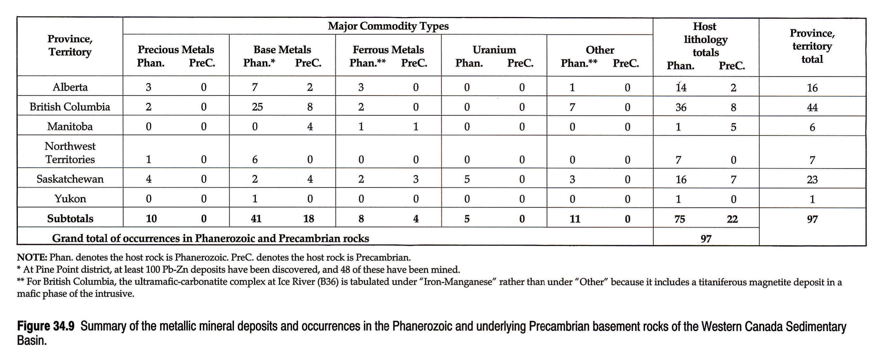
There are at least 97 metallic mineral occurrences in Phanerozoic strata of the Western Canada Sedimentary Basin or in underlying Precambrian basement rocks (Figs. 34.7 and 34.8). A synopsis of the available data for each metallic mineral occurrence is given in the mineral deposits master table (Price et al., in press). Appendix II presents an extract of these data for deposits that have current or past production and for occurrences that are classed as prospects. Figure 34.9 summarizes the occurrences by province or territory, by major commodity, and by whether the host is Phanerozoic strata or Precambrian basement rocks.
The following discussion of the characteristics of the mineral occurrences uses the report by Eckstrand (1984) as a guide to deposit type.
Precious Metals
Seven of the ten precious metal occurrences are placer gold in Recent or Pleistocene river gravels in Alberta, Saskatchewan and the Northwest Territories (A2, A3, S1 to S4, N1)5. Past production typically consists of a few tens of kilograms of gold or less at a few occurrences. The bedrock sources of the placer gold are unknown.
The other precious metal occurrences comprise: 1) gold-bearing quartz veins that cut Lower Cambrian quartzitic rocks near Athabasca Pass, British Columbia (B1); 2) anomalous concentrations of up to 0.21 g Au/t in Lower Cretaceous volcanic rocks in southwestern Alberta (A1); and 3) silver-bearing galena-tetrahedrite-quartz veins in southeastern British Columbia (B2).
Base Metals
Base metals make up the most abundant type of metallic occurrences in the Western Canada Sedimentary Basin. There are at least 59 such occurrences: eight occur in Precambrian basement rocks underlying Phanerozoic strata in either Saskatchewan or Manitoba, ten are in Precambrian sedimentary rocks that crop out in the Cordillera of British Columbia and Alberta, and the remaining 41 are hosted by Phanerozoic strata (Fig. 34.9).
Six of the eight base metal occurrences that exist in Precambrian basement rocks comprise stratiform volcanic-associated massive sulphide deposits (S5, S6, S9, S10, M1 and M2). The other two are magmatic ultramafic-associated nickel-copper deposits with minor amounts of platinum group elements (M3 and M4). The Spruce Point mine (M2) and the Namew Lake mine (M4) in Manitoba were in production as of 1990, and the McIlvenna Bay deposit (S6) at Hanson Lake South in Saskatchewan is awaiting a decision to take it into production.
With respect to the ten base metal occurrences in Precambrian rocks in the Cordillera, four of these (B5, B7, B13 and B15) comprise copper-bearing quartz-carbonate veins in Helikian limestone and dolostone in southeastern and northeastern British Columbia. Five occurrences (A4, A5, B3, B4 and B6) comprise stratabound sediment-hosted disseminated chalcocite, chalcopyrite and bornite in Helikian arenites in southeastern British Columbia and southwestern Alberta. The other occurrence (B20), east of Valemount, British Columbia, consists of galena-sphalerite-quartz veins in quartz conglomerate of unknown, but probable Proterozoic age. The most important past-producer is the now closed Churchill Copper mine (B15) in northeastern British Columbia, which produced 14 670 000 kg of copper between 1970 and 1975. A small amount of copper has been produced also from the Peacock Copper (B7) and Burton (B5) deposits in southeastern British Columbia.
Phanerozoic rocks host at least 41 base metal occurrences in the Western Canada Sedimentary Basin. These occurrences are of several diverse types, including: 1) stratabound Mississippi Valley type lead-zinc deposits, 2) stratiform sediment-hosted sulphide-barite deposits, and 3) vein-type and breccia-fill sulphide showings. Mississippi Valley type Pb-Zn deposits have been the most economically important base metal occurrences. Examples of this type include the past-producers, Pine Point (N4) and Monarch-Kicking Horse mines (B18), the undeveloped prospect at Robb Lake (B23), and numerous small occurrences in Alberta, British Columbia, the Northwest Territories and Saskatchewan. All the Mississippi Valley type Pb-Zn occurrences exist in Cambrian to Devonian carbonate rocks, and they range in size from minor occurrences to major past-producers, with the largest being Pine Point (N4). Between 1964 and 1988 about 62 million tonnes of ore with an average grade of 2.7 percent Pb and 6.4 percent Zn were mined from 48 separate deposits in Middle Devonian strata in the Pine Point district, generating in excess of $334 million in dividends (W.A. Gibbins, pers. comm, 1991). All of these 48 deposits, with the exception of two underground operations, were mined by open-pit methods.
The stratiform sediment-hosted (`Sedex') sulphide-barite deposits in Phanerozoic strata are an important potential source of lead-zinc-silver. At the Cirque deposit (B26) in northeastern British Columbia, for example, reserves are reported to be at least 22 mil-lion tonnes grading 2.8 percent Pb, 9.4 percent Zn and 60 g Ag/t. The Cirque deposit is in Devonian Gunsteel Formation shale. There are several other occurrences of possible Sedex type in northeastern British Columbia, including Mt. Alcock (B27), Ern (B24), Elf (B25), Spa (B32) and D, P, G, Goof (B35). These deposits are also potential sources of barite as a co-product.
Vein-type and breccia-fill base metal occurrences are the most common type of base metal occurrences in Phanerozoic strata. The largest resource of this type is in the Prairie Creek area (N7) of the southwestern Northwest Territories. At Prairie Creek there are at least 15 Pb-Zn-Ag deposits and showings associated with a shear zone that cuts Ordovician to Devonian carbonate rocks. Reserves at the No. 3 zone at Prairie Creek were reported in 1984 to be about 1 450 000 tonnes grading 11.2 percent Pb, 12.2 percent Zn, 0.44 percent Cu, 0.1 percent Cd and 190 g Ag/t.
Most of the base metal occurrences in Phanerozoic strata in the Western Canada Sedimentary Basin are not reported to be important. However, many of the occurrences are either inadequately evaluated or detailed descriptions are lacking; hence it is difficult to determine whether they have further exploration potential.
Ferrous Metals
There are a total of twelve Fe, Fe-Ti or Mn-Fe deposits in the Western Canada Sedimentary Basin. Four of these are in Precambrian basement rocks; one is associated with an ultramafic intrusive complex; one is in Hadrynian metasedimentary rocks; and six are hosted by Phanerozoic strata (Fig. 34.9). The four deposits in Precambrian rocks are associated with iron formation or other such iron-rich sedimentary rocks and their metamorphosed equivalents (M5, S11, S12 and S13). The largest deposits are at Choiceland (S12) and Kelsey Lake (S13) in central Saskatchewan, where Algoman-type magnetite-bearing iron formation in the Precambrian basement is overlain by several hundred metres of Phanerozoic strata. Reserves are substantial, but the depth of burial makes these deposits currently uneconomic.
The deposits that occur in ultramafic intrusive complexes and in Hadrynian rocks are both in British Columbia (B36, B37). The intrusive prospect is in southeastern B.C. and is associated with the ultramafic-carbonatite Ice River Complex (B36); the Fe deposit occurs as a mafic phase rich in titaniferous magnetite. The Hadrynian prospect is in northeastern B.C., about 40 km northwest of Mackenzie (B37). It is a large taconite-style iron formation in schistose argillite and greywacke of the Misinchinka Formation. The iron-bearing minerals consist of magnetite, with some hematite, in a resource that totals 5 million tonnes with an average grade of about 37.8 percent Fe. Both prospects have been investigated as magnetite-heavy media sources for coal beneficiation.
With one exception, the six prospects that occur in Phanerozoic rocks (A13, A14, A15, S14, S15 and M6), are in Upper Cretaceous sedimentary strata. The exception is manganese-rich sands of Recent origin at Little Emmeline Lake (S15) in Saskatchewan. The largest of the Upper Cretaceous prospects is at Clear Hills (A15) north of Peace River, Alberta. This deposit comprises a Minette-type, oolitic iron-rich bed up to 6.7 m thick in Upper Cretaceous Bad Heart sandstone, and resources are substantial. Another large Fe-Mn resource is in east-central Saskatchewan near Pasquia Hills (S14), where Mn- and Fe-rich nodular concretion-bearing beds occur in the basal 100 m of the Upper Cretaceous Riding Mountain Formation. Both the Clear Hills and Pasquia Hills deposits are believed to be the result of sedimentary chemical precipitation. In contrast, the two Fe-Ti prospects in southwestern Alberta are thought to be of paleoplacer origin. These two prospects, one near Burmis (A13) and the other near Dungarvan Creek (A14), both comprise titaniferous magnetite in thin lenses within iron-rich zones at the top of the basal sandstone member of the Upper Cretaceous Belly River Formation. Combined resources at these two prospects are about 6.6 million tonnes averaging 30 percent Fe (Mellon, 1961). Both prospects have been investigated as potential sources of magnetite for coal beneficiation.
Uranium
Five uranium occurrences are reported in the Western Canada Sedimentary Basin. Four of the occurrences (S17 to S20, inclusive) comprise stratabound sediment-hosted uranium associated with lignite or other organic matter in the Upper Cretaceous and Paleocene Frenchman and Ravenscrag formations in southern Saskatchewan. None of these occurrences is believed to be economic; however, in the northern United States of America, geologically similar uranium deposits in rocks of equivalent age have been mined.
The other uranium occurrence is a uraniferous anomaly associated with Upper Cretaceous strata near Red Earth Indian Reserve (S16) in east-central Saskatchewan.
Other Metallic Minerals
There are eleven mineral occurrences in the Western Canada Sedimentary Basin that do not fall readily into a metallic mineral classification scheme (Fig. 34.9). These include: three occurrences of diamondiferous 'kimberlite' pipes; five carbonatite intrusions, four of which are niobium-and rare-earth bearing; and an occurrence of germanium-gallium, of mercury, and of vanadium. These occurrences, except that of mercury, may be considered as belonging to either the industrial or metallic mineral groups, hence they are presented under both categories in Figures 34.5 and 34.7 and in the master table (Price, in press). However, the discussion of these mineral occurrences is given here with the Metallic Minerals.
'Kimberlite' Pipes
Alkaline ultrabasic diatremes, some of which are diamondiferous, are known to occur at several localities in the Western Canada Sedimentary Basin. Their presence is confirmed in Saskatchewan and British Columbia (Gent, 1991; Pell, 1987), and is suspected in Alberta from the activities of private company exploration6. A kimberlite composition characterizes some, but not all, of the known intrusives.
The Saskatchewan occurrences are found at two localities in the vicinity of Prince Albert. Near Sturgeon Lake (S21), two kimberlite bodies are reported to intrude Lower Cretaceous Joli Fou Formation or later sediments. One of the bodies is reported as being diamondiferous. In the Fort-à-la-Corne area (S22), seven kimberlite pipes have been identified, with at least one confirmed to be diamondiferous. Exploration between 1987 and 1990 is reported to have resulted in the discovery of a number of kimberlite pipes and indicators at several other places in central and southwestern Saskatchewan are known (Gent, 1992).
In British Columbia, the intrusives occur in at least three areas in the Western and Main Ranges of the Rocky Mountains: at Crossing Creek near Bull River-Elk River (B42), near Golden (B43), and at Ospika River (B41) near the Aley carbonatite complex. The intrusives near Golden and at Ospika River are hosted in Upper Cambrian to Ordovician-Silurian miogeoclinal sequences, whereas in the Bull River-Elk River area the host is the Carboniferous-Permian Spray Lakes and Ishbel groups. This latter occurrence, the Crossing Creek diatreme (B42), is the only one in British Columbia of true kimberlite composition, the others having affinities to ultramafic lamprophyres. All were emplaced prior to the Jurassic-Cretaceous Columbian Orogeny, in at least three distinct time periods: Ordovician-Silurian; Devono-Carboniferous (Rb/Sr dates of 334 and 348 Ma); and Permo-Triassic (Rb/Sr dates of 240 and 244 Ma) (Pell, 1987). Two of the diatremes in the Golden area (B43), of Devono-Mississippian emplacement, are reported to be diamondiferous.
Carbonatites
Carbonatites and alkali syenites are known in basin rocks only in British Columbia. They occur as intrusive plugs, dykes and sills at several localities in the Main and Western Ranges of the Rocky Mountains (Pell, 1987). Documented occurrences include the Aley carbonatite complex northwest of Mackenzie (B41), the Prince and Wicheeda Lake carbonatite complexes northeast of Prince George (B39, B40), the Ice River ultramafic-carbonatite complex south of Field (B36), and the Rock Canyon Creek fluorite-rare earth showing east of Canal Flats (B38). This latter occurrence may be related to a buried carbonatite (Pell, 1987). The carbonatite intrusions are hosted in lower and middle Paleozoic strata and are all Devono-Carboniferous in age, hence they were emplaced during one of the main periods of kimberlitic diatreme activity. Economic commodities associated with these intrusives include niobium minerals at Aley, Prince and Wicheeda Lake; nepheline syenite, gemstone sodalite and titaniferous magnetite at Ice River; rare earth minerals at Aley, Wicheeda Lake and Rock Canyon Creek; and fluorspar at Rock Canyon Creek. No development of these commodities has occurred, although extensive prospect work at Aley has outlined 20 million tonnes of reserves grading 0.7 percent Nb2O5 (Mining Review, 1991).
Germanium-gallium
Germanium and gallium occur in some lead-zinc deposits in the Robb Lake area of northeastern British Columbia. Exceptional levels of Ge (up to 6,280 ppm) and anomalous Ga (to 600 ppm) have been found within sphalerite in the Cay property (B44), a carbonate-hosted Pb-Zn prospect (Leighton et al., 1989).
Mercury
Native mercury has been found associated with bituminous sands in glacial till at Fleury Point (S23) in northwest-central Saskatchewan. Mercury occurrences have not been reported elsewhere in the Western Canada Sedimentary Basin, although Allan (1914, p. 235-236) stated that quicksilver had been discovered in gravel in the Kicking Horse Valley and a possible cinnabar occurrence exists in Upper Cambrian limestone near Field, British Columbia.
Vanadium
Trace metals in the bitumen component of the Athabasca oil sands in northeastern Alberta include vanadium and nickel. These metals accumulate in the residual bitumen coke product in the oil sands plants near Fort McMurray. Burning of the coke results in further concentration of the metals in the coke ash, reaching levels up to 3.5 percent V and 1.2 percent Ni (Hamilton and Mellon, 1973). A facility for vanadium recovery at the Suncor plant (A16) was completed in 1990, but was not put into immediate operation pending market stabilization for the V2O5 product.
Resource Aspects of Metallic Minerals
Other than the Pb-Zn deposits at Pine Point, no important metallic mineral deposits have been discovered in the undeformed Phanerozoic rocks of the Western Canada Sedimentary Basin. However, this may be due simply to a relative lack of metallic mineral exploration in areas underlain by these heavily glaciated Phanerozoic rocks, rather than these strata being geologically unfavorable. That such may be the case is indicated by the fact that where the Phanerozoic rocks are better exposed in the Cordillera, many important or potentially important deposits have been discovered. These include, for example, the Monarch-Kicking Horse mines (B18), Cirque (B26), Robb Lake (B23), Prairie Creek (N7) and the Aley carbonatites (B41).
Macqueen and Olson (1988) speculated that potential exists for many diverse types of metallic mineral deposits to be present in the Phanerozoic strata of the Western Canada Sedimentary Basin. These types include: 1) Mississippi Valley type Pb-Zn deposits in carbonate rocks, 2) epithermal gold deposits associated with fault structures or with igneous rocks such as the Sweetgrass Intrusions or Crowsnest Volcanics in southern Alberta, 3) gold or other heavy precious metals in placer or paleoplacer settings, 4) sandstone-type or lignite-related uranium deposits in Mesozoic and Tertiary clastics or in basal Phanerozoic rocks, and 5) niobium-rare earths, uranium or other commodities such as diamonds associated with carbonatite, kimberlite or other ultramafic breccia pipes that cut through the Phanerozoic strata.
There is also potential for discovery of base metal or precious metal deposits in the Precambrian rocks that underlie the Phanerozoic strata. At present only a few economically important deposits in Precambrian rocks have been discovered, such as the Namew Lake (M4) and Spruce Point (M2) mines in Manitoba, and the McIlvenna Bay deposit (S6) in Saskatchewan. These Precambrian-hosted deposits typically have been discovered beneath only a few tens of metres or less of Phanerozoic strata. In the future however, it may be possible to discover and exploit such deposits at greater depths.
One or more of the large iron deposits that exist in Phanerozoic strata, for example at Clear Hills (A15) in Alberta and Pasquia Hills (S14) in Saskatchewan, or in the deeply buried Precambrian rocks such as at Choiceland (S12) and Kelsey Lake (S13) in Saskatchewan, are resources that could be developed in future under favorable economic conditions. Lastly, the magnetite occurrences at Ice River (B36) and near Mackenzie (B37), British Columbia, and the paleoplacer deposits that exist in Upper Cretaceous rocks such as at Burmis (A13) and Dungarvan Creek (A14) in Alberta, may have potential as sources of magnetite for coal beneficiation or possibly of some other metal or heavy mineral associated with the magnetite.
Acknowledgements
The authors gratefully acknowledge the important contributions toward the preparation of this report made by the following Alberta Geological Survey personnel. Monica Price constructed the database of mineral deposits information, prepared the data for electronic map plotting, and gave invaluable assistance in all phases of the work. Bi Dong undertook the initial map compilation and assisted with data capture. Dennis Chao, Dianne Goulet and Joe Olic assisted with preparation of the geological base for the map figures. Don McPhee generated the mineral deposit map plots from the electronic database. Maureen FitzGerald and Margaret Booth typed the manuscript.
Special thanks are due to Roger Macqueen and Don Stonehouse for their critical reviews and valuable suggestions toward improving the manuscript.
References
- Alberta Research Council, Economic Minerals File. Unpublished field notes, internal reports and correspondence, Alberta - Geological Survey, Alberta Research Council, Edmonton.
- Albon, D. 1957. Some ball clays and fireclays of Saskatchewan. Unpublished report by Saskatchewan Research Council based on work conducted between 1948 and 1957, 52 p.
- Alcan International Ltd. 1977. Whitemud kaolinized sand analyses, Saskatchewan. Unpublished report, Saskatchewan Energy and Mines, Industrial Minerals File C-7, 33 p.
- Allan, J.A. 1914. Geology of Field map-area, B.C. and Alberta. Geological Survey of Canada, Memoir 55, 312 p.
- Allan, J.A. 1920. First annual report on the mineral resources of Alberta. Alberta Research Council, Report 1, 103 p.
- Allan, J.A. 1921. Second annual report on the mineral resources of Alberta. Alberta Research Council, Report 2, 139 p.
- Allan, J.A. 1931. Twelfth annual report. Alberta Research Council, Report 27, p. 31.
- Allan, J.A. 1943. Rock salt deposits at Waterways, Alberta. Alberta Research Council, Report 34, Pt. 2, p. 40-57.
- Allan, J.A. and Carr, J.L. 1946. Geology and coal occurrences of Wapiti-Cutbank area, Alberta. Alberta Research Council, Report 48, p. 41-43.
- Anderson, A. J. and Plein, E.M. 1962. Pharmaceutical investigation of selected Alberta bentonites. Journal of Pharmaceutical - Sciences, v. 51, no. 7, p. 648-654.
- Anonymous 1975. Drilling explores iron deposits. NE Community Booster, March 1975, p. 1, 7, 8 and 9.
- Athayde, P. 1989. Platinum-group elements in Manitoba - an inventory. Manitoba Energy and Mines, Open File Report OF89-5, p. 27-30.
- Babet, Pauline H. 1966. Some characteristics of bentonite in Alberta. Alberta Research Council, Earth Sciences Report 66-2, 25 p.
- Babey, W.J. 1955. The Red Deer River silica sand deposits of east central Saskatchewan. Saskatchewan Department of Mineral Resources, Report of Investigation 7, 29 p.
- Bannatyne, B.B. 1984. Manitoba. In: Industrial Minerals in Canada - A Review of Recent Developments. Industrial Minerals, May, 1984, p. 89-93.
- BCEMPR 1991. Stage 1 Submission, British Columbia Mine Development Proposal, February 1991. British Columbia Ministry of Energy, Mines and Petroleum Resources, Geological Survey Branch.
- BCEMPR (various years). Annual reports. British Columbia Ministry of Energy, Mines and Petroleum Resources, Geological Survey Branch.
- BCEMPR Assessment Reports (various years). Assessment reports (each report has unique number): 1927-163, 1930-244, 1935-E25, 67-274, 9138, 9905, 9225, 9235, 12482 and 16246. British Columbia Ministry of Energy, Mines and Petroleum Resources, Geological Survey Branch.
- BCEMPR Fieldwork (various years). Geological fieldwork and annual research (report of annual fieldwork and research results; replaces GEM after 1976): 1979, p. 116; 1980, p. 106, 108; 1985, p. 275-277. British Columbia Ministry of Energy, Mines and Petroleum Resources, Geological Survey Branch.
- BCEMPR GEM (various years). Geology, exploration and mining (GEM) review (report of annual fieldwork and research results; each article numbered separately): 1970-198, -477; 1974-315; 1975-E156, -E169, -E170, -E171, -E176; 1976-E159, -E168, -E177. British Columbia Ministry of Energy, Mines and Petroleum Resources, Geological Survey Branch.
- BCEMPR Minfile. Minfile database; mineral occurrence no. (each file record has unique identification number). British Columbia Ministry of Energy, Mines and Petroleum Resources, Geological Survey Branch.
- BCEMPR Prel. Map 65, 1989. Preliminary geological map 65. British Columbia Ministry of Energy, Mines and Petroleum Resources, Geological Survey Branch.
- Beck, L.S. 1974. Geological investigations in the Pasquia Hills Area. Saskatchewan Department of Mineral Resources, Report 158, 16 p.
- Benvenuto, G. 1992. Geological Fieldwork 1992. British Columbia Ministry of Energy, Mines and Petroleum Resources, Geological Survey Branch, Paper 1993-1, p. 361-379.
- Bertram, E.F. and Mellon, G.B. 1975. Peace River iron deposits. Alberta Research Council, Information Series 75, 53 p.
- Brady, J.F. 1962. The effect of the mineralogical composition of Whitemud Formation clays on their utilization. Canada - Department of Mines and Technical Surveys, Ottawa, Mines Branch Research Report R99, 53 p.
- Brophy, J.A., Gibbins, W.A., Laporte, P.J., Lord, C.C., Padgham, W.A., and Seaton, J.B. 1984. Mineral industry report 1980/81, Northwest Territories, p. 262-265 and 427-428, Indian Affairs and Northern Development.
- Broughton, P.L. 1976. Sodium sulphate deposits of Saskatchewan and Alberta. In: Proceedings, Eleventh Forum on the Geology of Industrial Minerals. Montana Bureau of Mines and Geology, Special Publication 74, p. 7-15.
- Broughton, P.L. 1984. Sodium sulphate deposits of western - Canada. In: The Geology of Industrial Minerals in Canada. Canadian Institute of Mining and Metallurgy, Special Volume 29, p. 195-200.
- Brown, W.L. 1948. Monarch and Kicking Horse mines. In: Structural Geology of Canadian Ore Deposits: A Symposium. Canadian Institute of Mining and Metallurgy, Jubilee Volume, p. 231-237.
- Buchinski, K.W. 1988. The occurrence, recovery, and commercial application of calcium chloride brine from a Saskatchewan potash mine. 90th Annual General Meeting of Canadian Institute of Mining and Metallurgy (1988), Preprint, 16 p.
- Butrenchuk, S.B. 1989a. Barite resources in British Columbia. Unpublished manuscript, B.C. Ministry of Energy, Mines and Petroleum Resources.
- Butrenchuk, S.B. 1989b. Gypsum in British Columbia (82G and J, 83E). British Columbia Ministry of Energy, Mines and Petroleum Resources, Geological Fieldwork, 1988, Paper 1989-1, p. 497-506.
- Butrenchuk, S.B. (in press). Phosphates in British Columbia. British Columbia Ministry of Energy, Mines and Petroleum Resources, Paper.
- Byers, P.N. 1969. Mineralogy and origin of the Upper Eastend and Whitemud Formations of south-central and southwestern Saskatchewan and southeastern Alberta. Canadian Journal of Earth Sciences, v. 6, no. 2, p. 317-334.
- Byrne, P.J.S. 1955. Bentonite in Alberta. Alberta Research Council, Report no. 71, 20 p.
- Carlson, E.Y. and Babey, W.J. 1955. Core drilling for industrial minerals in Saskatchewan 1953-1954. Saskatchewan Department of Mineral Resources, Report of Investigation 6, 53 p.
- Carr, V.M. 1971. Geology of the Churchill copper deposit. - Canadian Institute of Mining and Metallurgy, Bulletin, v. 64, no. 710, p. 50-54.
- Carrigy, M.A. 1970. Silica sand in the vicinity of Edmonton, - Alberta. Alberta Research Council, Earth Sciences Report 70-1, 30 p.
- Carter, K.M. 1987. Middle Devonian stratigraphy and mineralization, Pine Point area. In: Second International Symposium on the Devonian System, Calgary, Alberta, August 17-20, 1987; Excursion A2, Middle and Upper Devonian of the Hay River region, southern district of Mackenzie, N.W.T. Canadian Society of Petroleum Geologists, Calgary.
- Cheesman, R. L. 1964. The geology of the Choiceland iron deposit, Saskatchewan. Canadian Institute of Mining and Metallurgy, Transactions, v. 67, 1964, p. 126-129, Bulletin, July 1964, p. 715-718.
- Cole, L.H. 1926. Sodium sulphate of Western Canada; occurrence, uses and technology. Canada Department of Mines, Mines Branch Report 646, 160 p.
- Collings, R.K. and Andrews, P.R.A. 1986. Canadian silica - resources: a study of the processing of selected silica samples from Nova Scotia, New Brunswick, Manitoba, Saskatchewan and British Columbia for glass and foundry sand. Energy, Mines and Resources, Canada Mineral Sciences: Laboratory Division Report. MSL 86-50 (IR), 57 p.
- Collings, R.K. and Andrews, P.R.A. 1989. Summary report 4: silica. Canada Centre for Mineral and Energy Technology, Report 89-1E, 127 p.
- Crawford, G.S. 1955. Pumicite in Saskatchewan. Saskatchewan Department of Mineral Resources, Report 16, 35 p.
- Crawford, G.S. and Carlson, E.Y. 1953. Core drilling for industrial minerals in Saskatchewan 1948-1952. Saskatchewan Department of Mineral Resources, Industrial Mineral Report 1, 92 p.
- Crockford, M.B.B. 1951. Clay deposits of Elkwater Lake area, Alberta. Alberta Research Council, Report 61, 102 p.
- Davis, N.B. 1918. Report on the clay resources of southern Saskatchewan. Canada Department of Mines, Mines Branch Report 468, 93 p.
- Dawson, G.M. 1886. Preliminary report on the physical and geological features of the Rocky Mountains between latitudes 49° and 51°30'. Geological Survey of Canada, Annual Report 1885, 169 p.
- Douglas, R.J.W. and Norris, D.K. 1960. Virginia Falls and Sibbeston Lake map-area, Northwest Territories. Geological Survey of Canada, Paper 60-19, 26 p.
- Eckstrand, O.R. (ed.) 1984. Canadian mineral deposit types: a geological synopsis. Geological Survey of Canada, Economic Geology Report 36, 86 p.
- Edwards, W.A.D. 1990. Placer gold occurrences in Alberta. - Alberta Research Council, Open File Report 1990 9, 15 p.
- Edwards, W.A.D. 1991. Geology and industrial minerals of the Bow Valley, Banff-Canmore Area, Alberta. 27th Forum on the Geology of Industrial Minerals, Fieldtrip 1A. Alberta Research Council, Contribution Series 2090, 45 p.
- Edwards, W.A.D. 1992. The geology of sands and gravels in the Bow Valley corridor, Alberta. In: Proceedings, 27th Forum on the Geology of Industrial Minerals. Alberta Research Council, Information Series 115; British Columbia Ministry of Energy, Mines and Petroleum Resources, Open File Report 1991-23, p. 103-107.
- EMR (mineral inventory file number). Energy, Mines and Resources Canada, Northwest Territories Mineral Inventory card file.
- ERCB 88-45. Energy Resources Conservation Board report series. Coal Mine Atlas - operating and abandoned coal mines in Alberta.
- ERCB ST 91-18. Energy Resources Conservation Board, Alberta's resources of crude oil, oil sands, gas, natural gas liquids, and sulphur, annual statistical series. December, 1990.
- ERCB Well Files. Energy Resources Conservation Board, well data files, Alberta.
- Ferreira, K.J. and Fedikow, M.A.F. 1990. Mineral deposits and occurrences in the Tramping Lake area, NTS 63K/9. Manitoba Energy and Mines, Mineral Deposit Series, Report no. 7.
- Field, T.W. and Hudson, J.H. 1979. Investigation on Saskatchewan clays for ceramic tile manufacture. Unpublished report, - Saskatchewan Department of Industry and Commerce and Saskatchewan Research Council. Saskatchewan Energy and Mines Industrial Minerals File C-12d, 138 p.
- Fischl, P.S. 1992. Limestone and dolomite resources of British Columbia. British Columbia Ministry of Energy, Mines and Petroleum Resources, Open File Report.
- Fox, J.C. 1981. Industrial minerals tour of the Canmore Corridor, Alberta. Canadian Institute of Mining and Metallurgy, 83rd Annual General Meeting, Calgary, Alberta. Tour guidebook, May 7, 1981, 30 p.
- Foye, G. 1987. Quartzite occurrences. British Columbia Ministry of Energy, Mines and Petroleum Resources, Open File Report 1987-15.
- Fuzesy, Anne 1982. Potash in Saskatchewan. Saskatchewan Energy and Mines, Report 181, 44 p.
- Gent, M.R. 1992. Diamond exploration in Saskatchewan. In: Proceedings, 27th Forum on the Geology of Industrial Minerals. Alberta Research Council, Information Series 115; British Columbia Ministry of Energy, Mines and Petroleum Resources, Open File Report 1991-23, p. 147-157.
- George Cross Newsletter 1990. June 15 issue, 1990.
- Gibbins, W.A. 1988. Metallic mineral potential of the western interior platform of the Northwest Territories. Geoscience Canada, v. 15, no. 2, p. 117-119.
- Godfrey, J.D. 1986. Dimension stone - mineral commodity profile. Alberta Research Council, Open File Report 1986-13, 21 p.
- Goudge, M.F. 1945. Limestones of Canada: Part 5 - Western - Canada. Canada Mines Branch, Report 811, 233 p.
- Govett, G.J.S. 1958. Sodium sulfate deposits in Alberta. Alberta Research Council, Preliminary Report 58-5, 34 p.
- Govett, G.J.S. and Byrne, P.J.S. 1958. Industrial minerals of Alberta. Alberta Research Council, Preliminary Report 58-2, p. 42-66.
- Grant, B. 1987. Magnesite, brucite and hydromagnesite occurrences in British Columbia. British Columbia Ministry of Energy, Mines and Petroleum Resources, Open File Report 1987-13, 80 p.
- Grieve, D.A. and Höy, T. 1981. Lead-zinc showings in carbonate rocks, southern Rocky Mountains (82). British Columbia Ministry of Energy, Mines and Petroleum Resources, Geological Fieldwork 1980, Paper 1981-1, p. 105-110.
- Guild, P.W. 1981. Preliminary metallogenic map of North America: a numerical listing of deposits. U.S. Geological Survey Circular 858-A, 93 p.
- Guisti, L. 1983. The distribution, grades and mineralogical composition of gold-bearing placers in Alberta. Unpublished M.Sc. thesis, University of Alberta, Edmonton, 397 p.
- Guisti, L. 1986. The morphology, mineralogy and behavior of fine-grained gold from placer deposits of Alberta: sampling and implications for mineral exploration. Canadian Journal of Earth Sciences, v. 23, no. 11, p. 1662-1672.
- Guliov, P. 1989. Stone in Saskatchewan. Canada-Saskatchewan Mineral Development Agreement, 25 p.
- Guliov, P. 1992. Overview of industrial minerals in Saskatchewan. In: Proceedings, 27th Forum on the Geology of Industrial Minerals. Alberta Research Council, Information Series 115; British Columbia Ministry of Energy, Mines and Petroleum Resources, Open File Report 1991-23, p. 19-35.
- Guliov, P. and Buller, G. 1987. Industrial minerals of southern Saskatchewan, Field Trip no. 5, Geological and Mineralogical Association of Canada, 50 p.
- Halferdahl, L.B. 1965. The occurrence of gold in Alberta rivers. Alberta Research Council, Open File Report 1965-11, 23 p.
- Hamilton, W.N. 1969. Calcium chloride development at Brooks, Alberta. Unpublished correspondence, Alberta Geological Survey, Economic Minerals File FWR-IR-01. Alberta Research Council.
- Hamilton, W.N. 1971. Salt in east-central Alberta. Alberta Research Council, Bulletin 29, 53 p.
- Hamilton, W.N. 1980. Clear Hills iron deposit: geology, mineralogy and ore reserves. Alberta Research Council, Open File Report 1982-13, 43 p.
- Hamilton, W.N. 1982. Salt and gypsum in Alberta. Canadian Institute of Mining and Metallurgy, Bulletin, v. 75, no. 846, p. 74-89.
- Hamilton, W.N. 1987. Field evaluation of prospective filler-grade limestones in Alberta. Alberta Research Council, Open File Report 1989-14, 51 p.
- Hamilton, W. N. and Mellon, G.B. 1973. Industrial mineral - resources of the Fort McMurray area. In: Guide to the Athabasca Oil Sands Area. Alberta Research Council, Information Series 65, p. 123-162.
- Hamilton, W.N. and Babet, P.H. 1975. Alberta clays and shales: summary of ceramic properties. Alberta Research Council, Economic Geology Report 3, 73 p.
- Hamilton, W.N., Scafe, D.W., and Laidler J.K 1988. Evaluation of kaolin in the Whitemud Formation of Alberta for use as paper filler. Alberta Research Council, Open File Report 1989-5, 47 p.
- Harper, C.T. 1975. Unpublished notes. Saskatchewan Energy and Mines.
- Hitchon, B. 1984. Formation waters as a source of industrial minerals in Alberta. In: The Geology of Industrial Minerals in Canada. Canadian Institute of Mining and Metallurgy, Special Volume 29, p. 247-249.
- Holter, M.E. 1969. The Middle Devonian Prairie Evaporite of Saskatchewan. Saskatchewan Department of Mineral Resources, Report 123, 133 p.
- Holter, M.E. 1970. Allied Chemicals brine well. Unpublished note, Alberta Geological Survey, Economic Minerals File no. FWR-IR-02. Alberta Research Council.
- Holter, M.E. 1972. Evaluation of Halfway Lake marl deposit, Tp 59 and 60 R 24W4M, 83I/3 and 4, Alberta. Unpublished report, Alberta Geological Survey, Economic Minerals File MRL-IR-02. Alberta Research Council.
- Holter, M.E. 1976. Limestone resources of Alberta. Alberta - Research Council, Economic Geology Report 4, 91 p.
- Holter M.E. and Hamilton, W.N. 1989. An evaluation of Alberta limestones for use as paper filler materials. Alberta Research Council, Open File Report 1990-11, 77 p.
- Hora, Z.D. 1983. Industrial minerals in British Columbia: past, present and future development potential. In: Proceedings, 19th Forum on the Geology of Industrial Minerals: Ontario Geological Survey Miscellaneous Paper 114, p. 144-147.
- Hora, Z.D. and Hamilton, W.N. 1992. Native sulphur resource potential in western Canada. Society of Mining Engineers Annual Meeting, Phoenix, 1992, Preprint Paper, 9 p.
- Höy, T. 1982. Stratigraphic and structural setting of stratabound lead-zinc deposits in southeastern B.C. Canadian Institute of Mining and Metallurgy, Bulletin, v. 75, no. 840, p. 114-134.
- Keele, J. 1915. Clay and shale deposits of western Canada, Part V. Canada Department of Mines, Geological Survey, Memoir 66, 74 p.
- Kent, D.M. 1976. Geology of the Project WAPA area. Unpublished report, Canadian Occidental Petroleum Ltd., Minerals Division, Toronto, Ontario, 25 p.
- Kent, D.M. 1980. Winter 1980 drilling program; observations and conclusions as well as recommendations for future exploration. Unpublished report, Canadian Occidental Petroleum Ltd., Minerals Division, Toronto, Ontario, 5 p.
- Kidd, D.J. 1959. Iron occurrences in the Peace River region, Alberta. Alberta Research Council, Preliminary Report 59-3, 38 p.
- Kitzan, P. and Auger, L. 1992. The Bearberry ultra-sour gas project. In: Proceedings, 27th Forum on the Geology of Industrial Minerals. Alberta Research Council, Information Series 115, British Columbia Ministry of Energy, Mines and Petroleum Resources, Open File Report 1991-23, p. 111-115.
- Koziol, M. 1990. Geology of the McIlvenna Bay volcanogenic massive sulphide deposit, Hanson Lake, Saskatchewan. Abstract, Canadian Institute of Mining and Metallurgy, Bulletin, July 1990, p. 119.
- Koziol, M. and Ostapovitch, G. 1989. The McIlvenna Bay massive sulphide deposit, a case history. In: Modern Exploration Techniques. Saskatchewan Geological Society, Special Publication no. 9, p. 54-70.
- Kupsch, W.O. 1952. Ordovician and Silurian stratigraphy of east central Saskatchewan. Saskatchewan Department of Mineral Resources, Report 10, 62 p.
- Last, William M. 1984. Sedimentology of playa lakes of the Northern Great Plains. Canadian Journal of Earth Science 21, p. 107-125.
- Leighton, D.G., Culbert, R.R. and Pell, J. 1989. Gallium, germanium and indium in western Canadian lead-zinc (copper) deposits. Abstract, Geological Association of Canada Annual Meeting, May 15-17, 1989, Montreal. Program with Abstracts, v. 14, p. A1.
- Lindoe, L.O. 1965. Ceramic clays of the Cypress Hills. Alberta Society of Petroleum Geologists, 15th Annual Field Conference Guidebook, Pt.1, p. 210-225.
- M.I. (mineral inventory card number). Mineral Inventory card file, Manitoba. National Mineral Inventory, Ottawa, and Manitoba Energy and Mines.
- Macdonald, D.E. 1982. Preliminary geological investigations into reported marl deposits on the Saddle Lake Reserve, Alberta. Alberta Research Council, Open File Report 1982-2, 15 p.
- Macdonald, D.E. 1987. Geology and resource potential of phosphates in Alberta. Alberta Research Council, Earth Sciences Report 87-2, 65 p.
- Macdonald, D.E. and Hamilton, W.N. 1981. Limestone prospects in the vicinity of Crowsnest Pass: a preliminary assessment. Alberta Research Council, Open File Report 1982-10, 45 p.
- MacGillivray, J.R., Sham, P.C., and Boisvert, D.R. 1984. Alluvial gold project, North Saskatchewan River, Alberta. Alberta Research Council, Open File Report 1984-29, 31 p.
- MacLean, M.E. 1988. Talc and pyrophyllite in British Columbia. British Columbia Ministry of Energy, Mines and Petroleum Resources, Open File Report 1988-19, 108 p.
- Macqueen, R.W. and Olson, R.A. 1988. Metallic mineral potential, Western Interior Platform and underlying Precambrian: - introduction. Geoscience Canada, v. 15, no. 1, p. 83-84.
- Mader, U.K. 1987. The Aley carbonatite complex, Northern Rocky Mountains, British Columbia. British Columbia Ministry of Energy, Mines and Petroleum Resources, Geological Fieldwork, 1986, Paper 1987-1, p. 283-288.
- Master, P.P. 1987. Evaluation and geology of kaolinized sediments, Wood Mountain, Saskatchewan. In: Economic Minerals of Saskatchewan. Saskatchewan Geological Society, Special Publication no. 8, p. 166-181.
- Matthews, J.G. 1961. Report on the Heart Mountain limestone deposit. Unpublished report, Alberta Geological Survey, Economic Minerals File LST AF-03. Alberta Research Council.
- McLearn, F.H. and McMahon, J.F. 1933. Buff and white-burning clays of southern Saskatchewan. In: Geological Survey of - Canada Summary Report 1933, Pt.B, p. 32B-155B.
- Mellon, G.B. 1961. Sedimentary magnetite deposits of the Crowsnest Pass region, southwestern Alberta. Alberta Research Council, Bulletin 9, 98 p.
- Mining Review 1991. Prospecting, exploration and mine development. Mining Review, 1991 Annual Mineral Exploration Guide, May/June 1991, published by Naylor Communications Ltd. Vancouver, B.C.
- Monea, M.J. 1984. High-swelling bentonite deposits in southwest Saskatchewan. In: The Geology of Industrial Minerals in Canada. Canadian Institute of Mining and Metallurgy, Special Volume 29, p. 183.
- Mysyk, W.K. 1985. Ordovician dolomites in the Deschambault-Limestone Lakes area of Saskatchewan (63L11 and 12). - Unpublished report to Energy, Mines and Resources Canada, DSS Contract OISF 23230-50110, 59 p.
- Nelson J. and MacIntyre, D. 1988. Metallogeny of northeastern British Columbia. In: Geoscience Canada, v. 15, no. 2, p. 113-116.
- Ney, C.S. 1957. Monarch and Kicking Horse mines. In: Structural Geology of Canadian Ore Deposits: Volume II. Canadian Institute of Mining and Metallurgy, Congress Volume, p. 143-152.
- Northern Miner Press 1990. (a) Hanson Lake tonnage may rise 45% based on recent drilling; April 9, v. 76, no. 5, p. 12; (b) Billiton makes offer for Hanson Lake; July 9, v. 76, no. 18, p. 3.
- Northern Silica Limited 1968. Red Deer River Area special - agreement. Saskatchewan Energy and Mines, Assessment File 63C13-0001.
- Oilweek, 1990. Special Report: Shell's Caroline Project. Oilweek Magazine, September 17, 1990 issue, published by McLean Hunter Ltd., Calgary, Alberta.
- Oilweek, 1991. Gas processing plant capacities - January 1, 1991. Oilweek Magazine, chart supplement to January 21, 1991 issue, published by McLean Hunter Ltd., Calgary, Alberta.
- Padgham, T., Caine, T.W., Huges, D.R., Jefferson, C.W., Kennedy, M.W., and Murphy, J.D. 1974. Mineral indusry report 1969 and 1970, Northwest Territories, West of 104°W Longitude. Department of Indian and Northern Affairs (published as EGS 1978-6), v. 3 of 3, 143 p.
- Padgham, W.A. 1975. Mineral industry report, 1971 and 1972, Northwest Territories, west of 104° West Longitude. Department of Indian and Northern Affairs, EGS 1975-8, p. 166-167.
- Parks, Wm. A. 1916. Report on the building and ornamental stones of Canada: Vol. IV - provinces of Manitoba, Saskatchewan and Alberta. Canada Department of Mines, Mines Branch, Report no. 388, 333 p.
- Pell, J. 1987. Alkaline ultrabasic rocks in British Columbia: carbonatites, nepheline syenites, kimberlites, ultramafic lamprophyres and related rocks. British Columbia Ministry of Energy, Mines and Petroleum Resources, Open File Report 1987-17, 109 p.
- Pell, J. (in press). The geology, geochemistry and economic - potential of carbonatites, nepheline syenites, kimberlites and related rocks in British Columbia. British Columbia Ministry of Energy, Mines and Petroleum Resources, Bulletin no. 6.
- Phillips, P. 1988. Namew Lake nickel. The Northern Miner Magazine, Nov., 1988, p. 14-15.
- Pickell, J. 1987. The Namew Lake nickel-copper discovery, Flin Flon, Manitoba. Abstracts, Geological Association of - Canada/Mineralogical Association of Canada Saskatoon, May, 1987, Geological Association of Canada.
- Price, M.C., Hamilton, W.N., and Olson, R.A. (in press). Summary of available data on industrial and metallic mineral deposits in the Western Canada Sedimentary Basin. Alberta Research Council, Open File Report.
- Prud'homme M. 1989. Sulphur. In: Canadian Minerals Yearbook 1989. Energy, Mines and Resources Canada, R.J. 1988. The origin of kaolin contained in the Whitemud Formation, southern Saskatchewan, Canada. Unpublished MSc. thesis, Department of Geology, University of Indiana, 144 p.
- Pruett, R.J. 1988. The origin of kaolin contained in the Whitemud Formation, southern Saskatchewan, Canada. Unpublished M.Sc. thesis, Department of Geological Sciences, Indiana University Bloomington, 144 p.
- Red Deer Silica Inc. 1986. Assessment submission on Red Deer River Area Prospecting Permit no. 1. Saskatchewan Energy and Mines, Assessment File 63C13-0002.
- Ries, H. 1915. Clay and shale deposits of the western provinces. Geological Survey of Canada, Memoir 65, Part IV, 83 p.
- Ries, H. and Keele, J. 1912. Preliminary report on the clay and shale deposits of the western provinces. Geological Survey of Canada, Memoir 24-E, 231 p.
- Ries, H. and Keele, J. 1913. Report on the clay and shale deposits of the western provinces. Geological Survey of Canada, Memoir 25, Part II, 105 p.
- Ross, J.S. 1964. Bentonite in Canada. Canada Department of Mines and Technical Surveys, Monograph 873, 61 p.
- Sacuta, A. 1956. Light-weight concrete aggregates from Saskatchewan clays. Saskatchewan Department of Mineral Resources, Report of Investigation 9, 35 p.
- S.E.M. Assessment Files (various years). Saskatchewan Energy and Mines, unpublished assessment files.
- S.E.M. Mineral Deposits Index 1990. Saskatchewan Energy and Mines mineral deposits index sheets: (a) SMDI # 1779, Index Zn-8 (Bigstone Lake Cu-Zn Deposit); (b) SMDI # 0209, Index Pb-1 (Hanson Lake mine); (c) SMDI # 2134, Index Cu-26 (Miskat Lake Copper Showing); and (d) SMDI # 2168, Index Zn-9 (McDermott Lake area - Balsam Cu-Zn Zones).
- Scafe, D.W. 1975. Alberta bentonites. Alberta Research Council, Economic Geology Report no. 2, 19 p.
- Scafe, D.W. 1978. Potential industrial clays of Alberta: a preliminary assessment - part I. Alberta Research Council, Earth Sciences Notes 78-A, 60 p.
- Scafe, D.W. 1980. Potential industrial clays of Alberta: a preliminary assessment - part II. Alberta Research Council, Earth Sciences Notes 80-A, 75 p.
- Scafe, D.W. 1991. The ceramic potential of Alberta clays and shales. Alberta Research Council, Economic Geology Report 7, 138 p.
- Simandl, G.J. and Hancock, K.D. 1991. Geology of the Mount Brussilof magnesite deposit, southeastern British Columbia. In: Geological Fieldwork 1990, Paper 1991-1, British Columbia Ministry of Energy, Mines and Petroleum Resources, p. 269-278.
- Skall, H. 1975. The paleoenvironment of the Pine Point lead-zinc district. Economic Geology, v. 70, p. 22-47.
- Skinner, R. 1961. Mineral industry of Yukon Territory and southwestern District of Mackenzie, 1960. Geological Survey of Canada, Paper 61-23, 47 p.
- Spence, H.S. 1940. Talc, steatite, and soapstone; pyrophyllite. Canada Department of Mines and Resources, Mines and - Geology Branch, Report no. 803,146 p.
- Spyker, J.W., Carlson, E.Y., and Babey, W.J. 1954. Separation of kaolin from kaolinized sand. Saskatchewan Department of Mineral Resources, Report of Investigation 2, 22 p.
- Thorpe, R.I. 1972. Mineral exploration and mining activities, mainland Northwest Territories, 1966 to 1968. Geological Survey of Canada, Paper 70-70, p. 127-128 and 130-139.
- Tomkins, R.V. 1954. Natural sodium sulphate in Saskatchewan. Saskatchewan Department of Mineral Resources, Report 6, 71 p.
- Trevoy L.W. 1984. Heavy mineral by-products from Athabasca tar sands. In: The Geology of Industrial Minerals in Canada. - Canadian Institute of Mining and Metallurgy, Special Volume 29, p. 244-246.
- Vandervelde, R. 1992. Ammolite: the organic gemstone from Alberta, Canada. In: Proceedings, 27th Forum on the Geology of Industrial Minerals. Alberta Research Council, Information Series 115; British Columbia Ministry of Energy, Mines and Petroleum Resources, Open File Report 1991-23; p. 171-172.
- Westervelt, T.N. 1979. Structural superposition on the Lake O'Hara region, Yoho and Kootenay National Parks, British Columbia. Unpublished Ph.D. thesis, University of Wyoming, Laramie, Wyoming.
- Wheeler, A.H. 1992. MAGCAN and magnesium. In: Proceedings, 27th Forum on the Geology of Industrial Minerals. Alberta Research Council, Information Series 115; British Columbia Ministry of Energy, Mines and Petroleum Resources, Open File Report 1991-23, p. 71-74.
- Wickenden, R.T.D. 1945. Mesozoic stratigraphy of the eastern Plains of Manitoba and Saskatchewan. Geological Survey of Canada, Memoir 239, 87 p.
- Wilson, J. 1984. Report on a visit to the ammolite mine southwest of Lethbridge, Alberta. Internal report, Alberta Geological Survey, Economic Minerals File AM-IR-01. Alberta Research Council.
- Worcester, W.G. 1932. The clay and shale resources of Turner Valley and nearby districts. Canada Department of Mines, Mines Branch, Report 729, 126 p.
- Worcester, W.G. 1950. Clay resources of Saskatchewan. Saskatchewan Department of Mineral Resources, Report 7, 198 p.
- Worsley, N.M. 1975. Estimate of carnallite reserves in Saskatchewan for solution mining. Unpublished report, Saskatchewan Energy and Mines, Industrial Minerals File no. M-1, 8 p.