Introduction
The uppermost Cretaceous-Tertiary succession is a predominantly clastic prism that thickens from a zero edge in eastern Saskatchewan and southwestern Manitoba to over 4000 m in the foothills of Alberta and northeastern British Columbia. Over one third of the foreland basin stratigraphic thickness is encompassed in this interval. The interval is bounded at the base by the Milk River Formation and equivalents and is unconformably overlain by Quaternary sediments. The rocks range in age from early Late Campanian (83 Ma) to Late Paleocene (57 Ma), with scattered remnant gravels as young as 1.6 Ma (Mack and Jerzykiewicz, 1989).
Sediments were deposited in a series of transgressive/regressive cycles associated with the development of two depocentres, the foreland basin in the west and the Williston Basin in the east, separated by the Bow Island Arch. Tectonic influences, eustatic sea-level changes and regional climatic overprinting were major factors that controlled sedimentary facies. Natural resources in the uppermost Cretaceous-Tertiary strata consist of extensive hydrocarbon accumulations in coarse-grained continental strata near the base of the Belly River wedge, abundant coal deposits and potential coalbed methane from the Belly River Group, and the Horseshoe Canyon and upper Scollard formations, refractory clays from the Whitemud Formation, and extensive aggregate resources and minor metalliferous deposits from the poorly consolidated remnant upper Tertiary gravels.
Stratigraphic data for this chapter reflect, in part, control from oil and gas wells, at depth. In the shallower realm, where conventional borehole casing masks formation boundaries, stratigraphic control is drawn from selected portions of the coal exploration databases maintained by the Alberta Research Council and the Geological Survey of Canada. Information from outcrop sections in the foothills is incorporated into the stratigraphic analysis, but subsurface mapping is limited to the plains region, because foothills strata are tectonically disturbed. Although the upper limit of the subject interval is defined as the Tertiary-Quaternary boundary, Pleistocene Saskatchewan Sands and Gravels are included here for easier use of the integrated Atlas database.
Previous Work
Early geological studies of the uppermost Cretaceous-Tertiary were conducted by Dawson (1886), Dowling (1917), Allan and Rutherford (1934), Russell and Landes (1940) and Crockford (1949). Generally, these studies were regional in scope and concentrated on the near-surface coal resources. Later work by authors such as Williams and Burk (1964), Carrigy (1970), Stelck (1975), Gibson (1977) and Stott (1984) expanded the geological framework. In the 1970s and 80s, detailed sedimentological studies by Caldwell (1968), Shepheard and Hills (1970), McLean (1971), Ogunyomi and Hills (1977), Rahmani (1988), and Jerzykiewicz and Sweet (1988) were undertaken, including some based on subsurface data. Except for the account of Caldwell et al. (1978), which dealt with the marine component of the prism, no recent compilation has addressed the entire sedimentary basin. Detailed paleontological and palynological studies by Wall and Singh (1975), Demchuk (1990), Demchuk and Hills (1991), and Sweet and Braman (1992) have provided age determinations of the various formations within the prism.
Geological Framework
The uppermost Cretaceous-Tertiary sediments form an eastward-thinning prism that was deposited during the culminating phases of the Laramide Orogeny and during subsequent (Tertiary) tectonic relaxation. Predominantly non-marine sediments in the west intertongue with marine strata in the east. The stratigraphic interval can be divided into four periods of extensive sandy clastic deposition (represented by the Belly River wedge, Horseshoe Canyon wedge, lower Scollard wedge and the Paskapoo wedge), and four intervals of limited coarse-grained deposition (Pakowki, Bearpaw and Battle shales, and the upper part of the Scollard Formation). In southeastern Alberta, the Bow Island Arch separates the foreland basin from the Williston Basin of southern Saskatchewan. In the Williston Basin, equivalent strata, in general, are more tabular, although local variability does occur because of underlying salt solution structures.
In the southern Alberta Plains, the lower boundary of this stratigraphic slice is marked by a regionally persistent contact between the base of the marine Pakowki Formation, and the underlying Milk River Formation. In the foothills of Alberta and northeastern British Columbia, the equivalent contact is defined by a thin pebble lag separating the Nomad and Chungo members of the Wapiabi Formation. To the north and east, a distinctive geophysical log response in the subsurface represents the contact.
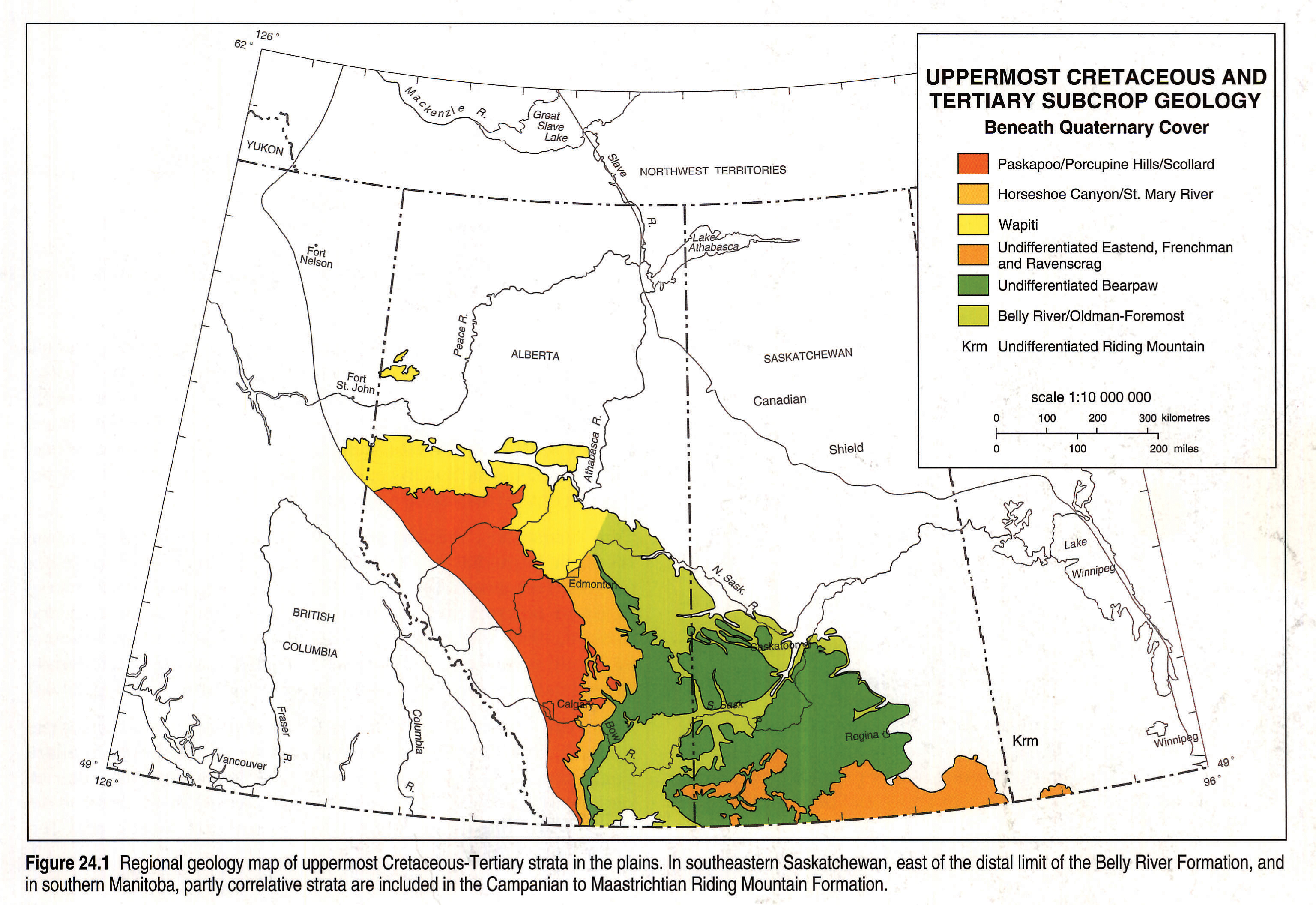
The top of the uppermost Cretaceous-Tertiary prism is a regional unconformity resulting from the removal of between one and three kilometres of sediment during post-Laramide erosion in the middle to late Tertiary (Nurkowski, 1984; Bustin, 1992). The bedrock geology beneath the Quaternary cover is illustrated in Figure 24.1.
The Cretaceous-Tertiary boundary can be traced throughout the basin (Sweet and Braman, 1992) and separates the upper and lower divisions of the Coalspur Formation in the foothills, the upper and lower divisions of the Scollard Formation in the Alberta Plains, and the Ravenscrag and Frenchman formations in Saskatchewan.
Stratigraphy
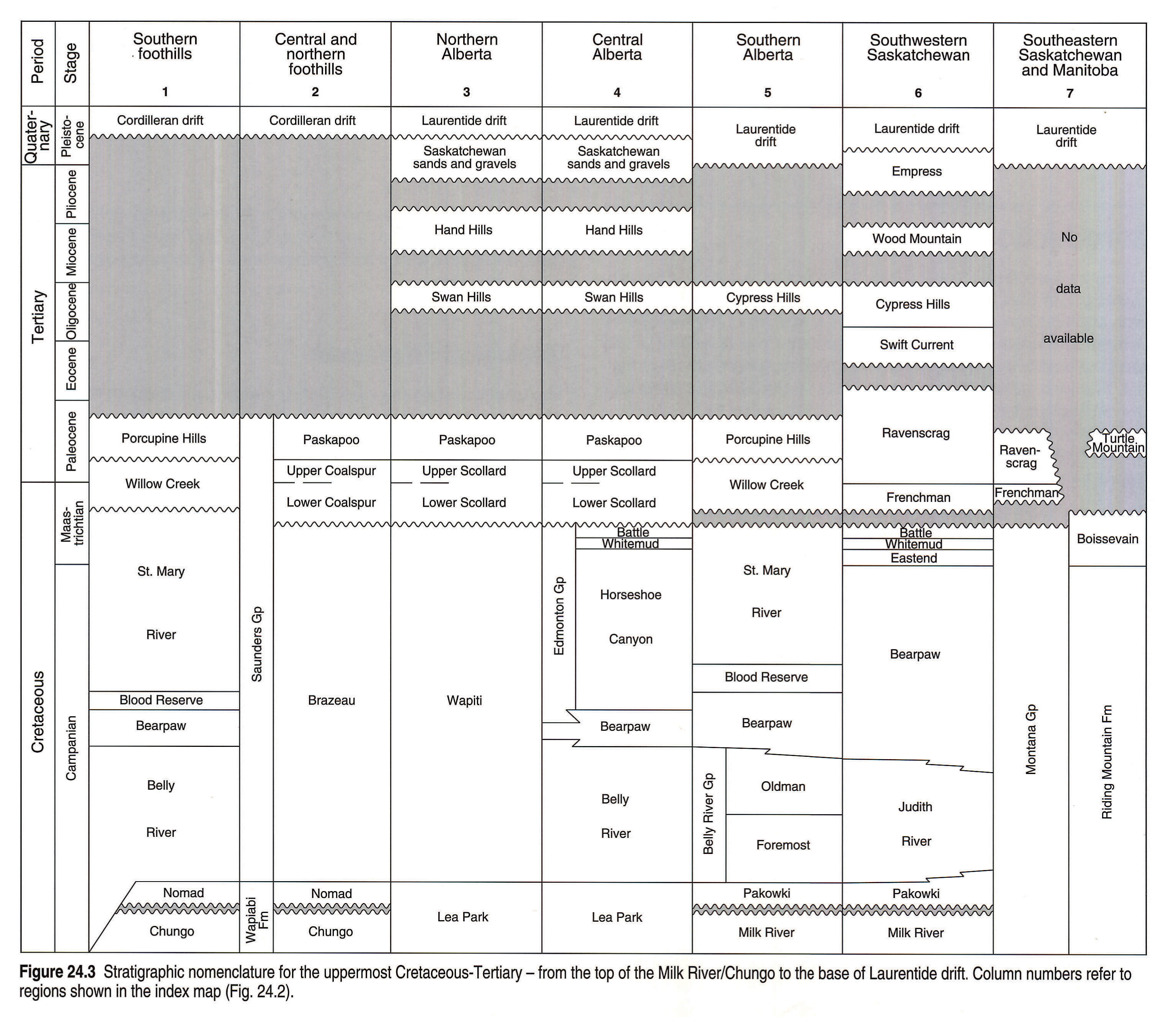
Stratigraphic Nomenclature
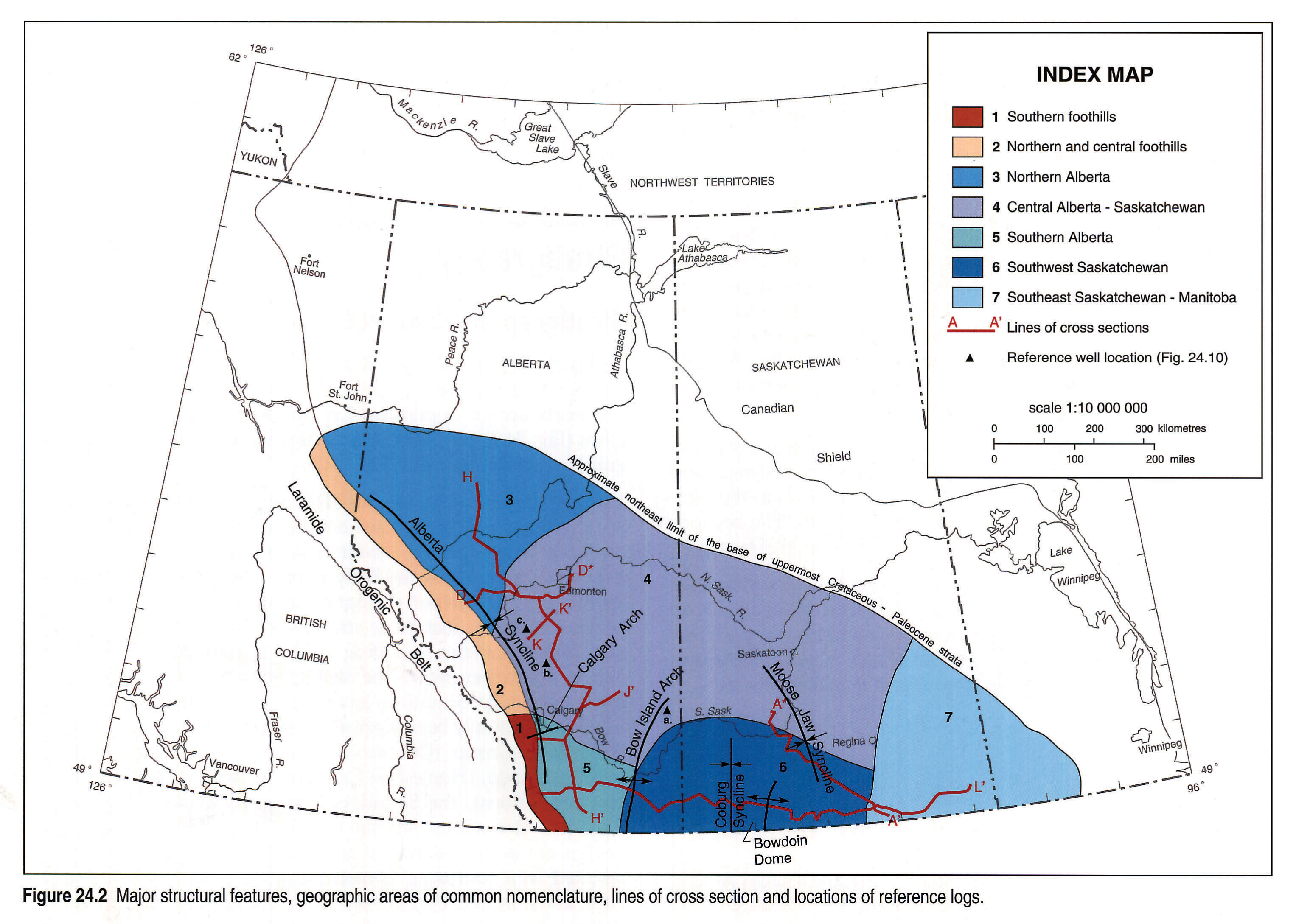
In this chapter, the Western Canada Sedimentary Basin is divided into seven geographic regions, each with a unique stratigraphic nomenclature for uppermost Cretaceous-Tertiary rocks. These regions (Fig. 24.2) correspond to those defined on the regional stratigraphic correlation chart (Fig. 24.3).
The original geological studies of the uppermost Cretaceous-Tertiary strata applied formational ranking to the facies associated with the three coarse-grained, diachronous sedimentary wedges, giving rise to names such as the Belly River, Edmonton, and Paskapoo formations. As further stratigraphic studies were completed, it became apparent that these strata were widely variable in thickness and lithofacies, resulting in the introduction of additional names to further refine the stratigraphic nomenclature. Where these secondary formations have been defined, the original formation has commonly been elevated to group status, thus creating the Belly River Group, (Oldman and Foremost formations), the Edmonton Group, (Horseshoe Canyon, Whitemud, Battle and Scollard formations), the Saunders Group, (Brazeau, Coalspur and Paskapoo formations) and the Wapiti Group. However, this process has not been undertaken universally across the basin, and has resulted in a confusing nomenclature. Further complicating the issue is the application of American stratigraphic terminology to define units in Canada, as exemplified by the introduction of the Judith River Formation (McLean, 1971) and Claggett Formation (Wasser, 1988).
Within the context of this chapter, the stratigraphic nomenclature as shown on Figure 24.3 is applied. For strata lying east of the Bow Island Arch, under the influence of the Williston Basin, the terminology introduced by McLean (1971) is utilized, whereas west of the Arch, stratigraphic nomenclature as originally applied to the foreland basin is used.
Where the Belly River Group is undifferentiated, the name Belly River Formation is used. The Horseshoe Canyon Formation name is used and the term Edmonton Group disregarded to allow compatibility between equivalent formations in Alberta and Saskatchewan. Work is in progress (Jerzykiewicz et al., 1992; Eberth and Hamblin, 1993) to redefine the stratigraphic interval currently called the Belly River Formation. These studies involve the upgrading of the Belly River Formation to Group status in the Alberta Plains and the introduction of formational names for the Belly River Group in southwestern Alberta. Foothills nomenclature is that of Jerzykiewicz (1985). In northwest Alberta, strata equivalent to the Belly River, Horseshoe Canyon, and where present the Whitemud and Battle formations are jointly defined as the Wapiti Formation rather than Wapiti Group (Dawson et al., 1992).
The "Belly River" wedge comprises the following formations: the Belly River in the central plains and the southern Alberta foothills, the lower half of the Brazeau in the central and northern Alberta foothills, the Oldman and underlying Foremost in the southern Alberta Plains, the lower half of the Wapiti in the northern Alberta Plains, and the Judith River in Saskatchewan (Koster, 1984). Those formations that make up the "Horseshoe Canyon wedge" are: the Horseshoe Canyon in the central plains, the St. Mary River and Blood Reserve in the southwestern plains and southern foothills, the upper half of the Brazeau in the central and northern foothills, the upper half of the Wapiti in the northwestern plains, the Eastend in Saskatchewan, and the Whitemud and Battle throughout the Alberta Plains and Saskatchewan. The "lower Scollard wedge" consists of the lower Scollard in the northern and central plains, the lower Willow Creek in southwestern Alberta, the Coalspur in the central and northern foothills, and the Frenchman in Saskatchewan. The "Paskapoo wedge" contains the Paskapoo Formation in the central and northern Alberta plains and foothills, the Porcupine Hills Formation in southwestern Alberta, and the upper Ravenscrag Formation in southern Saskatchewan.
Local names for specific stratigraphic intervals such as the "Highwood sand" or "Victoria sand member" are not used in the nomenclature for this chapter. The notable exception is the definition of the Scollard Formation and equivalents into upper and lower members. This division is defined by the basin-wide Cretaceous-Tertiary boundary.
In southern Saskatchewan the Eastend, Whitemud, Battle, Frenchman and Ravenscrag formations have been well defined from outcrop and shallow exploration boreholes. Limitations of the Atlas database did not allow these formations to be mapped on an individual basis and the entire stratigraphic interval above the Bearpaw Formation is undifferentiated.
Stratigraphic History
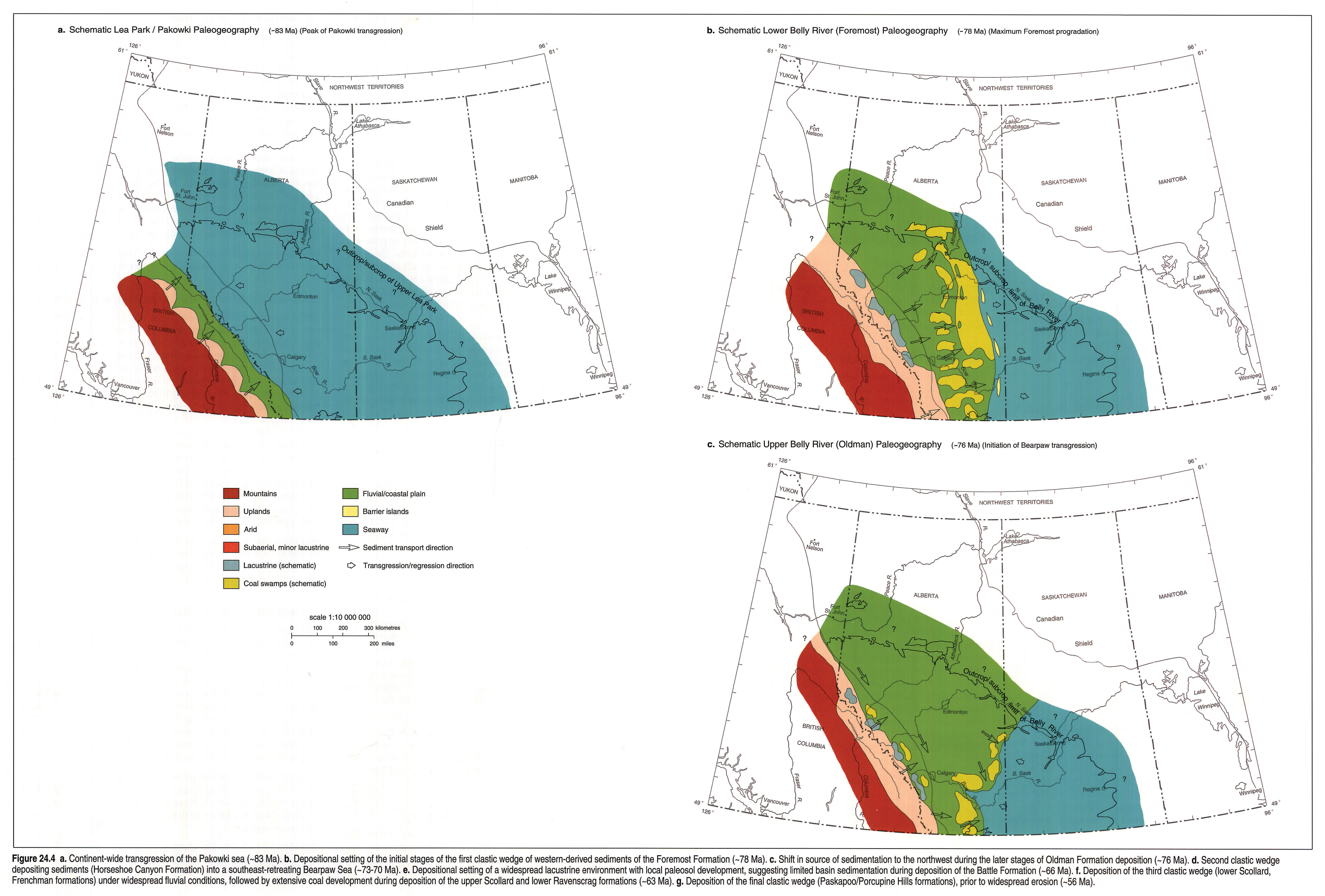
The lowest stratigraphic interval within the uppermost Cretaceous-Tertiary succession contains the Pakowki Formation, upper Lea Park Formation, and the Nomad Member of the Wapiabi Formation (Fig. 24.3). These rocks were deposited during a marine transgression in early Late Campanian time (Fig. 24.4a). The top of this succession is gradational into the coarser clastics of the Belly River wedge, which reflects the initial pulse of the Laramide Orogeny.
The lower portion of the Belly River wedge (Foremost Formation), was deposited in coastal to shallow-marine environments in southeastern Alberta (Fig. 24.4b). In southern Alberta, the predominantly fluvial sediments of the Oldman Formation overlie these strata (Fig. 24.4c). In south-central Saskatchewan the Belly River strata of the wedge (Judith River Formation; McLean, 1971), grade laterally into the Riding Mountain Formation.
During latest Campanian time, a second transgression occurred over Saskatchewan and southern and eastern Alberta, depositing fine-grained sediments of the Bearpaw Formation. The initial stages of the marine incursion appear to have been gradual in Saskatchewan and southeast Alberta. Widespread and rapid transgression followed throughout southern and central Alberta west of the Bow Island Arch (McLean 1971). The maximum limits of the transgression were to the northwest of Edmonton in the plains, and to the southwest into the foothills (Wall and Singh, 1975).
As the Bearpaw Sea retreated, coarse clastics were again deposited (Fig. 24.4d). This second pulse of continental detritus, the "Horseshoe Canyon wedge", prograded into the basin in an east-southeasterly direction from the northwest (Rahmani, 1981; Shepheard and Hills, 1970) and west (Nadon, 1988). It thins to the east where the Eastend Formation in Saskatchewan is equivalent to the upper portion of the Horseshoe Canyon Formation.
Two formations, the kaolinitic Whitemud and the fine-grained Battle, lie immediately above the coals at the top of the Horseshoe Canyon Formation. The Battle Formation, which is easily recognized in outcrop and in the subsurface (Elliot, 1960; Irish and Havard, 1968), was deposited in a relatively stable environment of lakes and poorly drained bogs in the east (Binda 1988), with widespread paleosol development in the west (Gibson, 1977; Fig. 24.4e).
Lying disconformably above the Battle Formation are the coarse-grained, continentally derived sediments of the lower Scollard Formation and its lateral equivalents. This stratigraphic interval represents the third, less prominent, wedge of clastic detritus derived from the emerging Rocky Mountains (Mack and Jerzykiewicz, 1989).
The coal-bearing upper Scollard Formation and equivalents lie conformably above the lower Scollard Formation. Extensive coal development occurs throughout the north-central and eastern portions of the basin (Fig. 24.4f). During upper Scollard deposition both the foreland basin and the Williston Basin were regionally stable and the sites of continental sedimentation. Marine conditions were restricted to the Cannonball Sea in southwestern Manitoba.
Following the widespread formation of coals, renewed tectonic activity in the middle Paleocene led to the extensive deposition of the Paskapoo Formation, the upper Ravenscrag Formation in Saskatchewan and the Porcupine Hills Formation in southwestern Alberta (Fig. 24.4g). Widespread uplift, erosion and deposition in Eocene to Miocene time resulted in the removal of up to 3000 m of strata (Nurkowski, 1984; Bustin, 1992). Remnants of the coarse-grained clastics of this stratigraphic interval are preserved in numerous topographic highs or valley fills in both Alberta and Saskatchewan (Russell, 1957).
Regional Cross Sections
Five stratigraphic cross sections illustrate the geometry and variability of the strata. The sections utilize the base of the Pakowki Formation as a datum. Where the Milk River Formation is not recognizable in the eastern areas, a distinctive geophysical log response (particularly on the resistivity and conductivity logs; the Milk River "shoulder") is used as the datum.
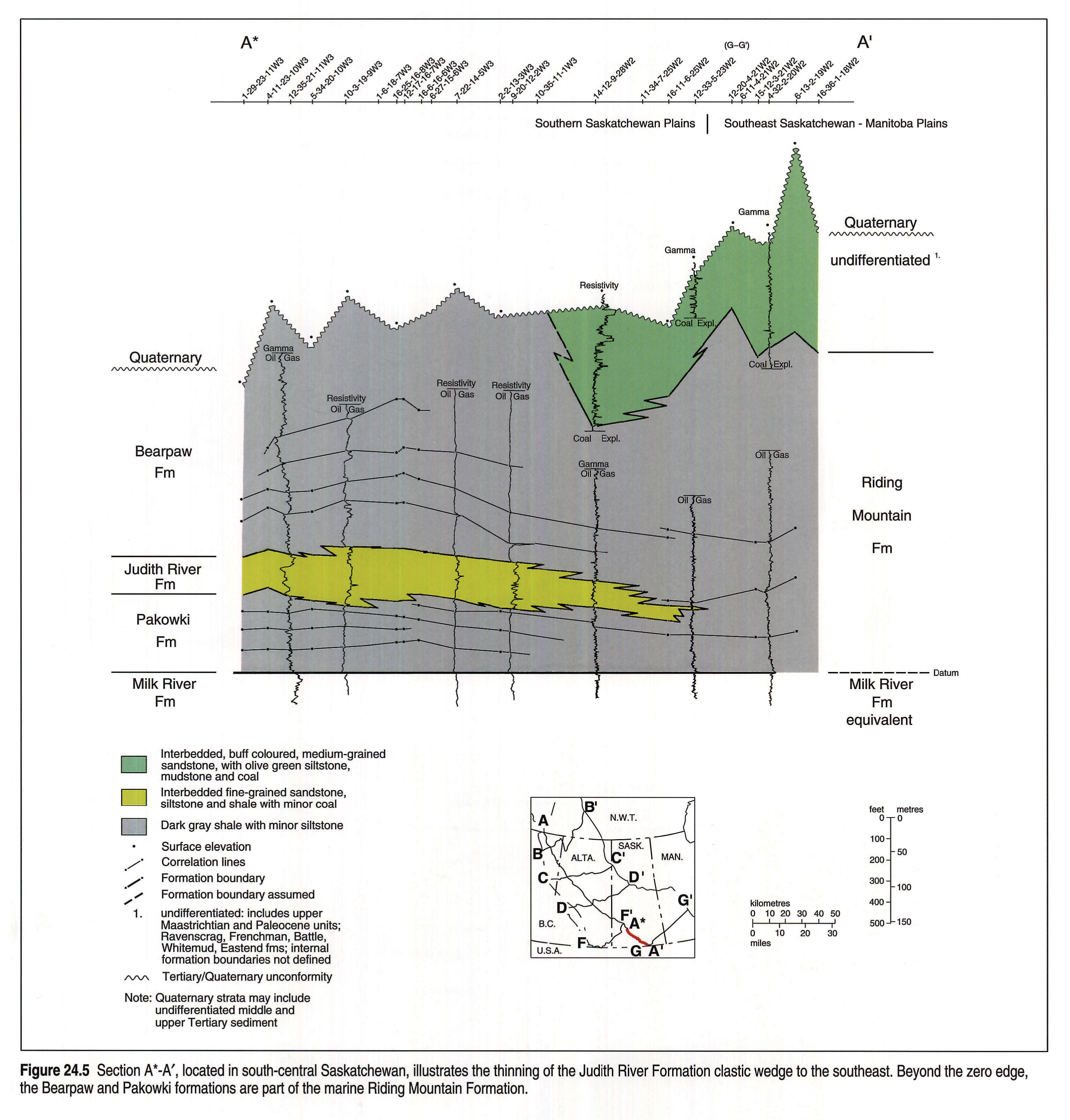
Section A*-A'
In this section (Fig. 24.5), the Judith River Formation pinches out in southern Saskatchewan and the underlying and overlying marine strata of the Pakowki and Bearpaw formations, respectively, merge to become the Riding Mountain Formation. The second and third wedge of non-marine strata of the Eastend, Whitemud, Battle, Frenchman and Ravenscrag formations overlie the Bearpaw/Riding Mountain formations except where removed by erosion.
In the southern half of this cross section, the Eastend, Whitemud, Battle, Frenchman and Ravenscrag formations are undifferentiated because the formations cannot be mapped individually. More information is available from the detailed coal and industrial mineral reports published by the Saskatchewan government and the Geological Survey of Canada, but most of these data are not integrated into the Atlas database (Irvine et al., 1978). The thin veneer of late Tertiary and Quaternary sediments is not displayed on the section.
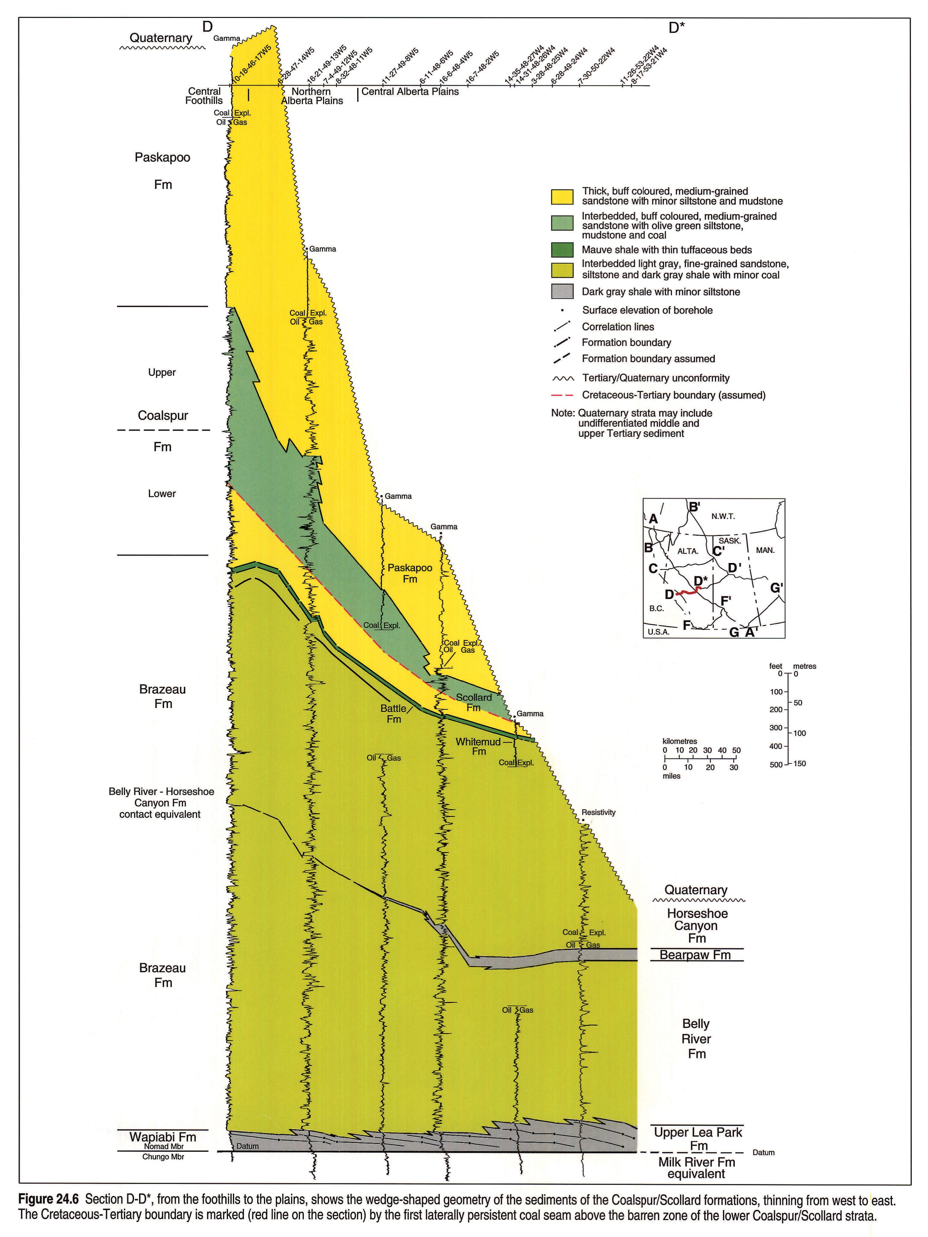
Section D-D*
Section D-D* (Fig. 24.6), in north-central Alberta, illustrates the easterly thinning of the clastic wedges and the predominance of coarse clastics. Westward thinning of the upper Lea Park and Bearpaw formations is evident in this area. Formations in the foothills, to the west of the cross section, are significantly thicker than the correlative horizons in the plains, primarily because of increased synsedimentary subsidence proximal to the emerging Rocky Mountains (Price, 1981).
Section L-L'
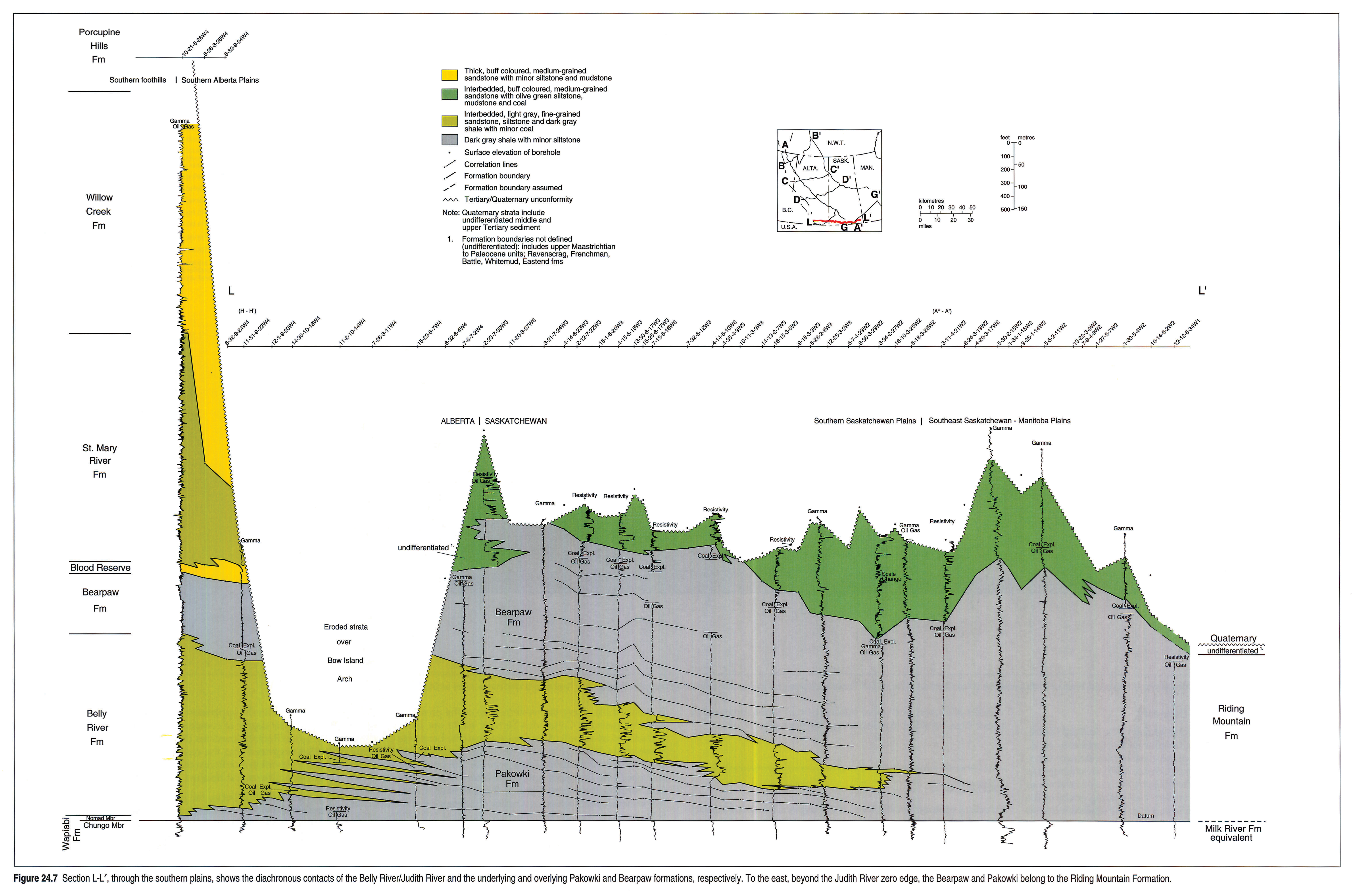
Cross section L-L' (Fig. 24.7) encompasses a west-to-east transect across the southern part of Alberta and Saskatchewan. This section best illustrates the eastward-thinning Belly River wedge, the Bearpaw transgression and the erosion over the Bow Island Arch. The Eastend, Battle, Whitemud, Frenchman and Ravenscrag formations are recognized in outcrop and coal exploration boreholes, but are not differentiated on Section L-L'. Although middle to upper Tertiary sediments are preserved on remnant highlands such as the Cypress Hills, and in old valley fills in southern Alberta and Saskatchewan, these strata are not included on the regional cross section.
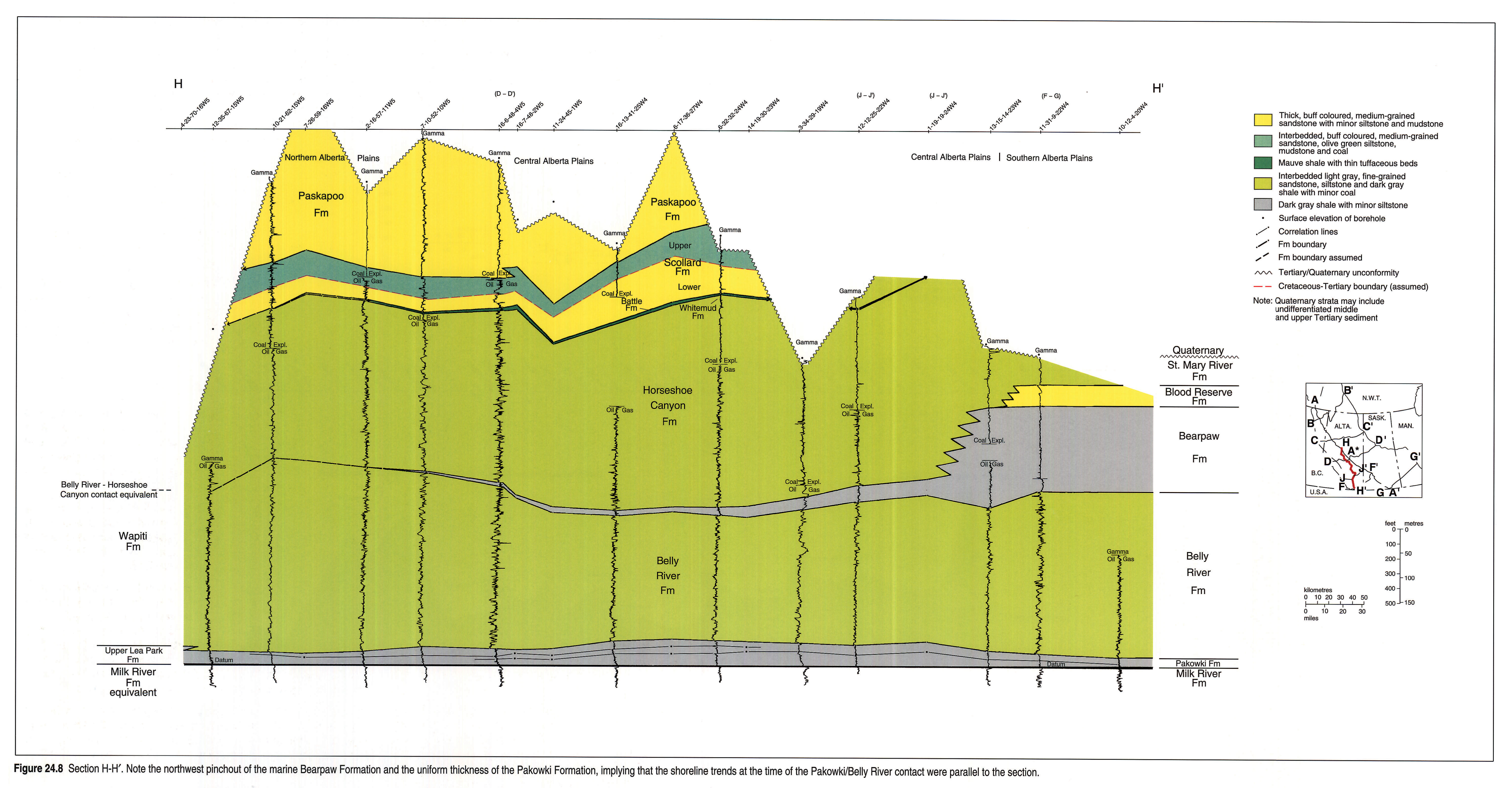
Section H-H'
This cross section (Fig. 24.8) is parallel to the Rocky Mountains, along the eastern flank of the Alberta Syncline. The northern limit is bounded by the subcrop of the Wapiti Formation, and the southern limit extends to the United States border. Because this section is parallel to the foreland basin axis, most of the formations appear to be of uniform thickness, the notable exception being the Bearpaw Formation, which thickens dramatically toward southwestern Alberta. Farther to the north, beyond the Bearpaw zero edge, the Wapiti Formation is equivalent to the Belly River, Horseshoe Canyon, Battle and Whitemud formations.
Above the Wapiti Formation and equivalents, strata of the Scollard and Paskapoo formations are widespread throughout the central portion of the province of Alberta.
Section J-J'
Cross section J-J' (Fig. 24.9) illustrates the eastward thinning of continental strata of the Belly River and St. Mary River formations. In the southwest corner of Alberta, the Blood Reserve Formation, a well developed shoreline sandstone, lies immediately above the Bearpaw Formation. The Bearpaw Formation increases in thickness to the northeast. This cross section also illustrates the great thickness of the western portion of uppermost Cretaceous-Tertiary strata, mostly because of the inclusion of the Willow Creek and Porcupine Hills formations.
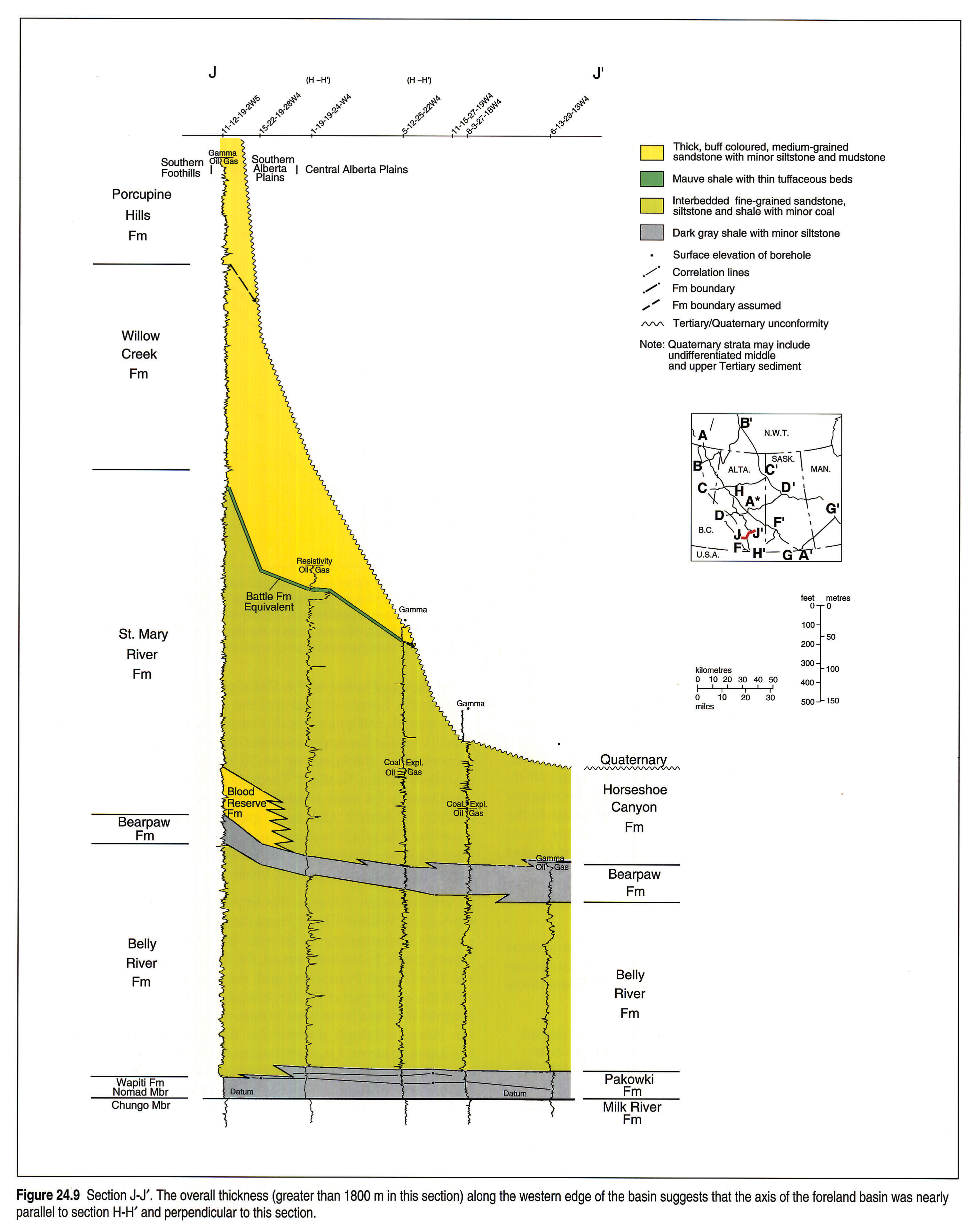
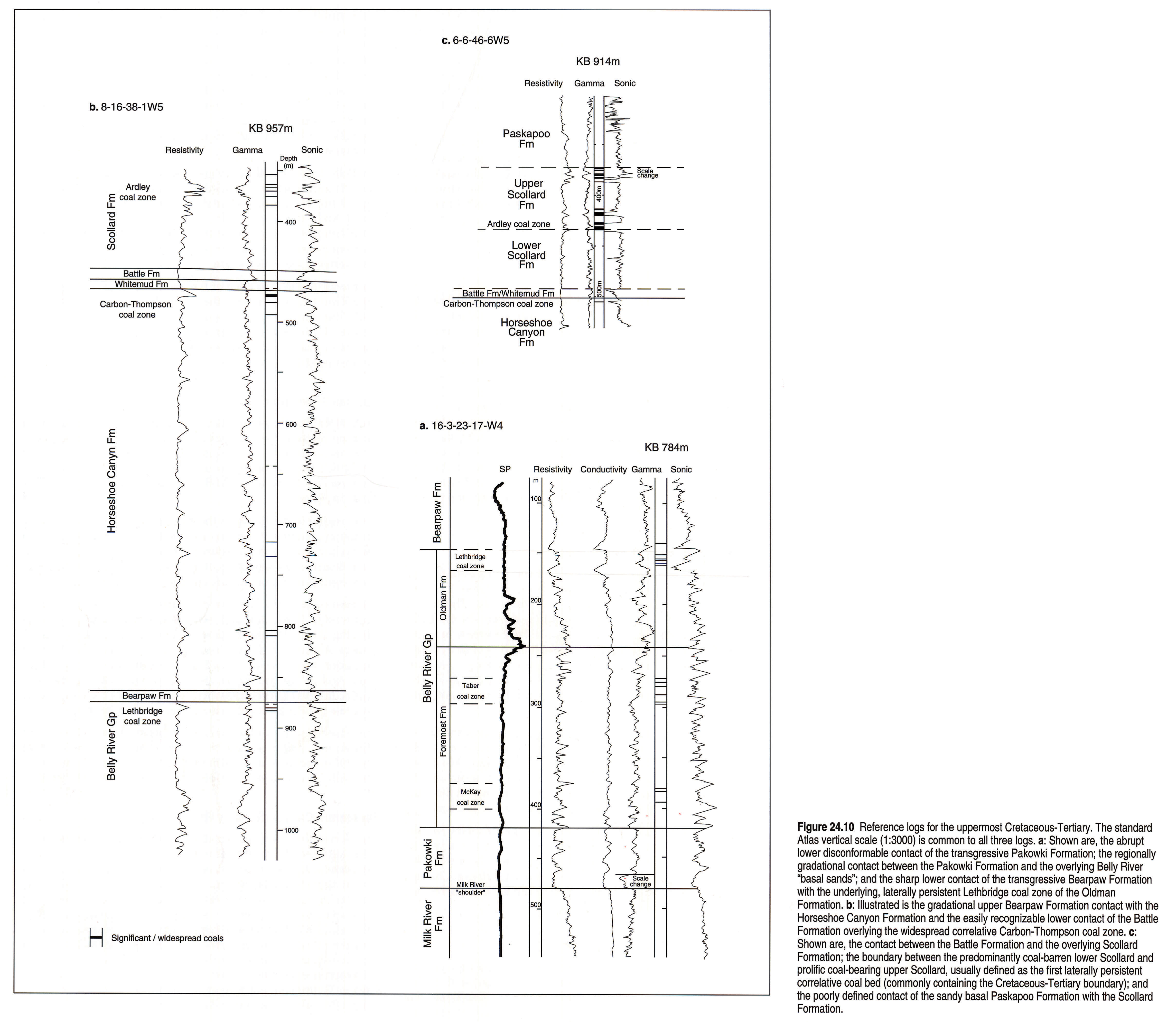
Reference Logs/Formation Boundaries
The widespread variability of facies and the overall thickness of the uppermost Cretaceous/Tertiary interval does not allow for depiction of a single reference log. Instead, typical geophysical logs (Fig. 24.10) and measured sections (Fig. 24.11) are presented that illustrate the salient features of formation boundaries as well as outcrop characteristics.
Pakowki/Milk River Formation Boundary
The base of the Pakowki Formation reflects a rapid marine transgression onto the coarser grained sediments of the Milk River Formation. In outcrop, the contact is abrupt and consists of mudstone and siltstone lying on sandy facies of the Milk River Formation. Beyond the depositional edge of the Milk River, to the north and east, fine-grained sediments of the upper Lea Park Formation (Pakowki equivalent) are indistinguishable from similar strata of the lower Lea Park Formation and a geophysical log marker is used to define the contact. This "Milk River shoulder" ("Eagle shoulder" in Saskatchewan) forms a distinctive resistivity and conductivity "kick" on the geophysical log and can be easily recognized in the subsurface (Fig. 24.10a).
Belly River/Pakowki Formation Boundary
The contact between marine strata of the Pakowki and continental sediments of the overlying Belly River Formation is diachronous and arbitrarily placed. The contact is defined (in this Atlas) as the base of the first coarsening-upward cycle capped by a major sandstone greater than 3 m thick (Fig. 24.10a). In the western and central regions of Alberta, this contact is recognized by the thick, relatively coarse-grained (low gamma-ray response) sandstones that lie immediately above the coarsening-upward cycle. In many parts of Alberta, the presence of a thin coal bed (McKay coal zone) capping the "basal Belly River sand" is used to assist in the recognition. In southern Alberta the contact is more gradational, with thin marine shales intertonguing with coarse clastics of the Belly River wedge (regional cross section L-L', Fig. 24.7). These interbedded successions are identified as the Foremost Formation. Sandstone beds up to 5 m thick tend to thin toward the east and eventually pinch out.
Basal Belly River Sandstone (B. Power)
The transitional contact between the marine Lea Park/Pakowki Formation and the overlying continental Belly River Formation consists of a series of coarsening-upward cycles, commonly incised by fluvial channels. This zone is usually defined as the "Basal Belly River Sand" and represents a significant hydrocarbon reservoir in Alberta. Section K-K' (Fig. 24.12), a cross section through the Pembina oil field, illustrates the variability of this basal sandstone unit. The cross section shows the presence of five distinct shoreface successions, stacked in a shingled pattern, prograding to the northeast. In the west, at the landward limit of the shoreface sediments, some of the marine strata are correlative with incised sediments of fluviodeltaic origin. The depositional setting of these cycles can be interpreted several ways. One possibility is that the transgressive/regressive cycles were caused by autocyclic depositional processes such as delta-lobe migration and abandonment, similar to the modern-day Mississippi delta.
Another postulation is that these transgressive/regressive cycles were caused by allocyclic processes resulting from small-scale fluctuations in relative sea level. The nature of the shoreline successions seems to support this interpretation. The shoreface successions of the Basal Belly River in the Pembina region are sharp based; sandstones of mid- to lower-shoreface environment sit abruptly on interbedded mudstones and siltstones deposited under marine shelf conditions. The contact is commonly angular and can contain rip-up clasts of the underlying sediments. The sharp base of the shoreface sediments is probably a result of a drop in relative sea-level. The decrease in water depth allowed waves and currents to erode the shelf immediately seaward of the shoreline, creating a marine erosion surface upon which the shoreface sediments were deposited.
Although the stratigraphic features of the Basal Belly River are similar to parasequence sets of a prograding shoreface succession, bounded by transgressive flooding surfaces at the top (Van Wagoner et al., 1990), on a detailed scale, each shoreface "shingle" is bounded at its base by an erosional unconformity caused by a drop in relative sea level, thus defining each shoreface "shingle" as a sequence. The Lea Park/Belly River transition may be better classified as a series of stacked, prograding, small-scale sequences.
The Lea Park/Belly River transition shown in Figure 24.12 is 75 m thick. Lerbekmo (1989) determined accumulation rates for the Campanian of Alberta to be approximately 60 m per million years. Based upon these rates, each transgressive-regressive cycle lasted approximately 250 000 years. The factors controlling high-frequency relative sea-level fluctuations are uncertain. However, regional tectonic processes such as subsidence due to thrust loading associated with the Laramide Orogeny may have contributed.
Bearpaw/Belly River Formation Boundary
The upper contact between the Belly River succession and overlying Bearpaw Formation is gradational in the eastern areas of Alberta and in western Saskatchewan, and more abrupt in the west. In the western and southwestern areas of Alberta, transgression of the Bearpaw Sea resulted in the deposition of fine-grained strata on coarse-grained sandstones of fluvial origin, reflected by a sharp lithological contact and geophysical log interface in the subsurface. In much of Alberta, the coals of the Lethbridge coal zone or equivalents, even though diachronous, represent a good stratigraphic marker, lying approximately 3 m below the top of the Belly River Formation. (Fig. 24.10b).
West and northwest of the zero edge of the Bearpaw Formation, the contact between the sediments of the Belly River wedge and the Horseshoe Canyon wedge is indistinguishable and the entire stratigraphic sequence is defined as the Wapiti Formation (or Brazeau Formation in the foothills).
Horseshoe Canyon/Bearpaw Formation Boundary
The transition from the predominantly marine strata of the Bearpaw Formation to continental strata of the Horseshoe Canyon Formation is easily recognized in outcrop throughout south-central Alberta and southern Saskatchewan. The dark gray-brown silty shales of the Bearpaw Formation contrast sharply with the light gray, kaolinitic, fine-grained sandstones of the overlying Horseshoe Canyon Formation. Commonly the boundary is relatively abrupt but in many places the contact is gradational, consisting of intertongueing fine- and coarse-grained sediments. Recognition of the boundary in the subsurface can be difficult because numerous coarsening-upward cycles of shale and siltstone to sandstone are present in close proximity to the Horseshoe Canyon/Bearpaw contact. In this chapter the boundary is arbitrarily defined as the base of the first coarsening-upward cycle capped by a major sandstone greater than 3 m in thickness, (Fig. 24.10b). In central Alberta, the lowest major sandstone of the Horseshoe Canyon Formation commonly is overlain by a thick coal, locally referred to as the Drumheller coal zone. The SP geophysical log is used in defining the formation boundary between the Eastend and Bearpaw in Saskatchewan where the silty nature of the sediments of both formations tends to hinder the use of the gamma-ray log.
In southwestern Alberta, the Bearpaw Formation is overlain gradationally by thick sandstones of the Blood Reserve Formation.
Battle-Whitemud/Horseshoe Canyon Formation Boundary
At the top of the Horseshoe Canyon Formation is a laterally persistent coal zone defined as the Carbon-Thompson coal zone. This interval contains up to 10 thin coal seams and is overlain by the Whitemud-Battle formations. The stratigraphic positions of these strata are distinct in outcrop and are mapped over much of southern Alberta and Saskatchewan (Irish and Havard, 1968). In the subsurface the Battle Formation is easily recognized by its distinctive low-resistivity log response, and by its proximity to the underlying Carbon-Thompson coal zone (Fig. 24.10b). Tuffaceous beds within the Battle Formation (sometimes referred to as the Kneehills Tuff zone) produce a high gamma-ray log response, which is often used as a stratigraphic marker in the subsurface (Lerbekmo, 1985). It must be noted, however, that there are similar tuffaceous beds within the overlying Scollard Formation and the recognition of the Horseshoe Canyon/Whitemud-Battle contact is dependent on the recognition of the entire sequence from the Horseshoe Canyon coals upward into the Battle Formation shales and tuffaceous beds.
In northwestern Alberta and closer to the foothills, the Battle Formation is not easily recognized because of regional facies variation and/or erosional downcutting of the overlying Scollard Formation (Baofang and Dawson, 1988).
Scollard/Battle Formation Boundary
The Scollard/Battle Formation boundary appears to be disconformable throughout much of the basin. In outcrop the distinctive mauve shales of the Battle are in sharp contrast to the buff to olive green sediments of the Scollard Formation. In the subsurface, the contact is difficult to place if the distinctive log response of the Battle Formation and the Carbon-Thompson coals are not recognizable. The contact is commonly abrupt, with thick sandstone units (up to 30 m) overlying the fine-grained strata of the Battle Formation. Locally these channel deposits downcut into the Battle Formation and rest disconformably on Whitemud or Horseshoe Canyon Formation strata (Baofang and Dawson, 1988).
In the foothills of northern Alberta, the basal coarse-grained unit of the lower Coalspur Formation is commonly conglomeratic, and is locally referred to as the Entrance Conglomerate (Jerzykiewicz and McLean, 1980). It is believed to be equivalent to the Scollard/Battle Formation contact.
In Saskatchewan, the Frenchman Formation (Scollard Formation equivalent) erosionally overlies older strata.
Paskapoo/Scollard Formation Boundary
The Paskapoo/Scollard boundary is similar to the Scollard/Battle, inasmuch as it is abrupt and disconformable (Lerbekmo et al., 1990). The contact is defined (at present) as the lowest major sandstone above the Ardley coal zone (Gibson, 1977). In outcrop this contact is normally marked by the thick, buff coloured sandstones of the Paskapoo lying directly on the coal-bearing strata of the Ardley coal zone (Demchuk and Hills, 1991). The sandstone bodies are commonly greater than 30 m thick. In the subsurface the Ardley coal zone is regionally correlatable and can be recognized throughout much of the basin except in the southwest, where climatic conditions hindered the development of peat swamps (Jerzykiewicz and Sweet, 1988). Correlative coals are recognized in the Coalspur and Ravenscrag formations. The Ardley coal zone consists of a lower and upper interval of coal seams separated by about 20 m, resulting in a distinct log response (Fig. 24.10c).
Structure
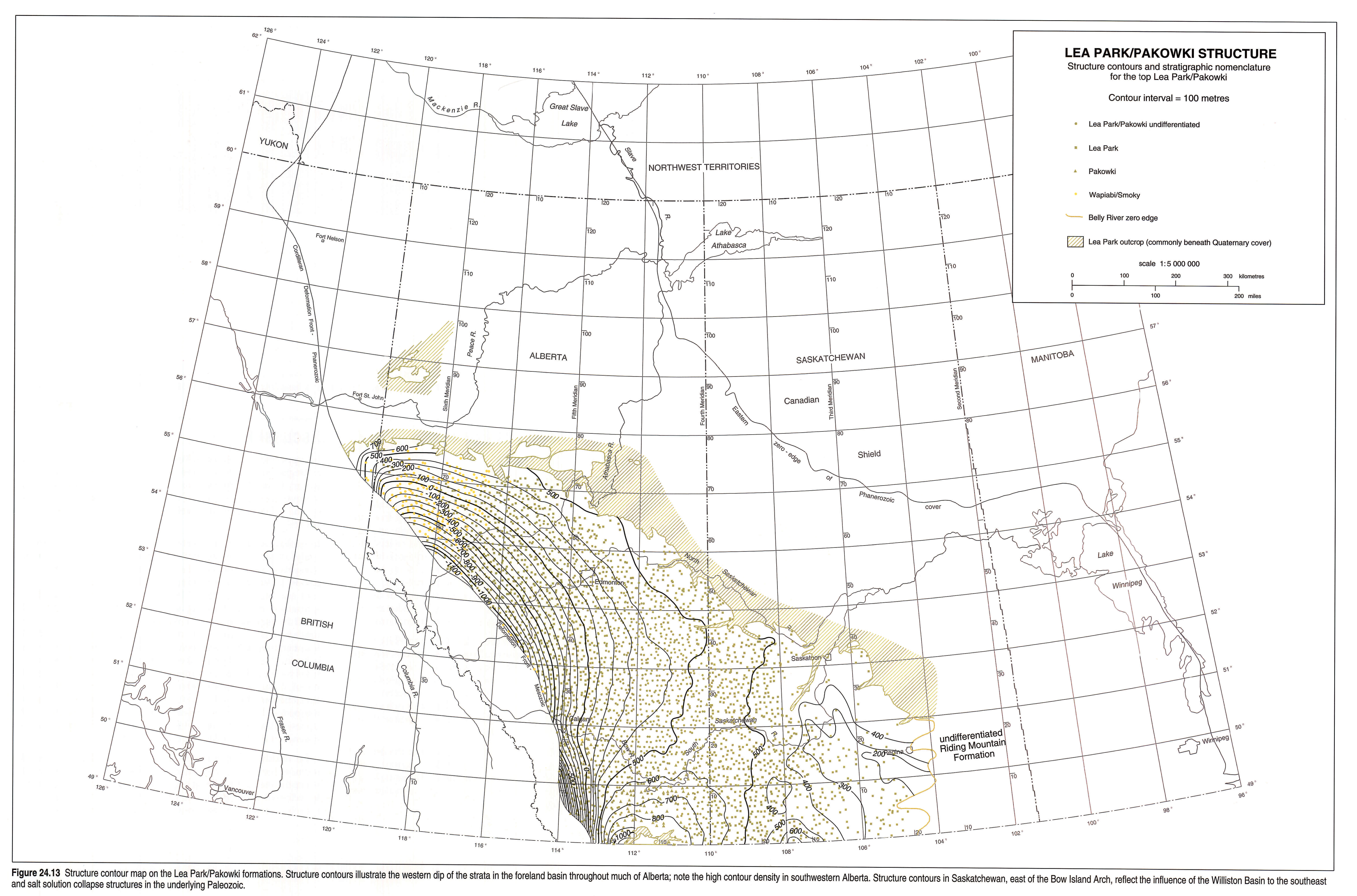
Structure contours on the base of the upper Cretaceous-Tertiary prism (base of the Pakowki Formation) illustrate two major basinal domains separated by the Bow Island Arch: the foreland basin in the west and the Williston Basin in southern Saskatchewan (Fig. 24.13). The main elements of the western limits of the Williston Basin are overprinted with local structures associated with salt collapse of underlying Paleozoic strata.
In the foothills, along the western edge of the preserved foreland basin, uppermost Cretaceous-Tertiary strata are faulted, folded and eroded as a result of the final stages of the Laramide Orogeny. These strata, although present in outcrop, are included in Figure 24.13 because of the limited data available. Immediately east of the disturbed belt, the uppermost Cretaceous-Tertiary rocks dip to the east, forming the western limb of the Alberta Syncline, a trough-like structure that formed as a result of depression of the foreland basin by overthrusting of the parallel-trending Rocky Mountains. East of the axis of the Alberta Syncline (Fig. 24.2), and west of the Bow Island Arch in southern Alberta, strata dip gently to the west. The structure contours indicate a higher degree of basinal downwarping in southwestern Alberta and a resulting thicker sedimentary section for the uppermost Cretaceous-Tertiary prism, suggesting a higher degree of compressional tectonism than other regions along the Rocky Mountains (Price, 1981). Jerzykiewicz and Sweet (1988) suggested that the compressional forces may have led to higher-elevation mountains that created a "rain shadow" effect for southern Alberta and resulted in a more arid environment.
In southeastern Alberta, the structural elevation of the strata is controlled by the Bow Island Arch, which separates the foreland basin from the Williston Basin. Strata on either side of the arch dip gently toward each basin. Present-day topographic surfaces have breached the arch, producing outcrops of strata as old as the Milk River Formation across the axis of this structure.
In southern Saskatchewan, the main structural element is the Williston Basin, and structure contours dip gently toward the centre of this basin in North Dakota. Salt dissolution within the underlying Paleozoic sediments has produced regional structural features such as the Bowdoin Dome and the Coburg and Moose Jaw synclines (Fig. 24.2), and local structural features such as folding and block faulting, which affected the depositional facies as well as the current structural elevations.
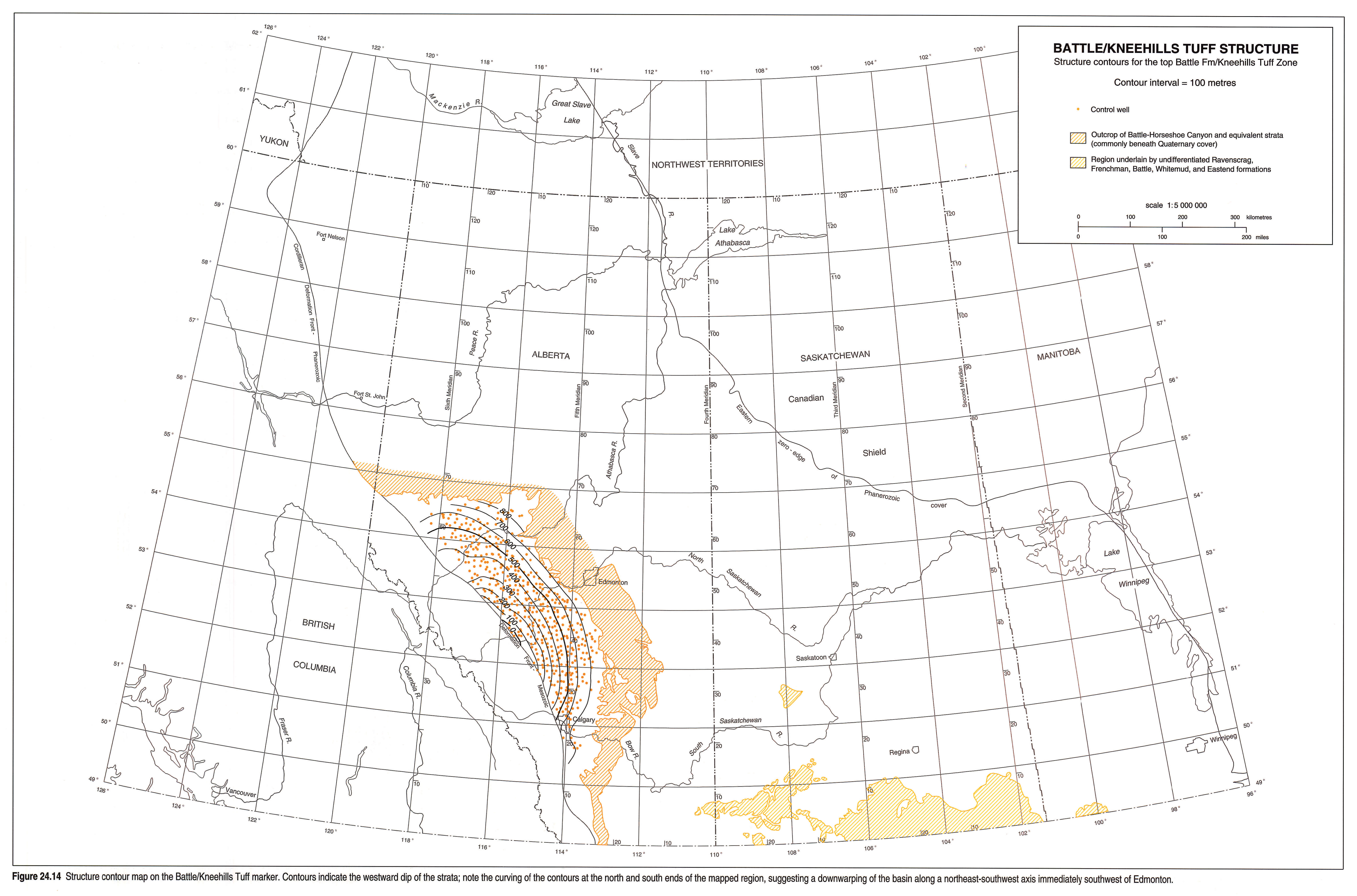
A structure contour map for the Battle Formation in central and southern Alberta (Fig. 24.14) indicates that strata approximately 1000 m above the Lea Park Formation dip gently to the west, in a manner similar to the underlying structure map. No structural data are available for the regions east of the Bow Island Arch.
Thickness and Lithology
The uppermost Cretaceous-Tertiary stratigraphic interval can be divided into seven distinct formations and their equivalents within the plains region of the Western Canada Sedimentary Basin: 1) Pakowki/upper Lea Park; 2) Belly River/Judith River; 3) Bearpaw; 4) Horseshoe Canyon/St. Mary River; 5) Whitemud-Battle; 6) Scollard/Frenchman; and 7) Paskapoo/Porcupine Hills. As a result of data limitations, only six isopach maps are illustrated: for the Pakowki, Belly River, Bearpaw, Horseshoe Canyon and Wapiti formations, and a map of the surface to Battle and surface to Bearpaw Formation combined. No maps are shown for the foothills equivalent strata because of structural complexity and insufficient data. For each isopach map, the region that lies between the top and bottom subcrop edge of each formation is hachured and is not contoured because the entire thickness of the formation is not present.
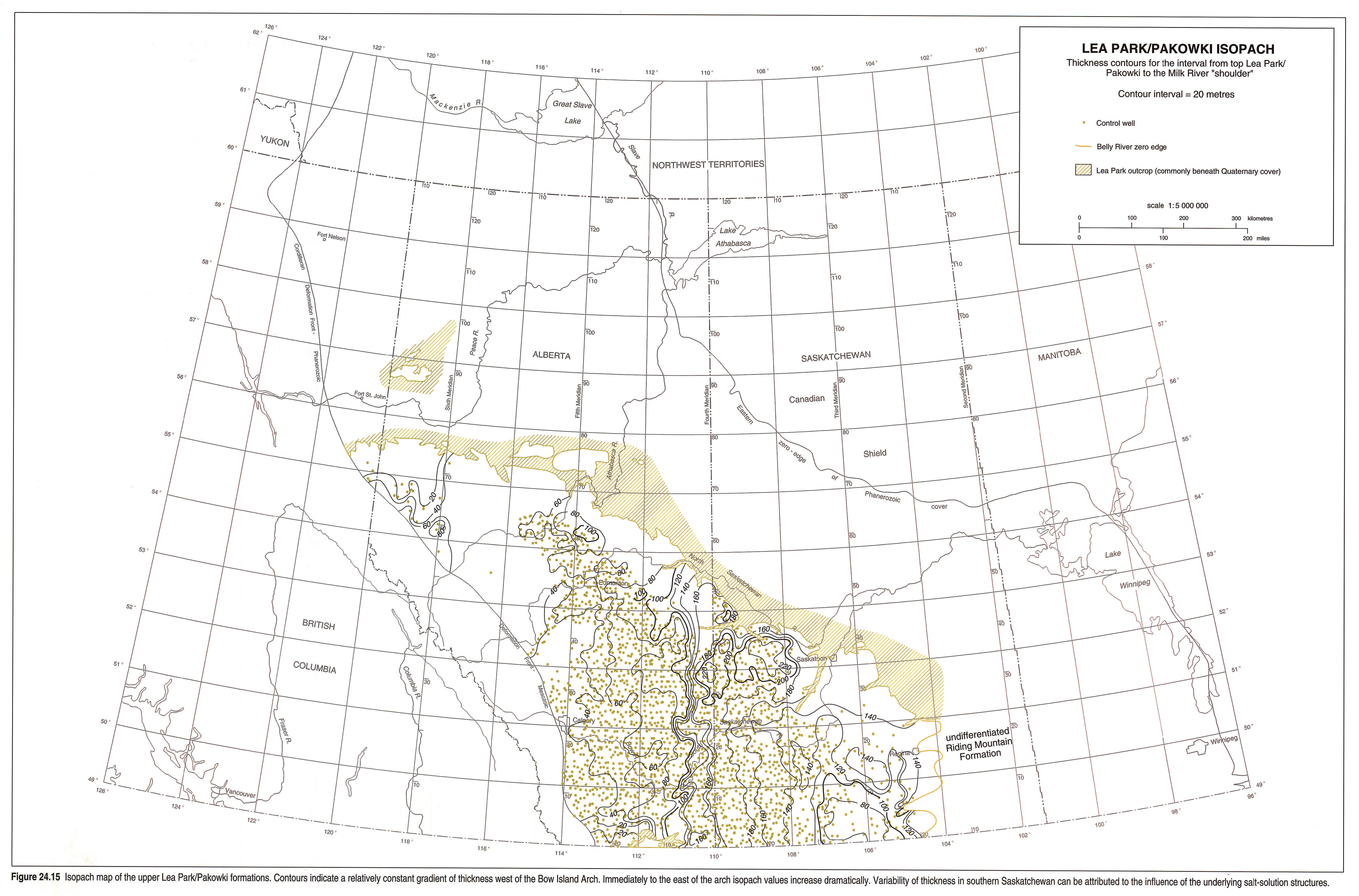
Pakowki/Upper Lea Park Formations
Sediments are predominantly fine grained, consisting of dark gray to brown mudstone and siltstone (Rosenthal et al., 1984). The base is abrupt and commonly marked by a pebble lag. The top is gradational with the overlying prograding clastics of the Belly River Formation (Fig 24.15). The marked easterly increase in thickness in eastern Alberta reflects an apparent stalling of Belly River progradation, with commensurate buildup of thicker Lea Park shales to the east, in western Saskatchewan (see also Fig. 24.7). The trend of the thickness increase is approximately coincident with the Bow Island Arch.
In south-central Saskatchewan, beyond the zero edge of the Judith River Formation, no isopach values are shown for the Pakowki/upper Lea Park because it merges with the Riding Mountain Formation (Caldwell et al., 1978). Salt dissolution structures in southern Saskatchewan appear to have had an impact on the local isopach variations of the Pakowki/upper Lea Park formations.
In the foothills, the equivalent Nomad Member (Wapiabi Formation) is less than 40 m thick and is assumed to pinch out farther to the west. In the southwest corner of Alberta, near Waterton National Park, the Nomad is absent and the underlying Chungo Member is undifferentiated from the overlying Belly River Formation (Lerbekmo, 1961; Lerand, 1980).
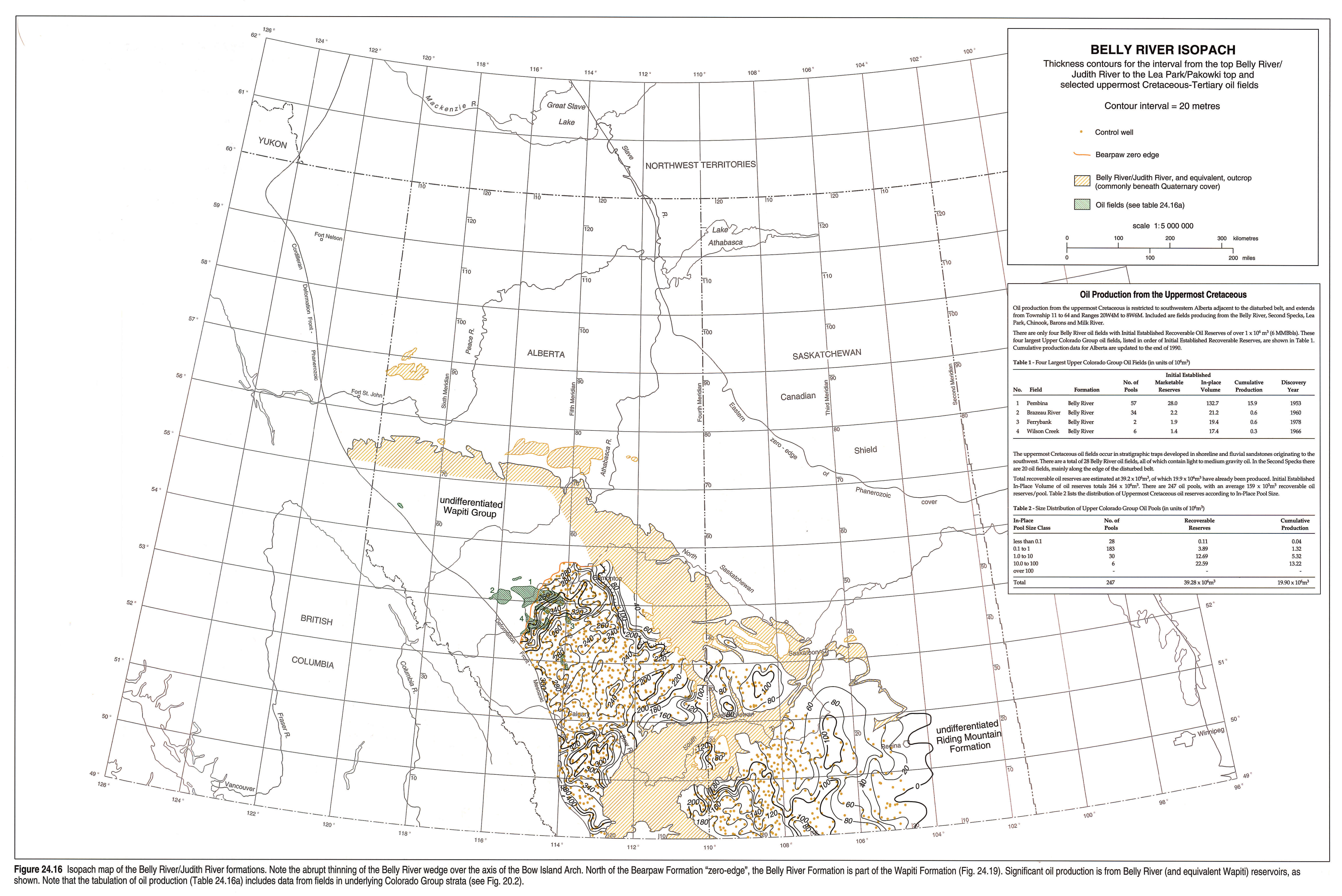
Belly River/Judith River Formations
Sediments are primarily of fluvial origin, consisting of light gray to buff, medium- to fine-grained sandstone and siltstone with minor mudstone and coal. Local fine-grained sediments, deposited in a lacustrine environment, are present along the western edge of the basin, parallel to the foothills (Jerzykiewicz, 1985). In southeastern Alberta, the lower portion of the Belly River (Foremost Formation), is fine grained and intertongues with marine sediments of the Pakowki. Sedimentological studies conducted by Lerbekmo (1963), Rahmani and Lerbekmo (1975), and Ogunyomi and Hills (1977) suggest that the source of sediment during early Belly River deposition (Foremost Formation) was from the southwest, in contrast to sediments deposited during middle and late Belly River deposition (Oldman Formation) which were derived from the northwest.
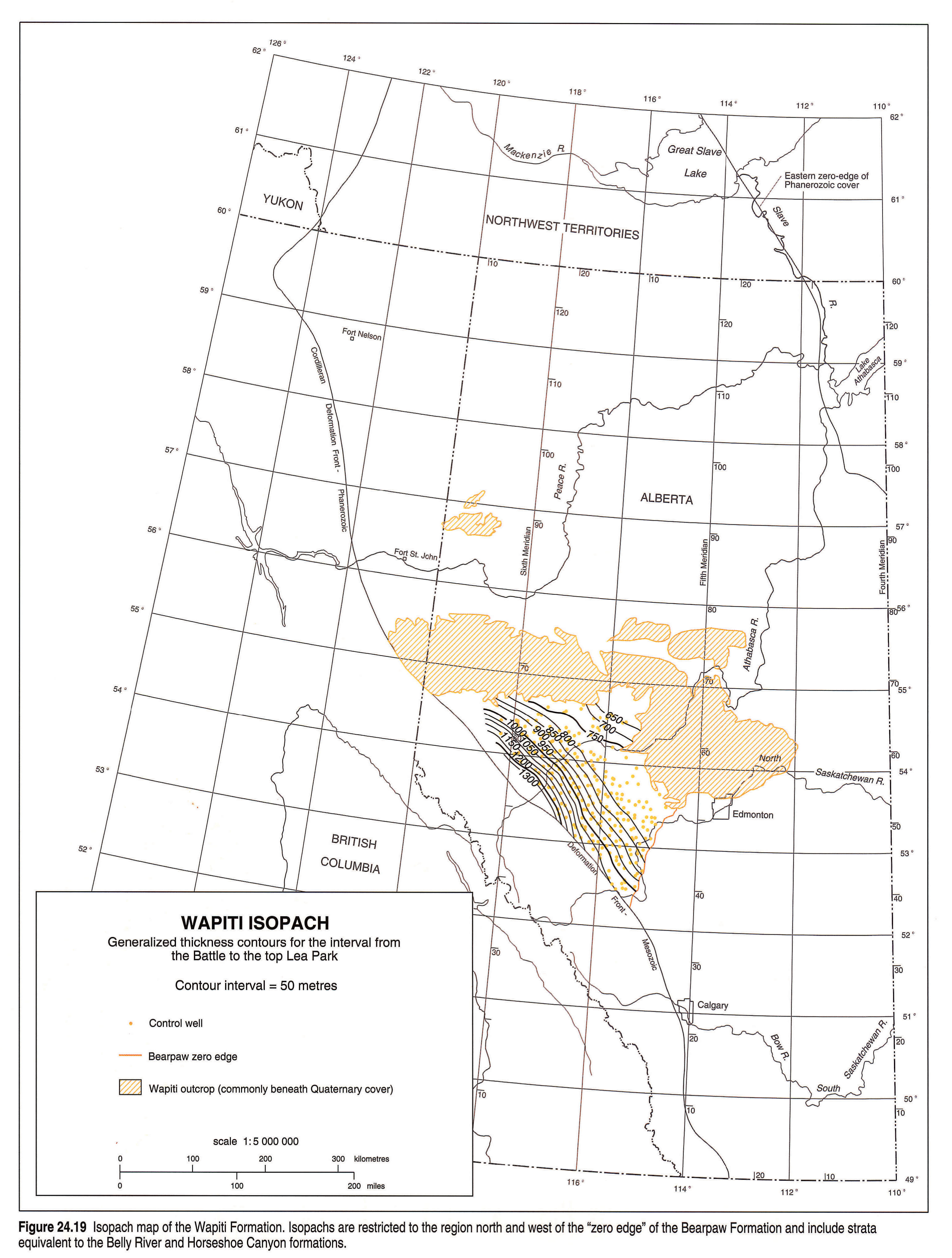
The Belly River/Judith River interval is greater than 700 m in the foothills and thins to a zero edge in south-central Saskatchewan (Fig. 24.16). The clastic wedge thins toward the region of the Bow Island Arch, thinning rapidly over the arch to less than 200 m immediately to the east of the structure. Local thickness variations in southern Saskatchewan are caused by salt dissolution structures in underlying Devonian strata. Northwest of the zero edge of the overlying Bearpaw Formation, Belly River strata are part of the Wapiti Formation (Dawson et al., 1992). The stratigraphic succession is in excess of 1500 m thick and consists of interbedded sandstone, siltstone, mudstone and minor coal, of fluvial origin. Isopachs for the Wapiti Formation interval are presented in Figure 24.19.
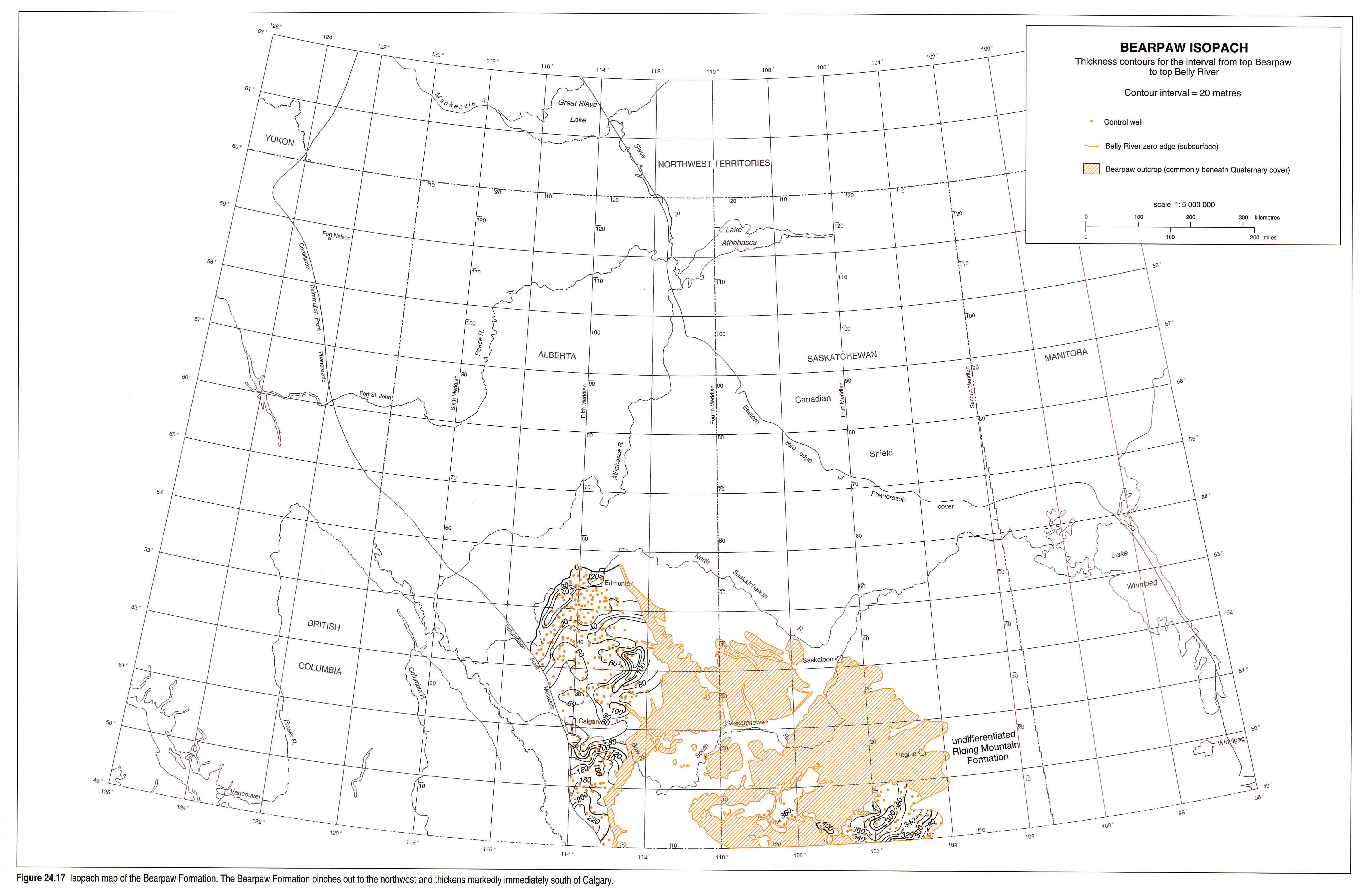
Bearpaw Formation
Strata of the Bearpaw Formation are primarily laminated shale and siltstone with some sandstone beds and lenses of kaolinitic claystone, deposited in an epeiric sea (Habib, 1981; Macdonald et al., 1987). Deposition took place in nearshore or marginal marine environments in the west and deeper, more open marine environments in the east.
In the region immediately to the east of the Bow Island Arch, the formation commonly contains interbedded sandstone and shale. The cyclic nature of these sediments may be related to the stalling of the Bearpaw transgression in front of subtle relief in the area of the present Bow Island Arch (Caldwell, 1968).
The zero edge of the Bearpaw Formation lies immediately to the northwest of Edmonton and extends southwest toward the foothills (Fig. 24.17). Paleontological evidence from outcrops in northeastern Alberta (Buffalo Head Hills), suggests that Bearpaw deposition may have continued to the north and east of the Peace River Arch (Wall and Singh, 1975). In central Alberta, the stratigraphic interval thickens toward the south and east, and attains a thickness greater than 400 m in southern Saskatchewan.
Immediately south of Calgary, the Bearpaw Formation thickens dramatically, and in southwest Alberta attains a thickness greater than 200 m, possibly as a result of increased downwarping associated with the emplacement of the Lewis Thrust (Nadon, 1988).
Horseshoe Canyon/St. Mary River Formations
The Horseshoe Canyon Formation consists of interbedded sandstone, siltstone and mudstone with up to ten potentially economic coal seams. Depositional environments ranged from marginal marine to fluvial and lacustrine. The lower half of the Horseshoe Canyon Formation was deposited in a predominantly paralic setting leading to widespread development of coal seams (Shepheard and Hills, 1970; Rahmani, 1988). Several local small-scale marine transgressive cycles such as the "Drumheller Marine Tongue" are present within this section of the formation. The upper half of the formation is essentially barren of coal, except for the widespread Carbon-Thompson coal zone at the top of the formation, reflecting mainly fluvial and lacustrine depositional environments.
The Horseshoe Canyon Formation (Fig. 24.18) forms an eastward-thinning wedge ranging from greater than 750 m in the western foothills to less than 30 m in southern Saskatchewan. No isopachs are shown for the Eastend Formation (uppermost Horseshoe Canyon equivalent) in Saskatchewan, because it is part of the undifferentiated post-Bearpaw interval (Figure 24.20).
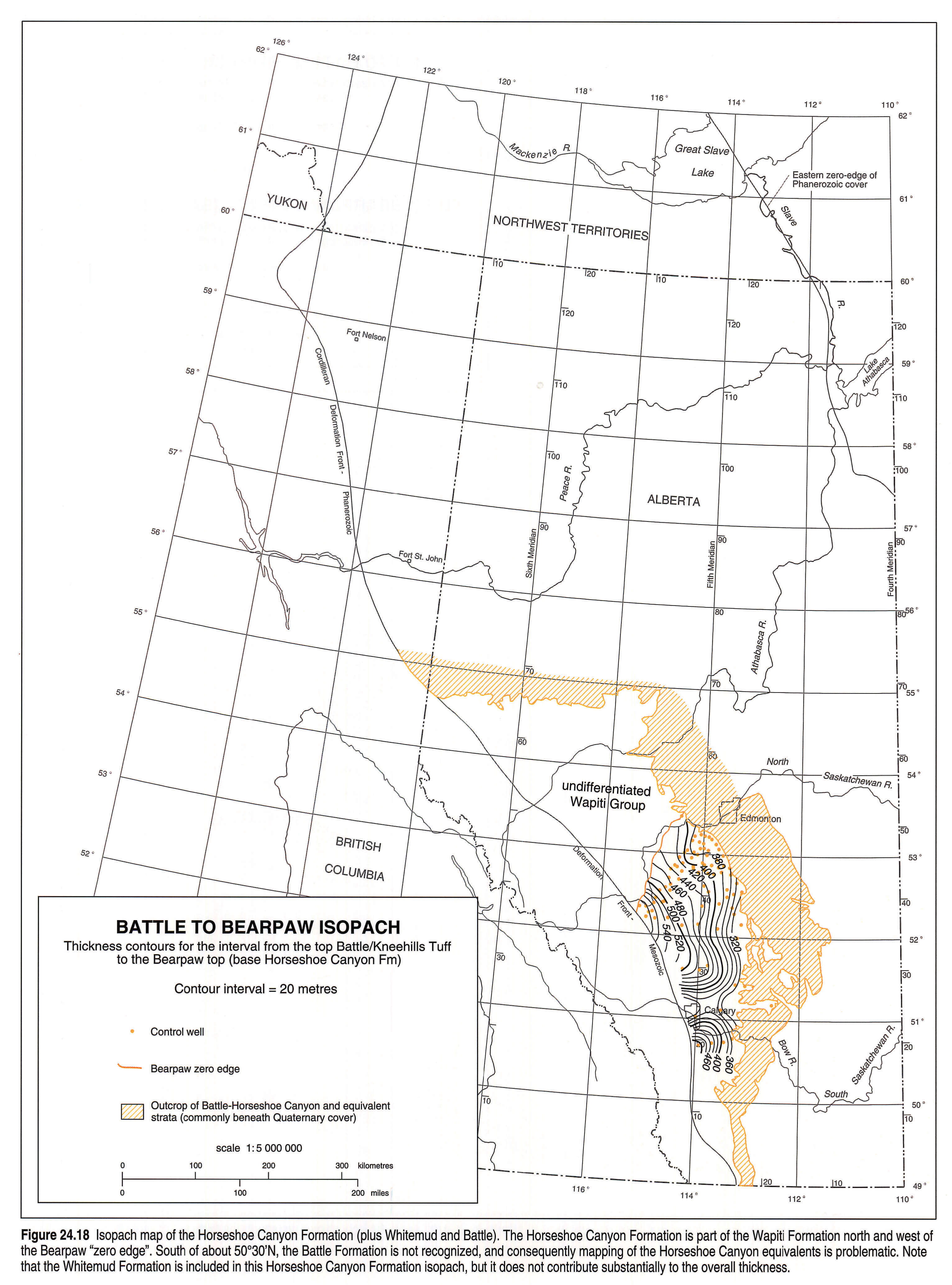
In the northwest, beyond the zero edge of the Bearpaw Formation, Horseshoe Canyon equivalent strata are part of the Wapiti Formation (Fig. 24.19).
In the southwest, the equivalent St. Mary River Formation was deposited in an area that appears to have been more proximal to the western mountains and in its rain shadow, resulting in a more arid environment (Jerzykiewicz and Sweet, 1988). At the base of this interval is the Blood Reserve Formation, a sandstone-dominated succession that represents a pronounced shoreline facies equivalent of the basal section of the Horseshoe Canyon Formation (see also Fig. 24.7).
Wapiti Formation
The Wapiti Formation in northwestern Alberta and northeastern British Columbia is equivalent to the entire Belly River to Battle succession in central Alberta (Dawson et al., 1992). In this region, the Bearpaw Formation is absent and the Whitemud and Battle strata are difficult to recognize both in outcrop and in the subsurface. Strata consist of interbedded sandstone and siltstone with minor mudstone and coal, all derived from a northwestern source (Rahmani and Lerbekmo, 1975). Depositional environments were mainly fluvial with local areas of lacustrine influence. The Wapiti Formation attains a thickness greater than 1300 m along the western edge of the foothills and thins toward the east (Fig. 24.19).
Whitemud-Battle Formations
The Whitemud-Battle formations represent a period of basin stability and limited sedimentation. The formations are laterally contiguous over much of Alberta and Saskatchewan and are easily recognized in outcrop by the white kaolinitic siltstone of the Whitemud, immediately overlain by the dark gray shales of the Battle. Both formations are fairly uniform in thickness, averaging 10 m. Several tuffaceous beds (e.g., Kneehills Tuff), which commonly weather to an orange clinker, lie within the Battle Formation. In the northwest, the Whitemud and Battle formations become more discontinuous and difficult to recognize in the subsurface, and equivalent strata are included in the Wapiti Formation.
Scollard Formation
The Scollard Formation consists of thick, gray to buff sandstone and siltstone units interbedded with thin, olive green mudstone beds and coal. Tuffaceous beds are locally present. Two members are recognized based on the abundance of coal. The lower member is generally barren of coal and the upper member contains thick, widespread, and economicallly important coal seams (Ardley coal zone). Coals in the upper member occur in up to 12 seams and have a cumulative thickness up to 20 m. Both the upper and lower members of the Scollard Formation thicken from east to west. Thicknesses for each member range from less than 100 m near outcrop in central Alberta to greater than 300 m in the Alberta Foothills. The foothills strata are referred to as the Coalspur Formation, the base of which is marked by the presence of the Entrance Conglomerate (Jerzykiewicz, 1985).
In southwestern Alberta, the upper and lower members of the equivalent Willow Creek Formation contain caliche deposits and redbeds characteristic of an arid environment (Jerzykiewicz and Sweet, 1988). In Saskatchewan, the lower member is equivalent to the Frenchman Formation and the upper member is correlative with the lower part of the Ravenscrag Formation. The stratigraphic interval thickens from west to east, toward the centre of the Williston Basin, although present-day topography also influences the thickness patterns. Local variations in Frenchman Formation thickness and distribution and the development of coal seams in the Ravenscrag Formation appear to be controlled by the syndepositional action of salt collapse structures in the Paleozoic.
Paskapoo Formation
The Paskapoo Formation consists of cycles of thick, tabular, buff coloured sandstone beds in excess of 15 m thick and commonly stacked into successions greater than 60 m thick, overlain by interbedded siltstone and mudstone. The formation is normally barren of coal, except for the Obed Marsh coal zone, about 700 m above the formation base. The Paskapoo thickens from east to west and exceeds 800 m in the foothills. Large volumes of clastic sediments were deposited in the basin following the widespread coal development of the upper Scollard, essentially burying the peat swamps and producing extensive deposits of coarse-grained sandstone lying disconformably on the underlying fine-grained sediments (Lerbekmo et al., 1990; Demchuk and Hills, 1991).
In southern Alberta, the equivalent Porcupine Hills Formation contains similar rock types and includes reworked caliche nodules from the underlying strata. In eastern Saskatchewan the correlative upper Ravenscrag Formation contains coals (Obed Marsh equivalent), currently being exploited by surface mining operations near Estevan. The top of the Paskapoo is unconformably overlain by poorly consolidated middle to upper Tertiary or Quaternary sediments.
Surface to Battle Formation Isopach Map
This isopach map (Fig. 24.20) was created to illustrate the thick series of clastic rocks that was deposited from mid-Maastrichtian to the present day. The formations included in this interval are the Scollard, Paskapoo and equivalents. A thin veneer of middle to upper Tertiary and Quaternary sediments is included within the isopach interval, but these do not contribute significantly to the overall thickness. The isopachs do not represent the original thickness of the Paskapoo Formation because much of it was removed during the Eocene to Pleistocene.
In Saskatchewan, the surface to Bearpaw Formation isopach is represented (Fig. 24.20). This interval encompasses the undifferentiated Eastend, Whitemud, Battle, Frenchman, and Ravenscrag formations, as well as the middle to upper Tertiary Saskatchewan Sands and Gravels (where present). The stratigraphic interval thickens to greater than 250 m toward the southeast, in the direction of the Williston Basin.
Cretaceous-Tertiary Boundary(A.R. Sweet)
Initial evidence of a physically identifiable universal datum at the Cretaceous-Tertiary (K-T) boundary was the recognition of a geochemical (iridium) anomaly at Gubbio, Italy coinciding with an extinction event (Alvarez et al., 1980). Subsequent studies have demonstrated the association of a worldwide boundary claystone containing anomalous elemental abundances along with shocked quartz, soot and microspherules, and carbon, oxygen and nitrogen isotope excursions, confirming a universal datum compatible with a paleontologically based K-T boundary (Alvarez, 1986). Together, the above features are interpreted as supportive of the hypothesis that one or more extraterrestrial bodies impacted the earth at the close of the Cretaceous (Alvarez, 1986), although some authors still favor an endogenic causal event (Officer, 1990).
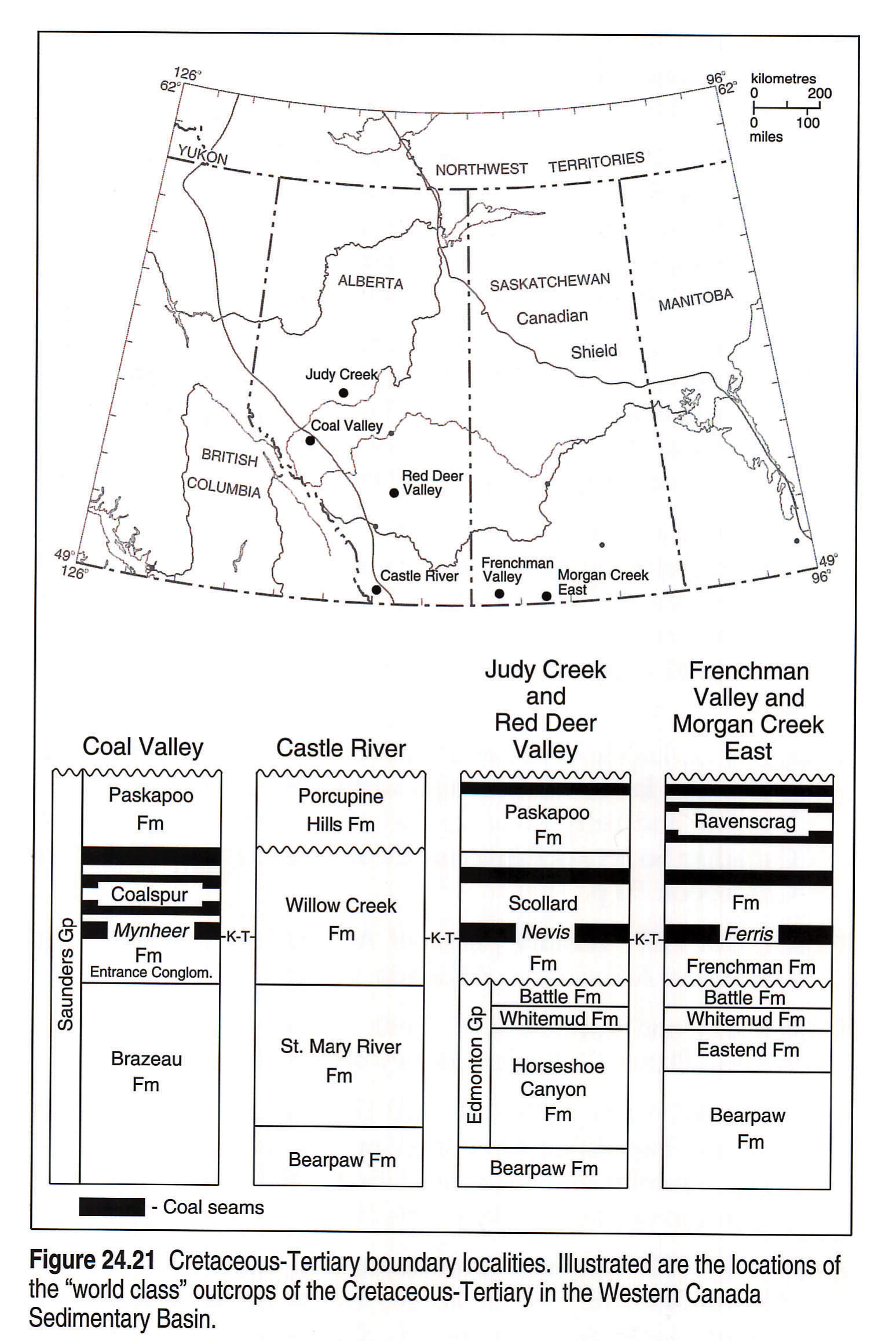
Regardless of the kind of causal event, this unique boundary horizon provides stratigraphers with an identifiable time line formed by an event postulated to be geologically instantaneous. This datum has been identified in 24 outcrop and subsurface sections in Western Canada, of which several world class sections (Fig. 24.21) have been used in sedimentological (Jerzykiewicz and Sweet, 1988), paleomagnetic (Lerbekmo and Coulter, 1985), geochemical (Lerbekmo and St. Louis, 1986), and palynological studies (Sweet and Braman, 1992; Lerbekmo et al., 1987). The identification of this boundary has allowed: 1) the correlation of strata between semiarid and humid facies associations south to north along the Alberta foothills; 2) the correlation of the boundary coal-horizon throughout Western Canada, including across the axis of the Alberta Syncline; and 3) the recognition of the diachronous initiation of coal deposition within the latest Maastrichtian, or coincidentally with the boundary event.
Geological History of Eocene to Pleistocene Deposits (W.A.D. Edwards)
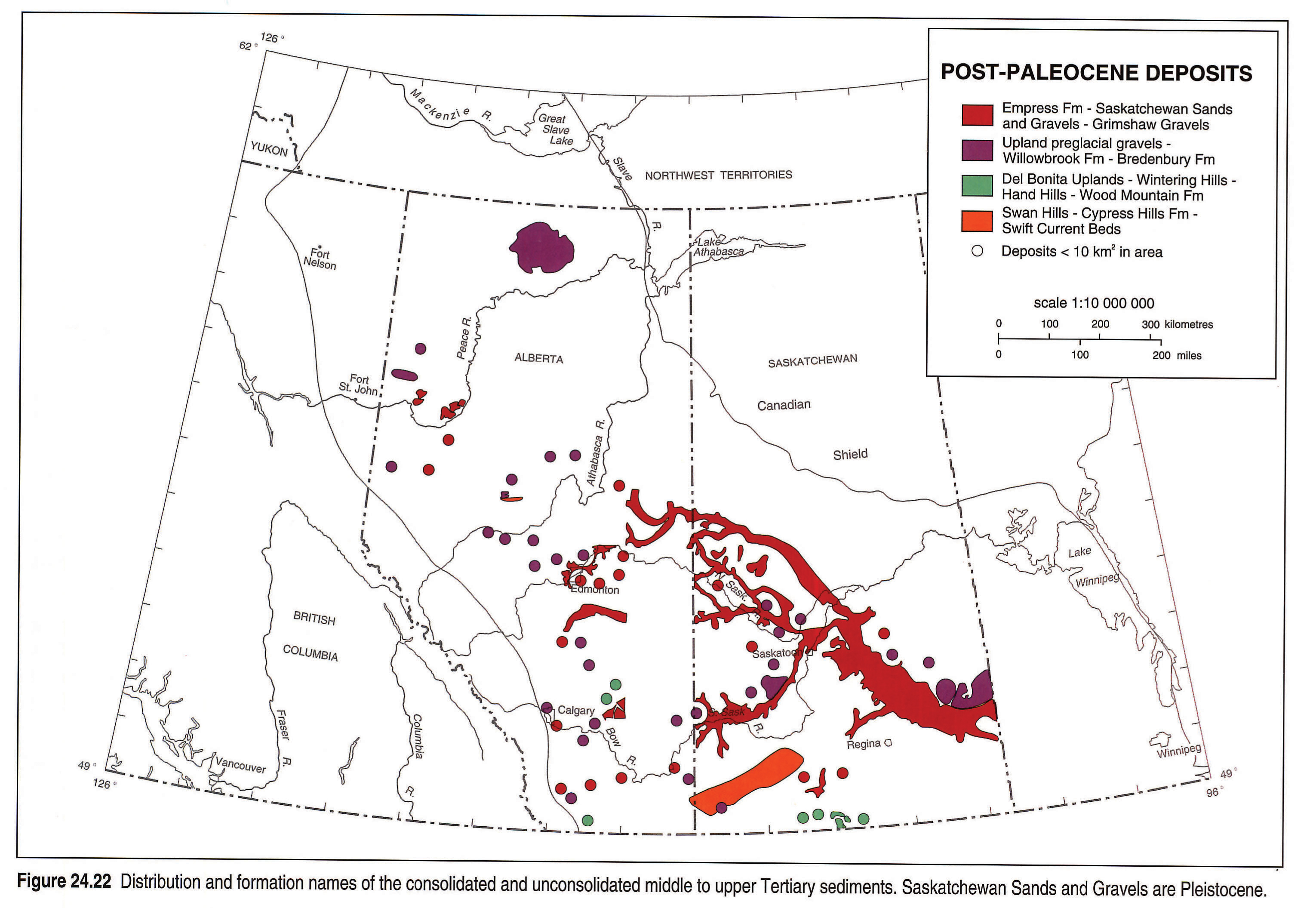
From the Eocene to Pleistocene, the Interior Plains were eroded by rivers flowing west-to-east and southwest-to-northeast from the newly formed Rocky Mountain Front Ranges. Paleocene and Upper Cretaceous strata were extensively removed and redeposited under fluvial conditions farther to the east. The earliest sediments are now represented by poorly indurated remnants on isolated uplands (Cypress Hills, Hand Hills and Swan Hills; Fig. 24.22; Leckie and Cheel, 1989). The youngest sediments occur as unconsolidated, incised valley-fill sands and gravels (Saskatchewan Sands and Gravels, Grimshaw Gravels, Empress Formation).
The elevation difference between the oldest (Cypress Hills, Swan Hills) and youngest (Saskatchewan, Grimshaw) gravels together with independent coal quality studies by Nurkowski (1984) and Bustin (1992) indicate that from one to three km of pre-Eocene sediments were eroded during the Tertiary to Pleistocene. Cross sections along three present-day rivers show the relative elevations of proximal preglacial deposits and the original surface (based upon Nurkowski 1984; Figs. 24.23a,b,c).
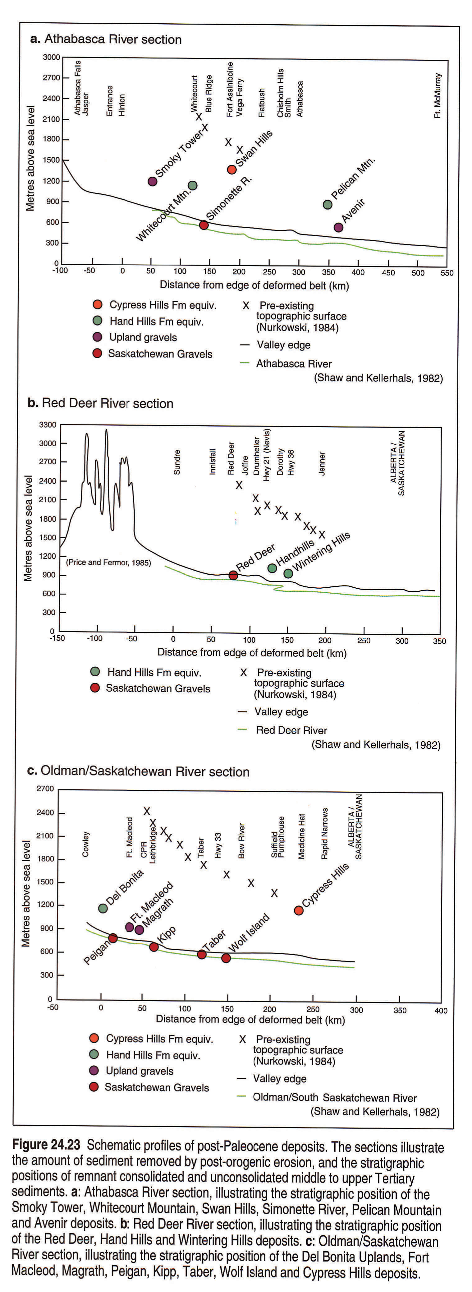
The youngest sediments were deposited just prior to the onset of Laurentide glaciation and are found at or below current plains level. As these deposits have not been subjected to the same length or degree of erosion, they are more continuous and complete than the older and higher deposits.
Discussion
The uppermost Cretaceous-Tertiary stratigraphic interval forms an integral part of the foreland basin of the Western Canada Sedimentary Basin. The formations that lie within this interval provide a unique geological record of the final development of the basin and the relation of that development to tectonics, eustasy and climate.
The geological history of this interval can be interpreted in terms of a series of tectonic events to the west, with resultant erosion and widespread sediment supply into the basin, interspersed with periods of limited sedimentation and/or marine transgression (Cant and Stockmal, 1989). The base of the stratigraphic slice is represented by the flooding surface associated with the widespread transgression of the Pakowki Sea. This period of marine inundation was short-lived in Alberta, as the emerging Rocky Mountains began to shed clastics from the west and southwest into the basin. This initial phase of continental sediment influx is represented by the Belly River Formation and its equivalents. Progradation of these sediments extended as far east as south-central Saskatchewan, beyond which marine sedimentation continued unimpeded. Local facies variations occur in the region around the Cypress Hills of southern Alberta, possibly responding to the influence of the Bow Island Arch.
In the middle Campanian, (~78 Ma), during deposition of the Foremost Formation, the source of sediment was principally from the southwest. Later, during deposition of the Oldman Formation, the sediment source shifted to the northwest, probably as a result of reactivation of mountain building in the northern regions.
Following the deposition of the Belly River wedge, a widespread marine incursion from the southeast occurred, giving rise to the sediments of the Bearpaw Formation (~76 Ma). The Bearpaw Sea extended from southeast Saskatchewan to north of Edmonton. Farther to the north, beyond the limit of marine deposition, continental sedimentation continued unimpeded.
The second major sedimentary wedge (Horseshoe Canyon Formation) prograded into a gradually retreating Bearpaw Sea during early Maastrichtian time (~73-70 Ma). The source of sediments was principally from the northwest and west. Depositional environments of the aggrading section varied from shallow marine and deltaic near the base to fluvial near the top. The upper strata of the Horseshoe Canyon Formation include a widespread coal zone (Carbon-Thompson), which is overlain by a distinctive, whitish, kaolinitic siltstone (Whitemud Formation) and dark gray mudstone (Battle Formation). It is probable that at this time (~66 Ma), the foreland basin was essentially filled, and that isostatic rebound of the basin may have been responsible for the regional disconformity at the top or within the Battle Formation.
During the late Maastrichtian (~66-64 Ma), renewed tectonic activity and downwarping of the western half of the foreland basin led to the deposition of a third clastic wedge. The lower Scollard and its equivalents are essentially barren of coal and extend throughout most of the basin. Paleoflow measurements (Jerzykiewicz and Labonte, 1991) indicate a mainly northeasterly flow direction in the foothills.
At the time of the Cretaceous-Tertiary boundary (~63.4 Ma), sediment input into the basin decreased substantially, giving rise to a stable alluvial plain environment and subsequent coal development. Tectonic quiescence or differing erosion patterns in the mountains to the west may explain the decreased supply of detritus into the basin. Paleoflow directions during this time appear to have been parallel to the mountain front, indicating a general paleoslope to the southeast. In southwestern Alberta, higher sedimentation rates continued, giving rise to thick successions of the Willow Creek Formation. Widespread caliche horizons are present rather than coals, as a result of an arid climate for this region. The arid climate, coupled with the higher sedimentation rates, suggests that the mountains to the west in southern British Columbia produced an intense rain shadow effect, similar to what we see today.
Following the relatively stable regime of coal development during deposition of the upper Scollard Formation and its equivalents, renewed high-energy sedimentation into the basin resulted in the deposition of the clastics of the Paskapoo Formation (~63-58 Ma). As with the lower Scollard, sediments in the Paskapoo Formation indicate paleflow directions in an east-northeast direction in the foothills (Jerzykiewicz and Labonte, 1991).
The final event of Late Cretaceous-Tertiary sedimentation involved the uplift and erosion of greater than 1000 m of post-Paleocene sediments from the basin. Regional tectonic uplift and isostatic rebound have been postulated as the cause for the removal of this thick sedimentary sequence during Eocene to Pliocene time (~56-2 Ma).
Acknowledgements
The authors would like to acknowledge the contributions of the following, who were involved either in the initial organization of this chapter or who offered technical expertise or information: A.R. Sweet, Geological Survey of Canada; T. Jerzykiewicz, Geological Survey of Canada; W.J. McDougall, W.J. McDougall Consulting Ltd.; G. Diakiw, Consultant, Calgary; J. Battacharya, Alberta Research Council; E. Koster, Royal Tyrrell Museum, Drumheller; G.G. Smith, Geological Survey of Canada; A.P. Hamblin, Geological Survey of Canada; C. Boonstra, Geological Survey of Canada.
In addition, it should be noted that the Alberta Research Council (Coal Geology Section) and the Geological Survey of Canada provided much of the data upon which the subsurface information is based.
The authors would like to express appreciation to A.R. Sweet and A.P. Hamblin of the Geological Survey of Canada, J. Lerbekmo of the University of Alberta, and D. Eberth of the Royal Tyrrell Museum in Drumheller for their technical reviews of this chapter.
References
- Allan, J.A. and Rutherford, R.L. 1934. Geology of central Alberta. Research Council of Alberta, Geology Division, Report 30, 41, V. p.
- Alverez, L.W., Alvarez, W., Asaro, F., and Michel, H.V. 1980. Extraterrestrial cause for the Cretaceous-Tertiary extinction. Science, v. 208, p. 1095-1108.
- Alvarez, W. 1986. Towards a theory of impact crisis. Eos, v. 67, p. 649, 653-655, 658.
- Baofang, L. and Dawson, F.M. 1988. Stratigraphic framework and depositional setting, Judy Creek coalfield, northern Alberta. In: Current Research, Part D, Geological Survey of Canada, Paper 88-1D, p. 121-128.
- Binda, P.L. 1988. The Battle Formation: A lacustrine episode in the late Maastrichtian of Western Canada. In: Aspects of Nonmarine Cretaceous Geology. N.J. Matter and P.J. Chin, (eds.). China Ocean Press.
- Bustin, R.M. 1992. Organic maturation of the Western Canadian Sedimentary Basin. International Journal of Coal Geology, v. 19, p. 319-358.
- Caldwell. W.G.E. 1968. The Late Cretaceous Bearpaw Formation in the South Saskatchewan River Valley. Saskatchewan Research Council, Geology Division, Report 8, 86 p.
- Caldwell, W.G.E., North, B.R., Stelck, C.R., and Wall, J.H. 1978. A foraminiferal zonal scheme for the Cretaceous System in the interior plains of Canada. In: Western and Arctic Canadian Biostratigraphy. C.R. Stelck and B.D.E. Chatterton (eds.). Geological Association of Canada, Special Paper 18, p. 495-575.
- Cant, D.J. and Stockmal, G.S. 1989. The Alberta foreland basin: relationship between stratigraphy and Cordilleran terrane-accretion events. Canadian Journal of Earth Science, no. 26, p. 1964-1975.
- Carrigy, M.A. 1970. Proposed revision of the boundaries of the Paskapoo Formation in the Alberta Plains. Bulletin of Canadian Petroleum Geology, v. 18, p. 156-165.
- Crockford, M.B.B. 1949. Oldman and Foremost formations of southern Alberta. American Association of Petroleum Geologists, Bulletin, v. 33, p. 500-510.
- Dawson, F.M., Kalkreuth, W.D., and Sweet, A.R. 1992. Stratigraphy and coal resource potential of the Upper Cretaceous to Tertiary strata of northwestern Alberta. Geological Survey of Canada, Open File report 2499, 98 p.
- Dawson, G.M. 1886. Preliminary report on the physical and geological features of that portion of the Rocky Mountains between the latitude 49 degrees and 51 degrees 30 minutes. Geological Survey of Canada, Annual Report, 1885, v. 1, part B, 169 p.
- Demchuk, T.D. 1990. Palynostratigraphic zonation of Paleocene strata in the central and south-central Alberta Plains. Canadian Journal of Earth Sciences, v. 27, p. 1263-1269.
- Demchuk, T.D. and Hills, L.V. 1991. A re-examination of the Paskapoo Formation in the central Alberta Plains: the designation of three new members. Bulletin of Canadian Petroleum Geology, v. 39, no. 3, p. 270-282.
- Dowling, D.B. 1917. The southern Plains of Alberta. Geological Survey of Canada, Memoir 93.
- Eberth, D.A. and Hamblin, A.P. 1993. Tectonic stratigraphy and sedimentologic significance of a regional disconformity in the Upper Judith River Formation. Canadian Journal of Earth Sciences, v. 30, p. 174-200.
- Elliot, R.H.J. 1960. Subsurface correlation of the Edmonton Formation. Alberta Society of Petroleum Geologists Journal, v. 8, p. 324-337.
- Gibson, D.W. 1977. Upper Cretaceous and Tertiary coal-bearing strata in the Drumheller-Ardley region, Red Deer River Valley, Alberta. Geological Survey of Canada, Paper 76-35, 41 p.
- Habib, A.G.E. 1981. Geology of the Bearpaw Formation in south-central Alberta. Unpublished M.Sc. Thesis, University of Alberta, Edmonton, 114 p.
- Irish, E.J.W. and Havard, C.J. 1968. The Whitemud and Battle formations ("Kneehills Tuff Zone") a stratigraphic marker. Geological Survey of Canada, Paper 67-63, 51 p.
- Irvine, J.A., Whitaker, S.H., and Broughton, P.L. 1978. Coal resources of southern Saskatchewan: A model for evaluation methodology. Geological Survey of Canada, Economic Geology Report 30, 156 p.
- Jerzykiewicz, T. 1985. Stratigraphy of the Saunders Group in the central Alberta Foothills - a progress report. In: Current Research, Part B, Geological Survey of Canada, Paper 85-1B, p. 247-258.
- Jerzykiewicz, T. and McLean, J.R. 1980. Lithostratigraphical and sedimentological framework of coal-bearing Upper Cretaceous and lower Tertiary strata, Coal Valley Area, Central Alberta Foothills. Geological Survey of Canada, Paper 79-12, 47 p.
- Jerzykiewicz, T. and Sweet, A.R. 1988. Sedimentological and palynological evidence of regional climatic changes in the Campanian to Paleocene sediments of the Rocky Mountain Foothills, Canada. Sedimentary Geology, v. 59, p. 29-76.
- Jerzykiewicz, T. and Labonte, M. 1991. Representation and statistical analysis of directional sedimentary structures in the uppermost Cretaceous-Paleocene of the Alberta foreland basin. In: Current Research, Part B, Geological Survey of Canada, Paper 91-1B, p. 47-49.
- Jerzykiewicz, T., Norris, D.K. and Hartmaier, H.H., 1992. Anatomy of the Laramide Foredeep and the Structural Style of the Adjacent Foreland Thrust Belt in Southern Alberta. Guidebook #3, American Association of Petroleum Geologists Annual Convention, Calgary, Alberta, 88 p.
- Koster, E.H. 1984. Sedimentology of a foreland coastal plain: Upper Cretaceous Judith River Formation at Dinosaur Provincial Park. In: Field Trip Guidebook, Canadian Society of Petroleum Geologists, 115 p.
- Leckie, D.A. and Cheel R.J. 1989. The Cypress Hills Formation (Upper Eocene to Miocene): a semi-arid braidplain deposit resulting from intrusive uplift. Canadian Journal of Earth Sciences, v. 26, p. 1918-1931.
- Lerand, M.M. 1980. Basal Belly River sandstone, Burmis section. In: Trap Creek and Lundbreck field trip: sedimentology of Upper Cretaceous fluvialtile, deltaic and shoreline deposits. M.M. Lerand and R.P. Glaister (eds.). Canadian Society of Petroleum Geologists, field trip guidebook, p. 45-78.
- Lerbekmo, J.F. 1961. Stratigraphic relationship between the Milk River Formation of the Southern plains and the Belly River Formation of the southern Foothills of Alberta. Alberta Society of Petroleum Geologists, Journal, v. 9, p. 273- 276.
- Lerbekmo, J.F. 1963. Petrology of the Belly River Formation, southern Alberta Foothills. Sedimentology, v. 2, p. 54-86.
- Lerbekmo, J.F. 1985. Magnetostratigraphic and biostratigraphic correlations of Maastrichtian to Early Paleocene strata between south-central Alberta and southwest Saskatchewan. Bulletin of Canadian Petroleum Geology, v. 33, p. 213-226.
- Lerbekmo, J.F. 1989. The stratigraphic position of the 33-33r polarity chron boundary in southeastern Alberta. Bulletin of Canadian Petroleum Geology, v. 37, p. 43-47.
- Lerbekmo, J.F. and Coulter, K.C. 1985. Late Cretaceous to Early Tertiary magnetostratigraphy of a continental sequence; Red Deer valley, Alberta, Canada. Canadian Journal of Earth Sciences, v. 22, p. 567-583.
- Lerbekmo, J.F., Evans, M.E., and Hoye, G.S. 1990. Magnetostratigraphic evidence bearing on the magnitude of the sub-Paskapoo disconformity in the Scollard Canyon-Ardley area of the Red Deer Valley, Alberta. Bulletin of Canadian Petroleum Geology, v. 38, p. 197-202.
- Lerbekmo, J.F. and St. Louis, R.M. 1986. The terminal Cretaceous iridium anomaly in the Red Deer valley, Alberta, Canada. Canadian Journal of Earth Sciences, v. 23, p. 120-124.
- Lerbekmo, J.F., Sweet, A.R., and St. Louis, R.M. 1987. The relationship between the iridium anomaly and palynological floral events at three Cretaceous-Tertiary boundary localities in Western Canada. Geological Society of America, Bulletin, v. 99, p. 325-330.
- Macdonald, D.E., Ross, T.C., McCabe, P.J., and Bosman, A. 1987. An evaluation of the coal resources of the Belly River Group, to a depth of 400 m in the Alberta Plains. Alberta Research Council, Open File Report, 1987-8, 76 p.
- Mack, G.H. and Jerzykiewicz, T. 1989. Provenance of post-Wapiabi sandstones and its implications for Campanian to Paleocene tectonic history of the southern Canadian Cordillera. Canadian Journal of Earth Sciences, v. 26, p. 665-676.
- McLean, J.R. 1971. Stratigraphy of the Upper Cretaceous Judith River Formation in the Canadian Great Plains. Saskatchewan Research Council, Geological Division, Report 11, 96 p.
- Nadon, G. 1988. Tectonic controls on sedimentation within a foreland basin: the Bearpaw, Blood Reserve and St. Mary River formations, southwestern Alberta. Canadian Society of Petroleum Geologists' field guide to Sequences, Stratigraphy, Sedimentology: Surface and Subsurface, Technical Meeting, September 14-16, Calgary, Alberta, 85 p.
- Nurkowski, J.R. 1984. Coal quality, coal rank variation and its relation to reconstructed overburden, Upper Cretaceous and Tertiary plains coals, Alberta, Canada. American Association of Petroleum Geologists, Bulletin, v. 68, p. 285-295.
- Officer, C.B. 1990. Extinctions, iridium, and shocked minerals associated with the Cretaceous-Tertiary transition. Journal of Geological Education, v. 38, p. 402-425.
- Ogunyomi, O. and Hills, L.V. 1977. Depositional environments, Foremost Formation (Late Cretaceous), Milk River area, southern Alberta. Bulletin of Canadian Petroleum Geology, v. 25, p. 929-968.
- Price, R.A. 1981. The Cordilleran Foreland Thrust and Fold Belt in the southern Canadian Rocky Mountains. In: Thrust and Nappe tectonics. K. McClay, and N.J. Price (eds.). Geological Society of London, Special Paper no. 9, p. 427-448.
- Price, R.A. and Fermor, P.R. 1985. Structure section of the Cordilleran Foreland Thrust and Fold Belt west of Calgary, Alberta. Geological Survey of Canada, Paper 84-14.
- Rahmani, R.A. 1981. Facies relationships and paleoenvironments of a Late Cretaceous tide-dominated delta, Drumheller, Alberta, In: Field Guide to Geology and Mineral Deposits. R.I. Thompson and D.G. Cook, (eds.). Geological Association of Canada, Annual Meeting, Calgary, p. 159-176.
- Rahmani, R.A. 1988. Estuarine tidal channel and nearshore sedimentation of a Late Cretaceous epicontinental sea, Drumheller, Alberta, Canada. In: Tide-influenced Sedimentary Environments and Facies. P.L. de Boer, A. van Gelder, and S.D. Nio (eds). Dordrecht, Reidel Publishing Co., p. 433-471.
- Rahmani, R.A. and Lerbekmo, J.F. 1975. Heavy mineral analysis of Upper Cretaceous and Paleocene sandstones in Alberta and adjacent areas of Saskatchewan. In: The Cretaceous System in the Western Interior of North America. W.G.E. Caldwell (ed). Geological Association of Canada, Special Paper 13, p. 607-632.
- Rosenthal, L., Leckie, D.A., and Nadon, G.C. 1984. Depositional cycles and facies relationships within the Upper Cretaceous Wapiabi and Belly River formations of west central Alberta. Canadian Society of Petroleum Geologists, Summer Field Trip Guidebook. 54 p.
- Russell, L.S. 1957. Tertiary plains of Alberta and Saskatchewan. Geological Association of Canada, v. 9, p. 17-19.
- Russell, L.S. and Landes, R.W. 1940. Geology of the southern Alberta Plains. Geological Survey of Canada, Memoir 221.
- Shepheard, W.W. and Hills, L.V. 1970. Depositional environments, Bearpaw-Horseshoe Canyon (Upper Cretaceous) transition zone, Drumheller Badlands, Alberta. Bulletin of Canadian Petroleum Geology, v. 18, p. 166-215.
- Stelck, C.R. 1975. Basement controls on sand sedimentation in the Alberta Basin. In: The Cretaceous System of the Western Interior of North America. W.G.E. Caldwell (ed.). Geological Association of Canada, Special Paper 13, p. 427-440.
- Stott, D.F. 1984. Cretaceous sequences of the foothills of the Canadian Rocky Mountains. In: The Mesozoic of Middle North America. D.F. Stott and D.J. Glass (eds.). Canadian Society of Petroleum Geologists, Memoir 9, p. 85-107.
- Sweet, A.R. and Braman, D.R. 1992. The K-T boundary and contiguous strata in Western Canada: interactions between - paleoenvironments and palynological assemblages. Cretaceous Research, v. 13, p. 31-79.
- Van Wagoner, J.C., Mitchum, R.M., Campion, K.M. and Rahmanian, V.D. 1990. Siliciclastic sequence stratigraphy in well logs, cores and outcrops. American Association of Petroleum Geologists, Methods in Exploration, no. 7, 55 p.
- Wall, J.H. and Singh, C. 1975. A Late Cretaceous microfossil assemblage from the Buffalo Head Hills, north-central Alberta. Canadian Journal of Earth Sciences, v. 12, p. 1157-1174.
- Wasser, G.G.M. 1988. A geological evaluation of the Judith River Formation (Belly River Formation) in the Pembina region. In: Sequences, Stratigraphy, Sedimentology: Surface and Subsurface. D.P. James and D.A. Leckie (eds). Canadian Society of Petroleum Geologists, Memoir 15, p. 563-570.
- Williams, G.D. and Burk Jr., C.F. 1964. Upper Cretaceous. In: Geological History of Western Canada. R.G. McCrossan and R.P. Glaister (eds.). Alberta Society of Petroleum Geologists, Calgary, p. 169-189.