Chapter 5 - Precambrian Basement Beneath the Western Canada Sedimentary Basin |
|
| Chapter Sections | Download |
Authors:
R.A. Burwash - University of Alberta, Edmonton
C.R. McGregor - Manitoba Energy and Mines, Winnipeg
J. Wilson - Consultant, Nanaimo
Introduction
The complex rock assemblages that form the western margin of the exposed Canadian Shield dip gently beneath the Western Canada Sedimentary Basin (WCSB). Domes and tectonic slices of these crystalline rocks are found still farther west in the Cordillera, indicating a greater areal extent prior to Mesozoic and Cenozoic deformation.
To overcome the problems associated with the study of deeply buried rocks, maps from aeromagnetic, gravity, electrical conductivity and seismic surveys have been used to define the crustal blocks and their boundaries beneath the WCSB (Ross et al., this volume, Chapter 4). Although over 4000 exploratory wells have penetrated the Precambrian in Western Canada, the bulk of the geological information on the basement has been derived from the 400 wells cored. Petrography, whole-rock geochemistry, and isotopic age determinations have been carried out on many of these cores. A major constraint on work with the cores is the uneven distribution of sample localities. A high proportion were obtained from wells in the area of the Peace River Arch in northern Alberta. The Precambrian basement is poorly known under deeper, and several shallower, parts of the basin. However, some of the shallower portions, particularly in northern Manitoba, have been actively explored by mining companies. Well over 2500 diamond-drill holes have penetrated the Precambrian under WCSB cover in northern Manitoba.
Previous Work
The decade of intensive exploration following the Leduc oil discovery of 1947 provided most of the Precambrian core samples used by Burwash et al. (1964) in their synthesis published in the Geologic History of Western Canada. The advent of K-Ar dating was critical in defining the Archean and Proterozoic blocks of the exposed and buried Shield (Burwash et al., 1962; Wanless, 1970). The American Association of Petroleum Geologists completed their Basement Rock Project with the publication of the Basement Map of North America (Flawn, 1967). This incorporated data supplied by Burwash for the Canadian wells then drilled to basement.
Detailed petrography was combined with whole-rock geochemistry by Burwash and Krupicka (1969, 1970) and Burwash and Culbert (1976) to define the Athabasca mobile zone, a belt of dynamic metamorphism and K-metasomatism extending across northern Alberta. Maps for the Decade of North American Geology (DNAG) project (Burwash et al., in press) divide the subsurface Precambrian of the WCSB into five major structural units based on the published geological and geophysical maps available in 1985. Ross et al. (1989) defined much smaller domains based on U-Pb zircon geochronology and the magnetic signatures of the basement in Alberta. Studies of the buried Shield in northeastern Alberta, Saskatchewan and Manitoba incorporated a variety of techniques and they are reported by Wilson (1986), Collerson et al. (1988), McGregor (1986) and McGregor et al. (1990).
Maps of radioactive heat generation in the basement rocks of Alberta are reported by Burwash and Burwash (1989); those for the WCSB as a whole by Bachu and Burwash (this volume, Chapter 30).
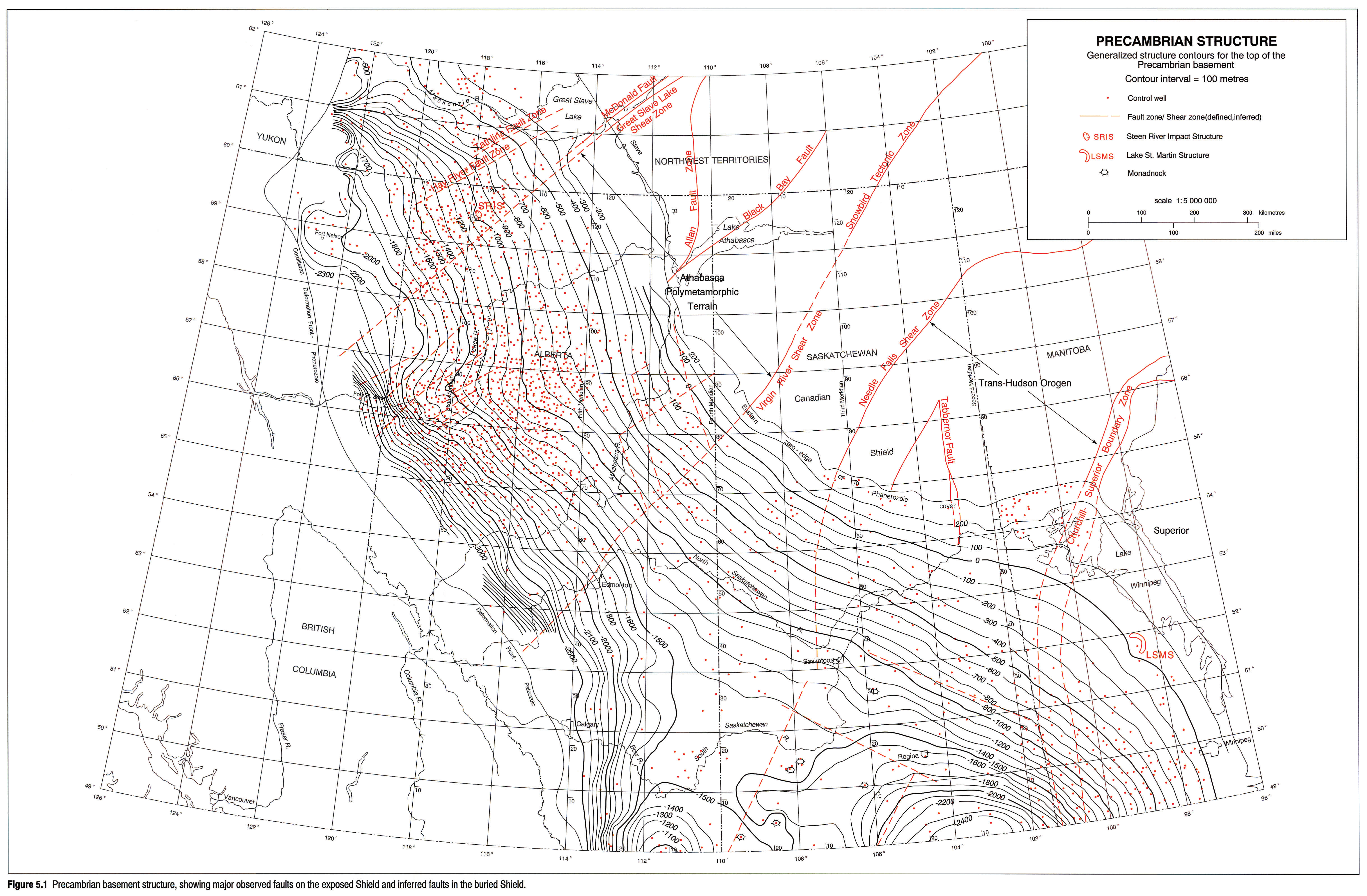
Structure
Figure 5.1 shows the configuration of the unconformity at the base of the Phanerozoic cover. Regional features, the Tathlina, Peace River and Sweetgrass-North Battleford arches, and the intervening Keg River, West Alberta and Williston basins, serve to interrupt the southwest regional dip of this surface. The history of elevation or subsidence of these features is documented in the chapters which follow.
Prior to burial, differential erosion of the softer Precambrian rock units imparted an etched grain to the unconformity. Differences in basement elevation of up to a hundred metres between wells in adjacent townships were noted during compilation of the database. This local topography is smoothed by the contouring program used. Fault scarps are also minimized. A virtual absence of published seismic reflection data limits direct mapping of basement faults across the basin floor. Notable exceptions are the delineations of the southern Alberta rift (Kanasewich, 1968) and the Churchill-Superior Boundary zone (Hajnal and Fowler, 1982).
The western margin of the Shield adjacent to the WCSB is cut by a number of faults and shear zones of regional extent. At Great Slave Lake, the topographically distinct McDonald fault (MDF, Fig. 5.1) is one of a series of northeast-trending, brittle zone, late Hudsonian lineaments (Henderson et al., 1990). All of these run subparallel to the older Great Slave Lake shear zone (GSLSZ). The dextral movement of the GSLSZ is also characteristic of the Black Bay fault, the Virgin River shear zone and the Needle Falls shear zone (Fig. 5.1). This entire segment of the crust appears to have been subjected to a similar stress field at about 2000 Ma (Byers, 1962). The Churchill-Superior boundary zone (CSBZ) is interpreted by Bleeker (1990) as a zone of collision with sinistral transcurrent movement. The north-trending Allan fault zone is early Hudsonian and has been subjected to recurrent movement after regional metamorphism. The Tabbernor fault defines the east boundary of the Archean Glennie Lake domain, within the Trans-Hudson Orogen (THO).
The northeast-trending faults of the East Arm of Great Slave Lake continue in the subsurface as the Tathlina (TFZ) and Hay River fault zones (HRFZ; Williams, Fig. 2, 1990). The GSLSZ can be traced as far west as the eastern edge of the Cordillera by its aeromagnetic signature (Ross et al., this volume, Chapter 4). Conjugate northeast-northwest-trending faults control the basement topography and sedimentation patterns over the Peace River Arch (Cant, 1988). Vertical movements totalling several hundred metres occurred along these faults in late Paleozoic time. In northeastern Alberta, a series of north-south lineaments, offset by later northeast-trending faults, were inferred by Garland and Bower (1959).
Offsets in linear gravity anomalies were used by Gent (1989) to define fault trends in the subsurface of Saskatchewan. These faults bear little obvious relation to those mapped on the exposed Shield. A set of conjugate faults between 102 and 106°W, 49 and 52°N, may represent the late, brittle stage of deformation of the THO. The position of the CSBZ in the subsurface is now defined (Weber, 1990). This boundary zone may have been active in Paleozoic time as indicated by the disturbance of Paleozoic strata.
The fundamental cause of the differential uplift of arches, especially the Peace River Arch, has been a subject of continued discussion. Burwash and Krupicka (1970) suggest isostatic control. Cant (1988) and Stephenson et al. (1989) favour crustal flexure related to Cordilleran tectonics. Ross (1990) suggests that the Arch reflects a passive, flexural-isostatic feature rather than an area of thermal-extensional tectonics.
Petrology
Data presented here are based primarily on Precambrian basement core samples accumulated at the University of Alberta over four decades. McGregor (1986) used cuttings to define the subsurface lithological belts of southwestern Manitoba, and Ross et al. (1989) separated zircons from cuttings from Alberta wells for U-Pb isotopic analyses.
Petrography
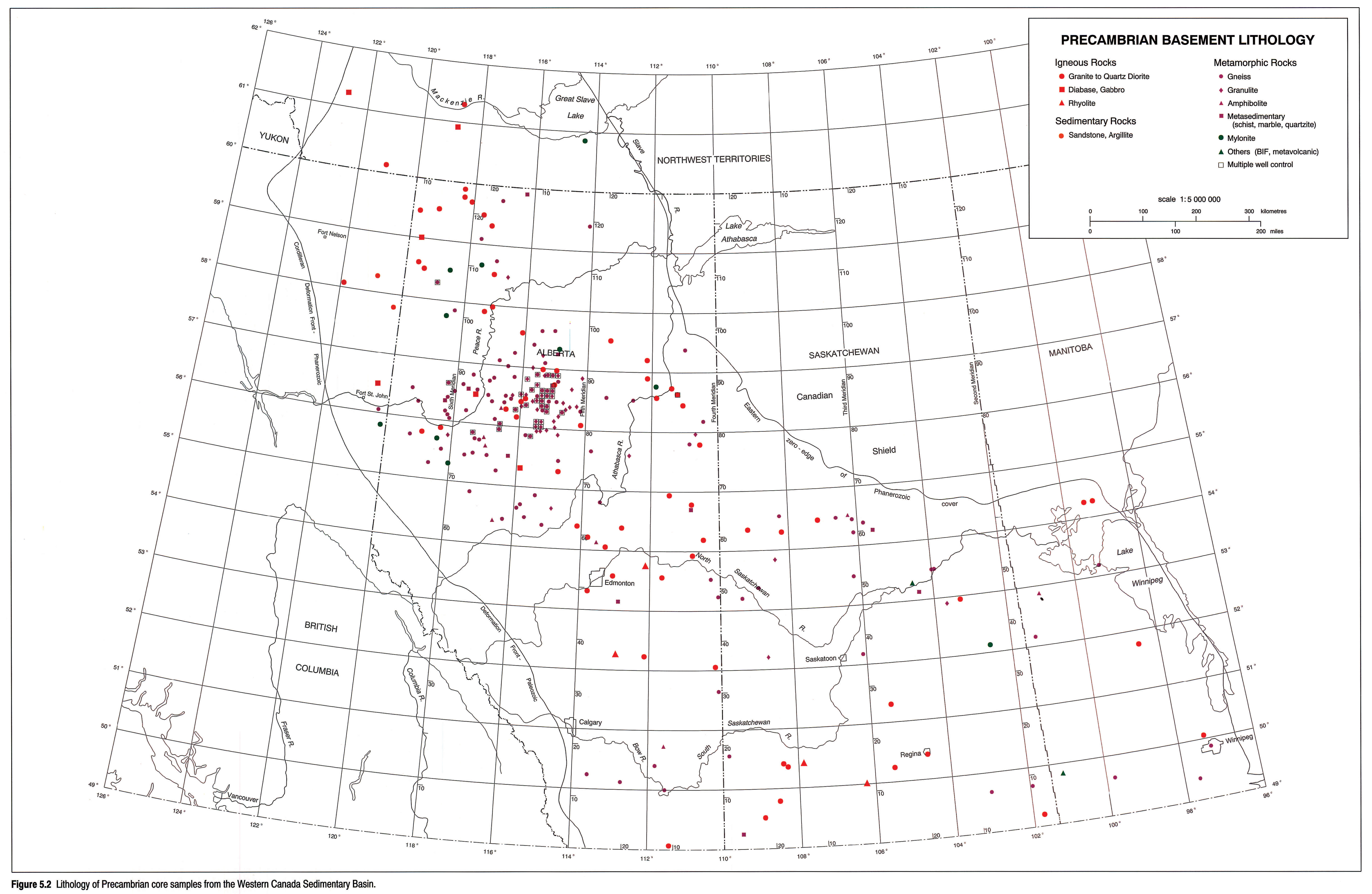
Basement lithology is mapped in Figure 5.2 and the legend for the figure is adopted from Burwash et al. (Fig. 3.10, in press). That manuscript also contains an extended discussion of the distribution and abundance of the data. The most abundant rock types are quartzo-feldspathic gneiss (58%), granitoids (16%), granulites (5%), metasedimentary rocks (5%), mylonites (5%) and amphibolites (4%). All other types constitute three per cent or less. Recent petrography by Burwash and Power (1991) suggests that the true abundance of granulites and retrogranulites may be closer to ten percent.
Although the abundance of rock types varies spatially, defining boundaries between terranes on this basis is difficult. High grade metamorphic and/or deep-seated igneous rocks are dominant in all areas. Classifications based purely on mineralogy are inadequate because many of the rocks show evidence of deformation subsequent to their original crystallization. The post-crystalline deformation is in turn accompanied or followed by recrystallization (Burwash and Krupicka, 1969; Burwash, 1978). The semiquantitative scales of deformation and recrystallization developed by Burwash and Krupicka (op. cit.) thus become critical factors in our petrographic classification. A comparison can be made between subsurface extensions of the THO and the northern Alberta belt, which includes the Peace River Arch (Athabasca Polymetamorphic Terrane, APT, of Burwash et al., in press). In the buried THO, Precambrian supracrustal rocks (schist, banded iron formation, and metavolcanics) form nearly 30 percent of the samples, compared to about 40 percent for gneisses and granulites. In the APT, supra-crustal rocks form less than five percent and gneisses and granulites more than 80 percent. The APT has thus been eroded to a much deeper crustal level than the THO.
Geochemistry
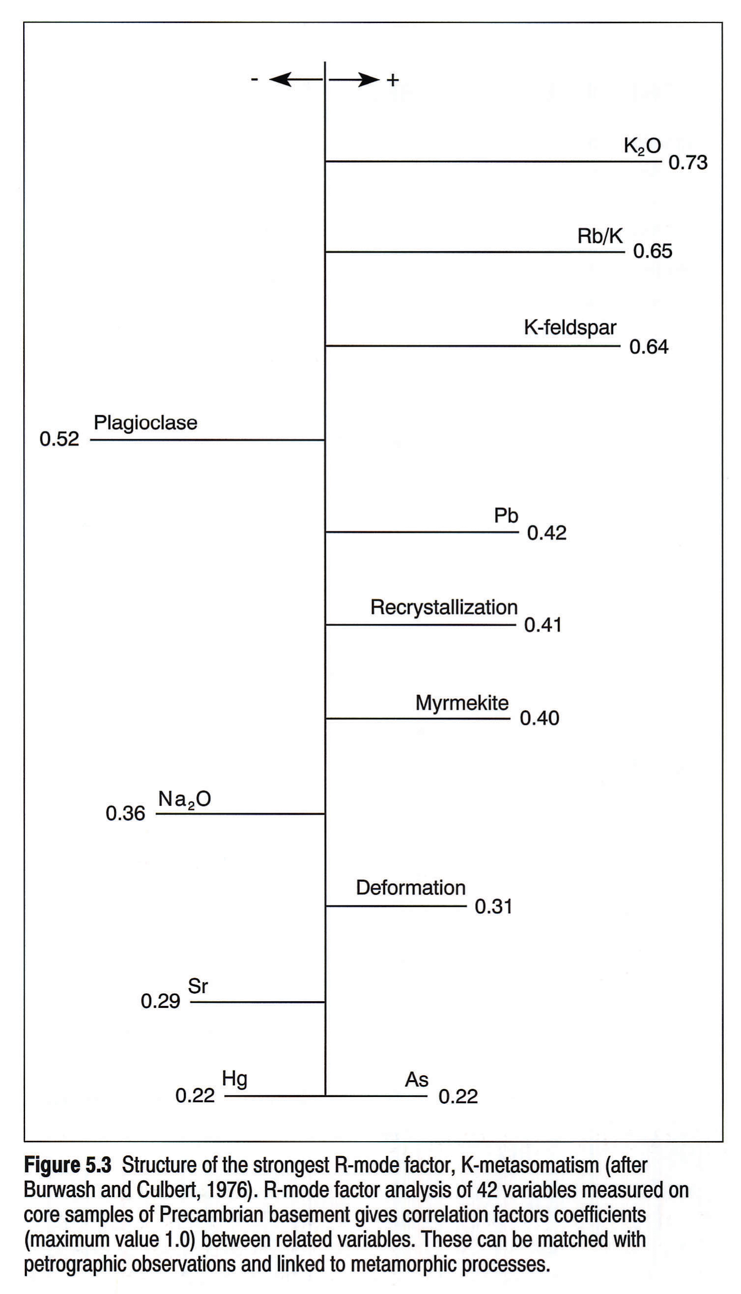
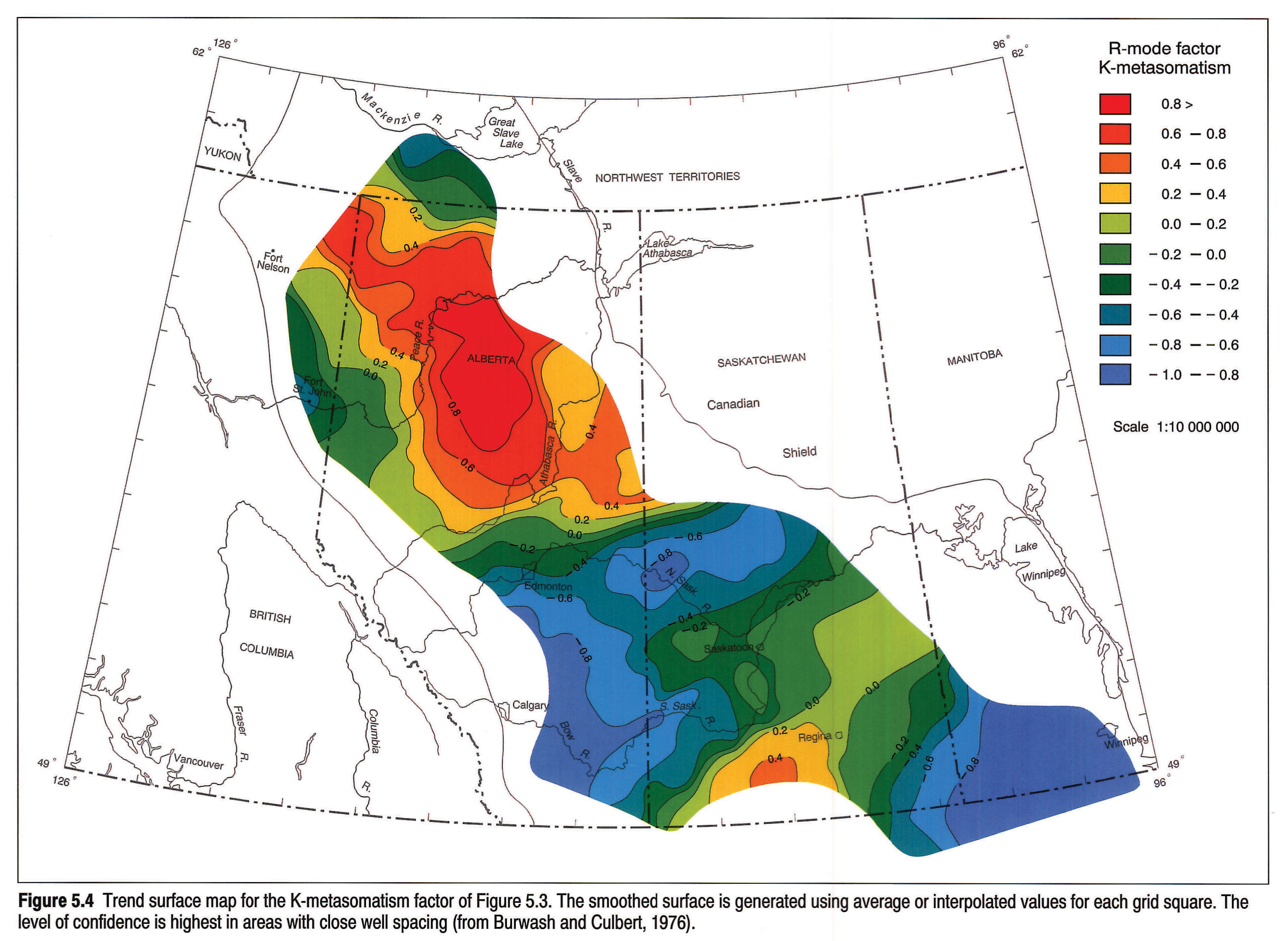
For the purpose of multivariate analysis, data from analyses of whole-rock samples for selected minor and all major elements were combined with petrographic data by Burwash and Culbert (1976). The two most useful methods proved to be R-mode and canonical analysis. Figure 5.3 shows the correlation of variables with the strongest R-mode factor, which is designated K-metasomatism. Figure 5.4 is a trend surface map generated for this factor (1A in Fig. 1; Burwash and Culbert, 1976).
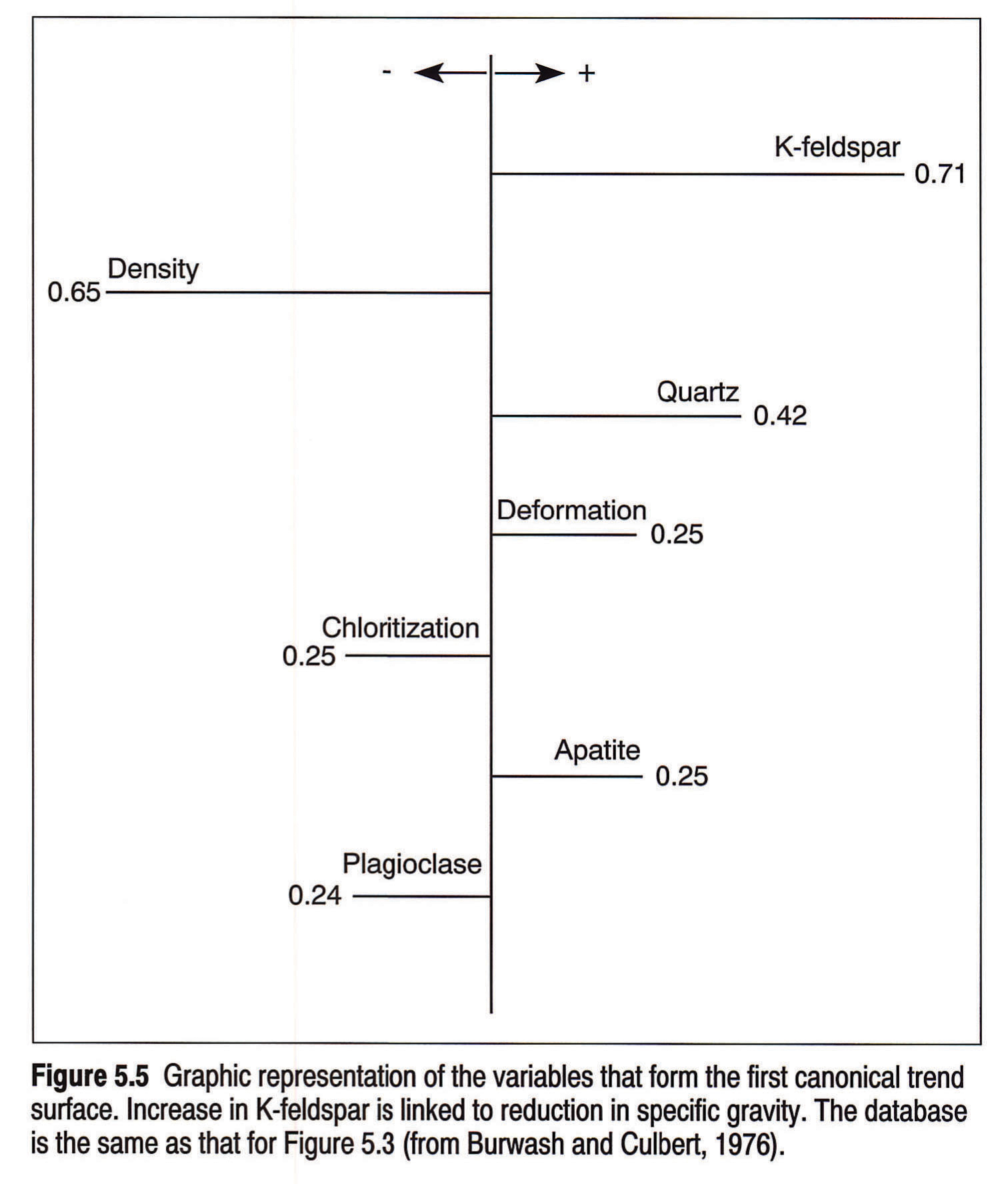
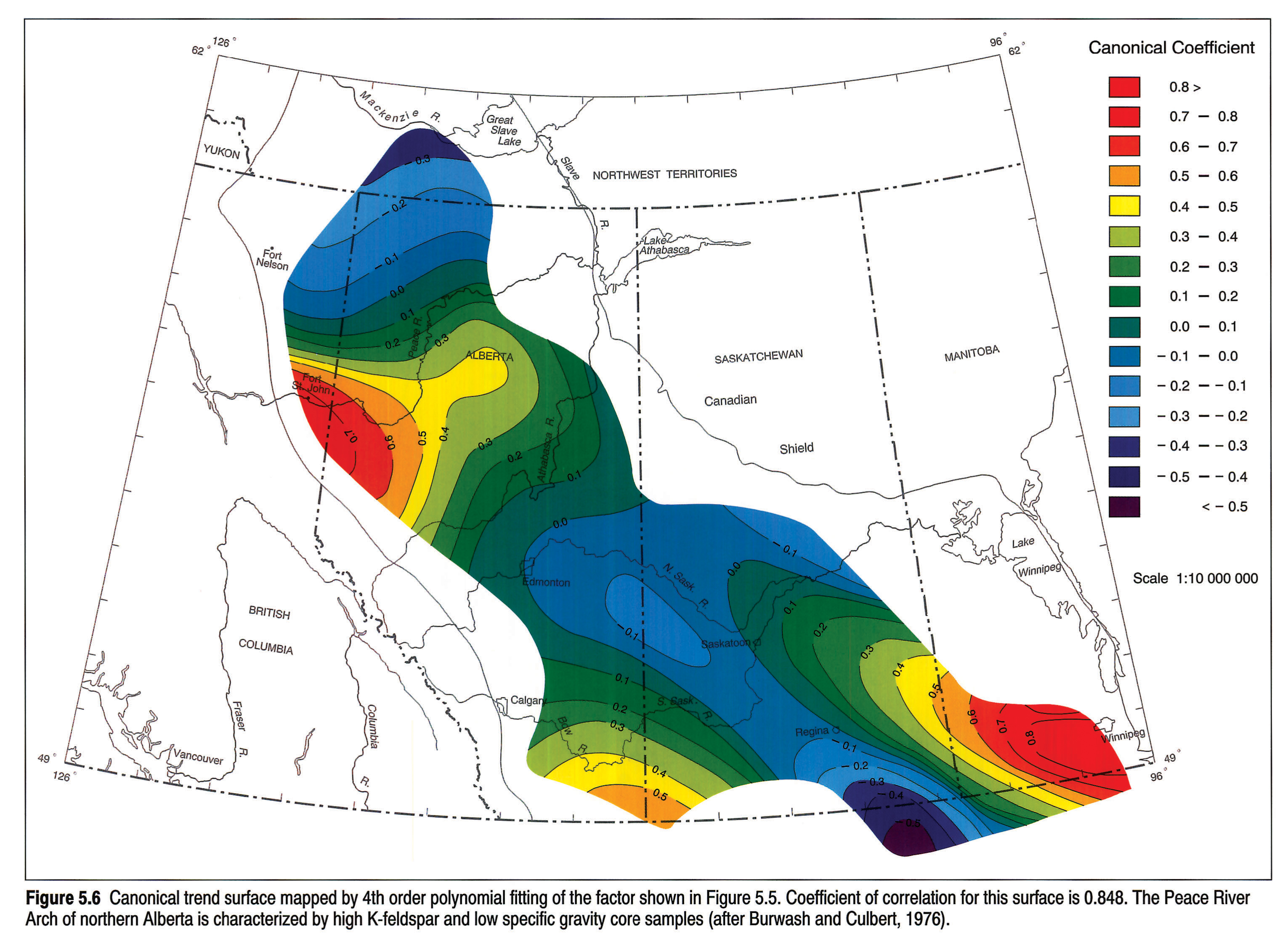
Canonical trend analysis differs from R-mode analysis in its inclusion of X-Y geographic coordinates as variables. By using this technique, canonical coefficients are determined (Fig. 5.5) and mapped as a trend surface (Fig. 5.6). The geological process identified is again K-metasomatism; the geographic area is a northeast-trending belt across northern Alberta. On both petrographic and geochemical grounds the Peace River Arch and its flanks are distinct from adjacent terranes.
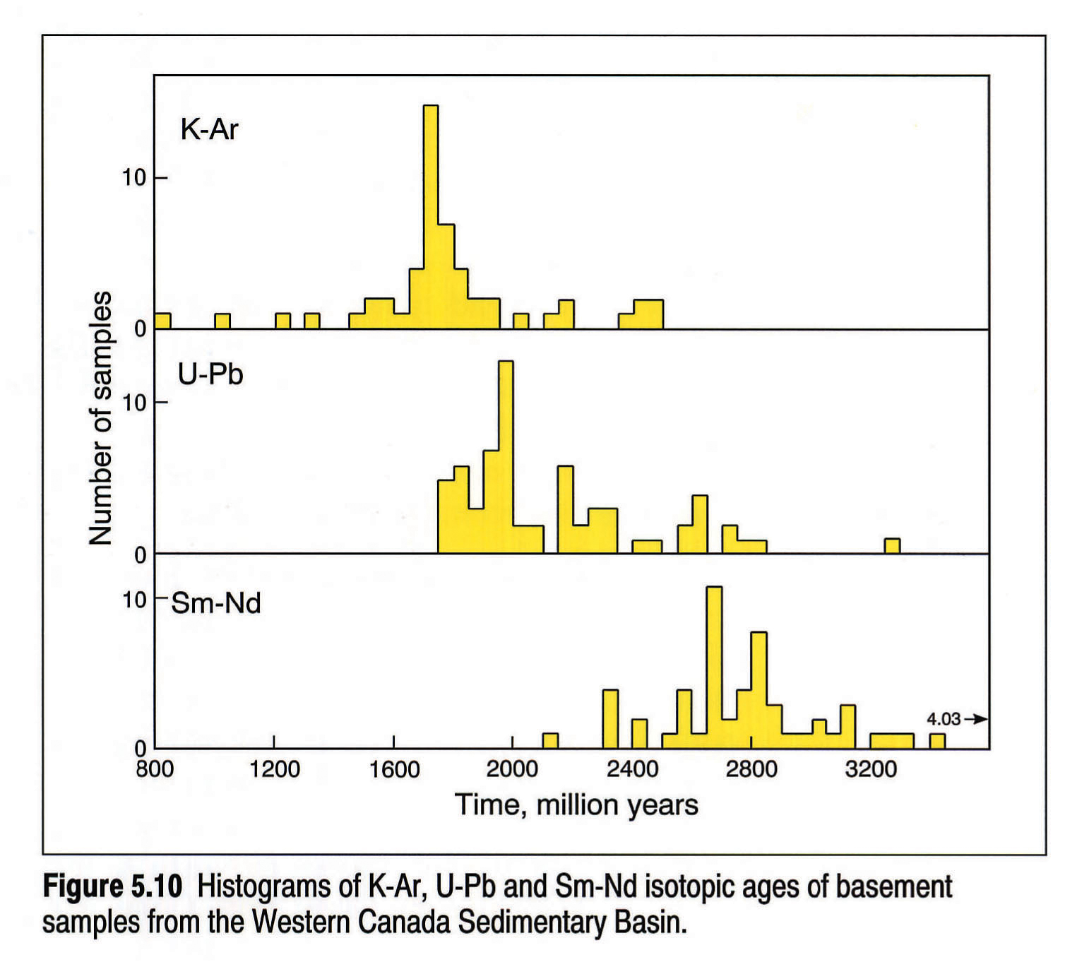
Geochronology
The K-Ar, U-Pb and Sm-Nd methods of isotopic age determination have been applied to regional studies of the WCSB (Figs. 5.7, 5.8, 5.9). Rb-Sr dating has been used at a few localities. Each method provides a valuable, but different, kind of information. K-Ar age determinations were used in the 1950s and 60s as a rapid reconnaissance tool to outline the main structural provinces of the buried and exposed Canadian Shield (Burwash et al., 1962; Stockwell, 1963; Wanless, 1970). For biotite, the most widely used mineral, the blocking temperature for escape of radiogenic argon is approximately 300°C. In regional studies, the dates obtained represent the time of uplift of that crustal segment above the 300° isotherm. The K-Ar method, when applied to the WCSB, identified the extension of the Archean Superior Province beneath most of southwestern Manitoba (Peterman, 1962). Three hornblende separates from north-central Alberta have values of 2000 to 2200 Ma. These are assumed to be indicators of an older crustal element. The remainder of the floor of the basin cooled during the time interval from 1800 to 1700 Ma (Fig. 5.7).
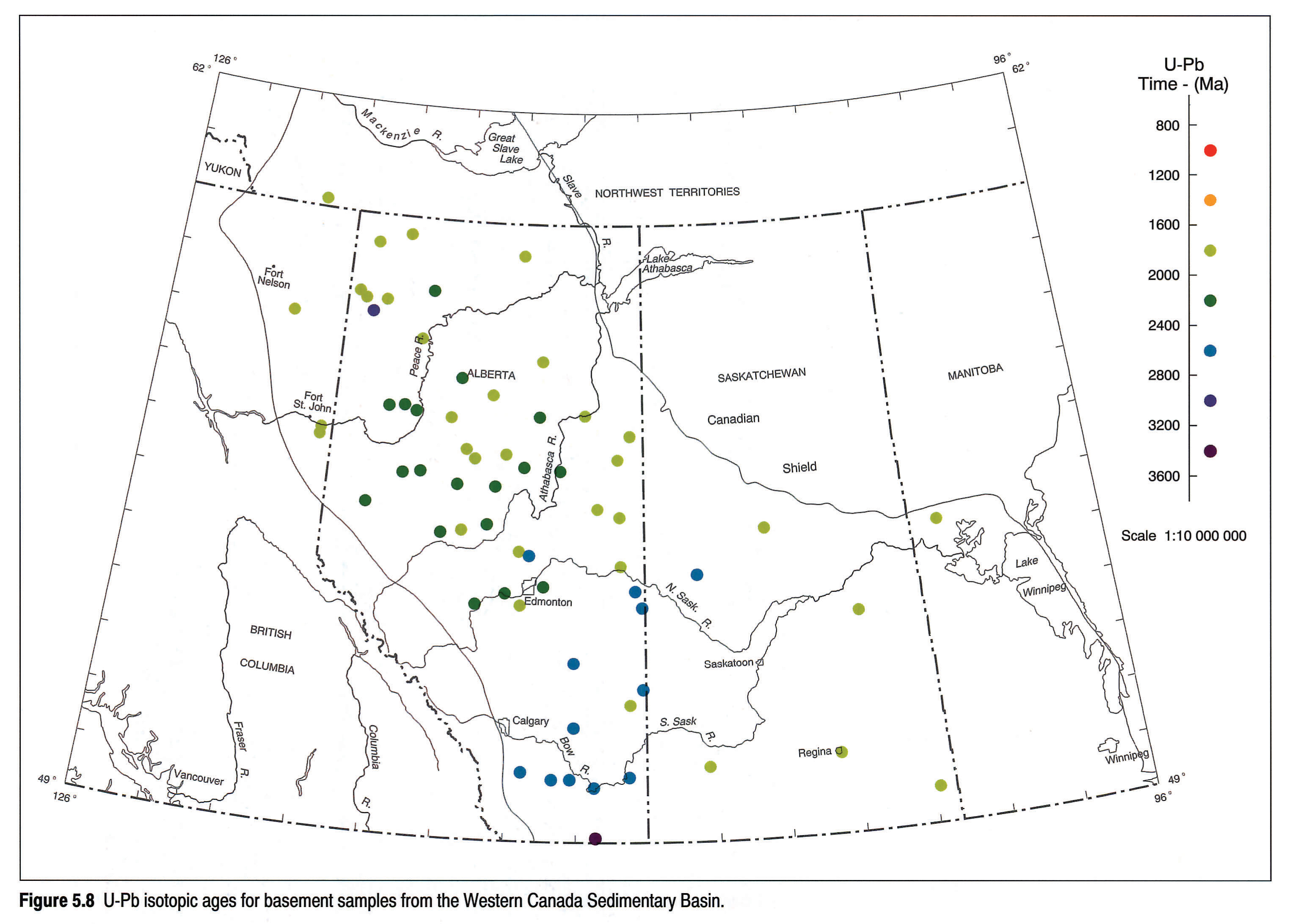
U-Pb isotopic analyses of zircon provide a method of high resolution that can be applied to small volumes of rock, such as oil-well drill cuttings (Fig. 5.8). Ross et al. (1989) used data from cores and cuttings from Alberta wells and supplementary aeromagnetic data to define basement domains. The U-Pb dates are inferred to be the times of crystallization of the zircon from a magma, or the culmination of a metamorphic event. The histogram in Figure 5.10 adds Saskatchewan data from Collerson et al. (1988) to that of Ross et al. (1989).
The distribution of U-Pb zircon data shows two peaks between 2000 and 1750 Ma (Fig. 5.10). The early Hudsonian (2000-1900 Ma) samples are more numerous than the late Hudsonian (1850-1750 Ma). Kenoran events (2650-2550 Ma) are represented and are distinct from an earlier event characteristic of the northern extension of the Wyoming and western Superior provinces. Two samples in the 2500 to 2400 range match a granulite facies event widely documented in northwestern Saskatchewan (Koster and Baadsgaard, 1970), northeastern Alberta (Burwash et al., 1985), and the adjacent Northwest Territories (Banks, 1980).
Between 2350 and 2000 Ma the WCSB histogram of U-Pb zircon age determinations shows a maximum at approximately 2200 Ma. Ross et al. (1989) interpreted this as the time of formation of the Buffalo Head Domain, a recently identified crustal segment in northern Alberta. An alternative explanation is provided by Bostock et al. (1991), working in the eastern foreland of the Taltson magmatic arc of the Northwest Territories, and by Bickford et al. (1988), working in the Mudjatic belt of northwestern Saskatchewan. Both attribute a number of U-Pb ages, which fall in the 2400 to 2000 Ma range, to the inheritance of Archean lead in zircons recrystallized during the Hudsonian.
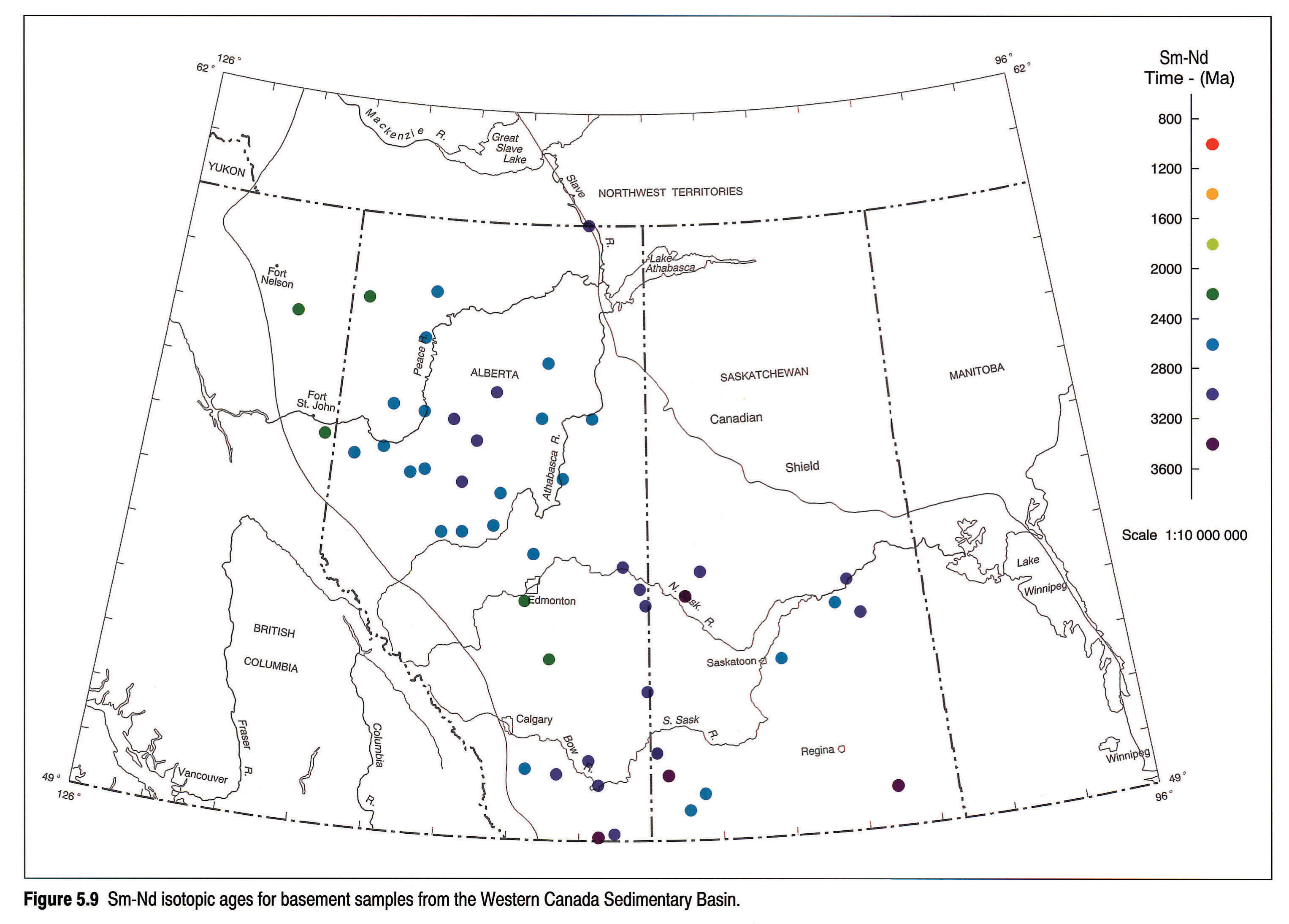
The Sm-Nd isotopic data shown on Figures 5.9 and 5.10 is the inferred time of separation of sialic crustal material from the mantle and is usually referred to as the time of crustal residence (tCR). Early work by DePaolo and Wasserburg (1976) used a mantle composition modelled on chondritic meteorites (CHUR). A depleted mantle model (Goldstein et al., 1984) is currently favoured and is used to determine all ages shown on the histogram in Figure 5.10 (Frost and Burwash, 1986; Collerson et al., 1988; Theriault and Ross, 1991). Depleted mantle model ages (tDM) from the WCSB fall in the range 3400 to 2400 Ma, with a peak at about 2650 Ma, the time of the Kenoran Orogeny. The 2800 Ma event indicated by U-Pb data is also reflected in the Sm-Nd histogram. The values in excess of 3000 Ma may reflect the inheritance of Nd from Middle or Early Archean crust, as is the case in the northern Slave and western Superior provinces, or they may represent an inappropriate choice of mantle model.
Archean crust, or an Archean crustal component, occurs at all the dated localities plotted in Figure 5.9. Varying ratios of juvenile Proterozoic material have been added to the Hudsonian magmatic arcs (Collerson et al., 1989; Theriault and Ross, 1991). The Sm-Nd data thus support the concept of crustal recycling by deformation and metasomatism suggested by Burwash and Krupicka (1969, 1970).
Meteorite Impact Zones
Several areas of marked local topographic relief on the Precambrian surface can be recognized in the WCSB. One of these, near Lake St. Martin, Manitoba (LSMS, Fig. 5.1), brings Precambrian basement to the surface in an arcuate pattern (Manitoba Mineral Resources Division, 1979). Shocked granite at this site, with a 2387 Ma K-Ar biotite age, is inferred to be part of a meteorite impact ring structure (McCabe and Bannatyne, 1970). Two Precambrian granite inliers near High Rock Lake, south of Lake St. Martin, suggest a circular feature of very complex origin (McCabe, 1981; 1982).
An arcuate pattern is inferred for the Steen River Impact Structure (SRIS, Fig. 5.11) located in northwestern Alberta. The SRIS is a circular basement feature, 25 km in diameter. A central uplift raises fractured, partly melted basement 800 to 1000 m above the regional level. This is surrounded by a rim syncline, which locally downthrows the basement by more than 500 m. A raised rim forms a positive feature of a few tens of metres, and the whole is surrounded by an irregular disturbed zone extending up to 30 km from the centre. This disturbed zone may contain a second raised rim.
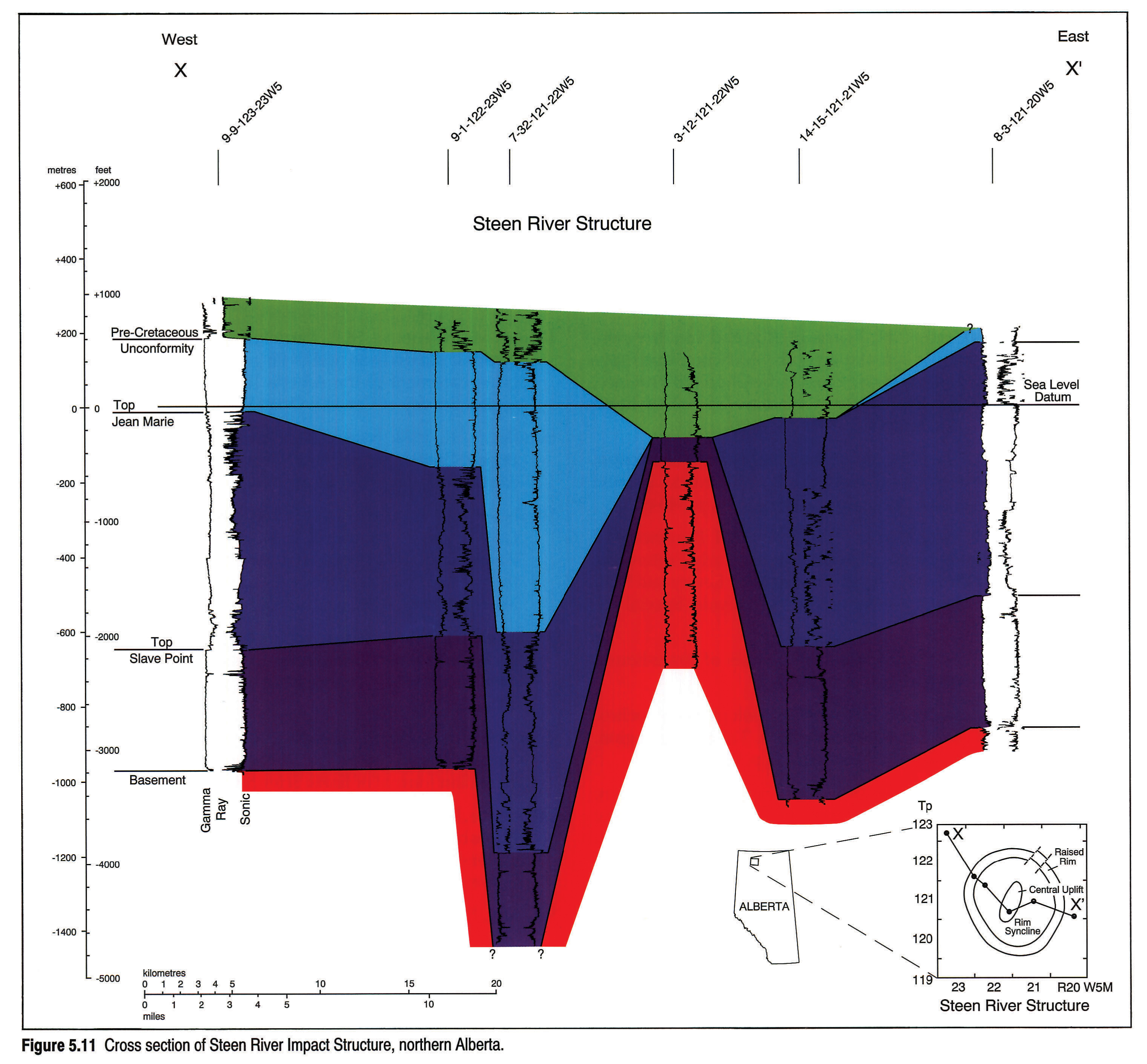
In addition to the basement, at least 1000 m of Devonian carbonates, evaporites and shales are tectonically disturbed by the structure. The SRIS was only slightly modified by the pre-Cretaceous unconformity prior to the deposition of about 200 m of mid-Cretaceous marine shale. Seismic sections across the structure show a pattern of small-scale normal faults forming horsts and grabens in the disturbed zone and cutting the raised rim. Within the rim syncline, the structure is extremely complex, with overthrusting disturbing and inverting the normal stratigraphic succession.
The SRIS may have been modified by post-impact movement on the subsurface extension of the GSLSZ and the faulted boundary between the Hottah Terrane and the Great Bear Magmatic Arc. Movement on these features may have been triggered by the impact. Hydrocarbon-rich structural traps, both within the SRIS and along the GSLSZ, may be the result of this impact event.
Evidence for an extraterrestrial origin for the SRIS is limited to the overall shape of the structure and study of the mineralogy and shock metamorphic textures within the central uplift (Carrigy, 1968; Winzer, 1972). K-Ar dating of partially melted basement indicates an age of 95 ± 7 m.y. for the impact (Carrigy, 1968).
The SRIS is intriguingly close in age to the similar Boltysh structure in the Ukraine (1005 Ma), and may be evidence of a multiple impact event at that time. It also has apparent similarities to the larger Montagnais structure on the Scotian Shelf. This may be due to them both being the result of marine impacts. The presence of hydrocarbons within the SRIS also invites comparison with well known hydrocarbon producers such as Red Wing Creek in North Dakota and Viewfield in Saskatchewan. The continued study of the SRIS will shed light on the recognition and economic potential of buried basement features within the WCSB.
Discussion
Any preparation of a geological map of the subsurface Precambrian of the WCSB must be based on all available geological and geophysical data. In the absence of the constraints imposed by outcrop mapping, rational models are also essential. Our model is based on two salient hypotheses. The first suggests that most of the WCSB is floored by rocks that formed during either the Kenoran or Hudsonian orogenies (as defined by Stockwell, 1963), or that they are Archean or Lower Proterozoic rocks that have been exposed to Hudsonian metamorphic overprinting. The second hypothesis, supported by Sm-Nd isotopic data, indicates that almost all of the WCSB is underlain by sialic crust that was differentiated from the mantle during the Archean, with linear belts to which a significant juvenile Proterozoic component has been added.
The Kenoran rocks (2800 - 2400 Ma) include volcanic belts and their related hypabyssal intrusions, major batholitic complexes and, finally, the uplifted granulite blocks common in northern Saskatchewan and adjacent Alberta and the Northwest Territories. Early and Middle Archean rocks (greater than 2900 Ma) occur in the exposed parts of the Slave, Superior and Wyoming provinces. The northern extension of the Wyoming craton into southern Alberta is indicated by a U-Pb zircon age of 3278 + 22/-21 from a basement core at 49°04'N, 111°26'W (Villeneuve et al., in press). The Slave and Superior provinces extend beneath the Phanerozoic cover of the southern District of Mackenzie and southwestern Manitoba (Fig. 5.12).
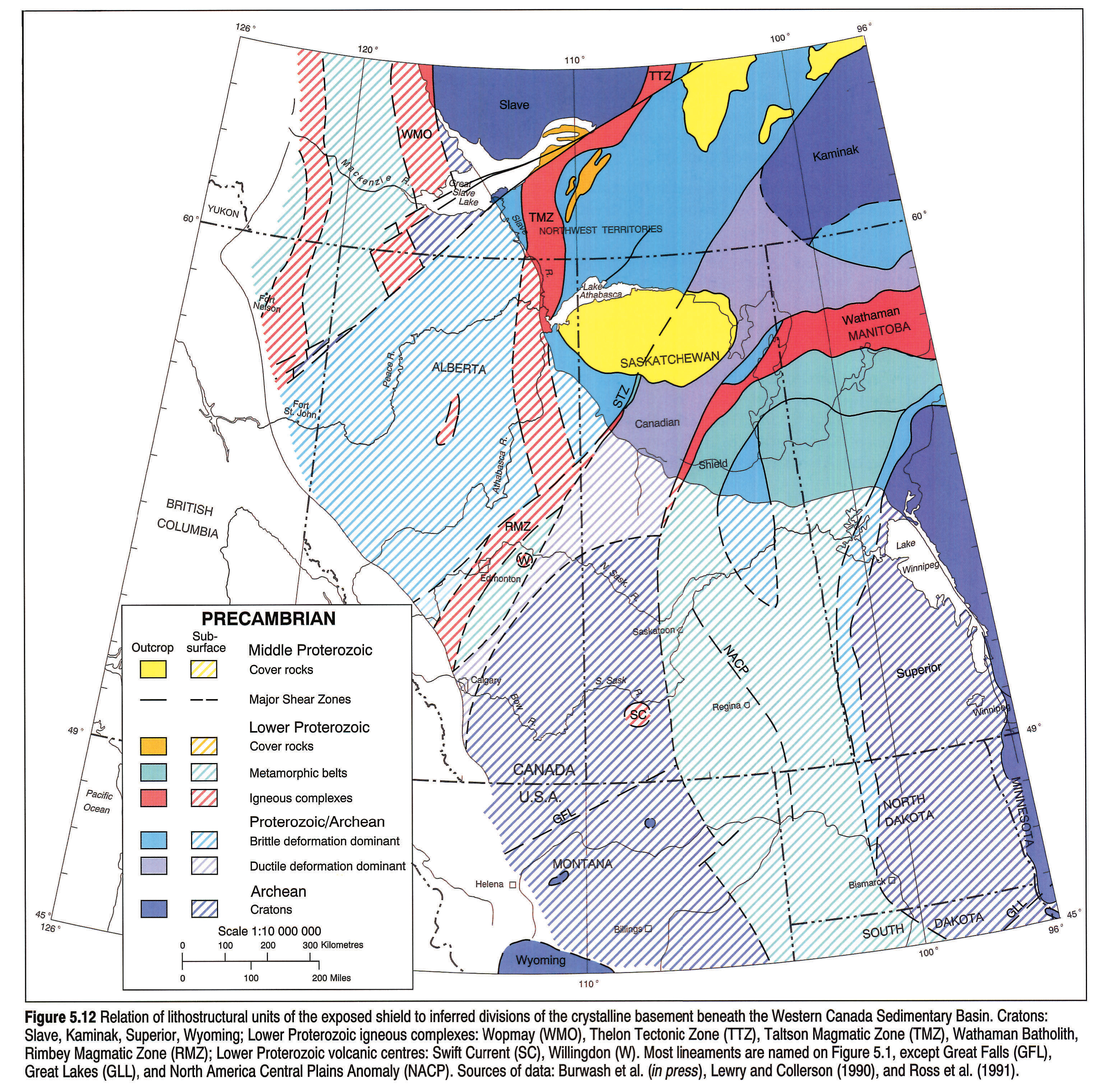
Three Hudsonian magmatic belts can be traced from the exposed Shield beneath the WCSB. To the west of the Slave Province, the Wopmay Orogen (WMO) extends beneath the cover rocks of the Northern Interior Plains and it is truncated by the TFZ and HRFZ, and by the GSLSZ. The southern continuation of the WMO probably occurs near the Alberta-British Columbia boundary, west of the Archean core sample, along the GSLSZ (Fig. 5.8). To the east of the Slave Province, the Thelon Tectonic Zone (TTZ) is offset along the Bathurst and McDonald fault systems. Its southern extension, the Taltson Magmatic Zone (TMZ) (Bostock et al., 1991) can be traced southward from the GSLSZ to the Snowbird Tectonic Zone (STZ, Fig. 5.12).
The thermal axis of the THO in Saskatchewan and Manitoba is defined by the linear Wathaman batholith (Stauffer, 1984). The subsurface extension of the THO has been linked to the North American Central Plains conductivity anomaly, but a causal relation between the two is difficult to establish (Burwash et al., in press). The Swift Current area of southwestern Saskatchewan has a number of Hudsonian epizonal plutons and volcanic centres younger than, but tectonically aligned with, the Wathaman batholith. The tectonic significance of the Willingdon volcanic centre east of Edmonton (Burwash, 1955, 1957) remains obscure.
Rb-Sr dating of the intracratonic indentation of the Slave Province into the TTZ (Henderson et al., 1990) fixes the time of the late brittle faulting between 1840 and 1735 Ma. The northeast- and northwest-trending faults form a conjugate set, also seen in the WMO. The major shear zones of the northwestern Shield, oriented northeast or north (Byers, 1962), formed prior to or during the main Hudsonian thermal event. The widespread cataclasis and metasomatism in the terrane between the GSLSZ and the STZ is related to the older shear zones. Cataclasis can reduce the magnetic susceptibility of mafic gneisses by several orders of magnitude (Watanabe, 1966), resulting in linear negative aeromagnetic anomalies. The less deformed rocks, by contrast, become magnetic highs.
The present-day North American craton, as drawn by Hoffman (1988, 1990) and by Lewry and Collerson (1990), has four Archean cratons: the North Atlantic, the Superior, the Slave and the Wyoming. To these may be added the Kaminak, west of Hudson Bay (Burwash et al., in press). The Superior, Slave and Wyoming cratons and their extensions play a critical role in the basement of the WCSB. A series of northeast-trending major tectonic zones segment or bound the Archean crustal blocks of western North America. These include the GSLSZ, STZ, and the Great Falls, Cheyenne and Great Lakes lineaments (Peterman and Futa, 1987). Late transcurrent movement along these lineaments commonly leaves a clear magnetic signature, especially where it offsets magmatic arcs. Phanerozoic reactivation of some of the lineaments has played an important role in the stratigraphic record of the WCSB.
Acknowledgements
Many Canadian oil companies have provided basement core samples to the University of Alberta collection. The staffs of the ERCB Core Research Centre, Calgary, and the Subsurface Geological Laboratory, Regina, provided generous help to R.A. Burwash on his numerous collecting trips. Financial assistance has been provided by the National Science and Engineering Research Council, the Geological Survey of Canada and the University of Alberta Research Fund.
Numerous individuals who have assisted the basement studies are gratefully acknowledged. They include H. Baadsgaard, Z.E. Peterman, J. Krupicka, R.R. Culbert, C.R. Stelck, E.R. Kanasewich, A.G. Green, A.M. Jessop, G.M. Ross, C.D. Frost and P.A. Cavell. Special thanks go to Ruth W. Burwash, who assisted in sample preparation, and edited and transcribed the manuscript.
References
- Bachu, S. and Burwash, R.A. (this volume). Geothermal regime in the Western Canada Sedimentary Basin. In: Geological Atlas of the Western Canada Sedimentary Basin. G.D. Mossop and I. Shetsen (comps.). Calgary, Canadian Society of Petroleum Geologists and Alberta Research Council, chpt. 30.
- Banks, C.S. 1980. Geochronology, general geology and structure of Hill Island Lake-Tazin Lake areas. Unpublished M.Sc. thesis, University of Alberta, Edmonton, 109 p.
- Bickford, M.E., Collerson, K.D., and Lewry, J.F. 1988. U-Pb geochronology and isostatic studies of the Trans-Hudson Orogen in Saskatchewan. In: Summary of Investigations 1988. Saskatchewan Geological Survey, Miscellaneous Report 88-4, p. 35-41.
- Bleeker, W. 1990. New structural-metamorphic constraints on Early Proterozoic oblique collision along the Thompson Nickle Belt, Manitoba, Canada. In: The Early Proterozoic Trans-Hudson Orogen of North America. J.F. Lewry and M.R. Stauffer (eds.). Geological Association of Canada Special Paper 37, p. 57-73.
- Bostock, H.H., van Breemen, O., and Loveridge, W.D. 1991. Further geochronology in northern Talston Magmatic Zone, District of Mackenzie, N.W.T. In: Radiogenic age and Isotopic Studies: Report 4, Geological Survey of Canada, Paper 90-2.
- Burwash, R.A. 1955. A reconnaissance of the subsurface Precambrian of the Province of Alberta, Canada. Unpublished Ph. D. thesis, University of Minnesota, 74 p.
- Burwash, R.A. 1957. Reconnaissance of subsurface Precambrian of Alberta. American Association of Petroleum Geologists, Bulletin 41, p. 70-103.
- Burwash R.A. 1978. Metamorphism of the Athabasca Mobile Belt, a subsurface extension of the Churchill Province. In: Metamorphism in the Canadian Shield, Geological Survey of Canada, Paper 78-10, p. 123-127.
- Burwash, R.A., Baadsgaard, H., and Peterman, Z.E. 1962. Precambrian K-Ar dates from the western Canada sedimentary basin. Journal of Geophysical Research, v. 67, p. 1617-1625.
- Burwash, R.A., Baadsgaard, H., Peterman, Z.E., and Hunt, G.H. 1964. Chapter 2, Precambrian. In: Geological History of Western Canada. R.G. McCrossan and R.P. Glaister (eds.). Alberta Society of Petroleum Geologists, p. 14-19.
- Burwash, R.A. and Burwash, R.W. 1989. A radioactive heat generation map for the subsurface Precambrian of Alberta. In: Current Research, Part C, Geological Survey of Canada, Paper 89-1C, p. 363-368.
- Burwash, R.A. and Culbert, R.R. 1976. Multivariate geochemical and mineral patterns in the Precambrian basement of western Canada. Canadian Journal of Earth Sciences, v. 13, p. 1-18.
- Burwash, R.A., Green, A.G., Jessop, A.M. and Kanasewich, E.R.(in press). Geophysical and petrologic characteristics of the basement rocks. In: Continental Platforms and Basins of Canada, D.F. Stott and J.D. Aitken (eds.). Geology of North America, Geological Survey of Canada.
- Burwash, R.A. and Krupicka, J. 1969. Cratonic reactivation in the Precambrian basement of western Canada, I: Deformation and chemistry. Canadian Journal of Earth Sciences, v. 6, p. 1381-1396.
- Burwash R.A. and Krupicka, J. 1970. Cratonic reactivation in the Precambrian basement of western Canada, II: Metasomatism and isostacy. Canadian Journal of Earth Sciences, v. 7, p. 1275-1295.
- Burwash, R.A., Krupicka, J., Basu, A.R., and Wagner, P.A. 1985. Resetting of Nd and Sr whole-rock isochrons from polymetamorphic granulites, northeastern Alberta. Canadian Journal of Earth Sciences, v. 22, p. 992-1000.
- Burwash, R.A. and Power, M.A. 1991. Trout Mountain anomaly, northern Alberta: its role in the northwest foreland of the Trans-Hudson orogen. In: The Early Proterozoic Trans-Hudson Orogen of North America. J.F. Lewry and M.R. Stauffer (eds.). Geological Survey of Canada, Special Paper 37, p. 301-311.
- Byers, A.R. 1962. Major faults in the western part of Canadian Shield with special reference to Saskatchewan. In: The Tectonics of the Canadian Shield. J.S. Stevenson (ed.). Royal Society of Canada, Special Publication 4, p. 40-59.
- Cant, D.J. 1988. Regional structure and development of the Peace River Arch, Alberta. Bulletin of Canadian Petroleum Geology, v. 36, p. 284-295.
- Carrigy, M.A. 1968. Evidence for shock metamorphism in rocks from the Steen River structure, Alberta. In: Shock Metamorphism of Natural Materials. B.M. French and N.M. Short (eds.). Monogram, Geological Society of America, Special Paper 190, p. 367-378
- Collerson, K.D, Van Schmus, R.W., Lewry, J.F., and Bickford, M.E. 1988. Buried Precambrian basement in south-central Saskatchewan: provisional results from Sr-Nd model ages and U-Pb zircon geochronology. In: Summary of Investigations 1988, Saskatchewan Geological Survey. Saskatchewan Energy and Mines, Miscellaneous Report 88-4, p. 142-150.
- Collerson, K.D., Van Schmus, R.W. Lewry, J.F., and Bickford, M.E. 1989. Sm-Nd isotopic constraints on the age of the buried basement in central and southern Saskatchewan: implications for diamond exploration. In: Summary of Investigations 1989, Saskatchewan Geological Survey. Saskatchewan Energy and Mines, Miscellaneous Report 89-4, p. 168-171.
- DePaolo, D.J. and Wasserburg, G.J. 1976. Inferences about magma sources and mantle structure from variations of 143Nd/ 144Nd. Geophysical Research Letters, v. 3, p. 743-746.
- Flawn, P.T. 1967. Basement map of North America. 1: 5 000 000. American Association of Petroleum Geologists and United States Geological Survey.
- Frost, C.D. and Burwash, R.A. 1986. Nd evidence for extensive Archean basement in the western Churhill Province, Canada. Canadian Journal of Earth Sciences, p. 1433-1437.
- Garland, G.D. and Bower, M.E. 1959. Interpretation of aeromagnetic anomalies in northeastern Alberta. In: Fifth World Petroleum Congress, Proceedings, Geology and Geophysics, Section 1, p. 787-800.
- Gent, M.R. 1989. Regional Phanerozoic anomalies of Saskatchewan. In: Summary of Investigations 1989, Saskatchewan Geological Survey, Saskatchewan Energy and Mines, Miscellaneous Report 89-4, p. 162-167.
- Goldstein, S.L., O'Nions, R.K., and Hamilton, P.J. 1984. A Sm-Nd isotopic study of atmospheric dusts and particulate from major river systems. Earth and Planetary Science Letters, v. 70, p. 221-236.
- Hajnal, Z. and Fowler, C.M.R. 1982. The earth's crust under the Williston Basin in eastern Saskatchewan and western Manitoba. In: Fourth International Williston Basin Symposium. J.E. Christopher and J. Kaldi (eds.). Special Publication 6, Saskatchewan Geological Society, p. 13-18.
- Henderson, J.B., McGrath, P.H., Theriault, R.J., and van Breemen, O. 1990. Intracratonic indentation of the Archean Slave Province into the Early Proterozoic Zone of the Churchill Province, northwestern Canadian Shield. Canadian Journal of Earth Sciences, v. 27, p. 1699-1713.
- Hoffman, P.F. 1988. United plates of America, the birth of a craton; Early Proterozoic assembly and growth of Laurentia. Annual Reviews of Earth and Planetary Sciences, v. 16, p. 543-603.
- Hoffman P.F. 1990. Subdivision of the Churchill Province and extent of the Trans-Hudson Orogen. In: The Early Proterozoic Trans-Hudson Orogen of North America. J.F. Lewry and M.R. Stauffer (eds.). Geological Association of Canada, Special Paper 37, p. 15-39.
- Kanasewich, E.R. 1968. Precambrian rift: genesis of strata-bound ore deposits. Science, v. 161, p. 1002-1005.
- Koster, F. and Baadsgaard, H. 1970. On the geology and geochronology of northwestern Saskatchewan. I. Tazin Lake region. Canadian Journal of Earth Sciences, v. 7, p. 919-930.
- Lewry, J.F. and Collerson, K.D. 1990. The Trans-Hudson Orogen: extent, subdivision, and problems. In: The Early Proterozoic Trans-Hudson Orogen of North America. J.F. Lewry and M.R. Stauffer (eds.). Geological Association of Canada, Special Paper 37, p. 1-14.
- Manitoba Mineral Resource Division. 1979. Geological map of Manitoba, Scale 1: 1 000 000. Map 79-2.
- McCabe, H.R. 1981. High Rock Lake structure. Manitoba Mineral Resources Division, Report of Field Activities, p. 78-82.
- McCabe, H.R. 1982. High Rock Lake Crater structure. Manitoba Mineral Resources Division, Report of Field Activities, p. 69-74.
- McCabe, H.R. and Bannatyne, B.B. 1970. Lake St. Martin crypto-explosion crater and geology of the surrounding area. Manitoba Mines Branch, Geological Paper 3/70.
- McGregor, C.R. 1986. Subsurface Precambrian of southwestern Manitoba. Mineral Resource Division, Preliminary Map No. 1986 C-1.
- McGregor, C.R., Bezys, R.K., and McCabe, H.R. 1990. Subsurface Precambrian structure of the Grand Rapids and Wekusko Lake area. Manitoba Mineral Resources Division, Preliminary Map 1990 M-2.
- Peterman, Z.E. 1962. Precambrian basement of Saskatchewan and Manitoba. Unpublished Ph.D. thesis, University of Alberta, Edmonton, 317 p.
- Peterman. Z.E. and Futa, K. 1987. Is the Archean Wyoming Province exotic to the Superior craton? Evidence from Sm-Nd model ages of basement cores. Geological Society of America, Abstract with Programs, v. 19, p. 803.
- Ross, G.M. 1990. Deep crust and basement structure of the Peace River Arch region: constraints on mechanism of formation. Bulletin of Canadian Petroleum Geology, v. 38A, p. 25-35.
- Ross, G.M., Broome, J., and Miles, W. (this volume). Potential fields and basement structure - Western Canada Sedimentary Basin. In: Geological History of the Western Canada Sedimentary Basin. G.D.Mossop and I. Shetsen (comps.). Calgary, Canadian Society of Petroleum Geologists and Alberta Research Council, chpt. 4.
- Ross, G.M., Villeneuve, M.E., Parrish, R.R., and Bowring, S.A. 1989. Tectonic subdivision and U-Pb geochronology of the Precambrian basement of the Alberta Basin, western Canada. Geological Survey of Canada, Open File Report 2103.
- Stauffer, M.R. 1984. Manikewan: an Early Proterozoic ocean in central Canada, its igneous history and orogenic closure. Precambrian Research, v. 25, p. 256-281.
- Stephenson, R.A., Zelt, C.A., Ellis, R.M., Hajnal, Z., Morel-a-L'Huissier, P., Mereu, R.F, Northey, D.J., West, G.F., and Kanasewich, E.R. 1989. Crust and upper mantle structure and the origin of the Peace River Arch. Bulletin of Canadian Petroleum Geology, v. 37, p. 224-235.
- Stockwell, C.H. 1963. Second report on structural provinces, orogenies and time classification of rocks of the Canadian Precambrian Shield. Geological Survey of Canada, Paper 62-17, p. 123-133.
- Theriault, R.J. and Ross, G.M. 1991. Nd isotopic evidence for crustal recycling in the ca. 2.0 Ga subsurface of western Canada, Canadian Journal of Earth Sciences, v. 28, p. 1140-1147.
- Villeneuve, M.E., Ross, G.M., and Parrish, R.R. (in press). Geophysical subdivision and U-Pb geochronology of the crystalline basement of the Alberta Basin, western Canada. Geological Survey of Canada, Paper.
- Wanless, R.K. 1970. Isotopic age map of Canada. Geological Survey of Canada, Map 1256A.
- Watanabe, R.Y. 1966. Petrology of cataclastic rocks of northeastern Alberta. Unpublished Ph. D. thesis, University of Alberta, Edmonton, 219 p.
- Weber, W. 1990. The Churchill-Superior boundary zone, southeast margin of the Trans-Hudson Orogen: a review. In: The Early Proterozoic Trans-Hudson Orogen of North America. J.F. Lewry and M.R. Stauffer (eds.). Geological Association of Canada, Special Paper 37, p. 15-39.
- Williams, G.K. 1990. Tectonics and structure, Mackenzie corridor, Northwest Territories. Geological Survey of Canada Open File Report 2248, 36 p.
- Wilson, J. A. 1986. Geology of the basement beneath the Athabasca Basin in Alberta. Alberta Geological Survey, Bulletin 55, 61p.
- Winzer, S.R. 1972. The Steen River astrobleme, Alberta, Canada. 24th International Geological Congress, Section 15, p. 148-156.