Chapter 6 - Proterozoic and Lower Cambrian Strata of the Western Canada Sedimentary Basin |
|
| Chapter Sections | Download |
F.J. Hein - The University of Calgary and Consultant, Calgary M.E. McMechan - Geological Survey of Canada, Calgary
Additional Contributors: J.D. Aitken - Retired, Denman Island, B.C. W.J. Devlin - Exxon Production Research Co., Houston E.W. Mountjoy - McGill University, Montreal P.S. Simony - The University of Calgary, Calgary
Introduction
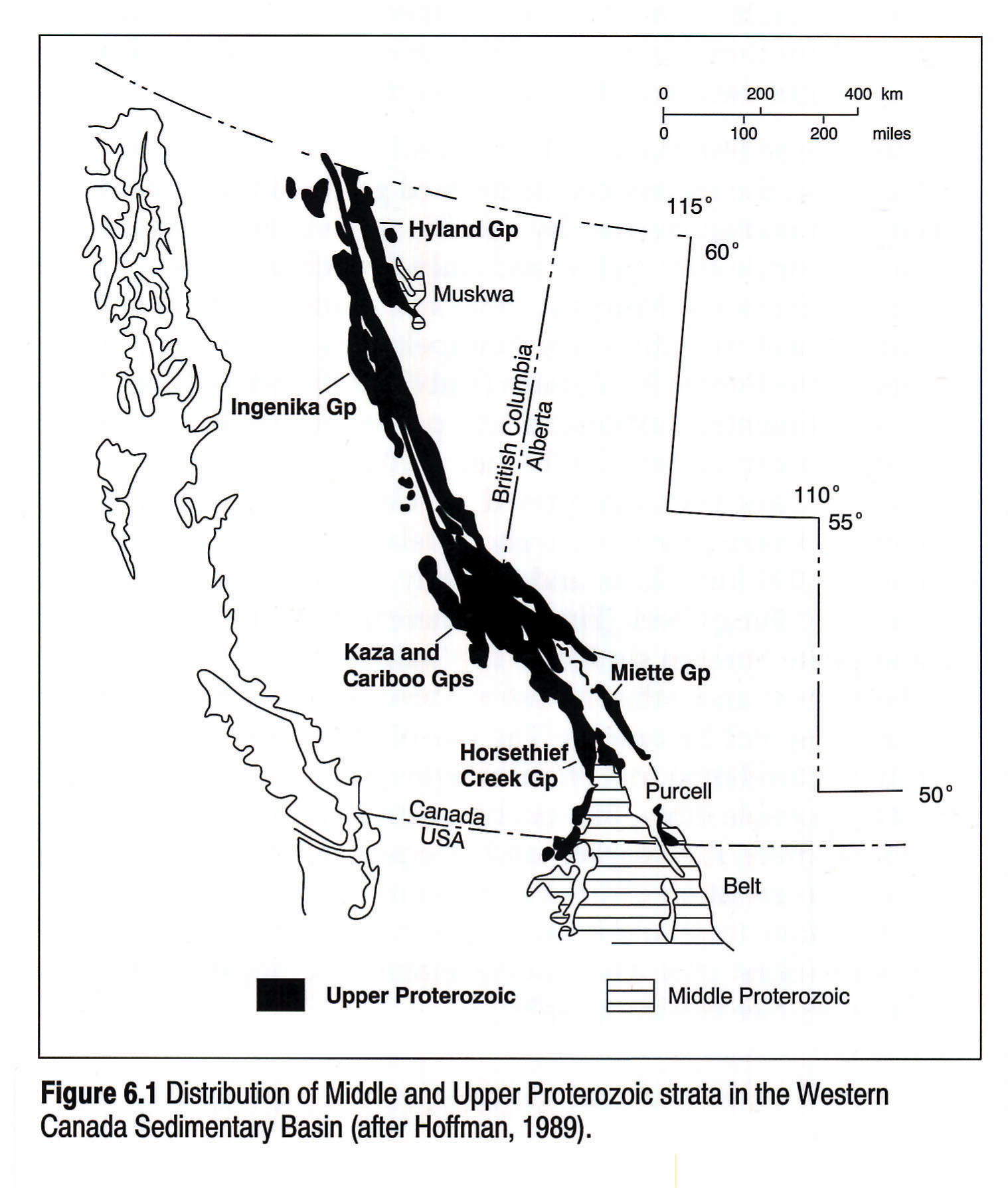
Proterozoic to Lower Cambrian strata of the Western Canada Sedimentary Basin are exposed within the Canadian Cordillera (Fig. 6.1). All exposures have been transported northeastward from their original site of deposition by structures that formed during Late Jurassic to Eocene deformation of the eastern Canadian Cordillera. This chapter deals with three major unconformity-bounded successions: Middle Proterozoic (~1.5 - 1.2 Ga), Upper Proterozoic (~0.78 - 0.54 Ga) and Lower Cambrian (0.54 - 0.53 Ga). Each succession is dominated by clastic strata and is notable for great thicknesses: up to 11 km for the Middle Proterozoic, 9 km for the Upper Proterozoic, and 4 km for the Lower Cambrian. Upper Proterozoic and Lower Cambrian strata form part of a narrow, sinuous belt of correlative rocks that extend for over 4000 km, from Alaska to northern Mexico (Stewart, 1972). Underlying Middle Proterozoic strata lack this longitudinal continuity (Fig. 6.1). These successions record multiple extension events in the early history of the western margin of the North American craton and the Western Canada Sedimentary Basin. In this chapter each succession (Middle Proterozoic, Upper Proterozoic, Lower Cambrian) are discussed separately.
Middle Proterozoic
Introduction
Two Middle Proterozoic assemblages are recognized - the Purcell (Belt) Supergroup in southeastern British Columbia and southwestern Alberta, and the Muskwa assemblage in northeastern British Columbia (Fig. 6.1). Both assemblages were deposited some time within an 800 million year interval bracketed by the age of the unconformably underlying Proterozoic crystalline basement (1.57-1.78 Ga) and the unconformably overlying Upper Proterozoic Windermere Supergroup (0.73-0.77 Ga). Each assemblage consists predominantly of fine-grained clastic and carbonate rocks that form successions several kilometres thick. The Purcell Supergroup hosts one giant and numerous smaller Pb-Zn (Ag) deposits. Many thick basic sills (Moyie sills) intrude the basal part of the supergroup. U-Pb zircon dating indicates that most of these were intruded between 1.45 and 1.33 Ga (Zartman et al., 1982; Höy, 1989).
Local lithostratigraphy and sedimentology are generally well known. However, the paucity of reliable radiometric dates and the absence of biostratigraphic control has hindered correlation within and between the assemblages and precluded accurate dating of each assemblage. Interpretation of geological, geochronological and paleomagnetic data suggests Belt-Purcell sedimentation occurred between 1.5 and 1.2 Ga (cf. McMechan and Price, 1982a), although not all workers agree. The isotopically undated Muskwa assemblage has been correlated with the Purcell (Bell, 1968) or Mackenzie Mountains (0.8-1.2 Ga; Eisbacher in Hoffman, 1989) supergroups.
In this chapter we focus on eastern and central exposures of the Purcell Supergroup. Information on northern and western assemblages, where the sediments are commonly intensely deformed, can be obtained from the references cited below.
Previous Work
Recent summaries of the lithologies, ages and tectonic settings of the Purcell and Muskwa assemblages are included in Ross et al. (1989) and Aitken and McMechan (in press). These include recent stratigraphic descriptions and assignments from western exposures of Purcell strata suggested by Reesor (1984, pers. comm.). Numerous workers have examined the Purcell Supergroup in the course of bedrock mapping and mineral exploration studies. Important regional stratigraphic and tectonic syntheses are presented in McMechan (1981) and Price (1964). Höy (1982) and Morton et al. (1973) summarized the main mineral deposit types and occurrences. Details of the giant Sullivan Pb-Zn (Ag) mine are described in Hamilton et al. (1982). Bell (1966, 1968) is the only geologist to have published significant information on the Muskwa assemblage.
Geological Framework
Two different interpretations of the tectonic setting of the Belt-Purcell Basin have been proposed. Canadian geologists have generally suggested a subsiding delta environment in a continental- margin setting (Walker, 1926; Reesor, 1957; Price, 1964) with the succession representing the initiation and formation of a passive margin (McMechan, 1981). Recently, increasing evidence for a west side to the Belt-Purcell Basin in the United States (e.g., Finch and Baldwin, 1984; Winston et al., 1984) has led to the reconsideration of an intracratonic basin setting (e.g., Winston et al., 1984), an idea initially proposed by Walcott (1910) and then abandoned. Chemical trends from Moyie Sills exposed in the southern Purcell Mountains are typical of basic volcanism in an incipient rift environment, or the early stages of continental rifting (Höy, 1989).
The quartzite and carbonate strata forming the lower part of the Muskwa assemblage were derived from the northeast and deposited on a shallow-water shelf. The deeper-water slates that make up the upper part were transported to the northwest, possibly along the axes of linear troughs developed parallel to the margin of the craton (Bell, 1968).
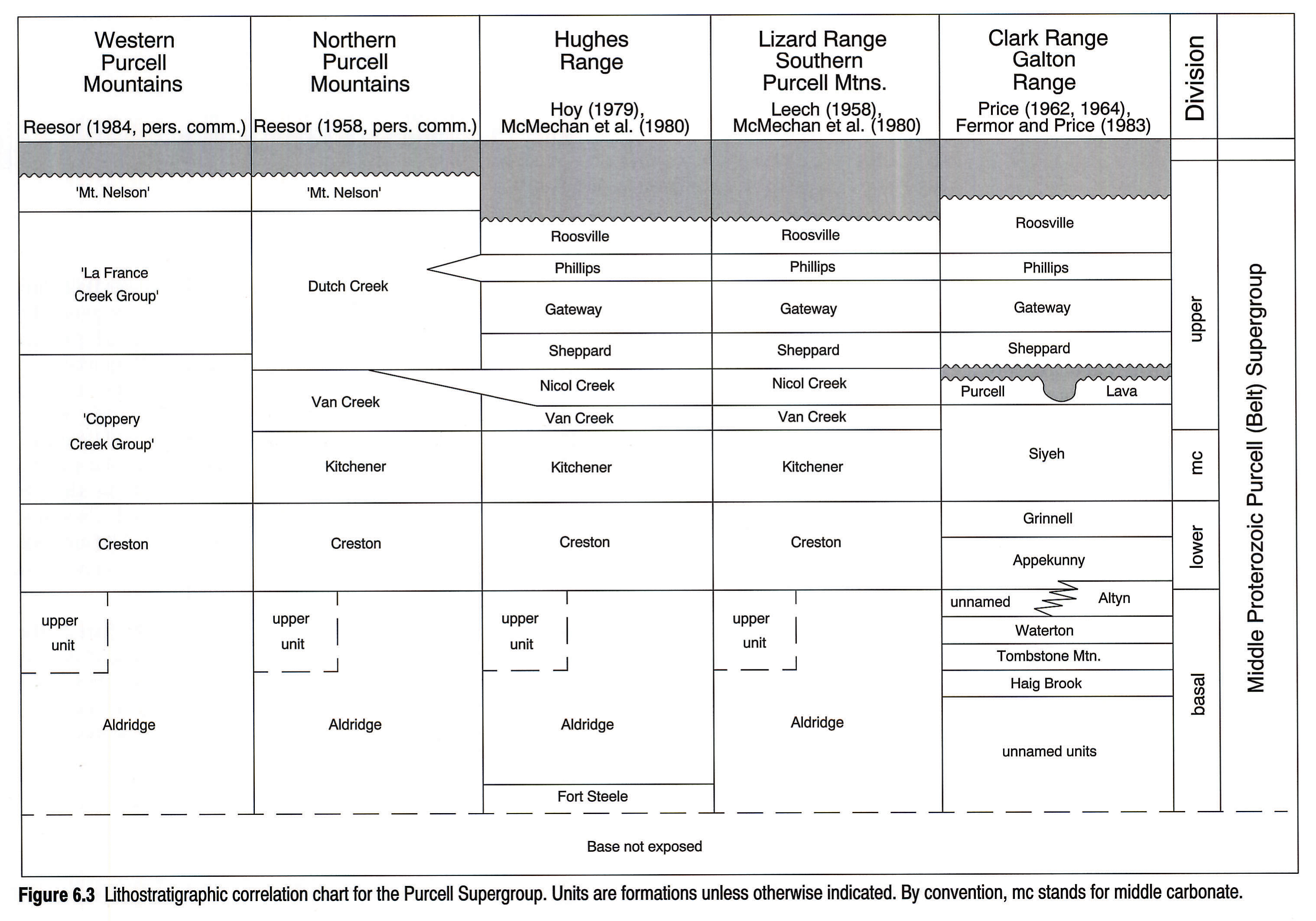
Stratigraphic Nomenclature
Exposure of Muskwa assemblage formations is limited areally. The nomenclature and general lithologies of this assemblage are summarized in Figure 6.2 .
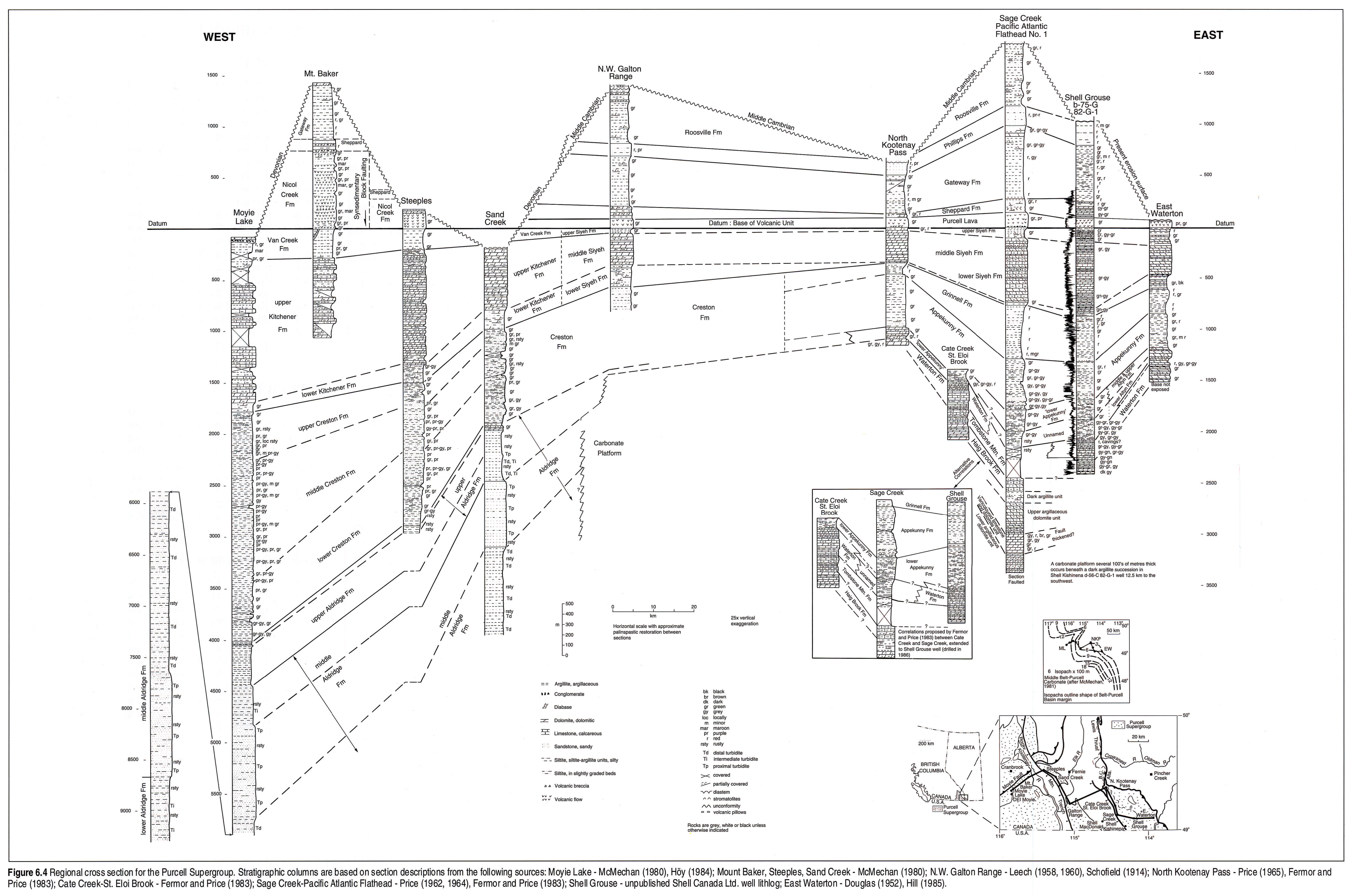
A volcanic unit (Nicol Creek Formation, Purcell Lava) forms the only chronostratigraphic marker within the Purcell Supergroup and is the main tie line of the correlation chart (Fig. 6.3). Because of the lack of biostratigraphy and paucity of geochronological control, intrabasinal correlation of other units is based strictly on lithostratigraphic correlation of homologous strata. This can result in the correlation of facies that are not exact correlatives in time. In addition, alternative lithostratigraphic correlations may be possible for some parts of the succession. The cross section of Figure 6.4 contains an example of this for the lower part of the succession between Cate Creek- St. Eloi Brook, Sage Creek and Shell Grouse. The favoured correlation, shown on the correlation chart, has the lower Altyn, Waterton and Tombstone Mountain formations changing basinward into the upper unit of the Aldridge Formation. In the alternative correlation (inset, Fig. 6.4), only the Tombstone Mountain Formation changes facies into the upper unit of the Aldridge Formation.
Stratigraphic History
The thick, fine-grained clastic- and carbonate-dominated succession forming the Purcell Supergroup can be divided into four broad divisions (basal, lower, middle carbonate and upper) on the bases of distinctive rock types and readily correlatable sequences (Fig. 6.5; McMechan, 1981). Variations in thickness and facies are most pronounced in the basal division, with a thinner, platformal, carbonate succession in the east and a thick, clastic, basinal succession in the west. Facies and thickness variations in the fine-grained clastics of the lower division reflect the embayed configuration of the basin margin and the interplay between sources of detritus to the east and south. The middle carbonate division is in a thin, platformal facies along the northeastern limit of exposure and a thicker, more basinal facies elsewhere. The upper division represents a variety of subaerial and shallow-water environments (Fig. 6.5). The only widespread disconformity recognized within the Purcell succession occurs within the upper division at the base of the Sheppard Formation. However, if Phanerozoic successions serve as an analogue for Middle Proterozoic strata, there surely must be many unrecognized disconformities within the Purcell Supergroup. Important lithological changes in the upper part of the upper division occur near the western and northern limits, rather than near the northeastern limit of exposure as in the underlying units. These changes (summarized in Aitken and McMechan, in press) may reflect the influence of source areas to the west (Root, 1987).
Regional Cross Section
The regional cross section (Fig. 6.4) clearly illustrates the great thickening of the Purcell Supergroup away from its eastern margin and its predominantly fine-grained clastic and carbonate composition. Rocks of the Purcell Supergroup are generally brightly colored. The obvious change in the basal division from platformal carbonates near the basin margin to basinal turbidites and argillites contrasts with the subtle lithological changes in overlying divisions. The section is oriented across the rectilinear basin margin (see inset Fig. 6.4). The Sage Creek-Pacific Atlantic Flathead section represents a more basinal locale than the adjacent sections and forms the key section for correlation of basal division platformal and basinal facies (see McMechan, 1981; Fermor and Price, 1983, for details). Two different lithostratigraphic correlations proposed for this important section are illustrated.
The great variation in the stratigraphic position of the overlying sub-Middle Cambrian or sub-Devonian unconformity is largely a function of the northwestward uplift of the lower Paleozoic (Montania) high (Norris and Price, 1966), complicated by pre-Devonian block faulting near its crest, which apparently reactivated fault structures formed during extrusion of the Purcell volcanics (McMechan and Price, 1982b). The upper Purcell synsedimentary block faulting occurred between the Mount Baker and Steeples sections (Fig. 6.4).
Reference Logs
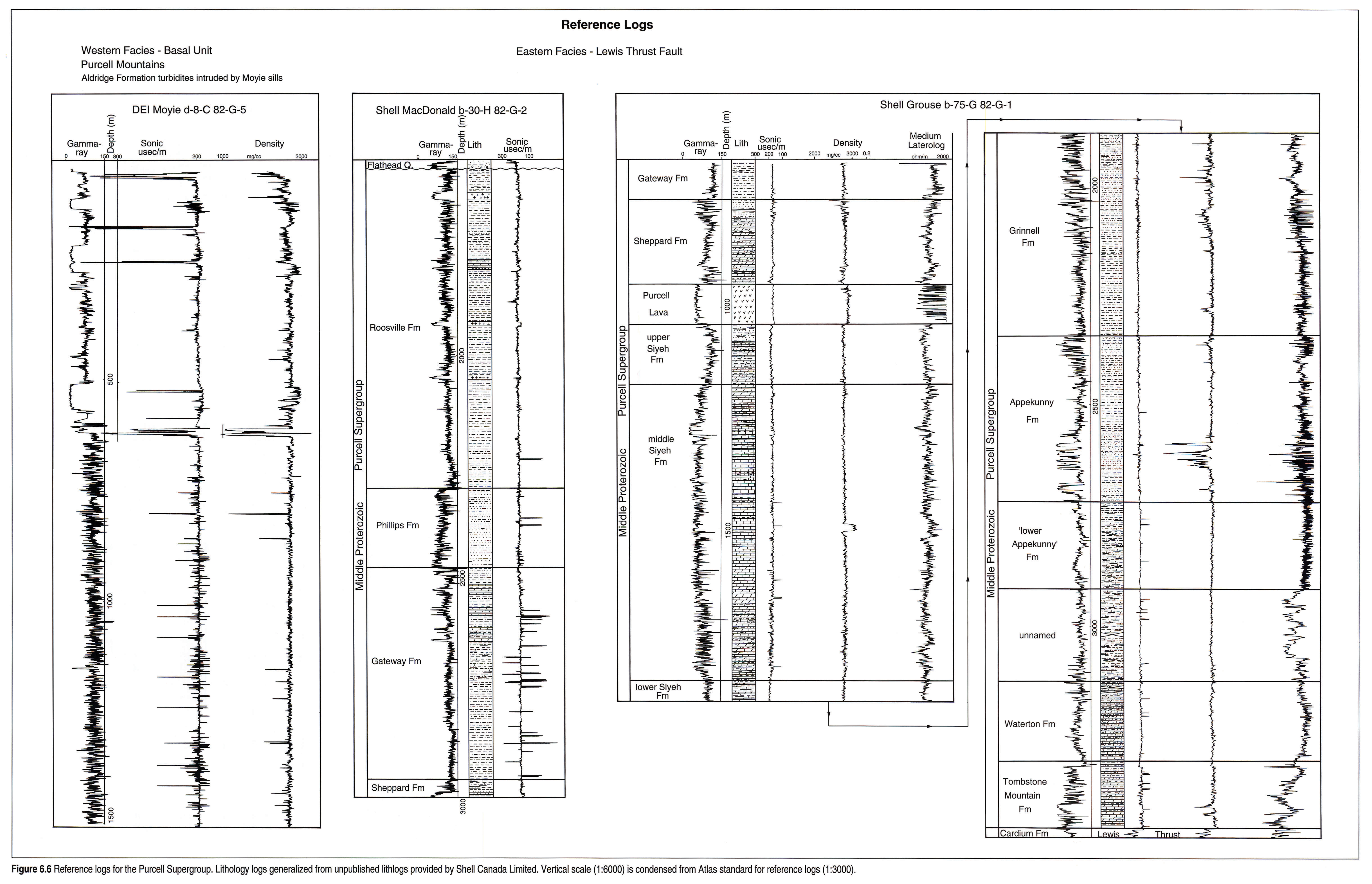
Petroleum exploration wells drilled in the 1980s provide excellent reference logs for the eastern facies and the western, basal turbidite facies of the Purcell Supergroup (Fig. 6.6). Thick mafic sills intruded into the turbidite succession are clearly recognized in the DEI Moyie well by their blocky, low gamma-ray response. The relatively high conductivities found in the unnamed and Tombstone Mountain formations in the Shell Grouse well may be due to the presence of graphitic layers such as those that occur in equivalent strata exposed nearby.
Structure and Thickness
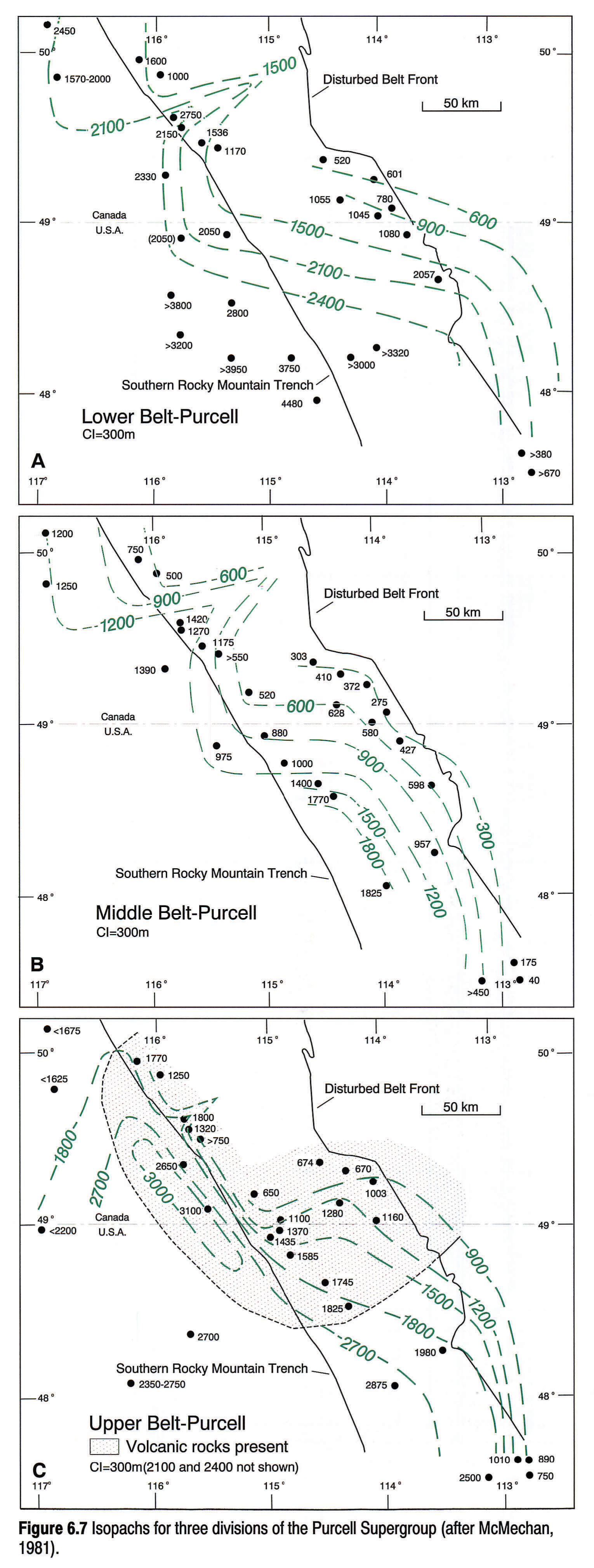
The present structure of the Purcell Supergroup reflects its distribution on thrust sheets of the Rocky Mountain Thrust and Fold Belt. In Canada, all sections have been transported over 100 km northeastward from their site of deposition. Thickness variations in the lower and also the middle carbonate division of the Purcell outline a rectilinear basin margin with a prominent northeast-trending re-entrant near the northwest corner of the isopach map (Fig. 6.7a,b). The almost 200 km east-west jog in the shape of the basin margin is mirrored by the northeastern limit of Purcell exposure, suggesting that the thrust faults carrying Purcell strata step upsection near the margin of the basin. The pattern of thickness variation for the upper division (excluding the Roosville Formation) is different from that of the underlying divisions. These changes suggest a reorganization of the basin. This reorganization was associated with extrusion of volcanic rocks and the development of a fault-controlled sub-basin (Fig. 6.7; McMechan, 1981). The northeast-trending re-entrant, apparent on all isopach maps, is a graben structure that formed during Middle Proterozoic extension (McMechan, 1981). It appears to be the western extension of a buried, graben-like structure in the basement of southern Alberta (Kanasewich et al., 1969).
Upper Proterozoic
Introduction
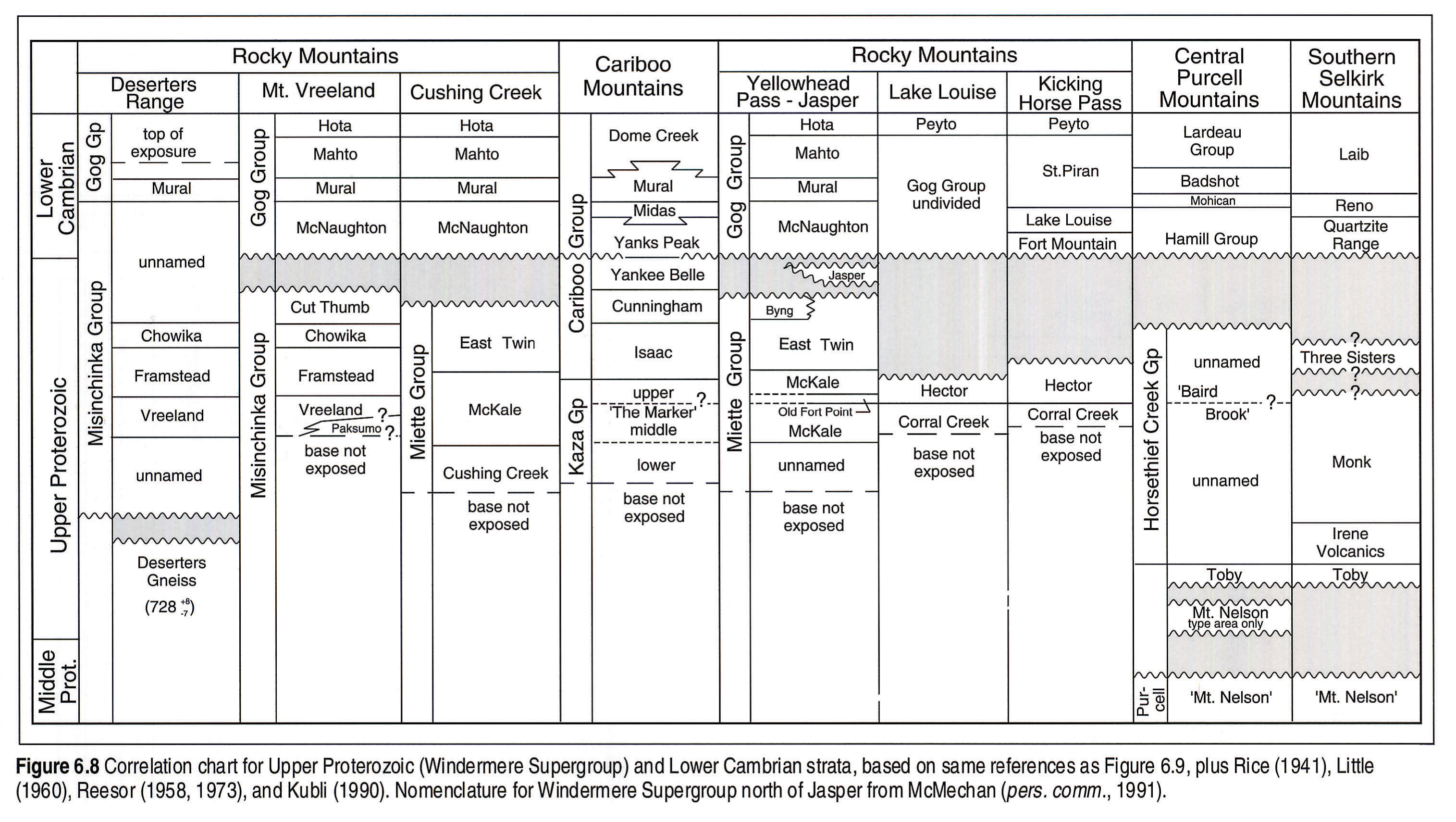
Within the Upper Proterozoic Windermere Supergroup it is not yet possible to correlate individual beds or events on a basin-wide scale, with the possible exception of 'the marker', which is discussed below. In the southern Canadian Cordillera, strata of the Windermere Supergroup unconformably overlie the Middle Proterozoic Purcell Supergroup in the central Purcell and southern Selkirk mountains, and nonconformably overlie the Deserters gneiss (728 + 8, -7 Ma; Evenchick et al., 1984) in the Deserters Range, and Malton and associated gneisses south of Valemont, B.C. (Murphy, 1990); elsewhere the base of the Upper Proterozoic is not exposed (Fig. 6.8). The Windermere Supergroup consists predominantly of coarse-grained, feldspathic conglomerate and pebbly sandstone ('grits') and pelitic shale, and less common carbonates. These strata were deposited some time within a 210 to 230 million year interval bracketed by the age of the basal Windermere Supergroup (730-770 Ma, Evenchick et al., 1984; Devlin et al., 1988) and the overlying Lower Cambrian Gog Group (540 Ma). Isolated studies have established the local stratigraphy and lithostrati- graphic correlations; however, the lack of biostratigraphic markers and the paucity of good radiometric age determinations have hampered detailed time-stratigraphic correlations within and between the various assemblages. In this chapter we focus on exposures of the Windermere Supergroup south of 57°N.
Previous Work
Detailed structural, stratigraphic and sedimentological studies have been conducted locally in areas of the southern Canadian Cordillera. Recent preliminary syntheses of the lithologies, age and tectonic setting of the Windermere Supergroup are given in Ross et al. (1989), Aitken (1990), Aitken and McDonough (1990), and Campbell and Gabrielse (in press). Bond and Kominz (1984) discuss a possible tectonic evolution and subsidence history for the Upper Proterozoic and the overlying lower Paleozoic succession of the Canadian Cordillera.
Geological Framework
In the southern Canadian Cordillera, most of the Windermere Supergroup comprises deep-water (below wave base) mass-flow deposits emplaced as part of a rift-margin and/or continental- margin succession. Locally, glaciation strongly influenced sedimentary facies and sequence patterns at the base of the succession in the south and in the middle part of the Windermere succession between 54° and 57°N. By contrast, concurrent with glaciation in the adjacent highlands, equivalent strata in eastern and central Idaho were deposited in deep to shallow water in an active volcanic rift-basin (Link, 1983; Elston et al., in press).
The top of the Windermere generally is eroded. In parts of the southern Rocky Mountains, 2 to 3 km of strata are bevelled beneath the sub-Lower Cambrian unconformity (Aitken, 1969; Simony and Aitken, 1990). Deposition was locally affected by small- and large-scale basin structures. Large-basin structures include the'Windermere High', a northwest-trending offshore high that developed south of 53°N, and which extended southeastward to the more prominent 'Montania' high.
There are many problems concerning the geological framework of the Windermere Supergroup (see Simony and Aitken, 1990). The issues include: 1) the involvement of rifting; 2) structural controls on sedimentation; 3) intra-Windermere correlation; 4) the emplacement of thick and extensive deep-water, coarse-grained feldspathic "grits" with little or no apparent facies changes; 5) the source of carbonate detritus (the "vanished" carbonate platforms); and 6) the role of glaciation both in sedimentation and as a possible control on eustatic sea-level variation. The coarser grained lower parts of the Windermere Supergroup have been interpreted as having been deposited either within a single rift basin or in a complex of rift basins (e.g., Stewart, 1972). This was followed by development of a passive margin, resulting in the deposition of the upper, finer grained, more uniform continental succession (Gabrielse, 1972). The timing of the rifting events and their relation to the subsequent breakup and drift of the margins of the proto-Pacific ocean remain controversial (Thompson et al., 1987; Devlin et al., 1988; Gabrielse, 1972; Stewart, 1976; among others).
Stratigraphic Nomenclature
A number of different stratigraphic names have been applied to the various units within the Windermere Supergroup (Fig. 6.8). Some of these formations most likely are time-correlative but the exact details of the correlations are uncertain and controversial.
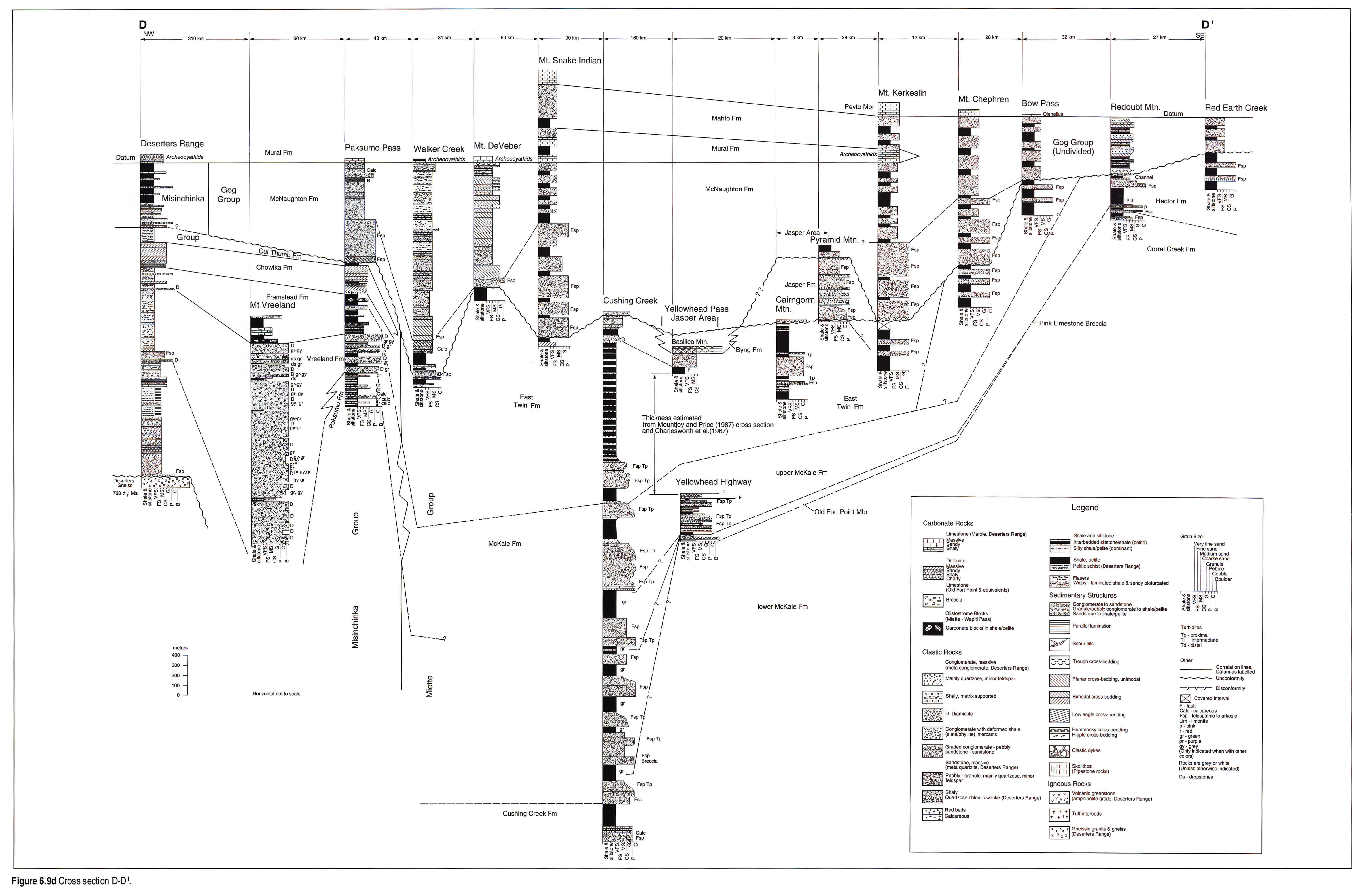
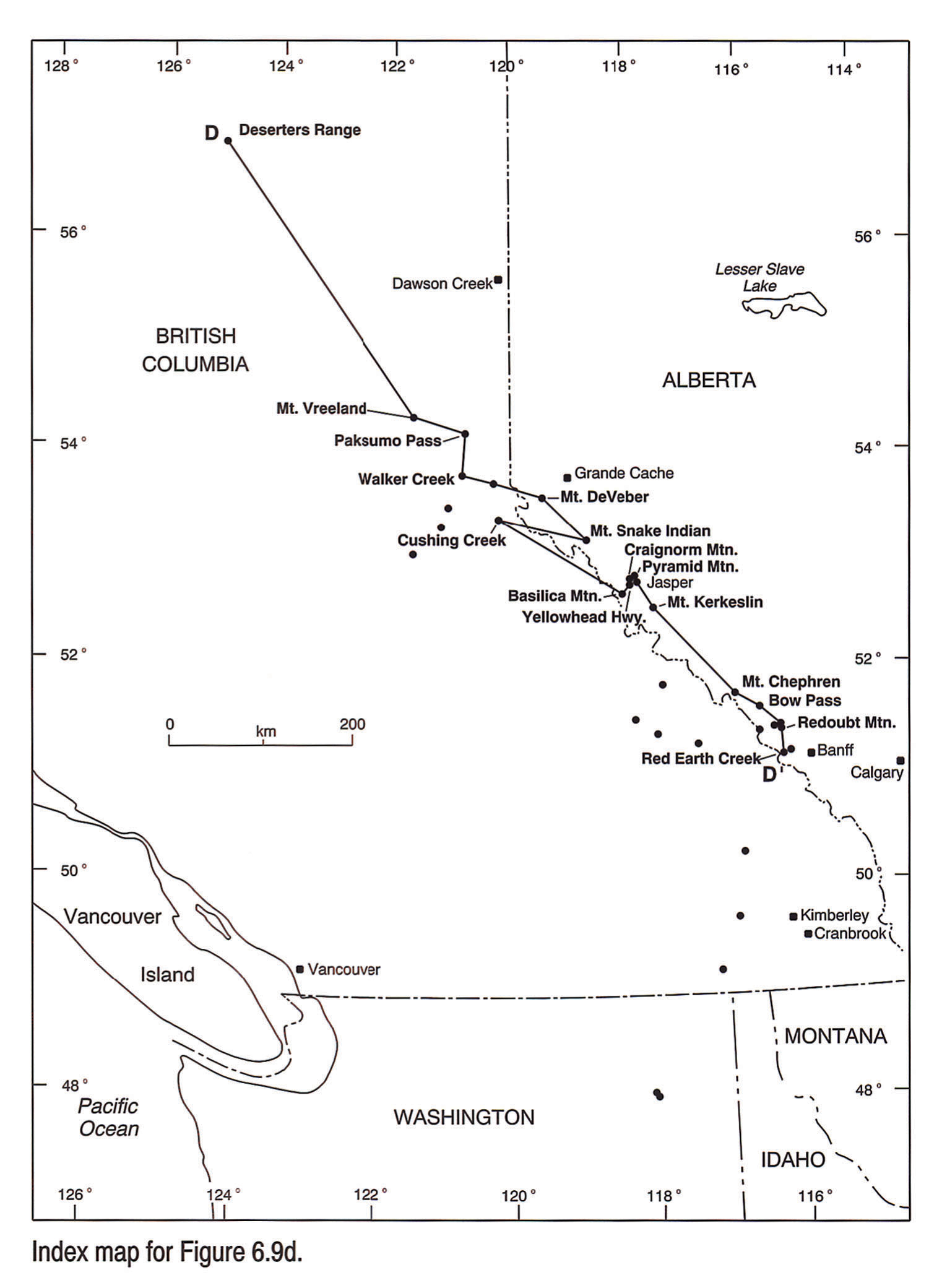
A distinctive sedimentary unit, informally known as'the marker', occurs within the mainly coarse-grained grits of the Windermere. This marker is characterized by a pelitic succession, dominated by rhythmic marble-silty pelite and sulfidic pelite in the Cariboo Mountains (Ross and Murphy, 1988) and is interpreted as correlative with distal turbidites and hemipelagites in the Baird Brook division of the Purcell Mountains (Kubli, 1990) and with the deep-water resedimented carbonates and pelites in the Old Fort Point Formation, near Jasper (Dechesne, 1990). The'marker' and its equivalents have been interpreted as relative sea-level highstand deposits and have been tentatively correlated on a basin-wide scale for over 35 000 km2 (Ross and Murphy, 1988). In some sections, such as at Cushing Creek (Fig. 6.9d, 6.9d map), there is more than one carbonate and pelite horizon similar to the'marker', suggesting that the Old Fort Point and other limestone breccias correlated with the'marker' may not be unique. The use of the'marker' as a basin-wide time-correlation tool remains equivocal, but with the lack of any other suitable litho-, bio- or chronostratigraphic datum within the Windermere, the'marker' and its equivalents are used as a tie line in the correlation chart (Fig. 6.8) and the regional cross sections. Primitive trace and body fossils in the East Twin, Isaac and Byng formations may assist in correlating the upper part of the Windermere (see biostratigraphy).
Stratigraphic History and Regional Cross Sections
The Mount Nelson Formation (Fig. 6.8) in its type section, west of Invermere, British Columbia, is interpreted by Root (1987) to be the basal unit of the Windermere Supergroup. Here the Mount Nelson consists mainly of shallow-water dolostone, sandstone, siltstone, and argillite. At the type section of the Mount Nelson Formation, there are local occurrences of'Toby-like' diamicton included within the Mount Nelson, and of 'Mount Nelson-like' dolostone within the Toby Formation, suggesting that the Mount Nelson and the Toby are somehow genetically related (Root, 1987). Elsewhere, units mapped as the'Mount Nelson Formation' probably are older strata belonging to the uppermost Purcell Supergroup (Reesor, 1984). The type-area Mount Nelson records the earliest stages of subsidence associated with the initial Windermere extension (Root, 1987).
The Toby Formation (Fig. 6.8) unconformably overlies the type-area Mount Nelson Formation and units of the Purcell Supergroup, ranging from the Gateway, Dutch Creek to'Mount Nelson' formations. Up to 2.3 km of section have been eroded beneath the sub-Toby unconformity (Root, 1987). The Toby Formation typically comprises massive, matrix-supported diamictite, consisting of sand- to boulder-size clasts set in an argillite matrix. Clast and matrix composition varies widely, depending upon the composition of the tilted fault blocks that provided the source material (see Aalto, 1971; Root, 1987). The rare occurrence of striated clasts, dropstone structures and "exotic" granitic clasts suggests that the Toby successions are, in part, glacial or glaciomarine in origin (Aalto, 1971). Recent sedimentological studies show that part of the succession may have originated as subaqueous debris flows at the base of tilted fault blocks, and that part of the succession was affected by syndepositional faulting (Root, 1987). Basic volcanics (Irene, Fig. 6.8) locally overlie the Toby in the southern Selkirk Mountains (Rice, 1941; Little, 1960).
The next succeeding units within the Windermere, comprising much of the Horsethief Creek, Miette and Kaza groups, consist predominantly of coarse-grained, feldspathic, pebbly sandstone and conglomerate ('grit'), which alternate with thick, varicoloured argillites (Fig. 6.9d, 6.9d map). The argillites locally contain thin interbeds of siltstone and fine-grained sandstone, many of which show Bouma sequences typical of deep-water turbidites. Less commonly, other argillites have siltstone and fine-grained sandstone interbeds that may represent bottom current or contourite deposits (Ross, pers. comm. 1990; Kubli, pers. comm., 1990). Local studies show that some of the grits occurred as submarine channels on small, tilted fault blocks (Arnott and Hein, 1986), or as larger submarine-channel complexes that flowed between fault blocks (McDonough, 1989). Locally, finer grained strata (argillite and deep-water limestone, Cushing Creek Formation) are exposed beneath the main grit-bearing units in central exposures (Fig. 6.9d, 6.9d map).
The grits are most notable for their uniform character along depositional strike and lack of obvious, well-defined vertical facies patterns. One interpretation is that they represent "midfan submarine fan facies" (Carey and Simony, 1985; Ross et al., 1989; among others). A problem with this interpretation is accounting for midfan facies occurring in apparently continuous zones for over 700 km along strike, and 400 km across strike (Simony and Aitken, 1990). Some of the channel fills show northwest trends parallel to the northwest depositional strike (McDonough, 1989); whereas other channel fills have north to northeast transport directions perpendicular to the strike of the paleoslope (Arnott and Hein, 1986). An alternative interpretation is that the grits were emplaced on coalescing deep-water slope aprons along graben margins (cf. Hein, 1989, for examples).
In the central Rocky Mountains, a thick succession of diamictite (Vreeland Formation, Fig. 6.9d, 6.9d map) occurs in a stratigraphic interval equivalent to the lower part of the middle Miette McKale Formation. This diamictite includes a large proportion of plutonic and volcanic boulders, derived from crystalline basement, set in an argillaceous matrix (Ross et al., 1989). Diamictites of the Vreeland Formation are underlain by siltstone, argillite, calcareous siltstone and rare grit of the Paksumo Formation in exposures near Paksumo Pass, and by an unnamed succession of quartzose chloritic wacke, quartzite, pelite, amphibolite (may be younger intrusives) and minor limestone in the Deserter's Range (Fig. 6.8b). From Mt. Vreeland the diamictite abruptly changes facies into grits and argillites of the lower part of the McKale Formation near 54°N (McMechan, 1990). Because the Vreeland diamictite occurs well above the base of the Windermere succession, where it nonconformably overlies 728 Ma gneiss, it is younger than the approximately 770 Ma diamictites found at the base of the Windermere succession in the Mackenzie Mountains (Rapitan Group) and probably younger than the basal Toby diamictite found to the south. The Vreeland diamictite has dropstone structures and represents glaciogenic sedimentation. This glaciation would correlate with the younger glacial interval (Ice Brook Formation) recognized by Aitken (1988, 1989a, 1991) in the Mackenzie Mountains (McMechan, 1990).
The Vreeland diamictite is abruptly overlain by either a thin banded limestone or fine-grained clastics. Large blocks of platformal carbonate (olistostromes) occur within dark argillites of the lower Framstead Formation immediately above the diamictite (Fig. 6.9d, 6.9d map, north end). Locally, deep-water limestone occurs within the argillite sequence. A westward-thickening grit unit occurs within the argillites beneath the shallow-marine carbonates of the Chowika Formation. These grits are traceable into grits forming the top of the McKale Formation (Fig. 6.9d, 6.9d map, Paksumo Pass to Cushing Creek; McMechan, 1990). The Chowika carbonate platform shales out to the west and south into the East Twin Formation.
The upper Miette Group (East Twin and Byng formations) primarily consists of argillites, with thinner units of sandstone. Locally, the argillites coarsen-and shallow-upward into platform carbonates. These platform carbonates occur in the Jasper area (e.g., Basilica Mountain, Fig. 6.9d, 6.9d map) and are disconformably overlain by the Gog Group. Poulton (1973) described a similar 200 m thick stromatolitic carbonate bank disconformably overlain by the Lower Cambrian Hamill Group in the Rogers Pass area. This carbonate passes westward into deep-water resedimented carbonates and clastic slope successions. In the Cariboo Mountains, carbonates of the Cunningham Formation (Figs 6.8, 6.9a, 6.9a map) are probably correlative with the Byng Formation near Jasper (Fig. 6.8). The carbonate breccias and detritus found in units of the McKale, Old Fort Point, and Isaac show that similar but older carbonate banks and platforms must have existed east of the exposed Windermere succession.
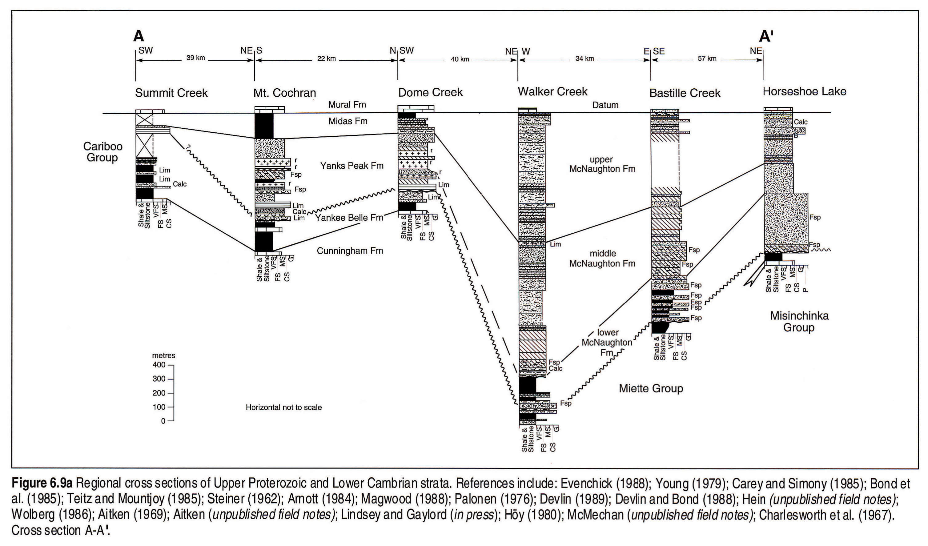
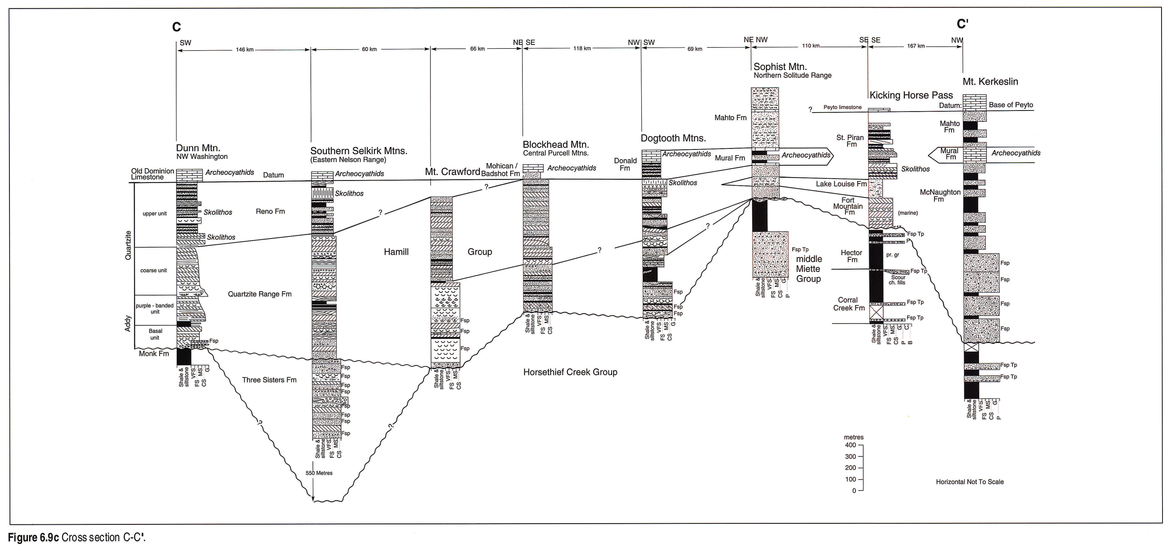
In a few areas, puzzling unconformity-bounded, coarse clastic units occur between typical upper Windermere and typical Lower Cambrian lithotypes. These include the Jasper Formation near Jasper, and the Three Sisters Formation in the southern Selkirk Mountains (Figs. 6.9c, 6.9c map, 6.9d, 6.9d map) Both consist of crossbedded, feldspathic to arkosic sandstones and conglomerates, with minor argillites and siltstones (Charlesworth et al., 1967; Little, 1960; Devlin and Bond, 1988). Both units have been interpreted as Late Proterozoic or Early Cambrian in age by various authors. On Figures 6.8 and 6.9c, 6.9c map, 6.9d, 6.9d map we interpret these units as being older than the widespread, locally feldspathic sandstones at the base of the Hamill and Gog groups. In the Cariboo Mountains, the top of the Upper Proterozoic consists of interbedded carbonates and terrigenous clastics of the Yankee Belle Formation (Fig. 6.8). This unit is probably younger than most of the upper Miette Group strata, and is disconformably or conformably overlain by the sandstone-dominated Yanks Peak Formation, which is equivalent to the basal Gog Group to the southeast.
Biostratigraphy
In the Mackenzie and Wernecke mountains, Northwest Territories, the Windermere Supergroup contains simple trace fossils and Ediacaran megafossils throughout the topmost 2.5 km of section (Narbonne and Hofmann, 1987). The first trace fossils and Ediacaran megafossils occur in the deep-water grits below a tillite, indicating that significant colonization of the deep seafloor began in the Late Precambrian and may relate to waning glaciation (Aitken, 1989a). Ediacaran-bearing limestones also occur near Jasper (Byng Formation, Fig. 6.9d, 6.9d map; Hofmann et al., 1985) and medusoid forms resembling the Ediacaran fossils have been reported from the upper Isaac Formation in the Cariboo Mountains (Ferguson and Simony, 1991). Diversity and complexity of trace fossils increases upward toward the Precambrian/Cambrian boundary, commonly marked by the abrupt occurrence of complex two- and three-dimensional forms in the Cambrian (Narbonne et al., 1987). Preliminary biostratigraphic zones appear to be correlative across North America (Narbonne et al., 1987), and as such they may provide a correlation tool for the uppermost Windermere strata and aid in the distinction of the Precambrian-Cambrian boundary.
Lower Cambrian
Introduction
In the southern Canadian Cordillera, the lower Paleozoic successions, including the Gog, upper Cariboo, Hamill and lower Lardeau groups (Fig. 6.8), are notable for their striking similarity along tectonic strike. A number of units are very widespread and can be used for long-distance correlation (Fig. 6.8). The base of the Gog Group is most likely Early Cambrian (570 Ma) and this unit and the correlative Hamill Group unconformably or disconformably overlie the Upper Proterozoic Windermere Supergroup. Sediments are predominantly sandstones deposited on a rapidly subsiding continental margin at a time marked by a worldwide transgression (Vail et al., 1977). The Peyto Limestone Member and Hota Formation at the top of the Gog Group contain very late Early Cambrian Ollenellus (trilobite) fauna. Thus, the age range for the Gog Group is Early Cambrian to very late Early Cambrian. In the southern Canadian Cordillera, the top of the Gog Group is bevelled by the sub-Middle Cambrian unconformity (Aitken, 1989b). East of the Rockies in the Alberta Basin the relationship of the Gog quartzite to the Basal Sandstone is uncertain; however, most workers consider the Basal Sandstone to be the temporal equivalent of the Middle Cambrian Mount Whyte Formation of the Rockies (Aitken, 1968; Pugh, 1975).
Previous Work
In the southern Canadian Cordillera, detailed structural, stratigraphic and sedimentological studies have been conducted in local study areas, but regional studies are lacking for the Gog Group. Recent preliminary syntheses of the lithologies, age and tectonic setting of the Gog Group are given by Aitken (1989b) and Campbell and Gabrielse (in press b). Bond and Kominz (1984) modelled the subsidence history of these lower Paleozoic successions. Devlin and Bond (1988) discussed regional correlations of the Lower Hamill Group in southeastern British Columbia.
Geological Framework
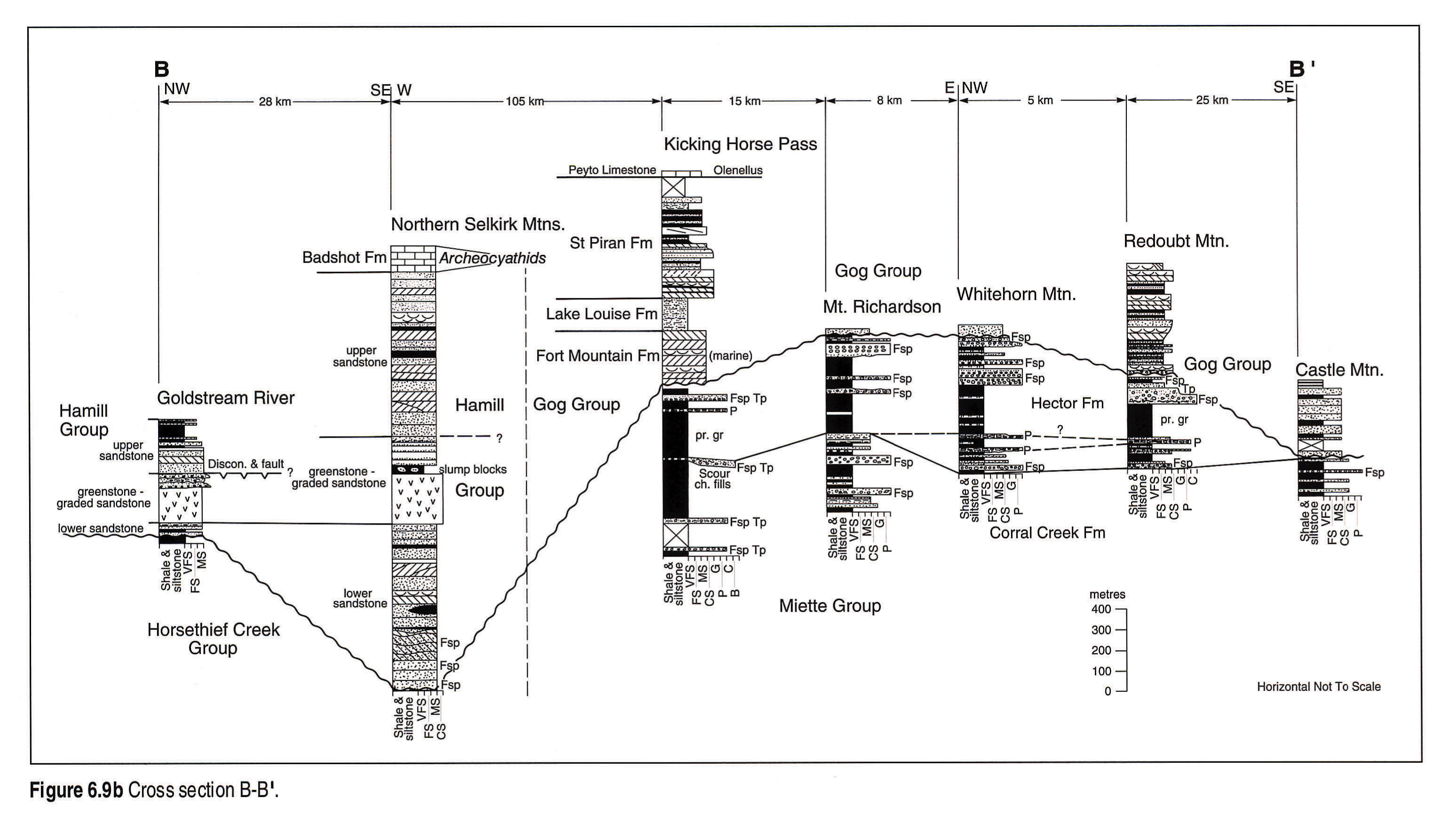
The style of sedimentation indicates that most of the Gog and Hamill groups was deposited along a stable passive continental margin. Local structural controls included the influence of Montania and the Windermere High in the southeast and the McBride Arch, with the inboard Robson Trough, to the northwest (Young, 1979). Subsidence analysis led Bond and Kominz (1984) to conclude that the thermal subsidence of the lower Paleozoic passive margin was initiated by a latest Proterozoic or earliest Cambrian rifting event. Greenstones interbedded with deep-water mass-flow deposits in the northern Selkirk Mountains (Fig. 6.9b, 6.9b map) are considered direct evidence for an episode of extensional tectonism during the earliest Cambrian (Devlin, 1989).
Stratigraphic Nomenclature
A number of formations are recognized within the Lower Cambrian succession of the southern Canadian Cordillera. Many of these formations are very uniform throughout the area, although in general, they become more shaly toward the west. Because of the fairly uniform nature of most of the units, correlations are more certain than in the underlying Windermere, and are summarized in Figure 6.8. Two sedimentary units are used as datums. These are the base of the archeocyathid-bearing Mural Formation, and the base of the Ollenellus-bearing Peyto Member/Hota Formation (Figs. 6.8, 6.9). The Mural correlates regionally with the archeocyathid- bearing limestones of the Donald, Mohican/Badshot formations of the Dogtooth and Purcell mountains, and with the Old Dominion Limestone of northwestern Washington (Fig. 6.9b, 6.9b map, 6.9c, 6.9c map).
Stratigraphic History and Regional Cross Sections
Initial deposits of the Lower Cambrian are feldspathic, poorly sorted, conglomeratic or pebbly sandstones. In the basal McNaughton, very thick successions of massive conglomerate were emplaced by fan deltas and possibly braided rivers in the central Rocky Mountains (Fig. 6.9a, 6.9a map; Young, 1979). Farther south, feldspathic conglomerates are generally absent. Devlin and Bond (1988) interpreted the Three Sisters Formation as an Early Cambrian fluvial succession, which may be equivalent to the basal McNaughton. However, we have followed the pre-Hamill Group interpretation of Little (1960) on our regional cross section (Fig. 6.9c, 6.9c map). In the northern Selkirk Mountains, the lower sandstone within the Hamill Group (Fig. 6.9b, 6.9b map) is unchannelled and uniform along strike, and has features indicating a shallow-marine origin (Devlin, 1989). The next unit in this area is a greenstone and graded sandstone unit, which is interpreted as representing a period of volcanism, creation of a deep-water paleoslope or fault scarp, and the emplacement of large volumes of submarine mass flows along the base-of-slope. Sedimentation is interpreted to have been strongly influenced by syndepositional faulting. With waning tectonic activity and filling of the fault basin, shallow-marine deposition returned and the upper sandstone unit resulted (Fig. 6.9b, 6.9b map). Finally, as clastic supply dwindled, carbonate sedimentation associated with a possible transgression ensued, resulting in deposition of the Badshot limestone (Fig. 6.9c, 6.9c map).
Lateral equivalents to the upper sandstone in the northern Selkirks are very well exposed in the Kicking Horse Pass area, where they have been studied in detail (Hein, 1987; Hein et al., in press; Fig. 6.9b, 6.9b map, 6.9c, 6.9c map). Here, the tidally-dominated Fort Mountain Formation consists of quartzite and less common shale. This is succeeded by the shaly, shallow-marine Lake Louise Formation which, in turn, is overlain by shelf sandstone ridges of the St. Piran Formation. As with the clastic successions in the Selkirk Mountains, clastic supply diminished through time, with the capping limestone of the Peyto Formation completing the sequence.
To the northwest, in the central Rocky Mountains, sandstones of the lower McNaughton are shallow marine and strongly tidally influenced (Fig. 6.9a, 6.9a map). In the Robson Trough (Walker Creek and Bastille Creek, Fig. 6.9a, 6.9a map) the middle and upper McNaughton formations are shallow-marine successions. Laterally equivalent strata to the west, over the McBride Arch, are subaerial (Yanks Peak Formation; Mt. Cochran and Dome Creek, Fig. 6.9a, 6.9a map; Young, 1979). During deposition of the Midas Formation, sand supply was greatly diminished, and weak tidal currents moved material in the Robson Trough and to the west. Finally, the Robson Trough was infilled and an iron-rich, calcareous green shale, interpreted as a lateritic paleosol (Young, 1979), was deposited above the McNaughton, forming the basal unit of the Mural. Shallow-marine carbonates of the Mural Formation record a transgression. Overlying quartz sandstones of the Mahto Formation (Fig. 6.8) record two large-scale sandstone-shale successions deposited in shallow-marine to alluvial environments. The Mural Formation thins and becomes sandier to the south and east (Figs. 6.9c, 6.9c map, 6.9d, 6.9d map). Where the Mural is no longer recognized, the Mahto is not distinguished from underlying strata. Clastic supply diminished and limestones of the Hota Formation (Peyto Member) occur at the top of the group.
Biostratigraphy
The clastic successions within the Gog Group lack body fossils but contain a diverse trace fossil assemblage (Magwood, 1988). Some of the common traces documented in the Kicking Horse Pass/ Lake Louise area include: Bergaueria, Cruziana, Skolithos, Didymaulichnus, Rusophycus, Gordia, Planolites, Chondrites, Phycodes, Teichichnus and Zoophycus, plus others. Most of these forms and their abundance suggest that these traces belong to the Cruziana ichnofacies. Concentrations of Skolithos (called'pipestone rock' locally) occur in coarser grained, and higher energy deposits (Fig. 6.9c, 6.9c map). The presence of well developed Cruziana and Rusophycus within the Gog Group in the Lake Louise area indicates it is Atdabanian in age (Magwood, 1988). This is supported by the presence of the Olenellus index fossils in the Peyto Member, which also are Atdabanian in age. Elsewhere, lower Gog Group strata contain more simple traces and a less diverse ichnofacies (Young, 1979).
Acknowledgements
We would like to thank Shell Canada Limited for providing detailed lithology logs for the Shell Grouse and Shell MacDonald wells; Kevin Root and Rick Young for their careful review of the manuscript; Peter Fermor for discussions on Purcell correlations and lithotypes in the Lewis thrust sheet; and Peter Gubitz, Peter Neelands and Elizabeth Johnston for drafting of original figures.
References
- Aalto, K.R. 1971. Glacial marine sedimentation and stratigraphy of the Toby conglomerate (Upper Proterozoic), southeastern British Columbia, northwestern Idaho and northeastern Washington. Canadian Journal of Earth Sciences, v. 8, p. 753-787.
- Aitken, 1968. Cambrian sections in the easternmost southern Rocky Mountains and the adjacent subsurface, Alberta. Geological Survey of Canada, Paper 66-23.
- Aitken, J.D. 1969. Documentation of the sub-Cambrian unconformity, Rocky Mountains, Main Ranges, Alberta. Canadian Journal of Earth Sciences, v. 6, p. 193-200.
- Aitken, J.D. 1988. First appearance of trace fossils in Mackenzie Mountains, northwest Canada, in relation to the highest glacial deposits and lowest small shelly fossils. In: Trace Fossils, Small Shelly Fossils and the Precambrian-Cambrian Boundary. E. Landing, G.M. Narbonne and P. Myrow (eds.). New York State Museum Bulletin 463, p. 8.
- Aitken, J.D. 1989a. A "sea level" curve for the terminal Proterozoic, Mackenzie Mountains, N.W.T.: Progress report. Geological Association of Canada, Abstracts with Program, v. 14, p. A99.
- Aitken, J.D. 1989b. The Sauk sequence - Cambrian to Lower Ordovician miogeocline and platform. In: Western Canada Sedimentary Basin: A Case History. B.D. Ricketts (ed.). Calgary, Canadian Society of Petroleum Geologists, Chpt. 7, p. 105-119.
- Aitken, J.D. (compiler). 1990. Late Proterozoic glaciation, rifting and eustacy, as illustrated by the Windermere Supergroup. Geological Association of Canada, Nuna Research Conference, Invermere and Valemount, British Columbia, Programme with Abstracts, 51 p.
- Aitken, J.D. 1991. Two Late Proterozoic glaciations, Mackenzie Mountains, northwestern Canada. Geology, v. 19. p. 445-448.
- Aitken, J.D. and McDonough, D.M.R. (compilers) 1990. Late Proterozoic glaciation, rifting and eustacy, as illustrated by the Windermere Supergroup. Geological Association of Canada, Nuna Research Conference, Invermere and Valemount, British Columbia, Field Trip Guidebook, p. 1.1 to 10.27.
- Aitken, J.D. and McMechan, M.E. (in press). Middle Proterozoic assemblages. In: The Cordilleran Orogen: Canada. H. Gabrielse and C.J. Yorath (eds.). Geological Survey of Canada, Geology of Canada, No. 4, Ch 5. (also Geological Society of America, The Geology of North America, no. G-2).
- Arnott, R.W. 1984. Proximal channel deposits of the Hadrynian Hector Formation, Lake Louise, Alberta. Unpublished M.Sc. thesis, University of Alberta, Edmonton, 149 p.
- Arnott, R.W. and Hein, F.J. 1986. Submarine canyon fills of the Hector Formation, Lake Louise, Alberta: Late Precambrian syn-rift deposits of the proto-Pacific miogeocline. Bulletin of Canadian Petroleum Geology, v. 34, p. 395-407.
- Bell, R.T. 1966. Precambrian rocks of the Tuchodi Lakes map-area, northeastern British Columbia. Unpublished Ph.D. thesis. Princeton University, 138 p.
- Bell, R.T. 1968. Proterozoic stratigraphy of northeastern British Columbia. Geological Survey of Canada, Paper 67-68, 75 p.
- Bond, G.C. and Kominz, M.A. 1984. Construction of tectonic subsidence curves for the early Paleozoic miogeocline, southern Canadian Rocky Mountains - implications for subsidence mechanisms, age of breakup, and crustal thinning. Geological Society of America, Bulletin, v. 95, p. 155-173.
- Bond, G.C., Christie-Blick, N., Kominz, M.A., and Devlin, W.J. 1985. An Early Cambrian rift to post-rift transition in the Cordillera of western North America. Nature, v. 316, p. 742-745.
- Campbell, R.B. and Gabrielse, H. (in press). Upper Proterozoic Assemblages. In: The Cordilleran Orogen: Canada. H. Gabrielse and C.J. Yorath (eds.). Geological Survey of Canada, Geology of Canada, No. 4, Ch. 6 (also Geological Society of America, The Geology of North America, No. G-2).
- Carey, A.J. and Simony, P.S. 1985. Stratigraphy, sedimentology and structure of Late Proterozoic Miette Group, Cushing Creek area, British Columbia. Bulletin of Canadian Petroleum Geology, v. 33, p. 184-203.
- Charlesworth, H.A.K., Weiner, J.L., Akehurst, A.J., Bielenstein, H.U., Evans, C.R., Griffiths, R.E., Remington, D.B., Stauffer, M.R., and Steiner, J. 1967. Precambrian geology of the Jasper region, Alberta. Research Council of Alberta, Bulletin 23, 74 p.
- Dechesne, R. 1990. Old Fort Point Formation, Miette Group, carbonate turbidites in a terrigenous succession. In: Late Proterozoic Glaciation, Rifting and Eustacy, as Illustrated by the Windermere Supergroup. J.D. Aitken (comp.). Geological Association of Canada, Nuna Research Conference, Invermere and Valemount, British Columbia, Abstracts, p.6-7.
- Devlin, W.J. 1989. Stratigraphy and sedimentology of the Hamill Group in the northern Selkirk Mountains, British Columbia; evidence for latest Proterozoic - Early Cambrian extensional tectonism. Canadian Journal of Earth Sciences, p. 515-533.
- Devlin, W.J. and Bond, G.C. 1988. The initiation of the early Paleozoic Cordilleran miogeocline: evidence from the uppermost Proterozoic - Lower Cambrian Hamill Group of southeastern British Columbia. Canadian Journal of Earth Sciences, v. 25, p. 1-19.
- Devlin, W.J., Brueckner, H.K., and Bond, G.C. 1988. New isotopic data and a preliminary age for volcanics near the base of the Windermere Supergroup, northeastern Washington, U.S.A. Canadian Journal of Earth Sciences, v. 25, p. 1906-1911.
- Douglas, R.J.W. 1952. Waterton, Alberta. Geological Survey of Canada, Paper 52-10.
- Elston, D.P., Winston, D., and Link, P.K. (in press). Tectonic setting and correlation of some Middle and Late Proterozoic rocks of the western United States Cordillera. In: Precambrian Rocks of the Conterminous United States, Geological Society of America DNAG series.
- Evenchick, C.A. 1988. Stratigraphy, metamorphism, structure and their tectonic implications in the Sifton and Deserters ranges, Cassiar and northern Rocky Mountains, northern British Columbia. Geological Survey of Canada, Bulletin 376, 90 p.
- Evenchick, C.A., Parrish, R.R., and Gabrielse, H. 1984. Precambrian gneiss and Late Proterozoic sedimentation in north-central British Columbia. Geology, v. 12, p. 233-237.
- Ferguson, C.A. and Simony, P.S. 1991. Preliminary report on structural evolution and stratigraphic correlations, northern Cariboo Mountains, British Columbia. In: Current Research, Part A, Geological Survey of Canada, Paper 91-1A, p. 103-110.
- Fermor, P.R. and Price R.A. 1983. Stratigraphy of the lower part of the Belt-Purcell Supergroup (middle Proterozoic) in the Lewis thrust sheet of southern Alberta and British Columbia. Bulletin of Canadian Petroleum Geology, v. 31, p. 169-194.
- Finch, J.C. and Baldwin, D.D. 1984. Stratigraphy of the Prichard Formation, Belt Supergroup. In: The Belt. S.W. Hobbs (ed.). Montana Bureau of Mines and Geology, Special Publication 90, p. 5-7.
- Gabrielse, H. 1972. Younger Precambrian of the Canadian Cordillera. American Journal of Science, v. 272, p. 521-536.
- Hamilton, J.M., Bishop, D.T., Morris, H.C., and Owens, O.E. 1982. Geology of the Sullivan Orebody, Kimberley, B.C., Canada.In: Precambrian Sulphide Deposits. R.W. Hutchinson, C.D. Spence and J.M. Franklin (eds.). Geological Association of Canada, Special Paper 25, p. 597-665.
- Hein, F.J. 1987. Tidal/littoral offshore shelf deposits - Lower Cambrian Gog Group, southern Rocky Mountains, Canada. Sedimentary Geology, v. 52, p. 155-182.
- Hein, F.J. 1989. Slope aprons and slope basins. Chpt. 5. In: Deep Marine Environments - Clastic Sedimentation and Tectonics. K.T. Pickering, R.N. Hiscott and F.J. Hein, London, Unwin-Hyman, p. 91-132.
- Hein, F.J., Robb, G.A., Wolberg, A.C., and Longstaffe, F.J. 1991. Facies descriptions and associations in ancient reworked (? transgressive) shelf sandstones: Cambrian and Cretaceous examples. Sedimentology, v. 38, p. 405-431.
- Hill, R.E. 1985. Stratigraphy and sedimentology of the middle Proterozoic Waterton and Altyn formations, Belt-Purcell Supergroup, southwest Alberta. Unpublished M.Sc. thesis, McGill University, Montreal, Quebec, 165 p.
- Hoffman, P.F. 1989. Precambrian geology and tectonic history of North America. In: Geology of North America- an overview. A.W. Bally and A.R. Palmer (ed.). Geological Society of America, Decade of North American Geology, v. A, p. 447-512.
- Hofmann, H.J., Mountjoy, E.W., and Teitz, M.W. 1985. Ediacaran fossils from the Miette Group, Rocky Mountains, British Columbia, Canada. Geology, v. 13, p. 819-821.
- Höy, T. 1979. Geology of the Estella-Kootenay King area, Hughes Range, southeastern British Columbia. British Columbia Ministry of Energy, Mines and Petroleum Resources, Preliminary Map 36.
- Höy, T. 1980. Geology of the Riondel area. British Columbia Ministry of Energy, Mines and Petroleum Resources, Bulletin 73.
- Höy, T. 1982. The Purcell Supergroup in southeastern British Columbia: sedimentation, tectonic, and stratiform lead-zinc deposits. In: Precambrian sulphide deposits. R.W. Hutchinson, C.D. Spence and J.M. Franklin (eds.). H.S. Robinson Memorial Volume, Geological Association of Canada, Special Paper 25, p. 127-147.
- Höy, T. 1984. The Purcell Supergroup near the Rocky Mountain Trench, southeastern British Columbia. In: The Belt. W.S. Hobbs (ed.). Montana Bureau of Mines and Geology, Special Publication 90, p. 36-38.
- Höy, T. 1989. The age, chemistry, and tectonic setting of the Middle Proterozoic Moyie sills, Purcell Supergroup, southeastern British Columbia. Canadian Journal of Earth Sciences, v. 26, p. 2305-2317.
- Kanasewich, E.R., Flows, R.N. and McCoughan, C.H. 1969. A buried Precambrian rift in Western Canada. Tectonophysics, v. 8, p. 513-527.
- Kubli, T.E. 1990. Geology of the Dogtooth Range, northern Purcell Mountains, British Columbia. Unpublished Ph.D. thesis, University of Calgary, Alberta, 324 p.
- Leech, G.B. 1958. Fernie map-area, west half, British Columbia. Geological Survey of Canada, Paper 58-10, 40 p.
- Leech, G.B. 1960. Geology Fernie (west half) Kootenay District, British Columbia. Geological Survey of Canada, Map 11-1960.
- Lindsey, K.A. and Gaylord, D.R. (in press). Fluvial, coastal, nearshore, and shelf deposition in the Upper Proterozoic(?) to Lower Cambrian Addy Quartzite, northeastern Washington. Journal of Sedimentary Petrology. 40 p.
- Link, P.K. 1983. Glacial and tectonically influenced sedimentation in the upper Proterozoic Pocatello Formation, southeastern Idaho. In: Tectonic and stratigraphic studies in the eastern Great Basin. D.M. Miller, V.R. Todd and K.S. Howard (eds.). Geological Society of America Memoir 157, p. 165-182.
- Little, H.W. 1960. Nelson map-area, west half, British Columbia. Geological Survey of Canada, Memoir 308, 205 p.
- Magwood, J.P.A. 1988. The ichnology of the Lower Cambrian Gog Group, Lake Louise, Alberta. Unpublished M.Sc. thesis, University of Alberta, Edmonton, 306 p.
- McDonough, M.R. 1989. The structural geology and strain history of the northern Selwyn Range, Rocky Mountains, near Valemount, British Columbia. Unpublished Ph.D. thesis, University of Calgary, Alberta, 290 p.
- McMechan, M.E. 1980. Stratigraphy, structure and tectonic implications of the middle Proterozoic Purcell Supergroup in the Mount Fisher area, southeastern British Columbia. Unpublished Ph.D. thesis, Queen's University, Kingston, Ontario, 280 p.
- McMechan, M.E. 1981.The middle Proterozoic Purcell Supergroup in the southwestern Rocky and southeastern Purcell mountains, British Columbia and the initiation of the Cordilleran miogeocline, southern Canada and adjacent United States. Bulletin of Canada Petroleum Geology, v. 29, p. 583-621.
- McMechan. M.E. 1990. Upper Proterozoic to Middle Cambrian history of the Peace River Arch: evidence from the Rocky Mountains. Canadian Society of Petroleum Geologists, v. 38A, p. 36-44.
- McMechan, M.E., Höy, T., and Price, R.A. 1980. Van Creek and Nicol Creek formations (New): A revision of the stratigraphic nomenclature of the middle Proterozoic Purcell Supergroup, southeastern British Columbia. Bulletin of Canadian Petroleum Geology, v. 28, p. 542-558.
- McMechan, M.E. and Price, R.A. 1982a. Superimposed low-grade metamorphism in the Mount Fisher area, southeastern British Columbia - implications for the East Kootenay orogeny. Canadian Journal of Earth Sciences, v. 19, p. 476-489.
- McMechan, M.E. and Price, R.A. 1982b. Transverse folding and superposed deformation, Mount Fisher area, southern Canadian Rocky Mountain thrust and fold belt. Canadian Journal of Earth Sciences, v. 19, p. 1011-1024.
- Morton, R., Goble, E., and Goble, R.J. 1973. Sulfide deposits associated with Precambrian Belt-Purcell strata in Alberta and British Columbia, Canada. In: Belt Symposium 1973, v. 1, p. 159-179.
- Murphy, D.C. 1990. Stratigraphy and structure, southern Rocky Mountain Trench to the headwaters of the North Thompson River, Cariboo Mountains, British Columbia. In: Current Research, Part E, Geological Survey of Canada, Paper 90-1E, p. 71-80.
- Narbonne, G.M. and Hofmann, H.J. 1987. Ediacaran biota of the Wernecke Mountains, Yukon, Canada. Paleontology, v. 30, p. 647-676.
- Narbonne, G.M., Myrow, P.M., Landing, E., and Anderson, M.M. 1987. A candidate stratotype for the Precambrian-Cambrian boundary, Fortune Head, Burin Peninsula, southeastern Newfoundland, Canadian Journal of Earth Sciences, v. 24, p. 1277-1293.
- Norris, D.K. and Price, R.A. 1966. Middle Cambrian lithostratigraphy of southwestern Canadian Cordillera. Bulletin of Canadian Petroleum Geology, v. 14, p. 385-404.
- Palonen, P.A. 1976. Sedimentology and stratigraphy of Gog Group sandstones in southern Canadian Rockies. Unpublished Ph.D. thesis, University of Calgary, Calgary, 210 p.
- Poulton, T.P. 1973. Upper Proterozoic "Limestone Unit," northern Dogtooth Mountains, British Columbia. Canadian Journal of Earth Sciences, v. 10, p. 292-305.
- Price, R.A. 1962. Fernie map-area, east half, Alberta and British Columbia. Geological Survey of Canada, Paper 61-24, 65 p.
- Price, R.A. 1964. The Precambrian Purcell system in the Rocky Mountains of southern Alberta and British Columbia. Bulletin of Canadian Petroleum Geology, v. 12, p. 399-426.
- Price, R.A. 1965. Flathead map-area, British Columbia and Alberta. Geological Survey of Canada, Memoir 336, 221 p.
- Pugh, D.C. 1975. Cambrian stratigraphy from western Alberta to northeastern British Columbia. Geological Survey of Canada, Paper 74-37, 31 p.
- Reesor, J.E. 1957. The Proterozoic of the Cordillera in southeastern British Columbia and southwestern Alberta. In: The Proterozoic of Canada. J.E. Gill (ed.). Royal Society of Canada, Special Publication 2, p. 150-177.
- Reesor, J.E. 1958. Dewar Creek map-area with special emphasis on the White Creek Batholith, British Columbia. Geological Survey of Canada, Memoir 292, 78 p.
- Reesor, J.E. 1973. Geology of the Lardeau map-area, east half, British Columbia. Geological Survey of Canada, Memoir 369, 129 p.
- Reesor, J.E. 1984. The Purcell Supergroup in the Purcell Mountains, British Columbia. In: The Belt. S.W. Hobbs (ed.). Montana Bureau of Mines and Geology, Special Publication 90, p. 33-35.
- Rice, H.M.A. 1941. Nelson map-area, east half, British Columbia. Geological Survey of Canada, Memoir 228, 86 p.
- Root, K.G. 1987. Geology of the Delphine Creek area, southeastern British Columbia: implications for the Proterozoic and Paleozoic development of the Cordilleran divergent margin. Unpublished Ph.D. thesis, University of Calgary, Calgary, Alberta, 446 p.
- Ross, G.M., McMechan, M.E., and Hein, F.J. 1989. Proterozoic history: the birth of the miogeocline. In: Western Canada Sedimentary Basin: a Case History. B.D. Ricketts (ed.). Canadian Society of Petroleum Geologists, Calgary, Alberta, p. 79-104.
- Ross, G.M. and Murphy, D.C. 1988. Transgressive stratigraphy, anoxia, and regional correlations within the late Precambrian Windermere grit of the southern Canadian Cordillera. Geology, v. 16, p. 139-143.
- Schofield, S.J. 1914. Reconnaissance in East Kootenay, British Columbia. Geological Survey of Canada, Summary Report 1912, p. 221-228.
- Simony, P.S. and Aitken, J.D. 1990. The Windermere Supergroup and its tectonic context: outline and problems. In: Late Proterozoic Glaciation, Rifting and Eustacy, as Illustrated by the Windermere Supergroup. J.D. Aitken and D.M.R. McDonough, (comps). Geological Association of Canada, Nuna Research Conference, Invermere and Valemount, British Columbia, Field Trip Guidebook, p. 1-11.
- Steiner, J. 1962. Lower Miette rocks at Jasper, Alberta. Unpublished M.Sc. thesis, University of Alberta, Edmonton, 65 p.
- Stewart, J.H. 1972. Initial deposits in the Cordilleran Geosyncline: evidence of a Late Precambrian ( 850 m.y.) continental separation. Geological Society of America, Bulletin, v. 83, p. 1345-1360.
- Stewart, J.H. 1976. Late Precambrian evolution of North America: plate tectonic implications. Geology v. 4, p. 11-15.
- Teitz, M.W. and Mountjoy, E.W. 1985. The Yellowhead and Astoria carbonate platforms in the Late Proterozoic Upper Miette Group, Jasper, Alberta. In: Current Research, Part A, Geological Survey of Canada, Paper 85-1A, p. 341-348.
- Thompson, B., Mercier, E., and Roots, C. 1987. Extension and its influence on Canadian Cordilleran passive-margin evolution. In: Continental Extensional Tectonics. M.P. Coward, J.F. Dewey and P.L. Hancock (eds.). Geological Society (London), Special Publication 28, p. 409-417.
- Vail, P.R., Mitchum, R.M., and Thompson, S. 1977. Global cycles of relative changes of sea level. In: Seismic Stratigraphy -Applications to Hydrocarbon Exploration. C.E. Payton (ed.). American Association of Petroleum Geologists, Memoir 27, p. 83-98.
- Walcott, C.D. 1910. Abrupt appearance of the Cambrian fauna on the North American continent. Smithsonian Miscellaneous Collections, v. 57, no. 1, p. 1-15.
- Walker, J.F. 1926. Geology and mineral deposits of Windermere map-area, British Columbia. Geological Survey of Canada, Memoir 148, 69 p.
- Winston, D., Woods, M., and Byer, G.B. 1984. The case for an intracratonic Belt-Purcell basin: tectonic, stratigraphic and stable isotopic considerations. In: Montana Geological Society, 1984 Field Conference and Symposium. J.D. McBane and P.B. Garison (eds.). p. 103-118.
- Wolberg, A.C. 1986. Sedimentology of the Lower Cambrian Gog Group, British Columbia; an early Cambrian tidal deposit. Unpublished M.Sc. thesis, University of Alberta, Edmonton, 199 p.
- Young, F.G. 1979. The lowermost Paleozoic McNaughton Formation and equivalent Cariboo Group of eastern British Columbia: piedmont and tidal complex. Geological Survey of Canada, Bulletin 288, 60 p.
- Zartman, R.E., Peterman, Z.E., Obradovich, J.D., Gallego, M.D., and Bishop, D.T. 1982. Age of the Crossport C sill near Eastport, Idaho. In: Society of Economic Geologists Coeur d'Alene Field Conference, Idaho, 1977. R.R. Reid and G.A. Williams (eds.). Idaho Bureau of Mines and Geology, Bulletin 24, p. 61-69.