Chapter 13 - Devonian Wabamun Group of the Western Canada Sedimentary Basin |
|
| Chapter Sections | Download |
|
Tables Table 13.35a Oil Production from the Wabamun Group. Table 13.35b Gas Production from the Wabamun Group. |
|
Author: H.L. Halbertsma - Consultant, Calgary
Introduction
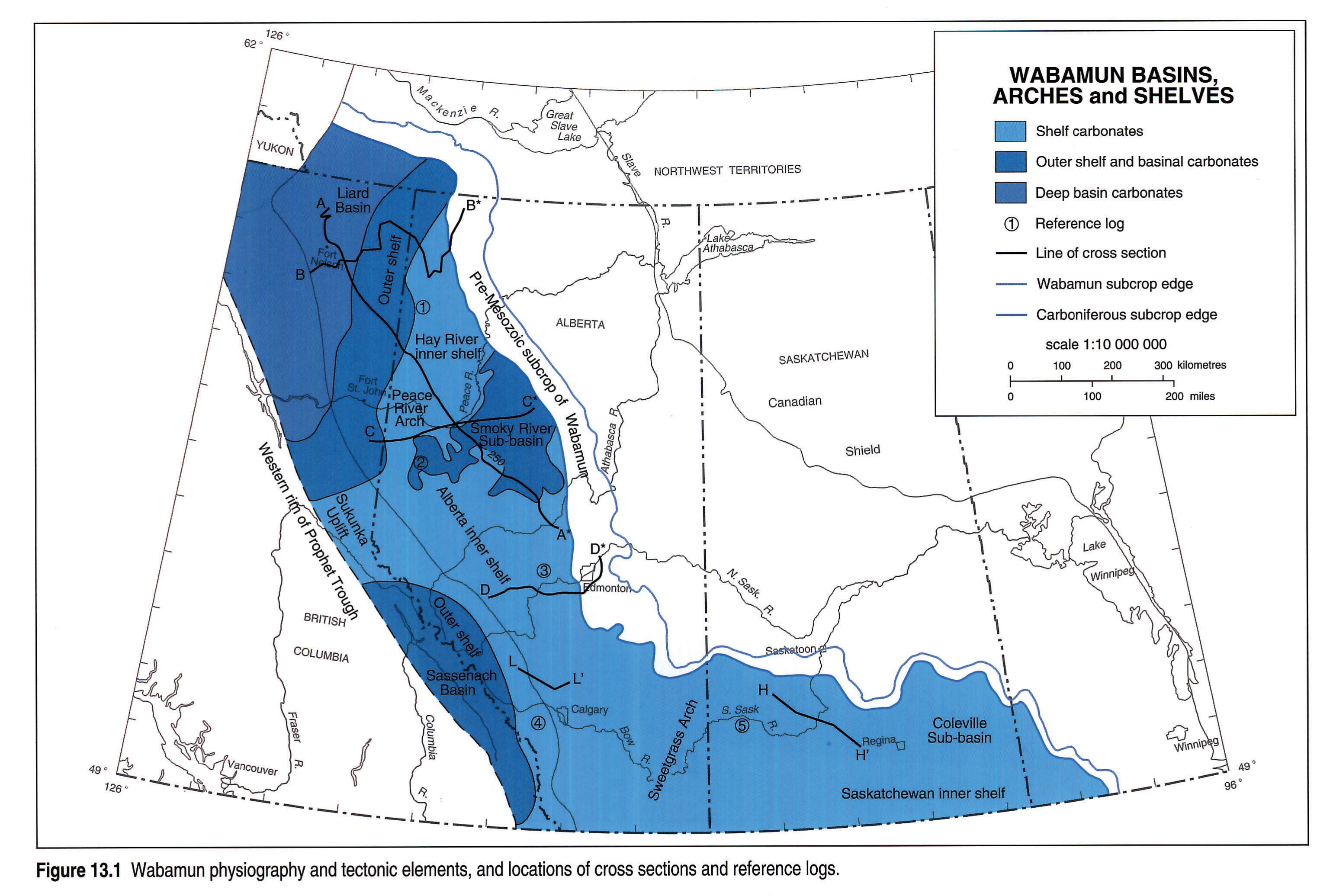
The Famennian subsurface strata of Saskatchewan, Alberta and British Columbia consist of a series of stacked cyclical ramp and shelf carbonates and associated evaporites of the Wabamun Group. These rocks are coeval with Palliser Formation strata exposed in the Rocky Mountain Front Ranges. In northeastern British Columbia the ramp carbonates shale out into the Besa River shales of the Liard Basin. There is some evidence of a shale-out of the Palliser to the west in southeastern British Columbia (Richards, 1989), although stratigraphic relations have been obscured by later tectonic deformation. The eastern and northern margins of the Wabamun Group are defined by pre-Mesozoic erosion. Famennian sedimentary rocks subcrop beneath Mesozoic clastic rocks from Alberta to Manitoba along a belt extending some 700 km (Fig. 13.1).
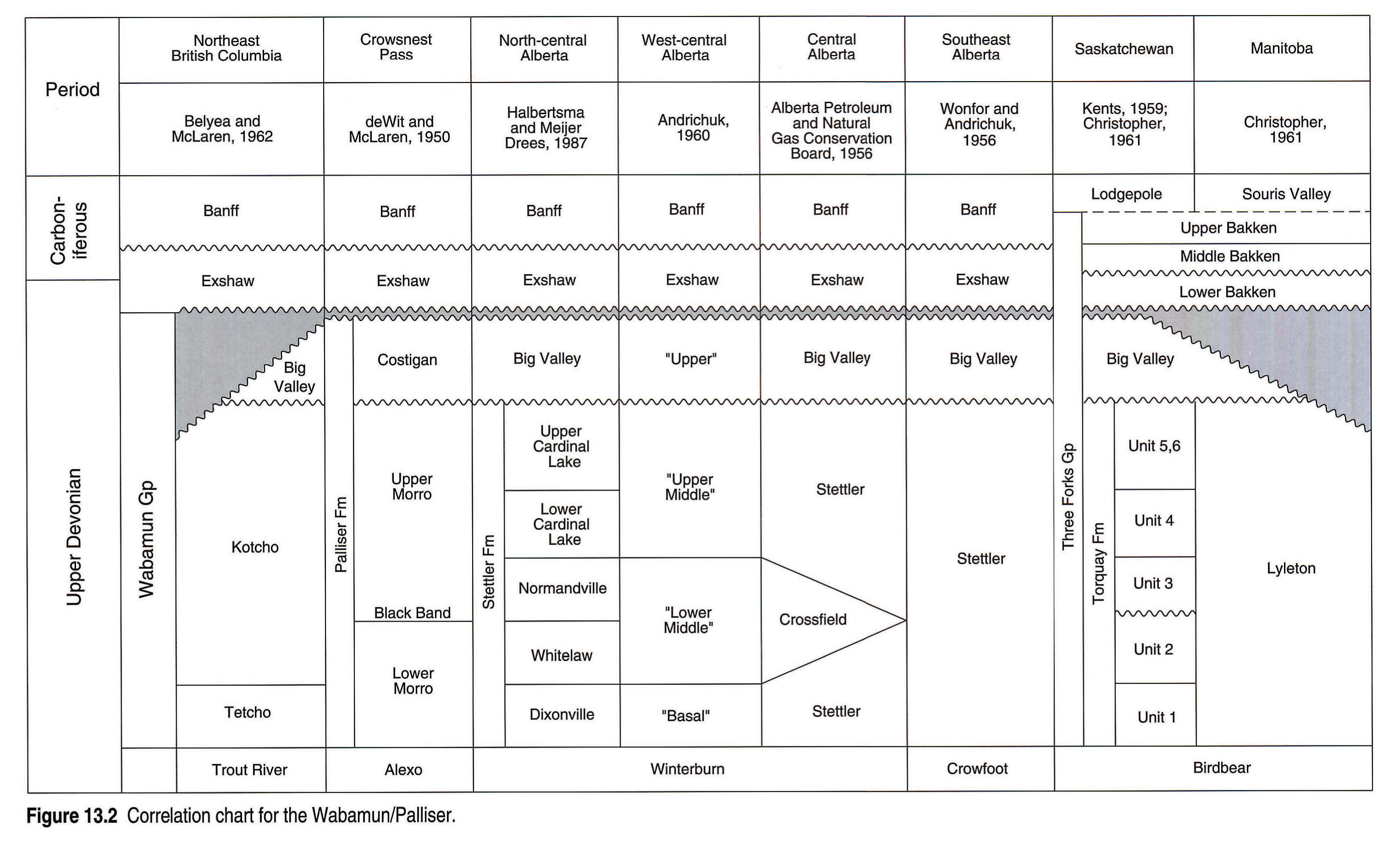
The outcropping Palliser Formation is subdivided into two members: the Morro and the overlying Costigan. These correspond respectively to the Stettler and Big Valley formations of the subsurface Wabamun Group (Fig. 13.2). A major unconformity separates these units in both surface outcrops and the subsurface. Morro carbonates overlie Famennian Sassenach sandstones in the southern Rocky Mountains and Frasnian Simla limestones in the northern outcrop areas. Subsurface Wabamun strata overlie the Famennian upper Graminia Formation. Contact between the Famennian upper Graminia silt and the Wabamun carbonates is gradational, a result of reworking of upper Graminia strata during the Wabamun transgression (see Switzer et al., this volume, Chapter 12).
In the Liard Basin the Famennian part of the Besa River shales grades eastward into carbonates and shales of the Tetcho and overlying Kotcho formations (Fig. 13.2). These sediments interfinger with shallow-water shelf carbonates of the Stettler Formation via a ramp relationship. Stettler cyclic shelf carbonates grade southeastward into evaporite-dominated sediments. In Saskatchewan, equivalent strata are siliciclastics and dolomites of the Torquay Formation, and in Manitoba, redbed strata of the Lyleton Formation (Fig. 13.2).
Sediments of the overlying Costigan-Big Valley interval are less widespread than those of the Stettler Formation. A shallow sea spread northward across the shelf from Montana through southwestern Saskatchewan and southern Alberta into north-central Alberta. Open-marine fossiliferous limestones and shales were deposited, with restricted sediments occurring locally; for example, in the Coleville Basin in Saskatchewan. The northern and eastern present-day limits of Costigan and Big Valley sediments are erosional (Fig. 13.1).
Costigan-Big Valley carbonates and shales are overlain by the Exshaw/Bakken shales and the Banff siliciclastics and carbonates.
Previous Work
The regional distribution and geology of Palliser-Wabamun strata was described in the previous atlas - Geological History of Western Canada (Belyea, 1964). Much of the knowledge at that time came from the work of Beales (1956) and Sutterlin (1958), and the regional work of Andrichuk (1960) in west-central Alberta, and Christopher (1961) in Saskatchewan.
More recently, regional aspects of Palliser sedimentation were discussed by Morrow and Geldsetzer (1988) and regional Wabamun stratigraphy by Moore (1989). Their work complements work on equivalent strata in the Western United States by Sandberg et al. (1988). Recently, Richards et al. (1991) published significant conodont data, which improved correlations from the United States into Canada.
The early work by Andrichuk (1960) was extended by Metherell and Workman (1969) and Workman and Metherell (1969), with a detailed study of the Crossfield Member in the Stettler Formation of central Alberta. A depositional model for the Crossfield was developed by Eliuk (1984). The concept of sequence stratigraphy was applied to the Palliser Formation in the Moose Mountain area by Styan (1984).
Halbertsma and Meijer Drees (1987) subdivided Stettler-equivalent carbonates in the Peace River Arch area of north central Alberta into four mappable units. Nishida (1987) published on Wabamun patch reefs. Possible hydrothermal dolomitization was discussed by Stoakes (1987) and Packard and Pellegrin (1989). Churcher and Majid (1989) compared fault-bounded reservoirs in the Tangent area with the Ordovician Albion-Scipio play in the Michigan basin. Workum (1991) suggested that localized dolomite reservoirs may have been formed in association with subaerial karst.
Stratigraphic Nomenclature
Stratigraphic units in Palliser/Wabamun strata are illustrated in the correlation chart (Fig. 13.2).
Major unconformities, apparently equivalent in age, separate the outcropping Palliser Formation into the Morro and Costigan members and the subsurface Wabamun into the Stettler and Big Valley formations (Wonfor and Andrichuk, 1956; Richards et al., 1991).
The Tetcho Formation and overlying Kotcho Formation of northeastern British Columbia are coeval with the Stettler Formation of Alberta. In north-central Alberta, Stettler carbonates are subdivided into four members. In ascending order they are: the Dixonville, Whitelaw, Normandville and Cardinal Lake members (Halbertsma and Meijer Drees, 1987). The Crossfield Member is developed as a wedge in the middle of the evaporitic facies of the Stettler Formation in central and southern Alberta. It is considered equivalent to the combined Whitelaw and Normandville members of north-central Alberta. The Torquay Formation in Saskatchewan is the equivalent of the Stettler succession and can be subdivided into six units, of which the middle unit (No. 3) is possibly the equivalent of the Normandville Member of Alberta (Christopher, 1961).
The Big Valley Formation is eroded over and north of the Peace River Arch. It is, however, widely developed over central and southern Alberta and overlies the Stettler-equivalent Torquay Formation in Saskatchewan. The Torquay, Big Valley and Bakken formations of Saskatchewan together comprise the Three Forks Group.
Geological and Tectonic Framework
Famennian Palliser/Wabamun cratonic basins can be subdivided into several major elements, reflecting their varied structural history (Fig. 13.1). The farthest basinward sediments are contained in the Liard Basin and in outer shelf or basin slope settings in northeastern British Columbia. Shelf sediments occur on the Hay River and Alberta inner shelf areas, separated by the Peace River Arch. The Smoky River Sub-basin is developed on the Alberta inner shelf area just south of the Peace River Arch. Infilling carbonates reflect a slight deepening of the environment. Along the deformed belt, the Sukunka Uplift in the northern Rocky Mountains separates deeper sediments of the Liard Basin from those of the Sassenach Sub-basin in southeastern British Columbia. Inner shelf carbonates, evaporites (Sweetgrass Arch area) and clastics occur to the southeast and east in a more landward position. More restricted clastics occur in the eastern-most Coleville1 Sub-basin, which is developed on the Saskatchewan inner shelf.
Onlapping relations show that the Peace River Arch remained high-standing but relatively inactive during Stettler sedimentation. This tectonic stability during Stettler deposition holds true for much of the shelf areas.
Relative sea-level changes during Stettler deposition appear to be mostly eustatic. This is particularly the case for transgressive upper Morro/Normandville patch reef and mud-mound carbonates, which can be correlated with similar age mud-mounds in Utah-Nevada and Belgium.
A major erosional unconformity, however, separates the Costigan/Big Valley and Morro/Stettler strata (Fig. 13.2) and very likely represents the onset of a period of structural instability. This tectonism, which continued well into the Carboniferous (Antler Orogeny), is evidenced by post-Stettler uplift and erosion of the Costigan/Big Valley section in the northern Rocky Mountains, the Liard Basin and the Peace River Arch. Geldsetzer (1982) reported erosional removal of the entire Palliser section north of latitude 54°N and west of longitude 121°W. Bentonites in Big Valley mudstones in Saskatchewan, and volcanic ash interbedded with Exshaw shales in southeastern and northeastern British Columbia indicate volcanism.
Thickness and Lithology
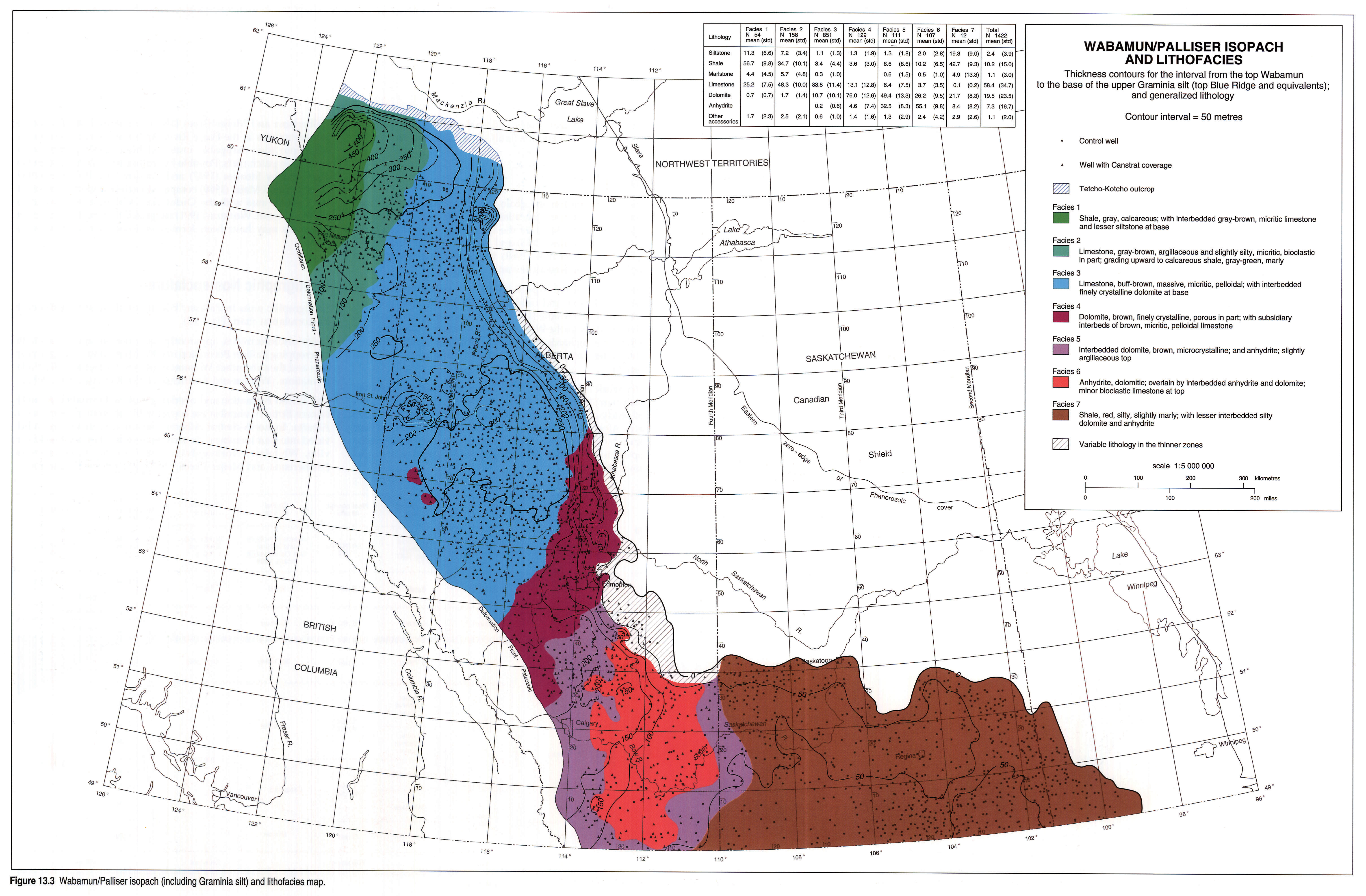
The total Wabamun isopach map (Fig. 13.3) reflects true stratigraphic thickness of about 50 m in Saskatchewan, thickening to over 200 m in large parts of Alberta, with further thickening in the northwest in the Liard Basin. There is pronounced thinning over the Peace River Arch (east of Fort St. John). Closely spaced contours along the eastern subcrop edge reflect erosional bevelling at the sub-Cretaceous unconformity. The thickness anomaly near the subcrop zero edge in northernmost Alberta relates to the Steen River impact structure (see Burwash et al., this volume , Chapter 5).
It should be emphasized that the Figure 13.3 isopach interval includes the whole of the Wabamum and equivalents plus the upper Graminia silt, down to the top of the Blue Ridge carbonate and equivalents. This top Blue Ridge pick (sometimes referred to informally as the F Horizon, because it closely approximates the Frasnian-Famennian boundary) is used in Atlas mapping as the most reliable marker for separating strata of Winterburn affinity (Chapter 12) from succeeding strata of Wabamun affinity. The stratigraphic base used in constructing Figure 13.3 is thus identical to the stratigraphic top in the maps illustrated in Chapter 12 (see Switzer et al., this volume).
Wabamun thickness trends are not projected into the disturbed belt because of structural complications. Thicknesses greater than 500 m were reported by Geldsetzer (1982) in the southern Rocky Mountains. These values were, however, measured on fault-repeated sections where accuracy is difficult.
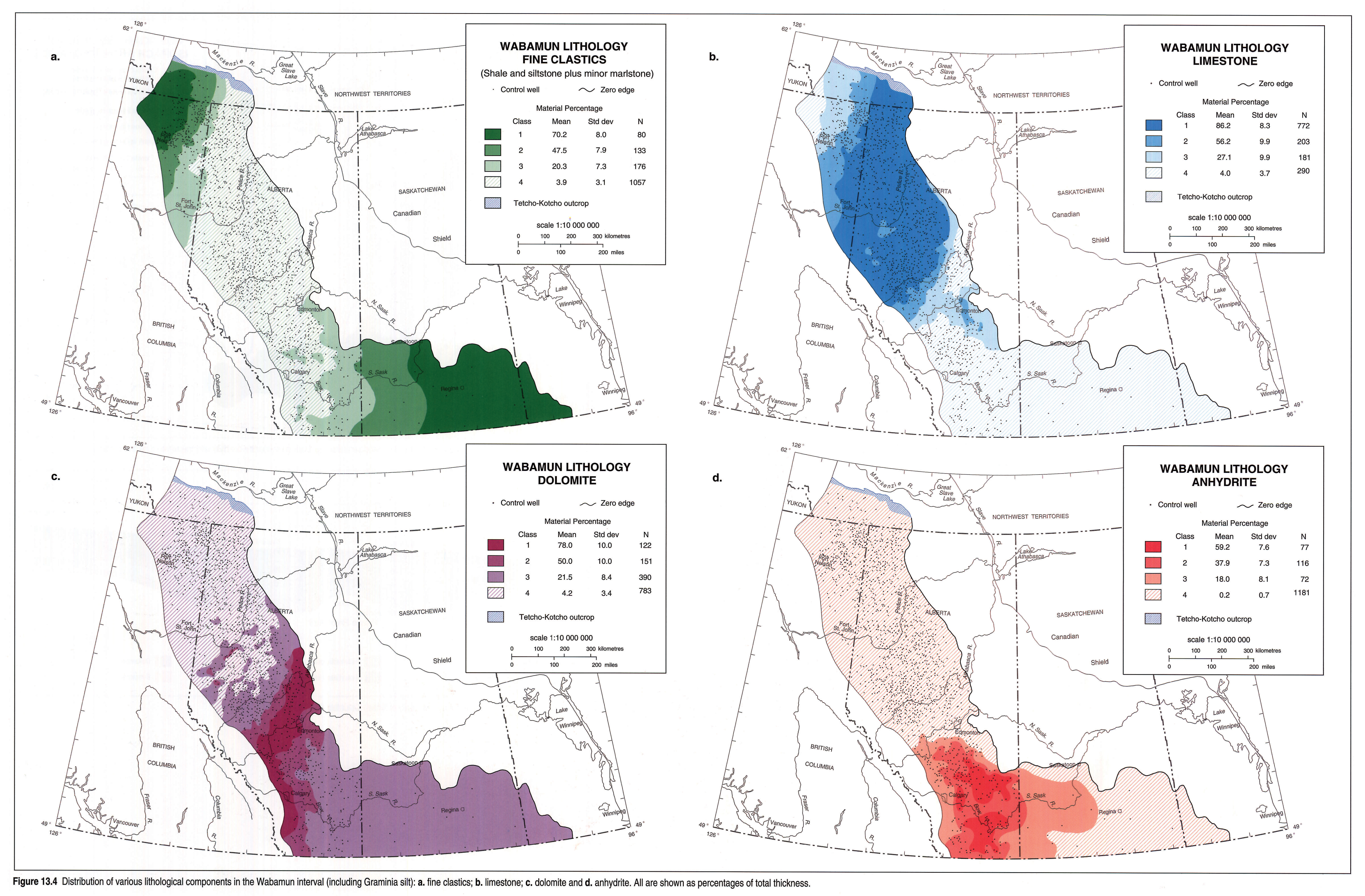
Lithofacies depicted in Figure 13.3, manifest over the whole of the Wabamun isopach interval, reflect generalized but cogent trends - from shales and argillaceous carbonates in the northwest, through limestones in north and west-central Alberta, dolomites and evaporites in southern Alberta, to redbed shales and dolomitic siltstones in southern Saskatchewan and Manitoba. The percentage distributions of selected lithological components are shown in the maps of Figure 13.4.
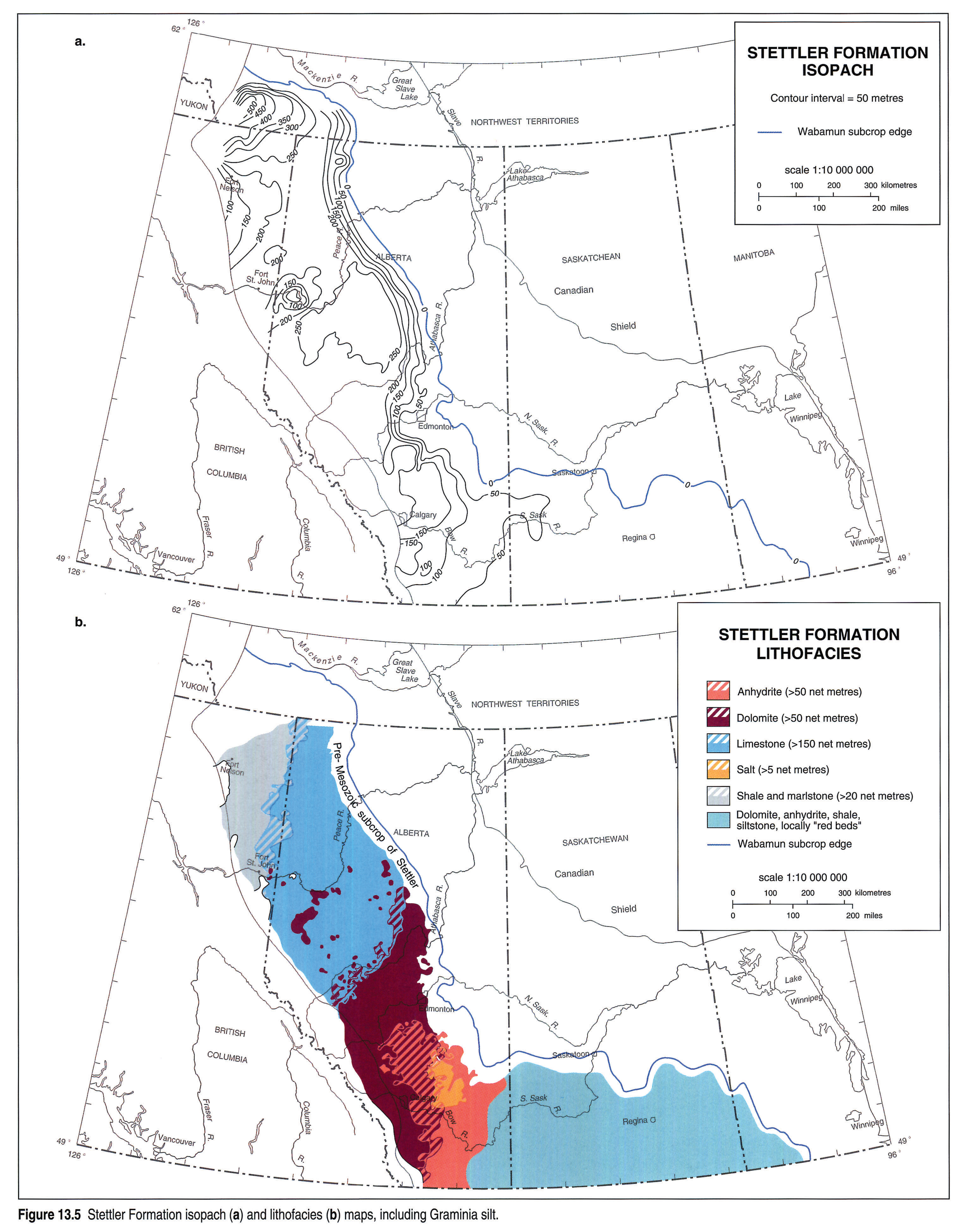
Isopachs of the two principal stratigraphic units of the Wabamun in the subsurface, namely the Stettler and Big Valley, are shown in Figures 13.5 and 13.6. The Stettler reaches a maximum thickness in Alberta of 250 m, in the depocentre east of the Peace River Arch. The Stettler thins to about 30 to 50 m toward the south, into Montana. The overlying Big Valley unit maintains a relatively uniform thickness of 15 to 20 m over most of Alberta and Saskatchewan, with thickness anomalies confined to local areas.
Pre-existing high-standing topography produced onlap thinning of the Wabamun over the Peace River Arch. Later bevelling further thinned the Wabamun in this area (Fig. 13.5). Post-Stettler uplift due to the Antler Orogeny resulted in considerable erosion and total removal of the Big Valley unit in northwestern Alberta and the Liard Basin areas.
Lithologically the Wabamun shows considerable variation. Morro-Stettler sediments, which form the bulk of Wabamun strata, comprise a distinct suite of lithologies that change laterally according to the environment of deposition (Fig. 13.5a). Dark gray to black Besa River shales of the Liard Basin grade up-ramp to the east into shallow-water Stettler carbonates of the Alberta shelf area. Cyclical, tan to brown, extensively bioturbated wackestones, peloidal packstones and grainstones, which were deposited on a large, semi-restricted shelf, cover most of northern and central Alberta. These strata grade eastward and southward into belts of dolomite and intertidal and supratidal stromatolites, cryptalgal laminates and evaporites in southern and southeastern Alberta, reflecting more restricted and shallower water environments. Farther landward, to the east across Saskatchewan and into western Manitoba, restricted nearshore siltstones, redbeds, dolomites and anhydrites comprise the Stettler-equivalent strata.
One lithofacies is of particular interest, namely the peloidal grainstone. According to Beales (1956), the peloid grains in the Stettler grainstones and packstones were formed by rolling and accretion in tidal surf and were subsequently deposited in the interior of banks where currents were slack. During the Dixonville and Normandville transgressions the peloids may have been picked up by longshore currents and deposited elsewhere.
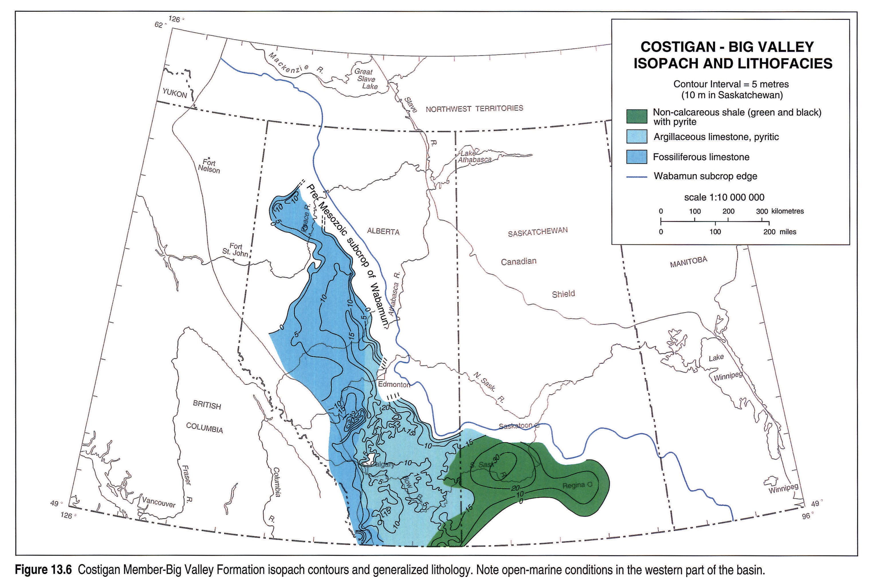
In contrast to the Morro/Stettler interval, overlying Costigan-Big Valley sediments consist of mostly gray, argillaceous, highly fossiliferous and finely pyritic limestones. Among the macrofossils, crinoids and brachiopods are most common and are associated with gastropods, bryozoans and possibly corals (Beales, 1956). Humid conditions were possibly more conducive to organic growth (Kents, 1959, p. 26) and the lack of sabkha evaporites may well be related to reduced salinity as a result of fresh water influx when supply of aerated salt water at the northern threshold decreased. In Saskatchewan (Fig. 13.6), a Big Valley, highly fossiliferous limestone, the "Crystal limestone", interfingers with varicolored to green-black, noncalcareous, pyritic shales of the Coleville Sub-basin.
Depositional and Stratigraphic History
Famennian Wabamun sedimentation in the Western Canada Sedimentary Basin represents an overall regressive sequence punctuated by several important transgressive pulses.
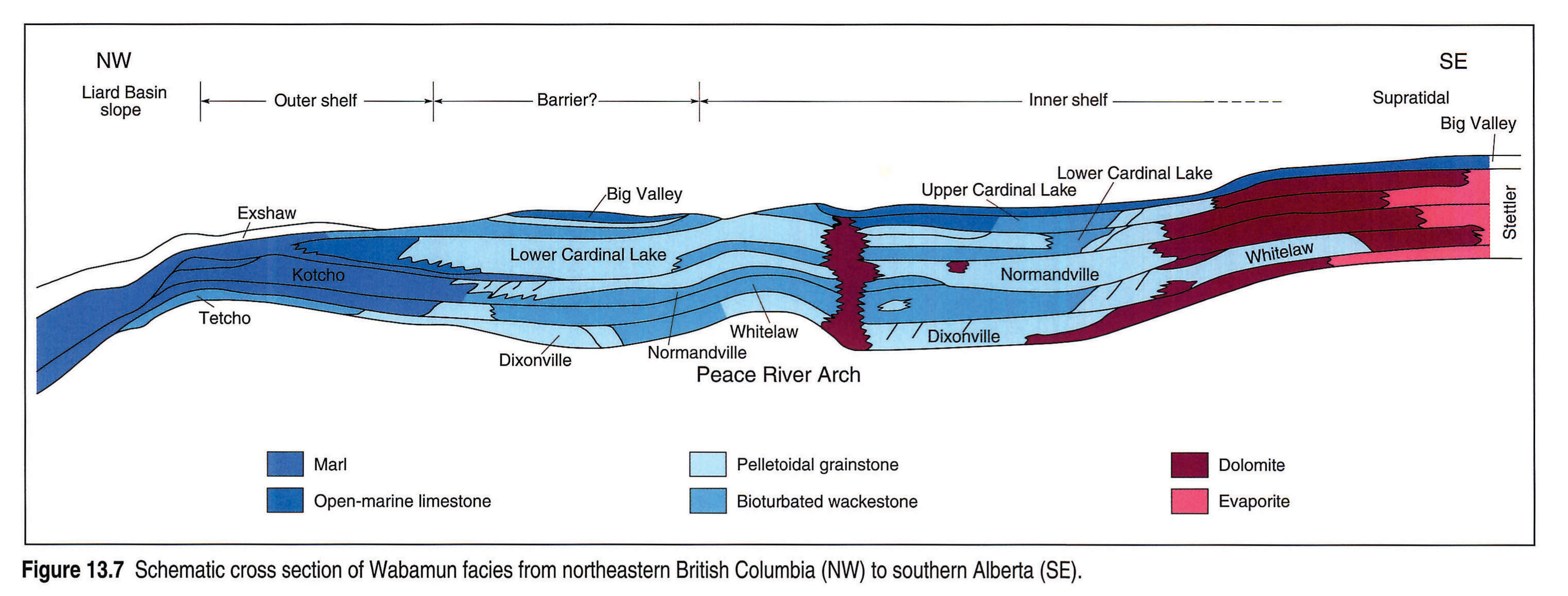
The initial Dixonville transgression is particularly well manifest on the Liard Basin slope, as a westward thinning wedge of open-marine carbonates (Tetcho Formation). The Normandville transgression forms a similar wedge of sediments higher up the ramp and on the shelf, where it is best known as the upper part of the Crossfield Member. Close-of-Wabamun sedimentation was marked by a final transgression during Big Valley deposition. The facies cross section shown in Figure 13.7 schematically depicts the basic relations. The reader is referred to the location map (Fig. 13.1) and the generalized Stettler facies map (Fig. 13.5b) for clarification of the paleogeographic extent of these transgressive events.
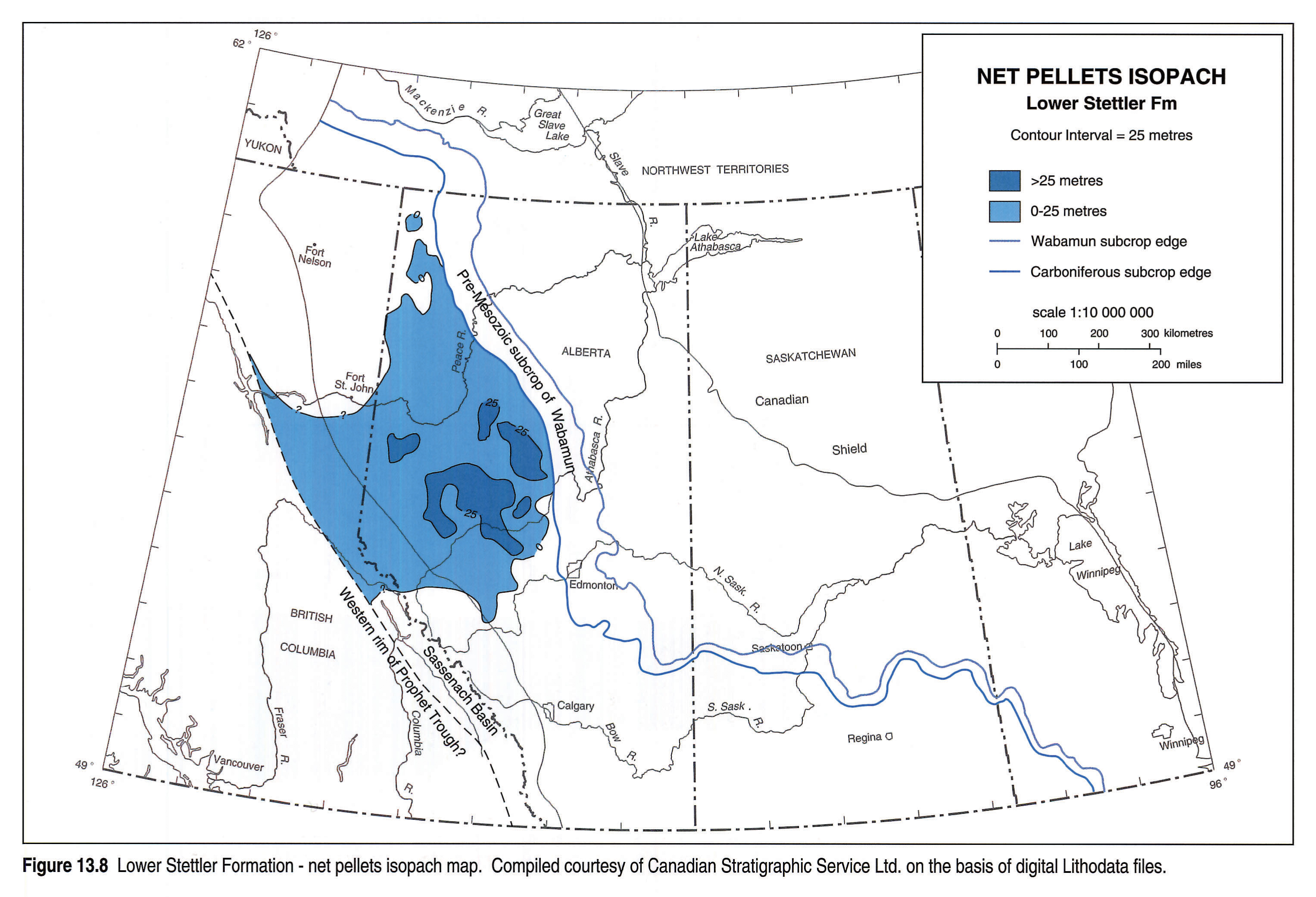
Basin subsidence or eustatic sea-level rise at the beginning of Stettler deposition resulted in an incursion equated to the first Famennian transgression of Sandberg et al. (1988). Resulting deposits were laid down in environments shallowing to the southeast across Alberta into Saskatchewan. Open-marine carbonates comprising skeletal lime mudstones and wackestones were deposited on the Liard Basin slope as the Tetcho Formation (Fig. 13.7). Mudstones and wackestones were laid down on the outer shelf side of the grainstone barrier complex and higher energy packstones and grainstones deposited in the barrier area. Coeval inner shelf carbonate deposits of the Dixonville Member include peloidal packstones, wackestones and an abundance of peloidal grainstone tidal sand bars (Fig. 13.7). The distribution of peloidal grainstones is represented in Figure 13.8, a lower Stettler net peloid isolith map. Of interest is the concentration of peloids in the Smoky River Sub-basin area.
In southern Alberta, dolomites attain their greatest areal extent in the Dixonville Member. Distribution of dolomites in the Dixonville and the overlying Whitelaw members is shown in the composite dolomite isolith map of the Lower Stettler (Fig. 13.9). Evaporites were deposited in a limited area in southeast Alberta (Fig. 13.5b).
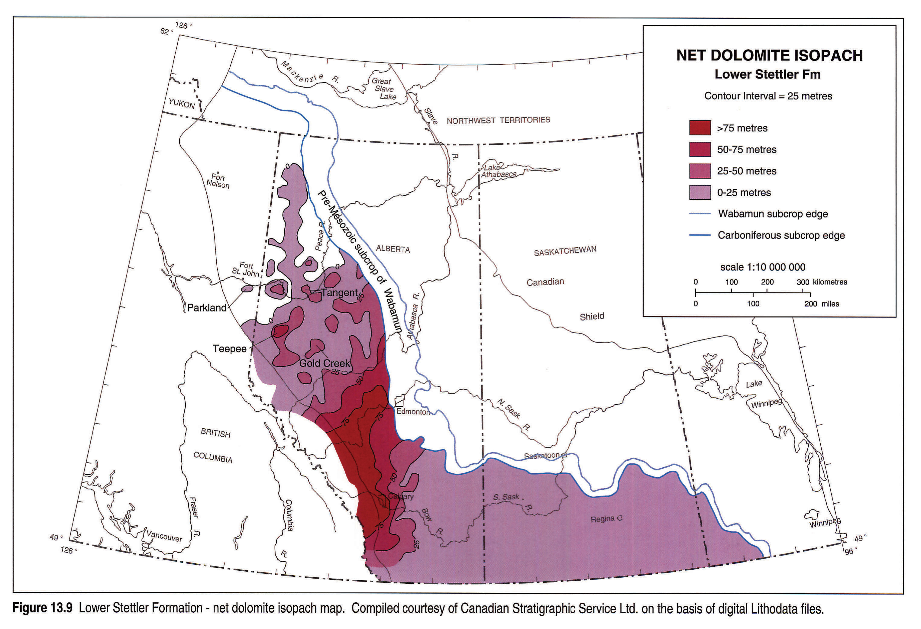
Whitelaw deposits are largely regressive and consist mainly of shallow-water laminated marls, particularly in the northern outer shelf and Liard Basin slope areas (Fig. 13.7). These sediments grade to the southeast into bioturbated wackestones, which in turn shal-low upward into lagoonal carbonates, dolomites and evaporites in central and southern Alberta. During lower Stettler deposition the Peace River Arch was still a significant landmass, against which Dixonville and Whitelaw carbonates onlapped (Fig. 13.10).
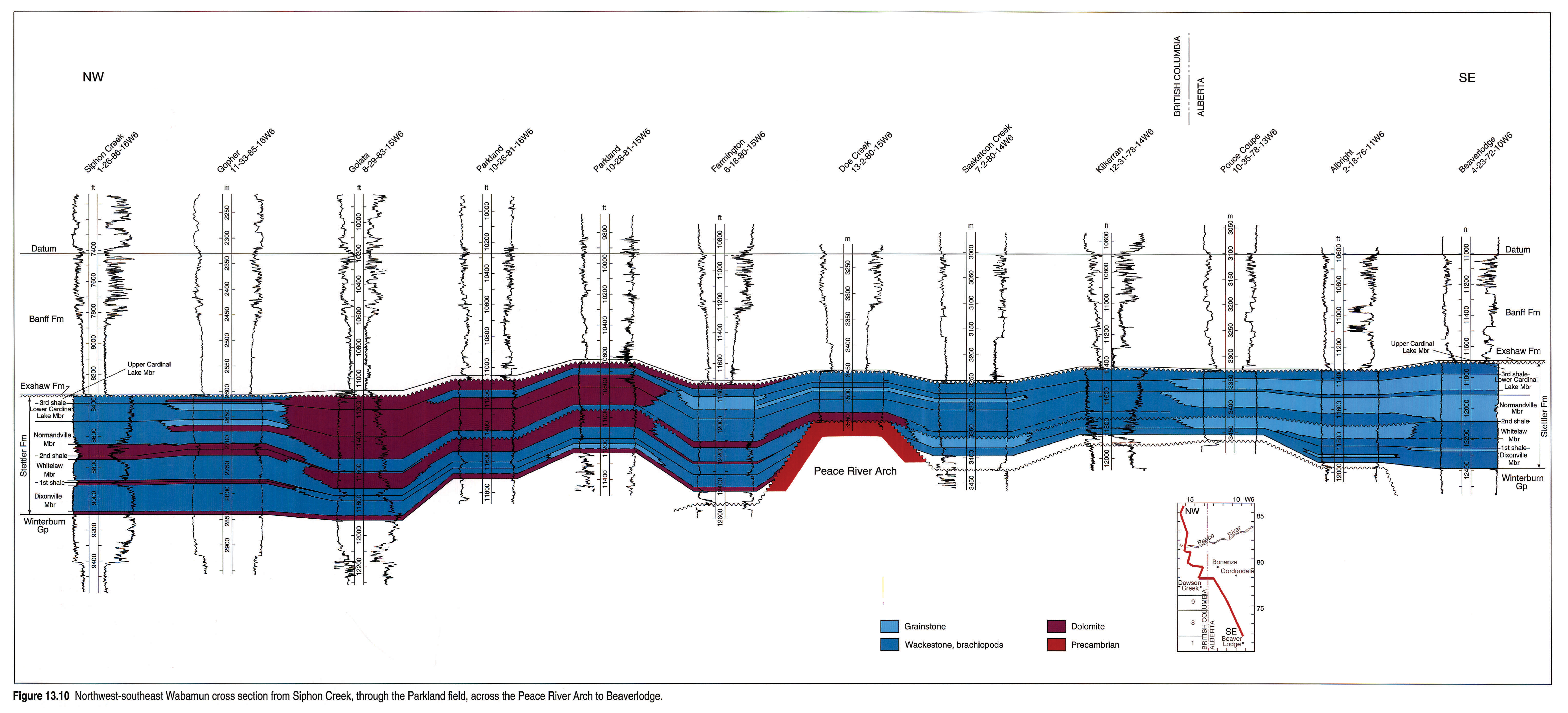
Further details of the lower to upper Stettler transition can be gleaned from outcrops in the Sukunka area of the northern Rocky Mountains (Fig. 13.1). Here the base of the upper Morro is formed by a black, nonfossiliferous, laminated, 10 m thick lime mudstone, the so-called "Black Band". This unit rests with an abrupt contact (hard-ground?) on typical nodular, bedded lower Morro limestones (Geldsetzer, 1982, p. 63). Geldsetzer (op. cit.) suggested that the association of a black laminated lime mudstone grading up- section into beds with algal structures indicates shallow lagoonal conditions. Alternatively, Stoakes (1980, p. 367) argued that these sediments represent accumulation in deep-water, low-energy conditions. Lamination appears to consist of very fine carbonate material and dark organic-rich layers that were essentially undisturbed in the oxygen-starved euxinic conditions found in basin deeps.
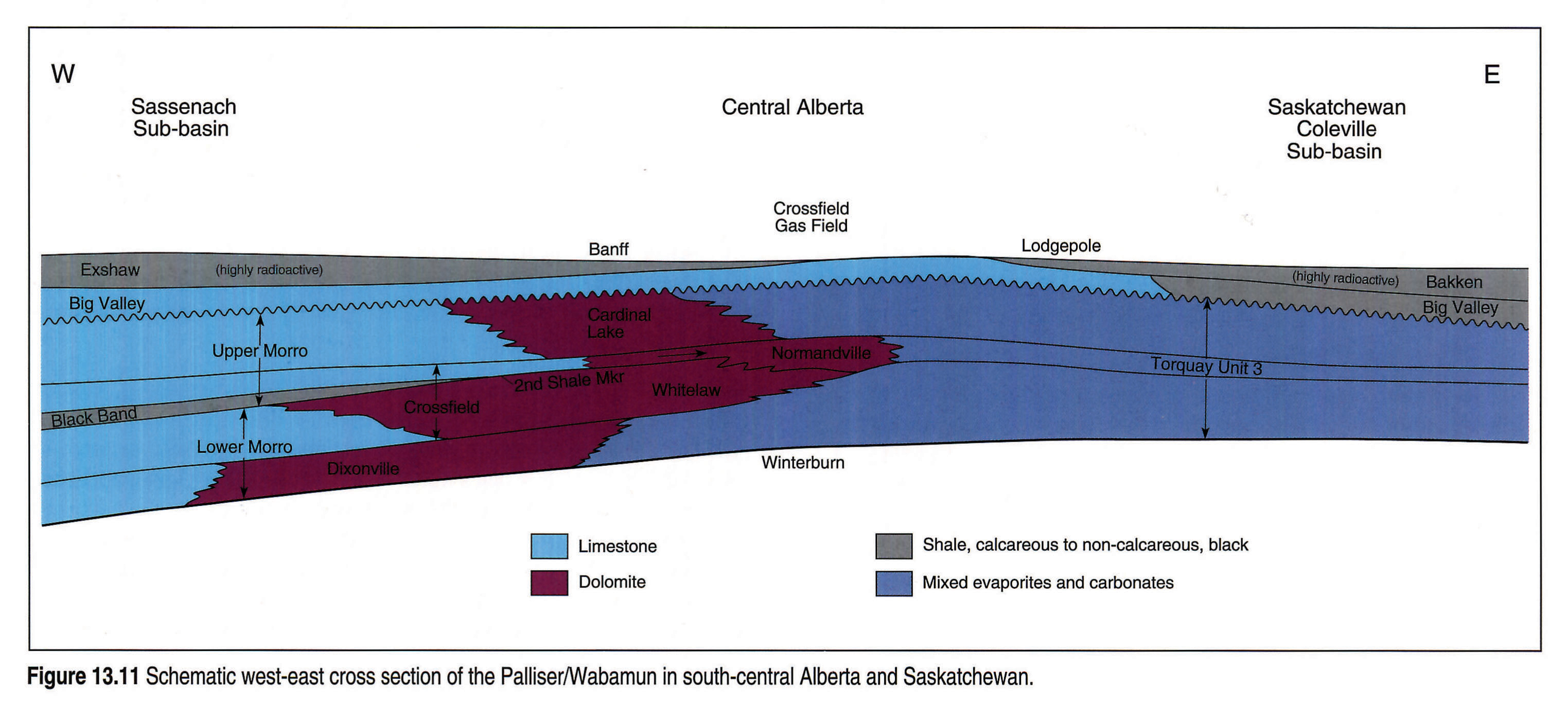
In the subsurface, the "Black Band" limestone is represented by a thin, dark, nodular, muddy limestone known as the "second shale marker" (Fig. 13.10). This unit is considered to be the boundary between the Whitelaw and the Normandville members, at the lower/upper Stettler contact (see Halbertsma and Meijer Drees, 1987). It is a distinctive gamma-ray log marker. The position of the "Black Band" and the shale marker are illustrated in the schematic cross section through the Sassenach Basin, central Alberta to Saskatchewan (Fig. 13.11). The black laminated lime mudstone ("Black Band") at the base of the upper Morro in outcrop is not developed in the subsurface Crossfield Member.
The onlapping upper Stettler Normandville Member accumulated during a transgression, the second Famennian transgression of Sandberg et al. (1988, p. 202), in a seaway that stretched from the Northwest Territories to Nevada. During this extensive transgression a primitive stromatoporoid (Labechia) migrated into the inner shelf of Alberta and formed patch reefs on the northern slope of the Smoky River Sub-basin (Nishida, 1987) and mud-mounds in the upper Crossfield Member (Normandville) in southern Alberta.
The Peace River Arch was almost covered by onlapping Normandville strata (Fig. 13.10). A high percentage of the Normandville strata are grainstones of beach origin, containing peloids formed at the foreshore. Winnowed grainstones may have been transported to other parts of the shelf. Distribution of these peloidal rocks and those of the overlying Cardinal Lake Member is depicted in Figure 13.12, an isolith of net peloids in the upper Stettler. There is a high concentration of peloids in the Smoky River Sub-basin (area enclosed in the 250 m contour on the Wabamun/Palliser isopach map, Fig. 13.3). A green shale, unit 3, in the middle of the Torquay Formation in Saskatchewan (see Fig. 13.11) suggests a correlation with Normandville transgressive deposits in Alberta (see Christopher, 1961). Dolomite is present in the Normandville and Cardinal Lake units in a north-south-trending belt through central and southern Alberta. Figure 13.13 shows this trend, as well as the distribution of the dolomite associated with the Peace River Arch. The areal extent of upper Stettler evaporites in southeastern Alberta was even less than that of the lower Stettler.
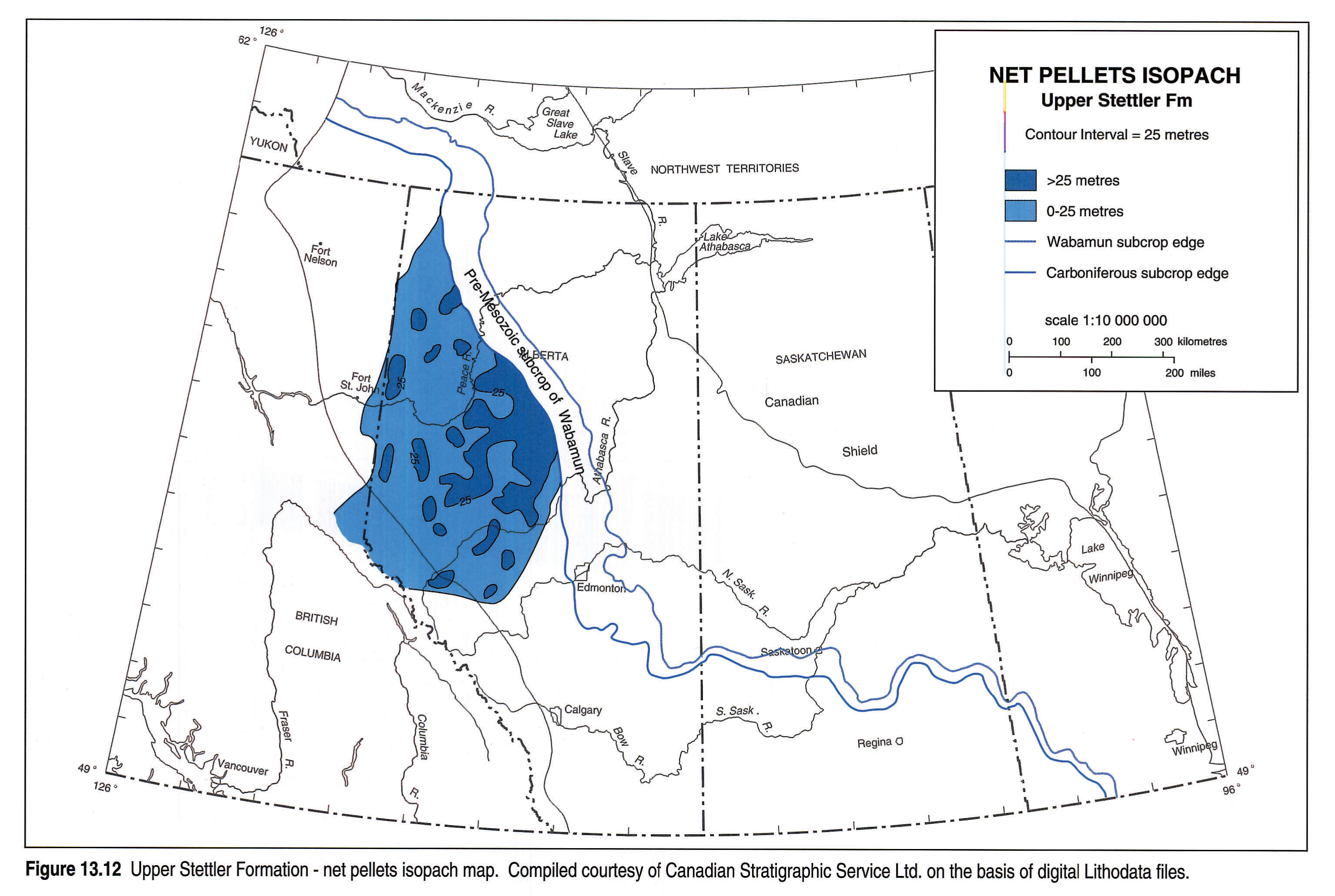
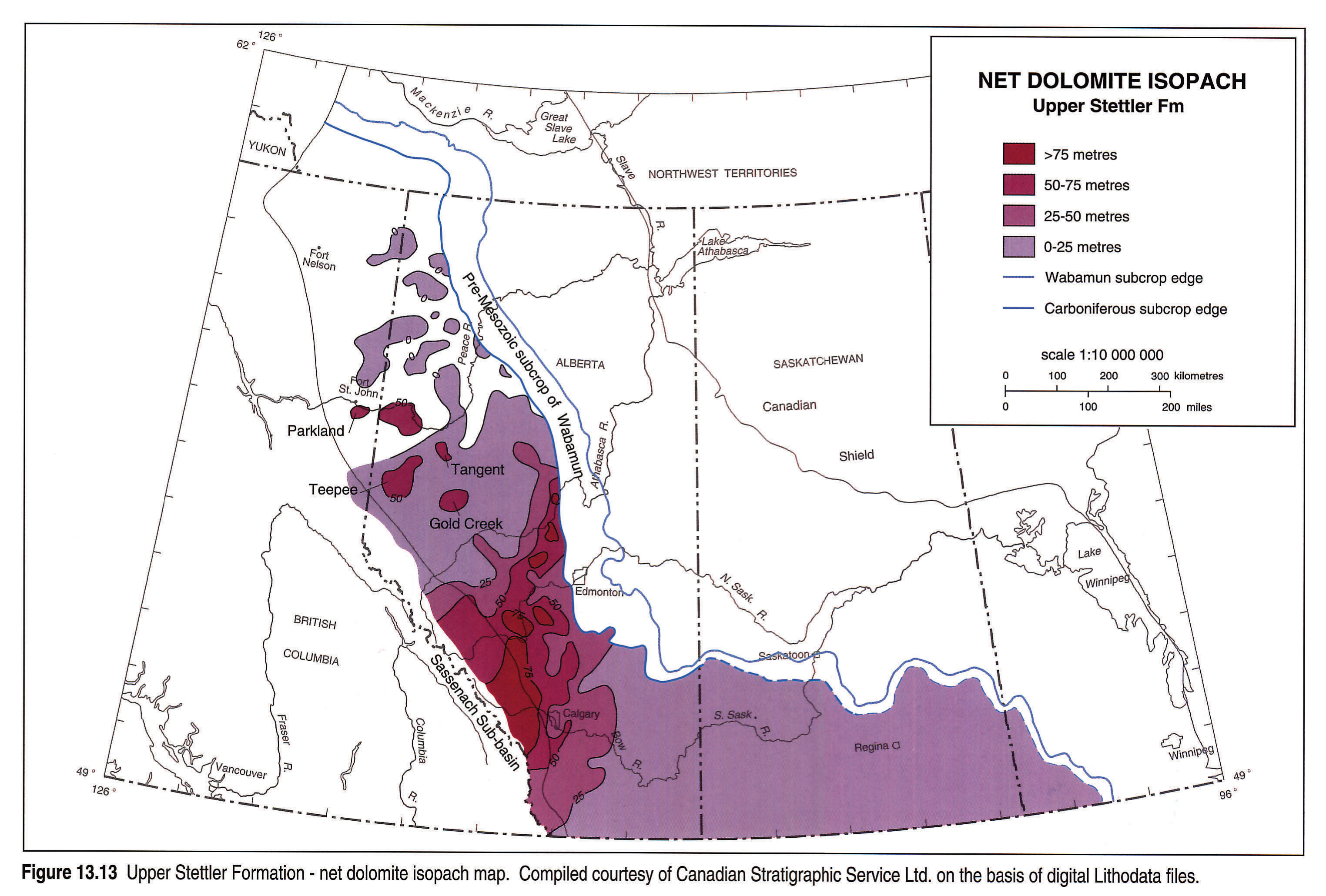
The overlying regressive Cardinal Lake deposits are muddier than the peloidal Normandville carbonates, grading from packstones to supratidal carbonates with birdseye structures, cryptalgal laminates, stromatolites, breccias and dolomites. The upper Cardinal Lake limestones in northern Alberta are particularly muddy, resembling the nodular Whitelaw wackestones. Erosion has removed considerable sections of the upper Cardinal Lake, in particular in the Peace River Arch area. In southeastern Alberta, Cardinal Lake carbonates grade into evaporites along the supratidal belt common to all Stettler units.
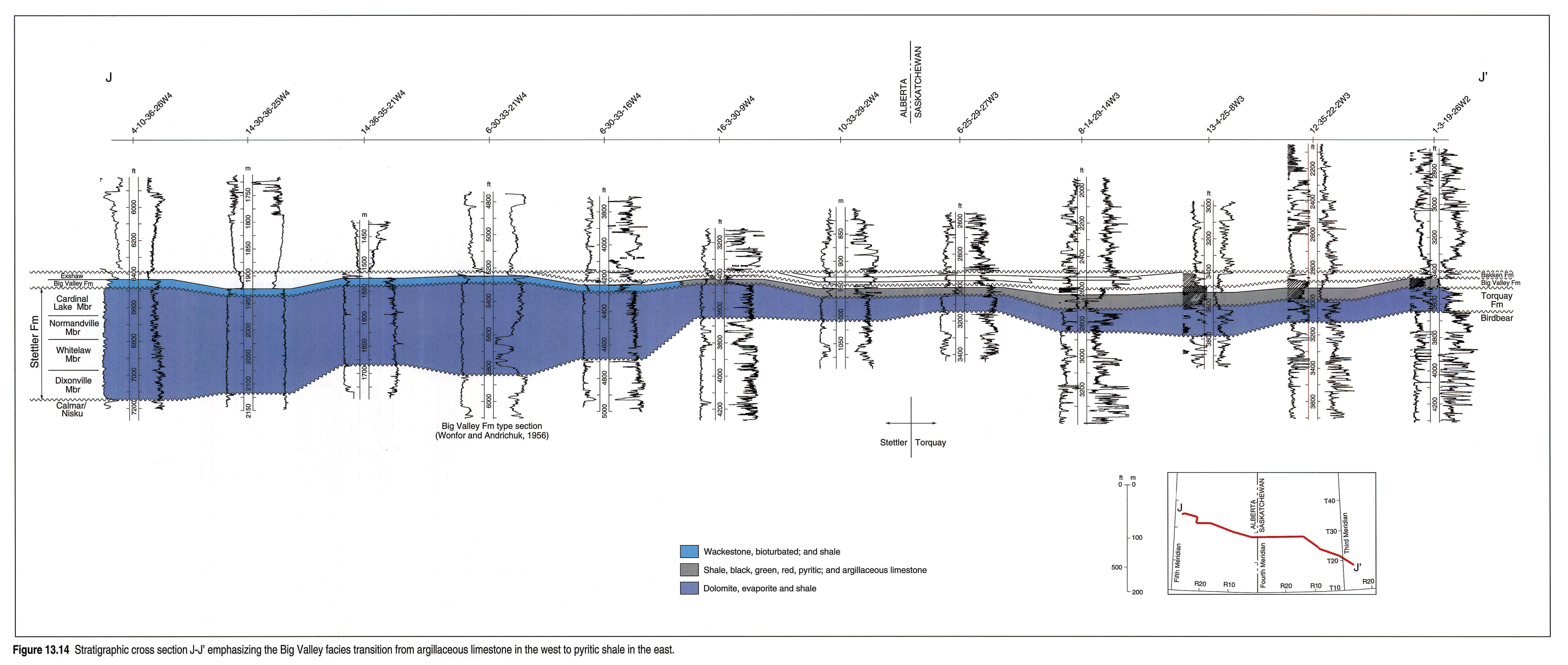
Costigan-Big Valley carbonates and calcareous shales, which unconformably overlie the Morro-Stettler strata (Richards et al., 1991), were deposited during a transgression, the third Famennian transgression of Sandberg et al. (1988). A preliminary combined isopach and facies map (Fig. 13.6) based on work by Sutterlin (1958), Christopher (1961) and Halbertsma (unpublished maps), and a cross section (Fig. 13.14), illustrate the distribution of the Costigan-Big Valley carbonates and shales in southern Alberta and Saskatchewan.
An important faunal hiatus separates the Costigan-Big Valley carbonates from the underlying Morro-Stettler strata. Conodont studies by Richards et al. (1991) indicate that much of what previously has been assigned to the Costigan-Big Valley beds is in fact age-equivalent to the upper Morro-Stettler strata and correlates with the subsurface Cardinal Lake.
Costigan-Big Valley carbonates are low-energy, gray lime wackestones and packstones with minor grainstone interbeds. They are fossiliferous and contain considerable amounts of clay (Sutterlin, 1958). Evaporites are rare. Important is the argillaceous character of the Big Valley carbonates in the eastern part of the basin. Abundant pyrite nodules and green shale interbeds in the highly fossiliferous (mostly crinoids and brachiopods), argillaceous limestone suggest a reducing depositional environment for the shales (Wonfor and Andrichuk, 1956). A similar limestone is developed in the Coleville Sub-basin in the western part of Saskatchewan, where it is named the "Crystal Limestone" (Kents, 1959). He described it as a gray, sandy, biostromal limestone consisting of shell fragments and peloids. Eastward, as shown in the cross section (Fig. 13.14), this limestone gives way to varicolored to green-black, noncalcareous Big Valley shales. These latter shales, which were deposited under shallow, anoxic conditions, are strongly pyritic, with some pyrite layers being up to 4 cm thick. According to Christopher (1961), these Big Valley shales are very similar to the overlying green and black Bakken shales, which represent the fourth Famennian transgression of Sandberg et al. (1988, p. 206).
In northeastern Montana the 22 m thick Trident Member of the Three Forks Formation (possibly equivalent to the Big Valley carbonates) consists largely of varicolored, greenish gray to olive gray shale. The bottom 7 m, however, is yellow to medium gray dolomitic limestone and silty dolomite. The top 3 m is a massive bed of fossiliferous, argillaceous limestone, and it is this limestone that is suspiciously similar to the "true" Big Valley in Alberta, whereas the shales have affinity with the Big Valley shales in the Coleville Sub-basin. Farther west, the shale is much thicker (15 m) and contains interbeds and nodules of green to gray, highly fossiliferous, argillaceous limestone, which increase in number and thickness toward the top (Sandberg, 1965, p. N13). From these descriptions it appears that only the upper 15 m of shale and very fossiliferous, argillaceous limestone at the top of the Trident Member may correlate with the Big Valley. The lower 7 m of dolomite and dolomitic limestone very likely belong to the underlying Logan Gulch Member of the Three Forks Formation (based on biostratigraphic data) (see subsequent discussion).
Local and Sub-regional Relations
Two different areas of Wabamun sedimentation are discussed below, to illustrate details of Wabamun stratigraphic and depositional relations.
Peace River Arch
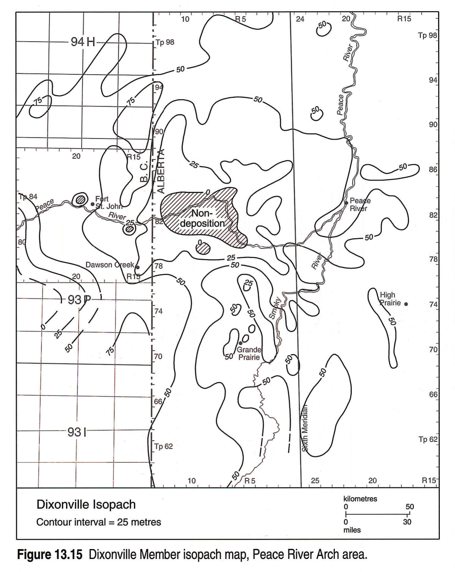
Although high-standing, there are no indications that the Peace River Arch was tectonically active during Stettler deposition. Dixonville-Whitelaw carbonates only partly onlap the arch (see Figs. 13.10 and 13.15). The Dixonville Member also thins toward the slope deposits of the Liard Basin, where equivalent strata are named the Tetcho Formation.
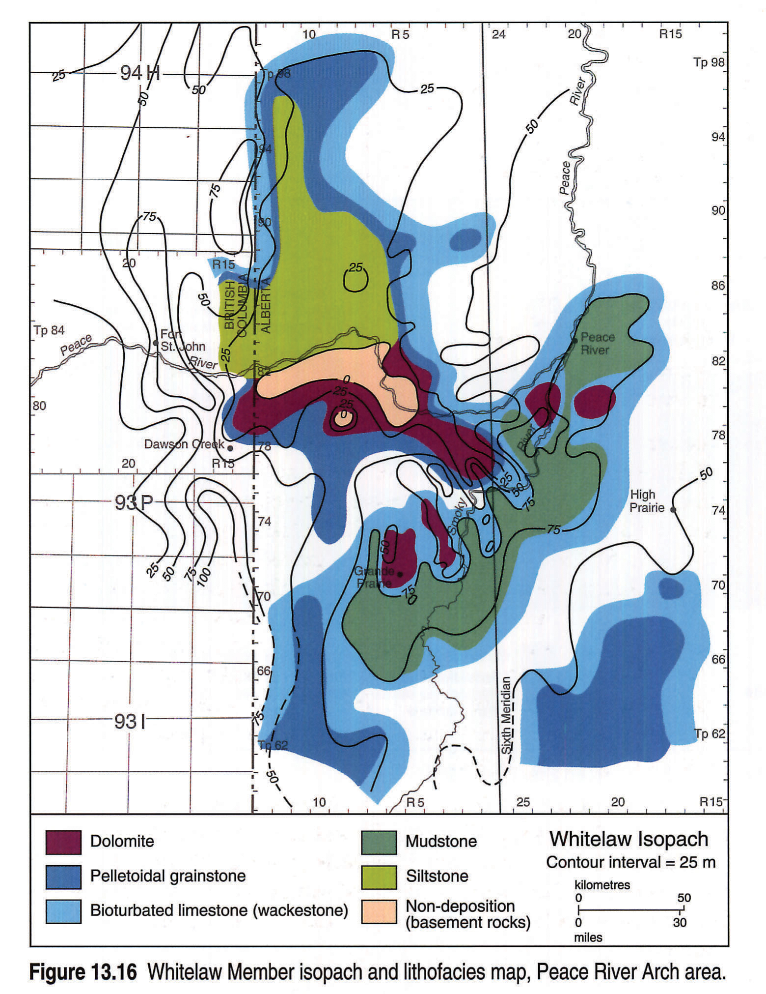
Distribution of facies and stratal thickness of the Whitelaw Member (Fig. 13.16) appear to be controlled by underlying relief on the arch. For example, silty siliciclastics and marls are closely associated with the exposed portion of Precambrian basement along the crest of the arch, as are dolomites of closely surrounding carbonates. These facies are in turn rimmed by shallow, high-energy peloidal grainstones. Slightly deeper (thicker) parts of the area accumulated bioturbated wackestones. To the east, in the Smoky River Sub-basin, mudstones were deposited.
Normandville carbonates, however, practically cover the Arch (Fig. 13.17). Shallowing of the environment characterizes this unit. Again, close association of facies, isopach values and distance from the crestal areas can be seen. Dolomites are surrounded by grainstones, which grade, in the deeper water parts, to bioturbated limestones. The peloidal grainstones are very likely foreshore beach deposits that were further distributed by longshore and tidal currents.
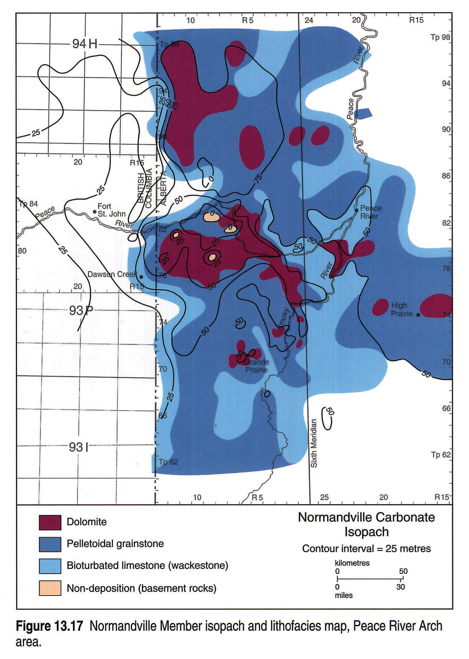
Associated with the Normandville transgression was the development of stromatoporoid patch reefs (Nishida, 1987). One example is situated in the Normandville area of west-central Alberta, (Tp 79, R 22, W5M) on the northern slope of the Smoky River Sub-basin and on the lee side of the Peace River Arch. The overall geometry of the patch reef is uncertain, but it appears to trend northeast-southwest. Its length is approximately 4 km, width more than 1 km, and height 10 m (see cross section, Fig. 13.18).
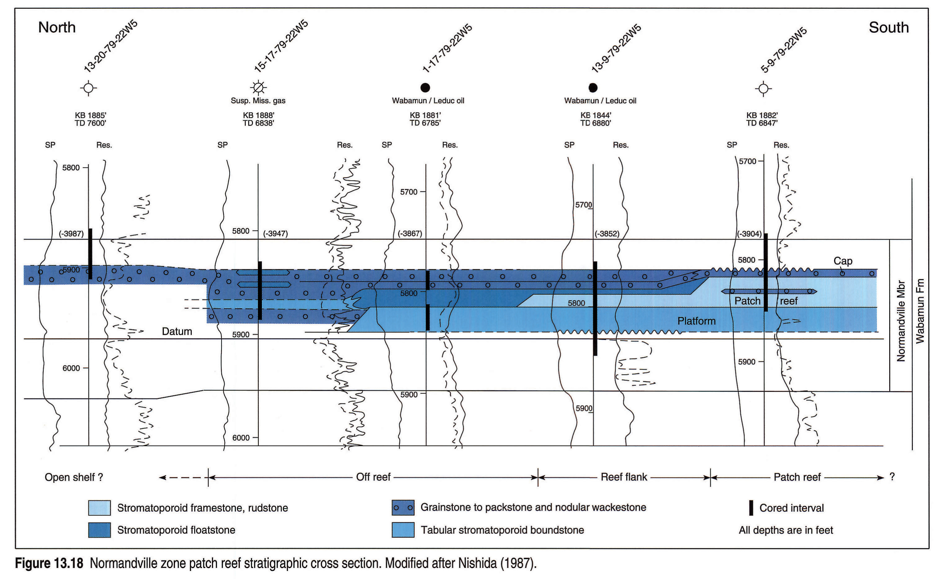
Nishida (1987) established six facies types associated with the patch reefs: open shelf, platform, reef, reef flank, off-reef and cap facies. The open shelf facies consists of peloidal and skeletal grainstone and nodular wackestone. The platform facies comprises tabular bindstone to floatstone with peloidal and skeletal mudstone, wackestone and packstone matrix. The reef facies consists of bulbous and tabular stromatoporoid framestone, rudstone and bindstone with a peloidal grainstone and packstone matrix. The reef flank facies is similar to that of the patch reef except it has more grainstone to packstone matrix. The off-reef, grainstone to packstone grades to wackestone. The cap facies is peloidal skeletal grainstone grading to packstone.
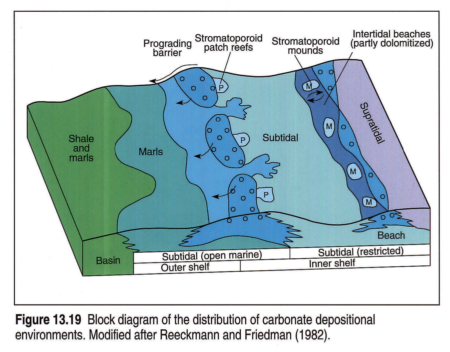
The patch reefs are positioned slightly basinward, on the lee side of the Peace River Arch. This is different from the mud-mounds in southern Alberta, which are nearshore (see Fig. 13.19). The patch reefs occur in the Normandville Member, which correlates approximately with the producing zone in the upper Crossfield Member.
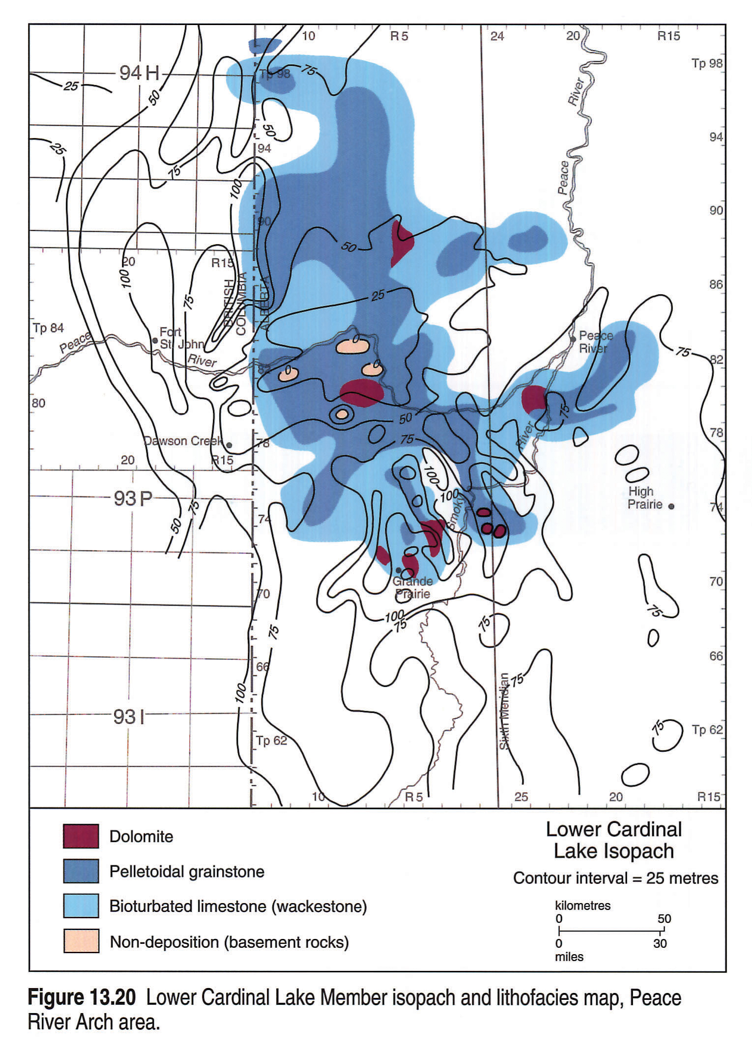
A slight shallowing of the overall environment during lower Cardinal Lake deposition is reflected by the isopachs and limestone facies (Fig. 13.20). Thicker sections of subtidal wackestones cover large areas, but these grade laterally into supratidal birdseye limestones, grainstones and dolomites over the arch crest.
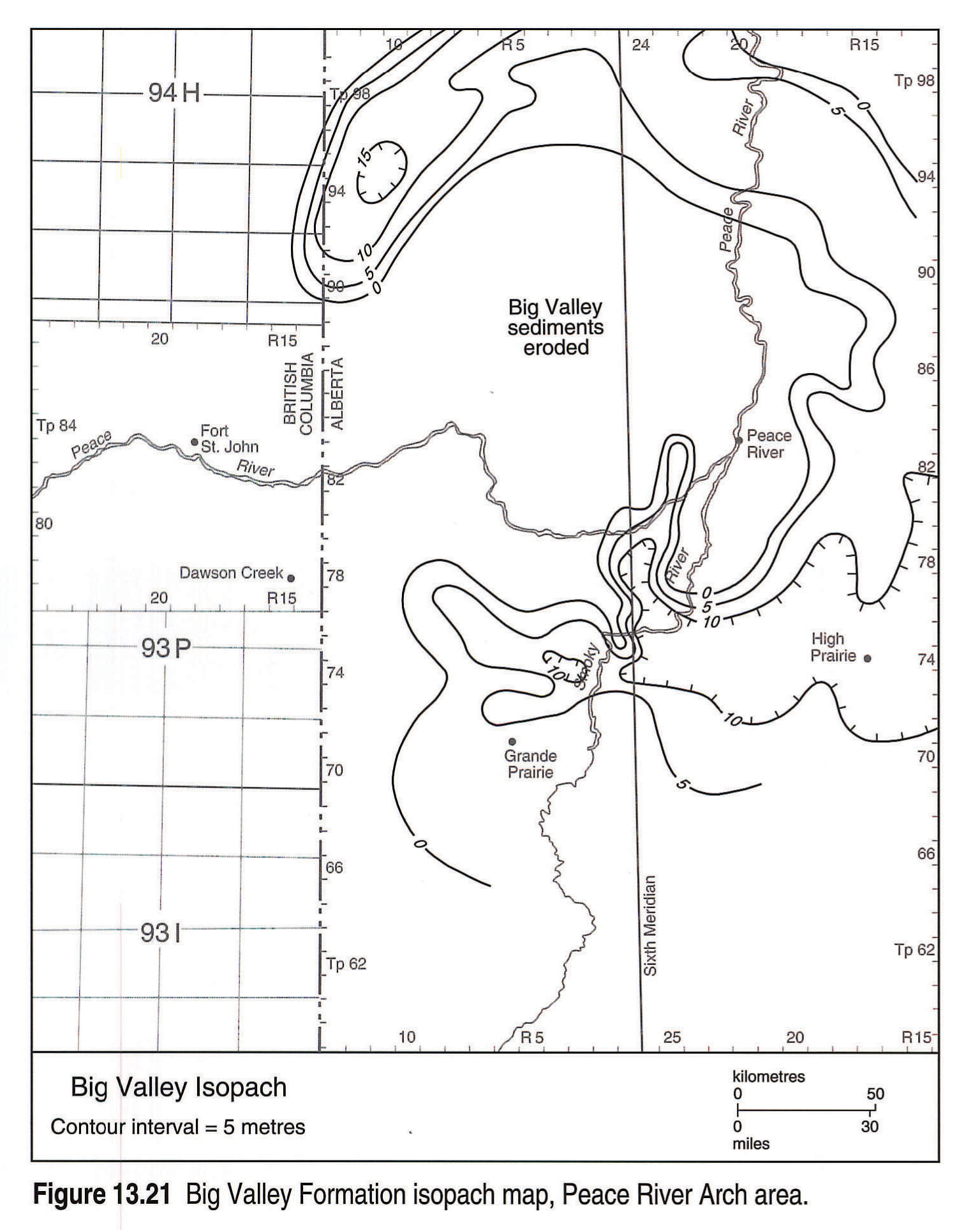
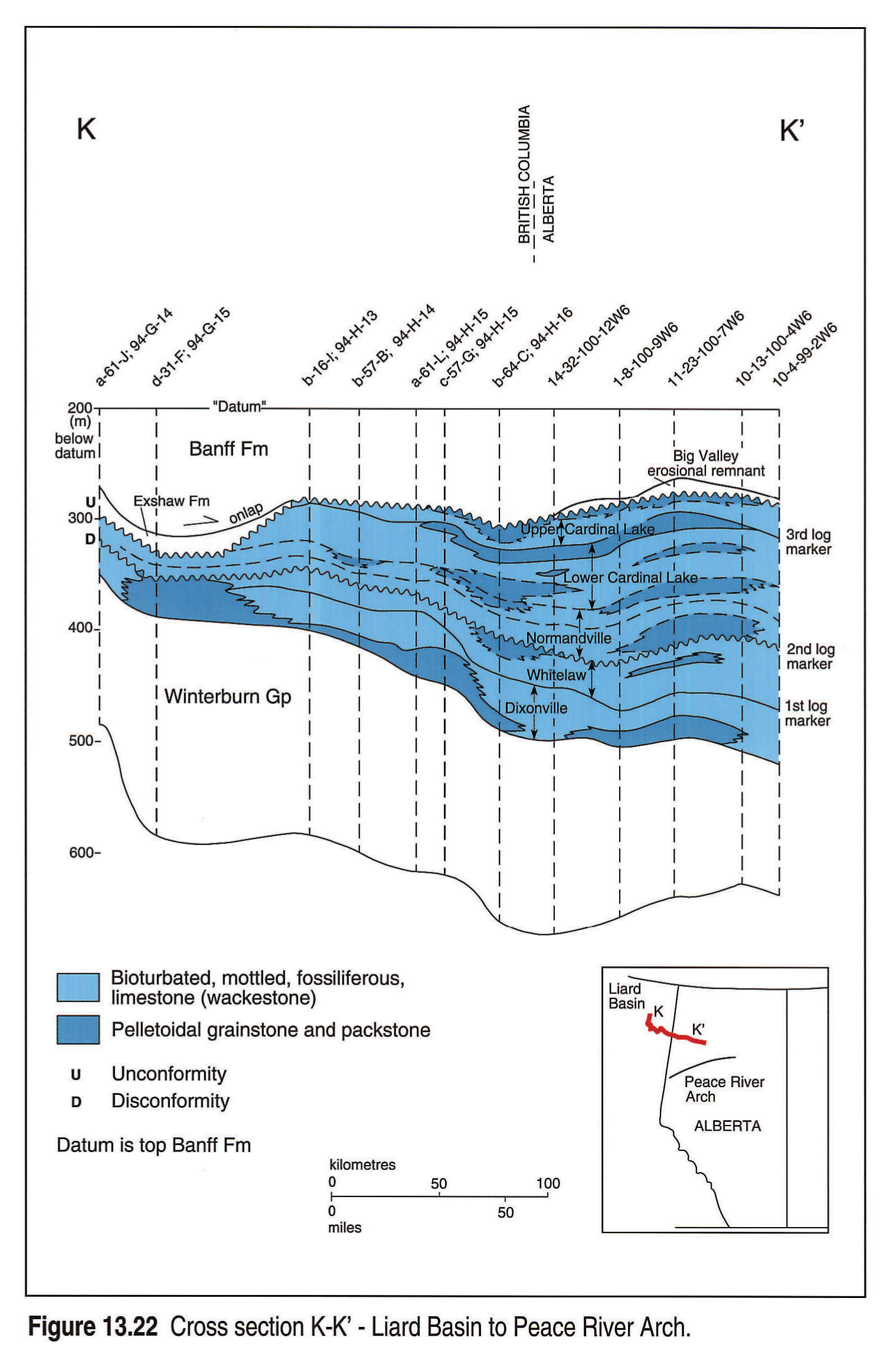
Evidence of later large-scale bevelling of the highstanding areas of the Peace River Arch is provided by some leaching and partial erosion of lower Cardinal Lake sediments.Figure 13.21 shows large-scale erosion of the overlying Big Valley Formation over most of the Arch area. Erosion of the Cardinal Lake and the Big Valley is also shown in the cross section from the Peace River Arch into the Liard Basin (Fig. 13.22). Of particular interest is the position of the Exshaw black shales infilling erosional lows.
Southern Alberta
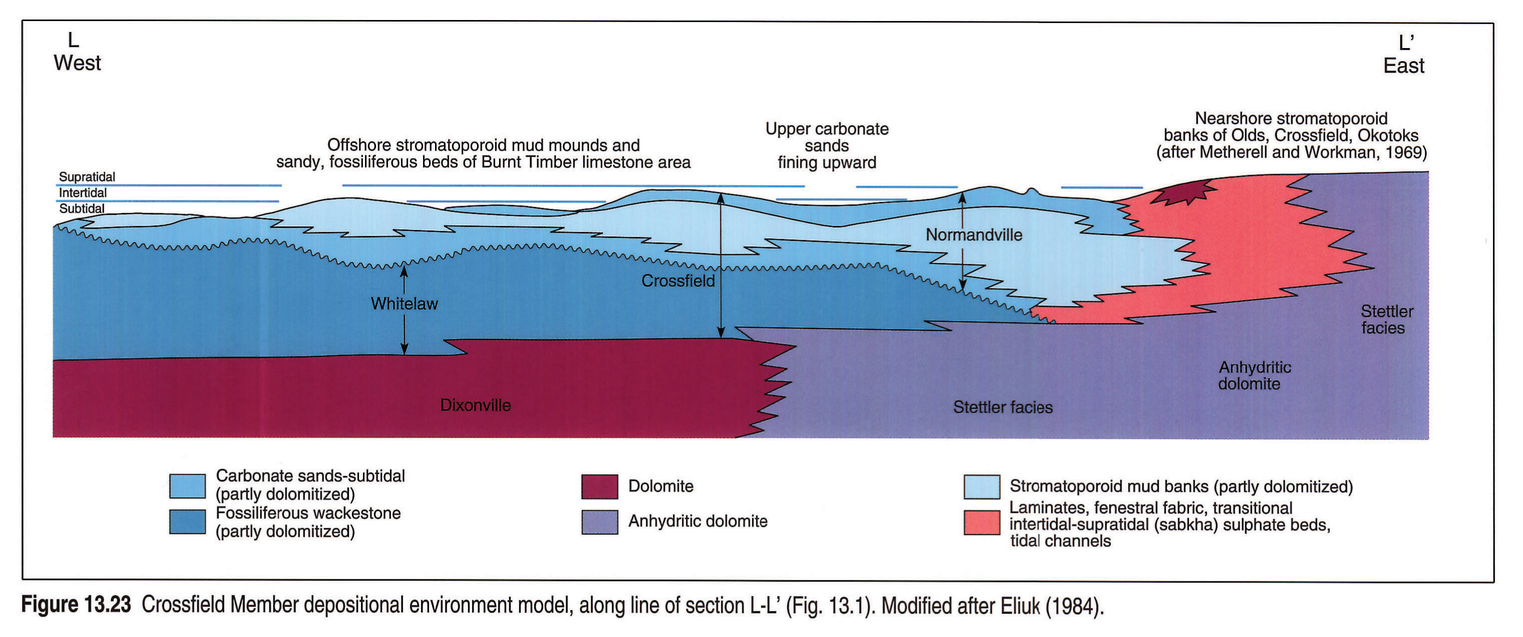
The depositional model and stratigraphy proposed by Eliuk (1984) for the Crossfield Member of southern Alberta includes a Whitelaw-Normandville wedge (Fig. 13.23). Eliuk (op. cit.) interpreted the burrowed Whitelaw wackestones as being the deepest water deposits of the Crossfield Member. An alternate interpretation is that these are restricted carbonates, transgressively overlapped by stromatoporoid mudbanks and grainstones of the Normandville. Marine erosion of the Whitelaw occurred prior to deposition of the stromatoporoid mud-mounds, forming an unconformity between the two units (see Fig. 13.23). For many years the two different facies in the Crossfield Member have been combined in one unit but the above interpretation suggests they are not related. The lower unit (Whitelaw) is regressive and restricted and the upper unit (Normandville) is transgressive and more open marine.
Regional Stratigraphic Cross Sections
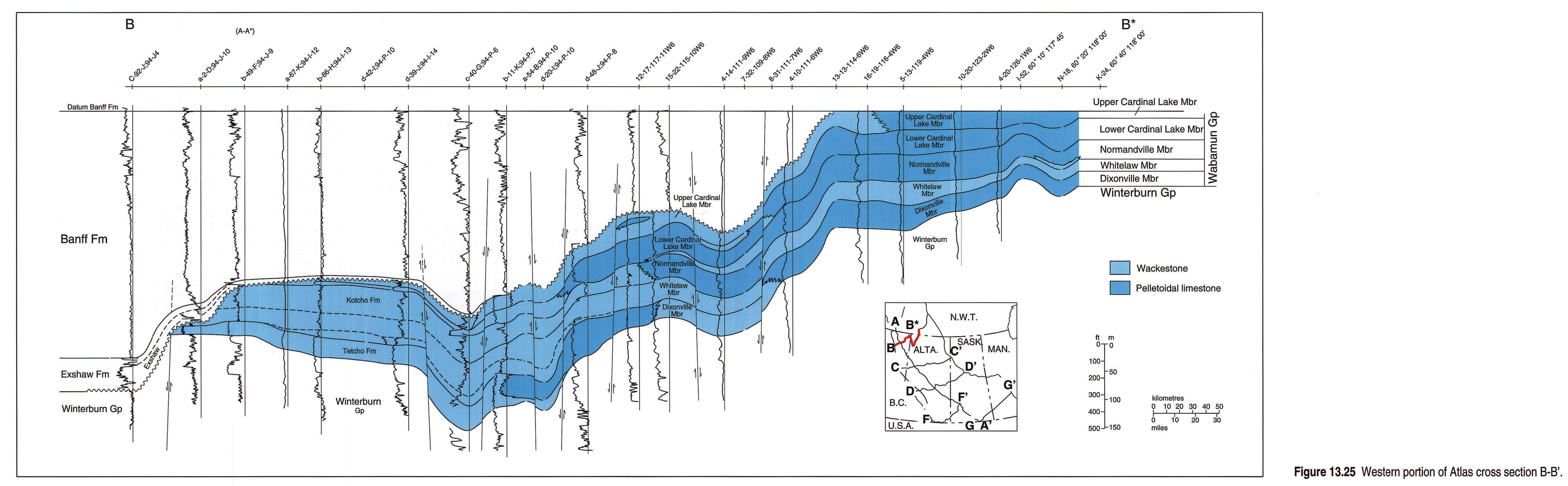
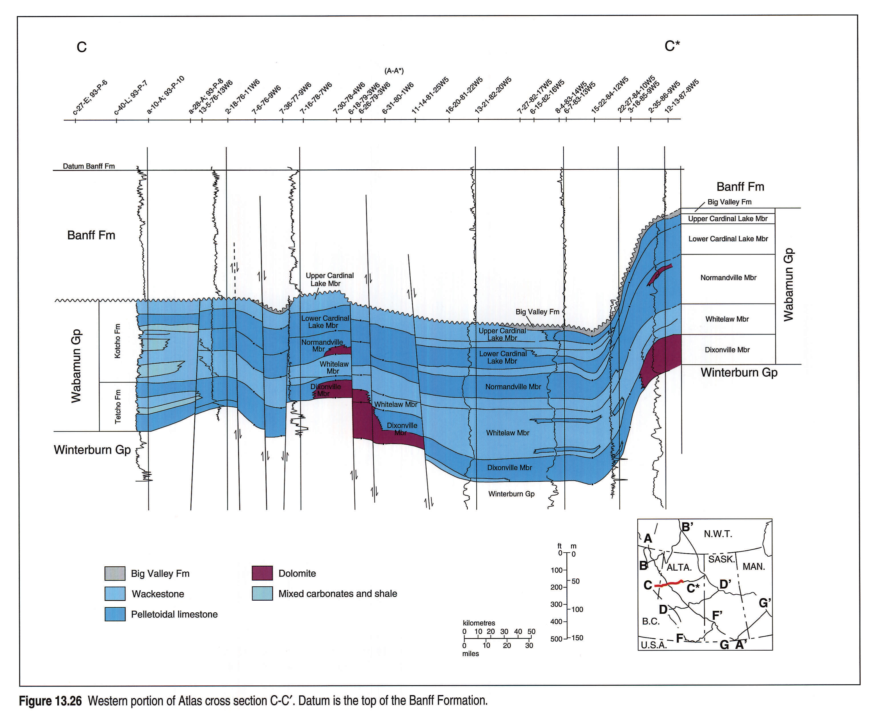
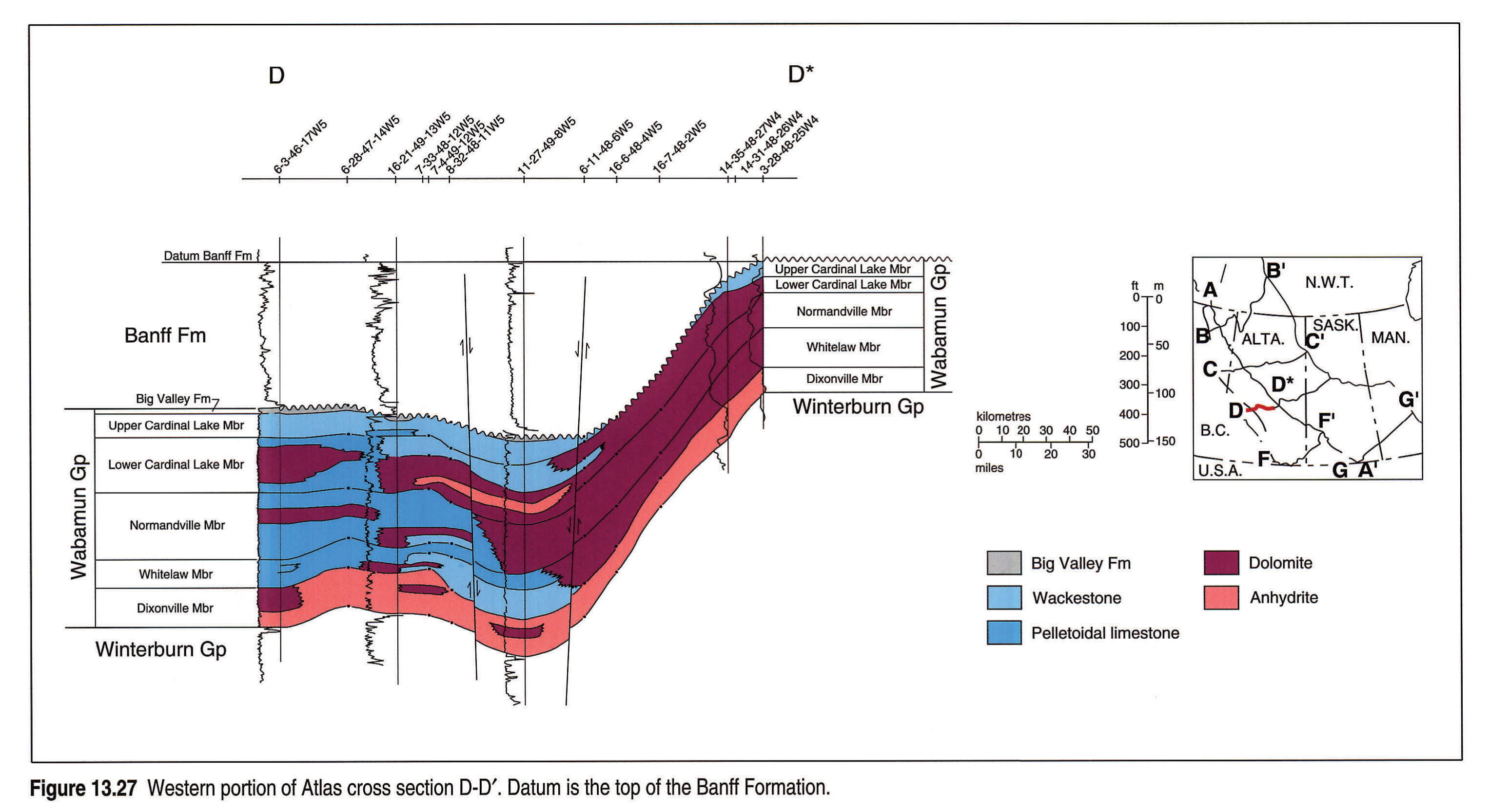
Four Atlas regional cross sections of the Wabamun depositional basin illustrate various lithological and stratigraphic relations of these Famennian sediments. The lithology in these sections, taken from Canstrat logs, is somewhat simplified. These sections are illustrated in Figures 13.24, 13.25, 13.26 and 13.27 (sections A-A* to D-D*) and their positions are shown in the general location map (Fig. 13.1).
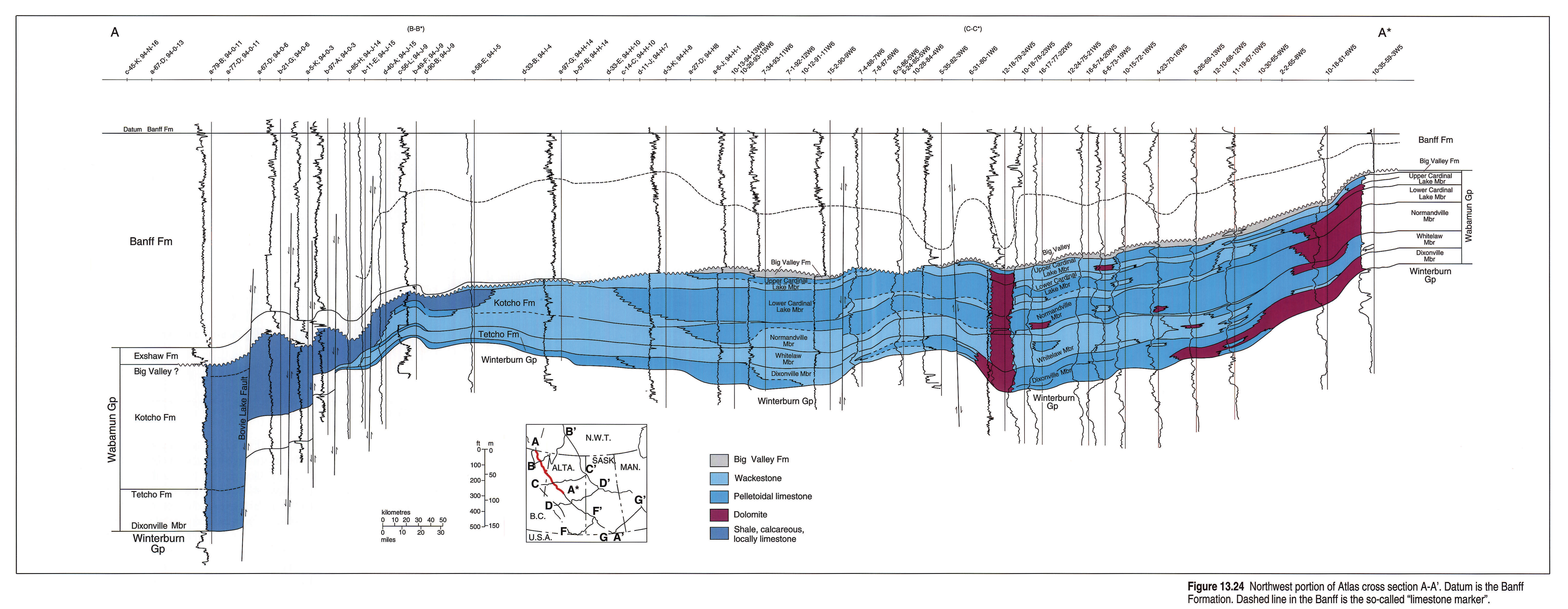
Cross section A-A* (Fig. 13.24), which extends from the Liard Basin to central Alberta, illustrates possible growth faulting with rapid subsidence on the Liard Basin slope. Thick sections of Tetcho deep-water lime mudstones and Kotcho shales were deposited, followed by accumulation of radioactive Exshaw black shales. The erosional unconformity at the top of the Big Valley, removing it over significant areas, is an important feature of the cross section. Erosion on the unconformity completely removed the Big Valley over significant areas, leaving the Banff Formation lying directly on upper Stettler strata. Although manifest only in the a-79-B/94-O-11 well, the contact of the Big Valley with the overlying Exshaw in the Liard Basin slope deposits also is considered to be unconformable.
Cross Section B-B* (Fig. 13.25) trends southwest-northeast and is oblique to strike. It illustrates transgressive onlap of Tetcho lime mudstones onto the Liard Basin slope and Dixonville grainstone deposition in the shelf areas. Of interest is the absence by erosion of Big Valley carbonates, and the lowstand deposition of radioactive Exshaw black shales infilling erosional depressions (cross sections Fig. 13.22 and B-B* Fig. 13.25).
Cross Section C-C* (Fig. 13.26) is a dip section in the Peace River Arch area. It illustrates considerable uplift to the west, in an area of the northern Rocky Mountains, where the upper Palliser is extensively eroded. Post-Wabamun basement faulting may have allowed the upflow of brines which dolomitized Palliser-Wabamun carbonates. A similar process may have taken place in the Smoky River Sub-basin to the east where horsts were dolomitized along southeast-northwest-trending tensional faults (Packard et al., 1992). Reservoirs created this way are fundamental to the Wabamun oil and gas plays in the Peace River area.
Cross Section D-D* (Fig. 13.27) illustrates the mainly dolomitic and anhydritic facies of the various members of the Stettler Formation in central Alberta. The Dixonville Member consists mainly of anhydrite but the overlying Whitelaw comprises a restricted facies with bioturbated wackestones at the base grading upward into peloidal grainstones. The Normandville Member consists mainly of peloidal grainstones and dolomite. Anhydrite and dolomite with bioturbated wackestones comprise the lower Cardinal Lake, but the upper section of this member consists entirely of bioturbated wackestones. Only small remnants of the partly eroded Big Valley Formation are preserved.
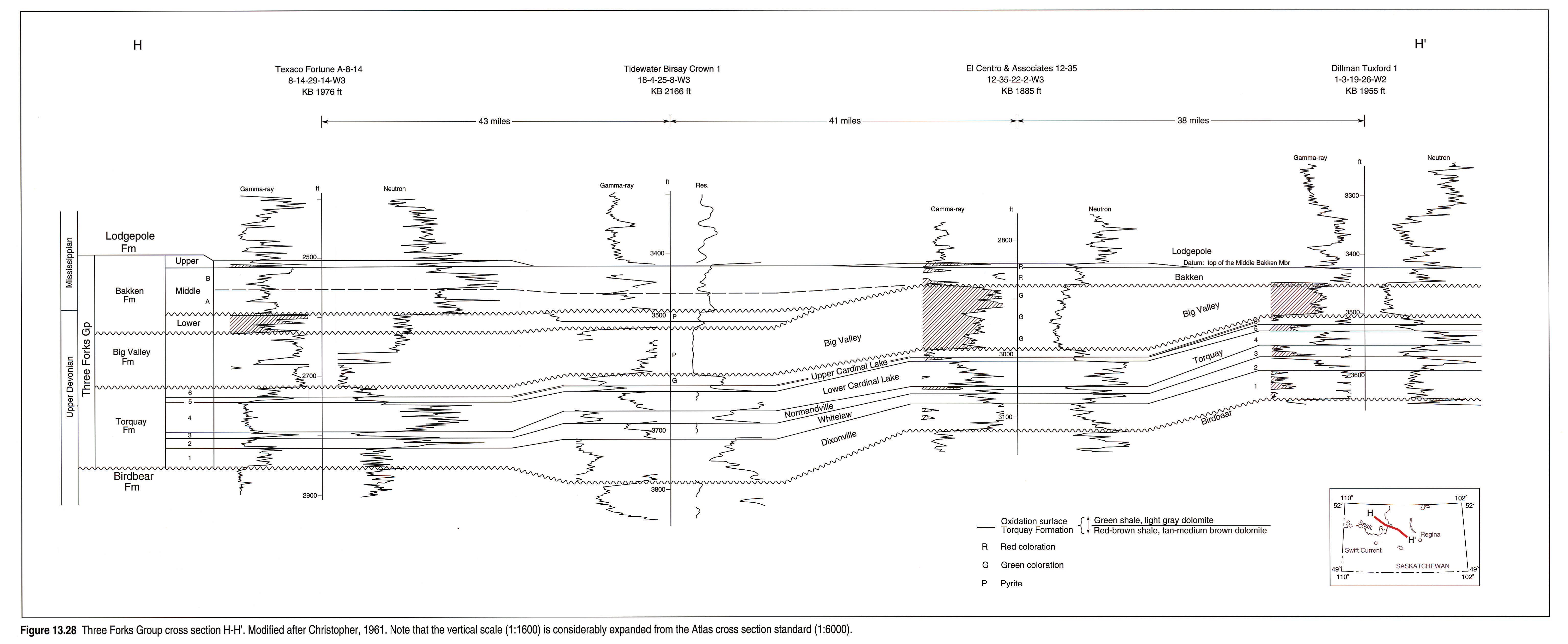
In Saskatchewan, Cross Section H-H' (Fig. 13.28) illustrates the subdivision of the Torquay Formation into six units (Christopher, 1961). These are extensively weathered sabkha-type silty dolomite and anhydrite facies separated by possible disconformities. Of interest are the varicolored to green-black noncalcareous shales of the Big Valley Formation, which probably were deposited in a tidal-flat environment but are similar to the overlying lower Bakken green and black shales.
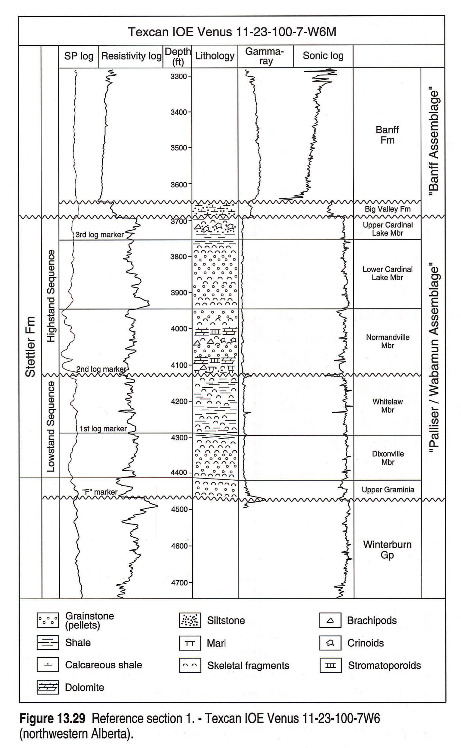
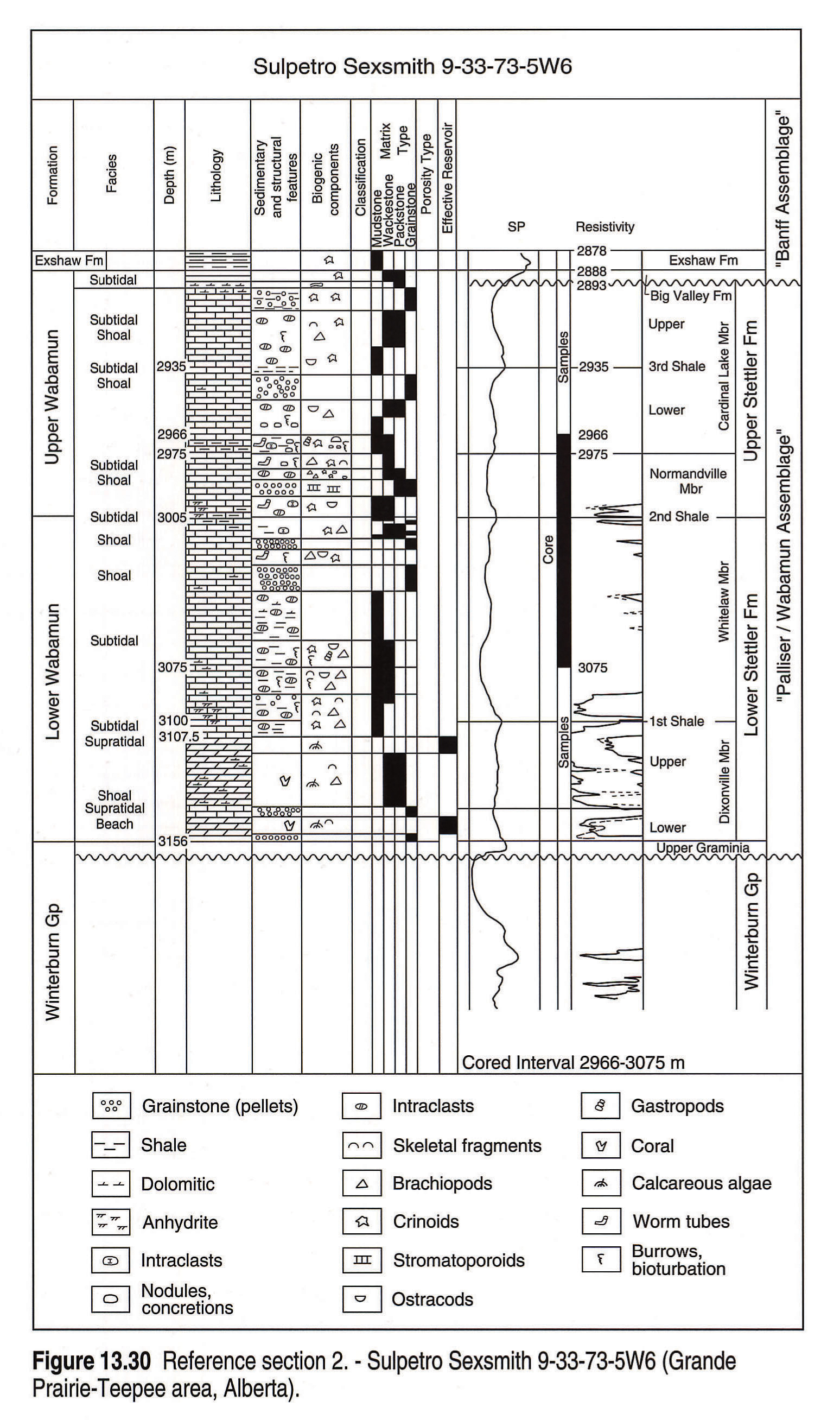
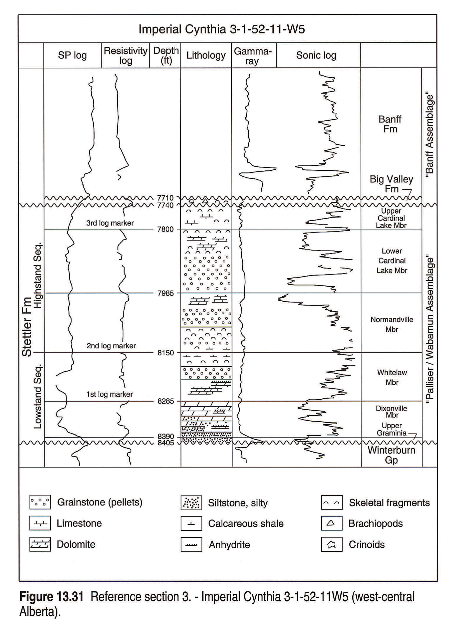
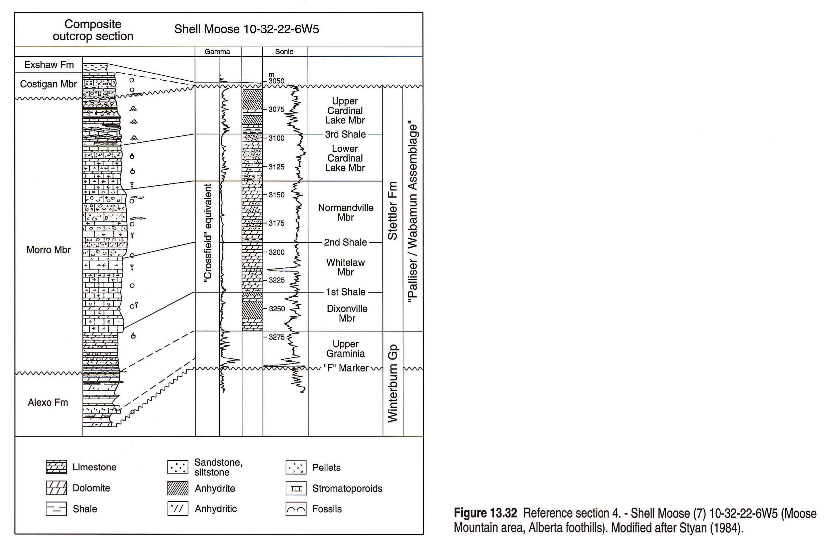
Well Reference Sections
Five well reference sections (numbered 1 to 5 on Figure 13.1) illustrate a variety of lithofacies representing the various depositional environments of the Wabamun. These sections are shown in Figures 13.29, 13.30, 13.31, 13.32, and 13.33.
Section 1 (Fig. 13.29) shows the muddy subtidal character of the Whitelaw and upper Cardinal Lake vertical accretion units. These are in direct contrast to the laterally progradational Dixonville and Normandville members, which comprise clean peloidal grainstones.
Section 2 (Fig. 13.30) shows shoaling grainstones and dolomite in the Dixonville. The thick Whitelaw contains very muddy fossiliferous carbonates, which are characteristic of the Smoky River Sub-basin. Most of the producing wells (Tangent, Teepee, etc.), which are on horsts at the northern limits of the basin, have this thick Whitelaw interval. Stromatoporoids and grainstones are common in the Normandville patch reefs (Nishida, 1987) and well developed in this borehole. Cardinal Lake strata are muddy with some local grainstone beds.
Section 3 (Fig. 13.31) represents the more evaporitic facies of the Dixonville and Whitelaw units in an area where dolomites and anhydrites are more common in the Wabamun. Grainstones are common in the Normandville and the lower Cardinal Lake units but the muddy upper Cardinal Lake and the fossiliferous, muddy Big Valley suggest very shallow-water environments.
The composite outcrop section by Styan (1984), Section 4, (Fig. 13.32) is correlated with a nearby foothills well, Shell Moose, 10-32-22-6W6. Facies in the Shell well are far more evaporitic than the outcrop section, which has more similarities with the Smoky River subsurface well (Fig. 13.30). In outcrop the Dixonville equivalent is dolomitic but in the Shell well is more evaporitic, with massive anhydrite. The restricted Whitelaw equivalent is muddy and lacks grainstones in outcrop but is very dolomitic in the Shell well. The resistant weathering of the transgressive Normandville equivalent in outcrop is due to the abundance of early cemented grainstones. Thin bedding characterizes the restricted Cardinal Lake equivalent limestones and dolomites in outcrop and is common in the upper parts of major regressive carbonate sequences (Wilson, 1975, p. 281). The Cardinal Lake unit in the Shell well contains regressive, massive anhydritic dolomite and anhydrite.
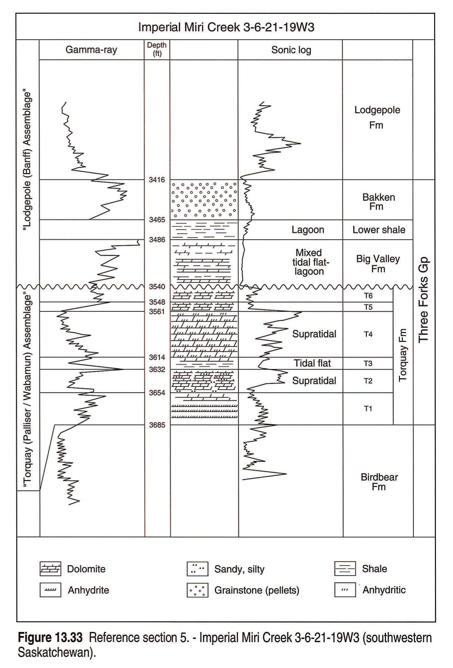
Section 5 (Fig. 13.33) illustrates Wabamun-equivalent stratigraphy and lithology in western Saskatchewan. The T3 shale unit in the middle of the Torquay Formation is probably the equivalent of the transgressive Normandville Member in Alberta. According to Christopher (1961), this green shale was widely deposited over the unconformity that separates T3 from the underlying T2 unit, during a transgressive pulse. The other five units in the Torquay are weathered, silty dolomites and anhydrites (regoliths), separated by disconformities (Christopher, 1961).
Stratigraphic Analysis
Geophysical well logs are amongst the most important tools available to the subsurface geologist. Both obvious and subtle log trace patterns, in conjunction with sample and core data, help define stratigraphic subdivisions, lithologies and depositional environments. Log characteristics of various Wabamun lithologies include: 1) high-energy deposits such as packstones and grainstones related to barrier and shoal environments of the Normandville Member, with higher than average porosity compared to other Wabamun carbonates, appear "clean" on the gamma-ray log, that is, they show a weak radioactivity of 10 API units maximum; 2) low-energy and restricted subtidal deposits, rich in micrite and clay, such as the Whitelaw and upper Cardinal Lake members are "dirtier" on the gamma-ray log, with radioactivity readings varying between 10 and 40 API units.
Regional gamma-ray markers form the basis for correlation of units. In the shallower parts of the basin these regional markers occur at the base of the Whitelaw, Normandville, upper Cardinal Lake and Big Valley units. In the more open-marine part of the basin, however, where the carbonates are cleaner, these marker beds are less obvious (Meijer Drees and Geldsetzer, 1984). Here the use of shelf-potential logs is more effective for correlation purposes (Fig. 13.29). Shale breaks indicate slightly regressive, normally lagoonal conditions and the unit boundaries are picked at the highest gamma-ray and lowest self-potential readings (maximum organic matter).
Depositional Analogue
Depositional sequences in the Stettler Formation of the Western Canada Sedimentary Basin closely resemble the middle Cretaceous Mishrif Formation of the Middle East (Reulet, 1982, p. 165-173). The Mishrif Formation is a regressive carbonate sequence underlain by basinal facies and capped by a regional unconformity. It can be subdivided into two sequences, both of which have a transgressive-regressive couplet: 1) the basal sequence, which ranges from open marine to restricted lagoonal; and 2) the upper sequence, composed of outer shelf deposits overlain by inner shelf deposits. A sedimentary discontinuity apparently separates the two sequences. The basal sequence is similar to the transgressive-regressive Tetcho-Lower Kotcho sequence at the Liard Basin slope or the transgressive-regressive Dixonville-Whitelaw sequence on the shelf. The upper sequence, however, is similar to the transgressive-regressive Normandville-Cardinal Lake sequence on the outer and inner shelves.
As a result of extensional blockfaulting, sedimentation of the Mishrif carbonates was more heterogeneous than that of the Stettler. Subaerial removal and leaching of carbonates associated with the regional unconformity capping the Mishrif was significant and created excellent reservoir conditions, not matched in the Stettler (Harris et al., 1984).
Regional Biostratigraphy and Correlations
Correlation of Palliser/Wabamun rocks with age-equivalent units in the United States is handicapped by lack of faunal evidence in Canada, conodonts in particular. Recently, efforts have been made by Richards et al. (1991) and Meijer Drees and Johnston (1992) to rectify this problem. Derived from conodont zones, their correlations, based on the work of Sandberg et al. (1988), are illustrated in Fig. 13.34.
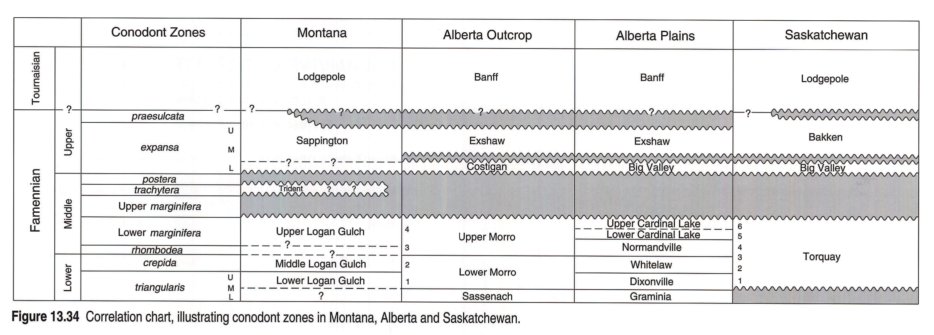
The following is a summary of the main points of biostratigraphic correlation issues relating the Famennian of Canada to apparent counterparts in the United States.
In the United States, the Middle triangularis Zone is regarded as the beginning of the first Famennian transgression. Although in Canada conodonts have not been found in the lower Morro Member (unit 1 of Meijer Drees and Johnston, 1992) or the lower Dixonville Member, it is possible that they correlate with the lower Logan Gulch Member (Three Forks Formation).
The Middle Logan Gulch Member in Montana contains the crepida Zone and correlates with the Whitelaw Member in the subsurface of Alberta and unit 2 of the Palliser Formation (lower Morro) of Meijer Drees and Johnston (1992).
In the United States, rocks of the Lower marginifera Zone of Sandberg et al. (1988, p. 202) record a significant global rise in sea level, the "second Famennian transgression" of Sandberg et al. (1988). Correlatable formations in this zone include the upper part of the Logan Gulch Member in Montana, which correlates with the Normandville Member of the Stettler Formation and the lower part of the upper Morro Member of the Palliser Formation in Canada. Meijer Drees and Johnston (1992) reported that the latter unit, which correlates with their unit 3 of the Palliser, contains Lower rhomboidea to Lower marginifera zones. Stromatoporoid mud-mounds in the Normandville (upper part of the Crossfield Member) in southern Alberta have their counterpart in similar mud-mounds in the age-equivalent Guilmette Formation in northwestern Nevada (Sandberg et al., 1988, p. 202) and in Belgium (Dreesen et al., 1985).
The interbedded dolostones, carbonate breccias, laminated and silty limestones, and stromatolitic limestones of unit 4 (Meijer Drees and Johnston, 1992) probably correlate with the Cardinal Lake Member of the Stettler; however, no conodonts have been found in the latter to confirm the correlation.
The uppermost marginifera Zone has not been recognized in the United States and Canada, probably because of continent-wide erosion. According to Sandberg et al. (1988) this erosion was interrupted by a transgression (trachytera Zone) which is postulated to be represented by the Trident Member of the Three Forks Formation in Montana. However, this conodont zone is identified only in offshore marine sections in Utah, Idaho and Arizona. Supporting biostratigraphic documentation is provided only by brachiopods which, according to Raasch (1988), have a longer time span than conodont zones. In Canada the trachytera Zone is not present (Richards et al., 1991). This suggests that the unconformity between the Morro/Stettler and the Costigan/Big Valley is of significant magnitude in the Western Canada Sedimentary Basin. In Canada, only the upper few metres of what was originally identified as the Costigan Member of the Palliser correlates with the Big Valley Formation in the subsurface. These are highly fossiliferous and argillaceous gray limestones that have no affinity with the underlying interbedded dolostones and laminated and silty limestones, which are most likely of uppermost Morro equivalents (Wonfor and Andrichuk, 1956, p. 106; Richards et al., 1991). In the Trident type section at Logan, Montana, the upper 15 m are greenish gray fossiliferous shale and fossiliferous argillaceous limestone. At the bottom are 7 m of silty dolomite and dolomitic limestone (Sandberg, 1965, p. N13). The type section at Logan either was not searched for conodonts or did not yield any, but it is suggested that only the upper 15 m correlate with the Big Valley and the lower 7 m belong to the Logan Gulch.
According to Richards et al. (1991), both the Costigan/Big Valley and the overlying Exshaw are within the expansa Zone. In the United States only the Sappington Member of the Three Forks, which correlates with the Exshaw and Bakken formations in Canada, is identified as containing the Lower expansa Zone (Sandberg et al., 1988, p. 206).
Richards et al. (1991, p. 53) included the Famennian Exshaw in the "Banff assemblage", because of its shallow-neritic to supratidal siliciclastic affinity with the overlying Banff Formation. I propose that the Costigan/Big Valley units also be added to the "Banff assemblage" for the same reason. They not only unconformably overlie the Morro/Stettler strata but apparently contain the same expansa Zone as the overlying Exshaw/Bakken formations. Furthermore, the Big Valley shales in Saskatchewan are practically identical to the overlying lower Bakken shales.
Structure and Hydrocarbon Occurrences
Structure
A structure map of the top of the Wabamun Group is displayed in Figure 13.35. The marked southwest structural dip component in the subsurface is a result of depression of the foreland basin and underlying cratonic platform strata by tectonic loading during the Late Cretaceous and early Tertiary.
Structurally high areas are preserved north of the Peace River Arch and along the Sweetgrass Arch in Southern Alberta. These areas possibly reflect pre-Middle Devonian compressive deformation due to a thinner crust (high Moho; see Ross and Stephenson, 1989). Further evidence of this deformation is provided by extensive northeast-southwest transverse faulting in the area of the Peace River Arch (Sikabonyi and Rogers, 1959).
Hydrocarbon Occurrences
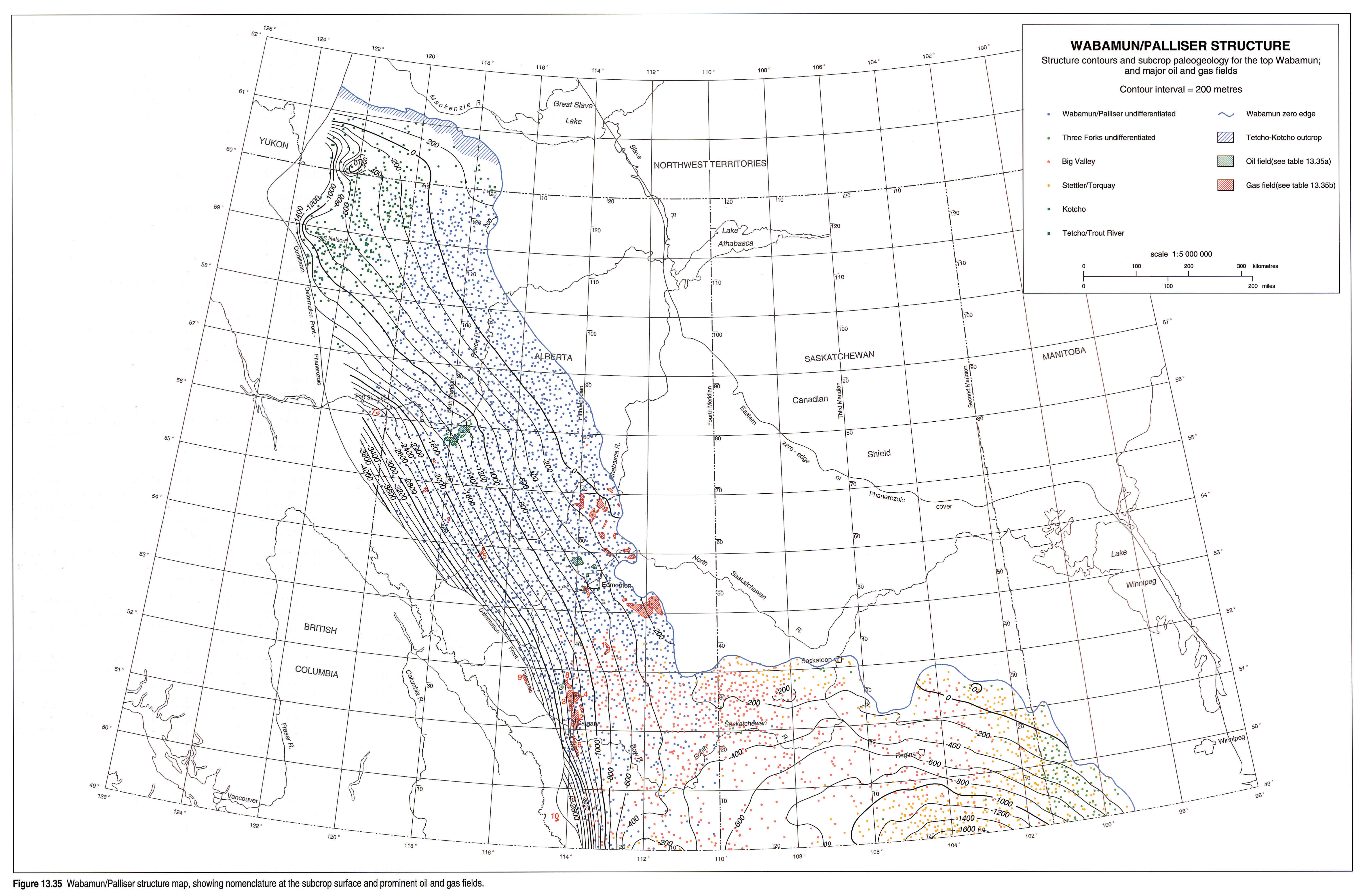
Commercial production of oil and gas from rocks of the Wabamun Group comes largely from Alberta. Locations of the major oil and gas fields are set out in Figure 13.35.
Gas fields with the largest reserves are those associated with stratigraphic entrapment in the Crossfield Member. The Crossfield productive trend extends from Olds to Okotoks in the southern Alberta plains and is parallel to the main facies trends in the area (Figs. 13.3 and 13.4). Sour gas is trapped in moldic and vuggy porosity occurring in dolomitized stromatoporoid mounds and gastropod muds. Updip seals are provided by nonporous evaporitic dolomites and anhydrites (McNamara and Wardlaw, 1992). The positioning of mounds is closely related to maximum tidal erosion of the Whitelaw substratum at the foreshore (Fig. 13.23).
The paleo-high in the Edmonton area between latitudes 52 and 54°N, illustrated on the Wabamun/Palliser isopach and lithofacies map (Fig. 13.3), appears to define the dry gas productive trend of subcrop traps. These fields are formed by pre-Cretaceous truncation of the older sediments. Gas is trapped in interpeloidal and dolomite-associated porosity, sealed by overlying impermeable Mesozoic sediments.
In the southern Alberta Foothills the Wabamun is involved in thrusting. Where dolomitized (most of the reservoirs are associated with the Crossfield Member) and in structural closure, these traps make good fields, especially where permeability is enhanced by fracturing.
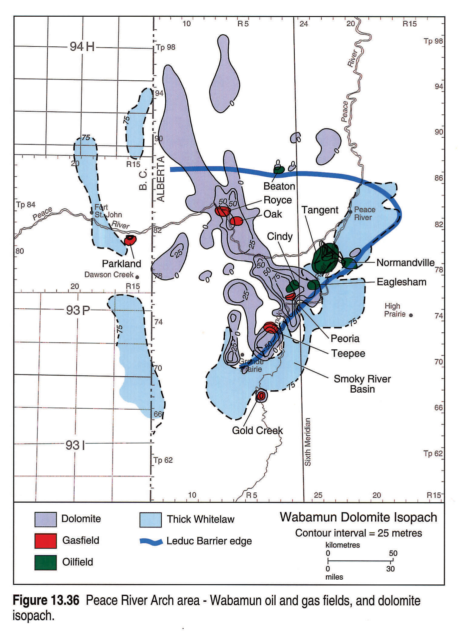
In the Peace River Arch area, Wabamun oil and gas fields occur in, and are associated with, faulted horst structures. These features occur at the northern edge of the Smoky River Sub-basin, broaching the crestal portions of the Peace River Arch (Fig. 13.36). Most reservoirs occur in fault-controlled, hydrothermal, white dolomites (Stoakes, 1987; Packard and Pellegrin, 1989). Two dominant fault trends can be recognized in this area: northwest-trending synthetic extension faults with hangingwall movement down to the southwest, but possibly linked at depth with a detachment extending to the continental margin (see also McClay et al., 1989), and northeast-southwest transverse faults, possibly associated with compression (Churcher and Majid, 1989). The tension faults were involved in the formation of the extensional Peace River rift basin (Peace River Embayment) after Wabamun deposition. Movement of the hangingwall allowed hot, magnesium-rich, dolomitizing fluids to rise and penetrate Wabamun limestones, in particular Normandville grainstones (Packard et al., 1992; Halim-Dihardja and Mountjoy, 1992). However, the present-day disposition of Wabamun oil and gas fields is probably the result of inversion of the Peace River basin in Laramide time by reactivation of the extensional fault system in contraction. Similar tectonics possibly created the Parkland gas field (Figs. 13.10 and 13.36) at the western edge of the Peace River Arch in northeast British Columbia.
Discussion
The stratigraphic history of Stettler carbonates indicates that eustatic sea-level fluctuations had a major influence on sedimentation rates. Grainstones and other clean carbonates deposited during rapid build-up relate to transgression, whereas argillaceous carbonate and shale lithologies represent periods of slower deposition during regression or transition. During the first Famennian transgression (Sandberg et al., 1988) Tetcho carbonates covered much of the Hay River outer shelf (Liard Basin slope), at about the same geographic position as the carbonates of the upper Frasnian Kakisa Formation (Morrow and Geldsetzer, 1988). These Tetcho rocks interfinger up-ramp with the Dixonville inner shelf carbonates, the lowest unit of Palliser-Wabamun strata. Overlying regressive lower Kotcho calcareous siliciclastics on the outer shelf interfinger with restricted argillaceous Whitelaw carbonates on the inner shelf.
During the following and most important highstand, brought on by the second Famennian transgression of Sandberg et al. (1988), Normandville-Cardinal Lake shelf carbonates produced platform-like systems, characterized by rapid build-up. Consisting mainly of prograding, shoaling grainstones, these sediments bear remarkable similarity to the Mishrif model of Reulet (1982, p. 169).
On the comparatively open carbonate shelf in northern and western Alberta, the Stettler succession conforms very well to Wilson's (1975, p. 281) model for carbonate shelf cycles. Farther east, where carbonate and evaporite deposits intermingle, the succession reflects persistently hot and dry climatic conditions, in a system that reacted sensitively to intermittent sea-level fluctuations. On the innermost shelf, in southeastern Alberta and Saskatchewan, the succession is dominated by stacked supratidal facies. All of the Stettler evaporite-carbonate-shale sequences thus have a similar history, but they were developed at different positions on the platform.
The pyritic, gray, argillaceous, Costigan/Big Valley limestones and shales unconformably overlie the Stettler succession and appear to have little real affinity to it. Indeed, Big Valley lithologies and depositional environments appear to be more akin to clastics and carbonates of the overlying Exshaw-Banff and Bakken-Lodgepole successions ("Banff assemblage" of Richards et al., 1991, p. 53). In particular the noncalcareous, varicolored and green and black shale facies of the Big Valley in the Williston Basin are, according to Christopher (1961), very similar to the overlying noncalcareous Lower Bakken (Macqueen and Sandberg, 1970).
Because of their lack of evaporites, Costigan/Big Valley strata were considered to represent highstand transgression (Andrichuk, 1960; Richards, et al., 1991). An alternative model involves lowstand conditions, with the most pyritic black shales deposited in stagnant and anoxic environments on the confined shelf. Volcanic activity, as evidenced by bentonites in the Saskatchewan Big Valley, may have contributed to the anoxia.
In summary, Palliser/Wabamun strata represent two different major stratigraphic sequences: a lowstand-highstand carbonate sequence (Stettler Formation) reacting to an intermittently rising relative sea level, unconformably overlain by the basal lowstand unit (Big Valley Formation) of the siliciclastic-carbonate Banff assemblage.
Acknowledgements
I wish to thank I.A. McIlreath for his continuous interest and support in this study. I also thank J.E. Barclay and N.C. Meijer Drees for thoroughly editing an earlier version of the manuscript. The final manuscript benefitted from constructive reviews by I.A. McIlreath, L. Terberg and in particular M. Leith, who made several helpful suggestions for improvement of text.
Katy Ma-Mckercher produced the Stettler and Big Valley computer lithomaps, using Canadian Stratigraphic Services digital data files. The Big Valley cross section from Alberta into Saskatchewan was made by L. Terberg. R.S. Nishizaki of Canadian Stratigraphic Service Ltd. gave generous support with access to stratigraphic log files and use of facilities. Pat Warners and Dona Becker of Petro-Canada drafted many of the original figures and maps. Word processing of the manuscript by Mrs. Stacey McGinnis of McLeay Geological Consultants (1986) Ltd. is also very much appreciated.
References
- Alberta Petroleum and Natural Gas Conservation Board, 1956. Schedule of Wells Drilled for Oil an Gas in 1956, p. 12.
- Andrichuk, J.M. 1960. Facies analysis of Upper Devonian Wabamun Group in west-central Alberta. American Association of Petroleum Geologists, v. 44, p. 1651-1681.
- Beales, F.D. 1956. Conditions of deposition of Palliser (Devonian) limestone of southwestern Alberta. American Association of Petroleum Geologists, Bulletin, v. 40, p. 848-870.
- Belyea, H.R. 1964. Upper Devonian Wabamun Group. In: Geological History of Western Canada. R.G. McCrossan and R.P. Glaister (eds.). Calgary, Alberta Society of Petroleum Geologists, p. 848-870.
- Belyea, H.R. and McLaren, D.J. 1962. Upper Devonian formations, southern part of Northwest Territories, northeastern British Columbia and northwestern Alberta. Geological Survey of Canada, Paper 62-15, 82 p.
- Burwash, R.A., McGregor, C.R., and Wilson, J.A. (this volume). Precambrian basement beneath the Western Canada Sedimentary Basin. In: Geological Atlas of the Western Canada Sedimentary Basin. G.D. Mossop and I. Shetsen (comps.), Calgary, Canadian Society of Petroleum Geologists and the Alberta Research Council, chpt. 5.
- Christopher, J.E. 1961. Transitional Devonian-Mississippian formations of southern Saskatchewan. Saskatchewan Department of Mineral Resources, Report 66, 103 p.
- Churcher, P.L. and Majid, A.H. 1989. Similarities between the Tangent-Wabamun type play of the Alberta Basin and Albion-Scipio type play of the Michigan Basin. Bulletin of Canadian Petroleum Geology, v. 37, p. 241-245.
- de Wit, R. and Mclaren, D.J. 1950. Devonian sections in the Rocky Mountains between Crowsnest Pass and Jasper, Alberta. Geological Survey of Canada, Paper 50-23, 66 p.
- Dreesen, R., Bless, M.J.M., Conil, P., Flajs, G., and Lacket, C. 1985. Marbre rouge a crinoides de Bakken (Late Upper Devonian, Verviers Synclonorium, Eastern Belgium). Societe Geologique de Belgique Annales, v. 108, p. 311-359.
- Eliuk, L.S. 1984. A hypothesis for the origin of hydrogen sulfide in Devonian Crossfield Member dolomite, Wabamun Formation, Alberta. In: Carbonates in Subsurface and Outcrop. L.S. Eliuk (ed.). Canadian Society of Petroleum Geologists, 1984 Core Conference, p. 225-244.
- Geldsetzer, H.H.J. 1982. Depositional history of the Devonian succession in the Rocky Mountains southwest of the Peace River Arch. In: Current Research, Part C, Geological Survey of Canada, Paper 82-1C, p. 55-64.
- Halbertsma, H.L. and Meijer Drees, N.C. 1987. Wabamun limestone sequences in north-central Alberta. In: Devonian Lithofacies and Reservoir Styles in Alberta. F.F. Krause and O.G. Burrowes (eds.). Second International Symposium on the Devonian System, Core Conference Guide. Canadian Society of Petroleum Geologists, Calgary, p. 21-37.
- Halim-Dihardja, M.K. and Mountjoy, E.W. 1992. Fracture and fault-controlled burial dolomitization, Late Devonian Wabamun Group, Alberta (Abstract). American Association of Petroleum Geologists, 1992 Annual Convention, Calgary, Alberta, Canada. p. 83.
- Harris, P.M., Frost, S.H., Seiglie, G.A., and Schneidermann, N. 1984. Regional unconformities and depositional cycles, Cretaceous of the Arabian Peninsula. In: Interregional Unconformities and Hydrocarbon Accumulation. American Association of Petroleum Geologists, Memoir 36, p. 67-80.
- Kents, P. 1959. Three Forks and Bakken stratigraphy in west-central Saskatchewan. Department of Mineral Resources, Saskatchewan, Report 37, p. 37.
- McClay, K.R., Insley, M.W., and Anderton, R. 1989. Inversion of the Kechika Trough, northeastern British Columbia, Canada. In: Inversion Tectonics. M.A. Cooper and G.D. Williams (eds.). Geological Society Special Publication No. 44. p. 235-257.
- Macqueen, R.W. and Sandberg, C.A. 1970. Stratigraphy, age and inter-regional correlation of the Exshaw Formation, Alberta Rocky Mountains, Bulletin of Canadian Petroleum Geology, v. 18, p. 32-66.
- McNamara, L.B. and Wardlaw, N.C. 1992. Reservoir Description of the Crossfield Member of the Wabamun Group, Western Canada (Abstract). American Association of Petroleum Geologists, 1992 Annual Convention, Calgary, Alberta, Canada. p. 87.
- Meijer Drees, N.C. and Geldsetzer, H.H.J. 1984. Correlation between Upper Devonian surface and subsurface map units in west-central Alberta. In: Current Research, Part B, Geological Survey of Canada, Paper 84-1B, p. 337-349.
- Meijer Drees, N.C. and Johnston, D.I. 1992. The Upper Devonian Palliser and Wabamun formations in Alberta, Canada (Abstract). American Association of Petroleum Geologists, 1992 Annual Convention, Calgary, Alberta, Canada. p. 87.
- Metherall, R.G. and Workman, L.E. 1969. Sedimentary features of the Crossfield Member. Bulletin of Canadian Petroleum Geology, v. 17, p. 444-459.
- Moore, P.F. 1989. The Kaskaskia Sequence: reefs, platforms and foredeeps. The Lower Kaskaskia Sequence - Devonian. In Western Canada Sedimentary Basin, A Case History. B.D. Ricketts (ed.). Calgary, Canadian Society of Petroleum Geologists, p. 139-164.
- Morrow, D.W. and Geldsetzer, H.H.J. 1988. Devonian of the Eastern Cordillera. In: Devonian of the World. Proceedings of the Second International Symposium on the Devonian System, Calgary, Volume I, p. 85-121.
- Nishida, D.K. 1987. A Famennian stromatoporoid patchreef in the Wabamun Group, west-central Alberta. In: Devonian Lithofacies and Reservoir Styles in Alberta. F.F. Krause and O.G.Burrowes (eds.). 13th Canadian Society of Petroleum Geologists Core Conference. Canadian Society of Petroleum Geologists, p. 63-72.
- Packard, J.J. and Pellegrin, G. 1989. Diagenesis and dolomitization associated with hydrothermal karst in Famennian Upper Wabamun ramp sediments, northwest Alberta. In The Development of Porosity in Carbonate Reservoirs. G.R. Bloy, M.G. Hadley and B.V. Curtis (eds.). Canadian Society of Petroleum Geologists, Calgary. Continuing Education Short Course Notes, Section 8.
- Packard, J.J., Churcher, P., Samson, I., Spencer, R., and Majid, A.H. 1992. Hydrothermal karstification and dolomitization of Upper Devonian (Wabamun Group) medial ramp limestones, north-central Alberta, Canada (Abstract). American Association of Petroleum Geologists, 1992 Annual Convention, Calgary, Alberta, Canada. p. 100.
- Raasch, G.O. 1988. Famennian faunal zones in Western Canada. In: Devonian of the World. Proceedings of the Second Inter- national Symposium on the Devonian System, Calgary. N.J. McMillan, A.F. Embry and D.J. Glass (eds.). Volume III, p. 619-629.
- Reeckmann, A. and Friedman, G.M. 1982. Exploration for carbonate petroleum reservoirs. John Wiley and Sons, New York, 213 p.
- Reulet, J. 1982. Carbonate reservoirs in a marine shelf sequence, Mishrif Formation, Cretaceous of the Middle East. In: A. Reeckmann and G.M. Friedman. Exploration for Carbonate Petroleum Reservoirs, New York, John Wiley & Sons, p. 165-173.
- Richards, B.C. 1989. Upper Kaskaskia Sequence: uppermost Devonian and Lower Carboniferous. In: Western Canada Basin, A Case History. B.C. Ricketts (ed.). Canadian Society of Petroleum Geologists, Calgary, p. 165-201.
- Richards, B.C., Henderson, C.M., Higgins, A.C., Johnston, D.I., Mamet, B.L., and Meijer Drees, N.C. 1991. The Upper Devonian (Famennian) and Lower Carboniferous (Tournaisian) at Jura Creek southwestern Alberta. Canadian Society of Petroleum Geologists Field Excursion, August 29, 1991.
- Ross, G. and Stephenson, R.A. 1989. Crystalline basement, the Foundation of Western Canada Sedimentary Basin. In: Western Canada Sedimentary Basin, A Case History. B.D. Ricketts (ed.). Canadian Society of Petroleum Geologists, p. 33-45.
- Sandberg, C.A. 1965. Nomenclature and correlation of lithologic subdivisions of the Jefferson and Three Forks formations of southern Montana and northern Wyoming. U.S. Geological Survey, Bulletin 1194 N., p. N.1-18. (Contributions to Stratigraphy).
- Sandberg, C.A., Poole, F.G., and Johnson, J.G. 1988. Upper Devonian of western United States. In: Devonian of the World. Proceedings of the Second International Symposium on the Devonian System, Calgary. N.J. McMillan, A.F. Embry and D.J. Glass (eds.). Volume I, p. 183-220.
- Sikabonyi, L.A. and Rodgers, W.J. 1959. Paleozoic tectonics and sedimentation in the northern half of the West Canadian Basin. Journal of the Alberta Society of Petroleum Geologists, v. 7, no. 9, p. 193-216.
- Stoakes, F.A. 1980. Nature and control of shale basin fill and its effect on reef growth and termination: Upper Devonian Duvernay and Ireton Formations of Alberta, Canada. Bulletin of Canadian Petroleum Geology, v. 28, No. 3, p. 345-410.
- Stoakes, F.A. 1987. Fault controlled dolomitization of the - Wabamun Group, Tangent Field, Peace River Arch, Alberta. In: Devonian Lithofacies and Reservoir Styles in Alberta. F.F. Krause and O.G. Burrowes (eds.). 13th Canadian Society of Petroleum Geologists Core Conference. Canadian Society of Petroleum Geologists, Calgary, p. 73-85.
- Styan, W. 1984. Jura Creek Field Trip, Palliser/Wabamun Formation. In: Carbonate Reservoir Units and Facies Distribution. Canadian Society of Petroleum Geologists, Exploration Update 1984. Field Trip B1, p. 1-14.
- Sutterlin, P.G. 1958. Uppermost Devonian (post Woodbend) studies in southern Alberta, Ph.D. dissertation, Northwestern University, Illinois.
- Switzer, S.B., Holland, W.G., Christie, D.S., Graf, G.C., Hedinger, A., McAuley, R., Wierzbicki, R., and Packard, J.J. (this volume). Devonian Woodbend-Winterburn strata of the Western Canada Sedimentary Basin. In: Geological Atlas of the Western Canada Sedimentary Basin. G.D. Mossop and I. Shetsen (comps.), Calgary, Canadian Society of Petroleum Geologists and the Alberta Research Council, chpt. 12.
- Wilson, J.L. 1975. Carbonate Facies in Geologic History. New York, Springer-Verlag, p. 281-318.
- Wonfor, J.S. and Andrichuk, J.M. 1956. The Wabamun Group in the Stettler area, Alberta. Journal of the Alberta Society of Petroleum Geologists, v. 4, no. 5, p. 99-111.
- Workman, L.E. and Metherell, R.G. 1969. Geology Crossfield East and Lone Pine Creek gasfields. Bulletin of Canadian Petroleum Geology, v. 17, p. 92-108.
- Workum, R.H. 1991. Peace River Arch Wabamun dolomite, tectonic or subaerial karst. Bulletin of Canadian Petroleum Geology, v. 38, p. 54-56.