Chapter 25 - Sequence Stratigraphy and Allostratigraphic Applications in the Alberta Foreland Basin |
|
| Chapter Sections | Download |
|
|
Authors: J.P. Bhattacharya - ARCO Exploration and Production Research Technology, Plano, Texas H.W. Posamentier - ARCO Exploration and Production Research Technology, Plano, Texas
Introduction
Rock successions can be named, analyzed and understood using two fundamentally different approaches. The first approach, lithostratigraphy, involves correlating similar lithotypes and "packaging" the rocks into lithostratigraphic units. Examples of formal lithostratigraphic units include groups, formations, and members (North American Commission on Stratigraphic Nomenclature (NACSN) 1983). The second approach, which incorporates time stratigraphy, involves the correlation of time markers through rocks of potentially varying lithologies and the packaging of rocks into units bounded by unconformities and other types of surfaces. Examples of formal lithostratigraphic units in a time-stratigraphic framework include allogroups, alloformations, and allomembers (NACSN, 1983). This paper outlines these concepts and discusses their application to strata in the foreland succession of the Western Canada Sedimentary Basin.
Lithostratigraphy, Sequence Stratigraphy, and Allostratigraphy
Allostratigraphy is defined as the packaging of rocks bounded by discontinuities within a time-stratigraphic framework (NACSN, 1983). These bounding discontinuities can include unconformities, ravinement surfaces, flooding surfaces, and omission surfaces (Bhattacharya and Walker, 1991a). The elevation of unconformities to a higher level of significance and then repackaging of the rocks into sequences using those surfaces embodies the sequence stratigraphic approach. "Sequence Stratigraphy is the study of rock relationships within a chronostratigraphic framework wherein the succession of rocks is cyclic and is composed of genetically related stratal units" (Posamentier et al., 1988).
Understanding genetic relations affords a better understanding of coeval depositional systems and hence more meaningful paleogeographic reconstructions. Historically, much of the stratigraphic succession in the Western Canada Sedimentary Basin has been subdivided on a lithostratigraphic basis and many of the formation and member boundaries in both the Energy Resources Conservation Board (ERCB) and Atlas data bases are diachronous across the basin. For example, in analyzing the Devonian Winterburn-Woodbend strata, Switzer et al. (this volume, Chapter 12) used a time-marker approach and repicked markers across the basin in order to better map the genetic units, rather than utilize the essentially lithostratigraphic ERCB and Atlas data bases.
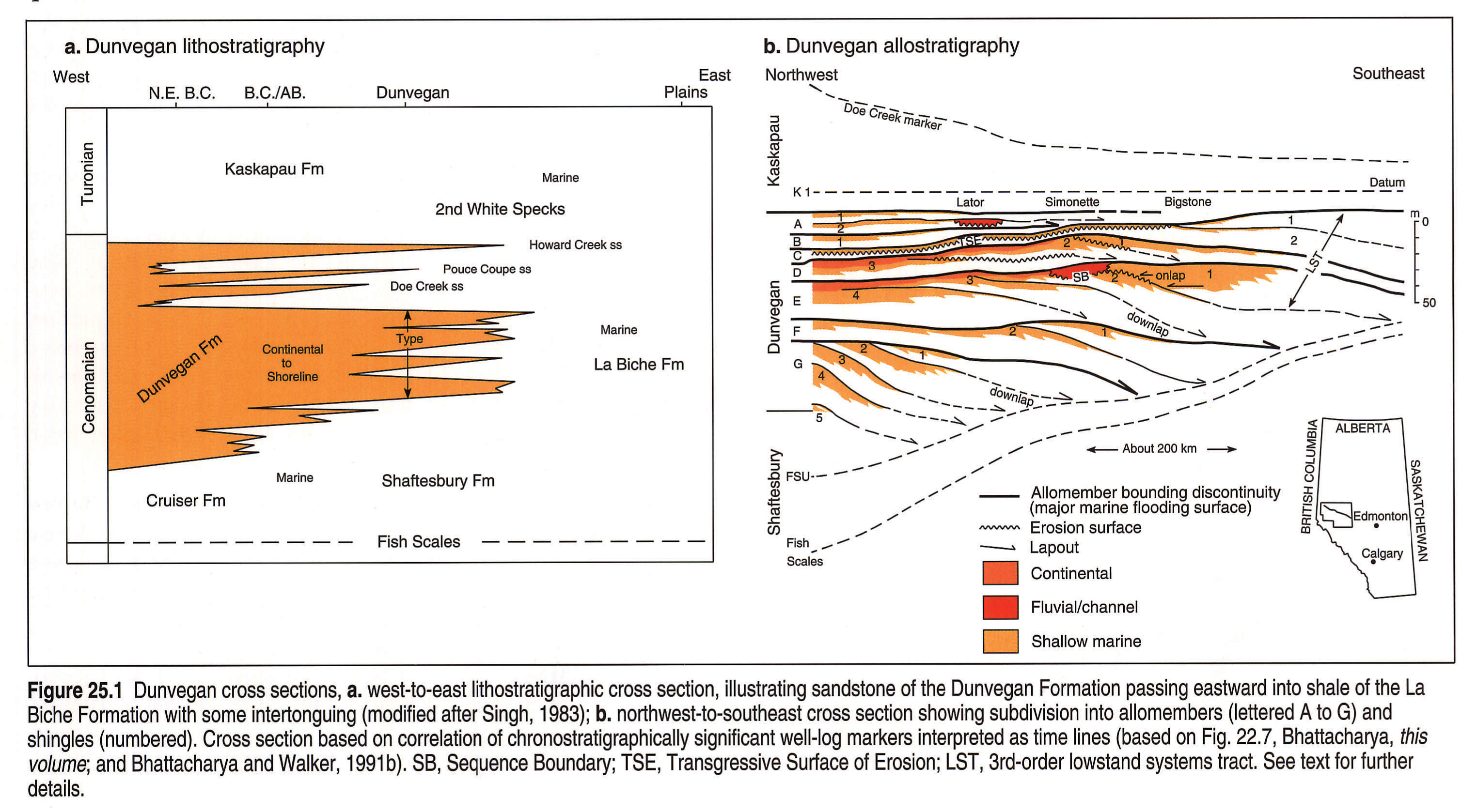
Figure 25.1 contrasts the two approaches as applied to the Upper Cretaceous Dunvegan Formation in northwestern Alberta. In the lithostratigraphic interpretation (Fig. 25.1a), the Dunvegan Formation is shown as a sandy clastic wedge that interfingers with shales of the Shaftesbury Formation below and the Kaskapau Formation above. Farther east, the Dunvegan pinches out into shales of the La Biche Formation (Singh, 1983). Several marine tongues are shown within the Dunvegan Formation.
An allostratigraphic interpretation of the same rocks elucidates the nature of this interfingering (Fig. 25.1b) and incorporates the time-marker approach. The cross section (Fig. 25.1b) shows that the Dunvegan Formation has been subdivided into seven allomembers (lettered A to G), representing regressive sedimentary events, each capped by a marine flooding surface associated with transgression (Bhattacharya, 1988; Bhattacharya and Walker, 1991a; Bhattacharya, this volume, Chapter 22). These seven flooding surfaces are interpreted as representing chronostratigraphically significant bounding discontinuities that can be correlated over hundreds of kilometres. More importantly, the surfaces can be correlated as time-markers into the Kaskapau and Shaftesbury shales. The allomembers thus represent lithologically heterogenous units that contain strata previously included in different formations. The allomember boundaries cut across the conventional lithostratigraphic boundaries but better illustrate the genetic relations between the different lithostratigraphic units.
Historical Perspective
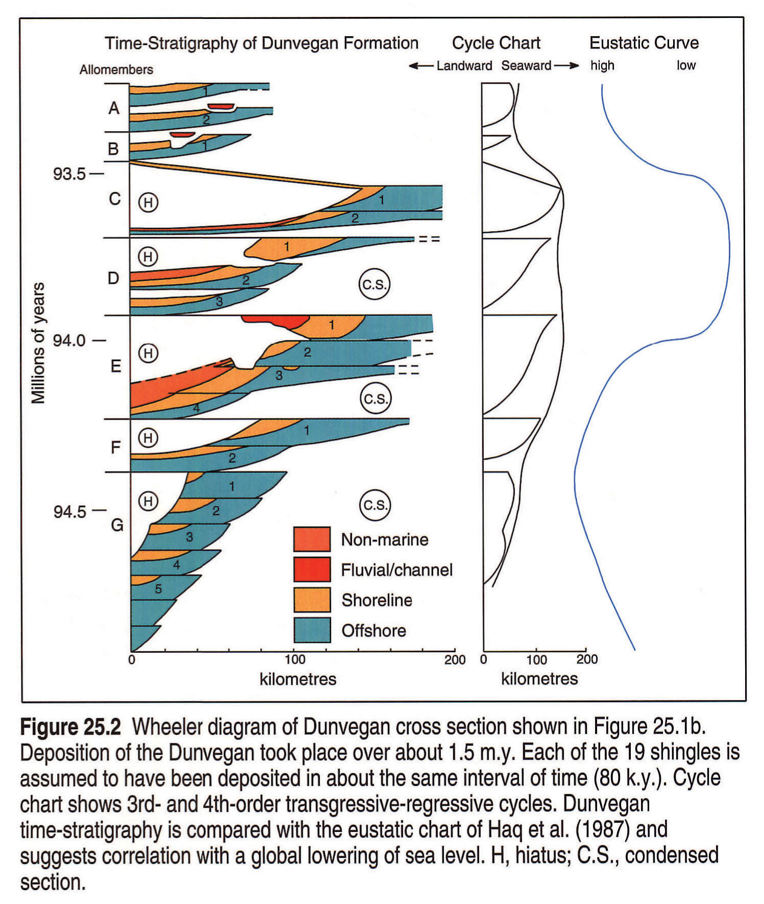
Ideas regarding changes in base level as a control on sedimentation can be traced back to the work of Grabau (1906), Blackwelder (1909), and Barrell (1912, 1917). Their ideas were formalized into the concept of time-stratigraphy by Wheeler (1958), who recognized that the duration of hiatuses in sedimentary successions is as important as the rocks actually present. Wheeler (1958) depicted geological cross sections in terms of time represented. An example of a time-stratigraphic diagram for the Dunvegan example shown above is illustrated in Figure 25.2. Sloss (1963) applied Wheeler's ideas to the North American craton and developed the concept of continent-wide unconformity-bounded units, which he termed sequences.
The availability of high-quality seismic data, acquired for petroleum exploration during the latter half of the 20th century, provided a data base that gave the geologist a continuous subsurface image of stratigraphic relations in areas not previously accessible. Scientists at Exxon Production Research Co. recognized the stratigraphic significance of the seismic tool. In their landmark publication, Vail et al. (1977) recognized that major unconformities could be identified by reflection terminations on seismic data and developed the concepts of seismic stratigraphy. They termed the depositional units bounded by these unconformities seismic depositional sequences (Mitchum et al., 1977). Vail et al. (1977) also observed that there was a striking similarity of coastal onlap geometry between widely separated ocean basins. They suggested that the cause of this apparent synchroneity of events was global sea-level change (eustasy). Their observations led to the publication of global sea-level charts (Vail et al., 1977; Haq et al., 1987, 1988).
The application of these new stratigraphic principles to outcrop, core, and well log data has led to the broader concept of sequence stratigraphy (Wilgus et al., 1988). With the publication of Jervey (1988), Loutit et al. (1988), Posamentier et al. (1988), Posamentier and Vail (1988), Sarg (1988), and Van Wagoner et al. (1990) the use of sequence stratigraphic concepts as a tool for lithology prediction came into its own. It also became apparent that sequence stratigraphic concepts were applicable at all spatial and temporal scales and could be applied using a variety of data bases including conventional seismic, outcrop, and flume studies (e.g., Baum and Vail, 1988; Greenlee and Moore, 1988; Posamentier et al., 1992a; Wood et al., in press). A strength of the sequence stratigraphic concepts has been to allow integration of diverse data bases including biostratigraphic data, geochemical data, and tectono-structural data (e.g., Leckie et al., 1990, 1992).
Sequence Stratigraphic and Allostratigraphic Principles
The recognition that lithostratigraphic units may be defined by chronostratigraphically significant surfaces has been incorporated into the North American Stratigraphic Code as allostratigraphy (NACSN, 1983). Allostratigraphy is a formally recognized way of defining and naming discontinuity-bounded rock successions without placing particular emphasis on which type of discontinuity should be used as the "fundamental" stratigraphic break. Allostratigraphic units, therefore, may include both unconformity- bounded depositional sequences, as defined by Mitchum (1977), and the genetic stratigraphic sequences proposed by Galloway (1989), which are based on marine flooding surfaces. Allostratigraphy represents a relatively generic way of defining and naming discontinuity-bounded rock successions and emphasizes mappability. Sequence stratigraphy represents a more powerful way of interpreting rock successions in the context of cyclical relative sea-level change (e.g., Posamentier and Vail, 1988; Posamentier et al., 1988). Sequence stratigraphy has two fundamentally different, yet powerful, applications:
- Age model predictions. This involves the analysis of sequences for the purpose of extracting a eustatic signal and then correlating with the global sea-level curve to determine the age of the rocks. The implicit assumption is the inherent validity of published global sea-level curves (e.g., Haq et al., 1987), although these have been criticized by Summerhayes (1986), Miall (1986), Hubbard (1988), and others.
- Lithology prediction. This involves the analysis of stratigraphic successions for the purpose of understanding temporal and spatial relations between rocks in the context of relative sea-level change. The use of sequence stratigraphy for lithology prediction is thus independant of a belief in eustasy as the underlying mechanism. The key to success is the correct identification and correlation of chronostratigraphically significant surfaces. This approach requires the integration of facies successions and time-stratigraphy. The interplay between sediment flux and relative sea-level change, rather than just eustasy, allows for recognition of the importance of local factors such as tectonics and sedimentation rate (Jervey, 1988; Posamentier et al., 1988; Posamentier and Vail, 1988).
Key Surfaces
Key surfaces having chronostratigraphic significance are used to define sequence stratigraphic and allostratigraphic units that make up the stratigraphic succession. The most important of these are erosional unconformities (Fig. 25.3). On seismic data (Mitchum et al., 1977; Vail et al., 1984) unconformities and other important boundaries are recognized on the basis of seismic reflection terminations. Seismic reflections are assumed to approximate physically continuous surfaces and are interpreted as time lines. The termination of one surface against another has been termed lapout (if depositional) and truncation where caused by erosion. Workers in modern environments (e.g., Demarest and Kraft, 1987; Nummedal and Swift, 1987), as well as in the ancient (e.g., Miall, 1984, p. 336-337; Embry and Podruski, 1988; Dixon and Dietrich, 1988; Bhattacharya and Walker, 1991a; and Walker, 1990) have realized that in detail, and especially at the outcrop or core scale of observation, seismic stratigraphic "discontinuity surfaces" may in fact represent a summation of a number of surfaces due to poor resolution of the seismic tool.
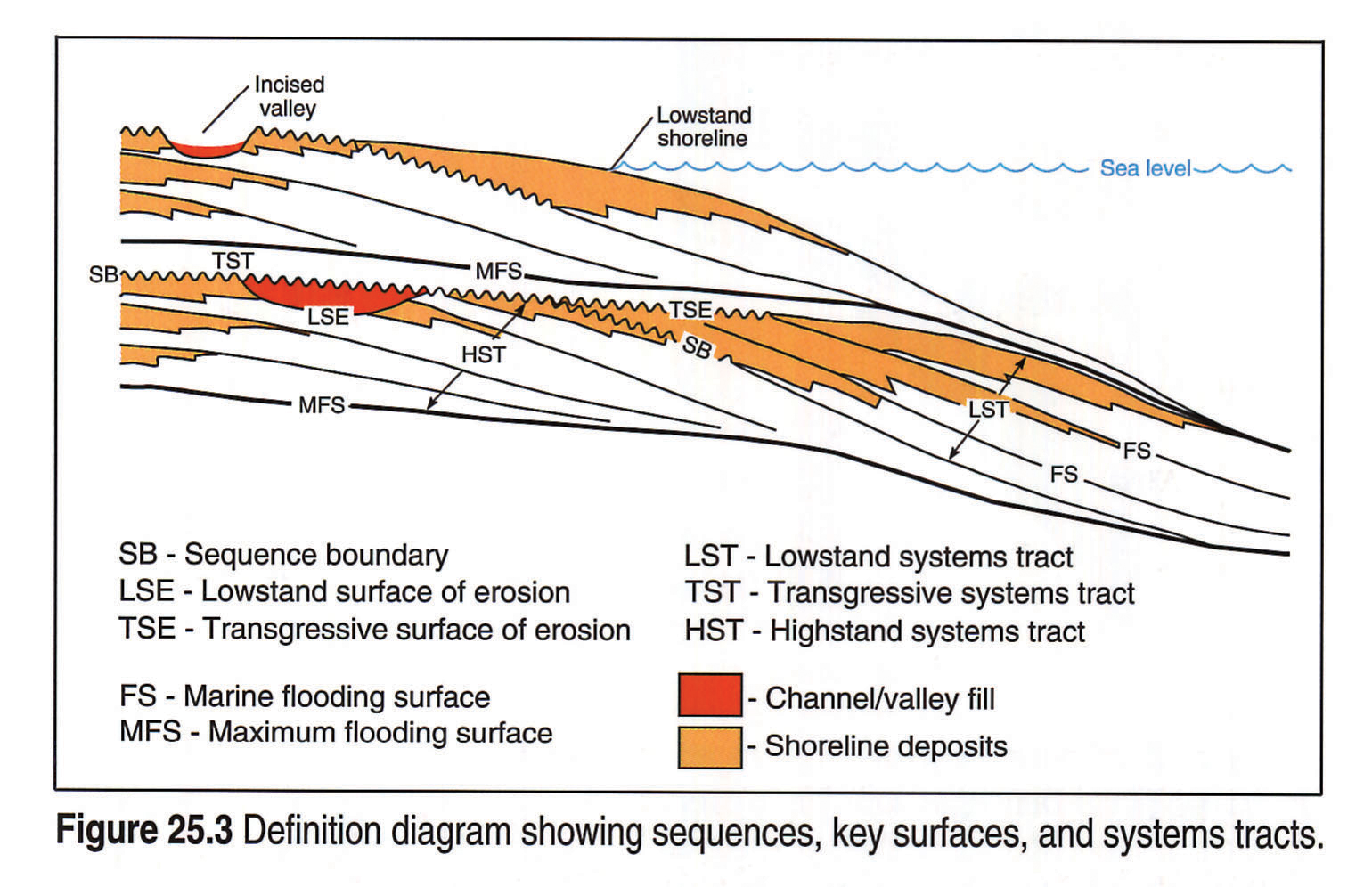
A type 1 sequence boundary (Mitchum et al.1977; Posamentier et al., 1988) is the unconformity surface that forms as relative sea-level fall is initiated (Fig. 25.4). It is accompanied by an abrupt seaward shift in shoreline facies and a basinward shift in onlap. Commonly, the unconformity is associated with areas of widespread subaerial exposure due to the drop in relative sea level, and may be associated with the formation of incised valleys and the subsequent development of soils on interfluve areas. The preservation potential of these features depends on the depth of fluvial incision as well as the amount of erosional truncation that occurs in association with subsequent marine transgression (ravinement), which may enhance erosion on the unconformity. In the marine realm the sequence boundary may be expressed as an erosional surface at the base of an incised shoreface (Plint, 1988). Farther seaward, marine erosion may occur in response to impingement by waves on the previously quiescent sea floor (Curray, 1964; Plint, 1991). Eventually, the sequence boundary passes into a correlative conformity. Weimer (1988) has used the term lowstand surface of erosion, or LSE, to describe the sequence boundary. Bhattacharya and Walker (1991a) used the term regressive surface of erosion (RSE).
Other surfaces that are commonly observed, and have varying degrees of chronostratigraphic significance, include the ravinement surface or transgressive surface of erosion (TSE), flooding surfaces, and maximum flooding surfaces, the latter associated with the time of peak transgression, (Fig. 25.3 , 25.4). In places, some of these surfaces may merge with the sequence-bounding unconformity. Plint (1988) showed that evidence for an erosional surface produced by falling sea level was completely removed by ravinement within the Upper Cretaceous Cardium Formation of Alberta. A similar interpretation was made for the Lower Cretaceous Viking Formation of Alberta (Posamentier and Chamberlain, in press). Consequently, in these cases, the TSE and LSE are inferred to have merged and the sequence-bounding unconformity is a composite surface.
Transgression-related surfaces, with the exception of the maximum flooding surface, are all to some extent diachronous, although they commonly may be considered nearly instantaneous at a regional to subregional scale, and particularly at the seismic scale (Van Wagoner et al., 1990; Bhattacharya and Walker, 1991a). Nonetheless, in contrast to subaerial unconformities, which may be difficult to recognize, transgression-related surfaces may be easier to identify in core, outcrops, and well-log data, and consequently can serve as useful correlation markers and as bounding discontinuities for allostratigraphic units (e.g., Bhattacharya and Walker, 1991a) and for genetic stratigraphic sequences (Galloway, 1989).
Sequences, Systems Tracts, ParasequenceSets, and Parasequences
Sequences are defined as genetically related strata bounded by unconformities or their correlative conformities (Mitchum, 1977). Each sequence is composed of systems tracts, which are defined as linked co-eval depositional systems (Brown and Fisher, 1977; and modified by Posamentier et al., 1988). A sequence consists of three systems tracts (Fig. 25.3). A Type I sequence consists of a lowstand systems tract (LST), a transgressive systems tract (TST), and a highstand systems tract (HST), and a Type II sequence consists of a shelf-margin systems tract (SMST), a transgressive systems tract (TST), and a highstand systems tract (HST). Type I sequences develop in response to relative sea-level fall, whereas Type II sequences develop in response to slowdowns and then acceleration of relative sea-level rise (Posamentier et al., 1988). Type I sequences seem to be significantly more common within the fill of the Alberta Basin and consequently Type II sequences will not be considered here.
Parasequences comprise the building blocks of many of the sequence stratigraphic and allostratigraphic units discussed here. They are defined as genetically related strata bounded by flooding surfaces or their correlative surfaces (Van Wagoner et al., 1990) and commonly are characterized by a shoaling-upward succession. Parasequences, in turn, can be grouped into parasequence sets (Van Wagoner et al., 1990) whose stratal patterns can be described as downstepping or forestepping (i.e., progradational), aggradational, and backstepping (i.e., retrogradational).
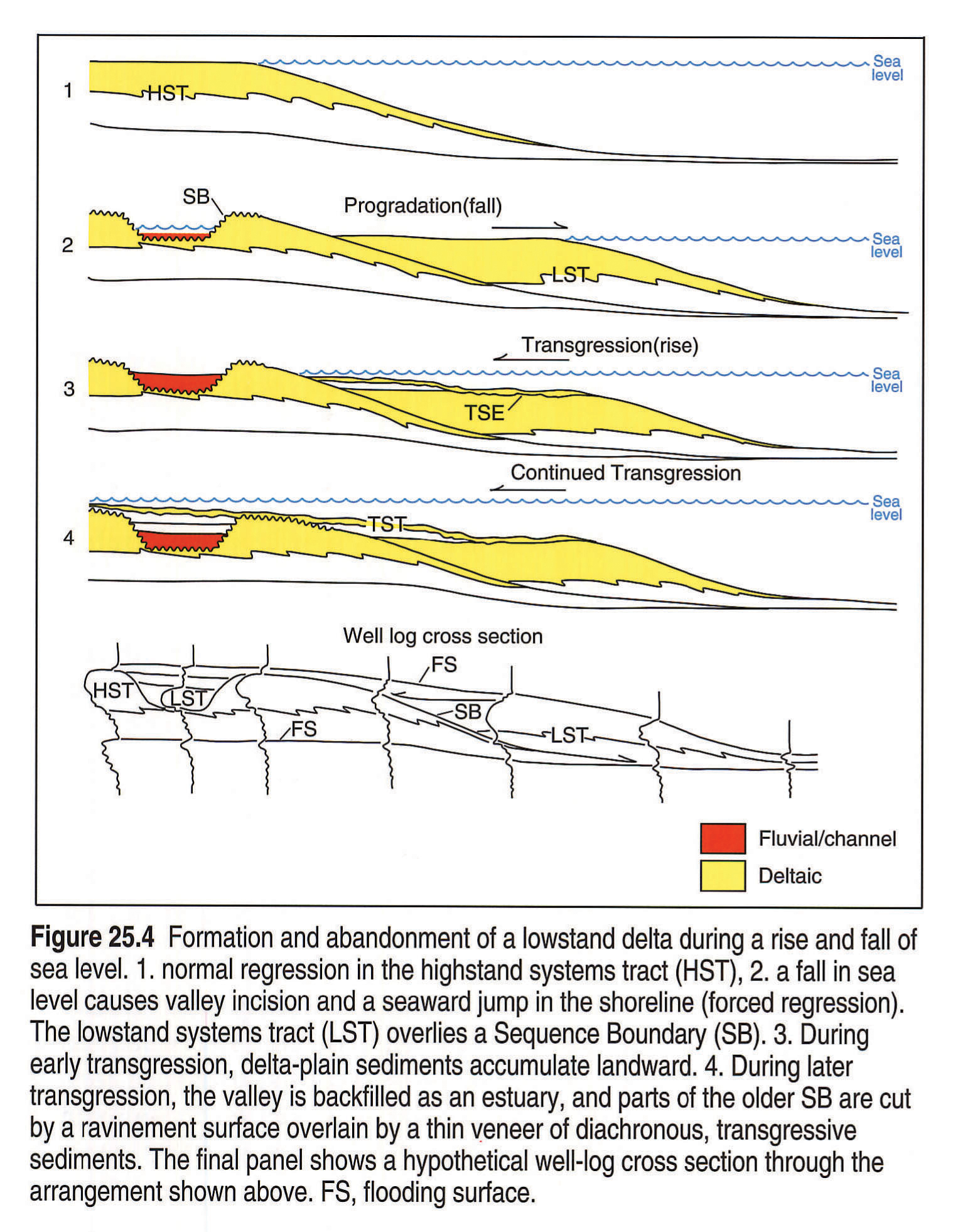
Systems tracts usually comprise a parasequence set characterized by a distinctive parasequence stacking pattern. Lowstand systems tracts (LST) are interpreted to have been deposited during relative sea-level falls and subsequent lowstands (Posamentier and Vail, 1988). LST's are characteristically deposited below the level of the coastal plain or shelf and commonly may have a basinally isolated (i.e., distal) distribution. The LST may include lowstand shoreline, lowstand delta, and deep-water submarine fan, although the latter are rare within the Alberta Basin. Farther landward the LST may be characterized by incised valleys. The stratal geometry that commonly characterizes the early and middle LST comprises a downstepping and/or forestepping pattern (Fig. 25.4) as the shoreface jumps seaward (i.e., forced regression of Posamentier et al., 1990, in press). The late LST may be characterized by an aggradational stacking pattern occurring in response to slow relative sea-level rise in which the shoreline position does not change. Thus, shorelines are observed to be regressive to stillstanding throughout the LST.
Transgressive systems tracts (TST) are interpreted to have been deposited during intervals of rapid relative sea-level rise (Posamentier and Vail, 1988). At this time sediment supply is exceeded by the rate of new space added on the shelf (i.e., new accommodation) and overall shoreline transgression occurs. Several parasequences may comprise the TST. Whereas each parasequence may be regressive in its own right, successive parasequences lie in a progressively more landward position resulting in a backstepping stacking pattern. This systems tract may include estuarine, shoreface, coastal plain, and deltaic depositional systems.
Highstand systems tracts (HST) are inferred to have been deposited during intervals of decelerating relative sea-level rise (Posamentier and Vail, 1988). At this time, the sedimentation rate exceeds the rate at which new space is added on the shelf, resulting in shoreline regression. The stratal geometry that commonly characterizes the HST is forestepping (i.e., progradation) in which shoreline sediments within successive parasequences lie in a progressively more seaward position (Fig. 25.3). Fluvial, shoreline, and deltaic depositional systems are most common in the HST. Shelf-edge deltas and submarine fans are uncommon in the HST and are more characteristic of the LST.
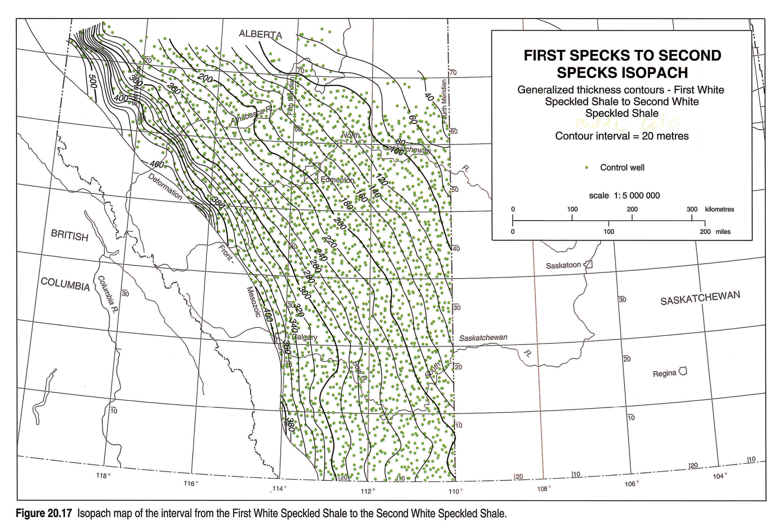
Condensed sections are coeval facies equivalents seaward of all systems tracts, and develop beyond the influence of most terrigenous sedimentation (Fig. 25.2; Loutit et al., 1988). Condensed sections are deposits wherein significant amounts of time are represented by anomalously thin units. Commonly, condensed sections are characterized by a "hot" gamma-ray log response and by faunal peaks. Examples of condensed sections in the Western Canada Sedimentary Basin include the Fish Scales and 1st and 2nd White Specks (Leckie et al., this volume, Chapter 20). The speckled nature of these shales results from an enrichment in calcareous microfossils.
Time Concepts
The assumption that seismic reflections represent time lines is also inherent in the interpretation of well-log correlations discussed here. It is assumed that the correlation lines correspond to physically continuous surfaces and hence time-markers. Where available, time markers such as bentonites or biostratigraphic picks should be used in conjunction with discontinuity surfaces in sequence stratigraphic correlations.
The absolute duration of unconformities and other chronostratigraphically significant surfaces can be estimated using a combination of biostratigraphic, geochemical, and radiometric dating methods. Isotopic age determinations from the Cretaceous usually have an uncertainty of about 1 million years (e.g., Obradovich and Cobban, 1975). Ammonite and foraminiferal biozones in the Cretaceous Western Interior Seaway allow further relative subdivision, which may be tied to absolute geolgical time scales. Many of the units discussed below, however, are below the limits of biostratigraphic resolution, and it may be possible to show only the relative timing of events.
Time-stratigraphic diagrams (Wheeler, 1958) are a useful way of depicting time-stratigraphy. They depict rock sections in time and space, in contrast to lithostratigraphic sections, which depict only spatial relations. Consequently, "Wheeler diagrams" facilitate an understanding of the meaning, duration, and lateral extent of unconformities and discontinuities. The Dunvegan example (Fig. 25.2) illustrates how Wheeler diagrams are used to show the relative duration of hiatuses, the intervals associated with condensed sections, and periods of sedimentary infilling.
Sequence Stratigraphy of the Passive Margin Versus the Foreland Basin Successions
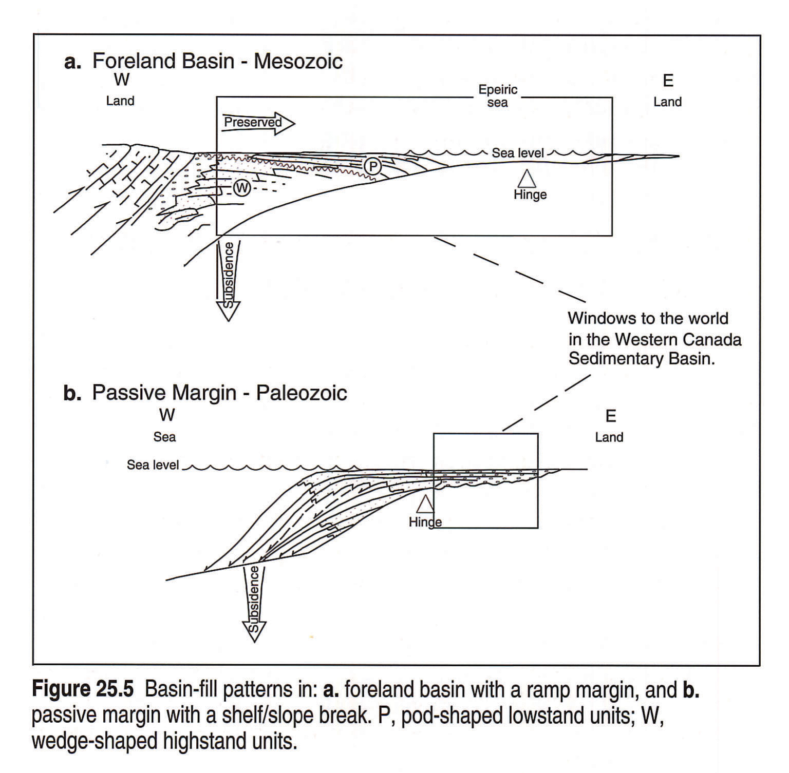
Models for sequences and systems tracts were developed originally for continental margins characterized physiographically by a discrete shelf/slope break (see Posamentier et al., 1988, Figs. 1-6). Typically, this physiography occurs on trailing-edge passive, as well as active, continental margins. Key observations used to interpret sedimentary sequences in the context of seismic stratigraphy are changes in coastal onlap patterns (Fig. 25.5b). On passive continental margins, these patterns commonly can be observed because the basin margin against which sediments onlap (i.e., the landward margin) is typically preserved and available for study. In addition, the landward margin is relatively quiescent tectonically with subsidence increasing in a seaward direction. Because tectonic activity usually plays a secondary role relative to eustasy in these types of basin margins, major unconformities can be related more directly to eustatic changes.
During the Precambrian, Paleozoic and into the Early Jurassic, the Western Canada Sedimentary Basin could be characterized as a depocenter situated on a passive or trailing-edge continental margin (Kent, this volume, Chapter 7). The part of the basin presently available for study in the subsurface comprises interior epeiric shelf deposits of the cratonic platform (Fig. 25.5b). Most of the presumed deeper water sedimentary rocks deposited farther seaward are presently eroded away or lie exposed in the Rocky Mountains. Examples of sequence development in the passive margin succession are documented in Henderson (1989) and Gibson and Barclay (1989).
With the onset of thrust faulting from the west during the Jurassic, a foreland basin began to form along the ancestral Rockies (Price, this volume, Chapter 2). The stratal arrangements of the subsequent basin fill are distinctly different from those that developed on the preceding passive margin (Fig. 25.5a). The foreland basin was characterized by a ramp margin. A ramp margin is characterized by a relatively low-gradient shelf without an apparent shelf/slope break.
The foreland basin is characterized by subsidence due to flexural loading by thrust sheets, wherein subsidence decreases in a seaward direction away from the fold and thrust belt, in marked contrast to passive margin settings, where subsidence increases in a seaward direction (Fig. 25.5a, b). In much of the Lower Cretaceous section, because the foreland basin trough lay west of our presently preserved "window to the world", we commonly do not see much effect of this eastward decrease of rate of subsidence, except in northeast British Columbia (Hayes et al., this volume, Chapter 19). Consequently, the effect of "backward rotation" of the section due to higher subsidence rates westward plays a minimal role on the stratal architecture of most of the rocks we can observe in the basin during this interval. In contrast, however, the "window to the world" in the Upper Cretaceous section includes a section closer to the foreland basin trough and is characterized by a wedge that thickens westward toward the fold and thrust belt (e.g., Leckie et al., this volume, Chapter 20; Dawson et al., this volume, Chapter 24) suggesting closer proximity to the contemporaneous thrust sheets. Consequently, the "backward rotation" of the section can play a significant role in this part of the section.
Another distinctive aspect of this foreland basin that is in marked contrast with the predecessor passive-margin basin is that two provenances exist: one from the fold and thrust belt to the west and one from the stable craton to the east. As the basin deepened during the middle and Late Cretaceous and the foreland trough migrated eastward, the westerly provenance came to dominate the fill. The proportion of easterly derived sediment decreases upsection and represents a trivial component for much of the Upper Cretaceous and Tertiary.
The stratal architecture on basin margins is strongly influenced by shelf gradients. In a ramp-type margin, such as characterized the Cretaceous Alberta Basin, the gentle gradient of the basin profile is broken only by the relatively steep shoreface. Lowstand deposits commonly are represented by basinally isolated shorelines rather than by the deep-water turbidite deposits more common in passive margin settings. Unconformities or sequence boundaries in ramp-type settings may be expressed as zones of sedimentary bypass (e.g., Posamentier et al., 1992b), by incised valleys (e.g., Van Wagoner et al., 1990), or by sharp-based shoreface successions (e.g., Plint, 1988). The process by which these isolated shoreline deposits are produced has been referred to as a forced regression (Posamentier et al., 1990; 1992b). An example of a lowstand shoreface formed in response to a forced regression is shown in Figure 25.4.
In the Western Canada Foreland Basin, highstand deposits that occur in the western proximal basin settings are commonly not readily accessible for study as they were the first deposits to be overridden by advancing thrust sheets. We assume that the landward margin of much of the Western Canada Foreland Basin succession was not preserved as a result of subsequent tectonic uplift and deformation (Fig. 25.5a). In addition, even when portions of the landward margin of the basin are preserved, the infilling sediments commonly comprise thick non-marine facies (e.g., Belly River Formation, Dawson et al., this volume, Chapter 24) in which recognition of sequence-bounding discontinuities, let alone onlap patterns, are difficult to determine. The part of the foreland basin most easily studied is thus the distal end, which commonly comprises marine lithofacies.
Foreland basins are likely to have a strong tectonic overprint on the nature of the stratigraphic successions preserved. Nonetheless, in the Western Canada Foreland Basin, with a sediment source from both the fold and thrust belt to the west as well as the craton to the east, a eustatic fall may have different effects in different areas. Eustatic fall may result in a relative sea-level fall yielding a Type I unconformity on the slowly subsiding eastern cratonic side of the seaway, whereas in the more actively subsiding western part, the same eustatic fall may result only in a decelerated relative sea level rise yielding a Type II unconformity. Because of the difficulty of recognizing a seaward shift in onlap, the type II unconformity may be easily missed. Consequently, the nature of the sequence-bounding surfaces as well as the internal stratal architecture of sequences is dependent on the position in the basin. During active tectonism, foreland basin subsidence may dominate, resulting in an overall relative rise of sea level. During times of tectonic quiescence, the foreland basin may experience uplift as a result of isostatic rebound resulting in a relative sea-level fall and redistribution of coarse sediments farther into the basin centre (Heller et al., 1988). A eustatic rise of sea level may also be enhanced in the foreland basin, particularly in the foreland trough, as a result of the superimposed tectonic subsidence. This may result in more extensive flooding and other transgressive surfaces (Swift et al., 1987).
Selected Examples of Sequence Stratigraphic and Allostratigraphic Applications in the Foreland Basin Succession
The sequence framework for North America as defined by Sloss (1963) was most recently applied to the Western Canada Sedimentary Basin in Ricketts (1989). That volume also includes many examples of depositional sequences (in the sense of Mitchum, 1977), most of which are included also in this atlas. Other examples of depositional sequence interpretation in the Western Canada Foreland Basin include Leckie (1988, Paddy and Cadotte members of the Peace River Formation), Posamentier and Chamberlain (in press, Viking Formation), Reinson et al. (this volume, Chapter 21, Viking Formation), Bhattacharya (this volume, Chapter 22, Dunvegan Formation), Plint et al. (1986, Cardium Formation), Plint et al. (1990, Bad Heart Formation), and Bhattacharya (1991, Chungo/Milk River). The following section summarizes sequence stratigraphic interpretations of selected stratigraphic units within the Western Canada Sedimentary Basin.
Jurassic
Poulton et al. (this volume, Chapter 18) discuss some of the significant unconformities associated with the earliest strata of the foreland basin succession in the Late Jurassic, incorporating much of the available biostratigraphic data. These strata also contain the only well documented deep-water turbidite facies in the foreland succession (Hamblin and Walker, 1979), although these have not yet been placed in an overall sequence framework.
Mannville
Mannville strata have been interpreted in terms of major transgressions and regressions (Cant, 1989; Hayes et al., this volume, Chapter 19). Detailed time-stratigraphic correlations are available for selected areas, although the complex nature of correlations in this unit has precluded a truly comprehensive sequence stratigraphic interpretation. During much of Mannville deposition, the foreland trough lay to the west, and the preserved eastern part of the basin is characterized by non-marine deposits, incised valley fills, and lowstand shoreline deposits shed from the stable craton to the southeast.
Colorado/Alberta Group
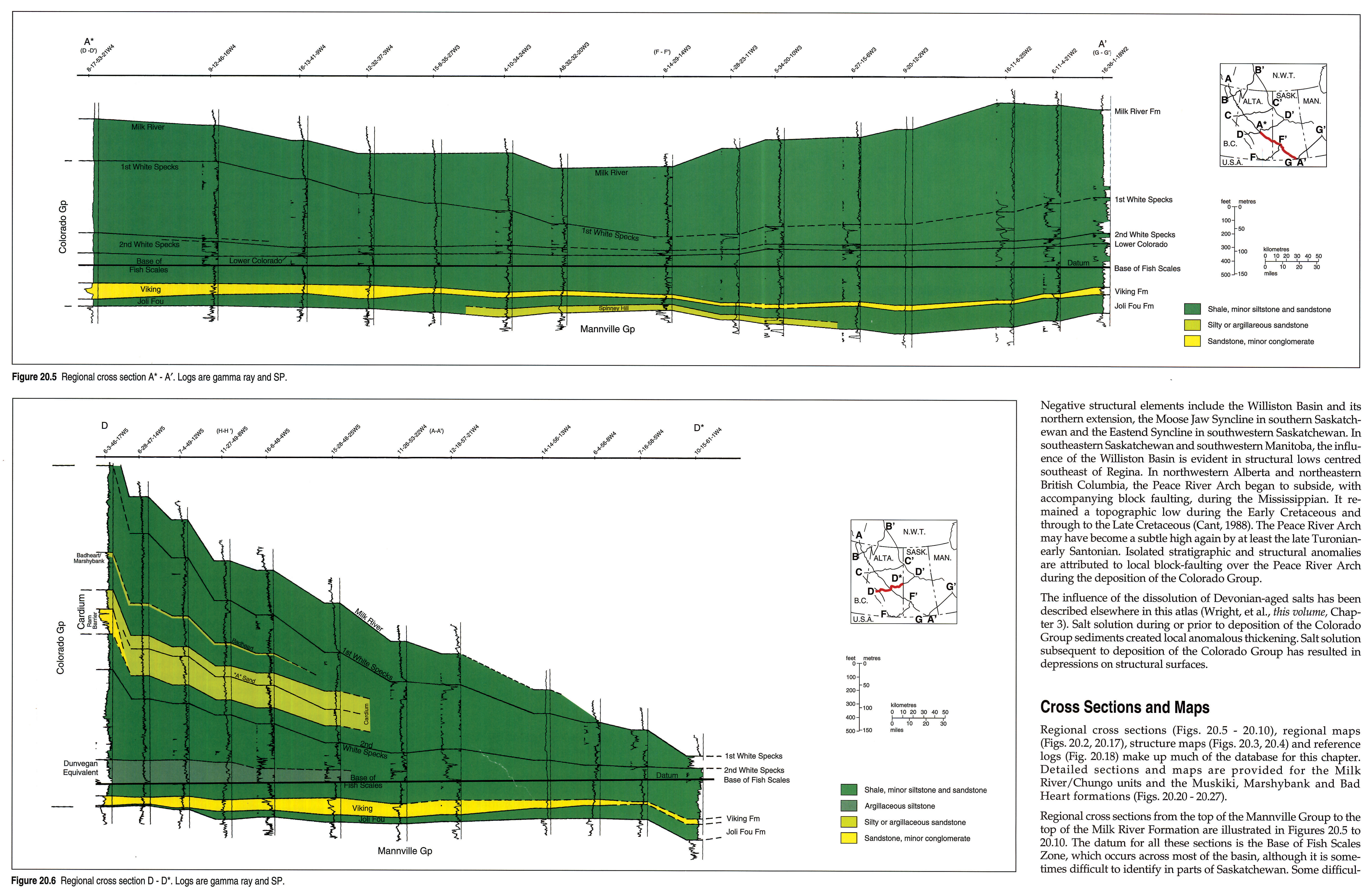
The Colorado/Alberta Group (Leckie et al., this volume, Chapter 20) is dominated by shales interbedded with thinner sandy units, including the Viking, Dunvegan, Cardium and Bad Heart formations. These sandstones have been recently interpreted as being associated with global sea-level falls, based on correlation with the Haq et al. (1987) curve (Bhattacharya, 1988; Pattison, 1991; Plint, 1991). Atlas cross sections through the foreland fill clearly show markers diverging westward as the wedge thickens (Leckie et al., this volume, Fig. 20.6). Flexurally induced tectonic subsidence, as indicated by the wedge-shaped nature of the foreland fill (Fig. 20.6), was clearly the determining factor in creating accommodation. The timing of unconformities and internal stratal architecture, however, seems to have been controlled in part by eustasy. When relative sea level was high, the basin depocenter shifted westward, resulting in the fill being dominated by marine shales. When relative sea level was lower, sandstones and conglomerates were deposited in nearshore to non-marine environments that occurred farther seaward toward the center of the basin (e.g., Cardium, Dunvegan, Viking).
As a general rule, many of the significant reservoirs in the foreland basin fill are associated with unconformities inferred to be related to relative sea-level falls. Examples include the Simonette channel-fill and Waskahigan estuary-fill deposits within the Dunvegan Formation (Bhattacharya, 1989, this volume) and the Crystal channel-fill deposits and Joarcam lowstand shoreface in the Viking Formation (Reinson et al., this volume, Chapter 21; Allen and Posamentier, 1991; Posamentier and Chamberlain, in press).
Reservoirs within units underlain by transgressive disconformities produced during relative sea-level rise also are significant. Examples of these types of reservoirs include the Carrot Creek Member of the Cardium Formation (Bergman and Walker, 1986), and strata within the transgressive systems tract at Joarcam Field in the Viking Formation (Posamentier and Chamberlain, in press). Productive sandstones of the Doe Creek Member of the Kaskapau Formation lie within a transgressive systems tract (Leckie et al., this volume, Chapter 20).
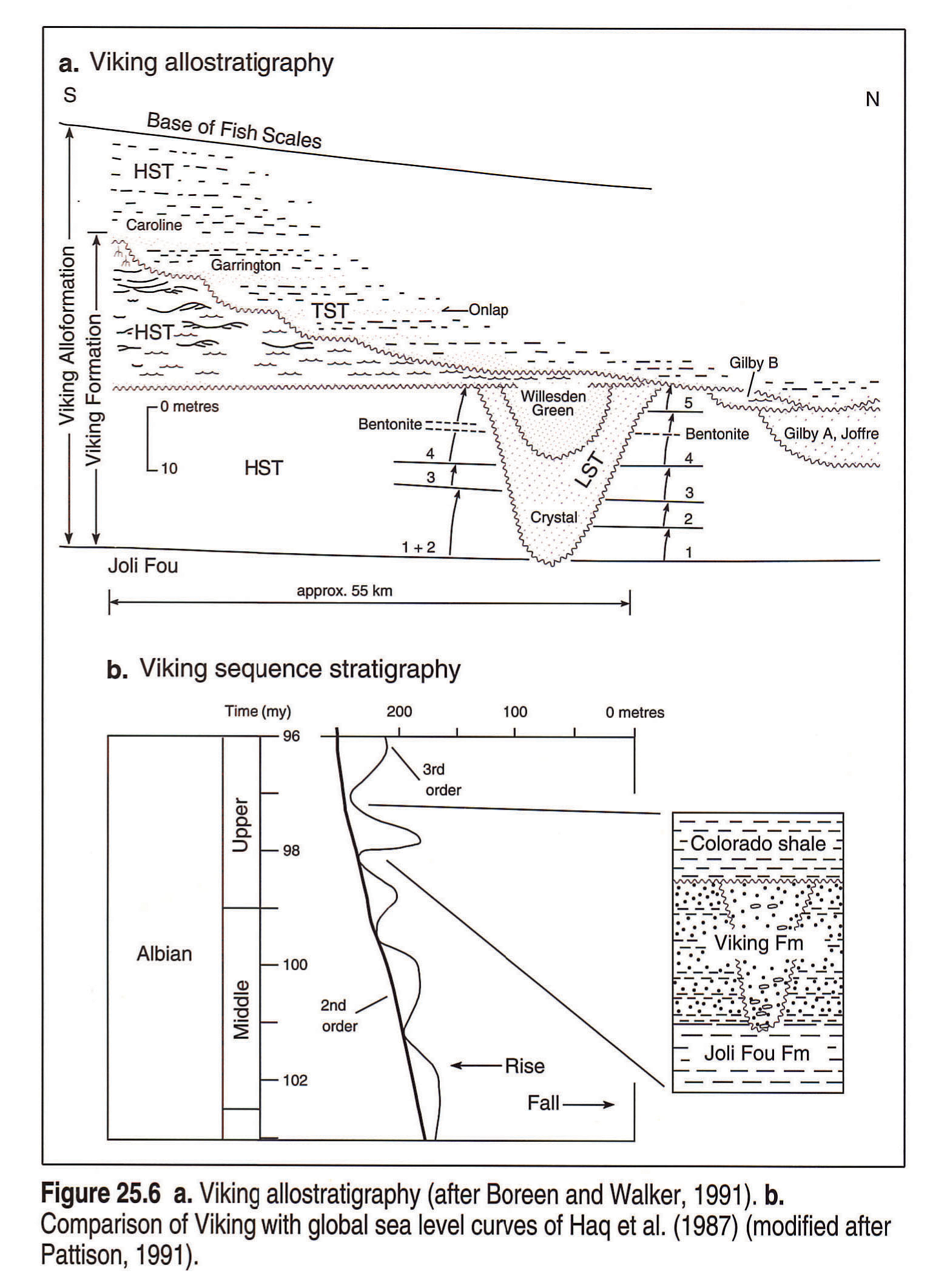
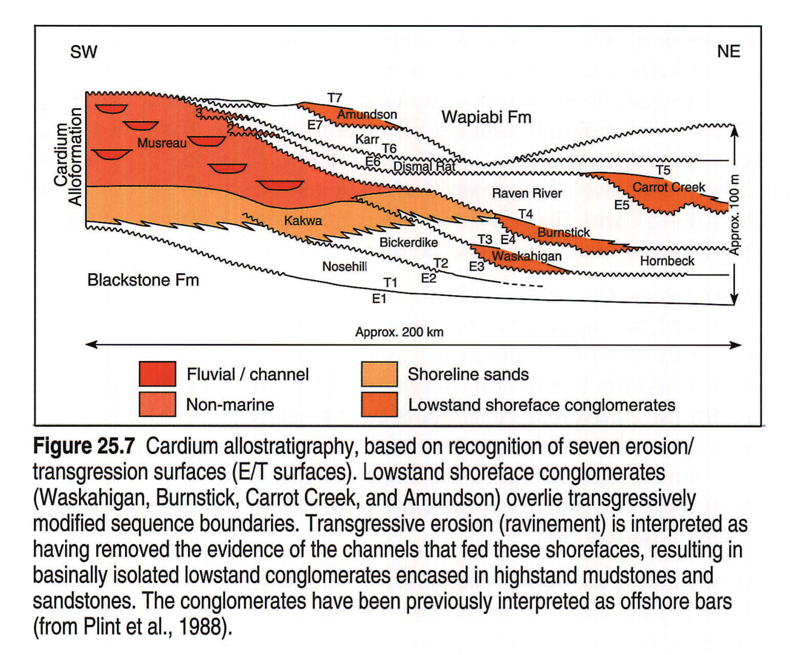
Allostratigraphic subdivisions have been proposed recently for the Viking (Fig. 25.6a; Boreen and Walker, 1991); Dunvegan (Fig. 25.1b; Bhattacharya and Walker, 1991a), Cardium (Fig. 25.7; Plint et al., 1986), and Marshybank and Muskiki formations (this volume, Fig. 20.17; Plint, 1990). The bounding discontinuities for these allostratigraphic units include both flooding surfaces and unconformities. In the Viking and Dunvegan, the new allostratigraphic units incorporate facies formerly included in the associated shaly formations but now interpreted as being genetically associated with the sandy formations. The occurrence of major unconformities within these sandy formations also suggests that previous lithostratigraphic correlations incorporate strata that belong to different sequences and that are not genetically related.
Viking. The allostratigraphic units within the Viking (as defined by Boreen and Walker, 1991) have provided a framework for interpretation within the context of relative sea-level change. Boreen and Walker (1991) have defined the top of the Viking alloformation at the Base of Fish Scales marker horizon (Fig. 25.6a). Consequently, they have included strata of the shaly lower Shaftsbury Formation within the Viking alloformation.
A sequence stratigraphic framework for the Viking is also proposed by Reinson et al. (this volume, Chapter 21) where highstand, lowstand and transgressive systems tracts have been identified. A significant sequence-bounding unconformity is indicated by a major valley incision (Crystal field) interpreted to relate to a eustatic fall at about 98 m.y. (Fig. 25.6b). Subsequent rise resulted in extensive ravinement within the TST.
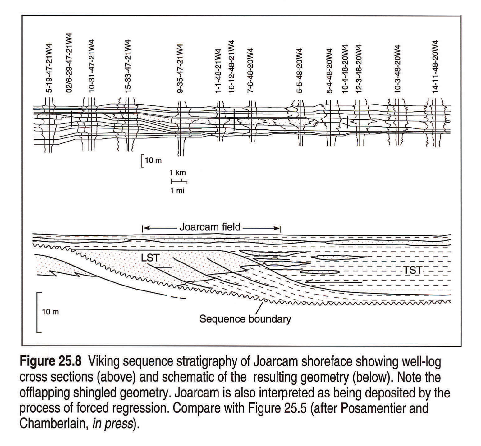
Posamentier and Chamberlain (in press) show an example of the application of high-resolution sequence stratigraphy at the scale of an oil field within the Viking Formation (Fig. 25.8). The recognition and exploitation significance of lowstand and transgressive systems tracts within the Joarcam field is explained. Figure 25.8 shows a forestepping to downstepping geometry between progradational lowstand shorefaces at Joarcam and contrasts with the more parallel strata in the overlying TST (Fig. 25.8). Posamentier and Chamberlain (in press) also show that the Joarcam shoreface is apparently not associated with a well-defined feeder system, thus resulting in a basinally isolated sandy deposit.
Dunvegan-related Strata. Parasequences within the Dunvegan downlap onto an underlying marker (referred to as the FSU marker by Bhattacharya, this volume, Chapter 22) (Fig. 25.1b). The shales between the Base of Fish Scales and the FSU are interpreted as representing the early HST. The Dunvegan contains a regional erosional surface (sequence boundary) that has been correlated with a third-order eustatic fall at 94 m.y. and that has been used to separate third-order highstand and lowstand systems tracts. A regionally traceable transgressive surface of erosion marks the contact between the lowstand and ensuing TST (Bhattacharya, this volume, Chapter 22). The transgressive systems tract (Fig. 20.13, which includes sandstones of the Doe Creek, Pouce Coupe and Howard Creek, culminates in the Second White Specks, which has been interpreted as another condensed section (Leckie et al., this volume, Chapter 20). The TST represents a good example of the characteristic backstepping pattern.
Cardium-related Strata. Highstand deposits comprising the Blackstone and lower portion of the Cardium Formation overlie the Second White Specks condensed section. Within the Cardium Formation, Plint et al. (1986) have recognized seven extensive erosional surfaces. Several of these surfaces are overlain by basinally isolated, thick, gravelly shoreface deposits, interpreted as representing lowstand or stillstand deposition punctuating an overall transgression. These erosional surfaces are thought to have formed initially as a result of a relative sea-level fall. In general, Cardium progradation correlates with a third-order eustatic fall of sea level at 90 m.y. (Cant, 1989), although exact correlation of the eustatic fall with one of the seven Cardium erosional surfaces is uncertain. Most of the Cardium unconformities have been interpreted as being the result of tectonic uplift of the western margin of the basin followed by subsidence (Bergman and Walker, 1988).
As a result of the ramp physiography of the basin during Cardium deposition, extensive feeder valley systems were not preserved because fluvial systems were not deeply incised. Consequently, fluvial deposits are interpreted to have been relatively thin and therefore readily eroded and redistributed by ravinement processes during subsequent transgression.
Bad Heart Related Strata. The Muskiki Formation represents a transgressive systems tract (TST) because it is characterized by a backstepping parasequence stacking pattern (Plint and Norris, 1991). This transgressive unit is overlain by a prominent condensed section beneath allostratigraphic unit A (Fig. 20.17). The Marshybank Formation, overlying the condensed section, is characterized by a progradational parasequence stacking pattern and thus has been interpreted as a highstand systems tract (Plint and Norris, 1991). Plint et al. (1990) have used a subregional unconformity to separate strata originally included in the Bad Heart Formation but now included in the underlying Marshybank Formation (see Leckie et al., this volume, Chapter 20). The rocks that overlie the unconformity (i.e., the newly defined Bad Heart) are referred to as LST deposits. Plint (1991) suggested that the unconformity relates to a third-order eustatic fall dated at 87 m.y. Plint (1991) also has suggested that some of the higher frequency parasequences may reflect Milankovitch-driven glacio-eustasy (4th-order sea-level falls).
Chungo/Milk River. Bhattacharya (1991) re-evaluated the Chungo Member of the Wapiabi Formation in sequence stratigraphic terms. The Chungo Member and Milk River Formation are interpreted as comprising an offlapping parasequence set, possibly representing a HST truncated by an extensive TSE (this volume, Fig. 20.21). Bhattacharya (1991) also showed that these parasequences thin and downlap to the north, forming the First White Specks condensed section. O'Connell et al.(1992) have shown that the TSE coincides with a sequence boundary that dips seaward to the north where it is overlain by basinally isolated lowstand shelf deposits of the Alderson Member.
Belly River
Dawson et al. (this volume, Chapter 24) show that the base of the Belly River Formation is diachronous over much of the basin and comprises a progradational parasequence set that downlaps to the east. Shales of the Lea Park Formation are shown to be genetically related to basal Belly River sandstones. Recent work by Eberth and Hamblin (1993) has demonstrated a tectonically produced unconformity within the overlying non-marine strata of the Belly River wedge.
Upper Cretaceous-Tertiary
To date there have been few sequence-oriented studies of the Upper Cretaceous and Tertiary strata in the Western Canada Sedimentary Basin. Recent work by Ainsworth and Walker (1991) recognized discontinuity-bounded units associated with the Bearpaw-Horseshoe Canyon transition in Drumheller, Alberta, and presented an interpretation in the context of relative sea-level change.
Conclusions
Fundamentally, sequence stratigraphy and allostratigraphy represent an approach to subdividing stratigraphic units on the basis of bounding discontinuities interpreted to have chronostratigraphic significance. Bounding discontinuities may be identified by anomalous facies relations, changes in stratal configuration, and biostratigraphic breaks. This contrasts with lithostratigraphy, in which stratigraphic units (e.g., formations) are distinguished primarily on the basis of lithology (i.e., facies).
Stratal geometry and associated sedimentary deposits that developed during the foreland basin phase of the Western Canada Sedimentary Basin (Late Jurassic to Tertiary) are distinctly different from those that characterize the passive margin succession (Precambrian, Paleozoic, and Triassic to Early Jurassic). The foreland basin was characterized by a gently sloping sea floor without a discrete shelf/slope break. Consequently, deep-water lowstand deposits, such as turbiditic submarine fans, are rare.
More typically, lowstand deposition is characterized by basinally isolated lowstand shoreface deposits commonly without preserved feeder-channel systems. Basinally isolated sandstones and conglomerates in both the Viking and Cardium have been interpreted previously as offshore bars, deposited tens to hundreds of kilometres from the nearest presently preserved shorelines and thought to be gradationally rooted in underlying shelf mudstones and sandstones. The newer sequence-based interpretations suggest that there is no genetic relation between the underlying shelf deposits and overlying sandstone and conglomerate because an unconformity separates the two lithofacies. Thus the previously interpreted "offshore bars" have been reinterpreted as lowstand shoreface sediments deposited in response to a relative sea-level fall. These interpretations embody the sequence stratigraphic approach, which recognizes the importance of unconformities and relative changes in sea level in controlling sand body geometry and facies distribution.
Incised valley deposits are observed within the foreland basin succession, though they are less common than on passive margins. With the exception of Lower Cretaceous Mannville strata (Hayes et al., this volume, Chapter 19), sandy highstand deposits that commonly occur in proximal basin settings are not readily accessible for study in this foreland basin because they would have been the first deposits to be overridden by the advancing thrust sheets (Fig. 25.5a). Consequently, preserved highstand deposits in the Alberta Basin are characterized by thick shales containing condensed sections, such as the Fish Scales and 1st and 2nd White Specks of the Colorado/Alberta Group.
The wedge-shaped geometry of much of the foreland basin fill reflects strongly asymmetrical subsidence that increases to the west. Although basin shape is dominated by tectonic subsidence, eustasy has some control on the stratal architecture of infilling sediments and the timing of the sequence-bounding unconformities. Several of the economically important sandy units, such as the Viking and Cardium formations, have been correlated with third-order eustatic falls and have been interpreted as lowstand deposits.
Acknowledgements
Work on this chapter began during tenure of a Natural Sciences and Engineering Research Council of Canada post-doctoral fellowship by J.P.B. Additional funding was provided by the Alberta Geological Survey and the Geological Survey of Canada. Our ideas have been sharpened by the many discussions that we have had with our friends and colleagues on the stratigraphy of the Alberta Basin. In particular we thank George Allen, Jim Barclay, Charles Henderson, David P. James, V. Kolla, Guy Plint, Terry Poulton, Roger Walker, and Jim Wood for sharing their ideas with us. We would also like to thank Dave Smith and Dave James for their thoughtful reviews and insights, which significantly improved the manuscript. Any shortfalls in interpretation, however, rest with the authors. We also thank ARCO Oil and Gas Company for permission to publish this paper.
References
- Ainsworth, R.B. and Walker, R.G. 1991. Sandbody geometry of disconformity-bounded, stacked, marginal marine units, Bearpaw-Horseshoe Canyon transition, Drumheller, Alberta. (abstract) Bulletin of Canadian Petroleum Geology. v. 39, p. 205.
- Allen, G.P. and Posamentier, H.W. 1991. Facies and stratal patterns in incised valley complexes: examples from the recent Gironde estuary (France), and the Cretaceous Viking Formation (Canada). (abstract) American Association of Petroleum Geologists, Bulletin, v. 75, p. 534.
- Barrell, J. 1912. Criteria for the recognition of ancient delta deposits. Geological Society of America, Bulletin, v. 23, p. 377-446.
- Barrell, J. 1917. Rhythms and the measurement of geological time. Geological Society of America, Bulletin, v. 44, p. 745-904.
- Baum, G.R. and Vail, P.R. 1988. Sequence stratigraphic concepts applied to Paleogene outcrops, Gulf and Atlantic region. In: Sea-level Changes: An Integrated Approach. C.K. Wilgus, B.S. Hastings, C.G. St. C. Kendall, H.W. Posamentier, C.A. Ross, and J.C. Van Wagoner (eds.). Society of Economic Paleontologists and Mineralogists, Special Publication 42, p. 309-327.
- Bergman, K.M. and Walker, R.G. 1986. Cardium Formation conglomerates at Carrot Creek Field: offshore linear ridges or shoreface deposits? In: Modern and Ancient Shelf Clastics, A Core Workshop, T.F. Moslow and E.G. Rhodes (eds.). Core Workshop of the Society of Economic Paleontologists and Mineralogists, Tulsa, p. 217-267.
- Bergman, K.M. and Walker, R.G. 1988. Formation of Cardium erosion surface E5, and associated deposition of conglomerate: Carrot Creek Field, Cretaceous Western Interior Seaway, Alberta. In: Sequences, Stratigraphy, Sedimentology; Surface and Subsurface. D.P. James and D.A. Leckie (eds.). Canadian Society of Petroleum Geologists, Memoir 15, p. 15-24.
- Bhattacharya, J. 1988. Autocyclic and allocyclic sequences in river- and wave-dominated deltaic sediments of the Upper Cretaceous Dunvegan Formation, Alberta: core examples. In: Sequences, Stratigraphy, Sedimentology; Surface and Subsurface. D.P. James and D.A. Leckie (eds.). Canadian Society of Petroleum Geologists, Memoir 15, p. 25-32.
- Bhattacharya, J. 1989. Esturine channel fills in the Upper Cretaceous Dunvegan Formation: core example. In: Modern and Ancient Examples of Clastic Tidal Deposits - A Core and Peel Workshop. G.E. Reinson (ed.). Canadian Society of Petroleum Geologists, Calgary, Alberta, p. 37-49.
- Bhattacharya, J. 1991. Parasequence architecture of the Upper Cretaceous Chungo Member and Milk River Formation in southern Alberta. (abstract) Bulletin of Canadian Petroleum Geology. v. 39, p. 206.
- Bhattacharya, J.P. (this volume). Cretaceous Dunvegan Formation of the Western Canada Sedimentary Basin. In: Geological Atlas of the Western Canada Sedimentary Basin. G.D. Mossop and I. Shetsen (comps.). Calgary, Canadian Society of Petroleum Geologists and Alberta Research Council, chpt. 22.
- Bhattacharya, J. and Walker, R.G. 1991a. Allostratigraphic subdivision of the Upper Cretaceous Dunvegan, Shaftesbury, and Kaskapau formations in the subsurface of northwestern Alberta. Bulletin of Canadian Petroleum Geology, v. 39., p. 145-164.
- Bhattacharya, J. and Walker, R.G. 1991b. River- and wave-dominated depositional systems of the Upper Cretaceous Dunvegan Formation, northwestern Alberta. Bulletin of Canadian Petroleum Geology, v. 39, p. 165-191.
- Blackwelder, E. 1909. The valuation of uncomformities. Journal of Geology, v. 17, p. 289-299.
- Boreen, T.D. and Walker, R.G. 1991. Definition of allomembers and their facies assemblages in the Viking Formation, Willesden Green area, Alberta. Bulletin of Canadian Petroleum Geology, v. 39, p. 123-144.
- Brown, L.F. and Fisher, W.L. 1977. Seismic-stratigraphic interpretation of depositional systems: examples from Brazil rift and pull-apart basins. In: Seismic Stratigraphy - Applications to Hydrocarbon Exploration. C.E. Payton (ed.). American Association of Petroleum Geologists, Memoir 26, p. 213-248.
- Cant, D.J. 1989. Lower Zuni Sequence: Middle Jurassic to Middle Cretaceous. In: Western Canada Sedimentary Basin; A Case History. B.D. Ricketts (ed.). Calgary, Canadian Society of Petroleum Geologists, p. 251-267.
- Curray, J.R., 1964. Transgressions and regressions. In: Papers in Marine Geology. R.L. Miller, (ed.). Macmillan, New York, p. 175-203.
- Dawson, F.M., Evans, C.G., Marsh, R., and Richardson, R. (this volume). Uppermost Cretaceous and Tertiary strata of the Western Canada Sedimentary Basin. In: Geological Atlas of the Western Canada Sedimentary Basin. G.D. Mossop and I. Shetsen (comps.). Calgary, Canadian Society of Petroleum Geologists and Alberta Research Council, chpt. 24.
- Demarest, J.M. and Kraft, J.C. 1987. Stratigraphic record of Quaternary sea levels: implications for more ancient strata. In: Sea-level Fluctuations and Coastal Evolution. D. Nummedal, O.H. Pilkey and J.D. Howard (eds.). Society of Economic Paleontologists and Mineralogists, Special Publication 41, p. 223-239.
- Dixon, J. and Dietrich, J.R. 1988. The nature of depositional and seismic sequence boundaries in Cretaceous-Tertiary strata of the Beaufort-Mackenzie Basin. In: Sequences, Stratigraphy, Sedimentology; Surface and Subsurface. D.P. James and D.A. Leckie (eds.). Canadian Society of Petroleum Geologists, Memoir 15, p. 63-72.
- Eberth, D.A. and Hamblin, A.P. (1993) Tectonic, stratigraphic, and sedimentologic significance of a regional disconformity in the upper Judith River Formation (Belly River Wedge) of Southern Alberta, Saskatchewan and Northern Montana. Canadian Journal of Earth Sciences, v. 30.
- Embry, A.F. and Podruski, J.A. 1988. Third-order depositional sequences of the Mesozoic succession of Sverdrup basin. In: Sequences, Stratigraphy, Sedimentology; Surface and Subsurface. D.P. James and D.A. Leckie (eds.). Canadian Society of Petroleum Geologists, Memoir 15, p. 73-84.
- Galloway, W.E. 1989. Genetic stratigraphic sequences in basin analysis I: architecture and genesis of flooding-surface bounded depositional units. American Association of Petroleum Geologists, Bulletin, v. 73, p. 125-142.
- Gibson, D.W. and Barclay, J.E. 1989. Middle Absaroka Sequence: the Triassic stable craton. In: Western Canada Sedimentary Basin; A Case History. B.D. Ricketts (ed.). Calgary, Canadian Society of Petroleum Geologists, p. 219-231.
- Greenlee, S.M. and Moore, T.C. 1988. Recognition and interpretation of depositional sequences and calculation of sea level changes from stratigraphic data - offshore New Jersey and Alabama Tertiary. In: Sea-level Changes: An Integrated Approach. C.K. Wilgus, B.S. Hastings, C.G.St.C. Kendall, H.W. Posamentier, C.A. Ross, and J.C. Van Wagoner (eds.). Society of Economic Paleontologists and Mineralogists, Special Publication 42, p. 329-353.
- Grabau, A.W. 1906. Types of sedimentary overlap. Geological Society of America, Bulletin, v. 17, p. 567-636.
- Hamblin, A.P. and Walker, R.G. 1979. Storm-dominated shallow marine deposits in the Fernie-Kootenay (Jurassic) transition, southern Rocky Mountains. Canadian Journal of Earth Sciences, v. 16, p. 1156-1167.
- Hayes, B.J.R., Christopher, J.E., Rosenthal, L., Los, G., McKercher, B., Minken, D.F., Tremblay, Y.M., and Fennell, J.W. (this volume). Cretaceous Mannville Group of the Western Canada Sedimentary Basin. In: Geological Atlas of the Western Canada Sedimentary Basin. G.D. Mossop and I. Shetsen (comps.). Calgary, Canadian Society of Petroleum Geologists and Alberta Research Council, chpt. 19.
- Haq, B.U., Hardenbol, J., and Vail, P.R.. 1987. Chronology of fluctuating sea levels since the Triassic. Science, v. 235, p. 1156-1166.
- Haq, B.U., Hardenbol, J. and Vail, P.R. 1988. Mesozoic and Cenozoic chronostratigraphy and cycles of sea level change. In: Sea-level Changes: An Integrated Approach. C.K. Wilgus, B.S. Hastings, C.G.St.C. Kendall, H.W. Posamentier, C.A. Ross, and J.C. Van Wagoner (eds.). Society of Economic Paleontologists and Mineralogists, Special Publication 42, p. 71-108.
- Heller, P.L., Angevine, C.L., and Paola, C. 1988. Two-phase model of foreland-basin sequences. Geology, v. 16, p. 501-504.
- Henderson, C.M. 1989. The Lower Absaroka Sequence: Upper Carboniferous and Permian. In: Western Canada Sedimentary Basin; A Case History. B.D. Ricketts (ed.). Calgary, Canadian Society of Petroleum Geologists, p. 203-217.
- Hubbard, R.J. 1988. Age and significance of sequence boundaries on Jurassic and early Cretaceous rifted continental margins. American Association of Petroleum Geologists, Bulletin, v. 72, p. 49-72.
- Jervey, M.T. 1988. Quantitive geological modeling of siliciclastic rock sequences and their seismic expression. In: Sea-level Changes: An Integrated Approach. C.K. Wilgus, B.S. Hastings, C.G.St.C. Kendall, H.W. Posamentier, C.A. Ross, and J.C. Van Wagoner (eds.). Society of Economic Paleontologists and Mineralogists, Special Publication 42, p. 47-69.
- Kent, D.M. (this volume). Paleogeographic evolution of the cratonic platform - Cambrian to Triassic. In: Geological Atlas of the Western Canada Sedimentary Basin. G.D. Mossop and I. Shetsen (comps.). Calgary, Canadian Society of Petroleum Geologists and Alberta Research Council, chpt. 7.
- Leckie, D.A. 1988. Sedimentology and sequences of the Paddy and Cadotte members along the Peace River. Canadian Society of Petroleum Geologists Field Trip Guide, Calgary, Alberta, 78 p.
- Leckie, D.A., Bhattacharya, J.P., Bloch, J., Gilboy, C.F., and Norris, B. (this volume). Cretaceous Colorado/Alberta Group of the Western Canada Sedimentary Basin. In: Geological Atlas of the Western Canada Sedimentary Basin. G.D. Mossop and I. Shetsen (comps.). Calgary, Canadian Society of Petroleum Geologists and Alberta Research Council, chpt. 20.
- Leckie, D.A., Singh, C., Bloch, J., Wilson, M., and Wall, J.H. (1992) An anoxic event at the Albian-Cenomanian boundary: the Fish Scale marker bed, northern Alberta, Canada. Paleogeography, Paleoclimatology, Paleoecology, v. 92, p. 139-166.
- Leckie, D.A., Singh, C., Goodarzi, F., and Wall, J.H. 1990. Organic-rich, radioactive marine shale: A case study of a shallow- water condensed section, Cretaceous Shaftesbury Formation, Alberta, Canada. Journal of Sedimentary Petrology, v. 60, p. 101-117.
- Loutit, T.S., Hardenbol, J., Vail, P.R. and Baum, G.R. 1988. Condensed sections: the key to age-dating and correlation of continental margin sequences. In: Sea-level Changes: An Integrated Approach. C.K. Wilgus, B.S. Hastings, C.G.St.C. Kendall, H.W. Posamentier, C.A. Ross, and J.C. Van Wagoner (eds.). Society of Economic Paleontologists and Mineralogists, Special Publication 42, p. 183-213.
- Miall, A.D. 1984. Principles of sedimentary basin analysis, New York, Springer-Verlag, 490 p.
- Miall, A.D. 1986. Eustatic sea level changes interpreted from seismic stratigraphy: a critique of the methodology with particular reference to the North Sea Jurassic record. American Association of Petroleum Geologists, Bulletin, v. 70, p. 131-137.
- Mitchum, R.M. Jr. 1977. Seismic stratigraphy and global changes of sea level, Part 1: Glossary of terms used in seismic stratigraphy. In: Seismic Stratigraphy - Applications to Hydrocarbon Exploration. C.E. Payton (ed.). American Association of Petroleum Geologists, Memoir 26, p. 205-212.
- Mitchum, R.M., Jr., Vail, P.R., and Thompson, S, III. 1977. Seismic stratigraphy and global changes of sea level, Part 2: The depositional sequence as a basic unit for stratigraphic analysis. In: Seismic Stratigraphy - Applications to Hydrocarbon Exploration. C.E. Payton (ed.). American Association of Petroleum Geologists, Memoir 26, p. 53-62.
- North American Commission on Stratigraphic Nomenclature. 1983. North American stratigraphic code. American Association of Petroleum Geologists, Bulletin, v. 67, p. 841-875.
- Nummedal, D. and Swift, D.J.P. 1987. Transgressive stratigraphy at sequence-bounding unconformities: some principles derived from Holocene and Cretaceous examples. In: Sea-level Fluctuations and Coastal Evolution. D. Nummedal, O.H. Pilkey and J.D. Howard (eds.). Society of Economic Paleontologists and Mineralogists, Special Publication 41, p. 241-260.
- Obradovich J.D. and Cobban, W.A. 1975. A time scale for the Late Cretaceous of the Western Interior of North America: In: The Cretaceous System of the Western Interior of North America. W.G.E. Caldwell (ed.). Geological Association of Canada, Special Paper 13, p. 31-54.
- O'Connell, S.C., Bhattacharya, J.P., and Braman, D.R. 1992. Sequence stratigraphy of the Upper Cretaceous Milk River and Lea Park formations, Alberta. (abstract) American Association of Petroleum Geologists, 1992 Annual Convention.
- Pattison, S.A.J. 1991. Sedimentology and allostratigraphy of regional, valley fill, shoreface and transgressive deposits of the Viking Formation (Lower Cretaceous) Central Alberta. Unpublished Ph.D. thesis, McMaster University, Hamilton, Ontario, 380 p.
- Plint, A.G. 1988. Sharp-based shoreface sequences and "offshore bars" in the Cardium Formation of Alberta: their relationship to relative changes in sea level. In: Sea-level Changes: An Integrated Approach. C.K. Wilgus, B.S. Hastings, C.G.St.C. Kendall, H.W. Posamentier, C.A. Ross, and J.C. Van Wagoner (eds.). Society of Economic Paleontologists and Mineralogists, Special Publication 42, p. 357-370.
- Plint, A.G. 1990. An allostratigraphic correlation of the Muskiki and Marshybank formations (Coniacian-Santonian) in the foothills and subsurface of the Alberta Basin. Bulletin of Canadian Petroleum Geology. v. 38, p. 288-306.
- Plint, A.G. 1991. High-frequency relative sea-level oscillations in Upper Cretaceous shelf clastics of the Alberta foreland basin: possible evidence for a glacio-eustatic control? In: Sedimentation, Tectonics and Eustasy; Sea-level Changes at Active Margins. D.I.M. Macdonald (ed.). International Association of Sedimentologists, Special Publication, v. 12, p. 409-428.
- Plint, A.G., and Norris, B. 1991. Anatomy of a ramp-margin sequence: facies successions, paleogeography and sediment dispersal patterns in the Muskiki and Marshybank formations, Alberta Foreland Basin. Bulletin of Canadian Petroleum Geology. v. 39, p. 18-42.
- Plint, A.G., Norris, B., and Donaldson, W. 1990. Revised definitions for the Upper Cretaceous Bad Heart Formation and associated units in the foothills and plains of Alberta and British Columbia. Bulletin of Canadian Petroleum Geology, v. 39, p. 78-88.
- Plint, A.G., Walker, R.G., and Bergman, K.M. 1986 Cardium Formation 6; Stratigraphic framework of the Cardium in subsurface. Bulletin of Canadian Petroleum Geology, v. 34, p. 213-225.
- Plint, A.G., Walker, R.G., and Duke, W.D. 1988. An outcrop to subsurface correlation of the Cardium Formation in Alberta. In: Sequences, Stratigraphy, Sedimentology; Surface and Subsurface. D.P. James and D.A. Leckie (eds.). Canadian Society of Petroleum Geologists, Memoir 15, p. 167-183.
- Posamentier, H.W., Allen, G.P. and James, D.P. 1992a. High resolution sequence stratigraphy - The East Coulee delta. Journal of Sedimentary Petrology, v. 62.
- Posamentier, H.W., Allen, G.P., and James, D.P. (1992b). Forced regressions in a sequence stratigraphic framework: concepts, examples, and exploration significance. American Association of Petroleum Geologists, Bulletin v. 76, p. 1687-1709.
- Posamentier, H.W. and Chamberlain, C.J. (in press) Sequence stratigraphic analysis of lowstand beach deposits at Joarcam Field, Alberta, Canada. In: Sequence Stratigraphy and Facies Associations. H.W. Posamentier, C.P. Summerhayes, B.U. Haq, and G.P. Allen (eds.). International Association of Sedimentologists, Special Publication 18.
- Posamentier, H.W., James, D.P., and Allen, G.P. 1990. Aspects of sequence stratigraphy: recent and ancient examples of forced regressions. (abstract) American Association of Petroleum Geologists, Bulletin, v. 74, p. 742.
- Posamentier, H.W., Jervey, M.T. and Vail, P.R. 1988. Eustatic controls on clastic deposition I - conceptual framework. In: Sea level Changes: An Integrated Approach. C.K. Wilgus, B.S. Hastings, C.G.St.C. Kendall, H.W. Posamentier, C.A. Ross, and J.C. Van Wagoner (eds.). Society of Economic Paleontologists and Mineralogists, Special Publication 42, p. 109-124.
- Posamentier, H.W. and Vail, P.R. 1988. Eustatic controls on clastic deposition II - sequence and systems tract models. In: Sea level Changes: An Integrated Approach. C.K. Wilgus, B.S. Hastings, C.G.St.C. Kendall, H.W. Posamentier, C.A. Ross, and J.C. Van Wagoner (eds.). Society of Economic Paleontologists and Mineralogists, Special Publication 42, p. 125-154.
- Poulton, T.P., Christopher, J.E., Hayes, B.J.R., Losert, J., Tittemore, J., and Gilchrist, R.D. (this volume). Jurassic and lowermost Cretaceous strata of the Western Canada Sedimentary Basin. In: Geological Atlas of the Western Canada Sedimentary Basin. G.D. Mossop and I. Shetsen (comps.). Calgary, Canadian Society of Petroleum Geologists and Alberta Research Council, chpt. 18.
- Price, R.A. (this volume). Cordilleran tectonics and the evolution of the Western Canada Sedimentary Basin. In: Geological Atlas of the Western Canada Sedimentary Basin. G.D. Mossop and I. Shetsen (comps.). Calgary, Canadian Society of Petroleum Geologists and Alberta Research Council, chpt. 2.
- Reinson G.E., Warters, W.J., Cox, J., and Price, P.R. (this volume). Cretaceous Viking Formation of the Western Canada Sedimentary Basin. In: Geological Atlas of the Western Canada Sedimentary Basin. G.D. Mossop and I. Shetsen (comps.). Calgary, Canadian Society of Petroleum Geologists and Alberta Research Council, chpt. 21.
- Ricketts, B.D. (ed.) 1989. Western Canada Sedimentary Basin, a case history. Canadian Society of Petroleum Geologists, Calgary, Alberta, 320 p.
- Sarg, J.F. 1988. Carbonate sequence stratigraphy. In: Sea level Changes: An Integrated Approach. C.K. Wilgus, B.S. Hastings, C.G.St.C. Kendall, H.W. Posamentier, C.A. Ross, and J.C. Van Wagoner (eds.). Society of Economic Paleontologists and Mineralogists, Special Publication 42, p. 155-181.
- Singh, C. 1983. Cenomanian microfloras of the Peace River area, northwestern Alberta. Alberta Research Council, Bulletin 44, Edmonton, Alberta, 322 p.
- Sloss, L.L. 1963. Sequences in the cratonic interior of North America. Geological Society of America, Bulletin, v. 74, p. 93-113.
- Summerhayes, C.P. 1986. Sea level curves based on seismic stratigraphy: their chronostratigraphic significance. Paleogeography, Paleoclimatology, Paleoecology, v. 57, p. 27-42.
- Swift, D.J.P., Hudelson, P.M., Brenner, R.L., and Thompson, P. 1987. Shelf construction in a foreland basin: storm beds, shelf sandbodies, and shelf-slope depositional sequences in the Upper Cretaceous Mesaverde Group, Book Cliffs, Utah. Sedimentology, v. 34, p. 423-457.
- Switzer S.B., Holland, N.G., Christie, D.S., Graf, G.C., Hedinger, A., McAuley, R., Wierzbicki, R. and Packard, J.J. (this volume). Devonian Woodbend-Winterburn strata of the Western Canada Sedimentary Basin. In: Geological Atlas of the Western Canada Sedimentary Basin. G.D. Mossop and I. Shetsen (comps.). Calgary, Canadian Society of Petroleum Geologists and Alberta Research Council, chpt. 12.
- Vail, P.R., Hardenbol, J. and Todd, R.G. 1984. Jurassic unconformities, chronostratigraphy and sea-level changes from seismic stratigraphy and biostratigraphy. In: Interregional Unconformities and Hydrocarbon Accumulation. J.S. Schlee (ed.). American Association of Petroleum Geologists, Memoir 36, p. 129-144.
- Vail, P.R., Mitchum, R.M., Jr., and Thompson, S., III, 1977. Seismic stratigraphy and global changes of sea level, Part 3: Relative changes of sea level from coastal onlap. In: Seismic Stratigraphy - Applications to Hydrocarbon Exploration. C.E. Payton (ed.). American Association of Petroleum Geologists, Memoir 26, p. 63-81.
- Van Wagoner, J.C., Mitchum, R.M., Campion, K.M., and Rahmanian, V.D. 1990. Siliciclastic sequence stratigraphy in well logs, cores, and outcrops: concepts for high-resolution correlation of time and facies. American Association of Petroleum Geologists, Methods in Exploration Series, no. 7, Tulsa, Oklahoma, 55 p.
- Walker, R.G. 1990. Perspective, facies modelling and sequence stratigraphy. Journal of Sedimentary Petrology. v. 60, p. 777-786.
- Weimer, R.J. 1988. Record of relative sea-level changes, Cretaceous of Western Interior, USA. In: Sea-level Changes: An Integrated Approach. C.K. Wilgus, B.S. Hastings, C.G.St.C. Kendall, H.W. Posamentier, C.A. Ross, and J.C. Van Wagoner (eds.). Society of Economic Paleontologists and Mineralogists, Special Publication 42, p. 285-288.
- Wheeler, H.E. 1958. Time stratigraphy. American Association of Petroleum Geologists, Bulletin, v. 42, p. 1047-1063.
- Wilgus, C.K., Hastings, B.S., Kendall, C.G. St.C., Posamentier, H.W., Ross, C.A., and Van Wagoner, J.C. (eds.) 1988. Sea-level changes: an integrated approach. Society of Economic Paleontologists and Mineralogists, Special Publication 42, Tulsa, Oklahoma, 407 p.
- Wood L.J., Ethridge, F.G., and Schumm, S.A., (in press). The effects of base -level fluctuations on coastal plain-shelf-slope depositional systems: an experimental approach. In: Sequence Stratigraphy and Facies Associations. H.W. Posamentier, C.P. Summerhayes, B.U. Haq, and G.P. Allen (eds.). International Association of Sedimentologists, Special Publication 18.