Chapter 27 - Geological History of the Williston Basin and Sweetgrass Arch |
|
| Chapter Sections | Download |
Authors: D.M. Kent - University of Regina, Regina J.E. Christopher - Geological Consultant, Regina
Introduction
The Williston Basin forms the southeastern extremity of the Western Canada Sedimentary Basin. It is the archetypal intracratonic basin, and its significant reserves of hydrocarbons have made it a major exploration region. Consequently, more than 20 000 exploratory boreholes have been drilled, and these provide a relatively large subsurface geological database. Approximately four fifths of these wells have been drilled in the Canadian part of the basin.
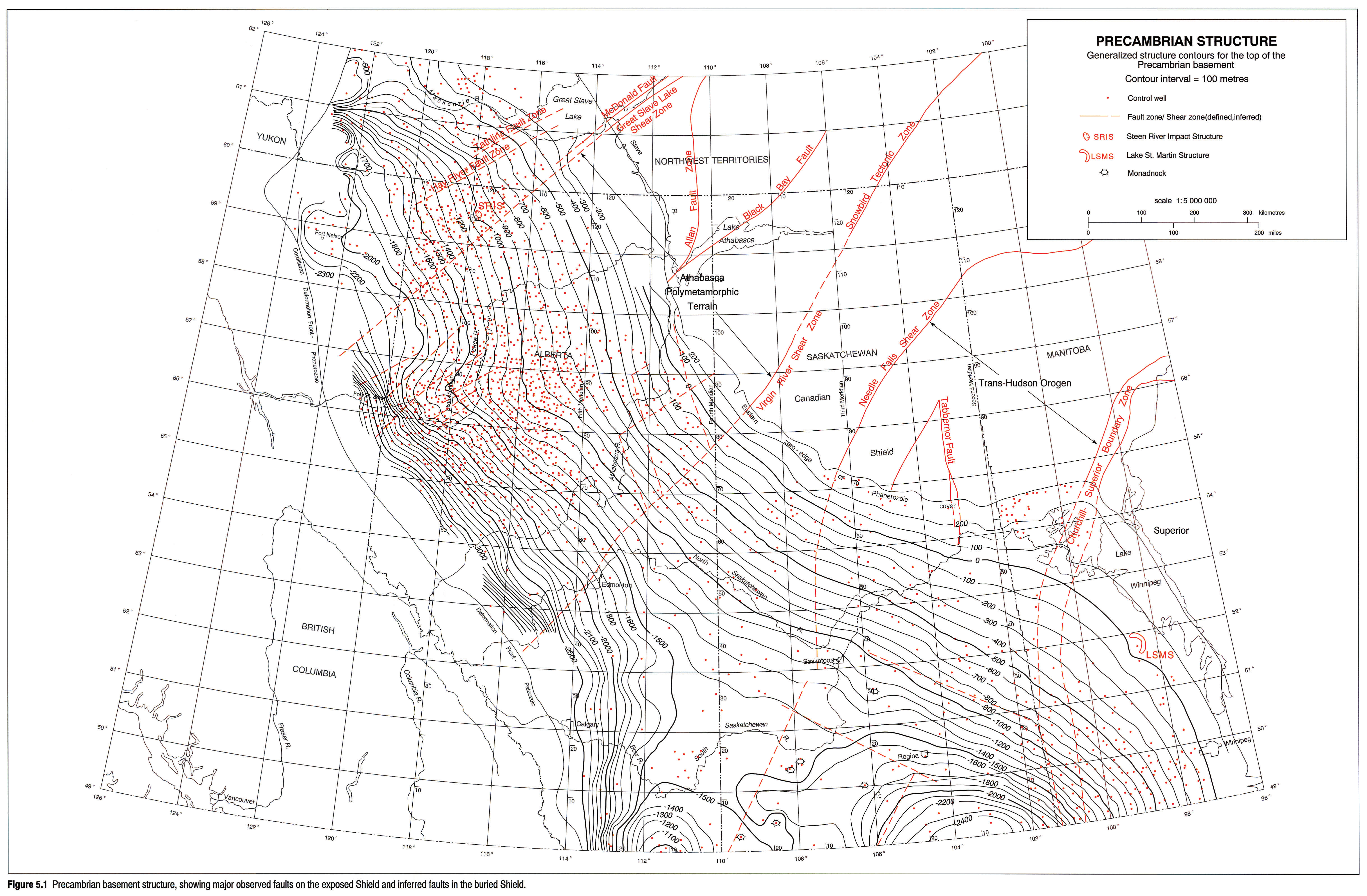
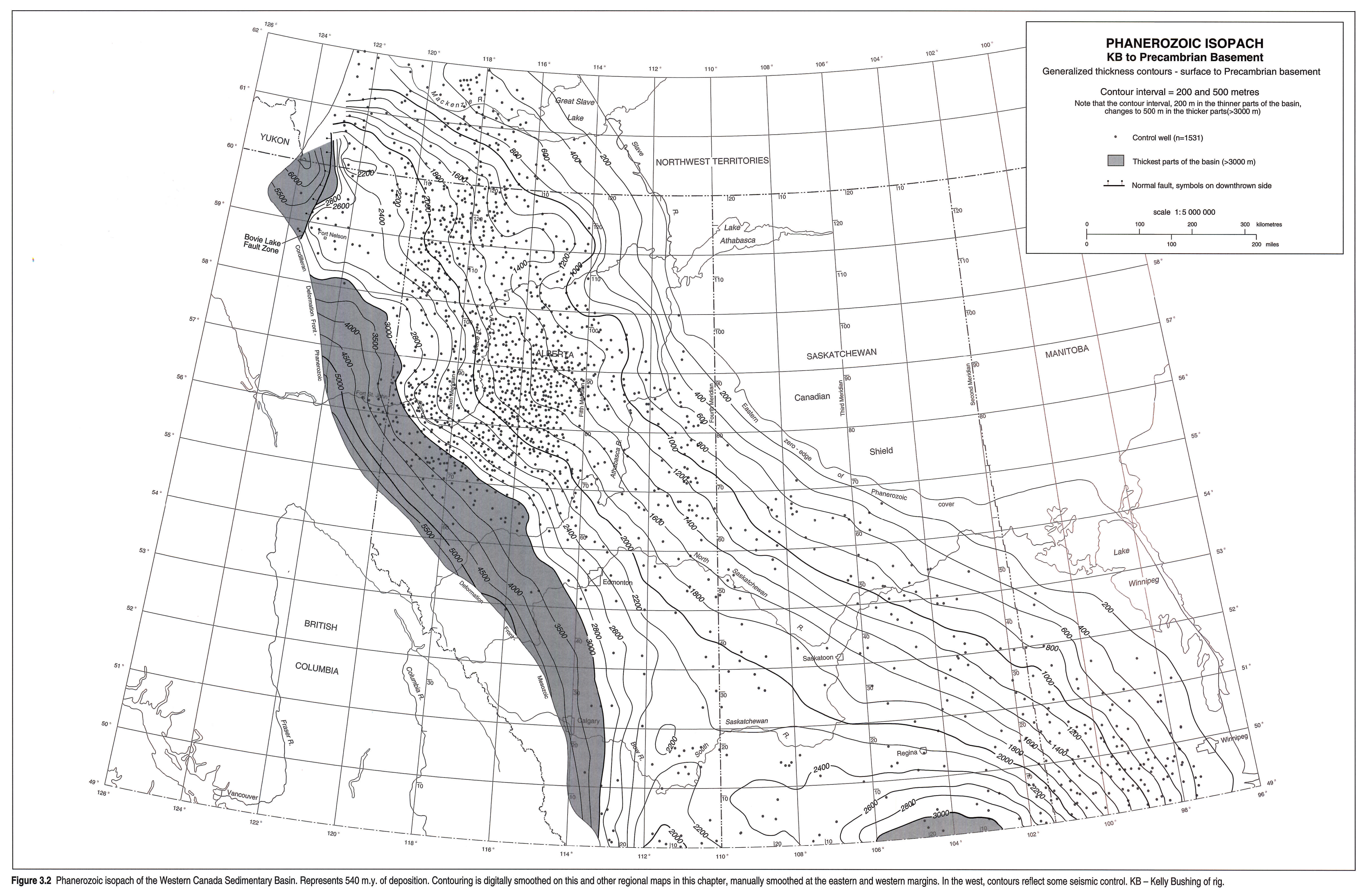
The term "Williston Basin" is arbitrarily applied to the Phanerozoic succession in Manitoba, Saskatchewan, the Dakotas and eastern Montana, but in a structural context it denotes the ellipsoidal depression centered in North Dakota, more or less below the -1500 m contour on the Precambrian basement (Christopher et al., 1973; see Fig. 5.1, this volume). This configuration is a consequence of the Laramide Orogeny. So defined, the basin has a 560 km diameter, an area of some 250 000 km2, and a 4900 m maximum stratal thickness. It extends north into southwestern Manitoba and across southern Saskatchewan as a broad, southeasterly plunging trough, some 3200 m below ground level at the Saskatchewan/U.S. border near longitude 104 °W (see Fig. 3.2, this volume).
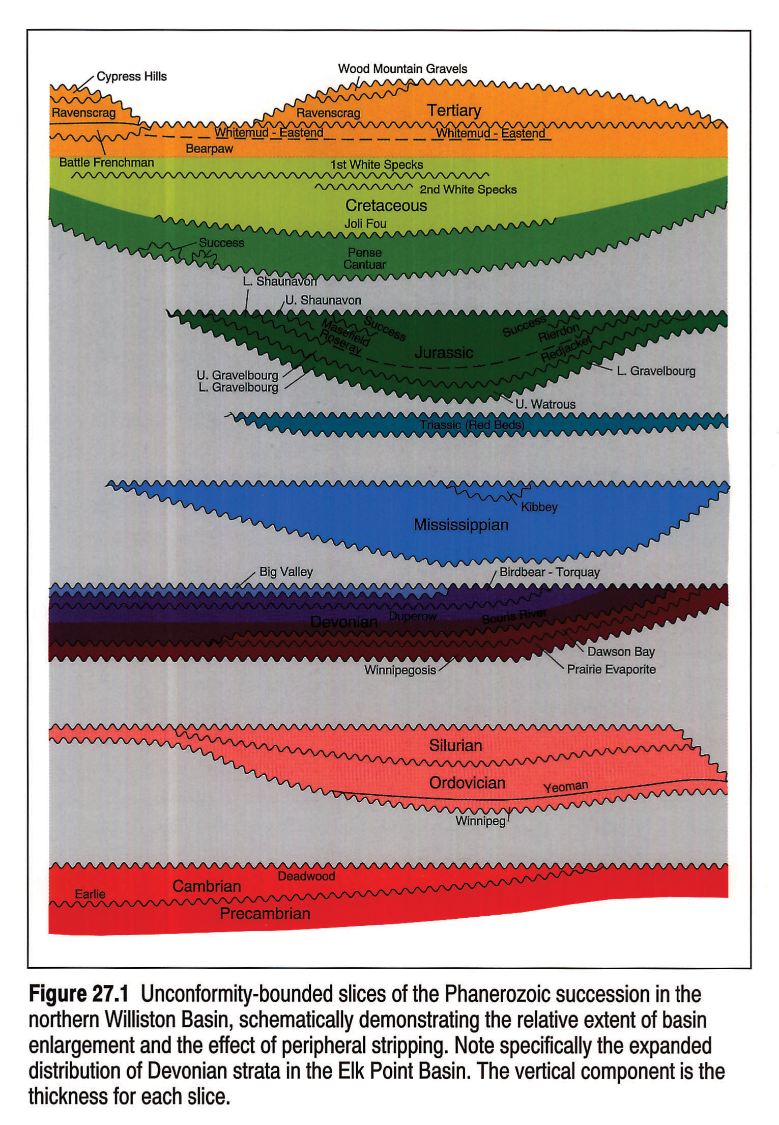
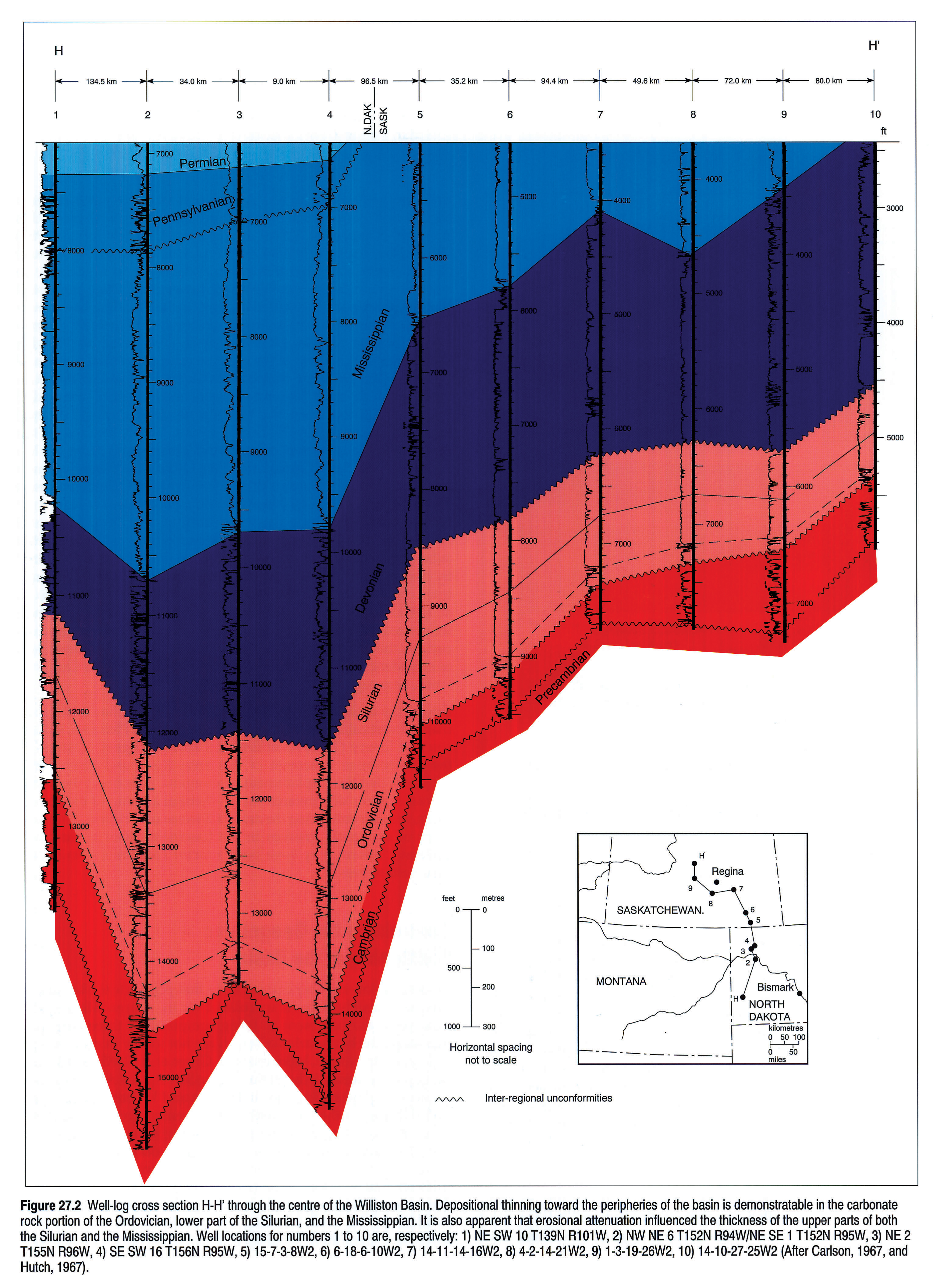
The basin is bordered to the east by the Sioux Arch of the Dakotas and southeastern Manitoba, and to the north by the Punnichy Arch fronting the Saskatchewan monocline. The latter rises at a rate of 2 to 4 m/km northeastward onto the Severn Arch of central Manitoba. The western limit is the Sweetgrass Arch of northern Montana and southeastern Alberta. The structural definition notwithstanding, sedimentary strata of the Williston Basin were laid down in greatly expanded versions of the present basin. These expansions were countered by flanking uplifts and peripheral stripping of strata, imprinting the present configuration on the basin (Fig. 27.1).The net effect is that the Phanerozoic isopach map resembles the structural map. The well-log cross section of Figure 27.2 further illustrates the destructional/constructional phases of development of the basin. In particular, it demonstrates that the basin configuration seen in isopach maps of lower Paleozoic strata (Norford et al., this volume, Chapter 9) is due to peripheral thinning by both erosion and depositional onlap.
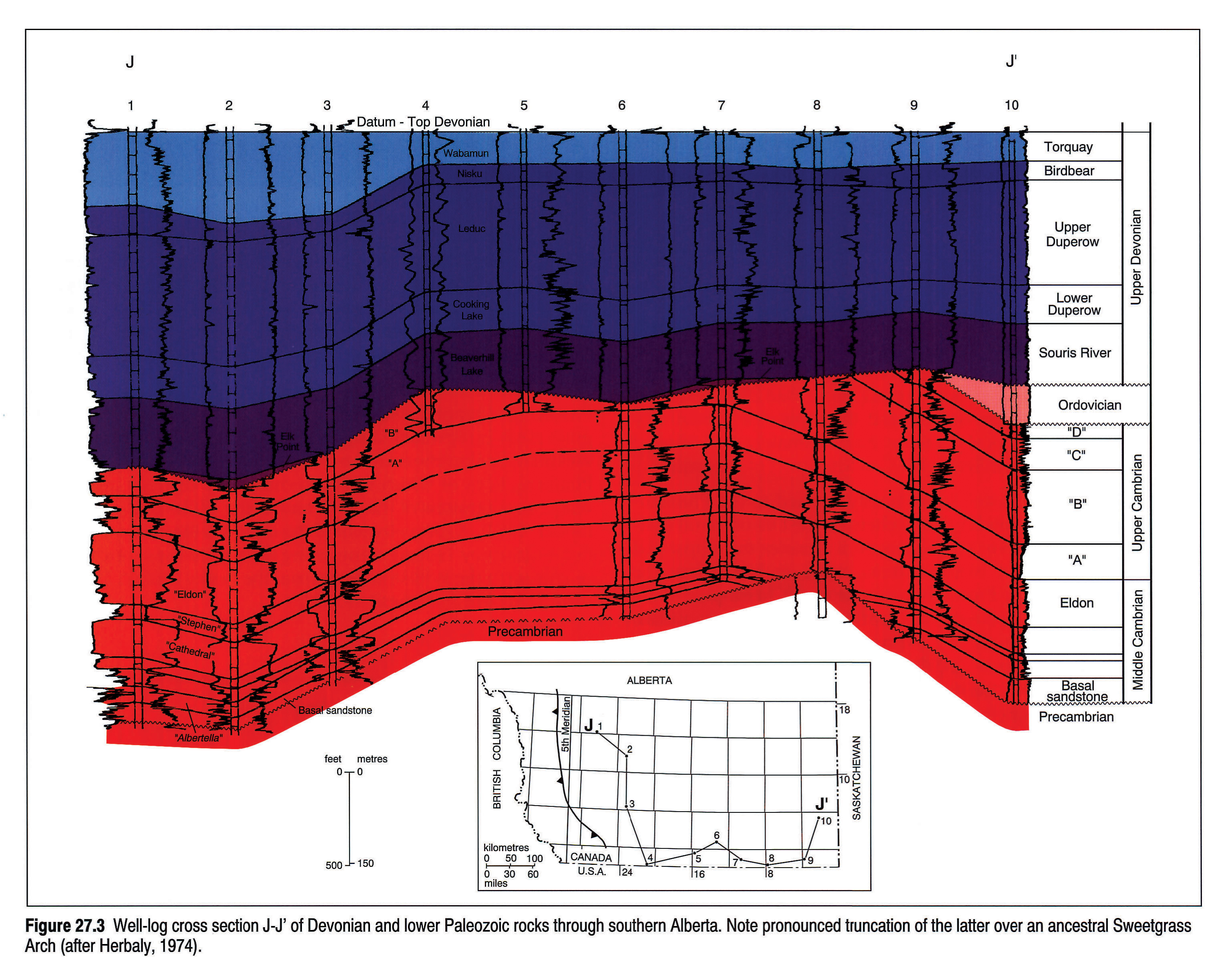
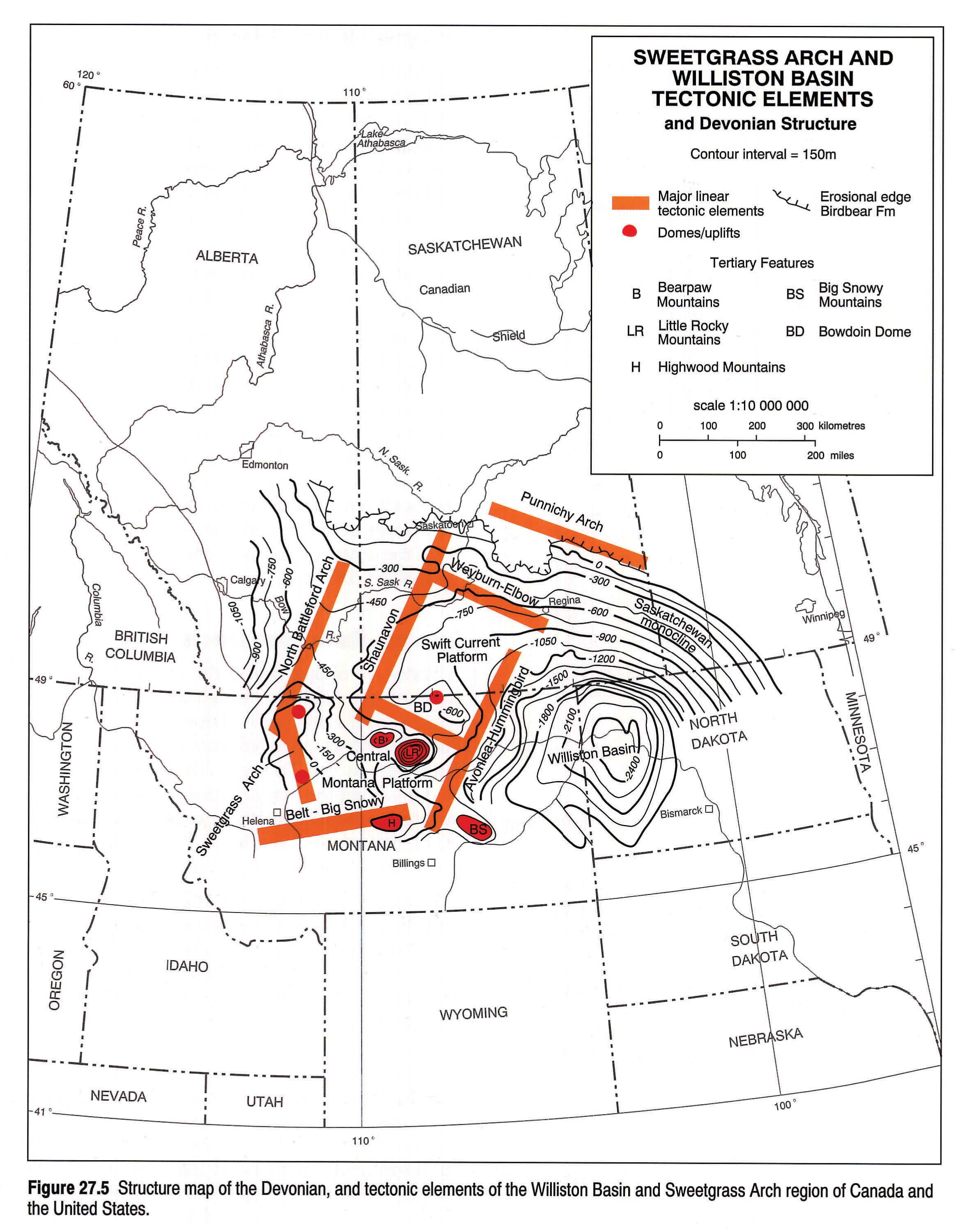
Historically, the Sweetgrass Arch refers to a large structural complex situated in the region of northwestern Montana, southeastern Alberta and southwestern Saskatchewan. Herbaly (1974) demonstrated that the arch may have been active during several stages of geological time. The most intense periods of activity were during the pre-Devonian (Fig. 27.3) and the pre-Jurassic (Fig. 27.4). In its post-Laramide configuration the arch is a northward-plunging compound antiform made up of the South Dome at Great Falls, Montana and the Kevin-Sunburst Dome at the Montana-Alberta border (Fig. 27.5). North of the border, it elongates into a nose overlooking the broad saddle of the Alberta Platform, and rises beyond onto the south-southwesterly plunging North Battleford Arch. As mapped on the Devonian system by Kent (1968), the Sweetgrass Arch is crowded against the steeply dipping and thrusted Rocky Mountain geosyncline to the west. Toward the east the slope falls across Saskatchewan unevenly but more gently around subsidiary domes, terraces and troughs toward the Williston Basin some 500 km away. However the eastern slope in Montana is relieved by domal forms towering up to four times the height of the Arch. These are Late Cretaceous and Tertiary laccoliths represented by the Bearpaw, Little Rocky and Highwood mountains and the nonintrusive Cypress Hills and Bowdoin Dome. This region fronts the northern side of the easterly trending central Montana uplift comprising the Little Belt and Big Snowy mountains.
From a stratigraphic perspective the eastern expanse of the Sweetgrass Arch is represented by the Swift Current Platform of southwestern Saskatchewan and the adjacent Central Montana Platform, both of which have alternated, by upwarp and downwarp, as extensions of the Arch and of the Williston Basin (Christopher, 1990). A third element of the region is the easterly trending Belt-Big Snowy Trough, terminating the arch to the south as a deep re-entrant to the Williston Basin from the Rocky Mountain geosyncline (Peterson and MacCray, 1987).
Focus of the Chapter
In this chapter, the arguments bearing on the origin of the basin are reviewed, as well as its subsidence history and the impact that basin-margin and intrabasin uplifts have had on its sedimentary history. The most influential of these uplifts is the Sweetgrass Arch. Kent (this volume, Chapter 7) shows that the pre-foreland basin phase of the Williston Basin played an integral role in the evolution of the cratonic platform; therefore the chronology of depositional events employed here is the same as that established in Chapter 7.
The early Williston Basin and Sweetgrass Arch were integral components of the western margin of the proto-continent. Two important events in that period were the Antler and Nevadan- Columbian orogenies. Each influenced the pattern of sediment accumulation in the basin. Pre-Antler deposits extended well beyond the present structural limits of the basin. By contrast, post-Antler sedimentation was restricted to the basin and a relatively narrow shelf surrounding it (Kent, this volume, Chapter 7). Antler tectonics may have been responsible for bringing to prominence an ancestral Sweetgrass Arch, over which the depositional strike changed from essentially east-west and parallel to the Belt-Big Snowy aulacogen, to north-northwest along the proto-continental margin (Kent, this volume, Chapter 7). The Nevadan-Columbian Orogeny changed the depositional framework on the western cratonic platform including the Williston Basin (Smith, this volume, Chapter 17) by providing a source for thick successions of siliciclastic sediments, whereas in the pre-Nevadan-Columbian, autochthonous carbonates were dominant.
Origin of the Williston Basin
There are two main aspects to the origin of the Williston Basin: 1) the mechanism of subsidence, and 2) the controls on the geographic positioning of the basin. Some thoughts on the former are presented in the following paragraphs. The latter is considered in the discussion on the framework of the Precambrian basement.
Mechanism of Subsidence
Quinlan (1987) evaluated five mechanisms of subsidence for intracratonic basins, categorized as: 1) a purely thermal process in which lithospheric layers expand and are uplifted during heating, and contract and subside upon cooling; 2) a variation on (1) in which the uplifted crustal rocks undergo erosion prior to the initiation of cooling and subsidence; 3) a second variation on (1) resulting in active rifting and thinning of lithospheric rocks by subcrustal erosion through the action of convection cells within the asthenosphere; 4) metamorphic tranformation of sublithospheric rocks resulting in their densification; and 5) horizontal compressive stresses acting upon pre-existing downwarps, the stresses being transmitted into the interior of the craton from convergent plate margins. Quinlan nonetheless identified deficiencies in each of the mechanisms, particularly where applied to the subsidence histories of the intracratonic basins of North America.
The complex patterns of stratal thickening, thinning and truncation in the sedimentary succession of the Williston Basin, as demonstrated in this and other chapters of this Atlas, may be responses to a combination of mechanisms causing basin subsidence and uplift of the flanking arches. A brief review of the pertinent geological and geophysical information may help to explore this premise. Hajnal et al. (1984) and Morel-a-L'Hussier et al. (1987) showed that a relatively thick crust underlies the basin. Fowler and Nisbet (1985) attributed this crustal thickening to a gabbroic to eclogitic phase transformation of the lower crust. They suggested that the phase change resulted in densification, loading and downward warping of the crustal rocks, creating an ellipsoidal depression. However Morel-a-L'Hussier et al. (1987) also identified a slight thinning (3-5 km) of the crust beneath the central portion of the basin. This evidence corroborates the findings of Crowley et al. (1985) who, through fission-track analysis of apatite, concluded that the Williston Basin had undergone uplift through thermal expansion followed by subaerial erosion, which resulted in the removal of at least 3 km of crustal rocks. This event is dated 572 Ma to 441 Ma (i.e., Early Cambrian to Late Ordovician), and thus may have initiated the basin as a depocentre in North Dakota (Peterson and MacCary, 1987; Lefever et al., 1987). Subsequent cooling may have prolonged basin subsidence through the Ordovician and Silurian and its sphere of influence extended by densification of the subcrustal rocks. Later downwarping may have been perpetuated by horizontal compressional stresses propagated through the cratonic crust from convergent margins (Quinlan, 1987). Doborek et al. (1991) demonstrated that emplacement of the Antler allocthon influenced sedimentation patterns in the Idaho-Montana region as early as the Givetian, and thus may account for the increased rate of subsidence in the basin from Late Devonian through Carboniferous, as recognized by Kominz and Bond (1991).
One of the areas flanking the Williston Basin that has undergone marked vertical fluctuations is the Swift Current Platform. Collerson and Lewry (1985) identified probable anorogenic granites in the Precambrian basement of this area. Klein and Hsui (1987) proposed that the emplacement of anorgenic granites at the flanks of intracratonic downwarps causes thermal arching of the crustal rocks, thereby enhancing the arch to downwarp relation. Emplacement of anorgenic granites in the basement rocks of the Swift Current Platform may have been a factor contributing to its tectonic restlessness.
Controls on the Geographic Positioning of the Basin
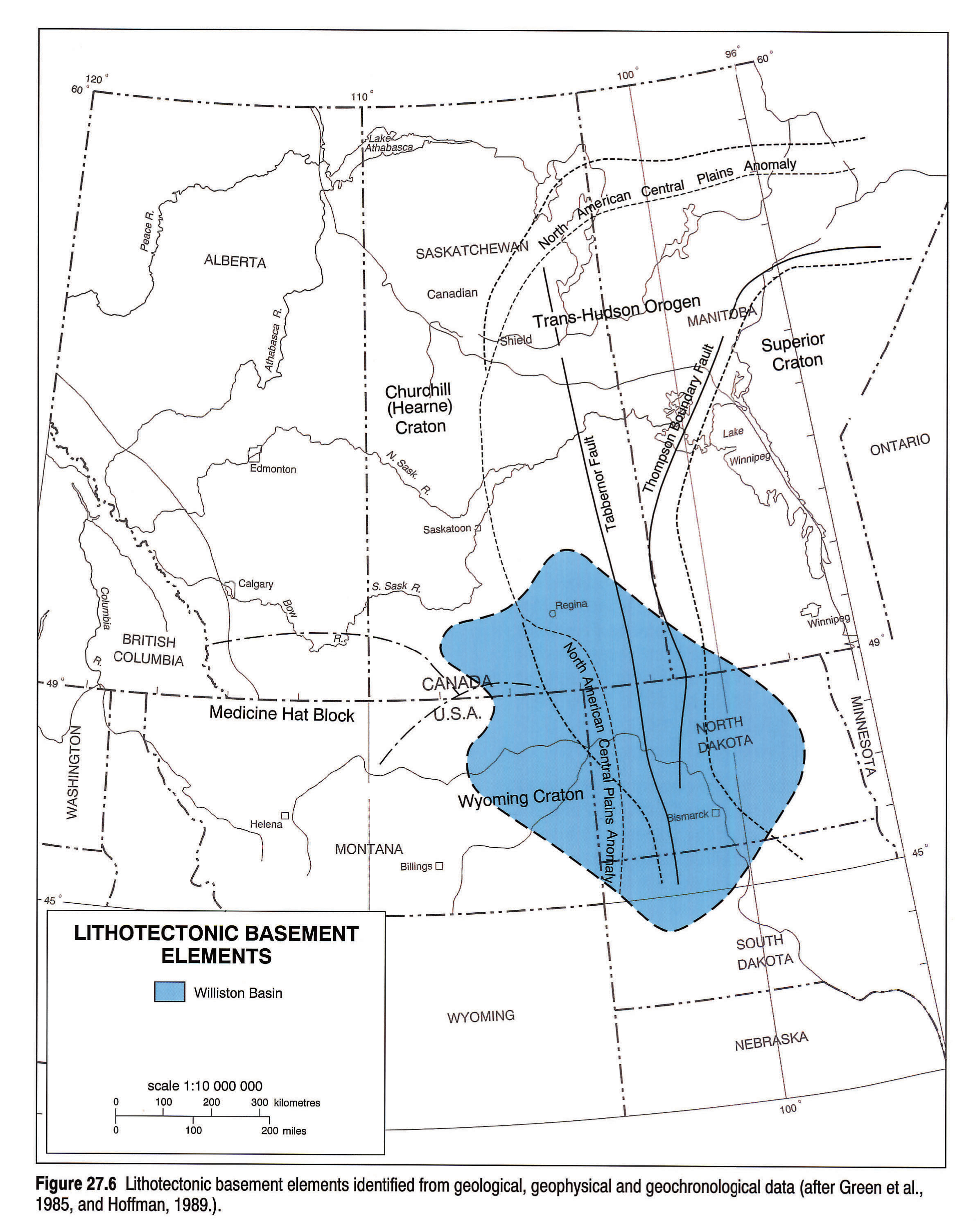
Despite the low number of deep wells that penetrate the basement, various researchers have speculated on its nature. Meek (1958) interpreted the basement as being composed of three structural provinces, the boundaries of which are not totally in concert with those accepted today. More recently, Green et al. (1985) partitioned the basement beneath the basin and the Sweetgrass Arch into three Archean provinces, Superior in the east and Wyoming and Churchill (Hearne) in the west, with an intervening Lower Proterozoic collision zone separating the first from the latter two (Fig. 27.6). They recognized the collision zone as the southern extension of Lewry's (1984) Trans-Hudson Orogen, a continent-to-continent collision suture. Green et al. (1985) demonstrated that several lithotectonic belts and juvenile terranes make up the collision zone. In addition, the north-trending structural grain of the orogen is mimicked by southern extensions of the Tabbernor and Thompson Boundary faults of the exposed Canadian Shield. Hoffman (1989) interpreted the southwestern part of Saskatchewan to be underlain by a separate terrane, the Medicine Hat Block, possibly a component of the Hearne (Churchill) Province. This block constitutes a significant part of the Swift Current Platform.
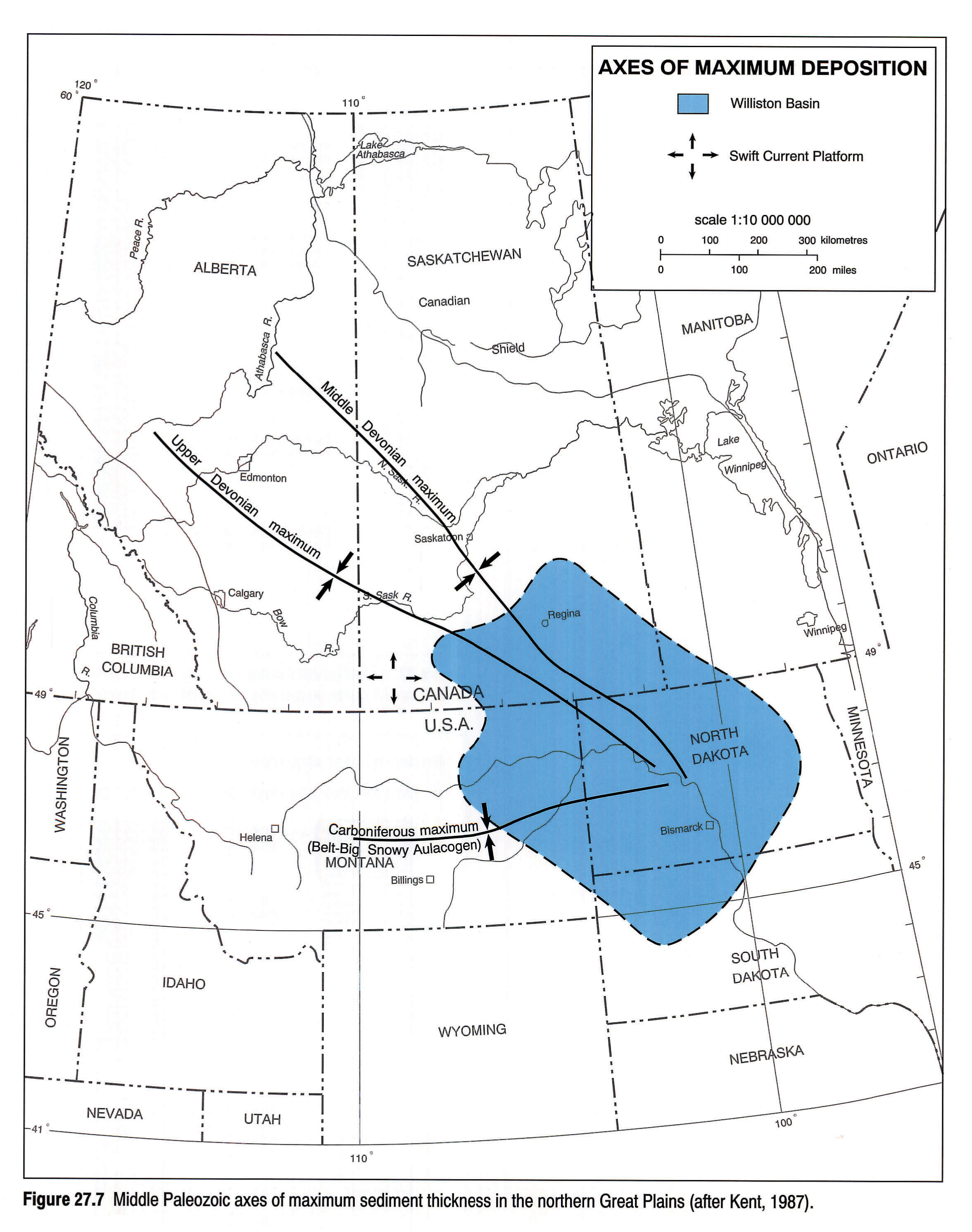
If indeed the foregoing geological interpretations are valid, they may be sufficient reason for the location of the Williston Basin. The abnormal protrusion of the crust into the mantle beneath the basin (Hajnal et al., 1984) may be attributed to the nature of the convergence that created the Trans-Hudson Orogen, and that thickened mass may have been the catalyst for initial basin subsidence. Thus the east-west orthogonal fractures of the basin centre appear to be controlled by the Trans-Hudson Orogen. Likewise, the north-south orthogonal fractures may have been determined by the basin's location at the distal end of the Belt-Big Snowy aulacogen (Stewart, 1972), in which are preserved over 7 km of the Precambrian Belt Supergroup. Additionally, periodic reactivation of the aulacogen during the Phanerozoic, especially in the Cambrian, Mississippian and Jura-Cretaceous has taken place (Fig. 27.7). Thus it would appear that structural features, activated at different periods in the Proterozoic, played significant roles in the geographic positioning of the Williston Basin during the Phanerozoic.
Local Basement Structures
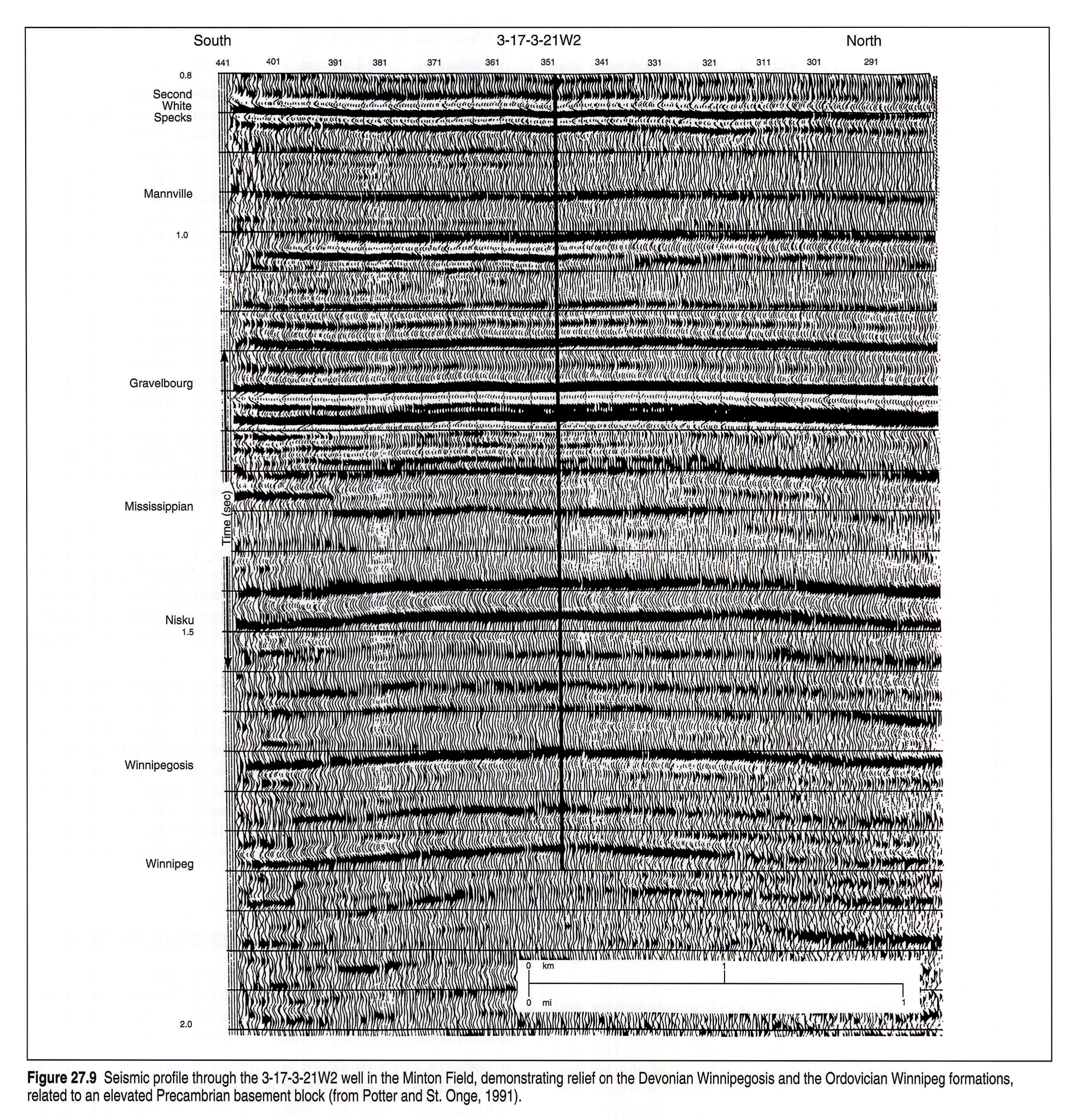
The surface of the Precambrian basement is far from featureless. Sawatzky et al. (1960) identified, through seismic and drill-hole data, ten anomalies, all either proximal to or located on the Swift Current Platform and presumed to be positive features on the Precambrian surface (Fig. 27.8). Most are dome-like and few are more than 13 km2 in area. Although some may be simply resistant erosional remnants, others are probably reactivated fault blocks that controlled facies in overlying strata. The Eastend and Swift Current structures are elongate, and the Elbow Structure is a complex of domes enclosed by a moat-like depression. A few others have been recognized away from the platform, especially in the vicinity of the Trans-Hudson Orogen (Fig. 27.5); for example, near Minton in south-central Saskatchewan (Osadetz and Haidl, 1989; Haidl, 1990; Potter and St. Onge, 1991). Potter and St. Onge (1991) demonstrated that the Minton structure is basement-controlled and was reactivated several times during the Paleozoic. Minton-type structures are most easily identified seismically, through a pull-up of lower Paleozoic reflectors over the structure, particularly those of the Silurian (Byrd, 1978). Figure 27.9 illustrates the relief over the Minton structure on a seismic profile.
The indications are that many of the other basement structures within the structurally defined Williston Basin were episodically activated in the Phanerozoic, including some recognized as being coincidental with or proximal to the trend of the Trans-Hudson Orogen. Most of these basement structures have been identifed in North Dakota (Byrd, 1978; Wilson et al., 1963), but there is also one in southeastern Saskatchewan, at the Workman well 2-34-1-32W1. There, a fault displaces Ordovician strata, but the exact timing of reactivation is not ascertainable, although the Silurian is a good probability. On the other hand, not all reactivated structures coincident with the Trans-Hudson Orogen are found in the structurally defined Williston Basin. Kent (1981) mapped an antiform over the western edge of the orogen on the Lower Cretaceous Mannville coal south of Lac La Ronge in central Saskatchewan, which is suggestive of post-Lower Cretaceous movement in that area. McCabe (1967) identified the Moose Lake Syncline, which incorporates anomalously thick lower Paleozoic strata in proximity to the Thompson Boundary Fault in southeastern Manitoba. It should also be noted that some reactivated structures lie well beyond the orogen. The Battle Creek Dome in the extreme southwest of Saskatchewan appears to have been active in the Late Cretaceous or early Tertiary (Kent, 1968, 1974).
There is also an assortment of orthogonal lineaments coincident with basement structural grain. These are northeast- and northwest-trending in the Churchill (Hearne) and Wyoming provinces and east-trending in the Superior. Some have been recognized at the surface and others as anomalies manifest on isopach maps, or as trends on structure contour maps (Mollard, 1957, 1959, 1987; Christopher 1961, 1964; McCabe, 1967; Kent, 1973, 1974, 1987; Thomas, 1974; Gerhard et al., 1982; Brown and Brown, 1987).
Acting along with, and/or activated by movement of the large structural masses of the Sweetgrass Arch, Swift Current Platform and the Thompson Boundary Fault front of the Superior Province, these subsidiary structures and lineaments shaped important sedimentation and erosional patterns in critical areas. Some of these are as follows.
- The aforementioned Thompson Boundary Fault is coincident with the western margin of the Winnipegosis carbonate shelf and the present eastern solution edge of the Prairie Evaporite in southeastern Saskatchewan and southwestern Manitoba; it is also the site of the pre-Triassic Birdtail-Waskada structural high that separates the Watrous Basin from the Amaranth sub-basin. Thinning of Paleozoic strata in the same general region suggests that the structure had a long history of Phanerozoic reactivation.
- The Shaunavon Syncline is a north-south graben that demarcates the eastern flank of the Sweetgrass Arch in southwestern Saskatchewan from the Swift Current Platform to the east, and likewise terminates the Middle Jurassic Shaunavon sandstone facies to the east and the Upper Jurassic Roseray sandstones to the west.
- The east-west Kindersley Arch, is a western counterpart of the Punnichy Arch and was down-set during an early Laramide foundering of the Swift Current Platform. A Jura-Cretaceous structural and topographic high, its draped structures contain Bakken, Success, basal Mannville and Viking oil and gas fields.
- The Hummingbird-Avonlea north- northeasterly-trending fault group marks the site of multi-stage salt solution structures and the location of oil-bearing upper Paleozoic reservoirs.
- The Elbow-Weyburn lineation is a northwesterly trending element fronting the the Swift Current Platform to the east, along which lies not only the eastern margin of the Middle Devonian Winnipegosis carbonate shelf but also the southwestern edge of the overlying Prairie Evaporite salt mass. The surface expression of the lineament is apparently the Missouri Coteau.
- The Punnichy Arch is an east-southeasterly trending monoclinal flexure along which Phanerozoic strata are sharply downwarped toward the Williston Basin. Like the Kindersley Arch, it forms the erosional front of the Mississippian carbonates, as well as the northern solution front of the Prairie Evaporite salt beds in eastern Saskatchewan. Up-arching associated with the Early Cretaceous downwarp of the Swift Current Platform caused severe truncation of the Mannville across it. The Punnichy Arch is offset from the Kindersley structural terrace by the Elbow-Weyburn lineation.
Structural Control of Phanerozoic Sedimentation
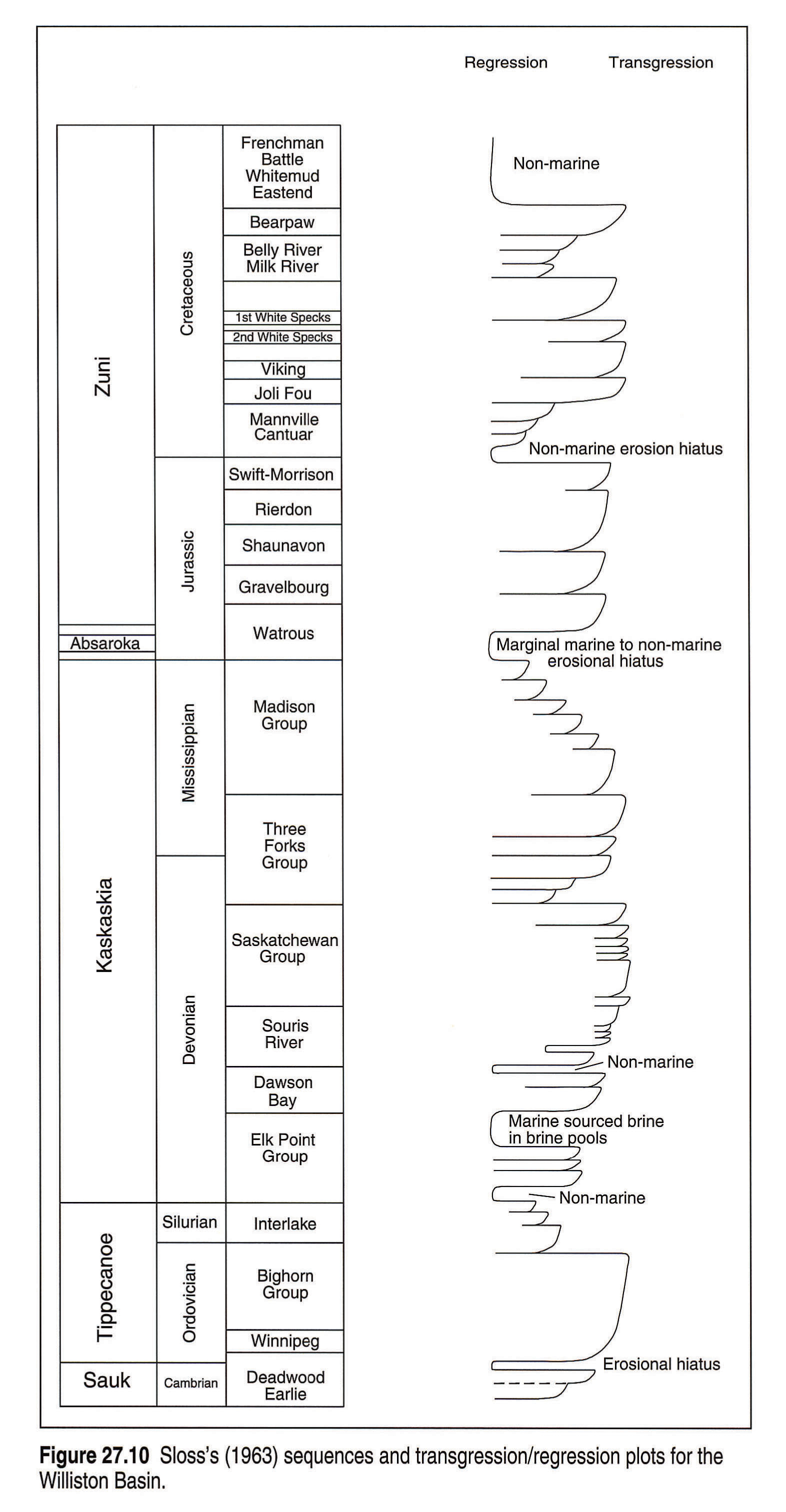
Temporal configuration of the Williston Basin seems to have followed cycles of contraction and expansion since the beginning of its sedimentary record in the Middle Cambrian. These are depicted by the sedimentation and isopachous patterns of Sloss's (1963) unconformity-bounded sequences (Fig. 27.10), and are coincident in part with the major Phanerozoic orogenic and epeirogenic events of the continent. These events are the Middle to Late Ordovician Taconian, Late Silurian to Early Devonian Acadian and Permo-Pennsylvanian Alleghanian orogenies of the eastern and southeastern continental margin; the Late Devonian to Mississippian Antler Orogeny to the southwest, and the Jura-Cretaceous Nevadan-Columbian Orogeny; and the Late Cretaceous-Cenozoic Laramide Orogeny of the western margin. Early Paleozoic events in the Williston Basin appeared to have paralleled those of the Hudson Bay Basin (Sanford, 1987).
Each event appears to have affected the region in the following manner (Christopher, 1990):
- an antecedent downwarp and expansion of the Williston Basin and opening of the Belt-Big Snowy aulacogen at a rate exceeding sediment supply;
- uplift of the elements of the flanking extended Sweetgrass Arch and a concomitant basinward infill by progradational sediments;
- epeirogenic uplift with erosional cycles spreading from the uplifted blocks to the basin;
- tectonic relaxation and encroachment of basin fill onto the flanks of the uplifts as part of a regional transgression.
Cambrian Interval
Although Cambrian sandstones and shales are the first of the Phanerozoic strata to reflect the existence of the Williston Basin by curvature of its isopachs (Slind et al., this volume, Chapter 8; Lefever et al., 1987; Peterson and MacCary, 1987), the formations thicken westward across a submerged Sweetgrass Arch toward a major depocenter in the Rocky Mountain geosyncline. Apart from sandstones reflecting a Precambrian shield source, Cambrian facies form northerly oriented belts from eastern Saskatchewan to the western geosyncline, and typically grade from nearshore sandstone bodies in the east to shallow-water shelf carbonates in the west (Kent, this volume, Chapter 7). The system is capped by an unconformity (Figs. 27.1, 27.10) representing a global drop in sea level.
Ordovician-Silurian Interval
The Middle Ordovician Winnipeg Formation also thickens into the Williston Basin but its distribution is opposite to that of the Cambrian in that it wedges out westward from Manitoba along an irregular, northerly oriented edge overlapping the Deadwood in western Saskatchewan (Norford et al., this volume, Chapter 9). Vigrass (1971) suggested that the Winnipeg Formation is an infill of a topographic depression on an eroded Deadwood Formation.
The isopachs of the succeeding Ordovician and Silurian carbonates and subsidiary anhydrites mirror the form of the Williston Basin (Norford et al., this volume, Chapter 9).
However, none of these formations feature facies patterns that reflect paleobathymetry (Kent, 1987 and this volume, Chapter 7); although the evaporites, found at various stratigraphic levels, imply a basin-centre location. Each evaporitic unit is part of a "brining-upward" sequence idealized in Figure 27.11. On the other hand, Jamieson (1973) showed that in the Silurian Interlake Group there is a facies change from tidal-flat deposits along the eastern and northern margins of an enlarged Williston Basin to subtidal carbonates in the central part. Progradation of peritidal facies toward the centre of the basin and eventual emergence are indicated (Magathan, 1987).
Devonian-Mississipian Interval
A hiatus involving nearly the whole continent (Figs. 27.1, 27.10) spanned the Middle Silurian and Early Devonian. Middle Devonian sediments were laid down in a northwesterly elongated Elk Point Basin that extended from northwestern Alberta to the Williston Basin in the Dakotas. The presence of accreted carbonate wedges along the margins and deep-basin deposits enclosing carbonate buildups toward the centre, indicate typical basin control (Kent, this volume, Chapter 7). Basin infill was completed with the deposition of halite and potassium salts.
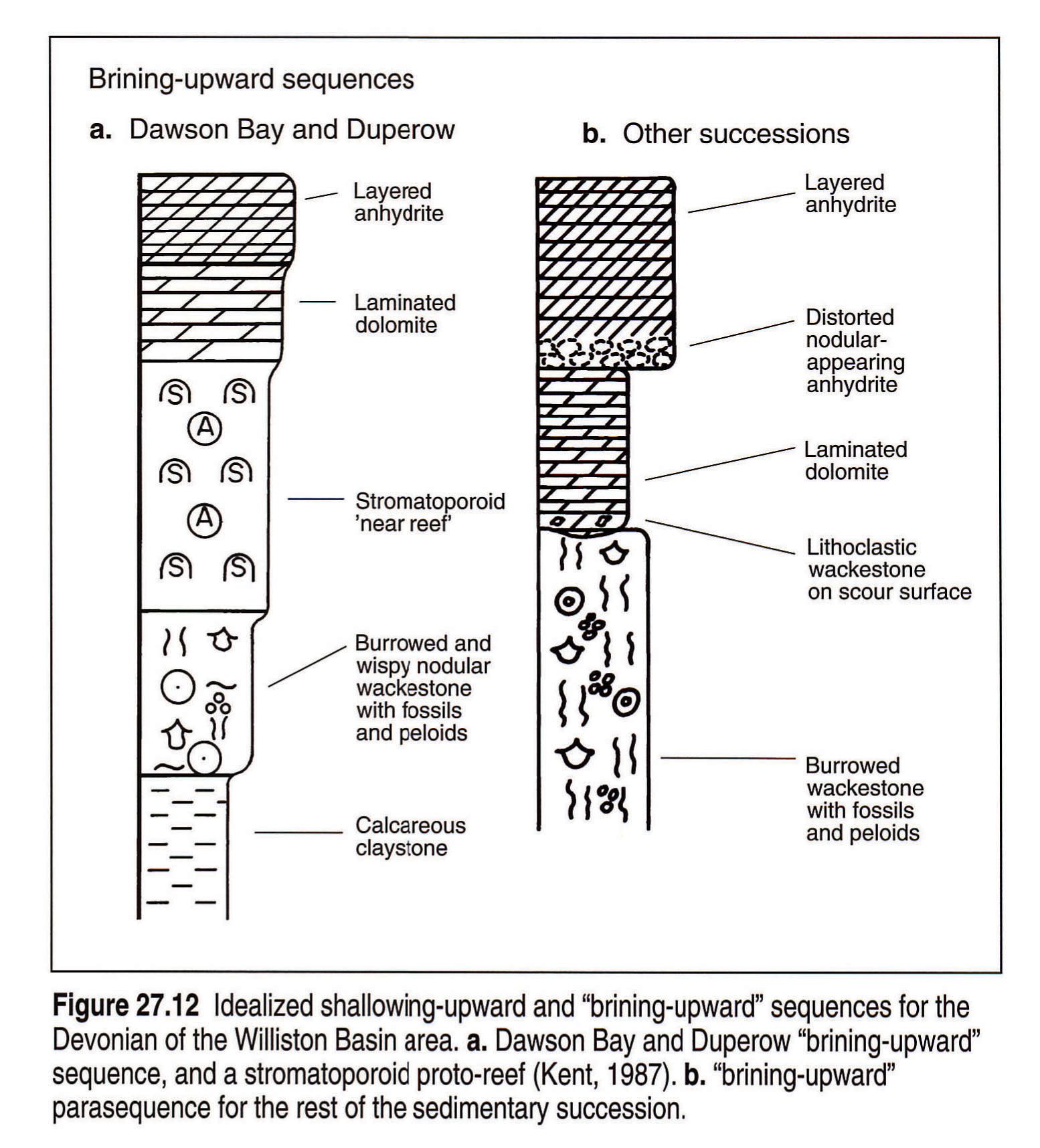
The seaway expanded onto the the Sweetgrass Arch during the Middle and Late Devonian and sedimentation during that time was characterized by cyclic carbonates and evaporites. Although axes of maximum sedimentation similar in trend to that of the Middle Devonian are evident (Fig. 27.7), basin control of the sedimentary facies is not. Thus Upper Devonian sediments, from the Williston Basin to eastern and southern Alberta, were deposited in a shallow seaway, in which the shelf break was at the Killam marginal reef complex of central Alberta. Cyclic ordering of stratal types from shelf carbonates to evaporites, identifiable as shallowing-upward and "brining- upward" parasequences (Fig. 27.12), are the norm south and east of that complex. By the end of the Devonian, sedimentary types became dolomitic-evaporitic with included redbeds, succeeded by argillaceous and sandy strata transitional into strata of the Mississippian (Christopher, 1961). These strata may reflect initiation of the Antler Orogeny.
The last of the Paleozoic transgressions began with the spread of Kinderhookian and Osagian carbonates across the Sweetgrass Arch and waned in a series of shallowing-upward parasequences (Fig. 27.10), marked by gradual retreat of Meremecian and Chesterian strand plains annular to the Williston Basin and the Belt-Big Snowy Aulacogen of Montana. The Mississippian strata best display the control of carbonate facies distribution by Williston Basin paleobathymetry. The peritidal and shelf facies are annular to the basin and flank both sides of the Belt-Big Snowy Trough. The deeper water carbonates are basin centred and lie along the axis of the trough.
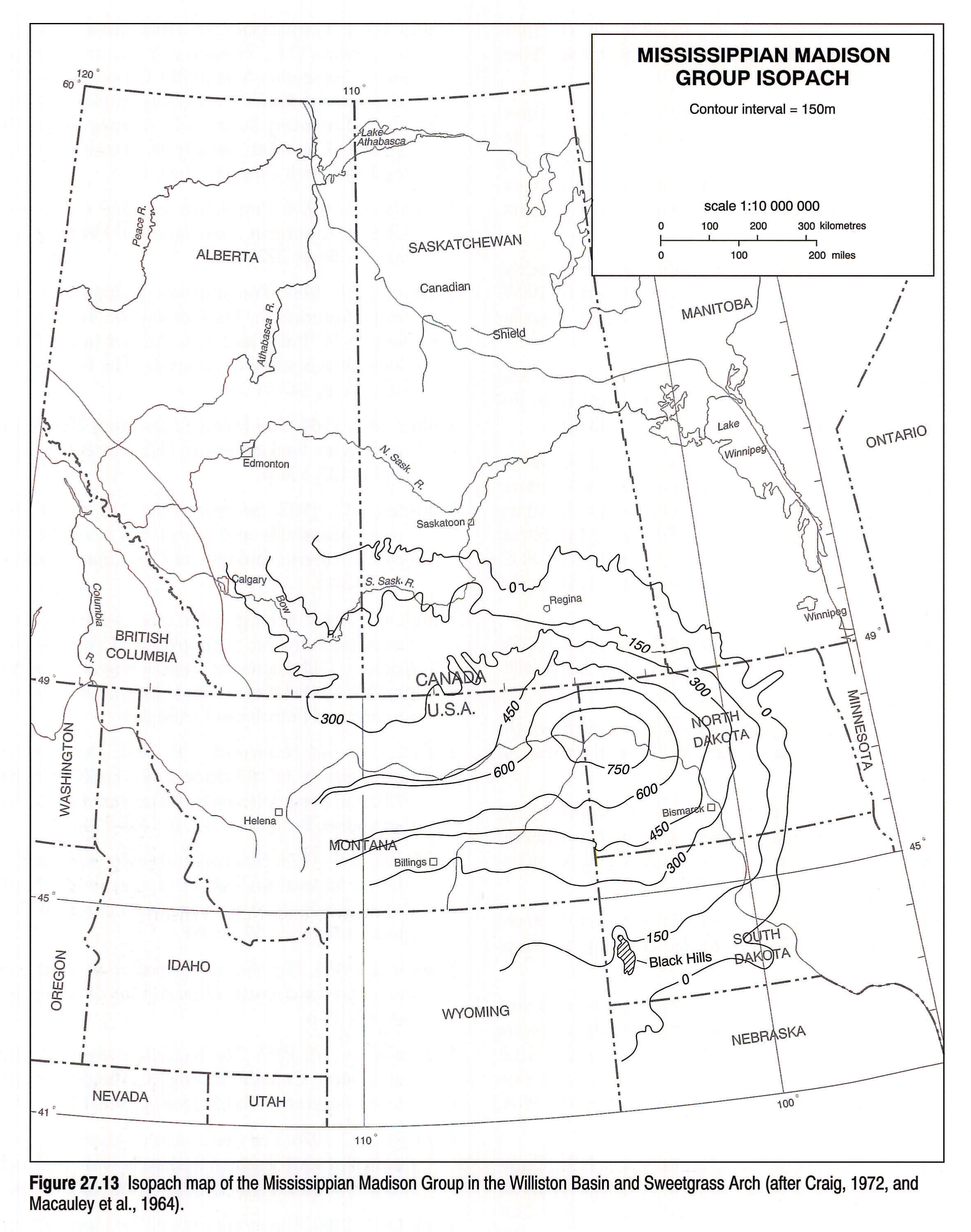
In general the Mississippian isopachytes (Fig. 27.13) mirror the configuration of the depositional floor. Kinderhookian carbonates once extended farther to the north of their present edge. Basin geometry is indicated by broadly spaced isopachytes, between 0 and 300 m of shelf limestones extending from Manitoba across the antiform of the Sweetgrass Arch, and to the Swift Current Platform of southwestern Saskatchewan, and by the annular configuration resembling the post-Laramide structural basin.
The sequence closes with Pennsylvanian sediments, restricted to the central area of the basin. Apparently none of these were deposited on the arch or on the flanks of the present basin in southern Saskatchewan and southwestern Manitoba.
On the crest of the Sweetgrass Arch in Alberta and western Montana Mississippian strata are overlain by those of the Middle Jurassic. On the flank in Saskatchewan, and extending into Manitoba, Triassic redbeds intervene. However in the east, on the Severn-Sioux Arch of Manitoba and the Dakotas, the erosional hiatus was greater, and the entire Paleozoic section is absent from the arch. In places the redbeds of the Triassic Amaranth Formation of Manitoba rest directly on Precambrian rocks (McCabe, 1971). Deeper into the basin, in North Dakota and eastern Montana, the hiatus below the Triassic was not so extensive, and 500 m of Upper Mississippian, Pennsylvanian and Permian carbonates, evaporites, black shale, channelled sandstones and redbeds are present. Upwarp of the Saskatchewan shelf and Sweetgrass Arch had by then eliminated the Elk Point Basin, even as concomitant downwarp accentuated the Williston Basin and the Belt-Big Snowy Aulacogen. A measure of the tectonic relief between arch and basin is given by the maximum amount of eroded sediment; that is, about 600 m (Christopher, 1984a).
Triassic Interval
The Triassic terrain differed sharply from its predecessors. Sediments are redbeds in Saskatchewan and Manitoba, and redbeds, carbonates and evaporites in the Dakotas and the extreme east of Montana. The basin featured two main elements (Fig. 27.14):
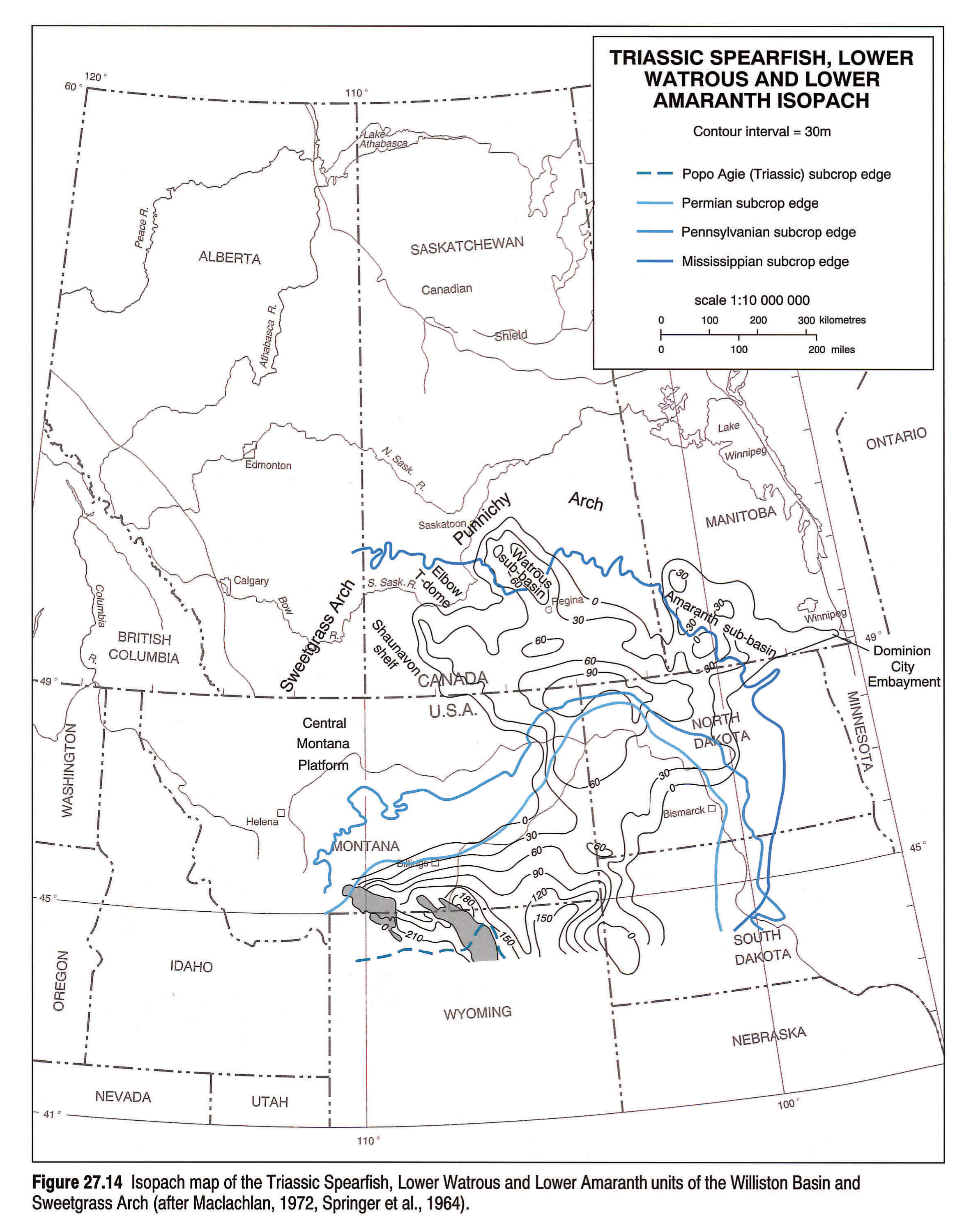
- a northeasterly trending rectangular trough extending from northern Wyoming across the center of the structural Williston Basin to southwestern Manitoba, where it formed the Amaranth embayment;
- a similar but broader trough projecting northwest from the Williston Basin center into Saskatchewan.
The orthogonal fractures, dominated by northwest and northeast sets, with subsidiary east and north sets, indicate a static tensional control. The east-west Belt-Big Snowy Aulacogen was closed and tectonic mobility is indicated only south of latitude 46 °, where the Spearfish thickens markedly into Wyoming.
Widespread erosion of the Sweetgrass Arch resulting from Permo-Triassic Alleghanian uplift sculptured the resistant, basinward-dipping Mississippian and Devonian carbonates into cuestas, breached by wind and water gaps (Martin, 1966). Uplift of the arch also facilitated the selective removal of halite from the Devonian evaporitic beds lying at depth, and thereby contributed to structural depressions on the Triassic depositional terrain. First-cycle erosion inverted the topography, so that structural domes became Watrous-infilled topographic basins and structural depressions became topographic domes with only a veneer of Watrous sediments or none (Christopher, 1961, 1984a). An example of this phenomenon is provided by the Watrous embayment of the Punnichy Arch, and is suggested in Figure 27.14 by the northerly protrusion of Watrous deposits across the southerly arc of the Mississippian erosional front. A similar cuesta, wind and water gap topography was developed in Mississippian carbonates on the western slope of the Severn-Sioux Arch in Manitoba. In addition, a major east-west valley called the Dominion City Embayment and filled with Amaranth redbeds, traverses the entire Paleozoic subcrop of south-central Manitoba (McCabe, pers. comm.).
The crest of the Sweetgrass Arch in southeastern Alberta was similarly breached by an eastward-flowing drainage system, the eastern half of which crossed the Shaunavon Shelf of Saskatchewan as the Adams Creek re-entrant (Christopher, 1964). The upper reaches of the valley were not fully transgressed until late in the Middle Jurassic. This is true also of other valleys on the Arch, such as that on the saddle in the Medicine River area of southern Alberta (Hopkins, 1981). The eastern flank of the Arch across the Shaunavon Shelf featured monoclinal terraces that downstepped toward a depressed Swift Current Platform. This combination of topographic and structural elements exercised a strong influence on local and regional depositional formats in the succeeding Jurassic basins.
Jurassic Interval
Middle Jurassic strata feature a stratigraphic transition from the restricted-basin evaporites of the Upper Watrous to the more open-marine, dark green fossiliferous shales and buff limestones of the Gravelbourg and Shaunavon formations (Reston and Lower Melita of Manitoba). The Middle Jurassic Williston Basin resembled the Triassic in the retention of northeasterly and northwesterly trends, but much of the earlier relief was infilled, leaving a nearly flat floor on the upper units. The depositional centre apparently shifted east of the Swift Current Platform in Saskatchewan, where the Middle Jurassic is some 150 m thick (Poulton, et al., this volume, Chapter 18). On the other hand, relief on the arch and the central Montana Platform is strongly delineated by virtue of incomplete onlap.
The Callovian and Oxfordian seas completed the onlap of the southern part of the Sweetgrass Arch. Shales and sandstones were laid down as prograding sediments in a basin that underwent episodic deepening and expansion at a rate exceeding initial sediment supply. A concurrent uplift of the Swift Current Platform accompanied a shift of the Williston Basin centre from southern Saskatchewan to western North Dakota and eastern Montana, and its shape and position approximated more nearly the Laramide structural form.
Reformatting of the Williston Basin is coincident with the beginning of the Nevadan-Columbian Orogeny, in a manner similar to that of the Early Mississippian basin that heralded the Antler-Alleghenian events. Likewise, as before, the Belt-Big Snowy Aulacogen reopened to accommodate an extra thickness of Upper Jurassic marine Swift to continental Morrison sediments.
Jura-Cretaceous Subinterval
Termination of the marine Jurassic basin came in the Late Jurassic and the pre-Aptian Cretaceous by progressive uplift of the Precambrian Shield (Christopher, 1984b). Erosional stripping of the terrain from north to south in the manner initiated in the Triassic resumed. The humid climate of that time deeply weathered the bordering Precambrian granitic and syenitic terrains and introduced a quartz-kaolin component to the renewed, dominantly fluviatile, sedimentary influx. Chemical weathering also attacked the cherty Mississippian limestones exposed on the arches, releasing tripolitic debris for accumulation in topographic depressions of the breached anticlinal uplifts.
Cretaceous Interval
Neocomian uplift and dissection of the Swift Current Platform and the Sweetgrass Arch ensued. The resulting highlands were dissected to depths greater than 120 m and master streams radiated off to the sea in northern Alberta (see Hayes et al. this volume, Chapter 19). Albian tectonic relaxation led to subsidence of the extended Sweetgrass Arch and burial under a southwestern-sourced fluviatile influx from the rising Rocky Mountain uplifts, which encroached upon a Mannville seaway and estuarine basin reminescent in geographic layout of the Middle Devonian Elk Point Basin.
The massive drowning of the Williston Basin region by the Cretaceous seas recalls those of the early and middle Paleozoic. As in the Devonian, events were multi-cyclic, except that the sedimentary influx was clastic and directly related to events in the flanking Rocky Mountain Foreland Basin. This history is treated in the chapters on the Cretaceous (Hayes, et al. and Smith, this volume, Chapters 17, 19). However it is worth noting that the depositional center of the Williston Basin region during the Early Cretaceous had shifted to southwestern Saskatchewan and adjacent Montana; that is, over the depressed Swift Current and Central Montana platforms.
Like its orogenic predecessors, the Laramide Orogeny restored the semi-elliptical form of the Williston Basin and its centre to western North Dakota. The present post- orogenic landscape exhibits much of the same landform distribution as those of the Early Cretaceous and the Triassic, and the major streams follow many of the courses of their distant ancestors. Conversely, the respective shoreline deposits do not coincide spatially. A new factor was Laramide intrusive activity on the southern part of the Sweetgrass Arch and Central Montana Platform, which reflected encroachment of the western orogen onto the arch.
Local Structures and Sedimentation Patterns
The influence of local structures is reflected primarily in the thickening and thinning and facies differentiation of strata. The activity of such structures is identifiable because they were positive or negative during specific periods of sedimentation.
For instance, in southeastern Saskatchewan, oolite accumulations of the Ordovician Red River Formation (Kent,1960; Andrichuck, 1959; Kendall, 1976) apparently reflect the influence of the Thompson Boundary Fault (Green et al., 1985; McCabe, 1967). Moreover, this structural element appears to have been active during 1) deposition of the Middle Devonian Winnipegosis, causing the separation of an eastern shelf of shallow-water carbonates and reefs from a central basin of deeper water deposits with only isolated reefs and banks; and 2) Early Mississippian deposition of the Middle Bakken when north-south-aligned shoreline sands were deposited along its western flank (Christopher, 1961).
Brown and Brown (1987) identified a number of linear elements in the American part of the basin that controlled Phanerozoic sediment accumulation. Specifically, they considered some blocks bounded by conjugate lineations as sites of carbonate grainstone accumulation in the Mississippian. Local structures, such as that at Minton, can also be sites of structurally controlled facies development. According to Potter and St.Onge (1991) Winnipegosis coral-stromatoporoid patch reefs within the accreted shelf carbonates are found on the Minton structure. Indorf and Norwood (1983) also have demonstrated structurally controlled facies in the Medicine Lake field immediately south of Minton in northeastern Montana.
Salt Solution Tectonics
Most sites of negative bathymetry are situated where Middle and Upper Devonian salt beds are anomalously absent or thin. These appear in the isopachs of overlying strata as corresponding thicks. In the Upper Devonian Duperow Formation Kent (1968, 1973, 1974) noted that northwesterly oriented isopach thicks in the present salt-free area of western Saskatchewan end at seismically delineated circular positive structures, and concluded that both of these originated in the basement. Some of the linear salt solution trends have been identified as sites of multistage salt removal (Christopher, 1961; Wilson et al. 1963; Anderson and Hunt, 1964; Parker, 1967; Smith and Pullen, 1967; Swenson, 1967; Holter, 1969). These are recognizable in the stratigraphic section by offsets of isopachous thickening from one horizon to another, and by stratigraphic inversion of thicks and thins. Thus a thinned bed may drape a structural high formed by a subjacent thick.
The simplest large-scale expression of structure related to the presence or absence of a salt mass is the drape of younger strata over the Prairie Evaporite outlier forming the Roncott high in extreme southern Saskatchewan and the stratal depression of the Elbow sub-basin at the apex of the "No Salt" area southwest of Saskatoon (Christopher, 1961). Another type is the drape of superjacent strata over the crest of the northern front of the salt solution scarp of the Prairie Evaporite at the Punnichy Arch.
Whereas facies changes across salt solution sinks are not commonly recorded, these have been also observed; for example, at the Tidewater Birsay 13-4-25-8W3 well, where in the Upper Devonian Birdbear Formation an anomalous thickness of laminated carbonate and kerogenous mudstone replaces the regional shelf carbonate. Likewise, Hartling et al. (1982) showed that the Mississippian Ratcliffe beds in the Hummingbird sink are more micritic than outside. Another type of solution-controlled sedimentary pattern is the coincidence of basal Mannville deposits with valleys on the sub-Cretaceous unconformity that link lacustrine depressions associated with salt sinks (Christopher, 1984b).
Facies, Structure and the Economic Mineral Deposits
Hydrocarbon accumulations in pre-Mississipian rocks are associated with 1) local basement flexures, 2) Middle Devonian reefs, and 3) multistage salt-solution structures. Deeper in the basin of North Dakota and Montana, structures originating in the basement can be quite large; for example, the Nesson and Cedar Creek anticlines, which are 45 km or more long, and support an array of oil fields. The smaller structures known to exist on the Canadian side of the basin facilitate the formation of reservoirs in the overlying carbonates through the creation of fracture-controlled porosity, enhanced dolomitization (e.g., the Hummingbird Field-Nichols, 1970) or the development of grainstone or reef reservoirs on structurally induced paleobathymetric highs.
The major oil-producing region of southeastern Saskatchewan is an integral product of Williston Basin tectonics. Lying at the updip end of the annular facies laid down in the Mississippian basin, these reservoirs are sourced from bituminous basal carbonates below the oil window, which were deposited in the depocentre when it was subsiding at a rate exceeding sediment supply. Stratigraphic traps owe their presence to intertonguing of evaporites and skeletal and nonskeletal calcarenites and lime mudstones. The southerly dipping anhydrites form top and bottom seals and have acted as baffles channelling migrating hydrocarbon-bearing fluids toward the updip sub-Triassic unconformity (Christopher, et al., 1973). Lateral limits of individual reservoirs are set by permeability decreases along strike, and by paleotopographic relief on the erosion surface. Paleotopographic hills may also coincide with structural highs.
The Shaunavon graben, or more properly half-graben, separating the Shaunavon monocline on the eastern flank of the Sweetgrass Arch from the Swift Current Platform, is pivotal to the oil and gas district of southwestern Saskatchewan. It is the site of the Middle Jurassic Shaunavon oilfields perched on the terraced walls of its southwestern flank, and Upper Jurassic and Lower Cretaceous reservoirs offset to the north at higher elevations and stratigraphic levels. The graben occupies a zone of weakness controlled by a pronounced northwest-trending fracture system.
The Upper Shaunavon west-to-east facies transition from coastal sandstones and carbonates, comprising the reservoirs, to offshore nonreservoir mudstones and marlstones traps the Shaunavon oil reserves downdip along a north-trending belt. The Upper Jurassic Roseray sandstone-shale transition is again north-south-trending and oriented along the graben, but from east to west. Hydrocarbons are trapped at the updip end of the Roseray sandstones, where they have been uptilted toward the graben by Jura-Cretaceous uplift of the Swift Current Platform. Pre-Cantuar erosional agents, following the zone of weakness along the graben, carved out buttes, mesas and promontories from the general mass of Roseray sandstones to the east. These were sealed by Cantuar infill of wacke sandstones and mudstones of low permeability. Oil source beds for both families of reservoirs are believed to be the Mississippian basal bituminous beds, with migration through the fracture system of the graben (Christopher, 1984a).
Higher on the Sweetgrass Arch of southern Alberta and, as well, the Kindersley structural terrace of west-central Saskatchewan, smaller oil fields occur in the Jurassic Sawtooth and the Lower Cretaceous Mannville as a result of updip migration from the adjacent or underlying Mississippian subcrops. Compaction effects over hills on the Madison limestone may extend up into the Lower Colorado Group, where the combination of permeable sandstone in the casement of black, shale-draped domes accommodates both oil and gas fields (Jones, 1961).
On an extended basin scale, the Middle Devonian salt beds dwarf all other mineral deposits. These, including the commercial potash deposits, delineate the Williston Basin at its greatest extent. At the other end of the scale, the outcropping Tertiary Estevan-Willowbunch lignite deposits are basin centred, similar to the Mississippian oilfield complex at depth. The deep erosion of the Sioux-Severn Arch has resulted in the exposure of lower Paleozoic and Devonian rocks at the surface in Manitoba. These are the major sources of high-calcium limestone for cement-rock and Tyndall Stone. The latter, from the Ordovician Red River Formation, is probably the best known ornamental stone in Canada.
Conclusions
We have tried to demonstrate in this chapter that the geological history of the Williston Basin is recorded in the complex patterns of stratal thickening, thinning and truncation of its sedimentary succession. The complexities may be responses to a combination of mechanisms causing basin subsidence and uplift of the flanking arches. Porter et al.(1982) also recognized the effects of these processes but found no satisfactory answers as to their origins; nor have we. However, in writing this chapter, we have been able to refer to an assortment of tectonic models of basin subsidence and flanking arch uplift that have been proposed in the geological literature in the past decade and we believe that the solution may lie in one of them (for example, Cloetingh et al., 1985).
Acknowledgements
The writers acknowledge with thanks many fruitful discussions with Fran Haidl, the drafting skills of Paul Kent whose original line drawings make up many of the electronically generated illustrations of this chapter, and others, too numerous to list, who have contributed through the years to our understanding of the geology of the Williston Basin. We also appreciate the helpful comments of reviewers Hugh McCabe and Kirk Osadetz.
References
- Anderson, S.B. and Hunt, J.B. 1964. Devonian salt solution in north central North Dakota. Regina, Billings, North Dakota, Saskatchewan Geological Societies, Third International Williston Basin Symposium, p. 93-118.
- Andrichuk, J.M. 1959. Ordovician and Silurian stratigraphy and sedimentation in southern Manitoba. American Association of Petroleum Geologists, Bulletin, v. 43, p. 2333-2398.
- Brown, D.L. and Brown, D.L. 1987. Wrench-style deformation and paleostructural influence on sedimentation in and around a cratonic basin. In: Williston Basin: Anatomy of a Cratonic Oil Province. J.A. Peterson, D.M. Kent, S.B. Anderson, R.H. Pilatzke and M.W. Longman (eds.). Denver, Colorado, Rocky Mountain Association of Geologists, p. 57-70.
- Byrd, W.J. 1978. Geology of the Mondak West and Mondak fields in Richland County, Montana and Mckenzie County, North Dakota. Billings, Montana, Montana Geological Society, Williston Basin Symposium, p. 307-311.
- Carlson, C.G. 1967. Stratigraphic cross section of Paleozoic rocks in North Dakota. In: Stratigraphic Cross Section of Paleozoic Rocks - Oklahoma to Saskatchewan. Committee on Stratigraphic Correlations (eds.). Tulsa, Oklahoma, American Association of Petroleum Geologists.
- Christopher, J.E. 1961. Transitional Devonian-Mississippian formations of southern Saskatchewan. Saskatchewan Department of Mineral Resources, Report 66, 103 p.
- Christopher, J.E. 1964. The Middle Jurassic Shaunavon Formation of southwestern Saskatchewan. Saskatchewan Department of Mineral Resources, Report 95, 95 p.
- Christopher, J.E. 1984a. Depositional patterns and oilfield trends in the Lower Mesozoic of the northern Williston Basin. In: Oil and Gas in Saskatchewan. J.A. Lorsong and M.A. Wilson (eds.). Regina, Saskatchewan Geological Society, Special Publication 7, p. 83-102.
- Christopher, J.E. 1984b. The Lower Cretaceous Mannville Group, northern Williston Basin region, Canada. In: Mesozoic of Middle North America. D.F. Stott and D.J. Glass (eds.). Calgary, Canadian Society of Petroleum Geologists, Memoir 9, p. 109-126.
- Christopher, J.E. 1990. Notes on the Sweetgrass Arch - Mesozoic tectonics and sedimentation. University of Alberta, Extension Department, Banff Earth Science Conference.
- Christopher, J.E., Kent, D.M., and Simpson, F. 1973. Saskatchewan and Manitoba. In: Future Oil Provinces of Canada. R.G. McCrossan (ed.). Calgary, Canadian Society of Petroleum Geologists, Memoir 1, p. 121-149.
- Cloetingh, S., McQueen, H., and Lambeck, L. 1985. On a tectonic mechanism for regional sealevel variations. Earth and Planetary Science Letters, v. 75, p. 157-166.
- Collerson, K.D. and Lewry, J.F. 1985. The Precambrian of central and south Saskatchewan: correlations with lithotectonic elements in the southwestern Trans-Hudson Orogen (Abstract). Geological Association of Canada - Mineralogical Association of Canada Joint Annual Meeting, Abstracts and Program, p. 10.
- Craig, L.C. 1972. Mississippian System. In: Geological Atlas of the Rocky Mountain Region - United States of America. W.W. Mallory (ed.). Denver, Colorado, Rocky Mountain Association of Geologists, p. 100-110.
- Crowley, K.D., Ahern, J.L., and Naeser, C.W. 1985. Origin and epeirogenic history of the Williston Basin: evidence from fission-track analysis of apatite. Geology, v. 13, p. 620-623.
- Doborek, S.L., Reid, S.K., Elrick, M., Bond, G.C., and Kominiz, M.A. 1991. Subsidence across the Antler foreland of Montana and Idaho: Tectonic versus eustatic effects. In: Sedimentary Modeling: Computer Simulations and Methods for Improved Parameter Definition. E.K. Franseen, W.L. Watney, C.G.St.C. Kendall and W. Ross (eds.). Kansas Geological Survey Bulletin 233, p. 231- 251.
- Fowler, C.M.R. and Nisbet, E.G. 1985. The subsidence of the Williston Basin. Canadian Journal of Earth Sciences, v. 22, p. 408-415.
- Fyson, W.K. 1961. Deadwood and Winnipeg stratigraphy in southwestern Saskatchewan. Saskatchewan Department of Mineral Resources, Report 64, 37 p.
- Gerhard, L.C., Anderson, S.B., Lefever, J.A., and Carlson, C.G. 1982. Geological development, origin, and energy mineral resources of the Williston Basin. American Association of Petroleum Geologists, Bulletin, v. 66, p. 989-1020.
- Green, A.G., Weber, W., and Hajnal, Z. 1985. Evolution of Proterozoic terrains beneath the Williston Basin. Geology, v. 13, p. 624-628.
- Haidl, F.M. 1990. Ordovician hydrocarbon reservoirs, Herald and Yeoman formations (Red River), southeastern Saskatchewan. In: Summary of Investigations 1990. R. MacDonald, T.I.I. Sibald, C.T. Harper, D.F. Paterson, and P. Guliov. (eds.). Saskatchewan Geological Survey, Miscellaneous Report, 90-4, p. 176-186.
- Hajnal, Z., Fowler, C.M.R., Mereu, R.F., Kanasewich, E.R., Cumming, G.L., Green, A.G., and Mair, A. 1984. An initial analysis of the Earth's crust under the Williston Basin: 1979 CO-CRUST experiment. Journal of Geophysical Research, v. 89, p. 9381-9400.
- Hartling, A., Brewster, A., and Posehn, G. 1982. The geology and hydrocarbon trapping mechanisms of the Mississippian Oungre zone (Ratcliffe Beds) of the Williston Basin. In: Fourth International Williston Basin Symposium. J. Kaldi (ed.). Regina, Saskatchewan Geological Society Special Publication 6, p. 217-223.
- Hayes, B.J.R., Christopher, J.E., Rosenthal, L., Los, G., McKercher, B., Minken, D.F., Tremblay, Y.M., and Fennell, J.W. (this volume). Cretaceous Mannville Group of the Western Canada Sedimentary Basin. In: Geological Atlas of the Western Canada Sedimentary Basin. G.D. Mossop and I. Shetsen (comps.). Calgary, Canadian Society of Petroleum Geologists and Alberta Research Council, chpt. 19.
- Herbaly, F.L. 1974. Petroleum geology of the Sweetgrass Arch, Alberta. American Association of Petroleum Geologists, Bulletin, v. 58, p. 2227-2245.
- Hoffman, P.F. 1989. Precambrian geology and tectonic history of North America. In: The Geology of North America - An Overview. A.W. Bally and A.R. Palmer (eds.). Boulder, Colorado, Geological Society of America, The Geology of North America, v. A, p, 447-511.
- Holter, M.E. 1969. The Middle Devonian Prairie Evaporite of Saskatchewan. Saskatchewan Department of Mineral Resources Report 123, 134 p.
- Hopkins, J.C. 1981. Sedimentology of quartose sandstones of Lower Mannville and associated units, Medicine River area, central Alberta. Bulletin of Canadian Petroleum Geology, v. 29, p. 12-41.
- Hutch, G.F. 1967. Stratigraphic cross section of Paleozoic rocks of Saskatchewan. In: Stratigraphic Cross Section of Paleozoic Rocks - Oklahoma to Saskatchewan. Committee of Stratigraphic Correlations (eds.). Tulsa, Oklahoma, American Association of Petroleum Geologists.
- Indorf, C.P. and Norwood, E.E. 1983. Development of structure and porosity at Medicine Lake Field in northeast Montana Williston Basin (Abstract). American Association of Petroleum Geologists, Bulletin, v. 67, p. 1343-1344.
- Jamieson, E.R. 1973. Silurian carbonate recycling: an explanation for the anomalous sub-Devonian in the Northern Williston Basin (Abstract). American Association of Petroleum Geologists, Bulletin, v. 57, p. 958.
- Jones, H.L. 1961. The Viking Formation in southwestern Saskatchewan. Saskatchewan Department of Mineral Resources, Report 65, 79 p.
- Kamen-Kaye, M. 1953. The tectonic pattern of southwestern Saskatchewan, Canada. Billings Geological Society, 4th Annual Field Conference Guidebook, p. 118-122.
- Kendall, A.C. 1976. The Ordovician carbonate succession (Bighorn Group) of southeastern Saskatchewan. Saskatchewan Department of Mineral Resources, Report 180, 185 p.
- Kent, D.M. 1960. The evaporites of the Upper Ordovician strata in the northern part of the Williston Basin. Saskatchewan Department of Mineral Resources, Report 49, 26 p.
- Kent, D.M. 1968. The geology of the Upper Devonian Saskatchewan Group and equivalent rocks in western Saskatchewan and adjacent areas. Saskatchewan Department of Mineral Resources, Report 99, 224 p.
- Kent, D.M. 1973. Paleozoic hydrocarbon reservoirs in Saskatchewan and their relationship to basement lineaments. Journal of Canadian Petroleum Technology, v, 12, p. 20-24.
- Kent, D.M. 1974. Relationship between hydrocarbon accumulations and basement structural elements in the northern Williston Basin. In: Fuels: A Geological Appraisal. G.R. Parslow (ed.). Regina, Saskatchewan Geological Society, Special Publication 2, p. 63-80.
- Kent, D.M. 1981. Subsurface geology of the northeast part of Canadian Occidental Petroleum Co. Ltd. Permit No. 4, Project Wapa area. Unpublished Technical Report prepared for Canadian Occidental Petroleum Co. Ltd., Mineral Division, Toronto, Ontario, 22 p.
- Kent, D.M. 1987. Paleotectonic controls on sedimentation in the northern Williston Basin, Saskatchewan. In: Williston Basin: Anatomy of a Cratonic Oil Province. J.A. Peterson, D.M. Kent, S.B. Anderson, R.H. Pilatzke and M.W. Longman (eds.). Denver, Colorado, Rocky Mountain Association of Geologists, p. 45-56.
- Kent, D.M. (this volume). Paleogeographic evolution of the cratonic platform - Cambrian to Triassic. In: Geological Atlas of the Western Canada Sedimentary Basin. G.D. Mossop and I. Shetsen (comps.). Calgary, Canadian Society of Petroleum Geologists and Alberta Research Council, chpt. 7.
- Klein G. de V. and Hsui A.T. 1987. Origin of cratonic basins. Geology, v. 15, p. 1094-1098.
- Kominz, M.A. and Bond, G.C. 1991. Unusually large subsidence and sea-level events during middle Paleozoic time: new evidence supporting convection models for supercontinent assembly. Geology, v. 19, p. 56-60.
- Lefever, R.D., Thompson, S.C., and Anderson, D.B. 1987. Earliest Paleozoic history of the Williston Basin in North Dakota. In: Fifth International Williston Basin Symposium. C.G. Carlson and J.E. Christopher (eds.). Regina, Saskatchewan Geological Society Special Publication 9, p. 22-36.
- Lewry, J.F. 1984. Continental margins and suspect terranes in the lower Proterozoic Trans-Hudson orogen (Abstract). Geological Association of Canada - Mineralogical Association of Canada Joint Annual Meeting, Abstracts and Programs, v. 9, p. 84.
- Macauley, G., Penner, D.G., Procter, R.M., and Tisdall, W.H. 1964. Carboniferous. In: Geological History of Western Canada. R.G. McCrossan and R.P. Glaister (eds.). Calgary, Alberta Society of Petroleum Geologists, p. 89-102.
- Maclachlan, M.E. 1972. Triassic System. In: Geological Atlas of the Rocky Mountain Region, United States of America. W.W. Mallory (ed.). Denver, Colorado, Rocky Mountain Association of Geologists, p. 166-176.
- Magathan, E.R. 1987. Silurian Interlake Group: a sequence of cyclic marine and freshwater carbonate deposits in the central Williston Basin. In: Core Workshop Volume, Fifth International Williston Basin Symposium. D.W. Fischer (ed.). Bismarck, North Dakota Geological Survey Miscellaneous Series 69, p. 59-88.
- Martin, R. 1966. Paleogeomorphology. American Association of Petroleum Geologists, Bulletin, v. 50, p. 2227- 2311.
- McCabe, H.R. 1967. Tectonic framework of Paleozoic formations in Manitoba. Transactions of Canadian Institute of Mining and Metallurgy, v. LXX, p. 180-189.
- McCabe, H.R. 1971. Stratigraphy of Manitoba, an introduction and review. Geoscience studies in Manitoba, Geological Association of Canada, Special Publication no. 9, p. 167-187.
- Meek, K.S. 1958. Precambrian of the Canadian Williston Basin. Bismarck, North Dakota, North Dakota Geological Society - Saskatchewan Geological Society, Second International Williston Basin Symposium, p. 17-19.
- Mollard, J.D. 1957. Aerial mosaics reveal fracture patterns on surface deposits in southern Saskatchewan and Manitoba. Oil in Canada, v. 9, p. 26-50 (p. 18140-18164).
- Mollard, J.D. 1959. Photogeophysics: its application in petroleum exploration over the glaciated plains of western Canada. North Dakota and Saskatchewan Geological Societies, Second International Williston Basin Symposium, p. 109-117.
- Mollard, J.D. 1987. Remote sensing for petroleum exploration and exploitation in Saskatchewan. Saskatchewan Department of Energy and Mines, Fuels Research Program, Technical Report Number 5, 206 p.
- Morel-a-L'Hussier, P., Green, A.G., and Pike, C.J. 1987. Crustal refraction surveys across the Trans-Hudson Orogen/Williston Basin of south central Canada. Journal of Geophysical Research, v. 92, p. 6403-6420.
- Nichols, R.A.H. 1970. The petrology and economic geology of the Upper Devonian Birdbear Formation in southeastern Saskatchewan. Saskatchewan Department of Mineral Resources, Report 125, 94 p.
- Norford, B.S., Haidl, F.M., Bezys, R.K., Cecile, M.P., McCabe, H.R., and Paterson, D. F. (this volume). Middle Ordovician to Lower Devonian strata of the Western Canada Sedimentary Basin. In: Geological Atlas of the Western Canada Sedimentary Basin. G.D. Mossop and I. Shetsen (comps.). Calgary, Canadian Society of Petroleum Geologists and Alberta Research Council, chpt. 9.
- Osadetz, K.G. and Haidl, F.M. 1989. Tippecanoe sequence: Middle Ordovician to lowest Devonian - vestiges of a great epeiric sea. In: Western Canada Sedimentary Basin- a case history. B.D. Ricketts (ed.). Calgary, Canadian Society of Petroleum Geologists, p. 121-137.
- Parker, J.M. 1967. Salt solution and subsidence structures, Wyoming, North Dakota, and Montana. American Association of Petroleum Geologists, Bulletin, v. 51, p. 1929-1947.
- Peterson, J.A. and MacCray, L.M. 1987. Regional stratigraphy and general petroleum geology of the U.S. portion of the Williston Basin and adjacent areas. In: Williston Basin: Anatomy of a Cratonic Oil Province. J.A. Peterson, D.M. Kent, S.B. Anderson, R.H. Pilatzke and M.W. Longman (eds.). Denver, Colorado, Rocky Mountain Association of Geologists, p. 9-43.
- Porter, J.W., Price, R.A., and McCrossan, R.G. 1982. The Western Canada Sedimentary Basin. Philosophical Transactions of the Royal Society of London, v. A305, p. 169-192.
- Potter, D. and St. Onge, A. 1991. Minton pool, south-central Saskatchewan: a model for basement-induced structural and stratigraphic relationships. In: Sixth International Williston Basin Symposium. J.E. Christopher and F.M. Haidl (eds.). Regina, Saskatchewan Geological Society Special Publication 11, p. 21-33.
- Poulton, T.P., Christopher, J.E., Hayes, B.J.R., Losert, J., Tittemore, J., and Gilchrist, R.D. (this volume). Jurassic and lowermost Cretaceous strata of the Western Canada Sedimentary Basin. In: Geological Atlas of the Western Canada Sedimentary Basin. G.D. Mossop and I. Shetsen (comps.). Calgary, Canadian Society of Petroleum Geologists and Alberta Research Council, chpt. 18.
- Quinlan, G. 1987. Models of subsidence mechanisms in intracratonic basins and their applicability to North American examples. In: Sedimentary Basins and Basin-forming Mechanisms. C. Beaumont and A.J. Tankard (eds.). Calgary, Canadian Society of Petroleum Geologists, Memoir 12, p. 463-481.
- Sanford, B.V. 1987. Paleozoic geology of the Hudson Platform. In: Sedimentary Basins and Basin-forming Mechanisms. C. Beaumont and A.J. Tankard (eds.). Calgary, Canadian Society of Petroleum Geologists, Memoir 12, p. 483-505.
- Sawatzsky, H.B., Agarwal, R.G., and Wilson, W. 1960. Helium prospects in southwest Saskatchewan. Saskatchewan Department of Mineral Resources, Report 49, 26 p.
- Slind, O.L., Andrews, G.D., Murray, D.L., Norford, B.S., Paterson, D.F., Salas, C.J., and Tawadros, E. (this volume). Middle Cambrian to Lower Ordovician strata of the Western Canada Sedimentary Basin. In: Geological Atlas of the Western Canada Sedimentary Basin. G.D. Mossop and I. Shetsen (comps.). Calgary, Canadian Society of Petroleum Geologists and Alberta Research Council, chpt. 8.
- Sloss, L.L. 1963. Sequences in the cratonic interior of North America. Geological Society of America, v. 74, p. 93-114.
- Smith, D.G. and Pullen, J.R. 1967. Hummingbird structure of southeast Saskatchewan. Bulletin of Canadian Petroleum Geology, v. 15, p. 647-664.
- Smith, D.G. (this volume). Paleogeographic evolution of the Western Canada Foreland Basin. In: Geological Atlas of the Western Canada Sedimentary Basin. G.D. Mossop and I. Shetsen (comps.). Calgary, Canadian Society of Petroleum Geologists and Alberta Research Council, chpt.17.
- Springer, G.D., McDonald, W.D., and Crockford, M.B.B. 1964. Jurassic. In: Geological History of Western Canada. R.G. McCrossan and R.P. Glaister (eds.). Calgary, Alberta Society of Petroleum Geologists. p. 137-155.
- Stewart, J.H. 1972. Initial deposits in the Cordilleran geosyncline: evidence of a late Precambrian (850 m.y.) continental separation. Geological Society of America, Bulletin, v. 83, p. 1345-1360.
- Swenson, R.E. 1967. Trap mechanics in Nisku Formation of northeast Montana. American Association of Petroleum Geologists, Bulletin, v. 51, p. 1948-1958.
- Thomas, G.E. 1974. Lineament-block tectonics: Williston-Blood Creek basin. American Association of Petroleum Geologists, Bulletin, v. 58, p. 1305-1322.
- Vigrass, L.W. 1971. Depositional framework of the Winnipeg Formation in Manitoba and eastern Saskatchewan. Geoscience Studies in Manitoba, Geological Association of Canada, Special Paper 9, p. 225-234.
- Wilson, W., Surjik, D.L., and Sawatzky, H.B. 1963. Hydrocarbon potential of the south Regina area, Saskatchewan. Saskatchewan Department of Mineral Resources, Report 76, 17 p.