Chapter 28 - Geological History of the Peace River Arch |
|
| Chapter Sections | Download |
Authors: S.C. O'Connell - Alberta Geological Survey, Edmonton
Introduction
The Peace River Arch (PRA) is a large cratonic uplift in northwestern Alberta and northeastern British Columbia. It is one of only a few large-scale tectonic elements in the Western Canada Sedimentary Basin that has significantly disturbed the Phanerozoic cover of the craton. The structure has influenced the location of oil and gas accumulations in strata ranging from the Middle Devonian to the Upper Cretaceous, and has long been a focus of hydrocarbon exploration in the region.
The arch was discovered in 1949 (DeMille, 1958), and the first regional analysis of the feature was published in 1958 in a PRA Symposium issue of the Journal of the Alberta Society of Petroleum Geologists (vol. 6, no. 3). Regional syntheses of the PRA have since been published by Sikabonyi and Rodgers (1959), Cant (1988), and O'Connell et al. (1990). In addition, the origin of the PRA has been discussed by Burwash and Krupicka (1969, 1970), Stelck et al. (1978), Zelt (1989), and Stephenson et al. (1989).
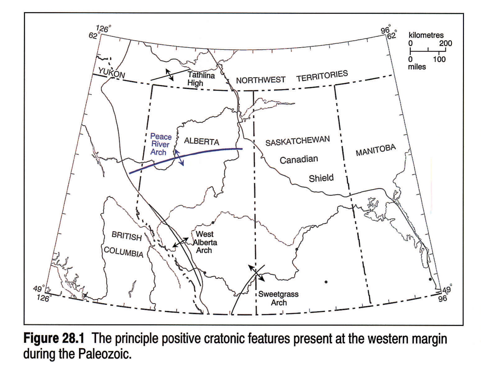
The PRA is one of four major positive cratonic features that developed at the western edge of the North American craton, bordering the lower Paleozoic passive margin (Fig. 28.1). The PRA is the largest of these structures, and has the longest recorded history of tectonic activity. The West Alberta Arch paralleled the passive margin and formed a southern continuation of the PRA landmass until its burial during the Late Devonian (Frasnian)(Moore, 1989). The Tathlina High, which is parallel to the PRA, formed an uplifted area in northwest Alberta and the District of Mackenzie from the Cambrian until its burial in the Middle Devonian (Givetian) (van Hees, 1964; Moore, 1989). In southern Alberta the Sweetgrass Arch (Lorenz, 1982; Podruski, 1988) and Montania (Norris and Price, 1966) formed smaller cratonic uplifts from the Late Proterozoic onward.
Configuration of the Arch
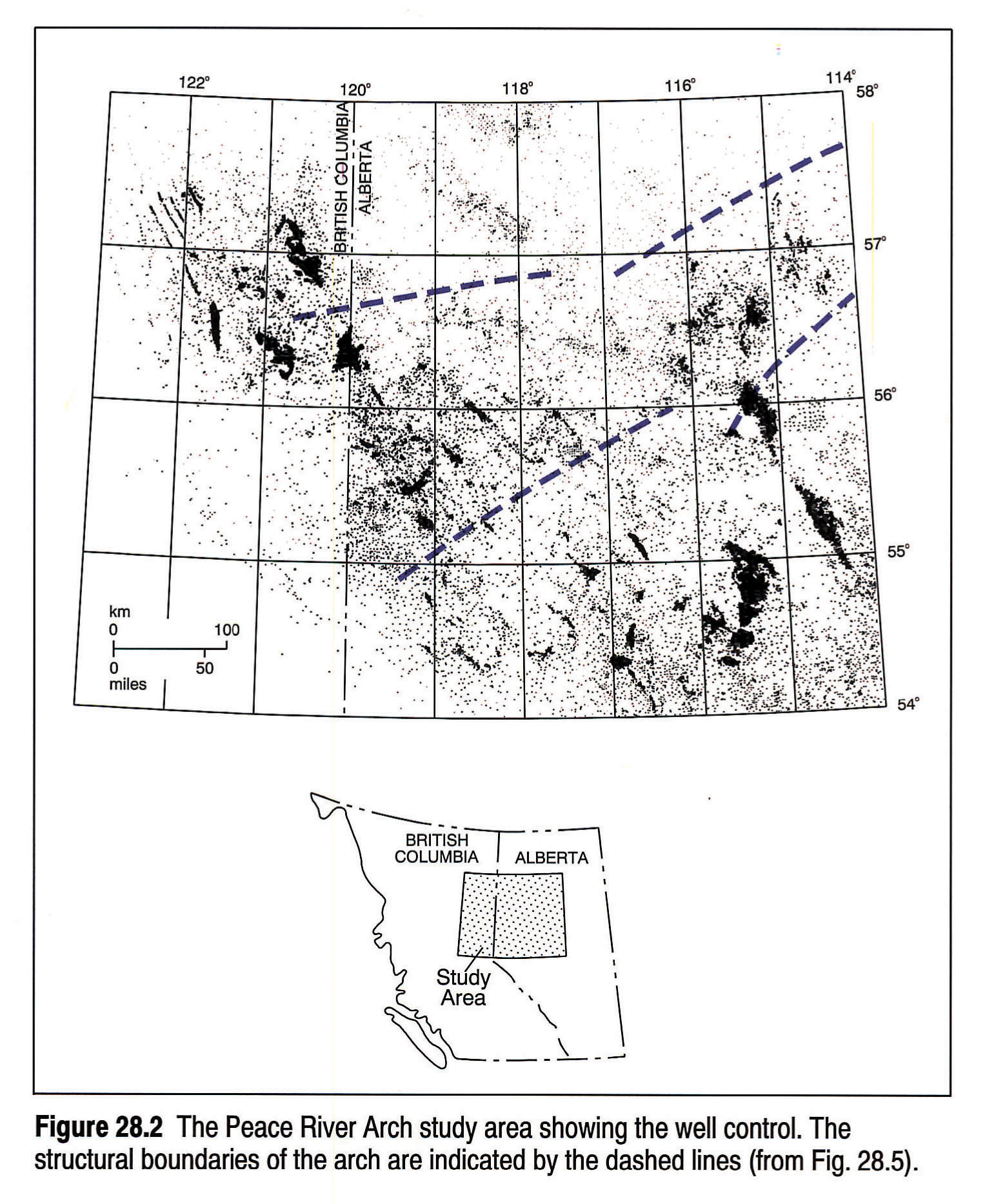
The PRA is an east-northeasterly trending structure that has a total preserved length of approximately 750 km (see Burwash et al., this volume, Chapter 5). At its western end, near the Alberta/British Columbia boundary, the arch stands approximately 1,000 m above the regional elevation of the basement (Cant, 1988). The amplitude of the arch decreases eastward to between 400 and 500 m at the fifth meridian and several tens of metres at its eastern end, near the fourth meridian. Most of the maps referred to in this synthesis are derived from O'Connell et al. (1990) and extend from 54 to 58° latitude and from the fifth meridian (114°) to either the British Columbia/Alberta boundary, or to the Cordilleran outcrop in British Columbia (Fig. 28.2).
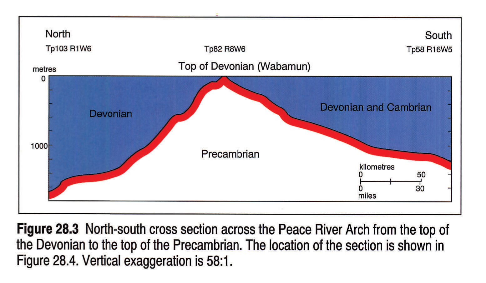
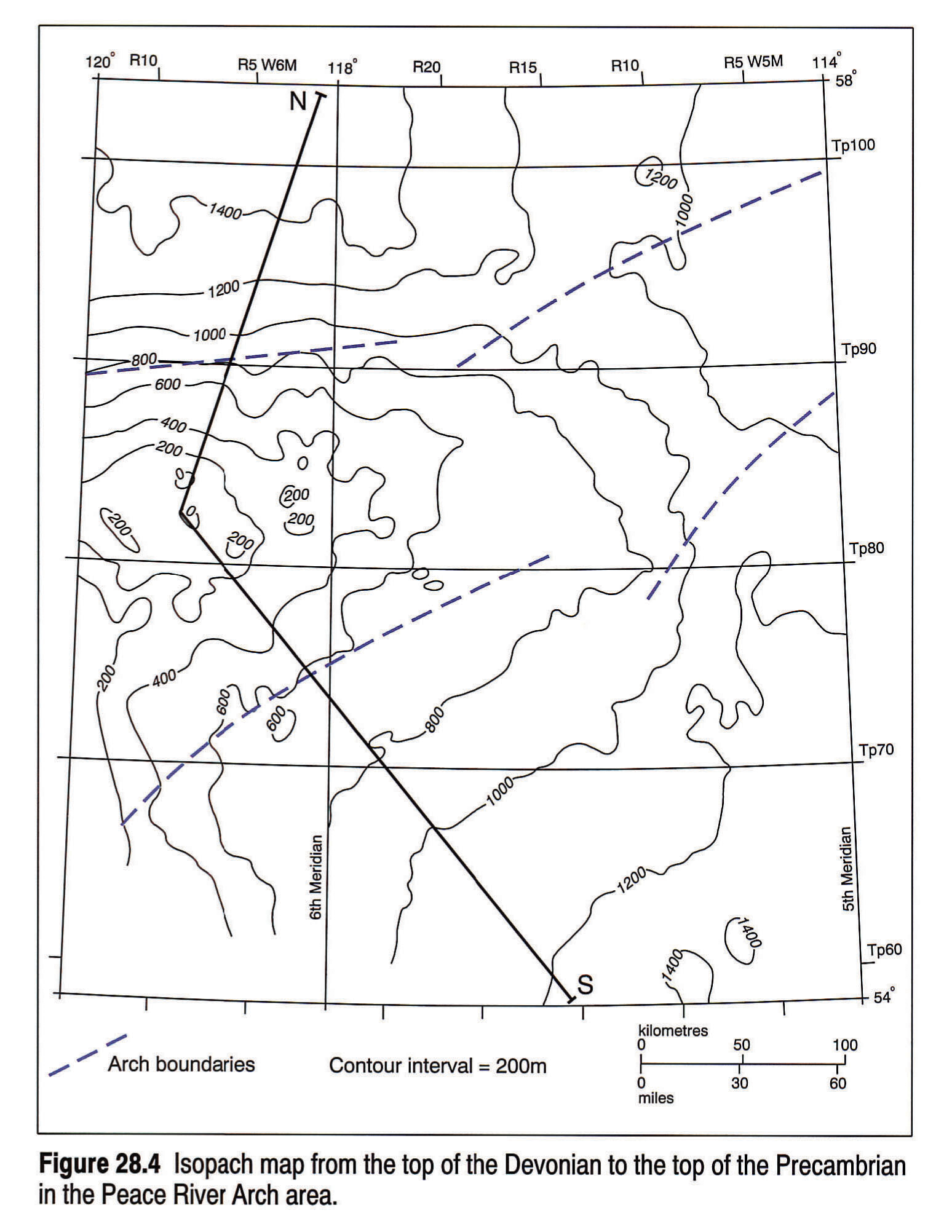
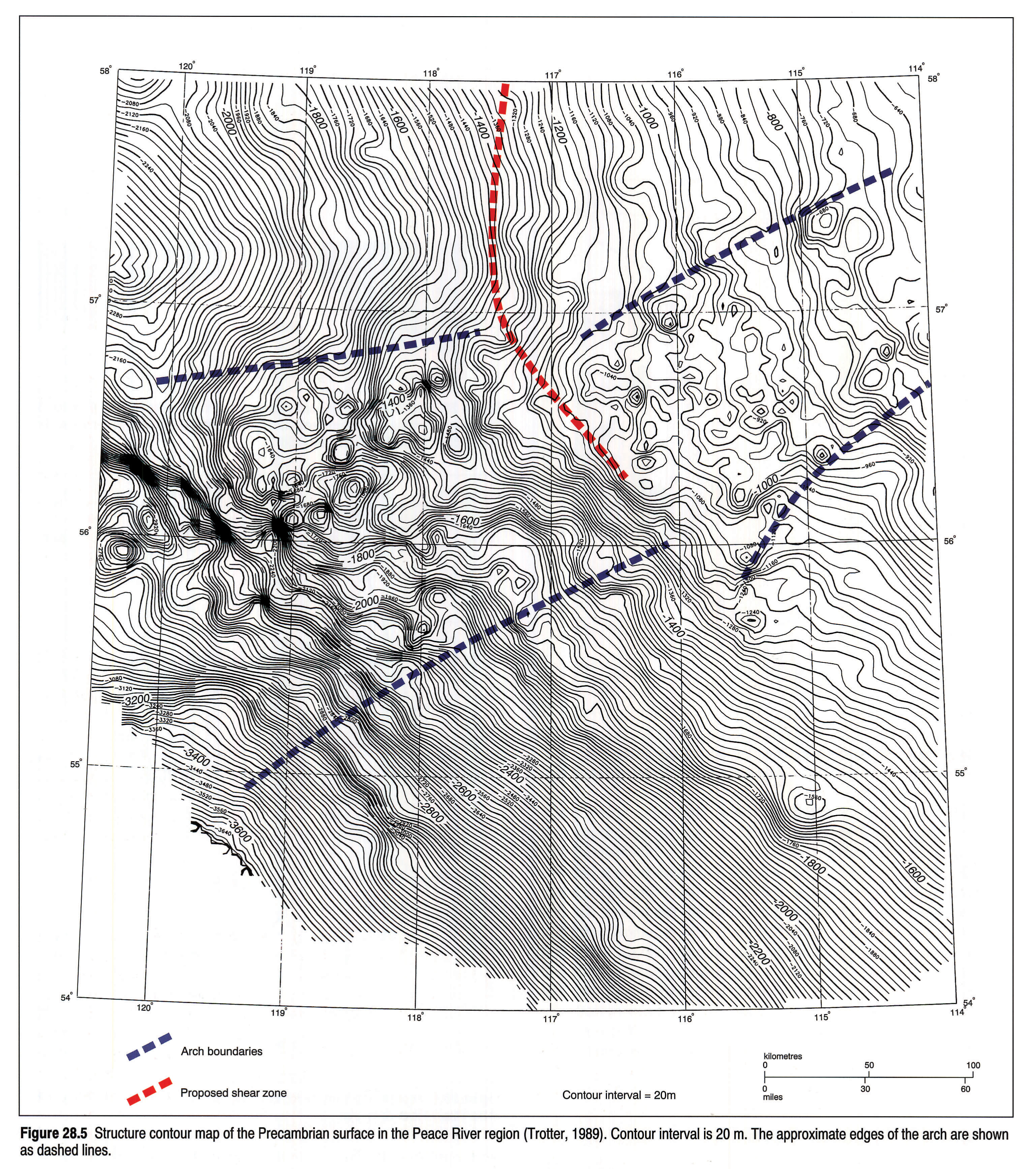
The PRA is an asymmetrical structure with a steeply dipping northern flank and a more gently dipping southern slope (Fig. 28.3; O'Connell et al., 1990; McMechan, 1990). An isopach from the top of the Devonian to the basement (Fig. 28.4) shows that total deposition immediately to the north of the arch was several hundred metres thicker than it was to the south. A structure contour map of the Precambrian surface (Fig. 28.5; Trotter, 1989) delineates the approximate structural boundaries of the arch. The zone of structural disturbance is approximately 140 km wide at the sixth meridian. O'Connell et al. (1990) proposed that the Arch is vertically offset along a north-south-trending line that may coincide with a basement shear zone (Fig. 28.5).
Descriptions of PRA structures are presented by DeMille (1958), Lavoie (1958), Williams (1958), Sikabonyi and Rodgers (1959), Jones (1980), Cant (1988), Barclay et al. (1990), Dix (1990), and O'Connell et al. (1990), who all use well log and sedimentological data to identify fault locations and trends, as well as magnitudes and types of offset. There are no published descriptions of regionally significant PRA structures or structural trends based on the interpretation of reflection seismic data, although seismic studies of some local features are publicly available (e.g., Anderson et al., 1989).
Peace River Arch History
Precambrian Basement
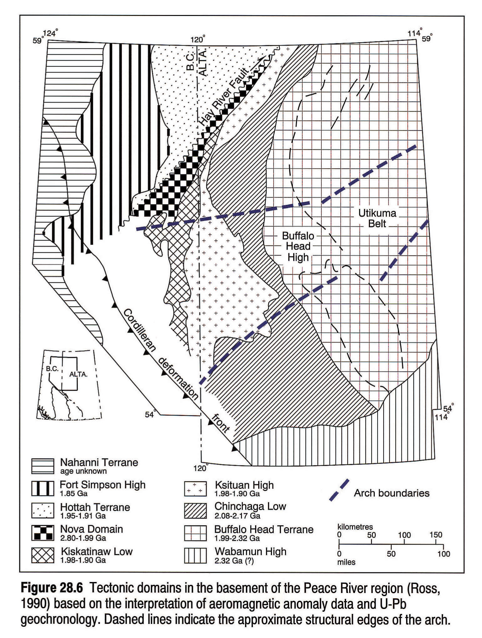
Ross (1990) divided the basement of northern Alberta into a series of Archean and Proterozoic tectonic domains, based on aeromagnetic and gravity anomaly data, and on radiometric ages. There are three distinct basement zones in the Peace River region: the Buffalo Head, the Chinchaga, and the Ksituan domains (Fig. 28.6). The subcrops of these domains can be traced by their aeromagnetic signatures, which have a north-trending curvilinear configuration. There do not appear to be any northeast-trending features in the Alberta basement that coincide with the location of the PRA, nor does the arch appear to coincide with any single Precambrian structural zone.
Burwash and Krupicka (1969, 1970) have defined a broad, northeast-trending zone of regional metasomatism, approximately 800 km wide, in central and northern Alberta, which they have labelled the Athabasca Mobile Zone. They suggest a genetic link between the PRA and this zone. However, there are no distinctive aeromagnetic or gravity anomalies that coincide with the axis of the PRA (Zelt, 1989; Stephenson et al., 1989; Ross, 1990). A seismic refraction survey in the Peace River region (Stephenson et al., 1989; Zelt, 1989) shows that there is a subtle velocity anomaly or crustal uplift at Moho level that is partly coincident with the axis of the PRA. However, this crustal feature is not reflected in the ancestral basement structure in the region, which implies that the PRA uplift was superimposed upon a pre-existing Precambrian basement geology.
Proterozoic to Lower Devonian
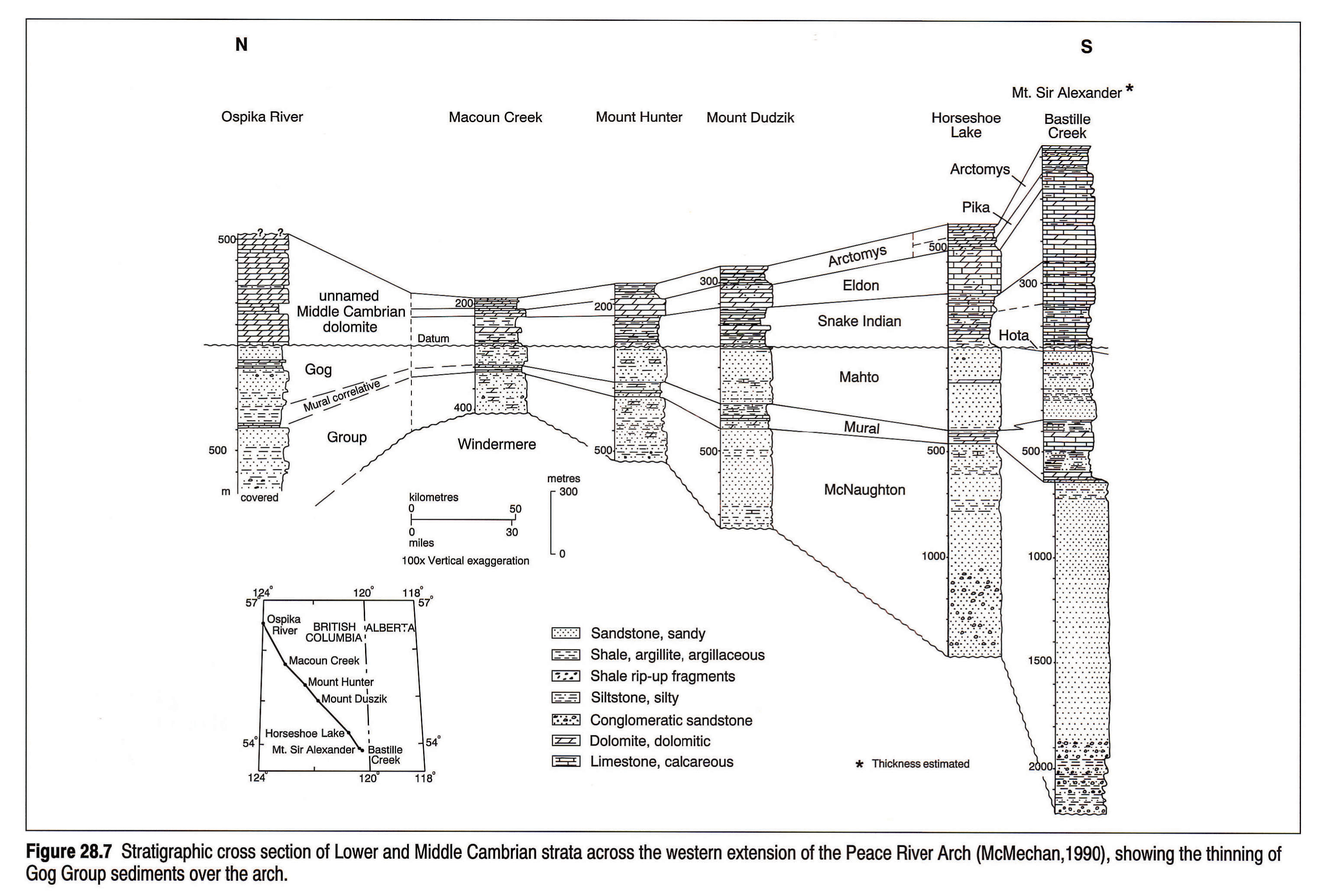
Pre-Middle Devonian rocks are largely absent in the vicinity of the PRA. Fortunately, information on the Proterozoic and early Paleozoic history of the arch can be obtained from exposures in the Rocky Mountains. Facies changes and thinning within the Upper Proterozoic strata of the Windermere Supergroup indicate that a pronounced embayment existed at the eastern edge of the area of Windermere deposition on trend with the southern edge of the present-day PRA (McMechan, 1990). The embayment may represent a proto-arch structure that later influenced the placement and evolution of the PRA. The first indication of a relatively uplifted arch structure is provided by the thinning of the Lower Cambrian Gog Group to the west of the present-day subsurface arch (Fig. 28.7). The Gog Group overlies uplifted and truncated sediments of the Upper Proterozoic Windermere Supergroup. The uplift was asymmetrical, with maximum differential subsidence to the north of the arch (McMechan, 1990).
The PRA formed the northern margin of the Middle Cambrian cratonic embayment in central Alberta (Aitken, 1989). An increase in the proportion of siliciclastics within the Middle Cambrian platform carbonates adjacent to the PRA (Pugh, 1973) indicates that it was a sediment source during that time. The Ordovician and Silurian deposits were stripped from virtually all of the PRA region and most of the surrounding craton by erosion prior to the Devonian, and thus there is no direct evidence of Arch configuration during this time. During the Ordovician and Silurian, detrital material, consisting mainly of quartz sand, was derived from the emergent PRA landmass and is preserved predominantly to the west and northwest (Norford, 1990).
Devonian
Granite Wash
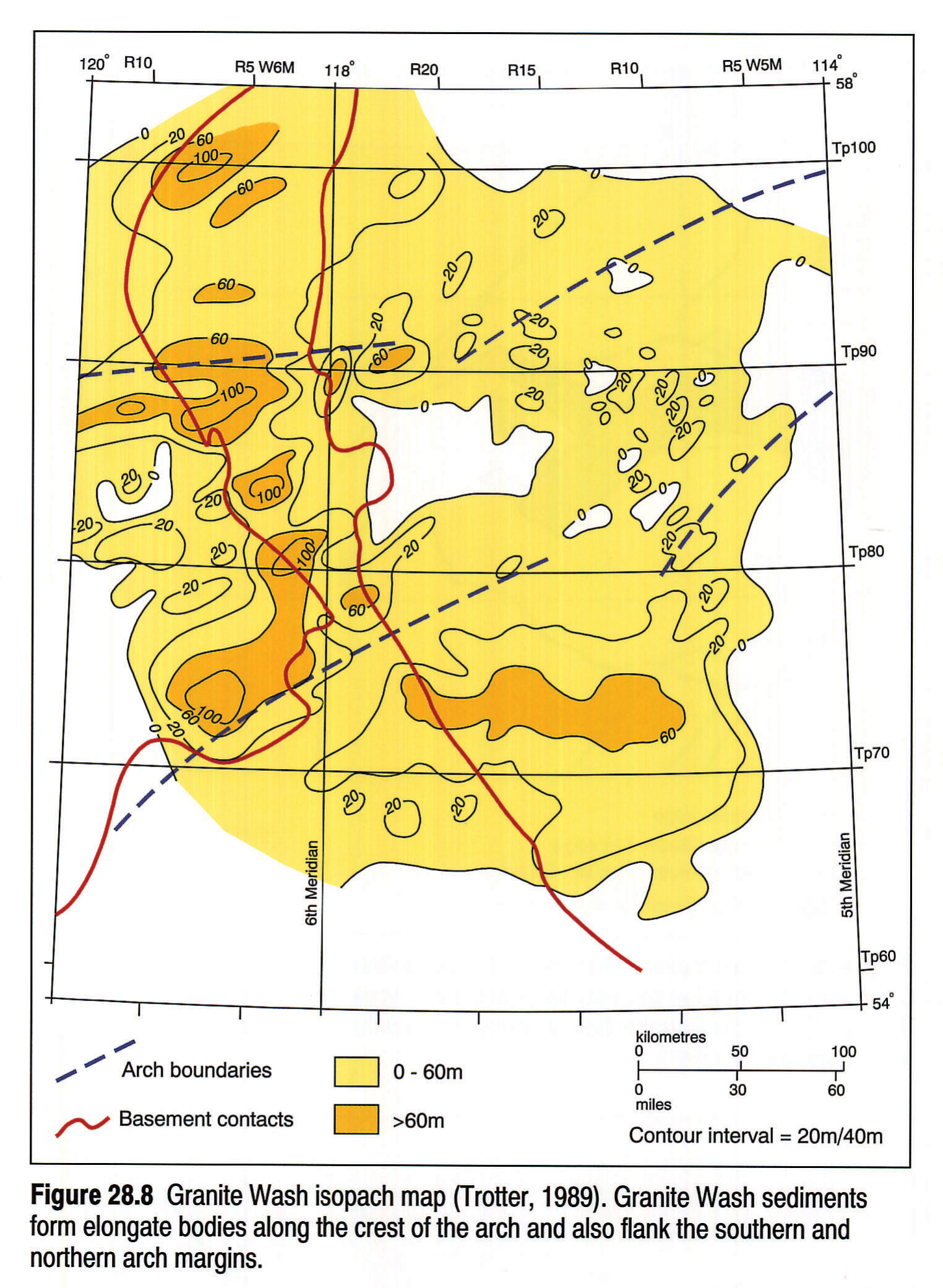
The Granite Wash is a diachronous, siliciclastic, lithostratigraphic unit that overlies the arch and also interfingers, in an off-arch direction, with Middle and Upper Devonian carbonate, shale and evaporite units. The unit consists of material derived from erosion of the predominantly granitic and metasedimentary rocks of the uplifted basement, which forms the axis of the arch. The eroded material has filled in many low areas on the crest and flanks of the arch, and an isopach map of the Granite Wash provides an excellent indication of the early structural configuration of the uplift as well as its constituent km-scale horsts and grabens (Fig. 28.8).
Over the crest of the arch, the Granite Wash is up to 100 m thick and is confined within fault-bounded grabens that have a predominantly east-west alignment. These grabens are interpreted as extensional responses to the uplift of the arch (Cant, 1988). In contrast, to the north and south of the arch, the Granite Wash forms more widespread sandstone units. These were deposited in fluvial, shoreline and shallow-marine complexes that flanked the arch at various times during Middle and Late Devonian time (Trotter and Hein, 1988). Toward the eastern end of the arch, the Granite Wash forms narrow northeast- to north-northeast-trending sand bodies deposited in fluvial, estuarine, and shallow-marine settings. The lower parts of these units infill grabens or half grabens formed during episodes of extension related to arch uplift (Anderson et al., 1989; Trotter, 1989). The ages of Granite Wash sediments are unknown except where they interfinger with Middle and Upper Devonian carbonate strata. The Granite Wash that underlies the Middle Devonian and fills the grabens along the arch crest is undated.
Elk Point Group
Evaporites, carbonates, and clastics of the Middle Devonian Elk Point Group comprise the initial sediments that onlapped much of the PRA. These rocks were deposited within a shallow, restricted, epicontinental seaway that was separated from the open ocean to the northwest and west by the PRA and the West Alberta Arch. The Elk Point Group, which is up to 1000 m thick in the deepest parts of the basin, progressively onlaps the arch and is absent through nondeposition over the crests of both the arch and the West Alberta Ridge (see Meijer Drees, this volume, Chapter 10).
Most of the units in the Elk Point Group have a clastic inshore facies equivalent on the flanks of the basin, or contain coarse siliciclastic interbeds derived from the arch. Within the Lower Elk Point Group, for example, the dolomite and dolomitic shales of the Contact Rapids Formation pass laterally into thick units of Granite Wash clastics on the northern and southern flanks of the PRA, implying that they are partly time-equivalent (Meijer Drees, 1986). The shelf carbonates of the Upper Elk Point Keg River Formation are commonly interbedded with shales and sandstones of the Granite Wash (Burrowes and Krause, 1987; Campbell, 1987). A major regressive episode, possibly associated with regional uplift of the PRA and West Alberta Ridge, gave rise to the shales of the Watt Mountain Formation and the Gilwood Sandstone Member, which flank the PRA (Meijer Drees et al., in press).
Beaverhill Lake Group
At the beginning of Beaverhill Lake deposition (Fig. 28.9), while the Fort Vermilion evaporites and Slave Point platform carbonates were being laid down, the arch was a relatively stable feature (Keith, 1990). Carbonate buildups, equivalent to the reefs of the Swan Hills Formation of central Alberta (Fischbuch, 1968), form patch and fringing reefs within an arcuate trend around the eastern margin of the landmass (Podruski et al., 1988; Moore 1989; Gosselin et al., 1989). These carbonate buildups appear to be strongly influenced by pre-depositional topographic relief of the underlying Precambrian. Episodic movement along fault-bounded Precambrian highs may have influenced sedimentation patterns within and around the reefs (Gosselin et al., 1989).
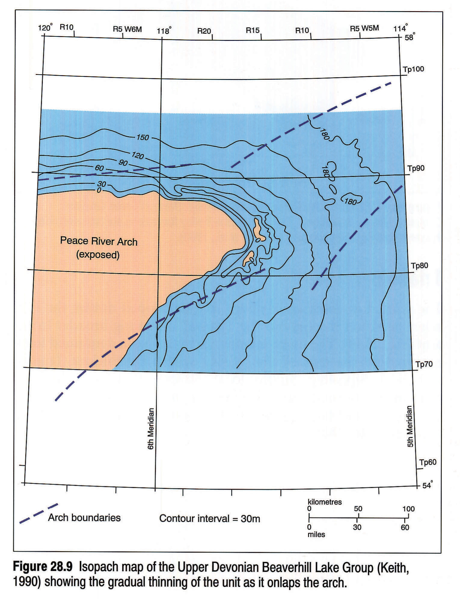
At the end of Slave Point deposition, a period of instability commenced and there was a marked increase in the rate of differential subsidence of the basin some distance away from the PRA (Keith, 1990). Both the carbonate platform and the reefs are sharply overlain by the predominantly basinal strata of the Waterways Formation, which onlap the arch from the east, with many units demonstrating a well-developed west-facing clinoform geometry (Stoakes, 1988; Keith, 1990). Upper Waterways units are more uniform in thickness but also thin toward the arch and onlap it.
Woodbend Group
At the base of the Woodbend Group in central Alberta, the Cooking Lake Formation consists of widespread and fairly uniform carbonate platform deposits. The platform facies is succeeded by the argillaceous carbonates and basinal shales of the Ireton and Fort Simpson formations, and the intrabasinal carbonate platforms of the Leduc Formation. The Leduc Formation consists of a basinward-thickening dolomite lithosome that onlaps the Beaverhill Lake Group, the Granite Wash, and the Precambrian basement, to form a carbonate aureole around part of the PRA (Fig. 28.10; Dix, 1990). Along the northern edge of the PRA the Leduc platform is relatively narrow and has an approximate east-west orientation. The Leduc platform widens to the east, and displays a northeast-southwest trend as it wraps around the southern margin of the arch. The increase in platform width to the south is believed to have resulted from the gentler dip of the Precambrian surface along the southern slope of the arch.
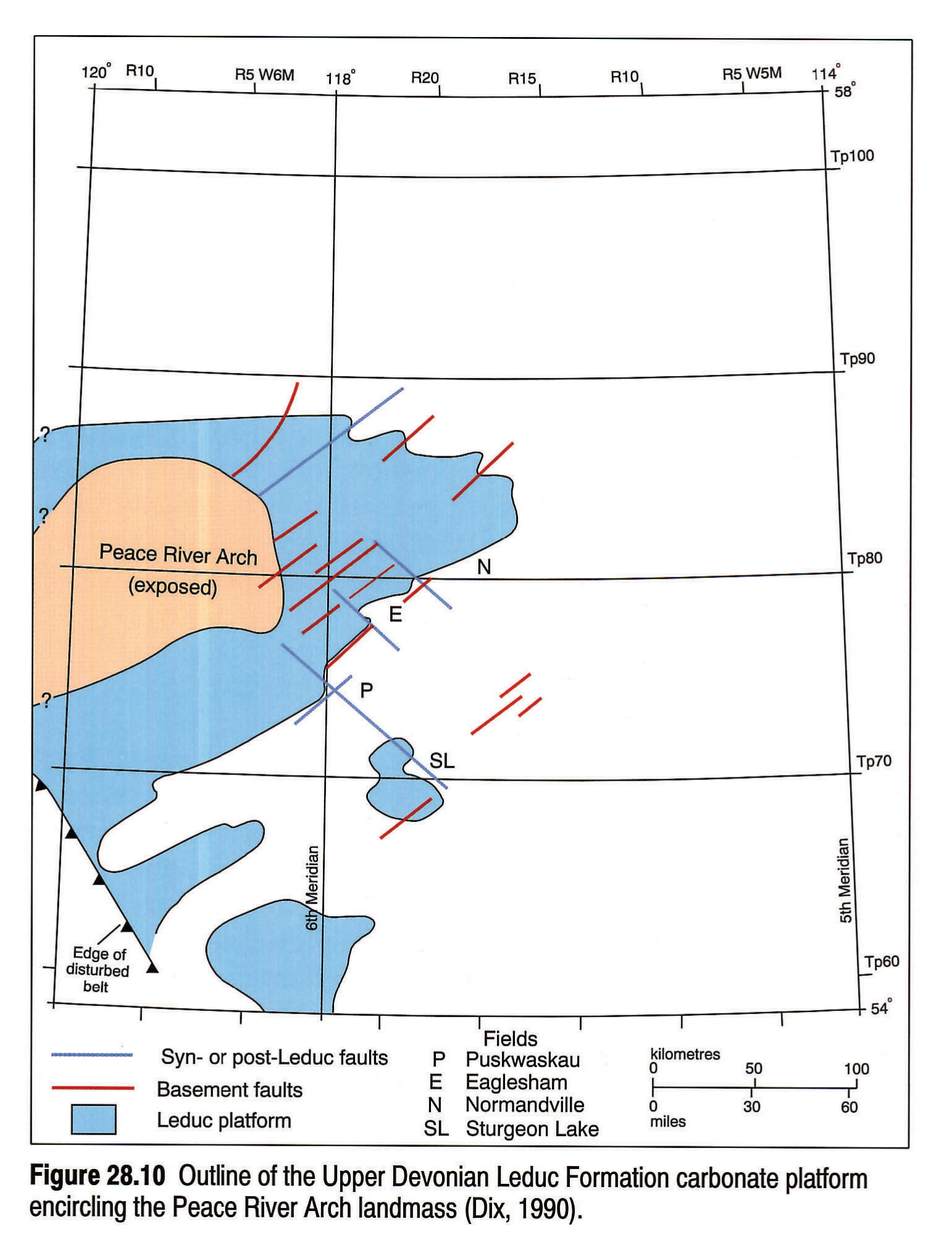
Evidence for arch-related syndepositional structural disruption of the Leduc Formation is provided by numerous examples of thickness variations and changes in carbonate and siliciclastic facies distribution (Dix, 1990). Many of these variations and changes can be spatially related to underlying Precambrian lineaments, which appear to have been tectonically active. Dix (1990) suggested that there was a regional differential tilting of the PRA during late Leduc deposition resulting in erosion and the progradation of Granite Wash siliciclastics. Changes in regional sediment sources during late Leduc deposition also indicate possible modification of the basin away from the PRA (Geldsetzer, 1988; Dix, 1990).
Winterburn and Wabamun
The gradual decrease in the area of the exposed PRA basement continued throughout the remainder of the Devonian. The Winterburn Group consists of offlapping carbonate platforms (the Nisku and Blueridge formations) each with a gradual transition into basinal sediments (Moore, 1988). During Winterburn deposition, pre-existing topography on the PRA was bevelled and the landmass area decreased. The Wabamun Formation forms a widespread, generally uniform, micrite-dominated carbonate ramp that thins across the crest of the PRA, indicating near-complete inundation of the PRA landmass (Halbertsma and Meijer Drees, 1987).
Carboniferous
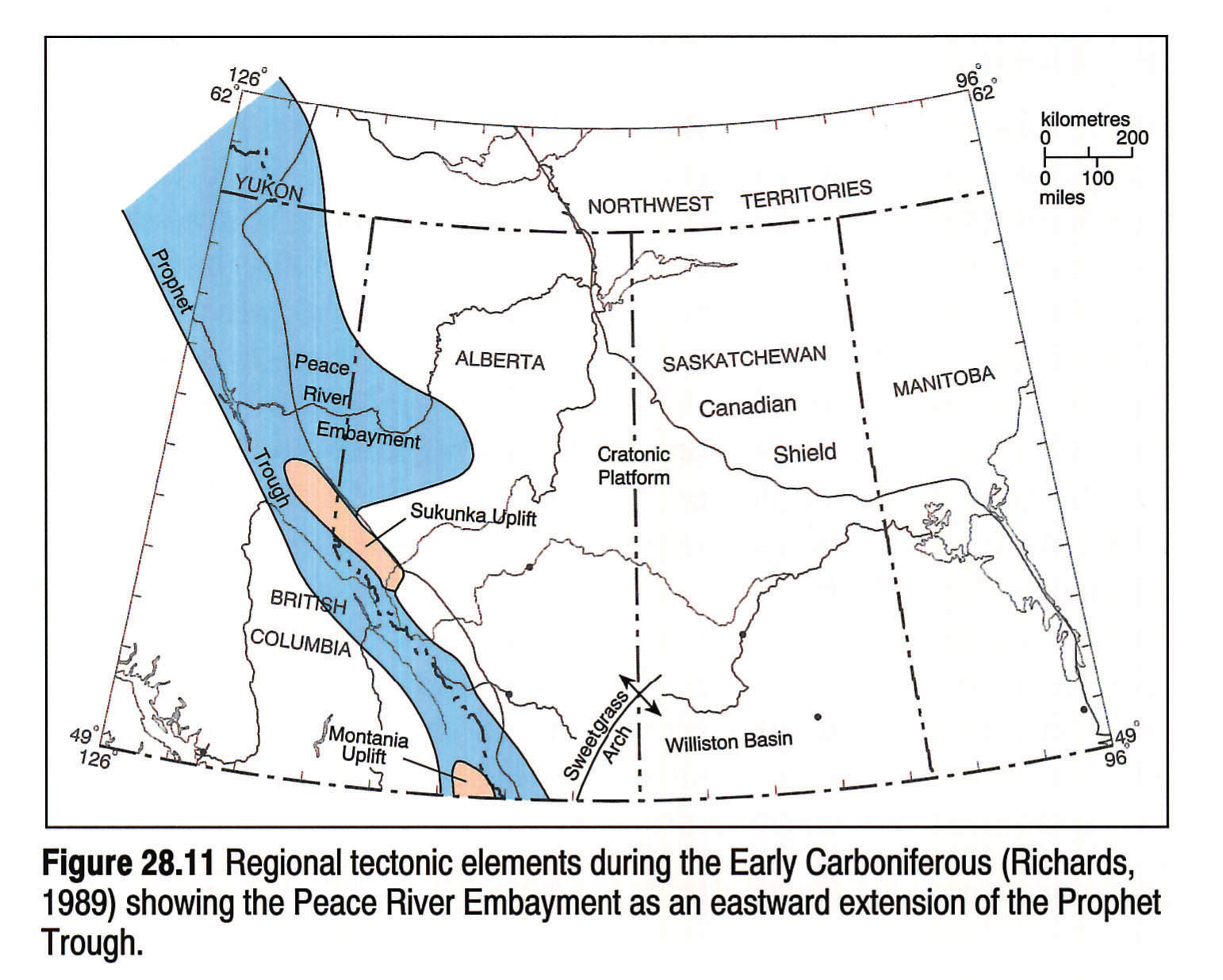
By the beginning of the Carboniferous, the PRA was no longer emergent and marine shelf conditions extended throughout the Western Canada cratonic platform. An arcuate zone of enhanced subsidence, known as the Peace River Embayment (PRE) (Douglas, 1970), was established in the Peace River area (Fig. 28.11). The PRE opened to the west and formed an eastward extension of the Prophet Trough, a narrow pericratonic trough that extended from southern British Columbia to the Yukon (Richards, 1989). The Carboniferous succession in the PRE is divided into three main stratigraphic units: the lower to middle Tournaisian Banff Formation, the middle Tournaisian to upper Viséan Rundle Group, and the upper Viséan to Serpukhovian Stoddart Group. During deposition of the the Banff Formation and the lower part of the Rundle Group (the Pekisko Formation) the maximum subsidence within the PRE was developed to the north of the crest of the Devonian arch, and reflects a continuation of Devonian subsidence trends (Lavoie, 1958; O'Connell, 1990). The upper part of the Rundle Group and the Stoddart Group were deposited in a basin, whose axis overlies the central region of the PRA, representing a tectonic inversion of the uplift that formed the arch.
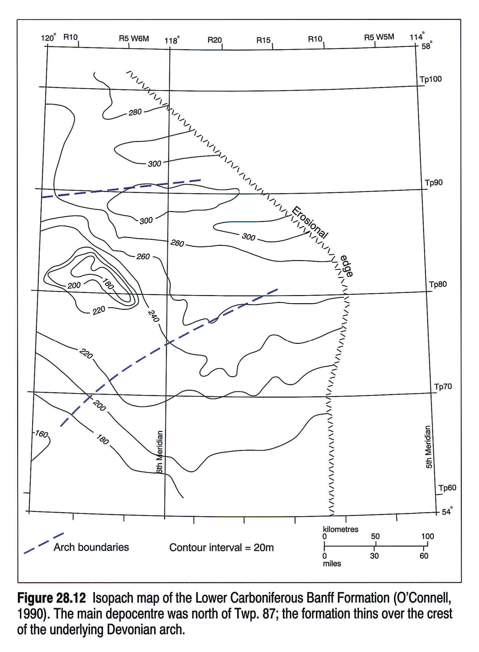
Banff Formation
The Banff Formation consists of a progradational, shallowing-upward succession of argillaceous shales, carbonates, and siliciclastics (Bamber et al., 1980; Chatellier, 1988). The Banff Formation thins to less than 180 m over the crest of the Devonian arch, between Twps. 79 and 83 W6M (Fig. 28.12). The thickest accumulation of Banff Formation sediments within the PRE (over 300 m) is to the north of the axis of the Devonian arch between Twps. 86 and 96 (Fig. 28.12). This thickening consists mainly of basinal shales and carbonate ramp deposits that formed during lower Banff deposition and outline the central axis of the PRE (O'Connell, 1990). By the end of lower Banff deposition, differential subsidence throughout the Peace River area appears to have ceased and shallower water, middle and upper Banff units prograded across the area with little variation in overall sediment thickness (O'Connell, 1990).
Rundle Group
The Rundle Group forms a progradational shallowing-upward succession in which deep-water carbonates and shales pass upward into restricted shelf carbonates, siliciclastics and evaporites. Renewed subsidence prior to and during the deposition of the Pekisko Formation (at the base of the Rundle Group) gave rise to a second phase of the PRE. This was a semi-enclosed, east-west-trending embayment, the axis of which is centered along Twp. 86, to the north of the crest of the underlying Devonian arch (Fig. 28.13), as outlined by an upper Pekisko shale member (O'Connell, 1990). The Pekisko Formation represents the final phase of basinal deposition in the area north of the Devonian arch. Subsequent to Pekisko deposition maximum differential subsidence occurred to the south, directly overlying the crest of the arch.
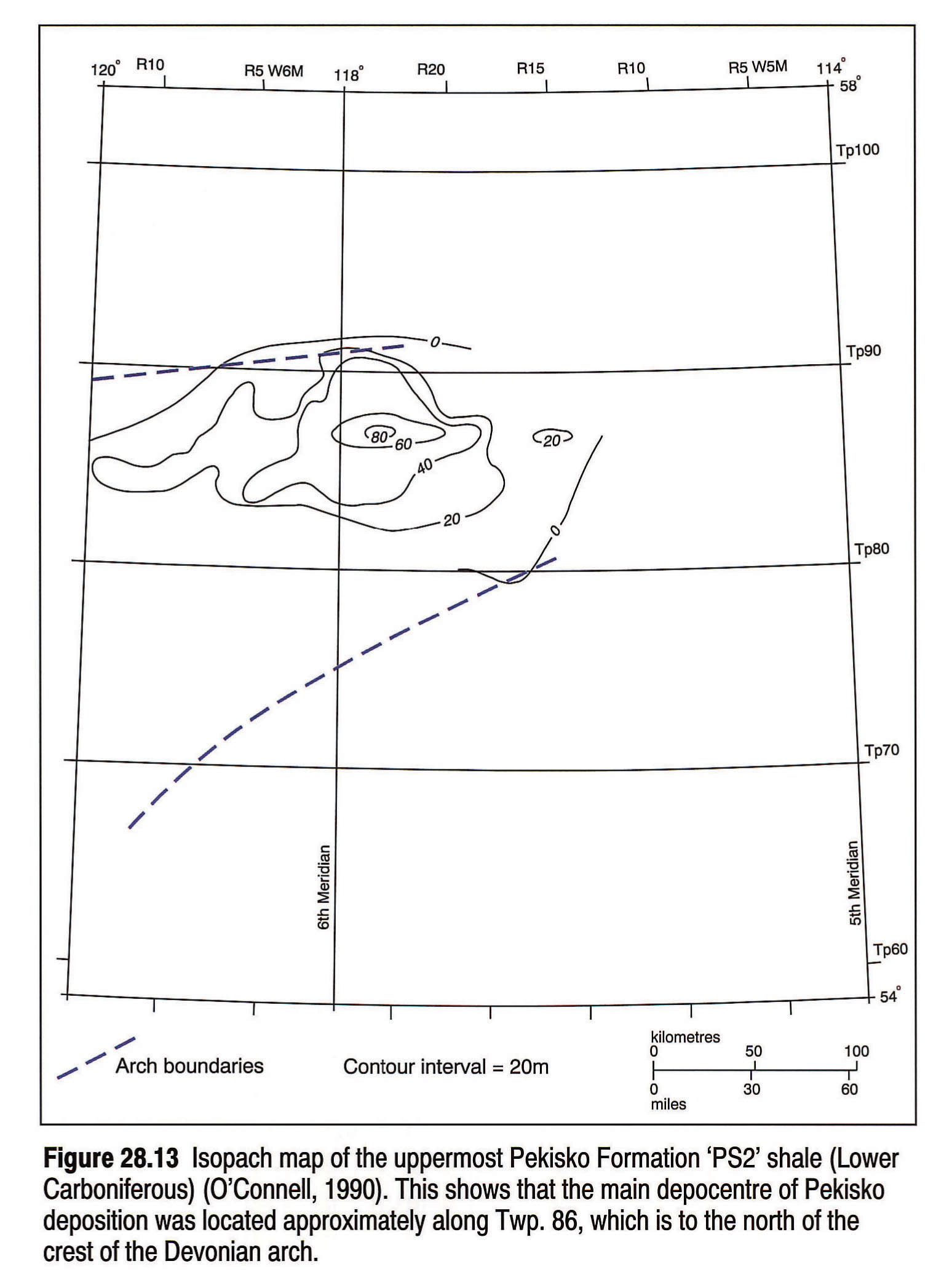
Subsidence patterns at the western edge of the PRE, in British Columbia, indicate that the main structural elements that later dominated during Stoddart and Belloy deposition were initiated during deposition of the Banff Formation (Macauley et al., 1964; Barclay et al., 1990). Local syndepositional thickening and thinning of the Banff and Pekisko formations is present in the area overlying the central region of the PRA, indicating that the arch-related structures were active during deposition (O'Connell, 1990). Barclay et al. (1990) demonstrated that the main graben structures that controlled Stoddart deposition were developing as the Debolt Formation was accumulating (see also Macauley et al., 1964).
Stoddart Group
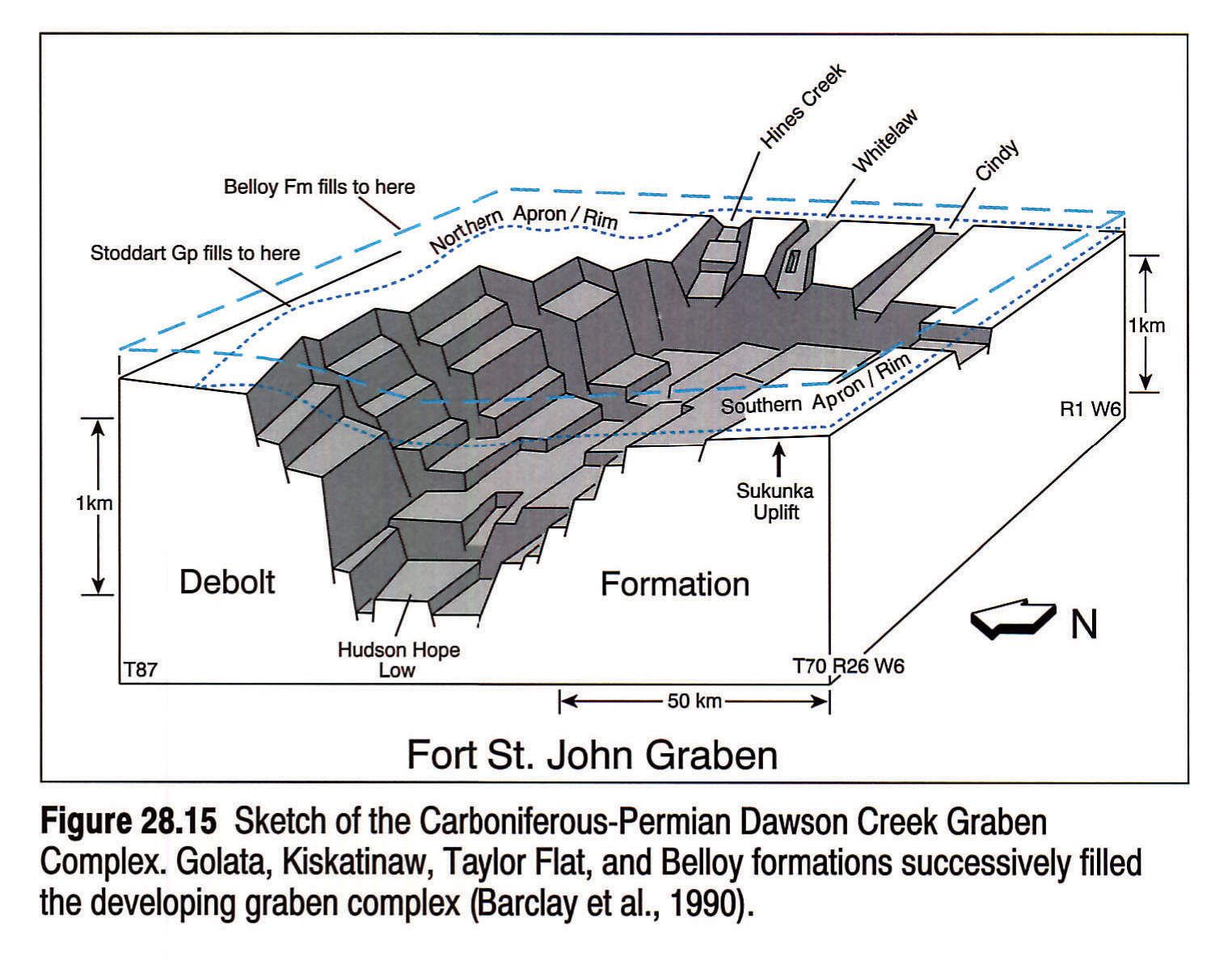
From the lower Viséan onward, the PRA uplift was fundamentally transformed by the development of a series of linked grabens that formed the central core of a renewed PRE. These grabens, collectively termed the Dawson Creek Graben Complex (DCGC) by Barclay et al. (1990), controlled deposition of the Stoddart Group and the Permian Belloy Formation. The DCGC comprises three main tectonic elements (Figs. 28.14, 28.15):
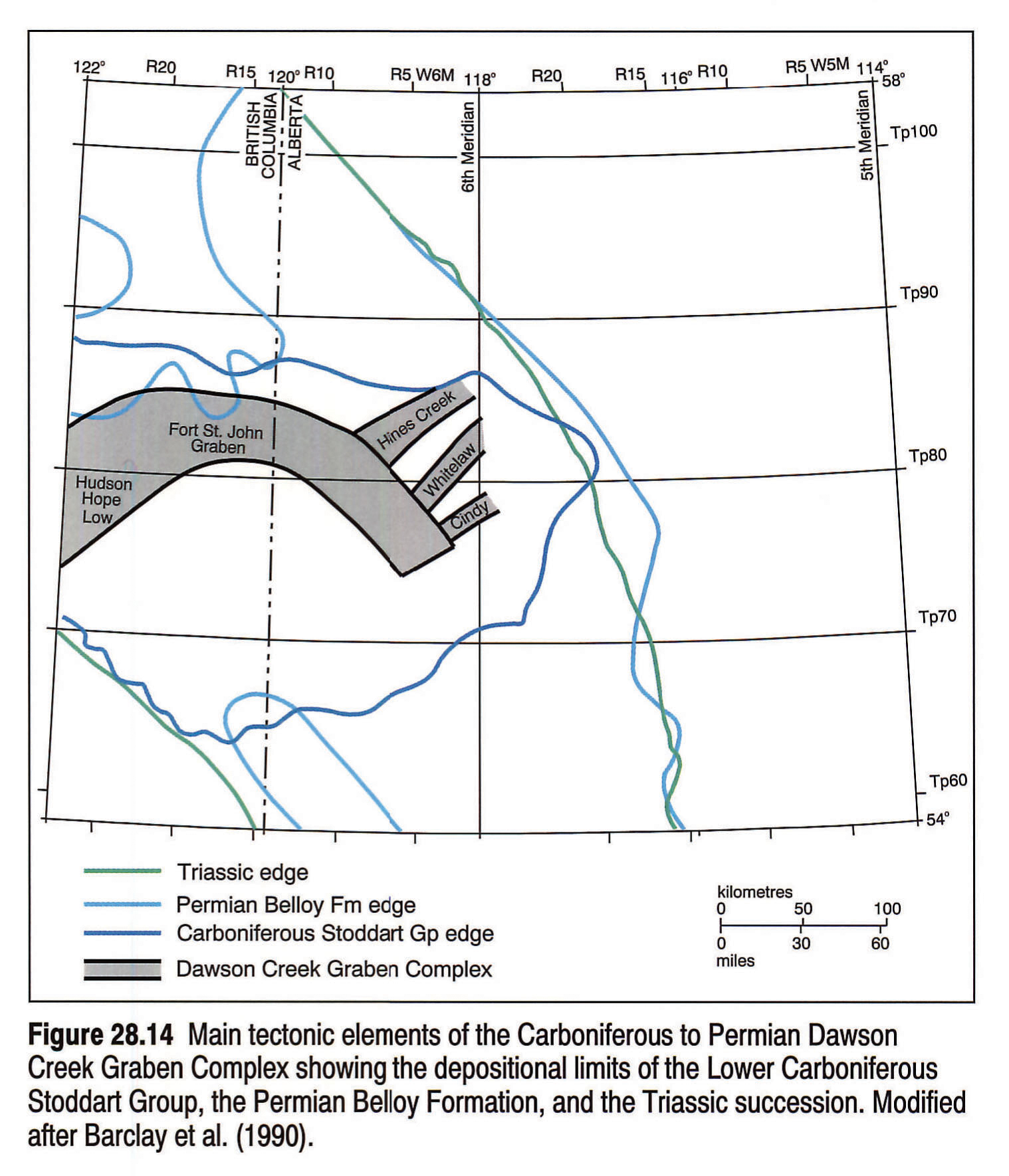
- The Fort St. John Graben (FSJG) is the main graben in the complex. It is an asymmetrical structure with a steep northern rim and a broad, gently sloping southern rim. The graben, which is intensely segmented and block faulted, has an easterly trend with a southeastern offset at its eastern end.
- At the western end of the FSJG is a prominent structural low termed the Hudson Hope Low (HHL). This is the earliest formed and the longest-lived feature of the complex.
- At the eastern end of the FSJG there are three smaller, northeast-trending satellite grabens: the Hines Creek, the Whitelaw, and the Cindy.
The Stoddart Group, consisting of the Golata, Kiskatinaw, and Taylor Flat formations, successively infilled the graben complex as it developed. The Stoddart Group in the HHL has a maximum thickness of 800 m, and a maximum thickness of 400 m at the eastern end of the FSJG (Fig. 28.16). The structural development of the DCGC is revealed by thickness patterns of Stoddart sediments, reflecting subsidence trends. Syndepositional control on the thickness of the formations occurred because of the continuous differential subsidence of horst and graben blocks. Major, basinwide inter- and intraformational unconformities are present, resulting from episodic structural uplift (Barclay et al., 1990). The Golata and Kiskatinaw formations mark a change in sedimentation style from the carbonates of the Rundle Group succession to siliciclastic sediments, and the latter are believed to have been derived from an eastern cratonic source.
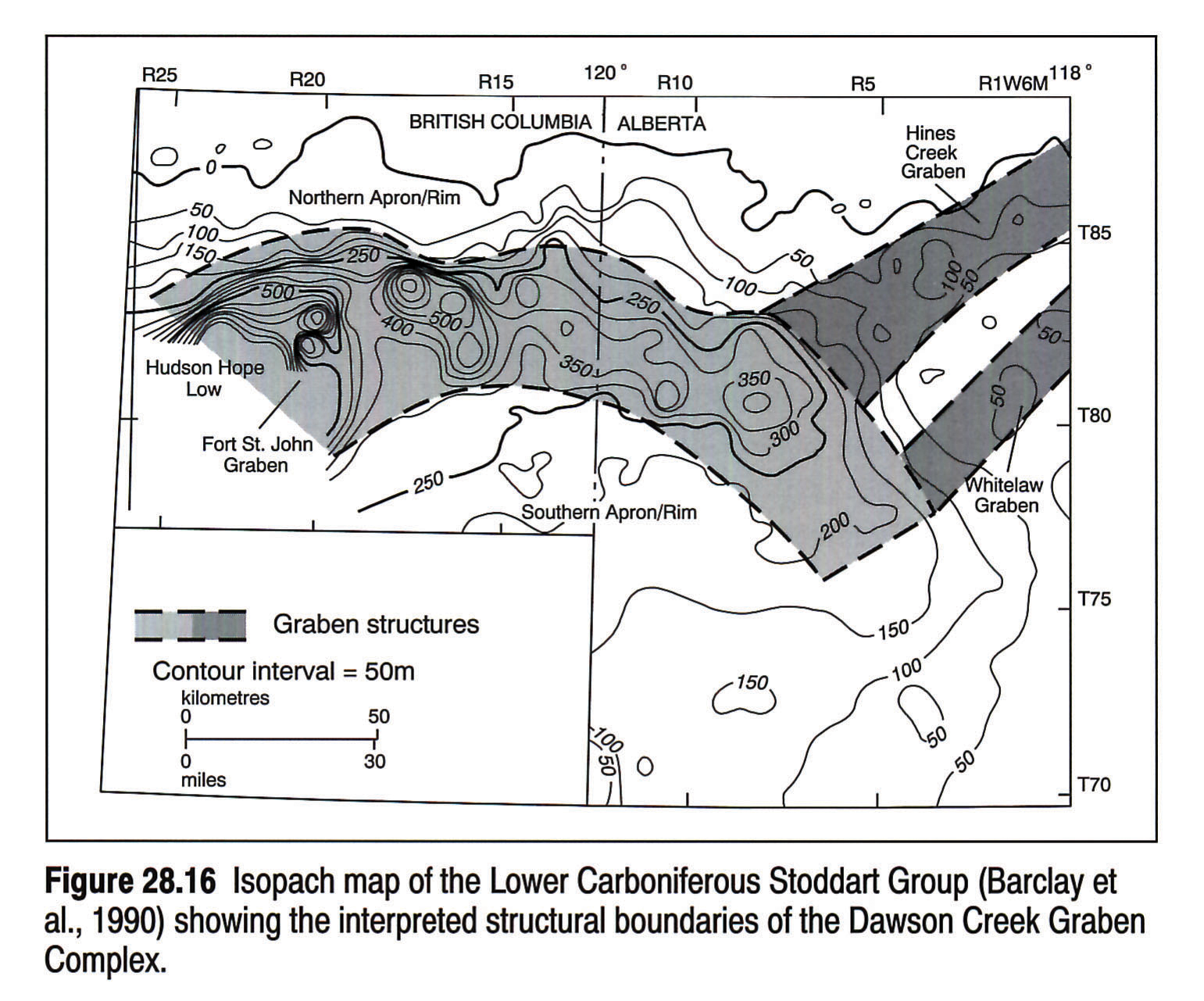
Permian
The PRE during the Permian was much broader and more tectonically stable than during Stoddart deposition (Fig. 28.14). Thickness variations within the mixed carbonate-siliciclastic sediments of the Belloy Formation show less local variability than the Stoddart, and the formation is not confined by the grabens. There was no significant subsidence of the main body of the FSJG during Belloy deposition, and local subsidence, with corresponding thickening of Belloy, is confined mainly to the deepest western end of the structure, in the HHL (Barclay et al., 1990).
Triassic
The wide, low-relief embayment that developed during the Permian persisted throughout the Triassic, becoming broader in extent (Fig. 28.14). The main subsidence in the basin continued to be centered on the axis of the DCGC, where the thickest Triassic section is deposited. Subtle, local movement along underlying Carboniferous horst and graben blocks caused variations in Triassic isopach and facies trends (Gibson and Barclay, 1989; Gibson and Edwards, 1990).
Jurassic
The Jurassic succession in the Peace River region includes both pre-orogenic and orogenic sediments. During the Early Jurassic pre-orogenic phase, subsidence of underlying DCGC structures within the PRE may have been responsible for minor thickness anomalies and the lateral variation of depositional environments within the basin (Poulton et al., 1990). Lower to Upper Jurassic pre-orogenic and orogenic Fernie Group sediments are noticeably thicker where they overlie the central PRA structure (Fig. 28.17). The sandstone-dominated, orogenically derived sediments of the Nikanassin/Minnes Group also thicken over the central Peace River region (Poulton et al., 1990).
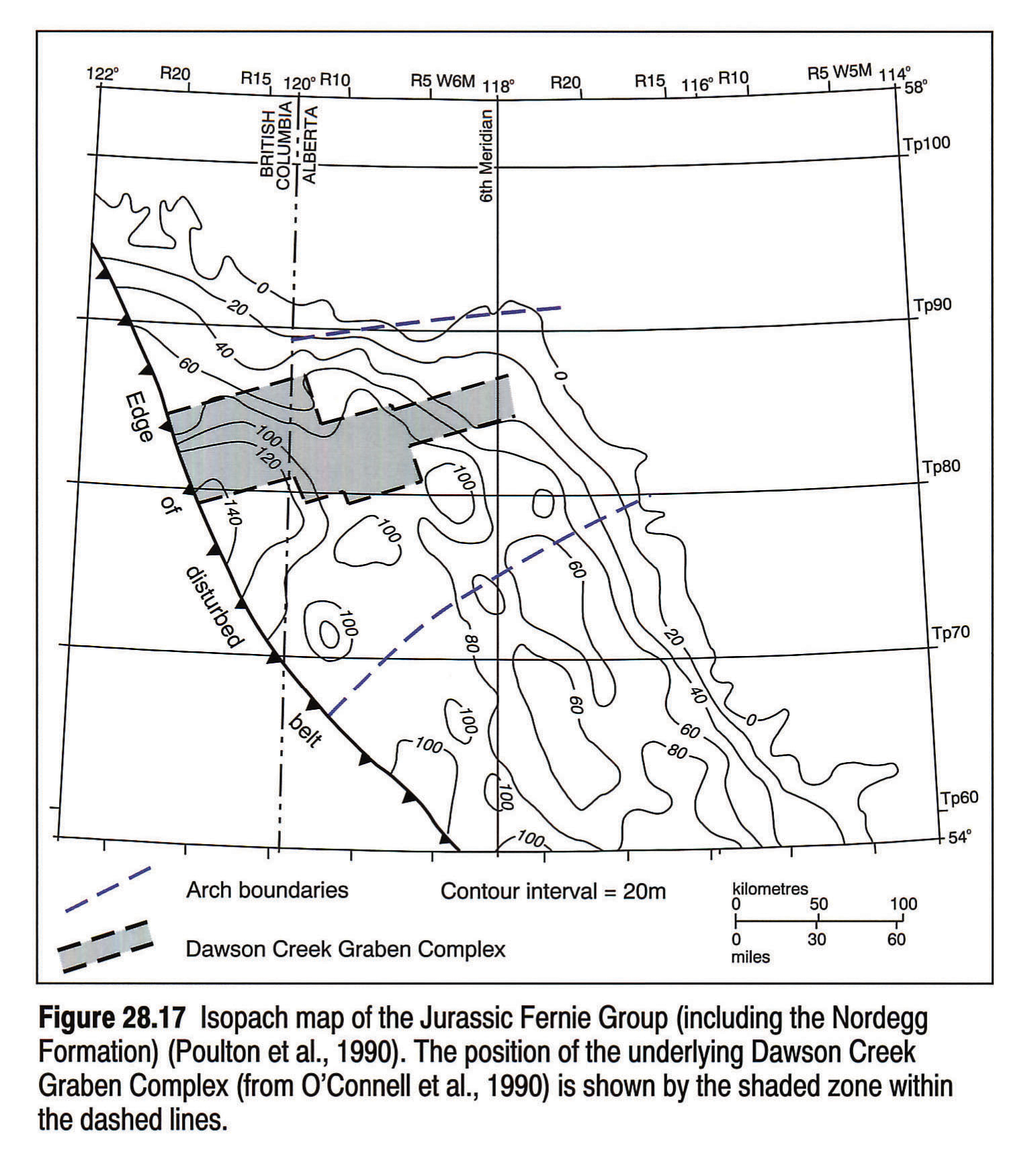
Cretaceous
From earliest Cretaceous time, accentuated subsidence occurred in the Peace River region, indicating an underlying local structural control of basin configuration in this area (Williams, 1958). Most of the evidence for this control has been described from the Lower Cretaceous Mannville Group and Peace River Formation. An anomalous northeast-trending thickening of the Lower Mannville Gething Formation overlies, and is parallel to, the DCGC (Stott, 1973; Smith et al., 1984; Gibson, 1992). This thickening may indicate that some fluvial channel trends within the Gething Formation were influenced by renewed subsidence of underlying graben structures. A large northeast-trending sand body within the Bluesky Formation (at the top of the Lower Mannville) that consists of lowstand shoreline and fluvial valley-fill sediments, is contained within the structural boundaries of the DCGC (Fig. 28.18). This suggests that renewed subsidence of the Carboniferous graben structures influenced the preferential preservation of this sand unit (O'Connell et al., 1990; O'Connell, 1992).
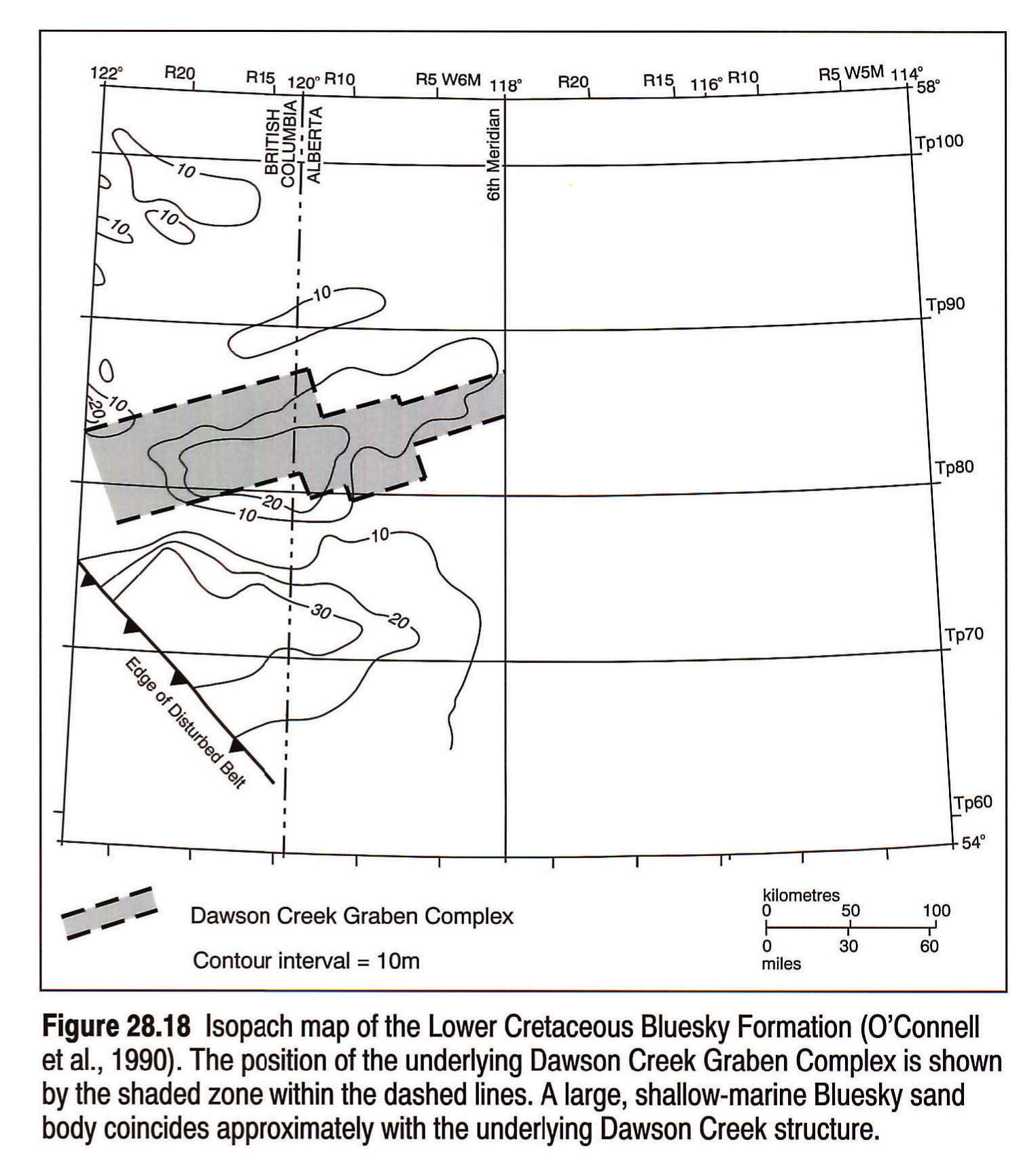
During Upper Mannville deposition an area of enhanced subsidence developed in the Peace River region. The axis of this basin parallels the trend of the DCGC and overlies its southern margin (Fig. 28.19). A series of Upper Mannville shoreline units are stacked on top of one another at the southern edge of the basin (Cant, 1984; Smith et al., 1984), and rapid subsidence of PRA/DCGC structures may have constrained the northward progradation of these shorelines (Leckie, 1986; Cant, 1984, 1988).
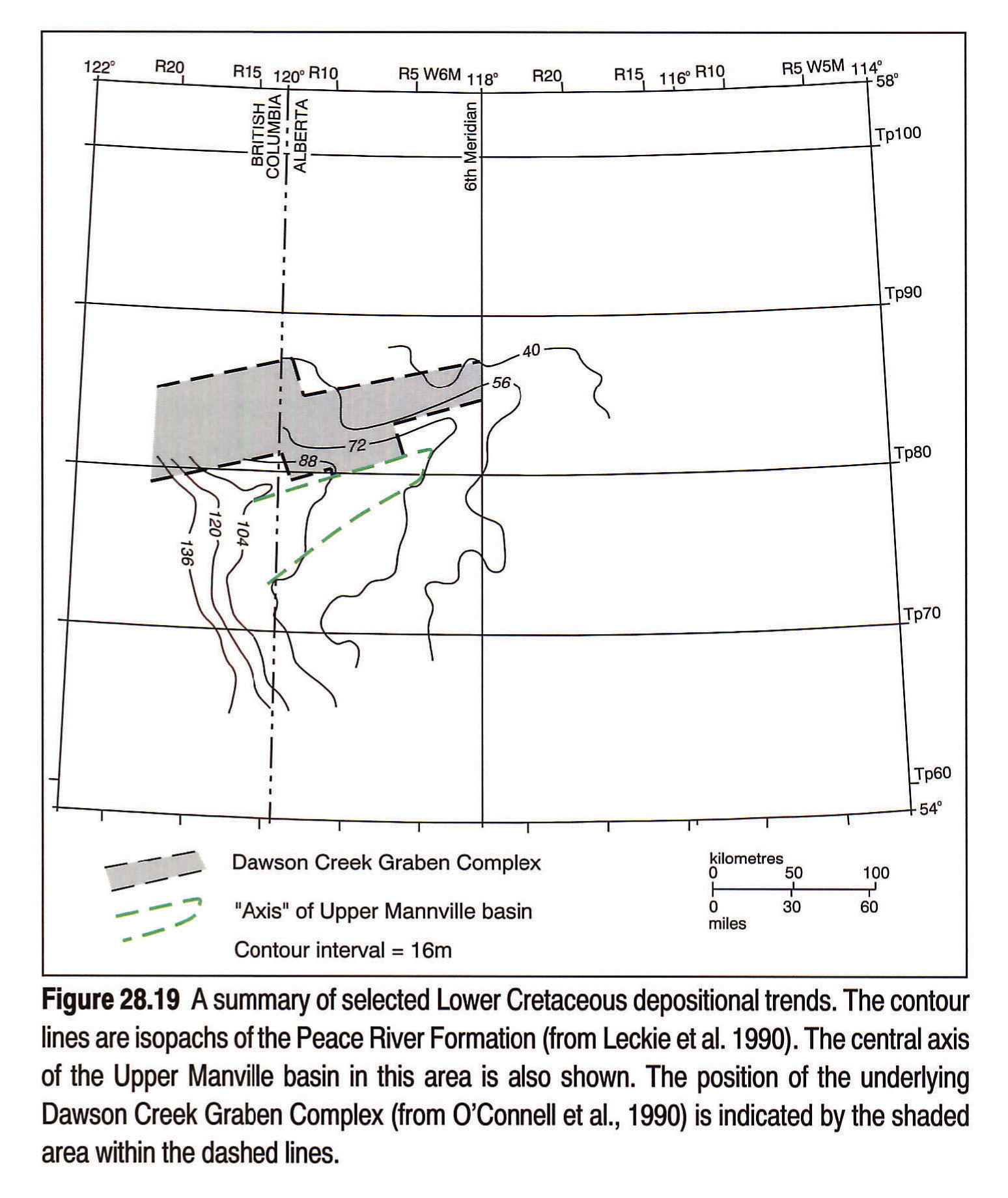
Facies distributions within the Lower Cretaceous Peace River Formation also appear to have been controlled by subsidence of the underlying DCGC structures (Leckie et al., 1990) (Fig. 28.19). Within the Cadotte Member, an abrupt transition from shoreline sandstone to offshore shale overlies the southern margin of the complex. An incised fluvial-estuarine system within the overlying Paddy Member parallels this shoreline, and the southern edge of the DCGC (Leckie et al., 1990). In the Peace River region there are many minor structural offsets within units throughout the Cretaceous, possibly caused by the reactivation of underlying PRA/DCGC structures (Cant, 1988; Hart and Plint, 1990).
Basement Reactivation
O'Connell et al. (1990) demonstrated a spatial correspondance between the northerly trending Ksituan-Chinchaga Precambrian basement contact in the Peace River region (Fig. 6) and various Phanerozoic sedimentary and structural trends. Four examples of colinearity are described:
- A prominent line of north-south-trending grabens filled with Granite Wash sediments roughly parallels the Ksituan-Chinchaga basement contact (Fig. 28.8).
- The distribution of dolomite within the Wabamun Formation, which may in part be emplaced by post-depositional fracturing (Stoakes, 1987; Churcher and Majid, 1989) has a linear trend that appears to correspond with the basement contact.
- The southeasterly offset at the eastern end of the FSJG (Figs.28.14, 28.15, 28.16) coincides with the Ksituan-Chinchaga basement contact.
- The Fox Creek Escarpment is an Early Cretaceous erosional escarpment that is colinear with the basement contact (O'Connell et al., 1990).
The correspondence between these features does not prove that a direct cause-effect relation exists, but they indicate the possibility that regionally significant Precambrian fault zones in the Peace River area were rejuvenated during the Phanerozoic.
Arch History and Origin - Summary And Discussion
The history of the PRA can be divided into three phases, giving rise to three main structural manifestations: the arch, the embayment, and the zone of enhanced subsidence in the foreland basin. These phases are as follows.
Precambrian to Early Carboniferous- uplift, onlap, and burial.The PRA probably was uplifted during the latest Proterozoic. The arch formed inboard of, and perpendicular to, the passive continental margin, and perpendicular to existing basement structural trends. It was established along the same trend as a pre-existing structure at the Late Proterozoic Windermere basin margin. The PRA is an asymmetrical structure, with greater subsidence to the north. The initial asymmetrical configuration of the arch persisted throughout the Devonian and may have been controlled by a northerly dipping fault zone at the northern edge of the arch (O'Connell et al., 1990).
From the Middle Cambrian until the Upper Devonian, the preserved succession documents a change from active uplift and onlap to a more passive onlap, and eventually a nearly complete burial of the arch. The graben structures along the crest of the arch appear to result from the flexure associated with initial uplift.
Local structural modification throughout the Devonian resulted in the formation of unconformities and influenced the distribution of carbonate and siliciclastic sediments around the arch. The development of units onlapping the arch was also influenced by regional factors such as enhanced basinal subsidence and changes in regional sediment sources. The main regional influences that appear to have controlled the onlap of the arch throughout the Devonian are tectonic subsidence of the passive margin and regional tectonic stresses resulting from the influence of various bounding tectonic regimes (Dix, 1990). These latter factors have overprinted the effects of global eustatic fluctuation (Moore, 1989) and have particularly influenced the Upper Devonian shelf/slope successions, which contain many structural and stratigraphic discontinuities.
The arch was buried by the beginning of the Carboniferous, but remained as an underlying stable element. General subsidence to the north and east of the arch continued throughout the Devonian. A region of enhanced subsidence developed to the north of the arch during the deposition of the Banff and Pekisko formations, and these formations thin over the crest of the arch.
Early Carboniferous to Jurassic- extension, uplift, and subsidence. Local syndepositional anomalies within the Banff and Pekisko formations, which overlie the central arch, are the precursors of the general subsidence of the central arch core during deposition of the Debolt Formation and Stoddart Group. The formation of the Dawson Creek Graben Complex (DCGC) was the result of a long-lived episode of extension resulting in the formation of grabens that are several orders of magnitude greater in size than the grabens formed during the initial uplift of the arch. The Early Carboniferous uplift occurred over a broad region, giving rise to a transition from widespread deposition throughout the cratonic platform to deposition within a smaller embayment limited to west-central Alberta. The period of active graben formation was followed by a long, relatively passive interval marked by local subsidence during the Permian, Triassic, and Jurassic.
Jurassic and Cretaceous- regional loading and subsidence. Regional subsidence of Peace River structures occurred from the Late Jurassic onward. The structures were probably rejuvenated as a result of loading by thrust sheets (Cant, 1988). Subsidence trends and the localization of facies appear to be related to the structures of the Carboniferous DCGC rather than the Proterozoic to Devonian elements of the arch.
Origin of the Peace River Arch
Various mechanisms have been proposed for the origin and development of the Peace River Arch. The theories vary from a completely thermal origin to a non-thermal passive flexural origin, or a combination of both. One of the first theories was published by Burwash and Krupicka (1969, 1970) and Burwash et al. (1973), who postulated that potassium enrichment within the crust in the Peace River region had caused simple isostatic uplift of basement rocks. A mechanism for driving this process was suggested by Stelck et al. (1978) who proposed that continental drift over a stationary mantle hot spot might produce the required metasomatism. Stephenson et al. (1989) and Ross (1990), however, concluded that there is no geophysical evidence of large-scale crustal alteration in the Peace River region.
A thermal origin for the arch was also suggested by Cant (1988) who proposed that the PRA originated as an incipient rift extending into the continent from the Proto-Pacific ocean. Cant (1988) attempted to identify analogues for the PRA and compared it to the Middle to Late Jurassic rift of the North Sea, while acknowledging that the features developed over vastly different time scales. He also drew attention to the similarities between the PRA and the New Madrid Rift Complex of the Mississippi Embayment (Braile et al., 1986), which is interpreted as a Proterozoic rift complex that has been repeatedly reactivated throughout the Phanerozoic by regional tectonism. O'Connell et al. (1990) indicated that it is difficult to account for the asymmetrical configuration of the arch, and the enhanced subsidence in the region to the north of the arch, in a failed rift setting.
Beaumont et al. (in press) speculated that the arch may have originated as a focused flexural response to Late Proterozoic or early Paleozoic loading of the rifted continental margin and yoking with the Williston Basin, perhaps modified by in-plane stress. Direct evidence to support this theory is difficult to obtain since there are no preserved remnants of loading external to the craton at that time.
O'Connell et al. (1990) proposed that the arch may have originated as the continental extension of an oceanic fracture zone. These fractures are transverse to passive margins and may be traced into buried basement highs where they reach the continent. Arch formation was likely the result of a single, unique event similar to this, after which it remained relatively passive. Since descriptions of present-day fracture zones are vague and poorly constrained it is difficult to draw a convincing analogy to the PRA.
Origin of the Dawson Creek Graben Complex
Barclay et al. (1990) and O'Connell et al. (1990) considered the DCGC as a separate phase of development in the region with an origin essentially unrelated to that of the arch. The arch and the DCGC are obviously linked in that they formed at the same site and along approximately the same trend. This does not necessarily mean that they had a common origin, or are genetically related. The arch may have constituted a zone of weakness that focussed regional tectonic stresses during the Early Carboniferous, giving rise to the graben complex at that location. The structural configuration and development of the DCGC suggest to Barclay et al. (1990) that while the grabens are the result of crustal extension, this extension was coupled with strike-slip motion and related compressional and rotational movement. They speculated that the western Canadian Antler Orogeny may have supplied the driving force for this movement. Halbertsma (1990) suggested that the development of extension faulting during the Carboniferous is the result of thermal uplift. O'Connell et al. (1990) suggested that the DCGC may have resulted from the development of an incipient rift.
The origin of the PRA/DCGC remains enigmatic. No published theory satisfies all the major aspects of arch development, nor has any satisfactory analogue been identified. The development of a comprehensive theory of origin is dependent upon the acquisition of new data, particularly dealing with basement structure and the identification of specific structural styles throughout the Phanerozoic.
Acknowledgements
I would like to acknowledge the Alberta Geological Survey's support for Peace River Arch studies, without which this synthesis could not have been written. This chapter relies heavily upon the work of Jim Barclay and George Dix, and I wish to acknowledge their contributions with thanks. Sebastian Bell and Doug Cant reviewed this chapter and provided many valuable comments.
References
- Aitken, J.D. 1989. The Sauk sequence: Cambrian to Lower Ordovician miogeocline and platform. In: The Western Canada Sedimentary Basin - A Case History. B.D. Ricketts (ed.). Canadian Society of Petroleum Geologists, Special Publication no. 30, Calgary, Alberta, p. 105-120.
- Anderson, N.L., Hills, L.V., and Cederwall, D.A. 1989. Geophysical atlas of Western Canadian hydrocarbon pools. Canadian Society of Exploration Geophysicists - Canadian Society of Petroleum Geologists, 344 p.
- Bamber, E.W., Macqueen, R.W., and Richards, B.C. 1980. Facies relationships at the Mississippian carbonate margin, western Canada. Geological Survey of Canada, Open File Report OF674, 18 p.
- Barclay, J.E., Krause, F.F., Campbell, R.I., and Utting J. 1990. Dynamic casting of a graben complex: Basin infill and differential subsidence during the Permo-Carboniferous; Peace River Embayment, Western Canada. Bulletin of Canadian Petroleum Geology, v. 38A, p. 115-145.
- Beaumont, C., Quinlan, G., and Stockmal, G.S. (in press). The evolution of the western interior basin: causes, consequences and unsolved problems. In: Geodynamic Evolution of the Western Interior Basin. Geological Association of Canada, Special Paper.
- Braile, L.W., Hinze, W.J., Keller, G.R., Lidiak, E.G., and Sexton, J.L. 1986. Tectonic development of the New Madrid rift complex, Mississippi Embayment, North America. Tectonophysics, v. 131, p. 1-21.
- Burrowes, O.G. and Krause, F.F. 1987. Overview of the Devonian system: subsurface of Western Canada Basin. In: Devonian Lithofacies and Reservoir Styles in Alberta. F.F. Krause, and O.G. Burrowes (eds.). 13th Canadian Society of Petroleum Geologists Core Conference and Second Symposium on the Devonian System, p. 1-20.
- Burwash, R.A. and Krupicka, J. 1969. Cratonic reactivation in the Precambrian basement of western Canada. I. Deformation and chemistry. Canadian Journal of Earth Sciences, v. 6, p. 1381-1396.
- Burwash, R.A. and Krupicka, J. 1970. Cratonic reactivation in the Precambrian basement of western Canada. II. Metasomatism and isostasy. Canadian Journal of Earth Sciences, v. 7, 1275-1294.
- Burwash, R.A., Krupicka, J., and Culbert, R.R. 1973. Cratonic reactivation in the Precambrian basement of western Canada. III. Crustal evolution. Canadian Journal of Earth Sciences, v. 10, p. 283-291.
- Burwash, R.A., McGregor, C.R., and Wilson, J.A. (this volume). Precambrian basement beneath the Western Canada Sedimentary Basin. In: Geological Atlas of the Western Canada Sedimentary Basin. G.D. Mossop and I. Shetsen (comps.). Calgary, Canadian Society of Petroleum Geologists and Alberta Research Council, chpt. 5.
- Campbell, C.V. 1987. Stratigraphy and facies of the Upper Elk Point Subgroup, northern Alberta. In: Devonian Lithofacies and Reservoir Styles in Alberta. F.F. Krause, and O.G. Burrowes, (eds.). 13th Canadian Society of Petroleum Geologists Core Conference and Second Symposium on the Devonian System, p. 243- 286.
- Cant, D. J. 1984. Development of shoreline-shelf sand bodies in a Cretaceous epeiric sea deposit. Journal of Sedimentary Petrology, v. 54, p. 541-556.
- Cant, D.J. 1988. Regional structure and development of the Peace River Arch, Alberta: a Paleozoic failed-rift system? Bulletin of Canadian Petroleum Geology, v. 36, p. 284-295.
- Chatellier, J.-Y. 1988. Carboniferous carbonate ramp, the Banff Formation, Alberta, Canada. Bulletin des Centres de Recherches Exploration - Production Elf-Aquitaine, v. 12, p. 569-599.
- Churcher, P.L. and Majid, A.H. 1989. Similarities between the Tangent-Wabamun type play of the Alberta basin and the Albion-Scipio type play of the Michigan Basin. Bulletin of Canadian Petroleum Geology, v. 37, p. 241-245.
- DeMille, G. 1958. Pre-Mississippian history of the Peace River Arch. Journal of the Alberta Society of Petroleum Geologists, v. 6, p. 61-68.
- Dix, G.R. 1990. Stages of platform development in the Upper Devonian (Frasnian) Leduc Formation, Peace River Arch, Alberta. Bulletin of Canadian Petroleum Geology, v. 38A, p. 66-92.
- Douglas, R.J.W. 1970. Carboniferous and Permian. In: Geology and Economic Minerals of Canada. R.J.W. Douglas (ed.). Geological Survey of Canada, Economic Geology Report no. 1, p. 411-421.
- Fischbuch, N.R. 1968. Stratigraphy, Devonian Swan Hills reef complexes, Alberta. Bulletin of Canadian Petroleum Geology, v. 16, p. 446-587.
- Geldsetzer, H.H. 1988. Ancient Wall reef complex, Frasnian age, Alberta. In: Reefs, Canada and Adjacent Areas. H.H. Geldsetzer, N.P. James and G.E. Tebbut (eds.). Calgary, Canadian Society of Petroleum Geologists, Memoir 13, p. 431-439.
- Gibson, D.W. 1992. Stratigraphy, sedimentology, coal geology and depositional environments of the Lower Cretaceous Gething Formation, Northeastern British Columbia and west-central Alberta. Geological Survey of Canada, Bulletin 431, 127 p.
- Gibson, D.W. and Barclay, J.E. 1989. Middle Absaroka Sequence: The Triassic stable craton. In: The Western Canada Sedimentary Basin - A Case History. B.D. Ricketts (ed.). Calgary, Canadian Society of Petroleum Geologists, Special Publication no. 30, p. 219-232.
- Gibson, D.W. and Edwards D.E. 1990. An overview of Triassic stratigraphy and depositional environments in the Rocky Mountain Foothills and Western Interior Plains, Peace River Arch area, northeastern British Columbia. Bulletin of Canadian Petroleum Geology, v. 38A, p. 146-158.
- Gosselin, E.G., Smith, L., and Mundy, D.J.C. 1989. The Golden and Evi reef complexes, Middle Devonian, Slave Point Formation, northwestern Alberta. In: Reefs, Canada and adjacent areas. H.H.J. Geldsetzer, N.P. James and G.E. Tebbutt (eds.). Canadian Society of Petroleum Geologists, Memoir 13, p. 440-447.
- Halbertsma, H.L. 1990. Extension faulting in the Western Canada Sedimentary Basin and the collapse of the Peace River Arch (abstract). Program and Abstracts, Canadian Society of Petroleum Geologists Convention, Calgary, p. 61.
- Halbertsma, H.C. and Meijer Drees, N.C. 1987. Wabamun limestone sequences in north-central Alberta. In: Devonian Lithofacies and Reservoir Styles in Alberta. F.F. Krause and O.G. Burrowes (eds.). Calgary, Second International Symposium on the Devonian System, p. 21-37.
- Hart, B. S. and Plint, A.G. 1990. Upper Cretaceous warping and fault movement on the southern flank of the Peace River Arch, Alberta. Bulletin of Canadian Petroleum Geology, v. 38A, 190-195.
- Jones, R.M.P. 1980. Basinal isostatic adjustment faults and their petroleum significance. Bulletin of Canadian Petroleum Geology, v. 28, p. 211-251.
- Keith, J.W. 1990. The influence of the Peace River Arch upon Beaverhill Lake sedimentation. Bulletin of Canadian Petroleum Geology, v. 38A, p. 55-65.
- Lavoie, D.H. 1958. The Peace River Arch during Mississippian and Permo-Pennsylvanian time. Journal of the Alberta Society of Petroleum Geologists, v. 6, p. 69-74.
- Leckie, D. 1986. Rates, controls and sand-body geometries of transgressive-regressive cycles: Cretaceous Moosebar and Gates formations, British Columbia. American Association of Petroleum Geologists, Bulletin, v. 70, p. 516-535.
- Leckie, D., Staniland, M.R., and Hayes, B.J. 1990. Regional maps of the Albian Peace River and lower Shaftsbury formations on the Peace River Arch, northwestern Alberta and northeastern British Columbia. Bulletin of Canadian Petroleum Geology, v. 38A, p. 176-189.
- Lorenz, J.C. 1982. Lithospheric flexure and the history of the Sweetgrass Arch in northwestern Montana. In: Geological Studies of the Cordilleran Thrust Belt: R.B. Powers (ed.). Rocky Mountain Association of Geologists, Denver, Colorado, p. 77-89.
- Macauley, G., Penner, D.G., Proctor, R.M., and Tisdell, W.H. 1964. Carboniferous. In: Geological History of Western Canada. R.G. McCrossan and R.P. Glaister (eds.). Alberta Society of Petroleum Geologists, Calgary, Alberta, p. 89-102.
- McMechan, M.E. 1990. Upper Proterozoic to Middle Cambrian history of the Peace River Arch: evidence from the Rocky Mountains. Bulletin of Canadian Petroleum Geology, v. 38A, p. 36-44.
- Meijer Drees, N.C. 1986. Evaporitic deposits of Western Canada. Geological Survey of Canada, Paper 85-20, 118 p.
- Meijer Drees, N.C. (this volume). Devonian Elk Point Group of the Western Canada Sedimentary Basin. In: Geological Atlas of the Western Canada Sedimentary Basin. G.D. Mossop and I. Shetsen (comps.). Calgary, Canadian Society of Petroleum Geologists and Alberta Research Council, chpt. 10.
- Meijer Drees, N.C., Johnston, D.I. and Fullmer, E.G. (in press). Devonian formations across Peace River Arch, west-central Alberta and nearby British Columbia. Geological Survey of Canada, Open File.
- Moore, P.F. 1989. The Kaskaskia Sequence: reefs, platforms and foredeeps - the Lower Kaskaskia Sequence - Devonian. In: The Western Canada Sedimentary Basin - A Case History. B.D. Ricketts (ed.). Canadian Society of Petroleum Geologists, Special Publication no. 30, Calgary, Alberta, p. 139-164.
- Moore, P.F. 1988. Devonian geohistory of the western interior of Canada. In: Devonian of the World, v. 1. N.J. McMillan, A.F. Embry and D.J. Glass, (eds.). Calgary, Canadian Society of Petroleum Geologists, Memoir 14, p. 67-84.
- Norford, B.S. 1990. Ordovician and Silurian stratigraphy, palaeogeography and depositional history of the Peace River Arch area, Alberta and British Columbia. Bulletin of Canadian Petroleum Geology, v. 38A, p. 45-54.
- Norris, D.K. and Price, R.A. 1966. Middle Cambrian lithostratigraphy of southeastern Canadian Cordillera. Bulletin of Canadian Petroleum Geology, v. 14, p. 385-404.
- O'Connell, S.C. 1990. The development of the Lower Carboniferous Peace River Embayment as determined from Banff and Pekisko formation depositional patterns. Bulletin of Canadian Petroleum Geology, v. 38A, p. 93-114.
- O'Connell, S.C. 1992. Parasequence development in a Lower Cretaceous transgressive systems tract: the Gething and Bluesky formations of northwestern Alberta, Canada. SEPM theme meeting "Mesozoic of the Western Interior", Ft. Collins Colorado. Conference Abstracts, p. 51.
- O'Connell, S.C., Dix, G.R., and Barclay, J.E. 1990. The origin, history, and regional structural development of the Peace River Arch, Western Canada. Bulletin of Canadian Petroleum Geology, v. 38A, p. 4-24.
- Podruski, J.A. 1988. Contrasting character of the Peace River and Sweetgrass arches, Western Canada Sedimentary Basin. Geoscience Canada, v. 15, p. 94-97.
- Podruski, J.A., Barclay, J.E., Hamblin, A.P., Lee, P.J., Osadetz, K.G., Procter, R.M., and Taylor, G.C. 1988. Conventional oil resources of western Canada. Part 1: Resource endowment. Geological Survey of Canada, Paper 87-26, p. 1-126.
- Poulton, T.P., Tittemore, J., and Dolby, G., 1990. Jurassic stratigraphy, northwestern Alberta and northeastern British Columbia. Bulletin of Canadian Petroleum Geology, v. 38A, p. 159-175.
- Pugh, D.C. 1973. Subsurface lower Paleozoic stratigraphy in northern and central Alberta. Geological Survey of Canada, Paper 72-12, 54 p.
- Richards, B.C. 1989. Upper Kaskaskia Sequence: uppermost Devonian and Lower Carboniferous. In: Western Canada Sedimentary Basin - A Case History. B.D. Ricketts (ed.). Canadian Society of Petroleum Geologists, Special Publication no. 30, Calgary, Alberta, p. 164-201.
- Ross, G.M. 1990. Deep crust and basement structure of the Peace River Arch region: constraints on mechanisms of formation. Bulletin of Canadian Petroleum Geology, v 38A, p. 25-35.
- Sikabonyi, L.A. and Rodgers, W.J. 1959. Paleozoic tectonics and sedimentation in the northern half of the west Canadian basin. Journal of the Alberta Society of Petroleum Geologists, v. 7, p. 193-216.
- Smith, D.G., Zorn, C.E., and Sneider, R.M. 1984. The paleogeography of the Lower Cretaceous of western Alberta and northeastern British Columbia in and adjacent to the Deep Basin of the Elmworth area. In: Elmworth - Case Study of a Deep Basin Gas Field. J.A. Masters (ed.). American Association of Petroleum Geologists, Memoir 38, p. 153-172.
- Stelck, C.R., Burwash, R.A., and Stelck, D.R. 1978. The Vreeland High: a Cordilleran expression of the Peace River Arch. Bulletin of Canadian Petroleum Geology, v. 26, p. 87-104.
- Stephenson, R.A., Zelt, C.A., Ellis, R.M., Hajnal, Z., Morel-a-l'Huissier, P., Mereu, R.F., Northey, D.J., West, G.F., and Kanasewich, E.R. 1989. Crust and upper mantle structure and the origin of the Peace River Arch. Bulletin of Canadian Petroleum Geology, v. 37, p. 224-235.
- Stoakes, F. 1987. Fault-controlled dolomitization of the Wabamun Group, Tangent field, Peace River Arch, Alberta. In: Devonian Lithofacies and Reservoir Styles in Alberta. F. F. Krause and O.G. Burrowes (eds.). Calgary, Second International Symposium on the Devonian System, p. 73-86.
- Stoakes, F. 1988. Evaluation of the Upper Devonian of Western Canada. In: Principles and Concepts for the Exploration of Reefs in the Western Canada Basin. G.R. Bloy and M. Charest (eds.). Short Course Notes. Canadian Society of Petroleum Geologists, Calgary.
- Stott, D.E. 1973. Lower Cretaceous Bullhead Group between Bullmoose Mountain and Tetsa River, Rocky Mountain Foothills, northeastern British Columbia. Geological Survey of Canada, Bulletin 219, 228 p.
- Trotter, R. 1989. Sedimentology and depositional setting of the Granite Wash of the Utikuma and Red Earth areas, north-central Alberta. Unpublished M.Sc. thesis, Dalhousie University. 378 p.
- Trotter, R. and Hein, F.J. 1988. Sedimentology and depositional setting of the Granite Wash, northwestern Alberta. In: Sequences, Stratigraphy, Sedimentology: Surface and Subsurface. D.P. James and D.A. Leckie, (eds.). Canadian Society of Petroleum Geologists, Memoir 15, p. 475-484.
- van Hees, H. 1964. Cambrian. Part I - Plains. In: Geological History of Western Canada. R.G. McCrossan and P.R. Glaister (eds.). Alberta Society of Petroleum Geologists, p. 230-312.
- Williams, G.K. 1958. Influence of the Peace River Arch on Mesozoic strata. Journal of the Alberta Society of Petroleum Geologists, v. 6, p. 74-81.
- Zelt, C.A. 1989. Seismic structure of the crust and upper mantle in the Peace River Arch region. Unpublished PhD thesis, University of British Columbia, 223 p.