Chapter 18 - Jurassic and Lowermost Cretaceous Strata of the Western Canada Sedimentary Basin |
|
| Chapter Sections |
Table 18.26a Oil production from the Jurassic Table 18.26b Gas production from the Jurassic |
Authors: T.P. Poulton - Geological Survey of Canada, Calgary J.E. Christopher - Geological Survey of Canada, Calgary B.J.R. Hayes - Consultant, Calgary J. Losert - Alberta Department of Energy, Edmonton J. Tittemore - Consultant, Calgary R.D. Gilchrist - Consultant, British Columbia Energy, Mines and Resources, Victoria Additional Contributors: R. Bezys - Manitoba Energy and Mines, Winnipeg H.R. McCabe - Consultant, Winnipeg
Introduction
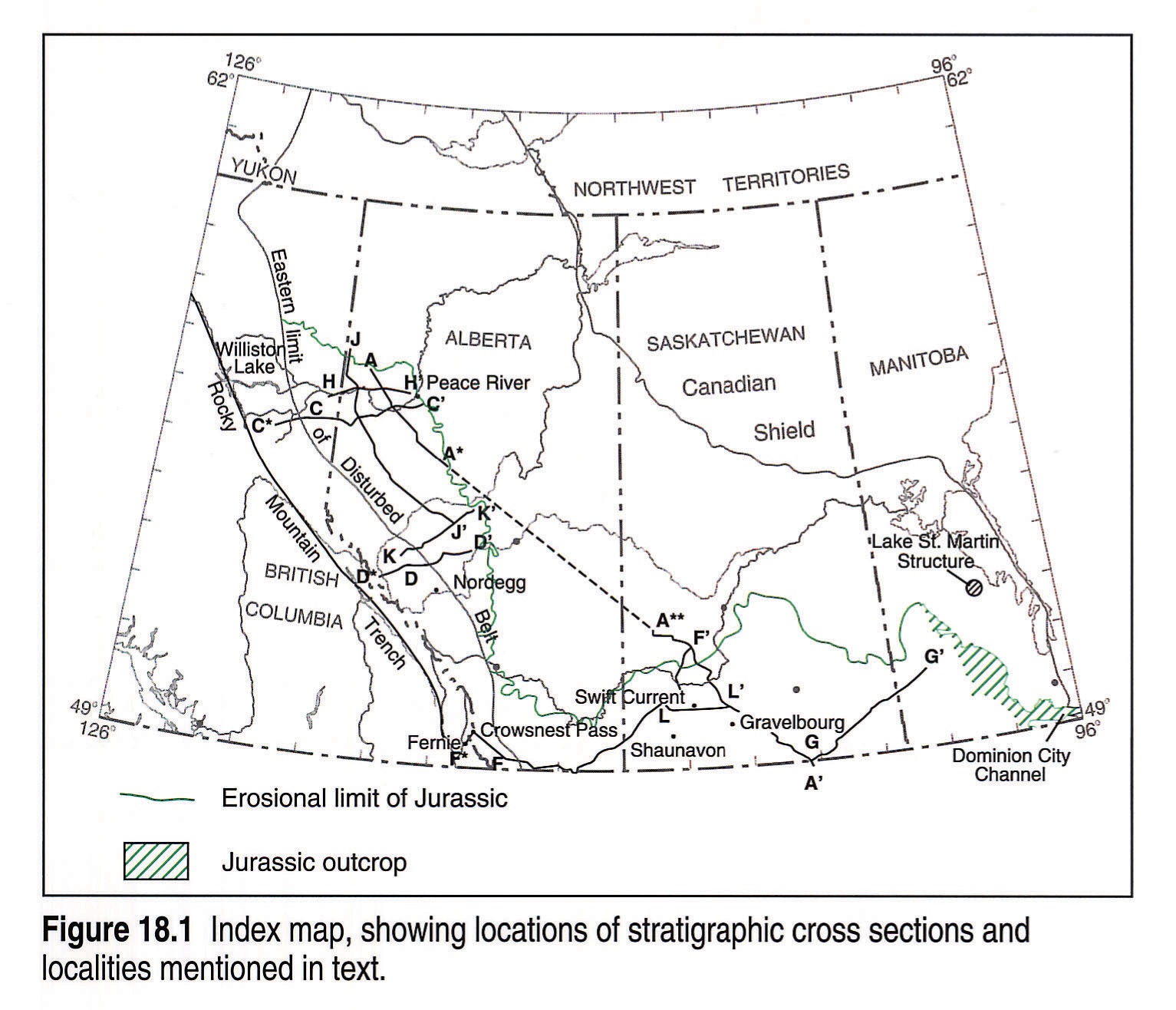
This chapter summarizes our knowledge of the distribution and character of the Jurassic and lowest Cretaceous (to about Barremian) strata of the Western Canada Sedimentary Basin (Figs. 18.1, 18.2). These strata contain the epicratonic record of the early phases of the Columbian Orogeny. Clastic rocks in the thin, stable-platform pre-orogenic assemblage are mineralogically mature, derived from cratonic sediment sources in the east, whereas the thick sequence of younger, less mature, foreland trough strata were derived largely from orogenic uplifts to the west. Farther east, the Williston Basin was characterized by pronounced downwarping in the Middle Jurassic and eventual filling in the Late Jurassic.
The Jurassic and lowest Cretaceous sedimentary rocks form significant oil and gas reservoirs in central and southern Alberta and southwestern Saskatchewan, and some are hydrocarbon source rocks in Western Canada (Creaney et al. this volume, Chapter 31). The immense coking coal reserves of the southern Canadian Rocky Mountains are found in the Upper Jurassic to lowest Cretaceous succession (Smith et al., this volume, Chapter 33). Probable Jurassic rocks in southern Manitoba host two of Canada's major gypsum mines, and some of the currently subeconomic, yttrium-enriched, phosphate deposits in southeastern British Columbia (Butrenchuk, 1987; Pell, 1991) and southwestern Alberta (Macdonald, 1987) are in Jurassic strata (Christie, 1989).
Boundary Relations
The Jurassic and lowest Cretaceous strata (as well as the basal Mesozoic redbeds in Williston Basin, which may be either Triassic or Jurassic in age) overlie a regionally unconformable erosional surface that exhibits significant local relief. Karst features are present in some of the sub-Mesozoic limestones. Some of the relief is caused by resistant Paleozoic limestone units that formed cuestas on the sub-Mesozoic surface, and some is due to subsidence in those areas affected by dissolution of Paleozoic salt units. Some of the meteorite impact craters that created relief on the sub-Mesozoic surface in southern Saskatchewan and Manitoba are Jurassic or pre-Jurassic in age (e.g., McCabe, 1971; Sawatzky, 1974).
In western Alberta and eastern British Columbia, the sub-Jurassic unconformity truncates successively older beds eastward onto the craton, from Triassic and Permian in the west, to Carboniferous in the east. In westernmost outcrops, the pre-Jurassic hiatus may have been of short duration. In Saskatchewan and Manitoba, Mesozoic strata lie on rocks as old as Devonian regionally (but as old as Precambrian in some ancient valleys in Manitoba) around the northern and eastern edges of Williston Basin.
Eastward and northward in Alberta, first lowest Cretaceous, then Jurassic strata thin and disappear, partly by shoreward depositional thinning, but largely by truncation below unconformities within the Jurassic and below the younger Lower Cretaceous Mannville Group and equivalents. The approximation of unconformities, and changes in several superposed units to shallower sandstone facies toward the east, cause particular difficulties in accurately identifying and correlating rock units in central Alberta. Jurassic strata are progressively truncated toward the north in Saskatchewan and Manitoba, away from the centre of Williston Basin.
The pre-Aptian Mesozoic sequence includes thin and discontinuous, unconformity-bounded, Upper Jurassic and Lower Cretaceous sandstone units preserved in erosional lows over much of southern and central Saskatchewan and Alberta. The distribution of these units, lying across and beyond the truncated edges of older Jurassic strata, attests to the development of the major "sub-Mannville" unconformity below them in Barremian or earlier time.
Constraints
New subsurface stratigraphic data and correlations, based partly on new discoveries of ammonites and palynomorphs, are incorporated into this chapter, and further revisions are expected. Local variation in the Jurassic rock units in some areas dictates that a complete understanding of the successions must be based on a large number of closely spaced wells and stratigraphic sections with age-significant fossils. Detailed studies with good biostratigraphic control over broad areas are few, and good core material and fossils scarce. Because of generally poor exposure, deformation and high thermal alteration, the outcrops of Jurassic strata pose special problems. These constraints are reflected especially in the isopach maps for the Rocky Mountains and foothills outcrop areas, which should be considered as generalized approximations of data that are highly variable in quality.
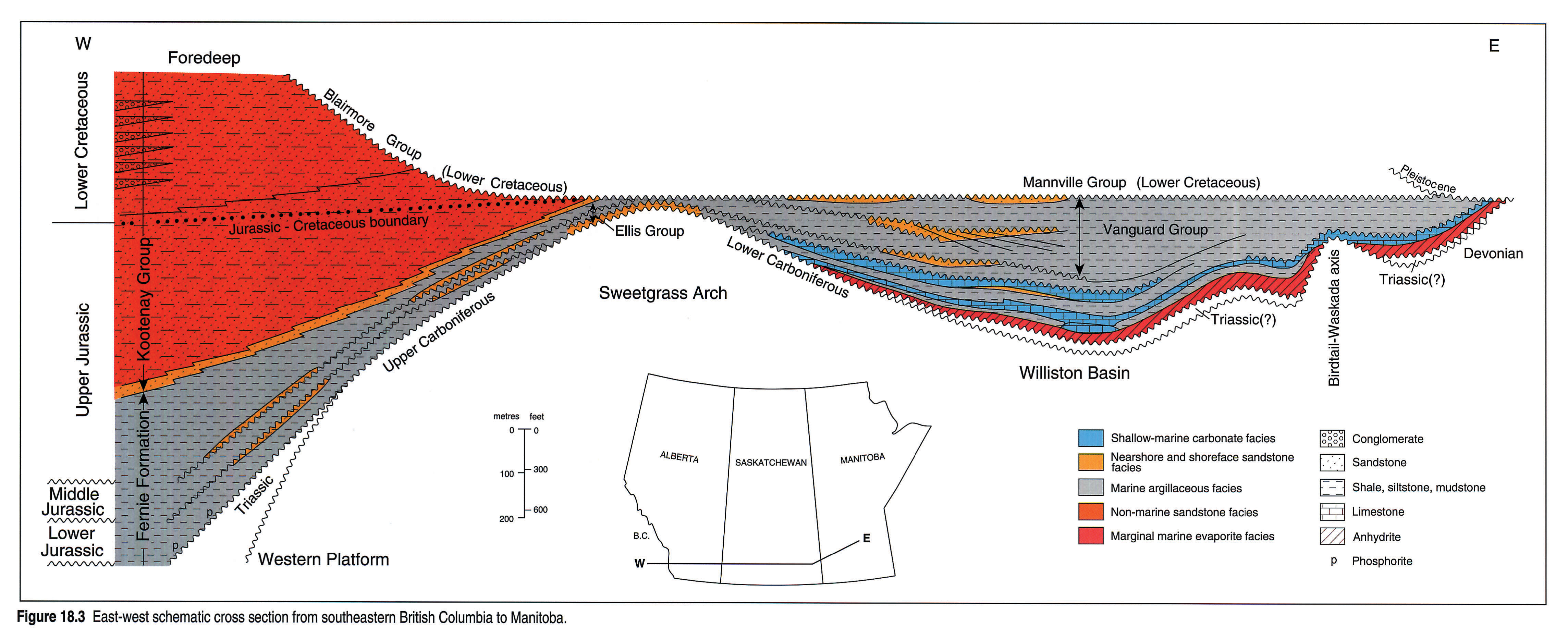
In many areas, identifying the base of the Mannville Group or equivalents where it overlies lithologically similar Upper Jurassic sandstones or shales has caused difficulty, whereas in other areas, a significant chert component differentiates the Cretaceous from the mainly quartzose Jurassic strata. Where Lower Jurassic limestones lie above Carboniferous limestones in central Alberta, or above Triassic limestones in the subsurface of northeastern British Columbia, the contact is commonly difficult to place. Correlations within the Jurassic and lowest Cretaceous succession remain highly interpretive in many areas. In particular, correlations across the Sweetgrass Arch and the Birdtail-Waskada axis (Fig. 18.2b, 18.3), that is, from southern Alberta into southern Saskatchewan, and from there into southern Manitoba, are poorly supported by paleontology and still contain uncertainties.
This compilation has involved re-picking of formation tops over major areas of northeastern British Columbia (Gilchrist), northern Alberta (Tittemore), southern Alberta (Hayes), Saskatchewan (Christopher), and Manitoba (McCabe). The small number of wells controlled by Canstrat studies in southern Saskatchewan and Manitoba places limits on the reliability of the lithofacies maps in these areas.
Previous Work
The Jurassic and lowest Cretaceous strata of the Rocky Mountains and foothills outcrop belt have been the subject of several in-depth studies. A few detailed subsurface studies have been undertaken in small areas of Alberta and Manitoba, and most of southern Saskatchewan. Major summaries and sources for additional reports on the Jurassic and lowest Cretaceous of the Western Canada Sedimentary Basin include reports by Springer et al. (1964), Stott (1970) and Poulton (1984, 1989). Reports synthesizing specific large parts of the region, and providing access to more detailed studies, include those by Frebold (1957, 1969), Stott (1967, 1984), Hall (1984), Stronach (1984), Christopher (1964, 1974, 1984), Gibson (1985) and Poulton et al. (1990).
Geological Framework
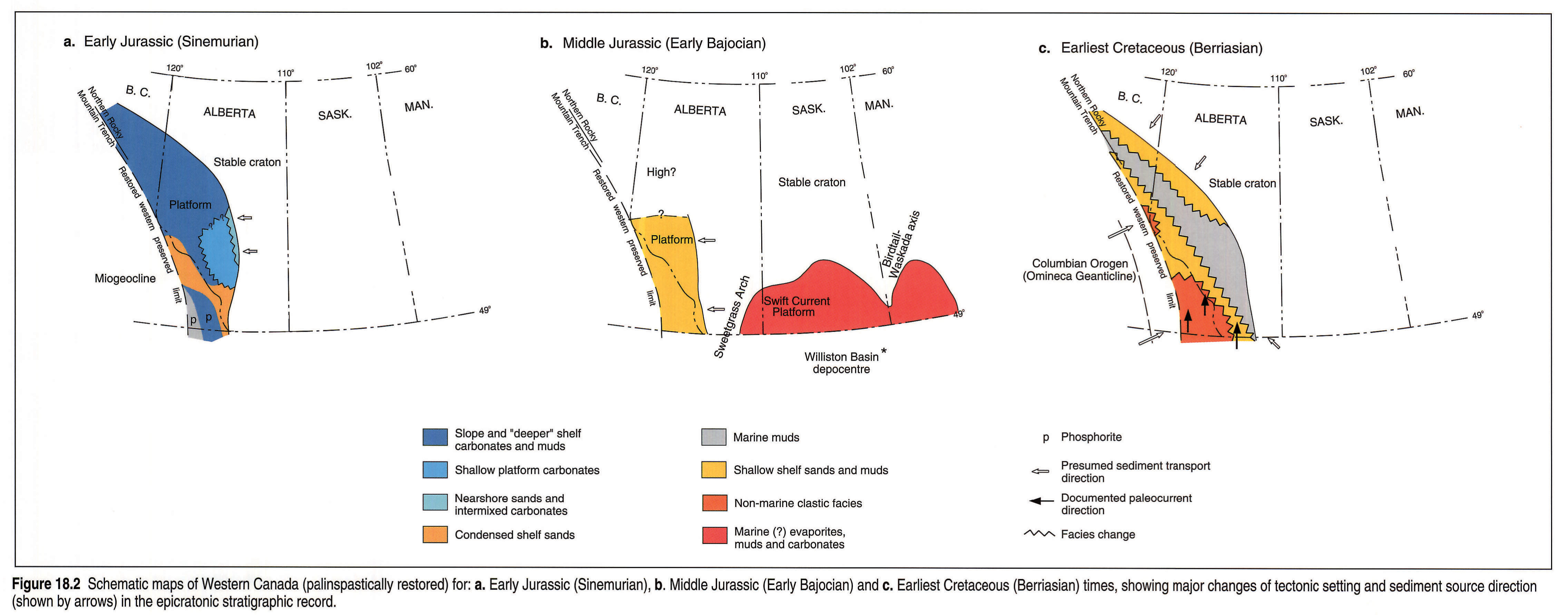
Jurassic rocks occur in three major epicratonic depositional settings: on western parts of the pre-orogenic, essentially stable cratonic platform or shelf; in the succeeding foreland trough or foredeep superimposed on the same area - the Rocky Mountain Trough; and in Williston Basin (Figs. 18.2 and 18.3).
Pre-orogenic Western Platform
The pre-orogenic Lower Jurassic sequences are thin and consist of platformal limestones and cherts, and widespread, starved-shelf, phosphatic, organic-rich shales, limestones, and sandstones separated by disconformities (Fig. 18.4). In contrast, the Middle Jurassic strata consist of more localized, slightly thicker siliciclastic units. It is unclear to what extent, if any, deposition of the Lower Jurassic strata over the regional sub-Jurassic unconformity indicates subsidence that might be related to western tectonic events.
The western platform perhaps was less stable during the Early and Middle Jurassic than is generally thought, as indicated by the differences from one place to another in the units deposited and preserved, and the depth of erosion at unconformities within the Jurassic. For example, a major pre-Late Jurassic erosional event removed most of whatever Middle Jurassic strata were deposited in a broad area in northeastern British Columbia and northwestern Alberta, across and well beyond the limits of the much older Peace River Arch (Poulton et al., 1990). Thickening of the Jurassic succession in small areas in the Peace River region suggests localized Jurassic subsidence or differential compaction over Paleozoic fault blocks and grabens (Poulton et al., 1990), but there is no major Jurassic expression of the Peace River Arch or Embayment. Some of the thickness and facies variations might suggest early effects of initial Cordilleran orogenic events underway to the west (e.g., Poulton, 1984).
No western margins or hingelines (with abrupt westward thickening) are preserved for the Lower and Middle Jurassic basin to confirm the presence of the miogeoclinal package that is assumed, in current tectonic models, to have lain west of the platform.
Rocky Mountains Foreland Trough
The coarsening- and shallowing-upward succession that begins with Upper Jurassic marine shales (or a locally developed basal sandstone) and is dominated by basin fill, primarily non-marine sandstones, makes up the first undisputed orogenic foreland trough deposits. It is the first of several, westerly derived, orogenic clastic wedges, and extends into the lowest Cretaceous.
The narrow foreland trough (Fig. 18.2c), elongated parallel to the present Rocky Mountain front, was superimposed on underlying, more evenly distributed, Lower and Middle Jurassic rocks. Insofar as the orogenic wedge strata become thicker to the west, the depositional axis of the trough lay west of their western preserved limit.
In southwestern Alberta and southeastern British Columbia, paleocurrent directions in Upper Jurassic strata indicate generally northerly transport (Norris, in Poulton, 1984; Hamblin and Walker, 1979). The interpretation of western orogenic sources, primarily upthrust epicratonic Paleozoic strata (Gibson, 1985), for most of the foreland trough-fill in southern Canada, involves re-orientation of currents in the non-marine, shoreline and offshore deposits to a northward, basin-axial direction, even in the most westerly strata known. Diachroneity at the base of the orogenic sandstones is unproven paleontologically, and accordingly, the figures in this chapter offer alternative interpretations. A few extra-basinal metamorphic clasts have been recognized in the sub-Cadomin conglomerates in the south (Jansa, 1972). In northeastern British Columbia, western source terranes are clearly indicated by metamorphic and exotic chert clasts (M. McMechan in Poulton, 1984; Gabrielse and Yorath, 1989). Uplifted parts of the former Williston Basin may have served as a southern or southeastern source for some of the detritus (Stelck et al., 1972).
Initial orogenic clastic wedges vary in age from Late Jurassic in southern Alberta and British Columbia, to Cretaceous in the northern Yukon (Poulton, 1984). This northward progression of initial foreland trough sedimentation may be an indication of a similar shift in accretionary uplifts to the west, such as the northward motion of westerly source areas along large-scale dextral strike-slip faults lying along the western side of the Omineca Belt (Eisbacher, 1981).
Williston Basin
Williston Basin (Figs. 18.2b, 18.3) was rejuvenated and subsided during the Jurassic. The earliest paleontologically dated Jurassic deposits are early Middle Jurassic (Bajocian). More axial parts of the basin underwent increased subsidence rates during the later Middle Jurassic. Williston Basin was filled, and the area was involved in regional uplift, in the Late Jurassic.
Sweetgrass Arch, separating the western parts of the platform from Williston Basin, was a paleotopographic high during most of the Jurassic, and was transgressed progressively beginning in the Bajocian. The broad Swift Current Platform forms the stable northwestern part of the basin, with a heterogenous shallow-marine sequence recording a complex history of sea-level fluctuations.
The Birdtail-Waskada axis (McCabe, 1967, 1971) coincides with the Thompson Boundary Fault of Kent and Christopher (this volume, Chapter 27) and with the eastern part of the Precambrian Trans-Hudson Orogen that separates the Superior and western Archean provinces (Hoffman, 1989). It was a paleotopographic high during the Middle Jurassic, and is characterized by structural and geophysical anomalies at several levels in the geological column. During the early Middle Jurassic the axis separated the northeastern portion of Williston Basin in Manitoba from the main part of northern Williston Basin in Saskatchewan (Figs. 18.2b, 18.3).
In Manitoba, the Jurassic/Triassic evaporite and redbed succession at the base of the Mesozoic is preserved within a major pre-Mesozoic valley system (the Dominion City Channel; see Fig. 18.1 and Corkery, 1987), which was incised as deep as Precambrian Shield rocks. The redbeds and evaporites overlie probable Permian meteorite impact breccias and melt rocks in an outlier in the Lake St. Martin's impact structure (Fig. 18.1). Major regional peneplanation and valley formation occurred over all but the westernmost parts of the Western Canada Sedimentary Basin area during the mid-Early Cretaceous, prior to deposition of poorly understood sandstones in or about Barremian time. These depositional events were, in turn, succeeded by another regional erosional event prior to deposition of the Mannville and Blairmore groups, beginning in about the Aptian.
Stratigraphy
Stratigraphic Nomenclature and Reference Logs
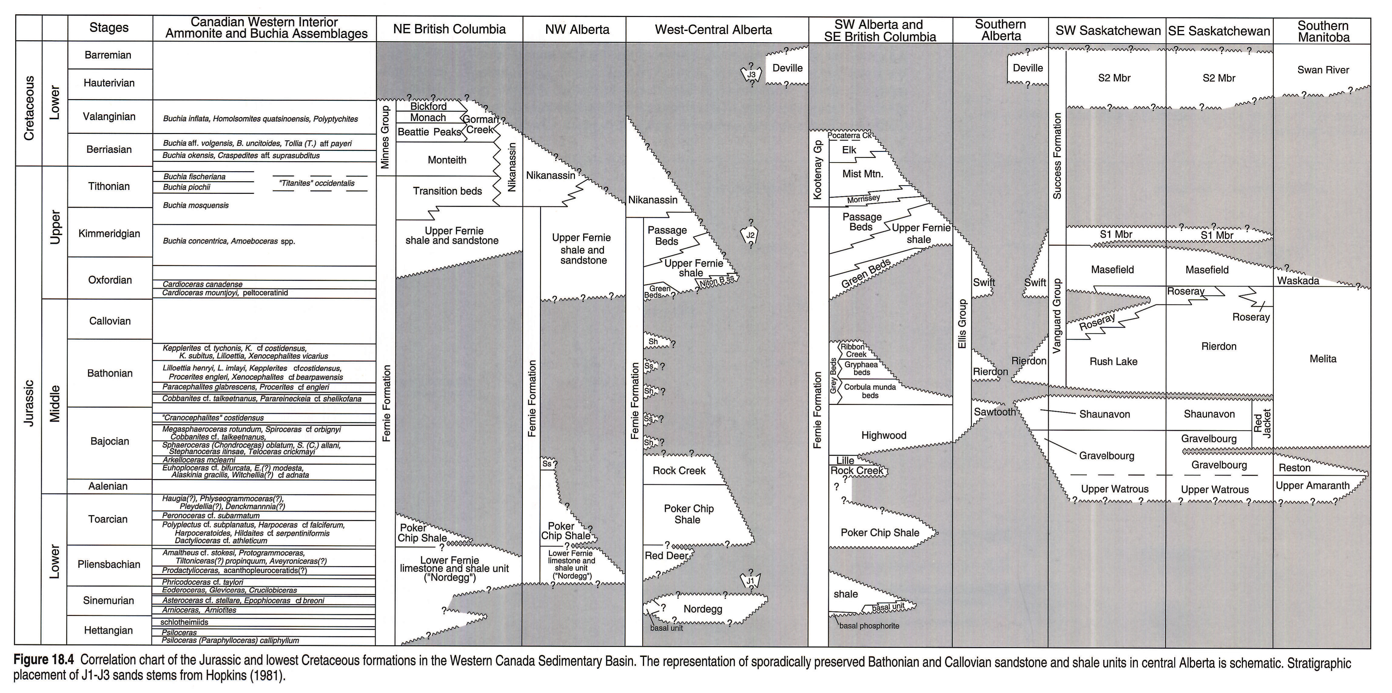
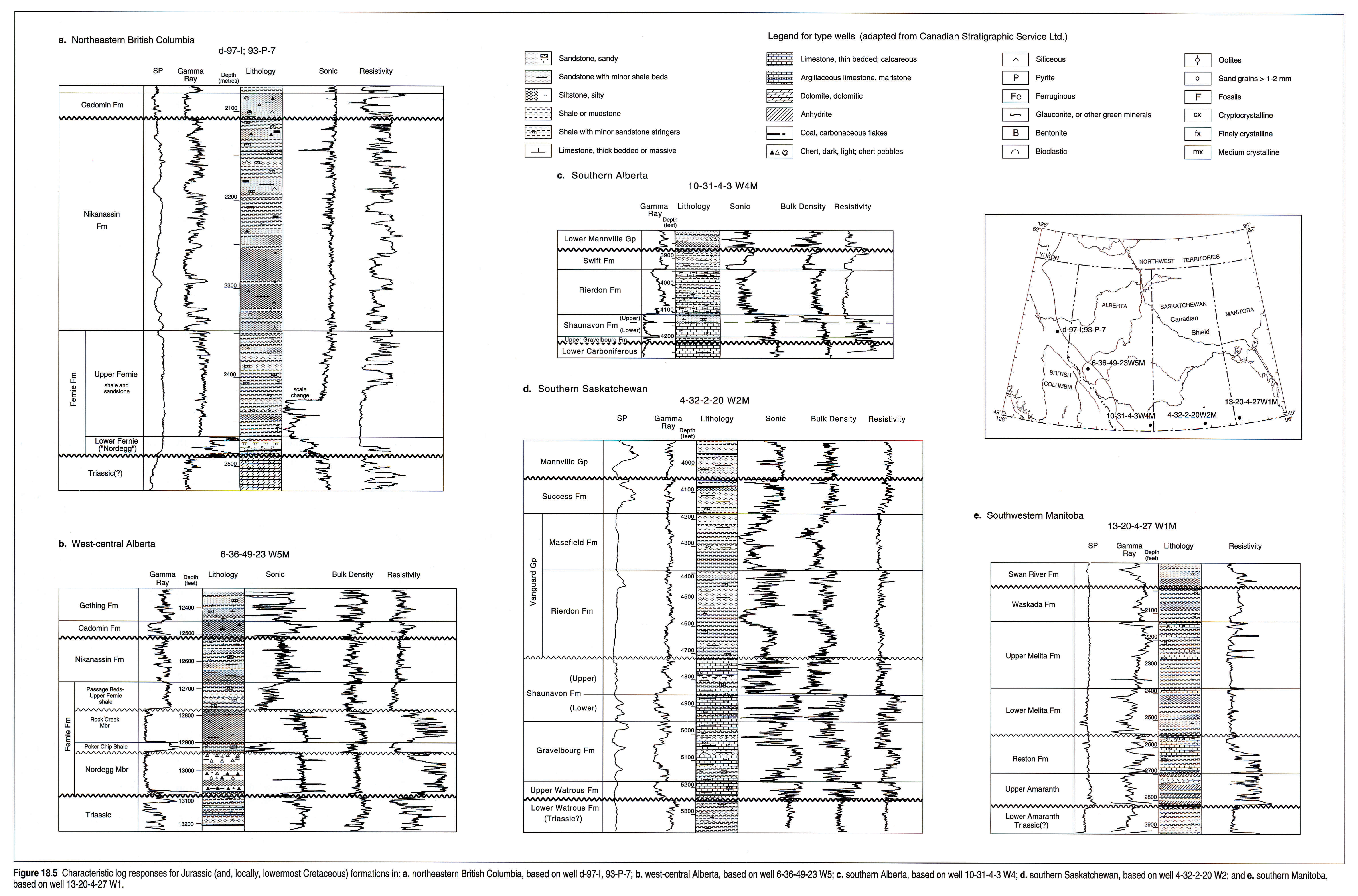
All but the uppermost Jurassic strata of western Alberta and eastern British Columbia (east of the Rocky Mountain Trench) are assigned to the Fernie Formation (Fig. 18.4), a dominantly shaly unit first named in the Crowsnest Pass area of southeastern British Columbia (McEvoy, 1902). The Fernie has been treated as a group (Frebold, 1957) but no formations have been defined within it. It contains a number of members and informal units, the mutual relations and continuity of which are still subject to revision (e.g., Frebold, 1957; Stott, 1967; Hall, 1984; Poulton et al., 1990).
Northeastern British Columbia to West-central Alberta
The highly radioactive unit at the base of the Fernie Formation in northeastern British Columbia and northwestern Alberta (Fig. 18.5a; Riediger et al., 1990) is generally assigned to the Nordegg Member. However it is different lithologically from the Nordegg in its type area, more closely resembling the Red Deer Member of southwestern and west-central Alberta, and is here called the Lower Fernie limestone and shale unit. This unit is a regionally uniform, phosphatic, organic-rich, platy limestone and shale containing Lower Pliensbachian ammonites in surface exposures in the Halfway River map area (Poulton et al., 1990). Its age makes this unit approximately synonymous with the Red Deer Member of west-central Alberta, which, however, has so far yielded only Upper Pliensbachian ammonites (see Fig. 18.4). Older fossiliferous siltstones, in part Hettangian in age, occur at the base of the Jurassic in outcrops in northeastern British Columbia (Tozer, 1982; Poulton et al., 1990).
In contrast, the Nordegg Member in the subsurface east of its exposed type area in west-central Alberta is a massive, light gray, chert and limestone unit characterized by blocky gamma-ray logs, underlain by a thin radioactive shale-limestone unit such as occurs farther north (Fig. 18.5b). Sandstones forming a valley-fill unit incised into the Nordegg west of Red Deer (J1 unit; Hopkins, 1981) appear to predate the Toarcian Poker Chip shales in the area.
The overlying Toarcian Poker Chip Member is primarily an anoxic, fissile, black or greenish shale (Figs. 18.4, 18.5b), with distinctive log responses, and with minor siltstone and sandstone units, especially near its eastern limits in central Alberta.
The blocky log character and abrupt base of the Bajocian Rock Creek Member is typical of this quartzose sandstone unit in its northern facies area in much of west-central Alberta (Figs. 18.4, 18.5b), but in many places several sandstones are interbedded with units of siltstone, shale and bivalve coquinas, and the base varies from abrupt to gradational (see Marion, 1984; Losert, 1986). Some, at least, of the shale interbeds near its eastern edge yield Aalenian palynomorphs and are probably easterly derived arenaceous facies equivalents of the Poker Chip Shale. Although the 'Rock Creek' of Lackie (1958) in the Peace River area has been re-interpreted as Upper Jurassic (Poulton et al., 1990), the possibility that Bajocian sandstones occur there, as in older interpretations, is acknowledged in Figure 18.4.
The presence of poorly understood sandstone and shale units of Upper Bajocian, Bathonian and Callovian ages is suggested by palynomorphs that occur sporadically in well samples from west-central Alberta (Fig. 18.4). These thin units, shown diagrammatically in the correlation chart, may be locally preserved remnants of previously more widely distributed sheets, mostly removed by pre-Late Jurassic erosion.
The Oxfordian is represented by the berthierine (='chamosite')- rich Green beds of the Fernie Formation in outcrops in the Jasper area (Frebold et al., 1959), and by the locally glauconitic Niton B sandstone (Losert, 1990) in the subsurface west of Edmonton. These locally developed units are overlain by Upper Fernie shales which, although thin, are regionally extensive (e.g., Marion, 1984).
The uppermost unit of the Fernie varies geographically in the quantity and character of sandstone beds within a dominantly shaly unit, so that different informal terminology is used from one place to another (Fig. 18.4). A conspicuous variant of the Upper Fernie shale or shale and sandstone interval in southwestern and west-central Alberta and southeastern British Columbia is called the Passage beds, a unit with abundant thin and planar, characteristically rusty-weathering sandstones (e.g., Hamblin and Walker, 1979).
In northwestern Alberta, where the Rock Creek sandstone is absent or reduced, the 'Fernie Shale' cannot generally be subdivided by log character alone. However, the Upper Fernie shale and sandstone unit and the disconformably underlying Poker Chip shale can be differentiated by palynomorphs and detailed examination of the lithologies (see Poulton et al., 1990).
The uppermost Jurassic and lowermost Cretaceous strata of western Alberta and eastern British Columbia are dominantly sandstones and siltstones, characteristically chert-bearing: the Minnes Group in northeastern British Columbia (see Stott, 1967) and the Nikanassin Formation in west-central Alberta (Gibson, 1978; Fig. 18.4). The base of the Nikanassin Formation is gradational, and placed where gamma-ray logs indicate the dominance of well-developed sandstone beds above a mainly siltstone and shale interval of the Upper Fernie (Fig. 18.5a). The Nikanassin Formation, a predominantly marginal marine sandstone in west-central Alberta, is commonly identified in the subsurface throughout northwestern Alberta and northeastern British Columbia as well, but the lower formations of the Minnes Group can be recognized in the subsurface north of Sukunka River.
The Deville Formation (='Detrital') (Badgley, 1952), thin but widespread in Alberta, is treated in this chapter as part of the same sub-Mannville package that includes the S2 member of the Success Formation of southern Saskatchewan, although it probably also contains strata of different ages where other Mesozoic units rest upon the Paleozoic (Fig. 18.4). It is highly heterogeneous, characterized in some places by waxy, green shale apparently deposited in depressions, and by chert breccias, weathered carbonate residues and paleosols developed on highlands in other areas. A Barremian age has been suggested for the Deville at two localities (Burden, 1984) but it remains poorly dated regionally. Lower McMurray sandstones in northeastern Alberta, of approximately equivalent age according to Burden (1984), are treated in the following chapter (Hayes et al., this volume, Chapter 19).
Paleontologically undated valley-fill sandstones (J2, J3; Hopkins, 1981) west of Red Deer have been correlated with the lower and upper parts of the Success Formation, respectively, on the basis of their mineralogy, including the high kaolinite content of the former.
Southern Alberta and Southeastern British Columbia
Within the Crowsnest Pass area of the southern Canadian Rocky Mountains, the basal Lower Jurassic unit (Fig. 18.4) varies from condensed phosphatic sandstone in the east, through phosphoritic limestone, to shale in the west (Poulton, 1984; Poulton and Aitken, 1989). Shales in the Lower Jurassic succession south of Fernie contain both Sinemurian and Pliensbachian beds not recognized to the east (Frebold, 1969).
The Poker Chip Shale and Rock Creek sandstone are well developed in southwestern Alberta. The Rock Creek Member, here in its southern facies area (type area), is geographically separated from its namesake in west-central Alberta, and unlike it, comprises a single quartzose sandstone unit, variably bioturbated or crossbedded. A pectinid bivalve coquina (Lille Member) overlies the Rock Creek at one locality.
Dark shales with minor phosphatic limestones (Highwood Member) regionally overlie the Rock Creek sandstone in outcrops in southwestern Alberta and southeastern British Columbia. Younger Middle Jurassic units are somewhat variable from place to place, and include the 'Grey beds', a siltstone unit, and the Corbula munda and Gryphaea beds, the last two being siltstones characterized by bivalve-rich limestone layers. These local units are enigmatic in terms of their precise correlations and their significance.
The Jurassic strata in the subsurface in southern Alberta west of the Sweetgrass Arch are assigned to the Ellis Group, following Weir (1949). The basal Jurassic strata are generally included in the Sawtooth Formation, but some that occur in patches over the crest of the arch more closely resemble the Shaunavon Formation of Saskatchewan (Fig. 18.4).
The characteristic log signature of the Shaunavon Formation in southern Alberta (Fig. 18.5c) reflects a gradation from basal argillaceous strata to clean sandstones and limestones at the top. The top of the overlying Rierdon is marked by a prominent sonic/resistivity deflection, reflecting the contrast between its limestone interbeds and the overlying, noncalcareous, Swift shales. The Swift Formation, which also contains sandstone units, is equivalent to the Green beds of the Fernie Formation and to both the Masefield and lower Success (S1) of Saskatchewan (Hayes, 1983).
The Upper Jurassic and lowest Cretaceous foreland trough fill comprises a coarsening- and shallowing-upward succession, from the upper Fernie marine shale (or locally the Green beds sandstone unit) through neritic and shoreface sandstones, to coarse, non-marine, coal-bearing siliciclastics of the Kootenay Group (Gibson, 1985; Fig. 18.4).
The correlation of the Nikanassin Formation and the Minnes and Kootenay groups is imprecise (see also Gibson, 1978) and Figure 18.4 incorporates recent palynological data. Although the Pocaterra Creek Member is generally assigned to the Cadomin Formation or the Blairmore Group, some authors have indicated its affinities with the Kootenay Group. Palynological analysis suggests that it belongs with the latter unit (Ricketts and Sweet, 1986). The Deville Formation is widely distributed in southern Alberta (e.g., Banerjee, 1990).
Saskatchewan
The major southern Saskatchewan units, the Watrous, Gravelbourg, Shaunavon and Vanguard (Fig. 18.4), occupying most of the northern part of Williston Basin, have been refined and subdivided (Christopher, 1964, 1974) since they were originally named (Milner and Thomas, 1954). The interpretation of the undated Watrous Formation follows that in North Dakota, where the probable equivalent of the base of the upper Watrous Formation (base of Poe Member of the Piper Formation; Dow, 1967), has been interpreted as a disconformity at the base of the Jurassic. The supposed unconformity is marked by a significant change in the gamma-ray log characteristics (Fig. 18.5d), although some workers consider the succession to be continuous across this boundary. The Jurassic(?) upper Watrous consists mainly of evaporites and oversteps the Triassic(?) lower redbeds toward the basin margins in Saskatchewan (see also Edwards et al., this volume, Chapter 16).
The complicated and heterogeneous succession of interbedded limestone, variegated shale and sandstone of the Gravelbourg and Shaunavon formations is clearly seen in logs (Fig. 18.5d); the micritic and oolitic lower Shaunavon limestone is characteristically the most prominent. The Rierdon and Masefield shales, like their equivalents in southern Alberta, have subtly different log signatures based primarily on the calcareous content of the former. The "Rierdon shoulder" log signature in southeastern Saskatchewan, commonly mistaken for the top of the Rierdon Formation, is in fact at the top of the Beverley unit of the Roseray Formation or its equivalent within the Rierdon (Christopher, 1988).
The Red Jacket Formation (Fig. 18.4) consists of shale and sandstone equivalents of the Shaunavon and Gravelbourg formations in southeastern Saskatchewan (Kreis, 1988, 1991).
The log character of the partly kaolin-cemented, quartz-rich Success sandstones reflects their highly variable sandstone and shale content. The two units assigned to the Success Formation (S1, S2) and included in the Mannville Group by Christopher (1988) and Hayes (this volume, Chapter 19), are treated as separate from the Mannville in this chapter. The S1 kaolinitic sandstone unit, containing marine Kimmeridgian dinoflagellates, was interpreted by Hayes (1983) to be equivalent to the upper sandy part of the Swift Formation of southern Alberta. The S2 is a paleontologically undated, unconformity-bounded, quartzose sandstone within the latest Jurassic-Neocomian interval, similar to parts of the Deville Formation in Alberta.
Manitoba
The Amaranth Formation, a redbed-evaporite sequence in southern Manitoba (Fig. 18.5e), is treated in the same way as the homotaxial Watrous Formation of Saskatchewan (see also LeFever et al., 1991). The Reston Formation is apparently a limestone equivalent of the lower Gravelbourg, and the Melita a shale and sandstone facies equivalent of the Rierdon and Red Jacket formations of Saskatchewan.
The base of the Waskada Formation, presumed equivalent to the Masefield Formation, is placed at the top of the highest thin limestone bed of the underlying Melita, at a prominent deflection in the logs (Fig. 18.5e; see also LeFever et al., 1991). The upper contact of the Waskada with the unconformably overlying, lithologically similar but somewhat more arenaceous Swan River Formation (Cretaceous) is not everywhere distinctive (see also Stott, 1955; McCabe, 1971). However, the Waskada is truncated regionally below the unconformity, at which local relief reaches 100 m. Equivalents of the Success Formation may be present, but undifferentiable, within the Swan River.
Stratigraphic History
Early Jurassic
The thin and widespread, partly chemogenic Lower Jurassic strata were deposited on a starved shelf that occupied western parts of the cratonic platform (Fig. 18.2a). The oldest Jurassic strata are in northeastern British Columbia, where Hettangian strata are present in what must have been the topographically lowest and earliest-transgressed, far western portion of the craton. The basal Jurassic beds in most of western Alberta and eastern British Columbia are Sinemurian however (Fig. 18.4).
A carbonate and chert platform developed in west-central Alberta during the early Early Jurassic (Nordegg Member; see Poulton et al., 1990), with dolomites and phosphatic sandstones deposited toward the eastern shorelines (Bovell, 1979). A condensed basal sandstone was deposited on the starved shelf to its south and west, and phosphorites far to the southwest, closer to sources of upwelling Pacific waters (Poulton and Aitken, 1989). 'Deeper water' phosphatic limestones and shales (lower part of the Lower Fernie "Nordegg" unit) were deposited north of the high-standing Nordegg carbonate platform (Fig. 18.2a).
Pliensbachian platy shelf limestones and shales in west-central and northwestern Alberta (Red Deer Member and upper part of Lower Fernie "Nordegg" unit) suggest regional dysaerobic shelf deposition under restricted conditions during a lowstand, when the carbonate platform was exposed (see also Riediger et al., 1990). Valleys may have been eroded and partly filled by sandstones (J1) in central Alberta about this time (Hopkins, 1981).
The worldwide Toarcian anoxic black organic shale "transgressive" event (Jenkyns, 1988) is represented in Alberta and eastern British Columbia by the widespread, organic-rich Poker Chip Shale. It indicates a relative sea-level highstand. Sandstone interbeds indicate cratonic sources along the eastern subcrop edge. These sandstones and shales extend into the Aalenian in some localities.
Middle Jurassic
In west-central and southwestern Alberta and southeastern British Columbia, shallow-marine shelf sandstone and shale cycles were deposited in the Aalenian and Bajocian (Rock Creek Member; Fig. 18.4). The lateral variations in the lithologies and thicknesses of the Rock Creek suggest local differences in paleotopography, depositional mechanisms and perhaps subsidence. Tidal reworking of some of the Rock Creek sands has been interpreted (Stronach, 1984). An equivalent heterogeneous mixture of shallow-marine sandstones, limestones and shales (lower Gravelbourg and Reston formations) indicates a complex pattern of shallow-marine sedimentation in Williston Basin. These events were preceded, in Triassic(?) or pre-Bajocian Jurassic time, by the formation of non-marine or hypersaline evaporites (upper parts of the Watrous and Amaranth formations), and those in turn by redbed deposition (lower Watrous and Amaranth).
Upper Bajocian and Bathonian "outer" shelf shale and mudstone units in southwestern Alberta and southeastern British Columbia (Highwood Member, Grey beds and equivalents; Fig. 18.4) were deposited during a relative sea-level highstand phase. Several thin, condensed, sandstone and bioclastic limestone units may indicate periodic shoaling or localized topographic highs, some affected by storm activity (Stronach, 1984). The equivalent upper Gravelbourg and Shaunavon formations contain evidence of periodic exposure during this time on the northwest side of Williston Basin, while rejuvenated sources on the northeast side contributed sands to the Melita and Red Jacket formations. Subsidence of Williston Basin was more rapid in the later Middle Jurassic, as indicated by a basinward thickening of the Vanguard argillaceous strata (Fig. 18.3). In about Callovian time (Roseray and upper Melita formations), cratonic sources provided sand to northwestern and northeastern Williston Basin. The eastward-prograding and -offlapping sequence of Roseray clinothems, their slopes decreasing upward, reflect filling of the basin.
Late Jurassic and Earliest Cretaceous
The Upper Jurassic strata of western Alberta and eastern British Columbia are foredeep-fill deposits (see Smith, this volume, Chapter 17), the first unequivocal record in the cratonic sequence of the Columbian Orogeny (Fig. 18.2c). The lowest of these strata, the thin and discontinuous, berthierine ('chamosite')-rich, chert-grit-bearing Green beds, may be a diachronous condensed shelf unit deposited in patches upon the sub-Upper Jurassic transgressive surface. The succeeding foreland trough deposits comprise 'deep'-water upper Fernie shales with thin, planar sandstones in the lower part, overlain by a thick shallowing- and coarsening-upward series of sandstones and siltstones (Kootenay and Minnes groups, Nikanassin Formation). They pass through storm-influenced, increasingly shallow-water shales and siltstones with thin-bedded sandstones (Passage beds), into nearshore and shoreline sandstone facies (Morrissey Formation), and marginal-marine and non-marine sandstones, coals and conglomerates (Mist Mountain and Elk formations) in southern Alberta and southeastern British Columbia (Gibson, 1985). In northeastern British Columbia equivalent strata consist of marine and marginal-marine sandstone and siltstone (Minnes Group; Stott, 1967, 1984).
Shallow-shelf Upper Jurassic shale and sandstone units (e.g., eastern facies of Monteith Formation, see Stott, 1984; Niton B of Losert, 1990; Upper Fernie Shale of Marion, 1984) on the platform east of the foredeep are cratonward extensions of the foreland trough sequences, in part perhaps reflecting regional crustal downwarping. The cratonic platform east of the foreland trough was subject to modest vertical movements, and valleys that formed there during times of relative low sea-level stands were filled by sandstones such as the J2 and J3 sands of Hopkins (1981).
In the early Late Jurassic, sediments from southern parts of the Columbian Orogen were deposited as far east as Williston Basin, coinciding with a greater increase in the subsidence rate of the basin, indicated by thickness variations of the Masefield shale. The region was uplifted and eroded prior to Mannville deposition, such that cratonic sand sources were produced. The distribution pattern of the lower (S1) unit of the Success Formation, in topographic lows over a major regional unconformity, indicates that the basin had filled and was subject to erosion by Kimmeridgian time.
All but the westernmost parts of the Western Canada Sedimentary Basin region underwent regional uplift and peneplanation in two or more events during the latest Jurassic and earliest Cretaceous, with development of major valleys prior to deposition of the Success, Deville, Cadomin, and Swan River formations and the Mannville Group. Topographic lows on the resulting surface on the platform and above the former Williston Basin were filled during the Neocomian by erratically distributed Deville and Success sandstones. Paleosols may have formed on paleotopographic highs at this time. Yet another period of regional erosion preceded the deposition over the whole region of the Blairmore, Bullhead and Mannville groups.
Unconformities
The disconformities that separate many of the Lower and Middle Jurassic units are the result of strandline migrations across a shallow epicontinental platform characterized by relatively low sediment input and low relief. Major high-standing features such as the Sweetgrass Arch in the Early Jurassic, and the Peace River area about the late Middle Jurassic, are associated with more significant hiatuses. The disconformities are therefore partly due to local (epeirogenic) tectonics, and four of the regressive events that are especially widespread - at the base of the Jurassic, within the Pliensbachian, about late Aalenian, and in the Late Callovian - may correlate with eustatic sea-level falls (Poulton, 1988). In particular, the regional unconformity at about the base of the Upper Jurassic may be an early effect on the craton of the Cordilleran Orogeny to the west, but may also involve a eustatic factor. Alternatively, it can be argued that the basal Jurassic unconformity marks the initiation of subsidence as a result of the impingement of a western distant load, and the Middle Jurassic succession in Alberta comprises craton-derived, eastern, early foredeep deposits.
The interval that includes the Deville and Success sandstones, as well as the unconformities below and above them, separates the major foreland trough depositional phase of the Upper Jurassic and lowest Cretaceous from the sheet sand phase of the Aptian Mannville Group. It presumably indicates a major relaxation of orogenic stresses.
Regional Cross Sections
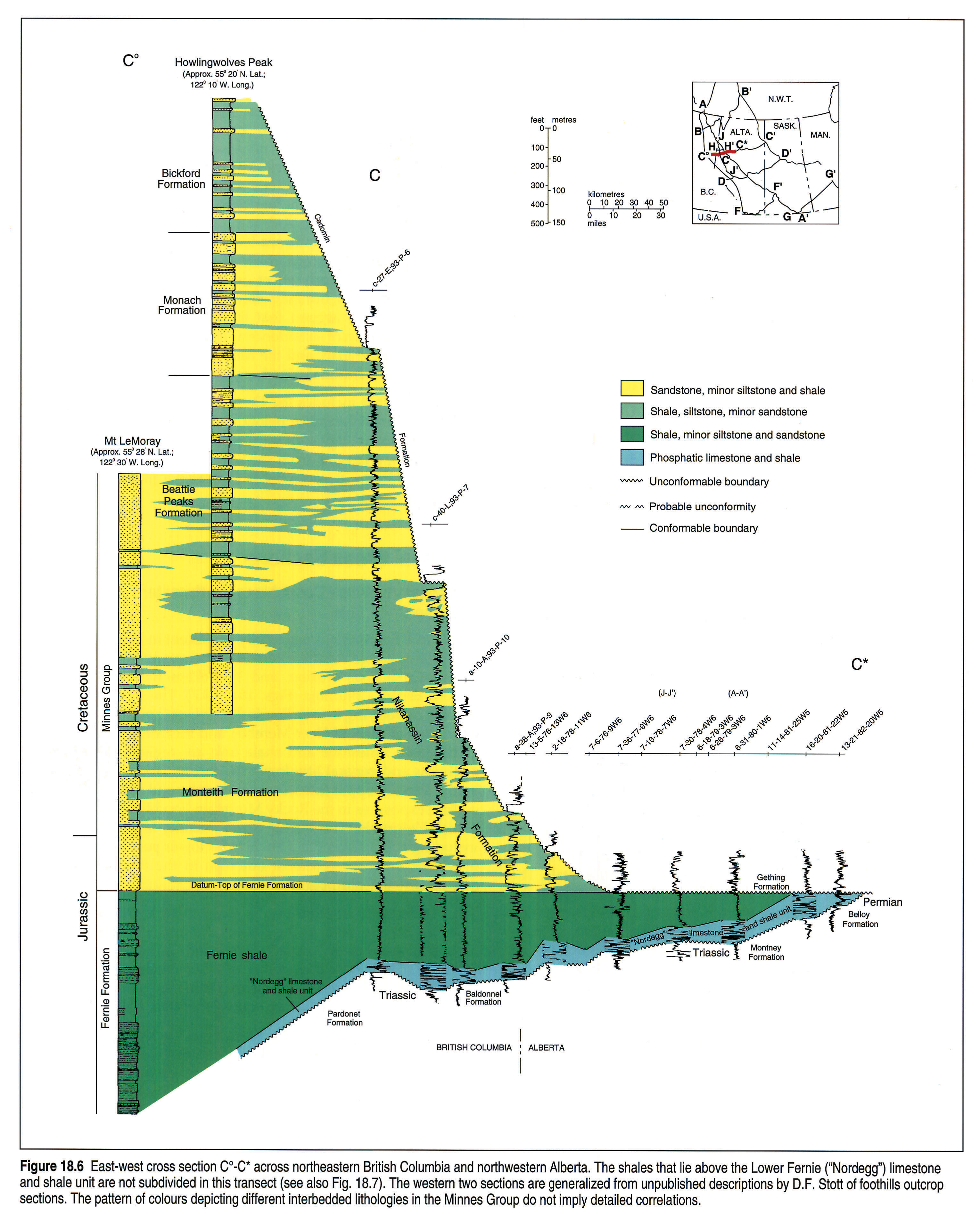
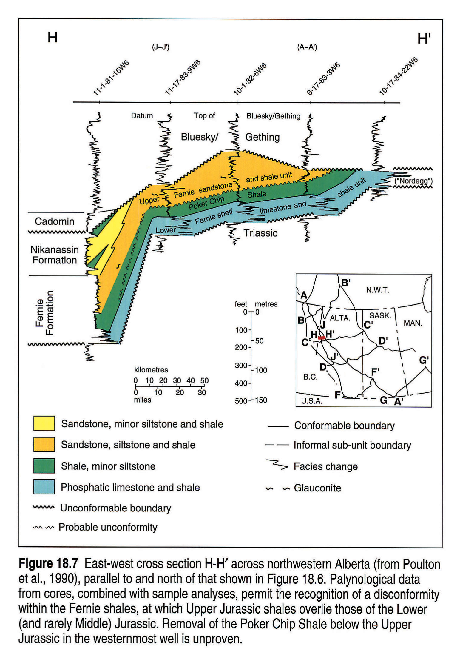
Northeastern British Columbia to Northwestern Alberta: Sections C°-C*, H-H'
The Fernie Formation is essentially consistent in its lithologies and thicknesses across northwestern Alberta, except where truncated by sub-Cretaceous erosion, and it thickens westward in northeastern British Columbia (Figs. 18.6, 18.7). The Poker Chip Shale and the underlying Lower Fernie ("Nordegg": perhaps a northern expansion of the Red Deer Member, and including strata as old as Hettangian) limestone and shale unit are regionally uniform in thickness and general lithology. The former is severely truncated below the sub-Upper Jurassic unconformity and is nearly absent in surface exposures in the Rocky Mountain Foothills of northeastern British Columbia. The 'Fernie Shale', mainly Upper Jurassic but including some Poker Chip Shale in its lower part in some places, is thicker in its westernmost outcrops in the foothills of northeastern British Columbia (Fig. 18.6).
The diachroneity implied by the facies change shown in Figure 18.7 (but not Fig. 18.6) at the base of the uppermost Jurassic and earliest Cretaceous Nikanassin Formation, is not proven by paleontology. The lower formations of the Minnes Group and the more commonly used Nikanassin Formation are lithologically similar surface and subsurface equivalents (Fig. 18.6). The erosion surface below the Cretaceous Cadomin, Gething and lower Mannville formations controls most of the abrupt eastward thinning of the Jurassic. Relief on this surface includes downcutting on either side of the Pembina High (Hayes et al., this volume, Chapter 19), of which the northern extension is characterized by an exceptionally thick Jurassic section (Fig. 18.6).
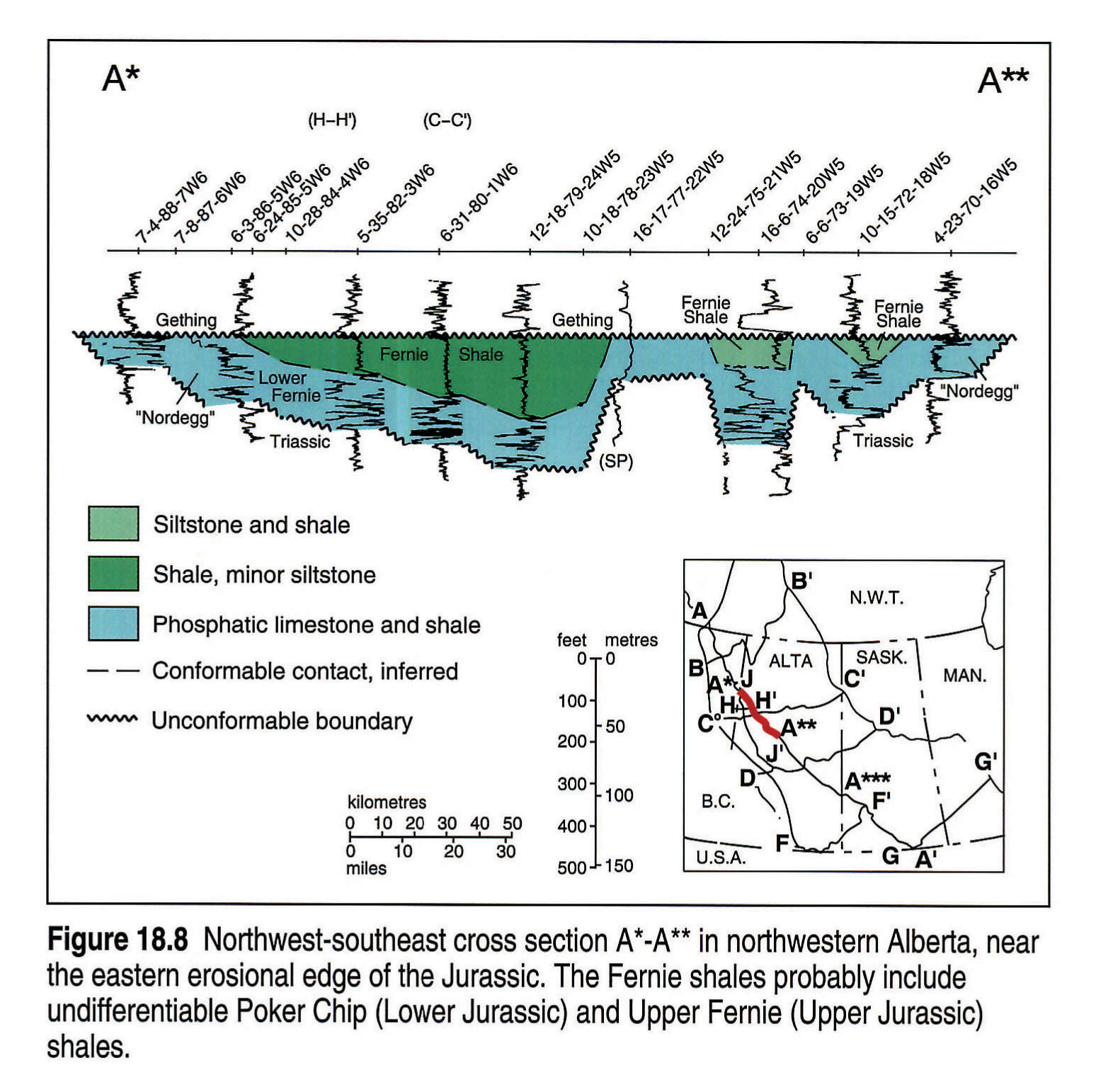
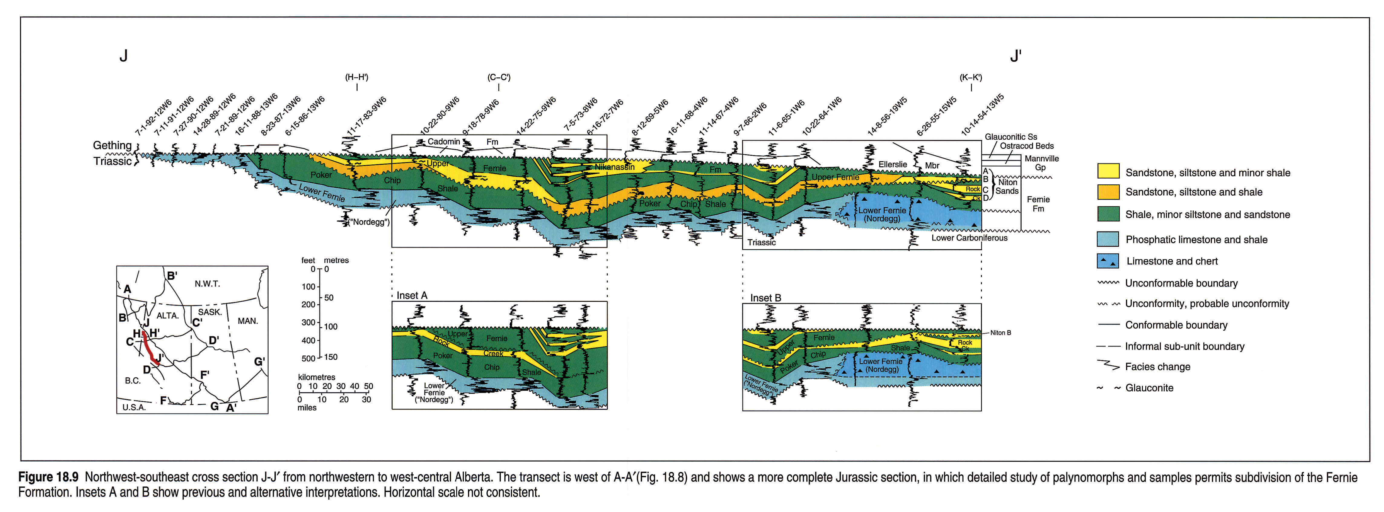
Northwestern to West-central Alberta: Sections A*-A**, J-J'
The eastern cross section (Fig. 18.8) displays the thin Jurassic section near its eastern erosional edge. Stratigraphic relations are better seen in Figure 18.9, which is located farther west.
The platy and highly radioactive Lower Fernie limestones and shales ("Nordegg") are replaced gradually southward, at about Townships 59-60 (54°N latitude), by massive or bedded cherts and limestones of the Nordegg Member proper (Fig. 18.9). The nature of the transition is unclear, but probable differences in ages for the major parts of the two facies assemblages, as well as detailed log correlations around Townships 59-61 (summarized by Poulton et al., 1990, Figs. 4,5), suggest that it is not a simple facies change and that at least one unconformity is involved.
Partly glauconitic and sideritic sandstones and shales in northwestern Alberta are correlated with the Upper Jurassic Niton B sandstone (Fig. 18.9) and rest with probable disconformity upon the Poker Chip Shale (see Poulton et al., 1990). In contrast, Lackie (1958) considered the glauconitic sandstones of the Peace River area to be northward extensions of the (rarely glauconitic) Rock Creek Member (see also Losert, 1986; and Insets A and B of Fig. 18.9).
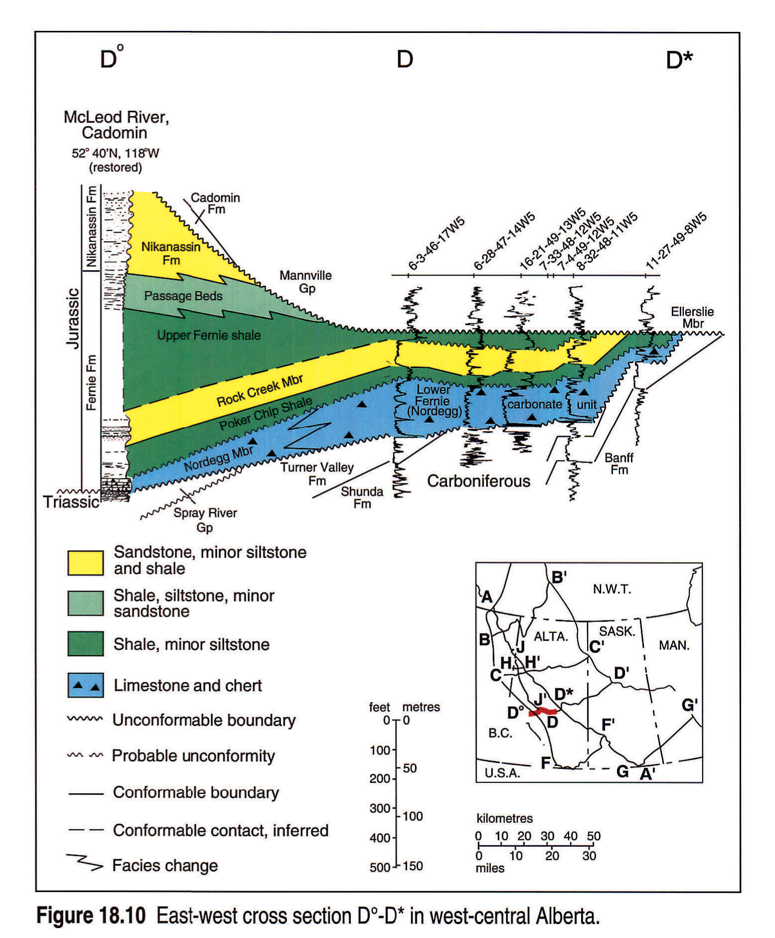
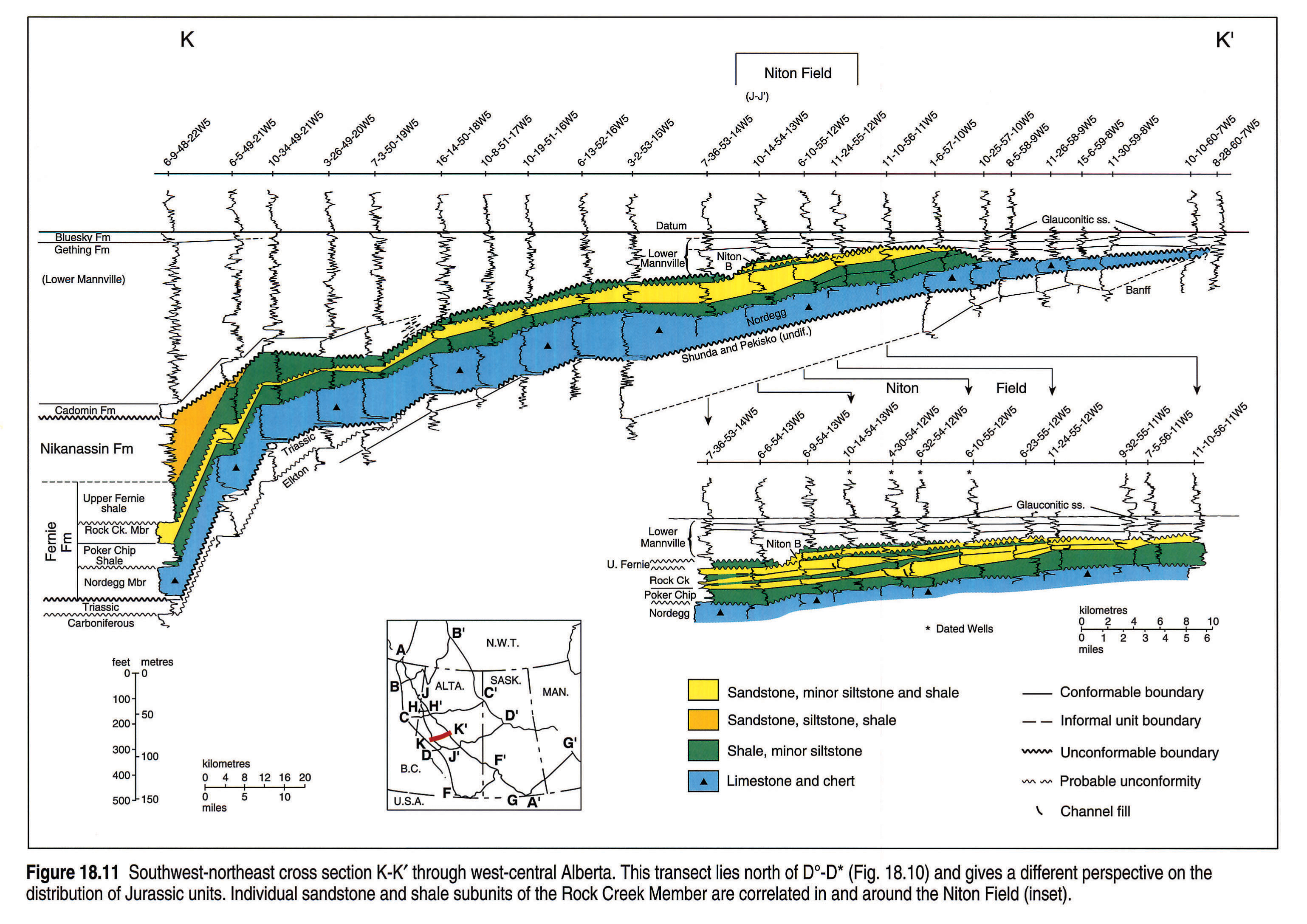
West-central Alberta: Sections Do-D*, K-K'
The general westerly thickening of the Jurassic and lowest Cretaceous package in west-central Alberta (Figs. 18.10, 18.11) is accomplished primarily by greater preservation of the upper units of the Fernie Formation and the Nikanassin Formation below the sub-Cadomin unconformity.
In the subsurface, the Nordegg carbonate bank facies passes westward into the typical black, well-bedded facies of the Nordegg Member in foothills outcrops. The western Nordegg facies contain evidence of slope deposition at some localities, and themselves disappear westward, where the lowest Jurassic interval is dominated by platy limestones of the younger Red Deer Member (Fig. 18.12). The replacement westward of the Nordegg by the younger Red Deer Member provides an important analogue for relations between similar lithological units in west-central and northwestern Alberta (Fig. 18.9). The eastern Nordegg carbonate facies grades eastward into nearshore dolomite and phosphatic sandstone facies (Bovell, 1979).
The Niton B is a local sandstone component of the thin, eastern platform equivalents of the thick Upper Jurassic and lowest Cretaceous foreland trough sequence. Its palynologically determined age attests to the presence of a sub-Upper Jurassic unconformity in this area (Fig. 18.11; Losert, 1990). Erosion below the Mannville Group controls the distribution of each Jurassic unit.
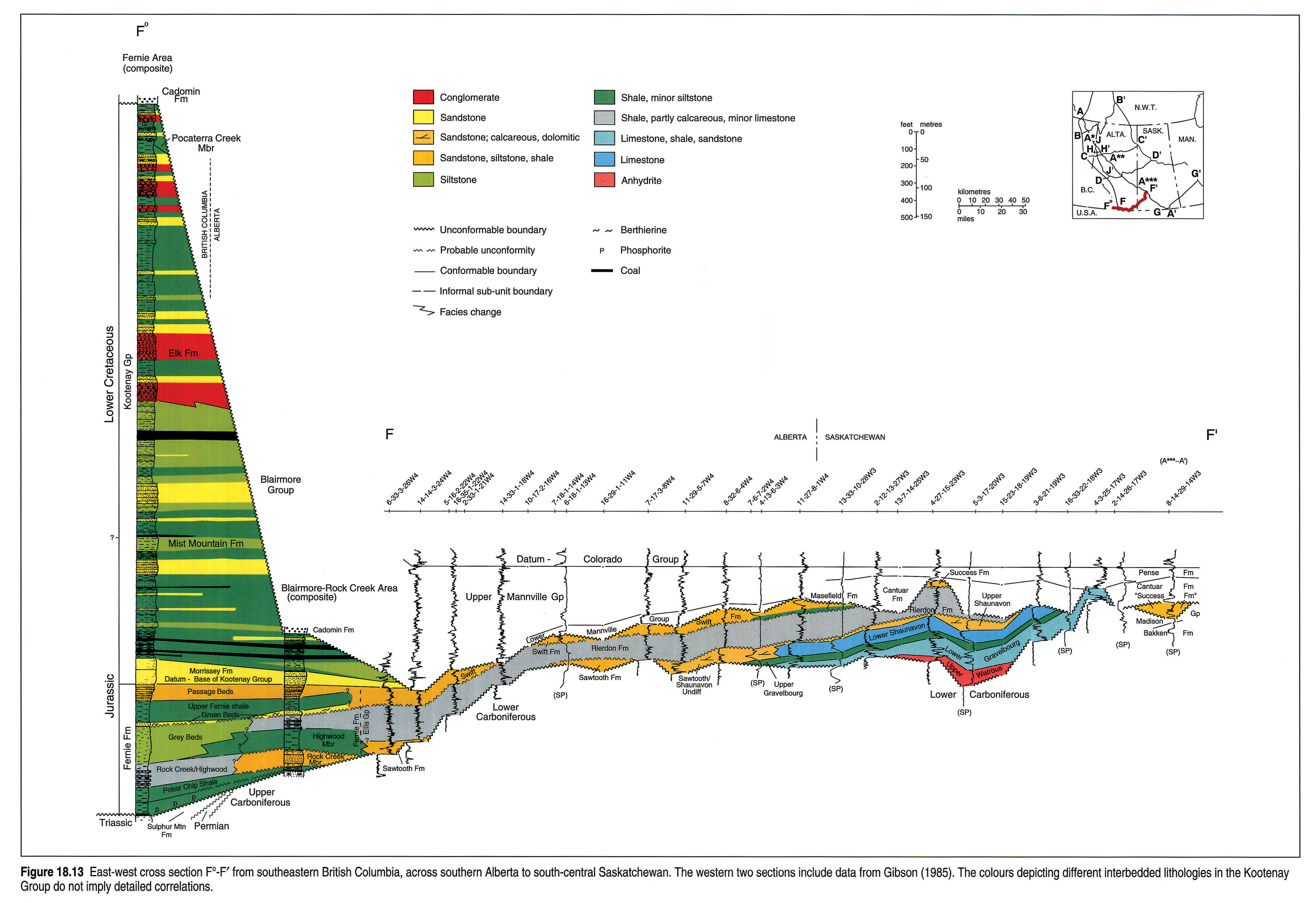
Southeastern British Columbia to Southern Alberta: Section F°-F'
The Lower Jurassic was overlapped eastward in the plains, such that Middle Jurassic strata overlie Paleozoic rocks on the Sweetgrass Arch in south-central Alberta (Fig. 18.13).
The Middle Jurassic formations of southeastern Alberta make up the thin western wedge of the Williston Basin succession, which progressively transgressed the Sweetgrass Arch toward the west. In southwestern Alberta, their slightly thicker equivalents form the middle part of the Fernie Formation. The Jurassic units over the Sweetgrass Arch are unconformity bounded, and some were eroded during and following the Jurassic, to the extent that they form outliers over the crest.
The Kootenay Group is abruptly truncated eastward by erosion below the Cadomin Formation (Blairmore Group). Thin equivalents of the Upper Fernie and lower Kootenay are preserved below the Mannville over the Sweetgrass Arch (Swift Formation; Hayes, 1983), and thicken eastward into the Williston Basin where they contain the major unconformity (below or within the Success Formation) that defines the termination of Williston Basin as a Jurassic depocentre. The generally assumed western source and diachroneity of the Upper Jurassic and lowest Cretaceous orogenic foreland trough fill, shown schematically in Figure 18.3 (but not in Fig. 18.13) are not proven. Paleocurrent data indicate northerly transport directions (e.g., Hamblin and Walker, 1979; Poulton, 1984), implying northward basin-axial filling of the foreland trough.
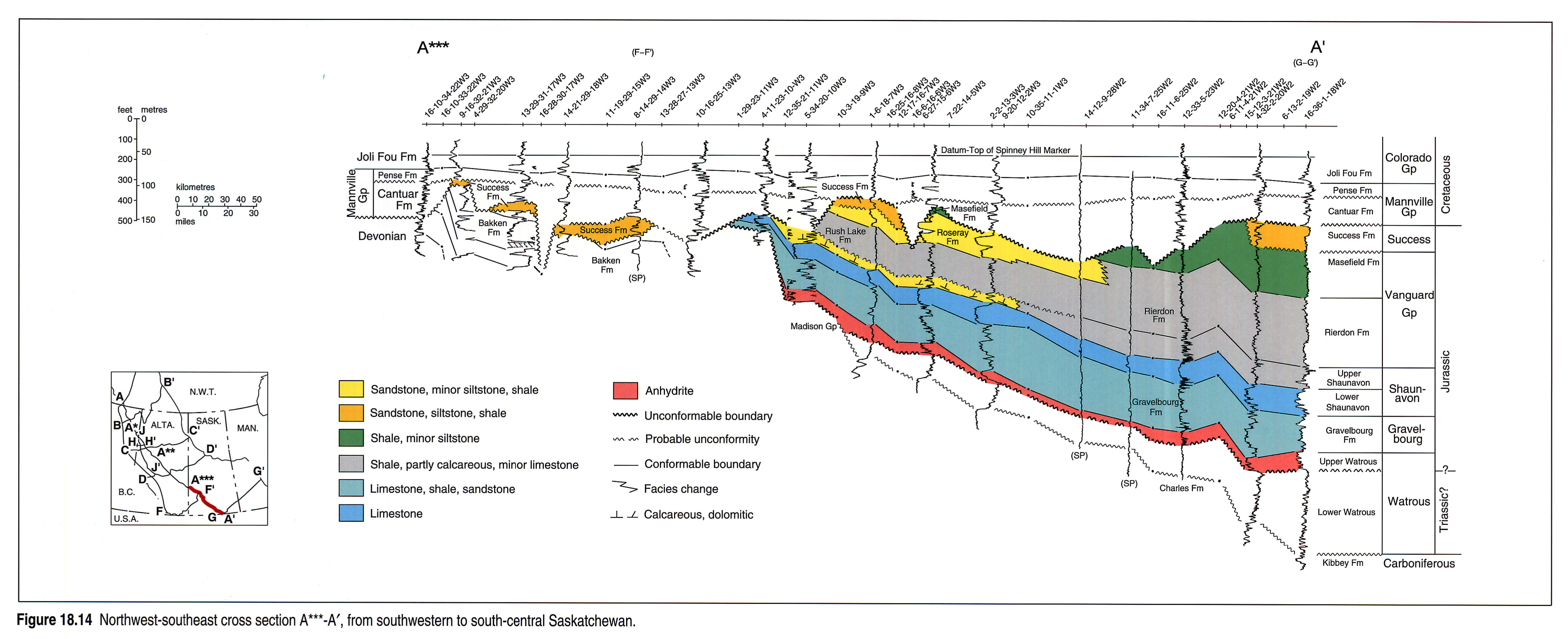
Southwestern Saskatchewan: Sections F°-F', A***-A'
The Jurassic formations of southwestern Saskatchewan (Fig. 18.13) are thin representatives of the Williston Basin succession deposited on the stable Swift Current Platform that lay northwest of the basin centre. Overlap of each of the Middle Jurassic formations by the overlying one, over an irregular depositional surface, characterizes the northwestern and western margins of the basin. Some irregularities in the thickness and distribution of Middle and Upper Jurassic strata are the result of solution of underlying Paleozoic salts, which not only created relief on the sub-Jurassic surface, but also caused local subsidence during the Jurassic (see distribution of Success Formation and basal Mannville surface at western edge of Fig. 18.14).
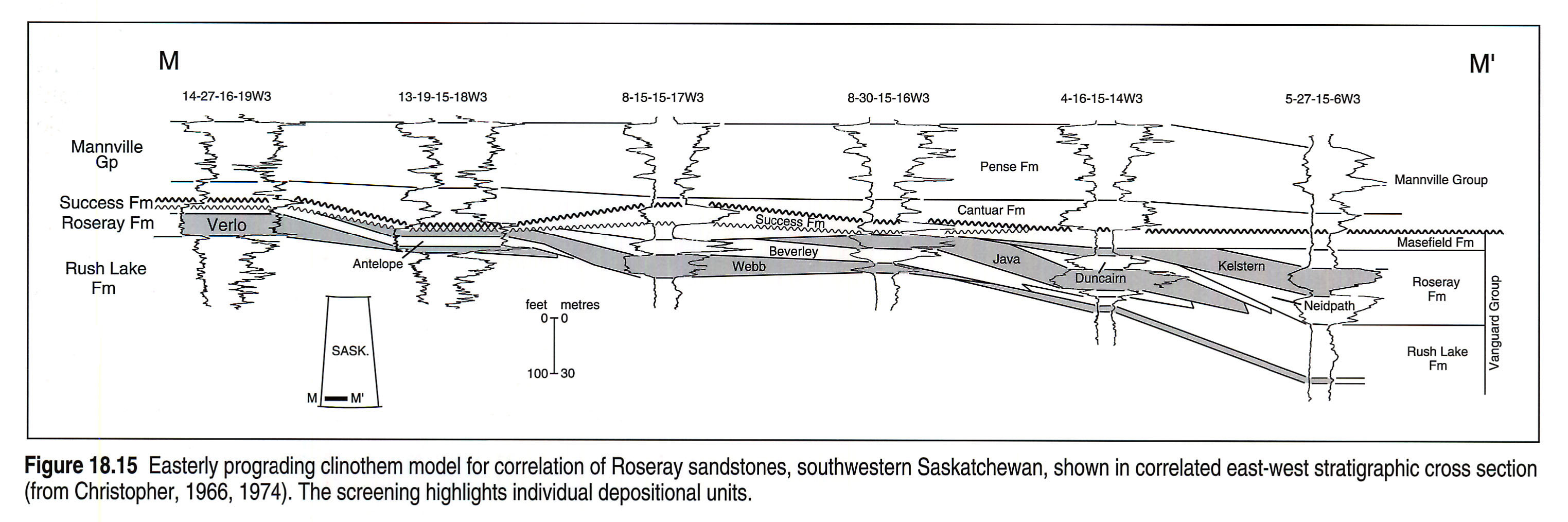
The Roseray sandstone wedge comprises a series of clinothems prograding east from a cratonic source at the northwest margin of Williston Basin. Log correlation of individual clinothem units into north-central Williston Basin (Fig. 18.15) suggests deposition of basinal Rierdon shales in water as deep as 100 m (Christopher, 1966; 1974). The Jurassic and older formations on the northwestern margin of Williston Basin have been eroded, first at the unconformity below the Success Formation, which was deposited beyond the basin limits, and then at the irregular sub-Mannville unconformity (Fig. 18.14).
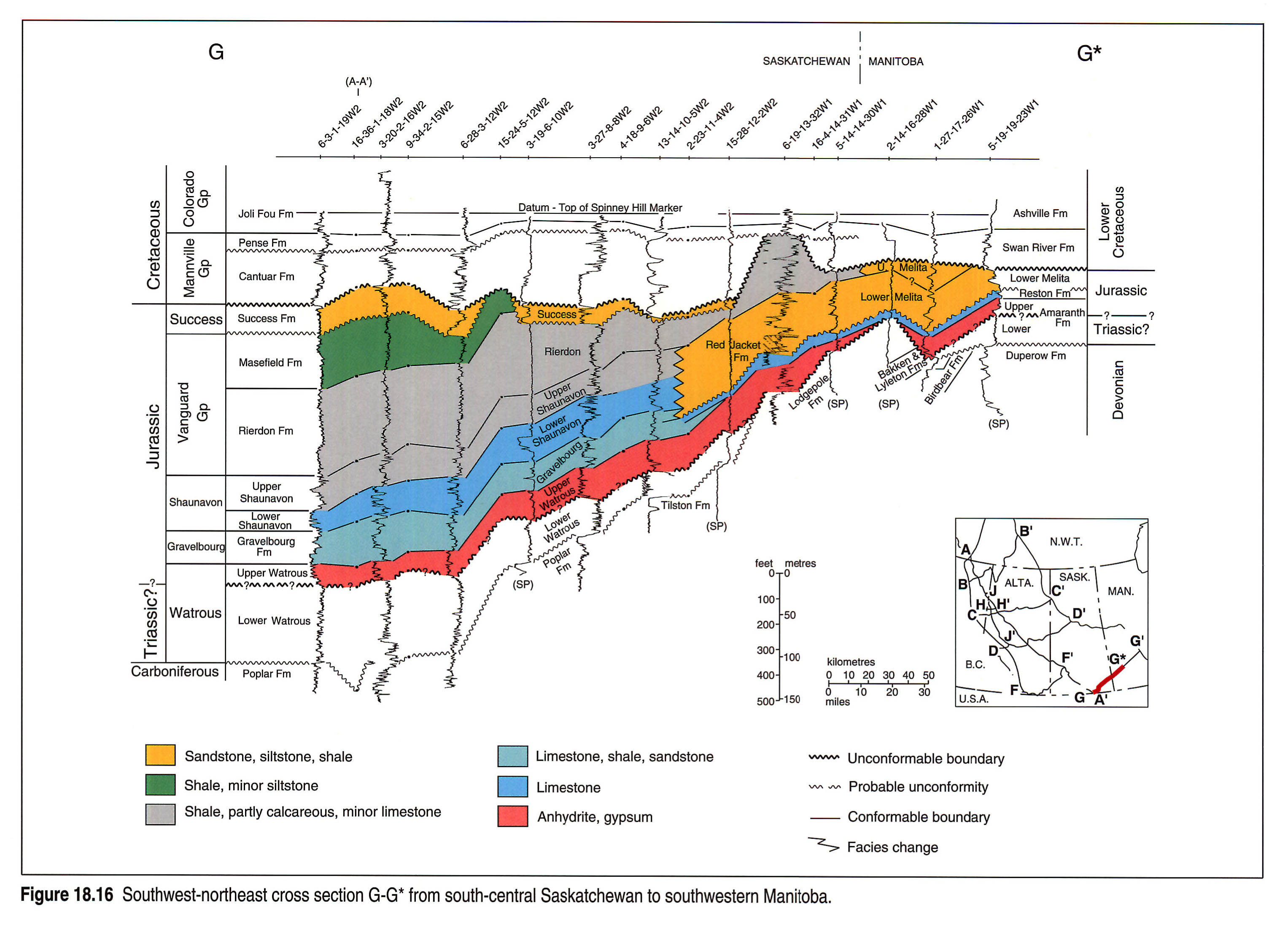
Southeastern Saskatchewan to Manitoba: section G-G*
The upper part of the Watrous Formation, perhaps the lowest Jurassic unit in Williston Basin, overlaps the Triassic(?) lower Watrous onto the northern margin of Williston Basin (Fig. 18.16). The Shaunavon and upper Gravelbourg formations change facies eastward in southern Saskatchewan into the thick Red Jacket sandstones and shales that were probably derived from cratonic highlands to the northeast (Kreis, 1988, 1991). The Birdtail-Waskada topographic high near the Saskatchewan-Manitoba border was transgressed by the Reston limestone at the latitude of cross section G-G*, and by the Melita Formation farther north, where the Reston has pinched out.
The irregular unconformable surface below the Success Formation in southeastern Saskatchewan cuts increasingly deeper within the Vanguard Group toward the northeast basin margin, as does the younger, even more irregular, sub-Mannville surface, limiting the eastern distribution of Jurassic rocks.
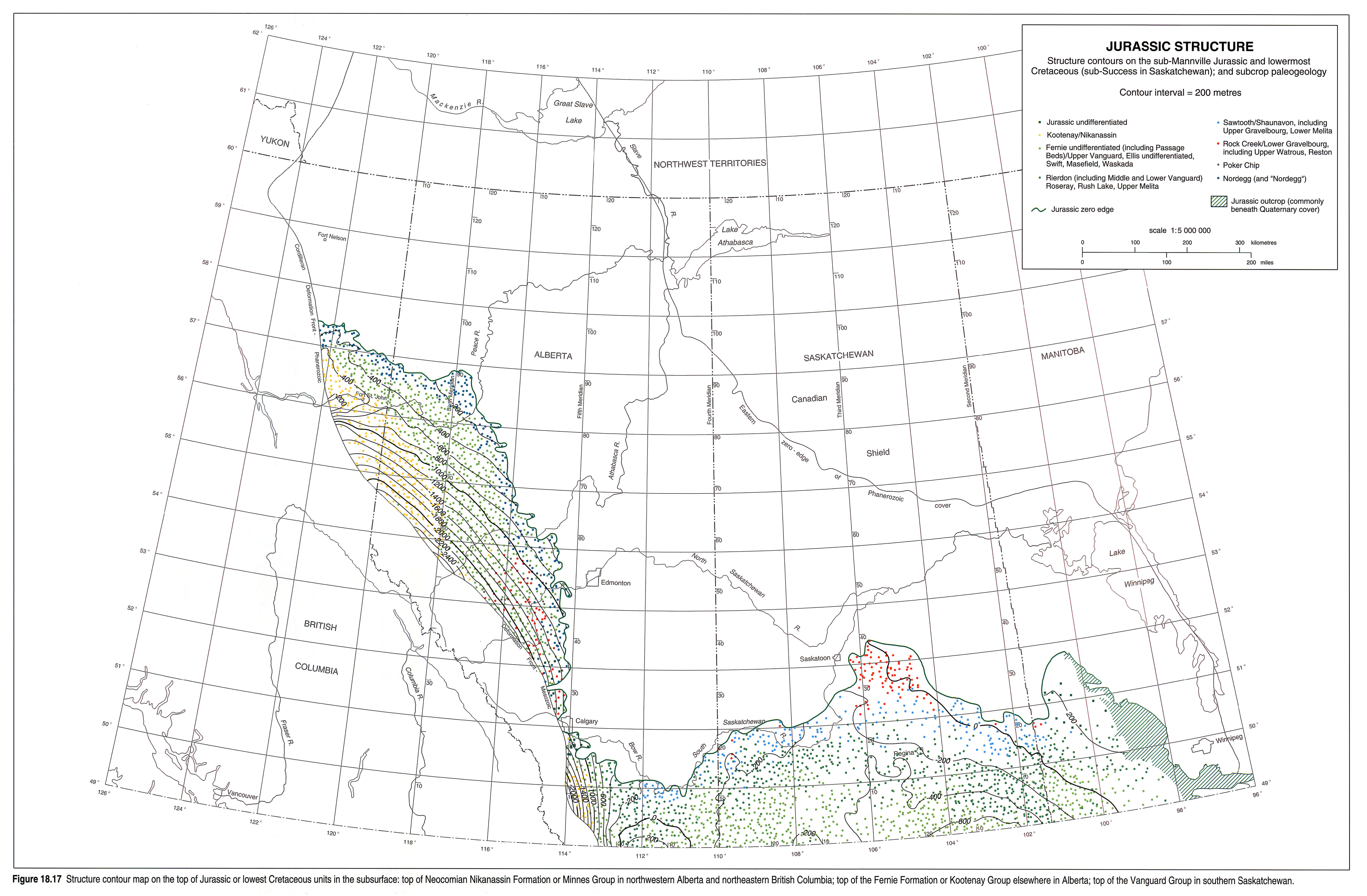
Structure
The upper surface of the Jurassic and lowest Cretaceous package in west-central and northwestern Alberta and northeastern British Columbia dips generally southwest in the undeformed subsurface (Fig. 18.17). A major deviation in northeastern British Columbia may relate to the north-northwestern extension of the sub-Mannville Pembina High. The smooth surface depicted in Figure 18.17is a generalization of what is an extensively channelled erosional surface, with local relief of as much as 150 m (Williams, 1963). This 'sub-Mannville' surface lies below the Deville Formation in Alberta, which is broadly distributed across the erosional limits of older units and controlled by pre-existing topographic lows. Thus a younger age limit of Barremian is given for the major erosional events, if the Deville is Barremian, as suggested by Burden (1984).
The eastern and northern limits of the sub-Deville Jurassic strata are highly irregular on a small scale, partly as a result of valley formation prior to deposition of the Cretaceous Cadomin, Gething and Mannville strata. In west-central Alberta, west of Edmonton and Red Deer, different Fernie members underlie the Cretaceous in a highly irregular pattern, indicative in part of sub-Cretaceous downcutting through the thin Jurassic units present there.
The westward slope of the top of the Jurassic and lowest Cretaceous package is steeper in the subsurface in southwestern Alberta than it is in northeastern British Columbia. The Sweetgrass Arch is well expressed below the Mannville Group in south-central Alberta.
The irregularity of the northern edges of the sub-Success Jurassic strata of the Sweetgrass Arch and Williston Basin (Fig. 18.17) reflects both sub-Success and sub-Mannville erosional patterns, as does the distribution of the Watrous east of Saskatoon. Relief approaching 100 m characterizes the sub-Mannville surface in Saskatchewan and southwestern Manitoba. The top of the Jurassic in southeastern Saskatchewan dips gently toward the centre of Williston Basin, perhaps partly as a result of compaction of the basinal sediments after cessation of differential subsidence, and partly because of Late Cretaceous and Tertiary tectonics. Swift Current Dome in southwestern Saskatchewan is a minor Late Cretaceous or Tertiary positive feature expressed on the top of the Jurassic.
Thickness and Lithology
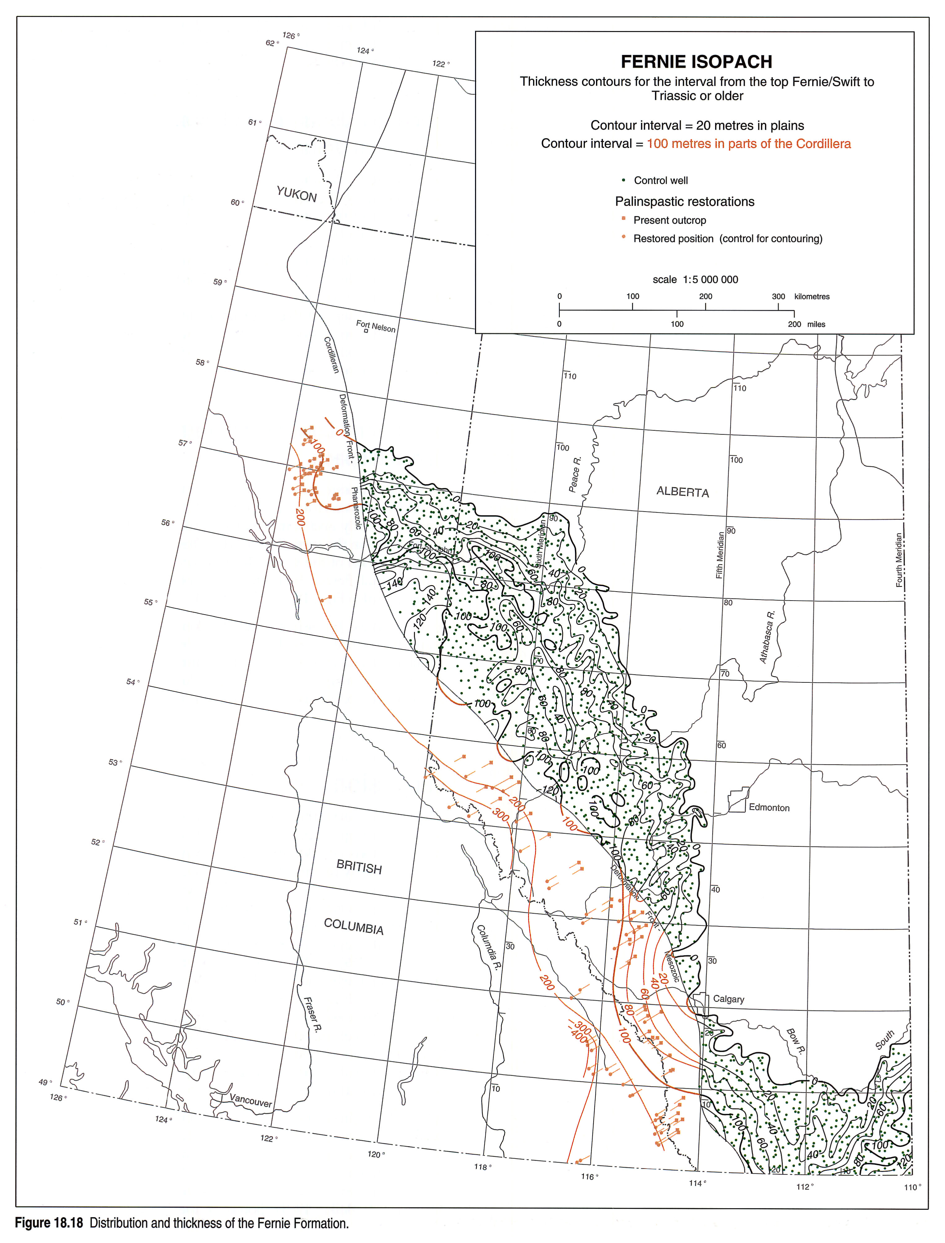
Fernie Formation
Figure 18.18 shows the thickness and distribution of the entire Fernie Formation and its equivalents in southern Alberta. It thickens gently and irregularly west-southwestward in west-central and northwestern Alberta and northeastern British Columbia. The Fernie is relatively thick (100 m) along the axis of the highland that constitutes a north-northwest extension of the Pembina High. The eastern and northern limits of the Fernie, controlled by erosion below the Cadomin, Gething and Mannville, are highly irregular in detail, involving in places a dissected escarpment with small outliers of Jurassic units beyond it.
Lower Jurassic Units
Lower Fernie Strata
Pliensbachian and older Jurassic strata (see Fig. 18.4) are preserved in both the subsurface and outcrop in west-central to northwestern Alberta and northeastern British Columbia (Fig. 18.19), but are recognizable only in outcrop farther south. North of about 54°N latitude, the Lower Fernie ("Nordegg") thins gradually westward from a subtle north-northwest-elongated depocentre in which it reaches 40 m in thickness. More abrupt eastward thinning is largely, if not entirely, related to sub-Cretaceous erosion. The Lower Fernie strata reach 60 m in thickness in outcrops in northeastern British Columbia, where additional strata (Hettangian) appear at their base. South of 54°N latitude, the Nordegg Member exceeds 50 m in thickness west of Edmonton. Its eastward thinning is in part depositional and in part due to subsequent erosion. The Nordegg and Red Deer members together thin to the west, in outcrops in the mountains and foothills (see also Fig. 18.12).
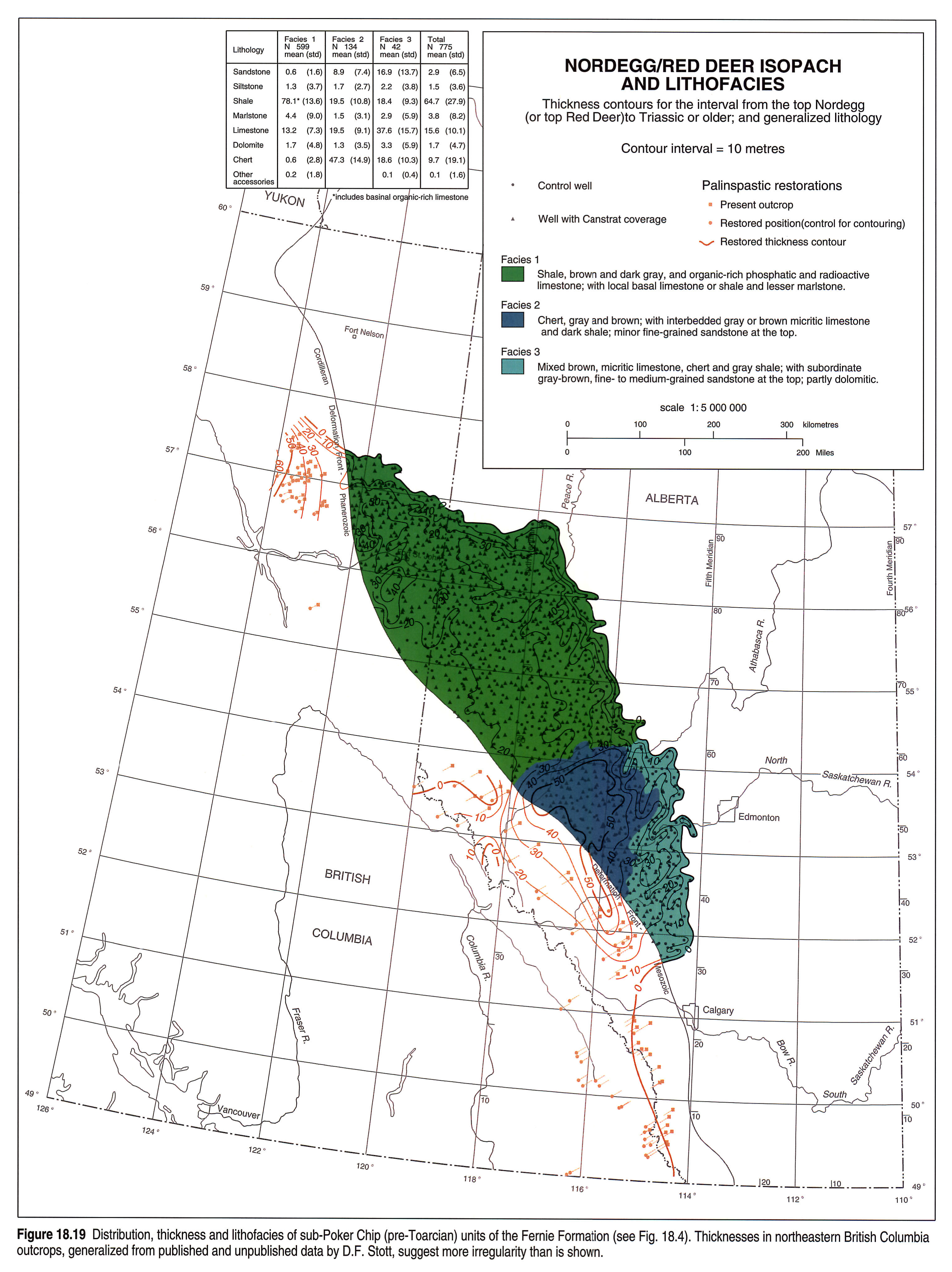
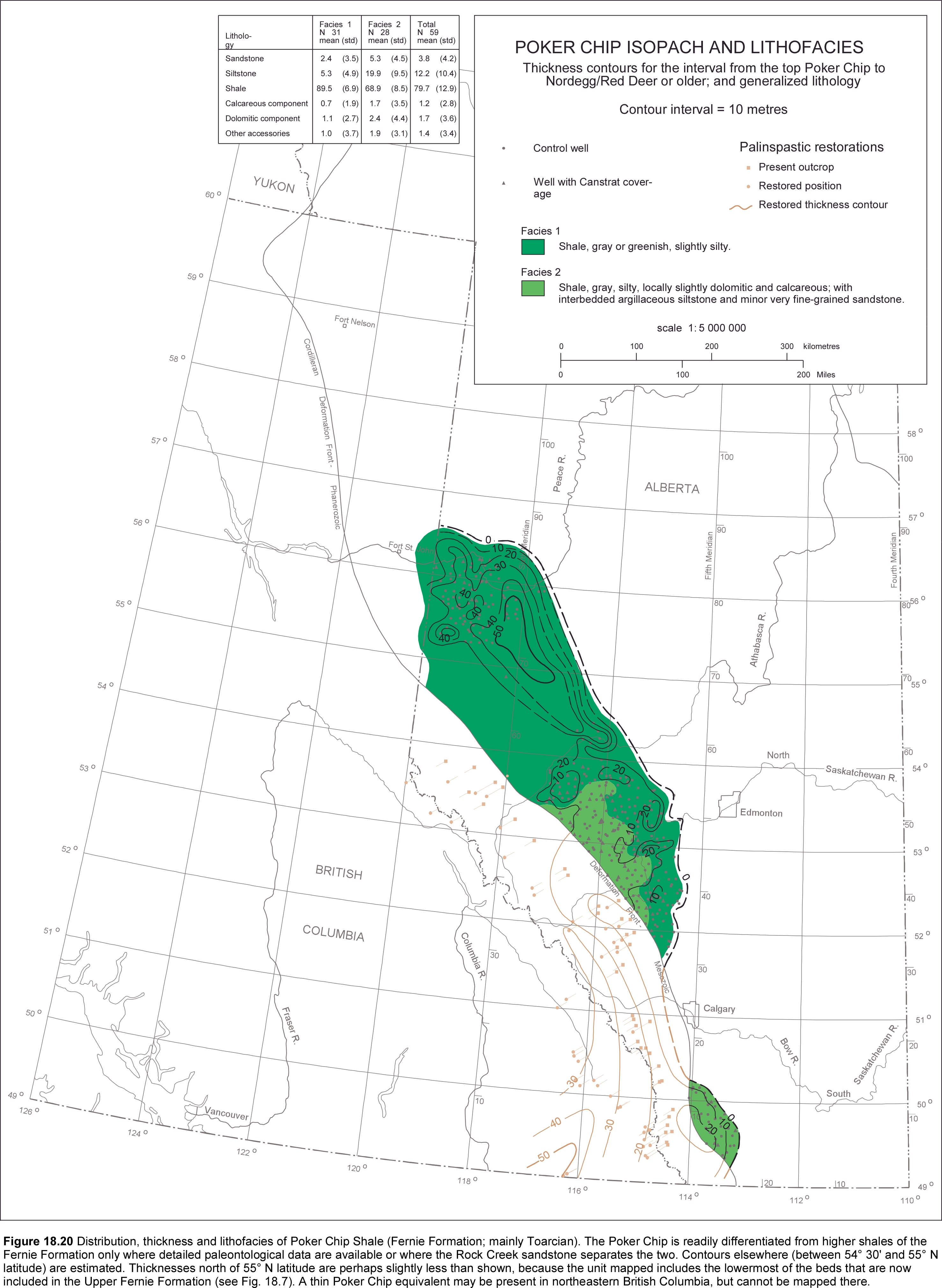
Poker Chip Shale
The Poker Chip Shale member exhibits gradual northward thickening to more than 55 m south of Peace River (Fig. 18.20). Gentle irregularities are due partly to pre-Late Jurassic and Cretaceous erosion and partly to the local inclusion of significant sandstone units of Aalenian age in east-central Alberta in the overlying Rock Creek Member. Westerly thickening to more than 50 m is suggested by the outcrop data, perhaps partly related to westward shaling out of underlying carbonates and overlying sandstones. The siltstone-rich rocks west of Edmonton (Fig. 18.20, Facies 2) are probably western equivalents of the sandstones assigned to the lower Rock Creek Member to their east.
Lowermost Middle Jurassic Units
Lower Bajocian strata (Fig. 18.21) are apparently absent in northwestern Alberta, and what had been reported previously as Rock Creek sandstone (Lackie, 1958) has been reassigned to the Upper Jurassic (Poulton et al., 1990). In west-central Alberta, the multiple Lower Bajocian sandstones and shales in the northern facies area of the Rock Creek Member gradually thicken westward to over 30 m in the subsurface. They are in part equivalent to the lower Highwood shale of southwestern Alberta. Their northern boundary coincides approximately with the northern limit of the underlying Nordegg carbonate facies. Upper parts of the underlying Poker Chip Shale (Figs. 18.4, 18.20) comprise western equivalents of the lower Rock Creek Member west of Edmonton. In the southern facies area, south of Calgary, the single Rock Creek sandstone unit exceeds 10 m in thickness in outcrop. Equivalent strata are absent over Sweetgrass Arch.
The undated, but probably approximately equivalent lower Gravelbourg limestones and shales, Reston limestones and perhaps upper Watrous and upper Amaranth evaporites thicken gradually in southeastern Saskatchewan and southwestern Manitoba toward the centre of Williston Basin, to a maximum of 80 m in Canada (Figs. 18.14, 18.16, 18.21). These units maintain an irregular thickness of between 45 and 70 m across most of southern Saskatchewan. The Birdtail-Waskada axis at the Saskatchewan-Manitoba border, transgressed by the Reston and Melita formations, is well expressed in the isopachs. The occurrence of the Amaranth in the Dominion City Channel and the Lake St. Martin structure (Fig. 18.1) suggests that its eastern depositional limit was far to the east. The western depositional edge of the Lower Bajocian strata against Sweetgrass Arch is overlapped by younger Middle Jurassic beds; the northern edge is controlled by sub-Mannville erosion.
Higher Middle Jurassic Units
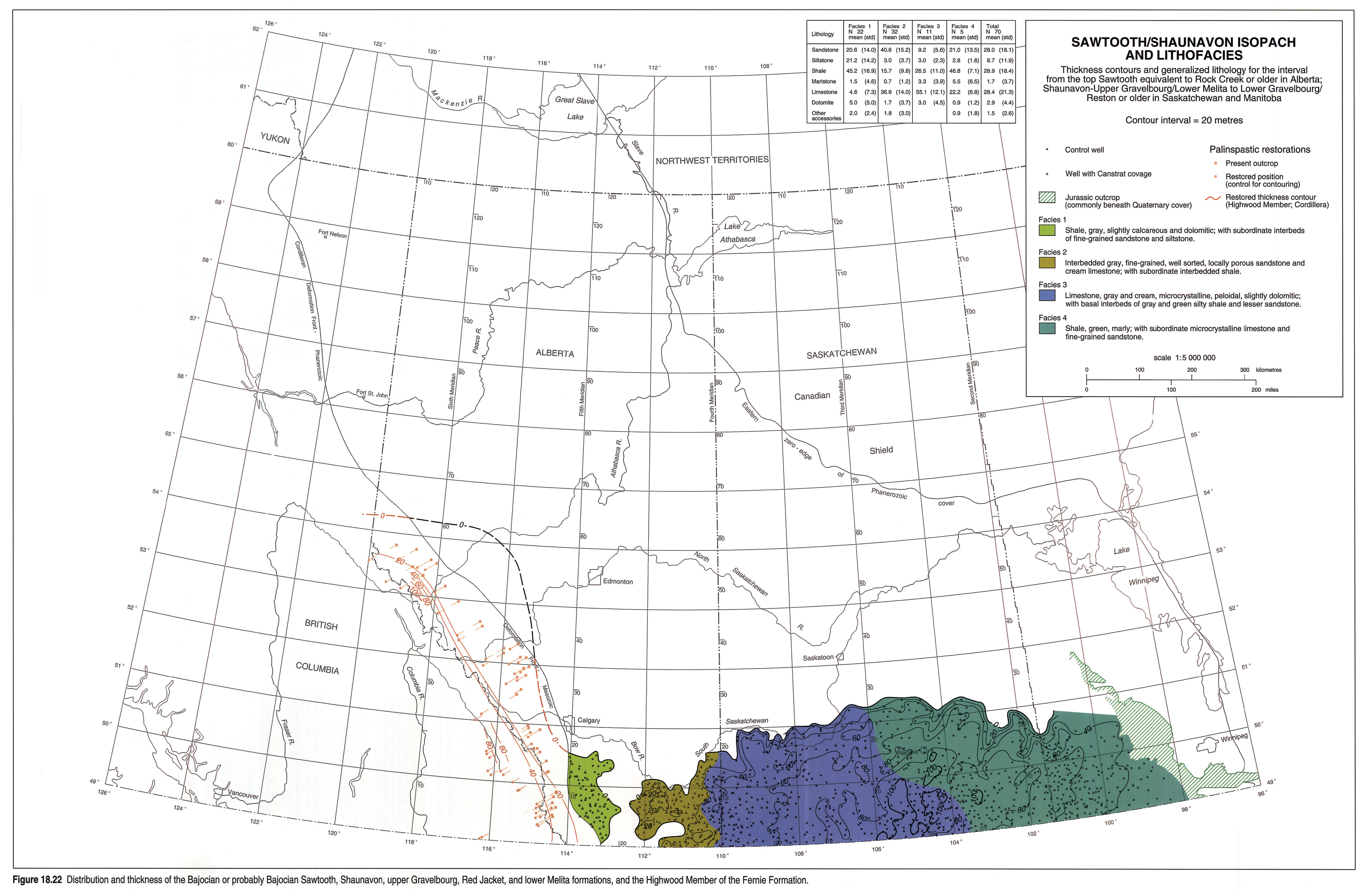
In southwestern Alberta, the Bajocian and Bathonian Sawtooth sandstones on the west flank of Sweetgrass Arch thicken gradually westward (Fig. 18.22) into primarily shale and siltstone strata of the Fernie Formation (Figs. 18.4, 18.13, 18.18), that extend in outcrop as far north as 54°N latitude. Toward the east, equivalent strata are thin and erratically preserved on the crest of Sweetgrass Arch in southeastern Alberta. The limits of the Sawtooth on either side of Sweetgrass Arch indicate deposition against paleotopographic highs. The Shaunavon and upper Gravelbourg limestones, sandstones and shales thicken gently and irregularly toward a series of localized small depocentres in south-central Saskatchewan, where they reach nearly 110 m in thickness. The northeastern basin-marginal equivalent in southeastern Saskatchewan (Red Jacket sandstone and shale) thins eastward into the lower Melita in southern Manitoba. The northern edge of the Shaunavon is controlled by pre-Late Jurassic or pre-Cretaceous erosion.
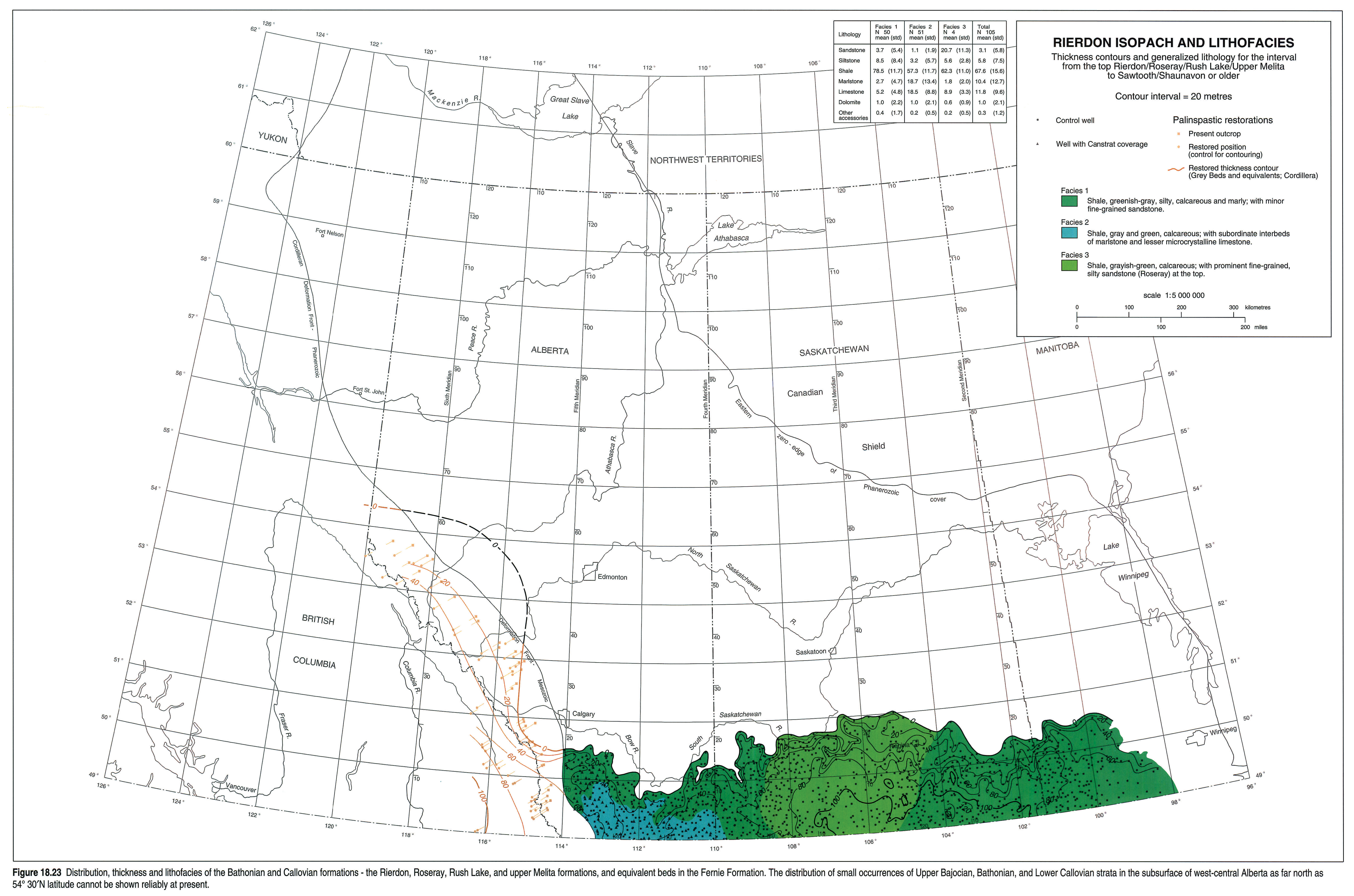
The Bathonian and Callovian Rierdon shale in southern Alberta thickens southwestward off Sweetgrass Arch (Fig. 18.23) into equivalent and similar beds of the Fernie Formation. The Rierdon and Rush Lake shales in south-central and southeastern Saskatchewan together thicken toward the centre of Williston Basin. The irregular northern limit of the Bathonian and Callovian strata is controlled by sub-Success or sub-Mannville erosion.
Upper Jurassic Units
The Upper Fernie thickens gradually, then abruptly, westward into the foreland trough that formed during the early stages of the Columbian Orogeny (Fig. 18.24). Its thickness and distribution are approximate in the large area northwest of Edmonton because it has not been completely differentiated from the lithologically similar underlying Poker Chip Shale where the intervening Rock Creek sandstone is absent. Its irregular thickness in the undisturbed subsurface is largely controlled by sub-Cadomin or sub-Gething erosion.
The Swift Formation, partly removed by pre-Deville or pre-Mannville erosion over the crest of Sweetgrass Arch in southern Alberta, thickens on the west side of the arch into the Upper Fernie shales (Fig. 18.24). The Masefield shale thickens southward in southeastern Saskatchewan toward the centre of Williston Basin and there is a subsidiary minor depocentre in southwestern Saskatchewan within the Swift Current Platform. The distribution and irregular thicknesses of the Masefield and Waskada shales are controlled by erosion prior to deposition of the Success or Mannville sandstones.
Uppermost Jurassic and Lowermost Cretaceous Units
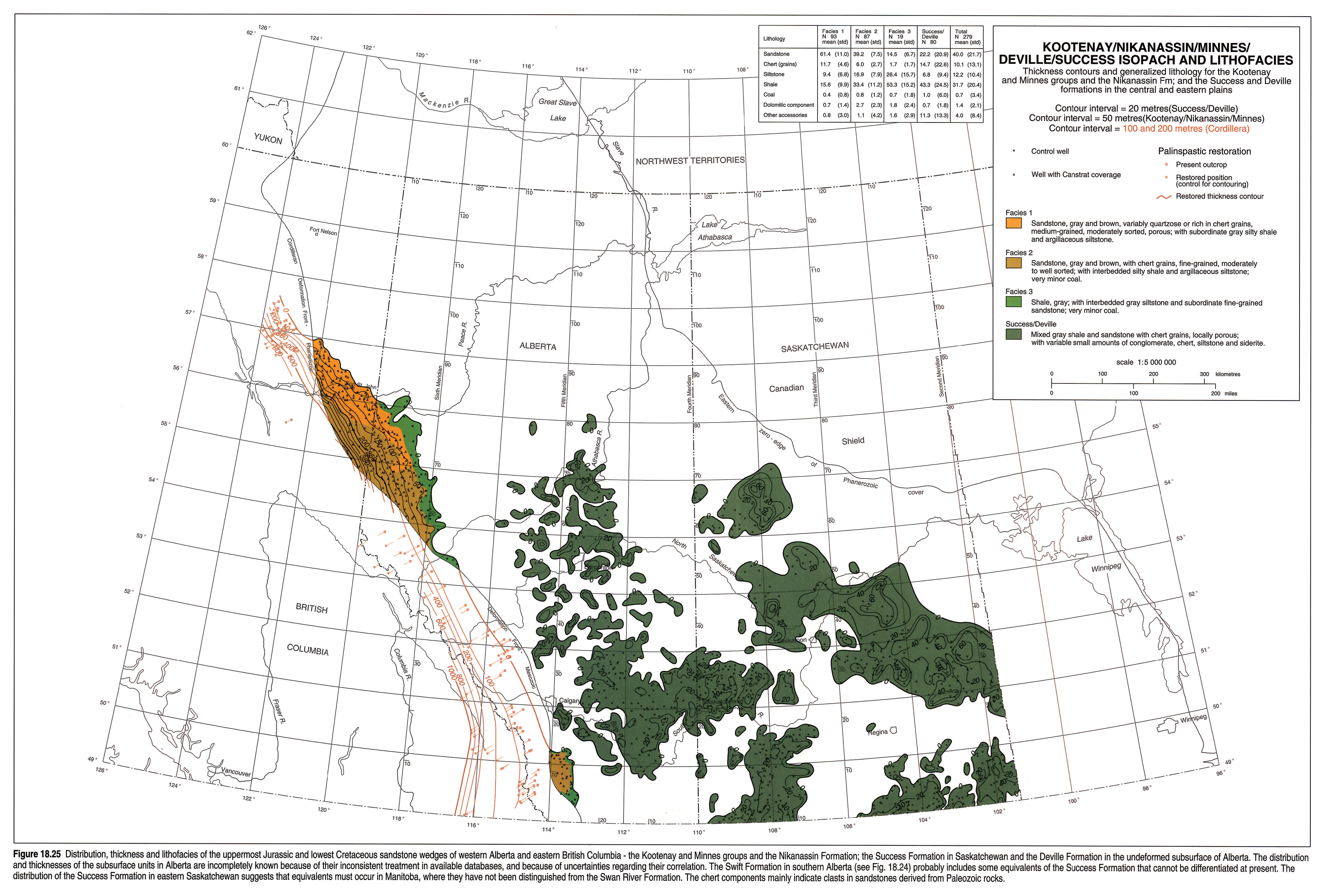
The Nikanassin, Minnes and Kootenay siliciclastics thin rapidly eastward (Fig. 18.25), a result of both depositional thinning away from the axis of the foreland trough and pre-Aptian downcutting in the same direction. The patchy distribution of the Success sandstone in Saskatchewan and of the Deville in Alberta (Fig. 18.25) is consistent with an origin as largely craton-sourced, little-transported detritus deposited on an irregular peneplain that postdates the Late Jurassic manifestations of Williston Basin. Their distribution suggests preservation partly in pre-existing ancient valley systems (e.g., Edmonton Channel; Williams, 1963).
Jurassic and Lowermost Cretaceous Gross Interval Isopach
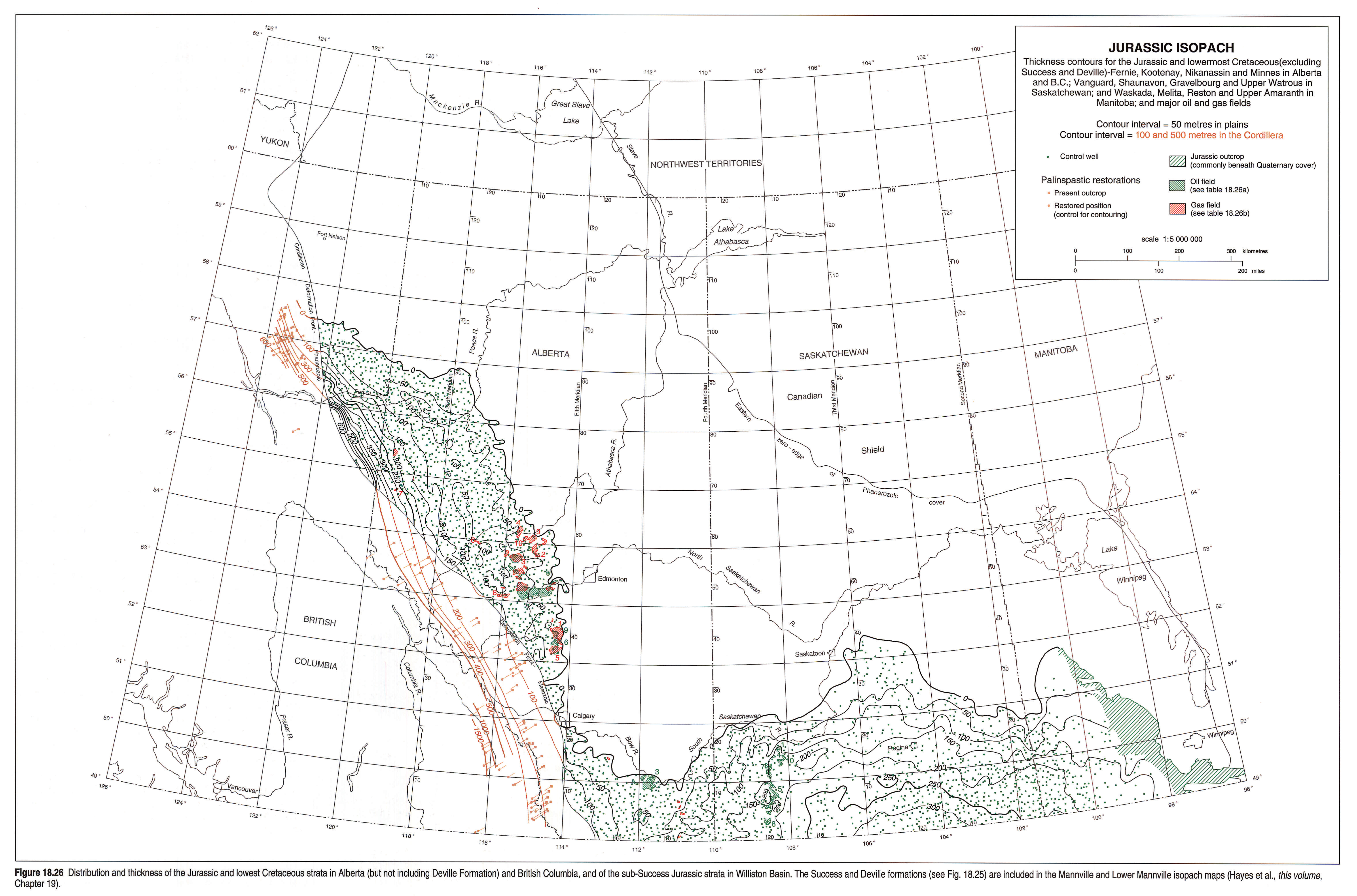
The overall Jurassic and pre-Aptian Cretaceous succession thickens west-southwestward in western Alberta and eastern British Columbia, gently and somewhat irregularly in the east, abruptly and regularly in the west (Fig. 18.26). This pattern is a result of the superimposition of the Upper Jurassic orogenic clastic wedges on the platformal Fernie Formation, and of subsequent pre-Aptian erosion (see also Figs. 18.6, 18.10, 18.13). The sub-Success Jurassic package thickens gently and irregularly toward the centre of Williston Basin. Sweetgrass Arch and the Birdtail-Waskada axis, both relatively inactive during the Jurassic and initially transgressed during the Bajocian or Bathonian, are well expressed on the isopach map (Fig. 18.26).
Discussion
In Western Canada, the Jurassic strata contain the record of eustatic and epeirogenic events in the Early and Middle Jurassic, and of the collisions of allochthonous terranes in the eastern Pacific with the westerly drifting North American continent in the Middle or Late Jurassic. In the Sinemurian (Early Jurassic), phosphorite deposition in what is now southeastern British Columbia and southwestern Alberta indicates the presence of upwelling oceanic currents that suggest access to a deep ocean farther west (Poulton and Aitken, 1989). Only minor, thin bentonite layers indicate volcanism in the Early and Middle Jurassic epicratonic record, which is equivocal with respect to evidence for pre-Late Jurassic tectonic activity in the west. By Late Jurassic time, the region had undergone a reversal of tectonic polarity, as western areas uplifted during early phases of the Columbian Orogeny were eroded. The resulting detritus filled the foreland trough, superposed on the pre-orogenic sedimentary pile.
The Middle Jurassic increase in subsidence rates for the western Canada platform and Williston Basin (and perhaps also Moose River in Ontario and Michigan Basin in Michigan) may be ultimately related to the increase in central Atlantic and Gulf of Mexico spreading rates at about the same time (Vogt and Tucholke, 1986, Plate 1; Bally, 1989). Some of the poorly known Middle Jurassic fine-grained siliciclastic units in the Fernie Formation of southwestern Alberta have been interpreted as westerly sourced, perhaps earliest epicratonic products of the Columbian Orogeny (Poulton, 1988). Similarly, the regional uplift of the Western Canada Sedimentary Basin in the Late Jurassic may have some common causal relation with uplift of western orogenic source terranes and the subsidence of the orogenic foreland trough.
Overall northward drift of the continent during the Jurassic, as indicated by paleomagnetic data (e.g., May and Butler, 1986) may have moved its western margin out of the depositional zone of, first phosphorites, then carbonates, accounting for their loss upward in the Jurassic column and northward in the western Canadian epicratonic basins. The predominance in Upper Jurassic strata of boreal molluscs, such as cardioceratid ammonites and the bivalve Buchia, as compared with the East Pacific and other generally southern ammonites in the Lower and Middle Jurassic, conforms with such movement.
Increased precipitation throughout the Jurassic period in Western Canada is also suggested by the lithologies of the Jurassic strata. Arid or semi-arid conditions indicated by evaporites (and redbeds if those in Williston Basin are of Early or early Middle Jurassic rather than Triassic in age) give way to the humid coal-forming swamp conditions of the Late Jurassic. Such an increase in precipitation might be expected with the change in wind patterns and physiography associated with both uplift of a major orogenic belt to the west, and northward transport of the region.
There may be a concomitant increase in the quantity of storm, as opposed to tidal, activity from the Middle to the Upper Jurassic succession, suggested by the sedimentary structures of the respective sandstones.
Acknowledgements
Cathy Szata assisted in correlations in Alberta and the preparation of figures early in the project. Information, advice, and unpublished cross sections of the Jurassic in specific areas were freely offered by Don Stott, Lorne Rosenthal and Shaun O'Connell. This chapter incorporates new biostratigraphic data, available through recent unpublished studies by Elliot Burden, Ed Davies, and Graham Dolby. Certain ideas have benefitted from discussions with Eric Albrechtsons, Indranil Banerjee, Graham Davies, Paul Johnston, John Kramers, Dave McIntyre, Margot McMechan, Suzan Moore, Peter Putnam, Cindy Riediger, Dave Smith, Roy Smith, Art Sweet, and Rick Young. Dave Gibson, Rick Young, and an anonymous reviewer critically reviewed this manuscript.
References
- Badgley, P.C. 1952. Notes on the subsurface stratigraphy and oil and gas geology of the Lower Cretaceous series in central Alberta. Geological Survey of Canada, Paper 52-11.
- Bally, A.W. 1989. Phanerozoic basins of North America. In: The Geology of North America; An Overview. A.W. Bally and A.R. Palmer, (eds.). The Geology of North America (DNAG), vol. A. Geological Society of America, p. 397-446.
- Banerjee, I. 1990. Some aspects of Lower Mannville sedimentation in southeastern Alberta. Geological Survey of Canada, Paper 90-11.
- Bovell, G.R.L. 1979. Sedimentation and diagenesis of the Nordegg Member in central Alberta. Unpublished M.Sc. thesis, Queen's University, Kingston, Ontario, 188 p.
- Burden, E.T. 1984. Terrestrial palynomorph biostratigraphy of the lower part of the Mannville Group (Lower Cretaceous), Alberta and Montana. In: The Mesozoic of Middle North America. D.F. Stott and D. Glass (eds.). Calgary, Canadian Society of Petroleum Geologists, Memoir 9, p. 249-270.
- Butrenchuk, S.B. 1987. Phosphate in southeastern British Columbia (82G and 82J). Province of British Columbia, Ministry of Energy, Mines and Petroleum Resources, Mineral Resources Division, Geological Survey Branch, Open File 1987-16.
- Christie, R.L. 1989. Jurassic phosphorite of the Fernie synclinorium, southeastern British Columbia, Canada. In: Phosphate deposits of the world, Volume 2. Phosphate rock resources. A.J.G. Nothold, R.P. Sheldon and D.F. Davidson (eds.). Cambridge University Press, New York, p. 79-83.
- Christopher, J.E. 1964. The Middle Jurassic Shaunavon Formation of southwestern Saskatchewan. Saskatchewan Department of Mineral Resources, Report no. 95, 95 p.
- Christopher, J.E. 1966. Shaunavon (Middle Jurassic) sedimentation and vertical tectonics in southwestern Saskatchewan. Billings Geological Society Guidebook. 17th Annual Field Conference, p. 18-35.
- Christopher, J.E. 1974. The Upper Jurassic Vanguard and Lower Cretaceous Mannville Groups of southwestern Saskatchewan. Saskatchewan Department of Mineral Resources, Report no. 151, 349 p.
- Christopher, J.E. 1984. Stratigraphic and tectonic setting of the Lower Cretaceous Mannville Group, northern Williston Basin region, Canada. In: The Mesozoic of Middle North America. D.F. Stott and D. Glass (eds.). Calgary, Canadian Society of Canadian Petroleum Geologists, Memoir 9, p. 109-126.
- Christopher, J.E. 1988. Note on an Upper Jurassic section in southeastern Saskatchewan and its relationship to adjacent regions. In: Summary of Investigations 1988. Saskatchewan Geological Survey, Miscellaneous Report 88-4, p. 196-201.
- Corkery, M.T. 1987. Geological Highway map of Manitoba. M.T. Corkery (Chairman) and others (Map Committee). Geological Survey of Canada and Manitoba Minerals Division, M.D.A. Special Publication No. 1.
- Creaney, S., Allan, J., Cole, K.S., Fowler, M.G., Brooks, P.W., Osadetz, K.G., Macqueen, R.W., Snowdon, L.R., and Riediger, C.L. (this volume). Petroleum generation and migration in the Western Canada Sedimentary Basin. In: Geological Atlas of the Western Canada Sedimentary Basin. G.D. Mossop and I. Shetsen (comps.). Calgary, Canadian Society of Petroleum Geologists and Alberta Research Council, chpt. 31.
- Dow, W.G. 1967. The Spearfish Formation in the Williston Basin of western North Dakota. North Dakota Geological Survey, Bulletin 52, 17 maps.
- Edwards, D.E., Barclay, J.E., Gibson, D.W., Kvill, G.E., and Halton, E. (this volume). Triassic strata of the Western Canada Sedimentary Basin. In: Geological Atlas of the Western Canada Sedimentary Basin. G.D. Mossop and I. Shetsen (comps.). Calgary, Canadian Society of Petroleum Geologists and Alberta Research Council, chpt. 16.
- Eisbacher, G.H. 1981. Late Mesozoic - Paleogene Bowser Basin molasse and Cordilleran tectonics, Western Canada. Geological Association of Canada Special Paper 23, p. 125-151.
- Frebold, H. 1957. The Jurassic Fernie Group in the Canadian Rocky Mountains and foothills. Geological Survey of Canada, Memoir 287, 197 p.
- Frebold, H. 1969. Subdivision and facies of Lower Jurassic rocks in the southern Canadian Rocky Mountains and foothills. Proceedings of the Geological Association of Canada, v. 20, p. 76-89.
- Frebold, H., Mountjoy, E.W., and Reed, R. 1959. The Oxfordian beds of the Jurassic Fernie Group, Alberta and British Columbia. Geological Survey of Canada, Bulletin 53, p. 1-47.
- Gabrielse, H. and Yorath, C.J. 1989. DNAG #3. The Cordilleran Orogen in Canada. Geoscience Canada, v. 16, p. 67-83.
- Gibson, D.W. 1978. The Kootenay-Nikanassin lithostratigraphic transition, Rocky Mountain foothills of west-central Alberta. In: Current Research, Part A, Geological Survey of Canada, Paper 78-1A, p. 379-381.
- Gibson, D. W. 1985. Stratigraphy, sedimentology and depositional environments of the coal-bearing Jurassic-Cretaceous Kootenay Group, Alberta and British Columbia. Geological Survey of Canada, Bulletin 357, 107 p.
- Hall, R.L. 1984. Lithostratigraphy and biostratigraphy of the Fernie Formation (Jurassic) in the southern Canadian Rocky Mountains. In: The Mesozoic of Middle North America, D.F. Stott and D. Glass (eds.). Calgary, Canadian Society of Petroleum Geologists, Memoir 9, p. 233-247.
- Hamblin, A.P. and Walker, R.G. 1979. Storm-dominated shallow marine deposits: the Fernie-Kootenay (Jurassic) transition, southern Rocky Mountains. Canadian Journal of Earth Sciences, v. 16, p. 1673-1690.
- Hayes, B.J.R. 1983. Stratigraphy and petroleum potential of the Swift Formation (Upper Jurassic), southern Alberta and north-central Montana. Bulletin of Canadian Petroleum Geology, v. 31, p. 37-52.
- Hayes, B.J.R., Christopher, J.E., Rosenthal, L., Los, G., McKercher, B., Minken, D.F., Tremblay, Y.M., and Fennell, J.W. (this volume). Cretaceous Mannville Group of the Western Canada Sedimentary Basin. In: Geological Atlas of the Western Canada Sedimentary Basin. G.D. Mossop and I. Shetsen (comps.). Calgary, Canadian Society of Petroleum Geologists and Alberta Research Council, chpt. 19.
- Hoffman, P. 1989. Precambrian geology and tectonic history of North America. In: The Geology of North America; An Overview. A.W. Bally and A.R. Palmer (eds.). The Geology of North America (DNAG), vol. A. Geological Society of America, p. 447-512.
- Hopkins, J.C. 1981. Sedimentology of quartzose sandstones of Lower Mannville and associated units, Medicine River area, central Alberta. Bulletin of Canadian Petroleum Geology, v. 29, p. 12-41.
- Jansa, L. 1972. Depositional history of the coal-bearing Upper Jurassic-Lower Cretaceous Kootenay Formation, southern Rocky Mountains, Canada. Geological Society of America, Bulletin, v. 83, p. 3199-3222.
- Jenkyns, H.C. 1988. The early Toarcian (Jurassic) anoxic event: stratigraphic, sedimentary, and geochemical evidence. American Journal of Science, v. 288, p. 101-151.
- Kent, D.M. and Christopher, J.E. (this volume). Geological history of the Williston Basin and Sweetgrass Arch. In: Geological Atlas of the Western Canada Sedimentary Basin. G.D. Mossop and I. Shetsen (comps.). Calgary, Canadian Society of Petroleum Geologists and Alberta Research Council, chpt. 27.
- Kreis, L.K. 1988. The Red Jacket Formation of southeastern Saskatchewan. In: Summary of Investigations 1988, Saskatchewan Geological Survey Miscellaneous Report 88-4, p. 211-223.
- Kreis, L.K. 1991. Stratigraphy of the Jurassic System in the Wapella-Moosomin area, southeastern Saskatchewan. Saskatchewan Department of Energy and Mines, Report 217, 90 p.
- Lackie, J.H. 1958. Subsurface Jurassic of the Peace River area. In: Jurassic and Carboniferous of western Canada. A.J. Goodman (ed.). American Association of Petroleum Geologists, John Andrew Allan Memorial Volume, p. 85-97.
- LeFever, J.A., Martinink, C.D., and Anderson, S.B. 1991. Correlation cross-sections along the United States-Canada international border (North Dakota-Manitoba). North Dakota Geological Survey Report of Investigation 92, and Manitoba Energy and Mines Petroleum Open File Report POF12-91.
- Losert, J. 1986. Jurassic Rock Creek Member in the subsurface of the Edson area (west-central Alberta). Alberta Research Council, Open File Report 1986-3, 39 p.
- Losert, J. 1990. The Jurassic-Cretaceous boundary units and associated hydrocarbon pools in the Niton Field, west-central Alberta. Alberta Research Council, Open File Report 1990-1, 41 p.
- Macdonald, D.E. 1987. Geology and resource potential of phosphates in Alberta. Alberta Geological Survey (Alberta Research Council), Earth Sciences Report 87-2, 65 p.
- Marion, D.J. 1984. The Middle Jurassic Rock Creek Member and associated units in the subsurface of west-central Alberta. In: The Mesozoic of Middle North America. D.F. Stott and D. Glass (eds.). Calgary, Canadian Society of Petroleum Geologists, Memoir 9, p. 319-344.
- May, S.R. and Butler, R.F. 1986. North American Jurassic apparent polar wander: implications for plate motion, paleogeography and Cordilleran tectonics. Journal of Geophysical Research, v. 91, no. B11, p. 11-519-11-544.
- McCabe, H.R. 1967. Tectonic framework of Paleozoic formations in Manitoba. Transactions of the Canadian Institute of Mining and Metallurgy, v. LXX, p. 180-189.
- McCabe, H.R. 1971. Stratigraphy of Manitoba, an introduction and review. Geological Association of Canada, Special Paper No. 9, p. 167-187.
- McEvoy, J. 1902. Crowsnest coal-fields, east Kootenay district, B.C. Geological Survey of Canada, Map 767.
- Milner, R.L. and Thomas, G.E. 1954. Jurassic system in Saskatchewan. In: Western Canada Sedimentary Basin. L.M. Clark (ed.). American Association of Petroleum Geologists, Ralph Leslie Rutherford Memorial Volume, p. 250-267.
- Pell, J. 1991. Yttrium enriched phosphorites in the Fernie basin, southeastern British Columbia. In: Industrial Minerals of Alberta and British Columbia, Canada. Proceedings, Alberta Geological Survey Information Series 115 and B.C. Geological Survey Branch Open File 1991-23.
- Poulton, T.P. 1984. Jurassic of the Canadian Western Interior, from 49°N Latitude to Beaufort Sea. In: The Mesozoic of Middle North America. D. F. Stott and D. Glass (eds.). Calgary, Canadian Society of Petroleum Geologists, Memoir 9, p. 15-41.
- Poulton, T.P. 1988. Major interregionally correlatable events in the Jurassic of western interior, Arctic and eastern offshore Canada. In: Sequences, Stratigraphy and Sedimentology: Surface and Subsurface. D.P. James and D.A. Leckie (eds.). Calgary, Canadian Society of Petroleum Geologists, Memoir 15, p. 195-206.
- Poulton, T.P. 1989. Upper Absaroka to Lower Zuni: the transition to the Foreland Basin. In: Western Canada Sedimentary Basin, a case history. B.D. Ricketts (ed.). Calgary, Canadian Society of Petroleum Geologists, 1989, p. 233-247.
- Poulton, T.P. and Aitken, J.D. 1989. The Lower Jurassic phosphorites of southeastern British Columbia and terrane accretion to western North America. Canadian Journal of Earth Sciences, v. 26, p. 1612-1616.
- Poulton, T.P., Tittemore, J., and Dolby, G. 1990. Jurassic strata of northwestern (and west-central) Alberta and northeastern British Columbia. Bulletin of Canadian Petroleum Geology, v. 38A, p. 159-175.
- Ricketts, B. D. and Sweet, A. R. 1986. Stratigraphy, sedimentology, and palynology of the Kootenay-Blairmore transition in southwestern Alberta and southeastern British Columbia. Geological Survey of Canada, Paper 84-15.
- Riediger, C.L., Fowler, M.G., Snowdon, L.R., Goodarzi, F., and Brooks, P.W. 1990. Source rock analysis of the Lower Jurassic "Nordegg Member" and oil-source rock correlations, northwestern Alberta and northeastern British Columbia. Bulletin of Canadian Petroleum Geology, v. 38A, p. 236-249.
- Sawatzky, H.B. 1974. Astroblemes in the Williston Basin. In: Fuels: a geological appraisal. G.R. Parslow (ed.). Saskatchewan Geological Society, Special Publication no. 2, p. 95-118.
- Smith, D.G. (this volume). Paleogeographic evolution of the Western Canada foreland basin. In: Geological Atlas of the Western Canada Sedimentary Basin. G.D. Mossop and I. Shetsen (comps.). Calgary, Canadian Society of Petroleum Geologists and Alberta Research Council, chapt. 17.
- Smith, G.G., Cameron, A.R., and Bustin, R.M. (this volume). Coal resources of the Western Canada Sedimentary Basin. In: Geological Atlas of the Western Canada Sedimentary Basin. G.D. Mossop and I. Shetsen (comps.). Calgary, Canadian Society of Petroleum Geologists and Alberta Research Council, chpt. 33.
- Springer, G.D., MacDonald, W.D., and Crockford, M.B.B. 1964. Jurassic. In: Geological History of Western Canada. R.G. McCrossan and R.P. Glaister (eds.). Alberta Society of Petroleum Geologists, Calgary, p. 137-155.
- Stelck, C.R., Wall, J.H., Williams, G.D., and Mellon, G.B. 1972. The Cretaceous and Jurassic of the foothills of the Rocky Mountains of Alberta. XXIV International Geological Congress, Montreal, Guidebook, Field excursion A20.
- Stott, D.F. 1955. Jurassic stratigraphy of Manitoba. Manitoba Department of Mines and Minerals Resources, Publication 54-2, 78 p.
- Stott, D.F. 1967. Fernie and Minnes strata north of Peace River, foothills of northeastern British Columbia. Geological Survey of Canada, Paper 67-19 (Part A), 58 p.
- Stott, D.F. 1970. Mesozoic stratigraphy of the Interior Platform and Eastern Cordilleran Orogen. In: Geology and Economic Minerals of Canada, R.J.W. Douglas (ed.). Geological Survey of Canada, Economic Geology Report 1, p. 438-445.
- Stott, D.F. 1984. Cretaceous sequences of the foothills of the Canadian Rocky Mountains. In: The Mesozoic of Middle North America. D.F. Stott and D.J. Glass (eds.). Calgary, Canadian Society of Petroleum Geologists, Memoir 9, p. 85-107.
- Stronach, N.J. 1984. Depositional environments and cycles in the Jurassic Fernie Formation, southern Canadian Rocky Mountains. In: The Mesozoic of Middle North America. D.F. Stott and D.J. Glass (eds.). Calgary, Canadian Society of Petroleum Geologists, Memoir 9, p. 43-67.
- Tozer, E.T. 1982. Late Triassic (Upper Norian) and earliest Jurassic (Hettangian) rocks and ammonoid faunas, Halfway River and Pine Pass map-area, British Columbia. In: Current Research, Part A, Geological Survey of Canada, Paper 82-1A, p. 385-391.
- Vogt, P.R. and Tucholke, B.E. 1986. The Western North Atlantic Region. In: The Geology of North America. Geological Society of America, Decade of North American Geology, v. M, Part 1.
- Weir, J.D. 1949. Marine Jurassic formations of southern Alberta Plains. Bulletin of the American Association of Petroleum Geologists, v. 33, p. 547-563. Reprinted 1954. In: Western Canada Sedimentary Basin. L.M. Clark (ed.). American Association of Petroleum Geologists, Ralph Leslie Rutherford Memorial Volume, p. 233-249.
- Williams, G.D. 1963. The Mannville Group (Lower Cretaceous) of central Alberta. Bulletin of Canadian Petroleum Geology, v. 11, p. 350-368.