Chapter 22 - Cretaceous Dunvegan Formation of the Western Canada Sedimentary Basin |
|
| Chapter Sections |
Table 22.2a Oil production from the Dunvegan |
Authors: J.P. Bhattacharya - ARCO Exploration and Production Research Technology, Plano, Texas
Introduction
General Description
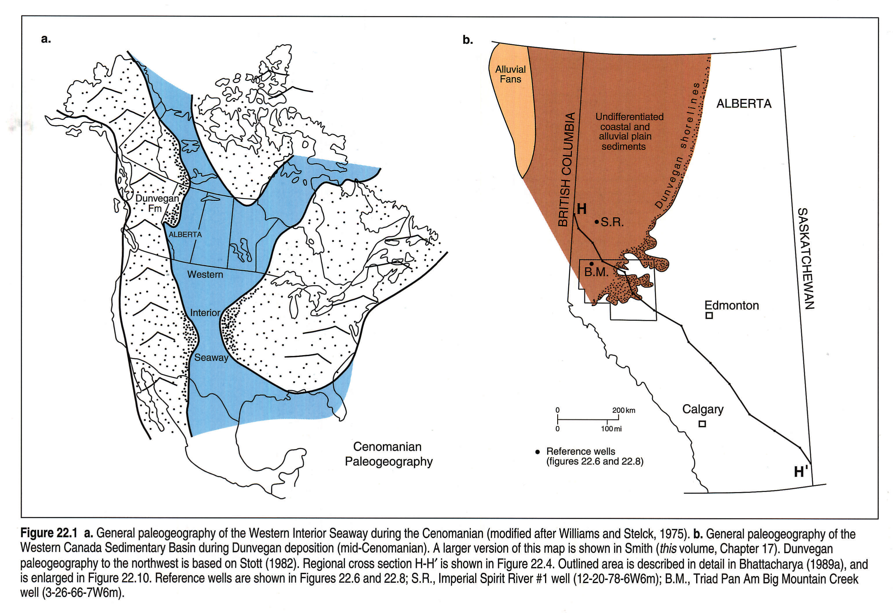
The middle Cenomanian (lowermost Upper Cretaceous) Dunvegan Formation is a lithostratigraphically defined unit that comprises an extensive, southeasterly thinning, sandy clastic wedge confined to northwestern Alberta, northeastern British Columbia, and extending as far north as the Northwest Territories (Fig. 22.1). It presently covers an area of about 300 000 km2. This includes undeformed and relatively flat-lying strata, which lie in the subsurface south of the Peace River, and which are exposed along the Peace River valley and farther north (Fig. 22.2). Where the Dunvegan is not structurally deformed, it dips gently to the southwest (Fig. 22.2). To the west, along the central and northern foothills, the Dunvegan Formation becomes incorporated into the tectonically deformed belt, where it is also exposed.
The Dunvegan Formation attains thicknesses of about 350 m, and consists of interbedded mudstone, sandstone, and conglomerate. The conglomeratic facies are confined to the outcrops in the far north (Fig. 22.1b). Thinner beds of coal and shelly limestone also are present in places. The Dunvegan cannot be mapped much farther south than the Athabasca River (Fig. 22.3), although in the subsurface, age-equivalent mudstones can be traced throughout the basin (Fig. 22.4). The Dunvegan Formation is overlain by shales of the Kaskapau Formation and underlain by shales of the Shaftesbury Formation, although the relations are better described as interfingering, since both the upper and lower boundaries are highly diachronous (Fig. 22.4).
Hydrocarbon-bearing intervals are apparently confined to the Alberta subsurface, especially in the area between Twp. 50 and Twp. 70 in ranges west of the 5th meridian (Fig. 22.2). Farther north, Doe Creek sandstones of the lower Kaskapau are also productive (Wallace-Dudley and Leckie, in press).
Tectono-Eustatic Framework
Stott (1984) interpreted the Dunvegan as having been derived from the actively rising Cordillera to the northwest during the waning phases of the Early to mid-Cretaceous Columbian Orogeny. Cant and Stockmal (1989) suggested that this may have related to accretion of the Cascadia terrane in the Western Cordillera in southern British Columbia. The wedge-shaped geometry of the Dunvegan shows that tectonic subsidence was the major control on shaping the foreland basin fill at this time. To the southwest, the Dunvegan was increasingly affected by Tertiary deformation of the Laramide Orogeny, resulting in destruction of the western edge of the Dunvegan depositional basin. The present-day southwest structural dip of the Dunvegan in subsurface (Fig. 22.2) also results from depression of the Alberta Foreland Basin as a consequence of tectonic loading.
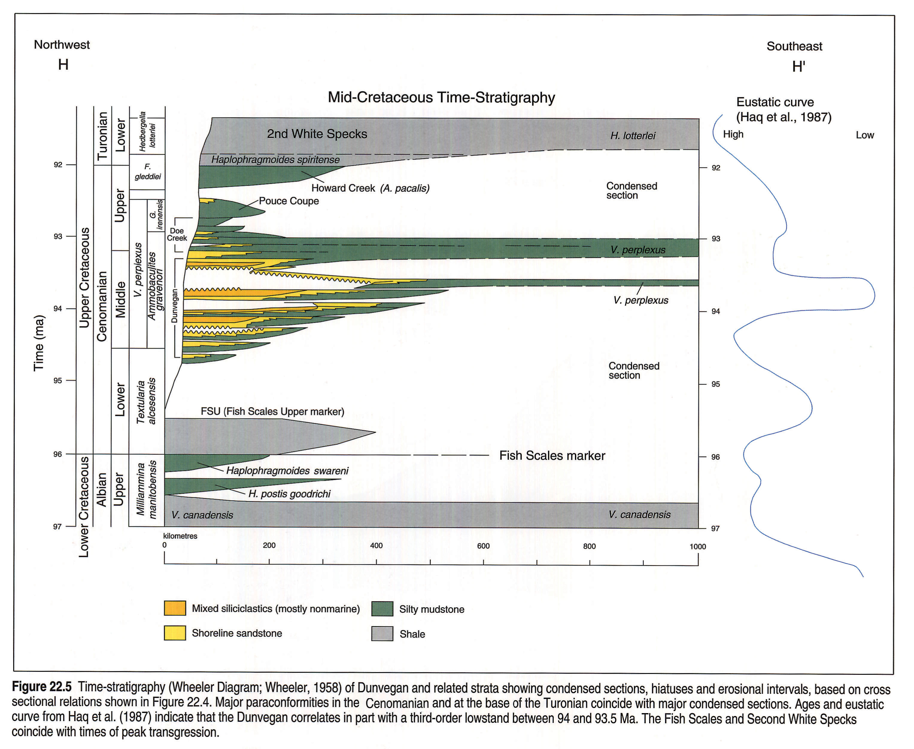
The Dunvegan wedge built into the Cretaceous Western Interior Seaway, which is interpreted to have been open all the way to the south during the mid-Cenomanian (Fig. 22.1a). Progradation was controlled, in part, by a third-order eustatic drop of sea level (Bhattacharya, 1988; Bhattacharya and Walker, 1991a), dated at 94 Ma on the global sea-level curves published by Haq et al. (1987; Fig. 22.5).
Previous Work
The name Dunvegan Group was first used by Dawson (1881) to describe his "Lower Sandstones" which cropped out along the Peace River valley. The formation was named after the Dunvegan Trading Post situated by the Peace River (Twp. 80 Rge. 3W6), although only the upper, largely nonmarine portion of the Dunvegan is exposed there. McLearn (1919) subsequently changed the Dunvegan from group to formational status. Biostratigraphically oriented work, centered on the age and correlation of the Dunvegan, Kaskapau, and Shaftesbury formations, was completed by researchers at the Alberta Research Council and the University of Alberta (Stelck and Wall, 1955; Stelck et al., 1958) and has been summarized by Caldwell et al. (1978). More recent work by Singh (1983) details the palynological aspects of the Dunvegan and their implications for Cenomanian biostratigraphy.
Stott (1982) completed a major study of the Dunvegan in outcrop and included a detailed historical summary of early work, including definition and nomenclature of the formation. In much of this previous work, the Dunvegan was interpreted as broadly deltaic, and the term "Dunvegan Delta" was applied to this rather complex sedimentary package. Stott's mapping and paleogeographic interpretations are incorporated into Figures 22.1, 22.2, and 22.3. More detailed sedimentological descriptions of selected Dunvegan outcrops, originally mapped by Stott (1982), have been published by Plint and Hart (1988). The only detailed petrological work is that published by Tater (1964), who examined sandstones in the type area at Dunvegan.
Previous subsurface work is that of Burk (1963). Burk (1963) presented a gross sandstone isolith map of the Dunvegan and established the overall southeast thinning in the subsurface, although he did not make any attempt at further stratigraphic subdivision. Bhattacharya (1988, 1989a,b and 1991) and Bhattacharya and Walker (1991a,b) completed a major study of the Dunvegan in the Alberta subsurface (Fig. 22.1b). Their work involved the application of sequence stratigraphic principles, as outlined by Van Wagoner et al. (1990). In designating the stratigraphic subdivisions they used allostratigraphy (North American Commission on Stratigraphic Nomenclature, 1983). An allostratigraphic unit is defined on the basis of its bounding discontinuities, rather than on gradational facies boundaries. Throughout this chapter, sequence stratigraphic terminology is indicated in brackets as it relates to the interpretations presented.
Maps
Structure
The southwest structural dip of the Dunvegan top (Fig. 22.2) is subparallel to the present-day structural strike in the Cordillera. This map is based on the contact between the Kaskapau and Dunvegan which, as shown in the cross section (Fig. 22.4), is diachronous and rises steadily to the northwest as the Dunvegan gets thicker. No physically continuous surface actually corresponds to this structure map, although at the scale of the entire basin, physical surfaces and time lines within the Dunvegan probably approximate the trend indicated. Along the left-hand side of the map the contours swing around counterclockwise and indicate dip to the south. This apparent dip change probably results from increased thickening of the Dunvegan rather than an actual change in the dip of surfaces within the Dunvegan.
Thickness and Lithology
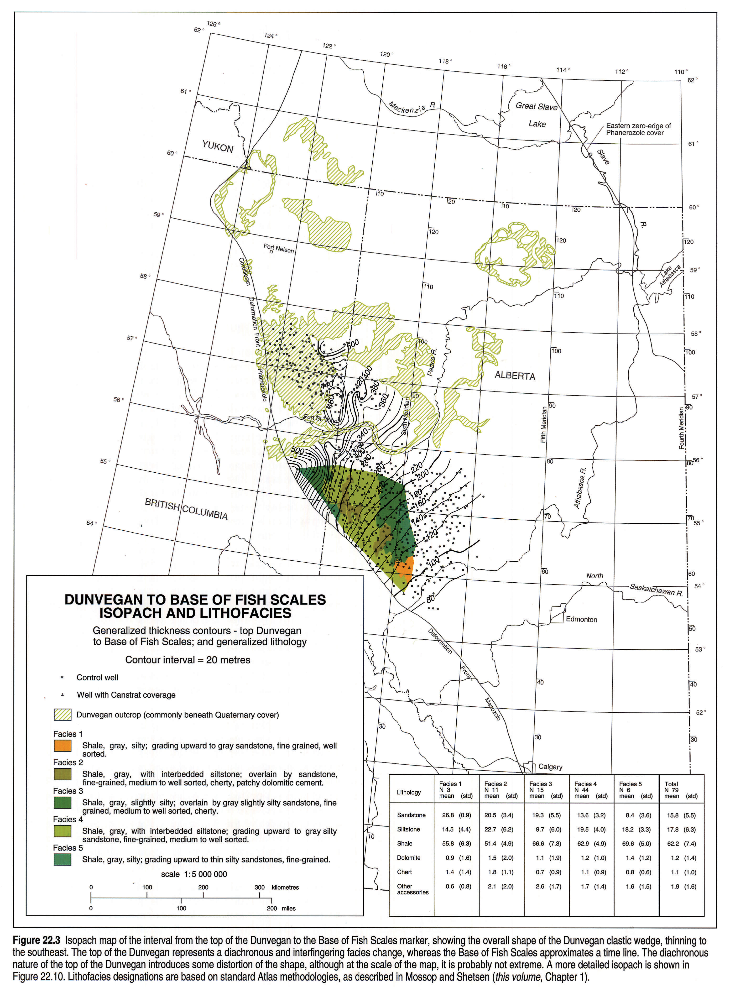
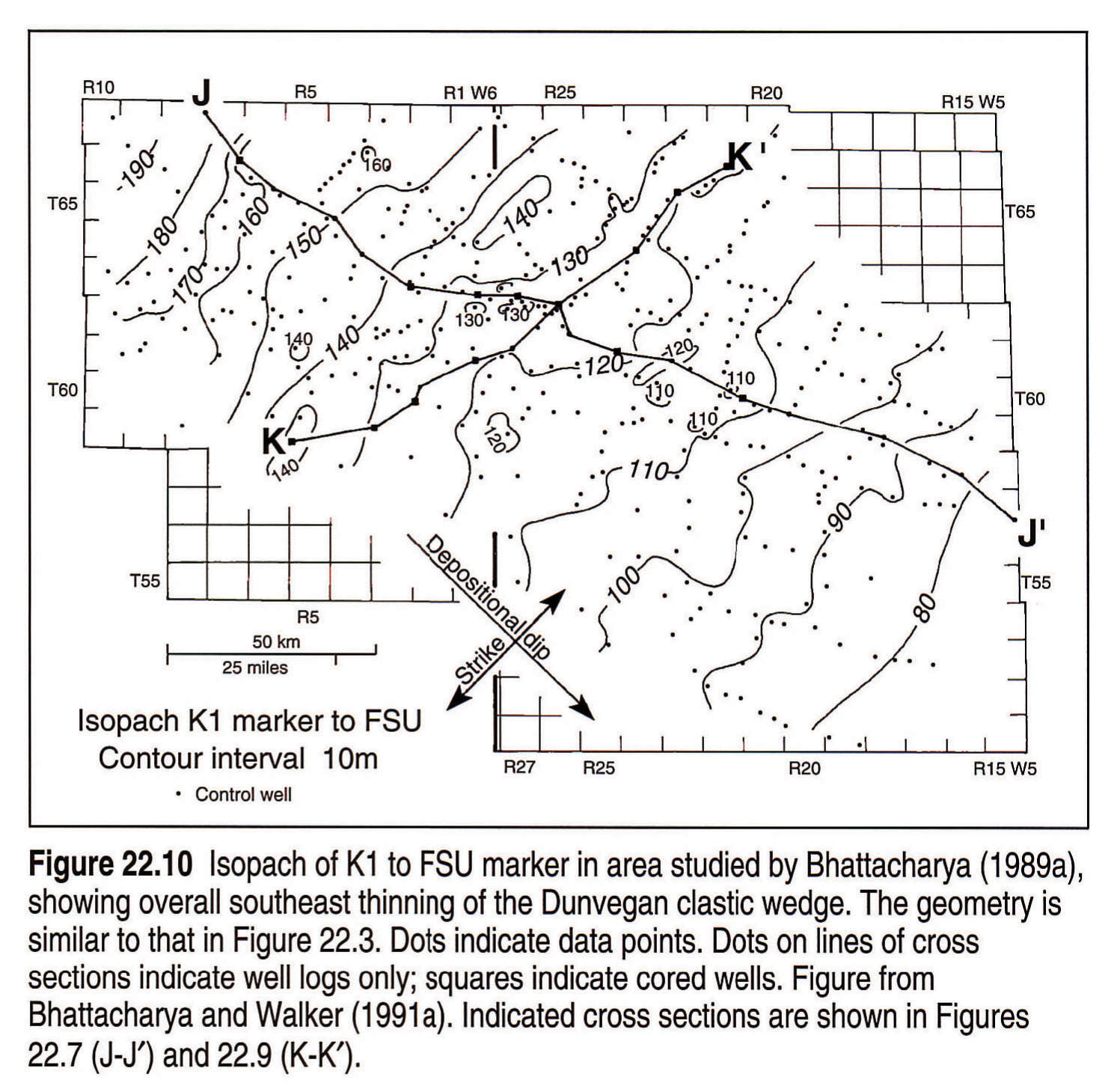
Figure 22.3 shows an isopach of the sediments between the Fish Scales marker in the Shaftesbury Formation, and the top of the Dunvegan Formation, and emphasizes the wedge-shaped geometry that thins to the southeast. The isopach values range from 480 m in the northwest to 80 m around the Athabasca River. The Fish Scales marker is interpreted as being close to a time line, although the diachronous nature of the top-Dunvegan introduces an element of distortion.
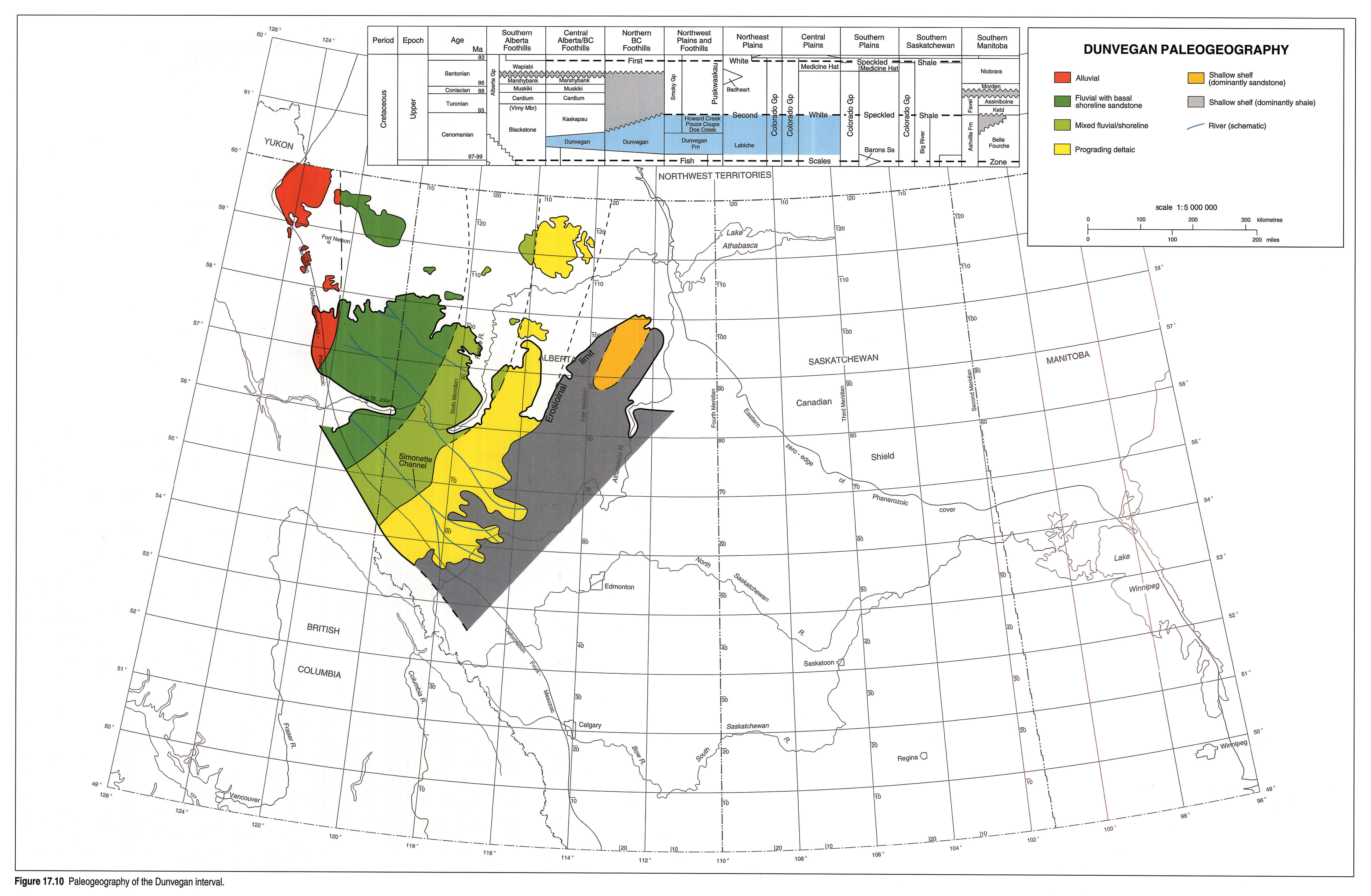
The summary paleogeography map (Fig. 22.1b) shows that conglomerates (as mapped by Stott, 1982) are predominant to the far northwest. The southeastern limit of Dunvegan shoreline sandstones (mapped by the author) is also indicated. This map is shown in greater detail in Figure 17.10 (Smith, this volume, Chapter 17).
The superimposed lithological domains (Fig. 22.3) represent a statistically derived summary of the lithologies between the top of the Dunvegan and the Base of Fish Scales. The map thus includes both Dunvegan sandstone and upper Shaftsbury shale, although data are available only over a restricted area relative to total Dunvegan distribution. The map indicates some interesting north-south trends, although an interpretation of these in terms of mapped depositional systems is not clear.
Stratigraphy
Regional Correlation
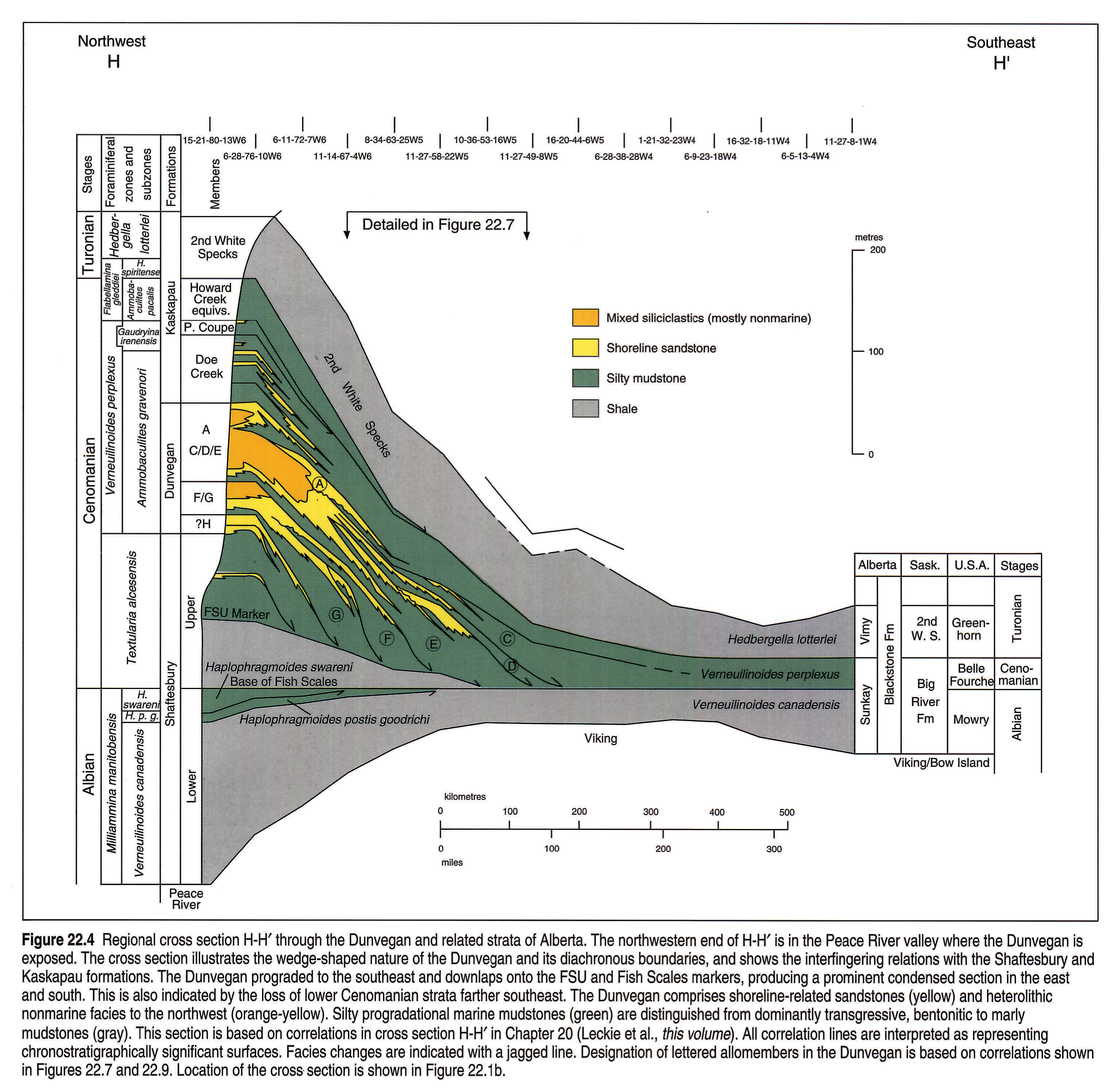
Figure 22.4 shows the regional lithostratigraphic and allostratigraphic relations of the Dunvegan Formation and related strata, with relevant biostratigraphic units also shown. The time-stratigraphic interpretation of this cross section is shown in Figure 22.5.
The Dunvegan Formation correlates eastward with shales of the La Biche Formation and to the south with shales of the Sunkay Member of the Blackstone Formation. In the Alberta and Saskatchewan subsurface, it correlates with the silty shales that lie between the Second White Specks and the Fish Scales. It broadly correlates with the upper Ashville in Manitoba and with the upper portion of the Big River Formation in Saskatchewan. In the Western Interior of the U.S.A., the Dunvegan correlates with the Belle Fourche shale (Rice, 1984), portions of the Frontier and Dakota formations, and is generally equivalent to Woodbine strata in Texas.
Shaftesbury/Dunvegan
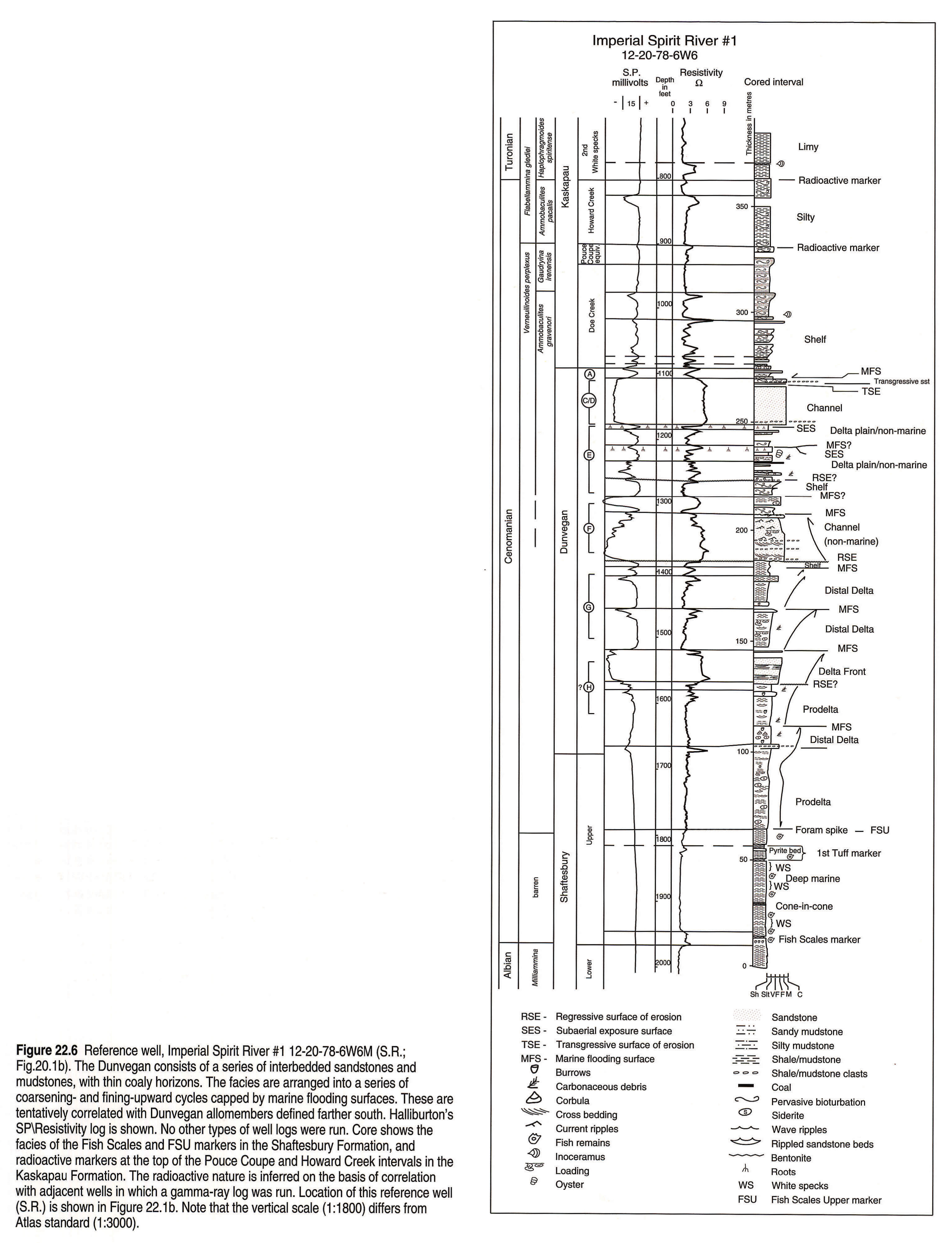
Regional cross section H-H' (Fig. 22.4) indicates that strata in the lower part of the Dunvegan downlap to the southeast. The downlap surface is represented by a prominent marker designated as the FSU (Fish Scales Upper). The FSU lies within the upper Shaftesbury, above the Fish Scales, although it merges with the Fish Scales to the southeast. Core across the FSU marker shows a dramatic lithological change (Fig. 22.6). Dark, greenish black, fish-scale-bearing bentonitic shales, lacking burrows, underlie the FSU marker and are interpreted as representing deposition in deep water, below wave base. Above, the strata consist of sideritic, rippled, silty mudstones without fish scales, and indicate deposition in shallower water, probably above storm wave-base. This abrupt transition is interpreted as marking the change from deep-water marine conditions into the shallower water brackish conditions caused by progradation of deltaic depositional systems of the Dunvegan. Thus, the strata above the FSU marker are genetically related to Dunvegan progradation, whereas the shales below are unrelated to Dunvegan progradation and represent deposition during an earlier time of peak transgression (Bhattacharya and Walker, 1991a). This interpretation is also shown in a detailed cross section highlighting the allostratigraphic relations (Fig. 22.7). It shows that allomembers in the lower portion of the Dunvegan pass seaward (southeastward) into equivalent shales of the upper Shaftesbury Formation above the FSU marker. Bentonites just below this horizon also provide important time markers for local correlation (Fig. 22.6).
The allostratigraphic relations also help to explain the loss of several biozones at the Fish Scales to the southeast (Figs. 22.4, 22.5). The Fish Scales is a major, basin-wide marker horizon that has been interpreted as representing a condensed section deposited during a long period of very slow sedimentation (Leckie et al., 1992), an interpretation supported by the downlapping nature of overlying units documented here (Figs. 22.4, 22.7). It has been used to subdivide stratigraphically the Shaftesbury Formation into upper and lower units, and also has been interpreted as marking the contact between the Upper and Lower Cretaceous (Albian/Cenomanian boundary, Caldwell et al., 1978; Singh, 1983).
A detailed foraminiferal biostratigraphy has been developed for these strata in the Peace River area to the northwest, although several of the zones are absent farther south and east (Caldwell et al., 1978). To the northwest, where the stratigraphic section is thick, the Dunvegan includes fauna of the Verneuilinoides perplexus and Textularia alcesensis zones (Figs. 22.4, 22.5). In addition, the Haplophragmoides swareni and Haplophragmoides postis goodrichi subzones of the older Milliammina manitobensis zones can be recognized in the shales immediately below the Fish Scales (Fig. 22.4). The H. swareni, H. postis goodrichi, and T. alcesensis zones and subzones have not been recognized to the southeast and have been described as missing (Caldwell et al., 1978). The regional cross section (Fig. 22.4) shows these units terminating against the Fish Scales marker as the succession thins and becomes more condensed. In the extreme southeast (Fig. 22.4) the V. perplexus Zone directly overlies the V. canadensis Subzone and defines a significant paraconformity (Caldwell et al., 1978). The estimated durations of these paraconformities (here interpreted as condensed sections) are indicated on the time-stratigraphic representation (Fig. 22.5). The absolute ages are taken from Haq et al., (1987).
Internal Dunvegan Subdivisions
Over the middle part of the basin (Fig. 22.1b), the Dunvegan was subdivided by Bhattacharya and Walker (1991a) into seven allomembers (A to G) separated from each other by laterally extensive, transgressive, marine flooding surfaces (Figs. 22.7, 22.8, 22.9). The allomembers were further subdivided into sets of offlapping, shingled units, termed shingles (Fig. 22.7), which provided the basis for detailed mapping of depositional systems discussed in a later publication (Bhattacharya and Walker, 1991b; Bhattacharya, 1991).
The allomembers broadly represent progradational cycles beginning with marine mudstones at the base and passing upward through transitional interbedded mudstones, siltstones, and sandstones into shallow marine, shoreline sandstones. These are overlain by heterolithic nonmarine facies, including coals and paleosols, which are thickest in allomembers D and E (Figs. 22.6, 22.8). The non-marine facies increase in thickness and proportion to the northwest (Fig. 22.7).
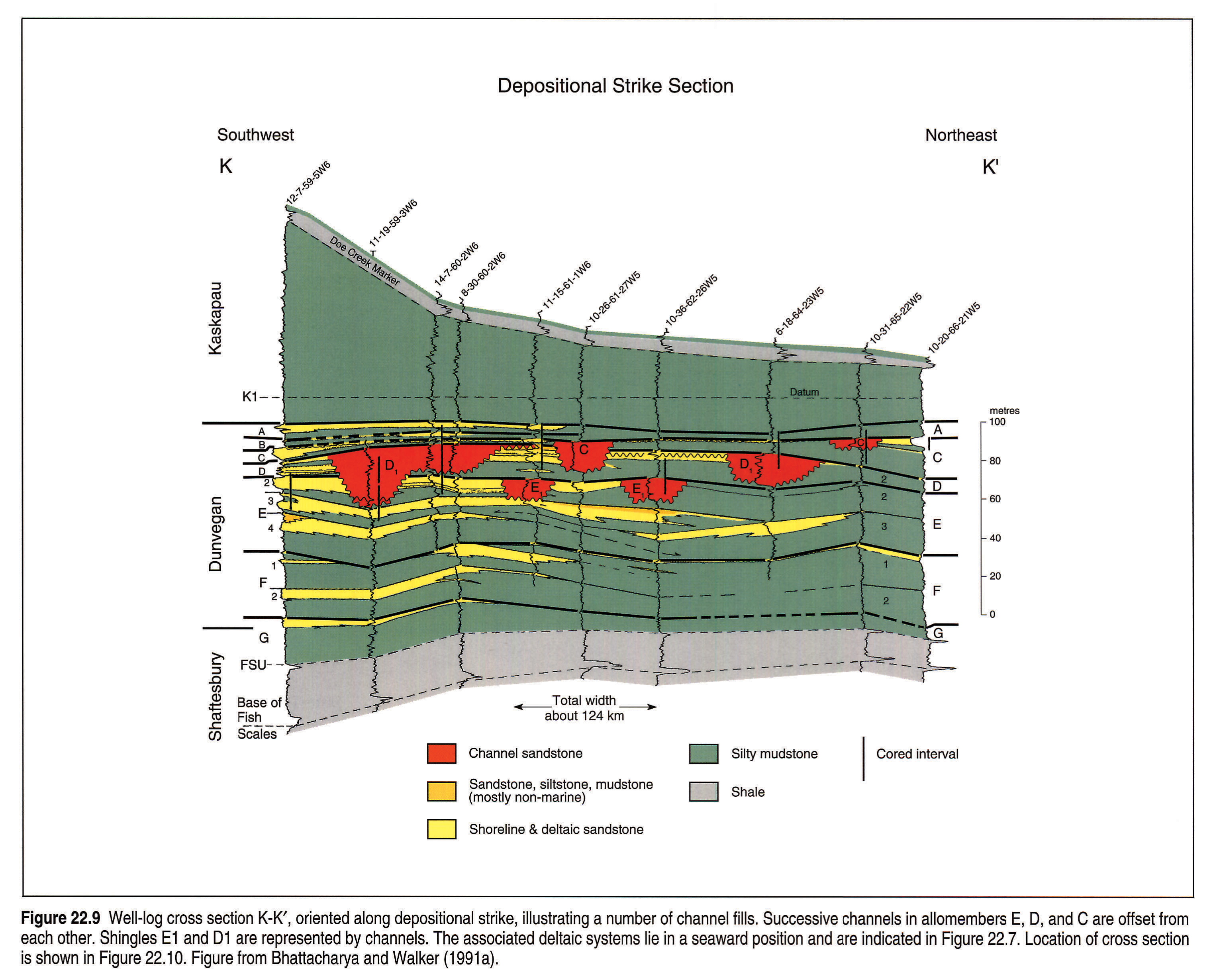
Erosional surfaces in the middle portion of the Dunvegan are indicated by channelized units in allomembers E, D, and C, and correlate with nonmarine intervals in interfluve areas (Figs. 22.7, 22.9). These channels have also been recognized in outcrop (Plint and Bhattacharya, 1991) and show paleocurrent flows dominantly to the southeast (Plint and Hart, 1988). The channels tend to be filled with sandstone that has been referred to as "the arkosic member" in outcrops described by previous workers (Stelck et al., 1958). The channel fills in Figure 22.9 are dominated by fine-to medium-grained sandstone. Previous workers have also speculated that the Dunvegan contains a significant unconformity, indicated by the deeply incised nature of the "arkosic member" in outcrop (Stelck et al., 1958). The cross sectional relations documented in Figure 22.9 show that there were several phases of channeling causing erosional surfaces at several different levels. In any given outcrop section or well, however, usually only one channel is observed (Fig. 22.9). The portion of the Dunvegan containing channels is interpreted as being broadly correlative with the time of maximum progradation of the Dunvegan (corresponding to allomembers C, D, and E), and may correlate with the conglomerate facies mapped by Stott (1982) in northern British Columbia (Fig. 22.1b). Channels are found in the older allomembers in the northwest portion of the map area and in places lie directly on upper Shaftesbury shales. Sediments of allomember C extend farther into the basin (i.e., southeast) than any other formally defined allomembers (Fig. 22.4).
Several of the marine flooding surfaces defined by Bhattacharya (1988) have been traced to the northwest (Plint, pers. comm.), including those capping allomembers E, F, and G. The correlations to the north (Fig. 22.4) also indicate the additional presence of several older progradational units that probably represent older allomembers.
Dunvegan/Kaskapau
The upper allomembers in the Dunvegan (allomembers A, B) lie progressively farther to the northwest, indicating a retrogradational or backstepping pattern (Figs. 22.4, 22.7). To the southeast, these units interfinger with shale of the Kaskapau Formation. Like the Shaftesbury/Dunvegan contact, the Dunvegan/Kaskapau contact is diachronous, and becomes progressively younger in a landward position (i.e., to the northwest). In the Foothills outcrop along the Pine River (in B.C.), Spieker (1922) designated the upper part of the Dunvegan Formation as the Sukunka Member. Stelck and Wall (1955) indicated that the Sukunka Member correlates with the basal Kaskapau farther to the east, although Stott (1982) suggested that this was not so, and that beds of the Sukunka dipped below the Kaskapau farther eastward. Direct correlations of the Sukunka Member in the Pine River section to the subsurface have not yet been attempted.
Doe Creek/Pouce Coupe
Among the sandy units in the lower part of the Kaskapau Formation are the Doe Creek, Pouce Coupe, and Howard Creek sandstones (Figs. 22.4, 22.6). Wallace-Dudley and Leckie (in press) have shown that the Doe Creek/Pouce Coupe sandstones comprise a series of backstepping sandy units (i.e., parasequences) culminating in highly radioactive shales of the Second White Specks, which probably represent another condensed section, similar to others documented in the Cretaceous of Western Canada (Leckie et al., 1990). The Pouce Coupe represents the most landward sandy tongue recognized (Wallace-Dudley and Leckie, in press). It thins to the southeast and ultimately disappears completely, although it is not clear whether the Pouce Coupe interval has been eroded or was never deposited farther east and south. The younger Howard Creek is a thin, sandy unit that lies a little farther east into the basin than the Pouce Coupe.
Two radioactive markers correlate with the top of the Howard Creek and the top of the Pouce Coupe intervals, respectively (Fig. 22.6). The lower marker coincides with the top of the Doe Creek farther south and east, where the Pouce Coupe is missing (Fig. 22.8). These markers intersect the Imperial Spirit River well (Fig. 22.6) and allow correlation with the detailed foraminiferal biostratigraphy developed for that area (Stelck and Wall, 1955). The upper marker coincides with the Cenomanian/Turonian boundary and marks the base of the Second White Specks shale (contact between the Haplophragmoides spiritense and Ammobaculites pacalis subzones of the Flabellammina gleddiei zone). The lower marker coincides with the contact between the Verneuilinoides perplexus and Flabellammina gleddiei foraminiferal zones.
The section between the top of the Dunvegan and the base of the Second White Specks thins dramatically eastward as a result of the loss of the Pouce Coupe and Howard Creek intervals. The foraminiferal biozones associated with these strata (Flabellammina gleddei Zone) are also missing farther to the southeast (Fig. 22.5) resulting in another biostratigraphically defined paraconformity (Caldwell et al., 1978). At Watino (Twp.77 Rge.23W5) the Second White Specks has been described as directly and unconformably overlying sands of the Dunvegan Formation (Stelck et al., 1958). However, in the subsurface of this area, thick sandstones of the Doe Creek are difficult to distinguish from the Dunvegan. Given that the Doe Creek and Dunvegan are contained within the same biozone (V. perplexus) it is possible that the unconformity is not as profound as previously suggested. In places in the extreme southeast, Dunvegan-equivalent strata are missing completely and the H. lotterlei Zone overlies the older M. manitobensis Zone. This may simply be a function of the extreme condensation of the entire stratigraphic section to the southeast. In addition, the deeper water nature of the basin farther south may have precluded the existence of benthic arenaceous foraminifera. A similar explanation may account for the paraconformity developed lower in the section at the Fish Scales horizon.
Reference Wells
Two reference wells highlight the depositional facies, degree of cyclicity, and the major well-log markers.
Imperial Spirit River #1, 12-20-78-6W6, (Fig. 22.6) includes core from the Fish Scales through the Second White Specks and is the only well known to have cored through the FSU marker. The Dunvegan is here about 170 m thick and contains several coarsening- and fining-upward facies successions capped by marine flooding surfaces. This well is north of the area used by Bhattacharya and Walker (1991a) to define their seven allomembers, and the exact correlation of their stratigraphy into this well is uncertain. The positions of the allomembers are tentatively indicated.
Two 20 m thick interpreted channelized sands are present at 1150 and 1350 ft. Two non-marine, rooted horizons are also present in the upper half of the Dunvegan at 1180 and 1220 ft. The detailed biostratigraphy of Stelck and Wall (1955), discussed above, is also shown. Foraminiferal recovery from the upper Shaftesbury in the lower part of the well was sparse, although Milliammina was found below the Fish Scales (Wall, pers. comm.).
The upper part of the Spirit River well was originally logged by Halliburton, with the final re-logging of the entire well completed by Schlumberger. The Halliburton log is shown here, although the stratigraphic picks are about 10 ft. higher than in the Schlumberger log.
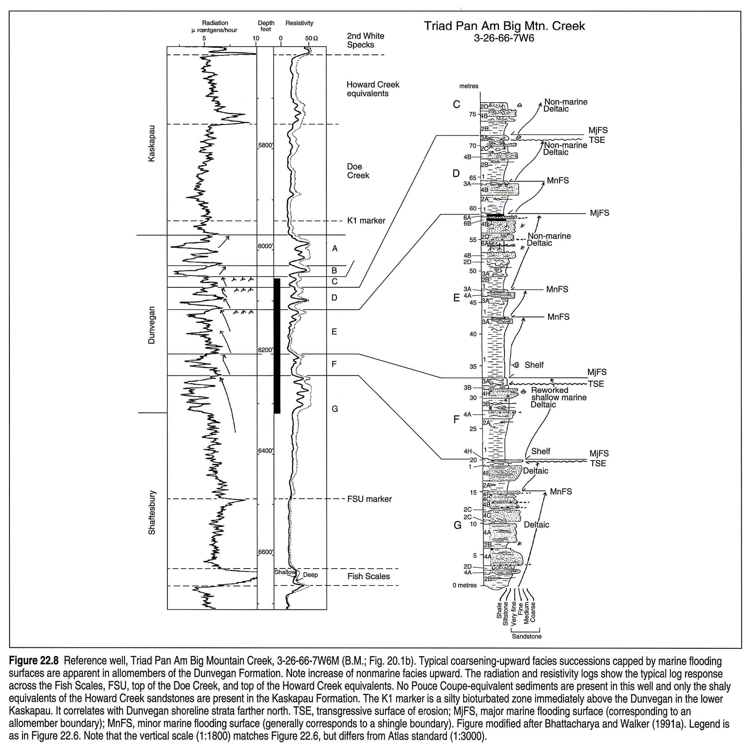
The Triad Pan Am Big Mountain Creek well, 3-26-66-7W6 (Fig. 22.8), is in the northwestern part of the area studied in detail by Bhattacharya and Walker (1991a,b; Fig. 22.1b). It contains a fairly complete core through the lower and middle part of the Dunvegan, from allomembers G, F, E, D, and C. Here the Dunvegan is about 100 m thick and also consists of a series of coarsening-upward successions capped by marine flooding surfaces. The facies in allomembers E, D, and C include nonmarine strata, and are broadly interpreted as representing progradational deltaic shoreline sediments. The well also shows the characteristic gamma and resistivity log response through the Dunvegan, Shaftesbury and Kaskapau. This includes the radioactive marker horizons associated with the Fish Scales, FSU, Doe Creek and Howard Creek. A silty, bioturbated horizon in the lower Kaskapau (designated as the K1 marker) was used as a datum for mapping and correlation. No Pouce Coupe-equivalent strata are interpreted as existing in this well.
Paleogeography and Depositional History
Bhattacharya (1989a) completed a detailed study of the allostratigraphy, facies, and depositional systems of the Dunvegan Formation in the Alberta subsurface. His study area ranged from Twp. 50 to Twp. 67 and from Rge. 15W5 to the deformed belt in the west (Figs. 22.1b, 22.10). The study incorporated data from about 500 well logs and 130 cores. Individual isopach and sand isolith maps and detailed facies interpretations of the Dunvegan allomembers and shingles are presented in Bhattacharya (1989a, 1991), and Bhattacharya and Walker (1991 a,b).
As a result of this work, a range of distinct depositional systems was interpreted in the Dunvegan Formation, from highly river-dominated deltas in allomember E, to transgressive sheet sands in allomember C (Bhattacharya and Walker, 1991b). The paleogeographic reconstructions presented here are based on sand body geometries and facies relations documented in Bhattacharya (1989a). The most generalized paleogeography for the Dunvegan indicates shorelines trending northeast-southwest fed by southeast-flowing rivers (Fig. 22.1b).
Sandstones in the five shingles of allomember G (Fig. 22.7) were collectively mapped and indicate a series of overlapping lobate sand bodies interpreted as representing deltas (Fig. 22.11a). The presence of wave ripples and hummocky cross-stratification in cored delta front sandstones indicates a wave-influenced depositional setting. Isopach values of allomember G reach up to 80 m in the west where the deltas are confined. Deposition of allomember G was terminated by a widespread transgression with succeeding marine shales blanketing the area (Fig. 22.11b), although these are not very thick.
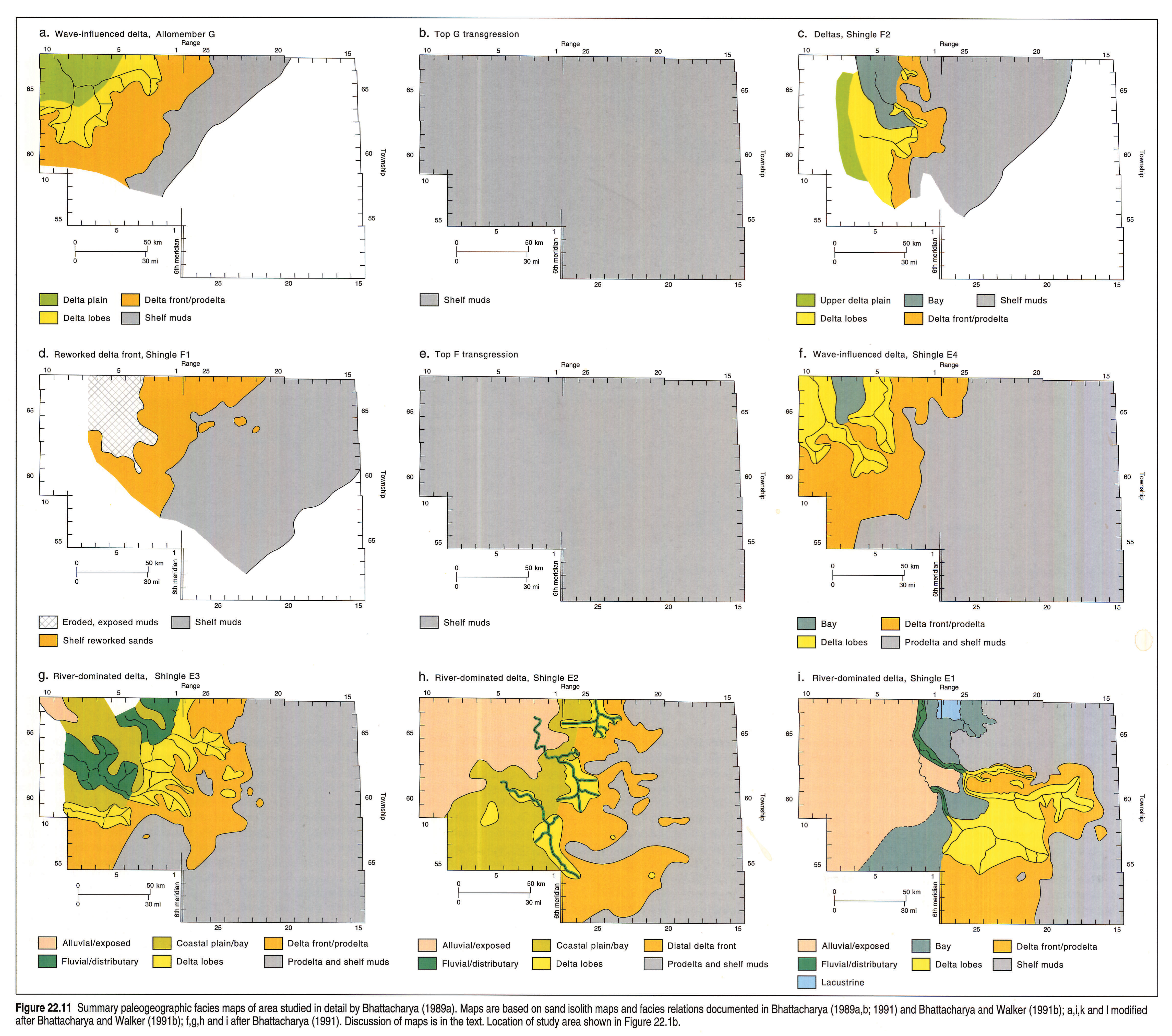
Allomember F contains two offlapping shingles (Fig. 22.7). Mapping of shingle F2 indicates a prograding delta consisting of three sub-lobes (Fig. 22.11c). The sand body geometries and cored facies indicate fluvially dominated deltas. Associated feeder channels are seen in well-log cross sections farther northwest. Shingle F1 is only partly preserved and is interpreted as having been largely reworked into linear shelf sands. It is truncated to the northwest by the transgression that terminates allomember F (Fig. 22.11d) and is blanketed by thin transgressive mudstones (Fig. 22.11e) that have been traced farther north (Plint, pers. comm.).
Allomember E has been subdivided into four prograding shingles that extend successively farther seaward (Fig. 22.7). These are shown in Figure 22.11f to 22.11i, and are interpreted as deltaic. Shingle E4 is intrepreted as an elongate, river-dominated delta with two main lobes (Fig. 22.11f). The presence of wave ripples and hummocky cross-stratification in cored delta front sandstones indicates some wave influence. Shingles E3, E2, and E1 (Figs. 22.11g, h, i) also consist of rather elongate sand bodies, but the general shape and lack of wave-produced sedimentary structures in core indicates that they are highly river dominated (Bhattacharya, 1991). Shingle E3 (Fig. 22.11g) comprises three main feeder channels with associated lobes that also have an elongate geometry. Shingle E2 (Fig. 22.11h) has three main lobes that have an elongate to birdsfoot shape. The northwest part of the map is a zone of nondeposition and sedimentary bypass.
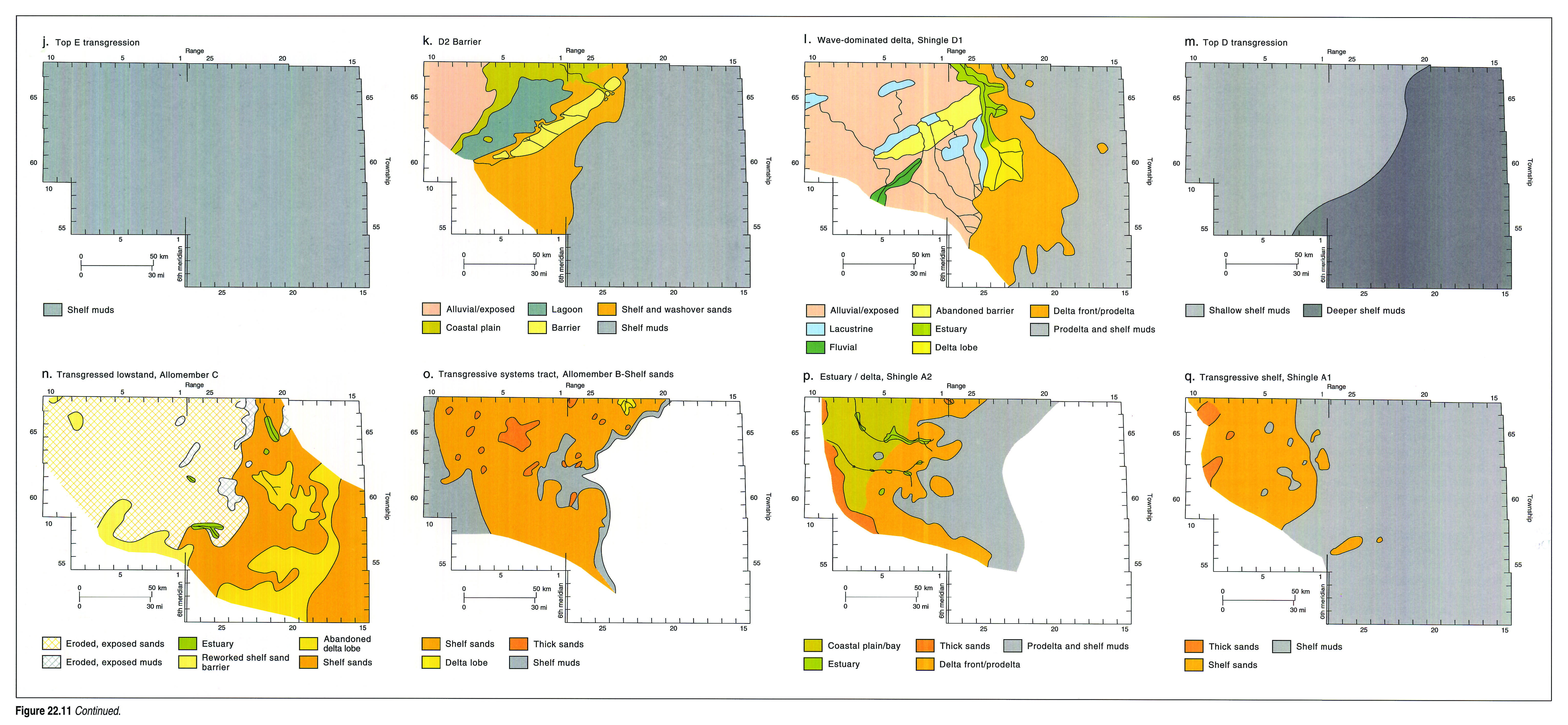
Each of shingles E4, E3, and E2 contain several channels and associated lobes (Fig. 22.11f, g, h). Shingle E1, in contrast, seems to have been associated with a single major river that fed a larger and less spread out delta complex (Fig. 22.11i). There also is a marked basinward shift in the general shoreline position. The entrenchment of the fluvial systems and abrupt seaward shift in facies has been interpreted as possibly representing an erosional unconformity (i.e., type 1 sequence boundary) resulting from a eustatic drop of sea level at 94 Ma (Bhattacharya and Walker, 1991a). E1 progrades farther seaward than any other shingle in allomember E and may represent a lowstand delta. It is abruptly overlain by blanketing marine mudstones representing another major transgression (Fig. 22.11j). This is followed by progradation of allomember D.
Allomember D contains three offlapping shingles (Fig. 22.7), although the lowest shingle (D3) is rather poorly expressed. The sand isolith maps and facies successions in shingle D2 show a linear, shore-parallel sand body interpreted as a wave-dominated prograding barrier/lagoon system (Fig. 22.11k), quite different from the more river-dominated systems in allomember E. Although they were not originally mapped separately (Bhattacharya, 1989b), cross sectional relations indicate that shingle D1 incises into the older D2 barrier (Fig. 22.9). The depth of erosion shown in Figure 22.9 indicates a major valley system with a possible associated lowstand delta developed (shown on Fig. 22.11l). The sand isolith maps and facies successions in the lowstand delta indicate that it was wave dominated. During the initial phases of transgression, following the deposition of the D1 delta, the associated feeder channels and incised valleys were filled with marine sediments and transformed into estuaries (Bhattacharya, 1989b). These are distinctly different from the predominantly fluvial-dominated channel fills associated with allomember E, as documented by Bhattacharya and Walker (1991b). Allomember D is blanketed by transgressive marine shales (Fig. 22.11m).
Allomember C progrades farther seaward than any other allomember and contains at least two shingles (Fig. 22.7), although it is not very sandy in the study area. Allomember C is transgressed by a relatively thin sheet sandstone that is replete with Ophiomorpha burrows. Transgressive erosion occurred at the base of the sheet-sandstone, and much of allomember C is interpreted to have been eroded or transgressively reworked. The erosion is more pronounced to the northwest of the line shown on the map (Fig. 22.11n) which possibly marks the position of some kind of former break in slope. Remnants of channels that probably fed silty lobes to the southeast are preserved in places (Fig. 22.11n), although core indicates that the channel fills are predominantly estuarine in nature, similar to those in allomember D (Bhattacharya, 1989a). Farther northeast, outside of the detailed study area, preliminary correlations indicate sandy, deltaic lobes (Fig. 22.1b).
After the transgression at the top of allomember C, subsequent allomembers and shingles of the Dunvegan never prograded as far basinward as older allomembers. This resulted in the backstepping pattern shown in Figures 22.4 and 22.7. Allomember B is relatively limited in extent and associated sandy facies are extensively reworked and burrowed, indicating a transgressive depositional environment (Fig. 22.11o).
A phase of channel incision is indicated in shingle A2 of allomember A (Fig. 22.11p). The channels were filled estuaries, and sandy deltaic deposits are not observed seaward of the channel mouths. The upper portions of allomember A (shingle A1, Fig. 22.11q) are extensively reworked, also indicating transgressive modification, similar to that in allomember B. This style of sedimentation appears to be continued in the overlying Doe Creek sandstones (Wallace-Dudley and Leckie, in press).
Additional sedimentological details of the units discussed in this section are presented in Bhattacharya (1989a,b, 1991) and Bhattacharya and Walker (1991b).
General Geological History and Discussion
The geological history of the Dunvegan Formation can be viewed overall as a regressive-transgressive cycle. The initial regression began in the middle Cenomanian, as shallow-marine deltaic facies of the lower Dunvegan (allomembers F, G, and older) were deposited over the deeper marine transgressive shales of the upper Shaftesbury (i.e., the shales below the FSU marker). This regression resulted in downlapping over the surface represented by the FSU marker and shows that shales of the upper Shaftesbury above the FSU marker are genetically related to Dunvegan progradation.
Peak regression occurred during deposition of allomembers E, D, and C, as indicated by a pronounced seaward shift in the position of fluvial, channelized facies and their associated deltas. This seaward shift may have been driven by a third-order eustatic drop of sea level at 94 Ma (Fig. 22.5; Bhattacharya, 1988; Bhattacharya and Walker, 1991a). Indication of subsequent Kaskapau transgression is first indicated by a transgressive surface of erosion at the top of allomember C, which may correlate with a rapid global rise of sea level at 93.5 Ma (Fig. 22.5). Dunvegan deltaic deposition never recovered from this transgression, and the facies show evidence of progressive deepening, culminating in the deep-water, calcareous shales of the Second White Specks (Vimy Member of the Blackstone) deposited in the early Turonian. These calcareous shales correlate with the transgressive Greenhorn Limestones farther south in the Western Interior of the United States (Rice, 1984) and coincide with a time of globally high sea level (Haq et al., 1987). Dunvegan deposition is interpreted as being broadly correlative with a third-order eustatic cycle of sea level.
Dunvegan progradation was interrupted by several transgressive events that resulted in at least seven marine tongues within the Dunvegan. These are interpreted as resulting from tectonically induced subsidence during periods of renewed thrusting in the Cordillera (Bhattacharya, 1988 1989a; Bhattacharya and Walker, 1991a), although no attempt has yet been made to correlate the flooding events with specific tectonic episodes. These seven events are beyond the limits of stratigraphic resolution in terms of absolute time and are inferred to have been relatively rapid (a hundred thousand years or so). In general, the overall wedge shape of the Dunvegan and related strata indicates a tectonically formed basin. The nature of the basin fill, however, is interpreted as recording a combination of tectonic and eustatic effects. Autocyclic processes were probably responsible for producing some of the deltaic cycles seen in the various Dunvegan shingles within the allomembers.
Acknowledgements
This paper represents the culmination of work begun as a Ph.D. under the supervision of R.G. Walker at McMaster University and continued as a post-doctoral fellow at the Alberta Geological Survey (AGS), supervised by G.D. Mossop. Funding for much of the work was provided by the Natural Sciences and Engineering Research Council (NSERC) in the form of strategic and operating grants to R.G.W. and scholarships and fellowships to J.B. The AGS and the Geological Survey of Canada provided additional financial support.
Special thanks go to Sheila Stewart who helped compile the outcrop geology. David Safton helped in constructing initial cross sections to the north.
J.H. Wall, C.R. Stelck, and C. Singh are thanked for providing their expertise on the Dunvegan and related strata. A.G. Plint is acknowledged for contributing some of his ideas based on a re-evaluation, currently in progress, of the Dunvegan in outcrop. Finally, I thank reviewers Ross Mclean and Brad Hayes, whose insightful comments resulted in significant improvements to the manuscript.
References
- Bhattacharya, J. 1988. Autocyclic and allocyclic sequences in river- and wave-dominated deltaic sediments of the Upper Cretaceous Dunvegan Formation, Alberta: core examples. In: Sequences, Stratigraphy, Sedimentology; Surface and Subsurface. D.P. James and D.A. Leckie (eds.). Calgary, Canadian Society of Petroleum Geologists, Memoir 15, p. 25-32.
- Bhattacharya, J. 1989a. Allostratigraphy and river- and wave-dominated depositional systems of the Upper Cretaceous (Cenomanian) Dunvegan Formation, Alberta. Unpublished Ph.D. thesis, McMaster University, Hamilton, Ontario, 588 p.
- Bhattacharya, J. 1989b. Estuarine channel fills in the Upper Cretaceous Dunvegan Formation: core examples. In: Modern and Ancient Examples of Clastic Tidal Deposits - A Core and Peel Workshop. G.E. Reinson (ed.). Canadian Society of Petroleum Geologists, Calgary, Alberta, p. 37-49.
- Bhattacharya, J. 1991. Regional to sub-regional facies architecture of river-dominated deltas, Upper Cretaceous Dunvegan Formation, Alberta sub-surface. In: The Three-dimensional Facies Architecture of Terrigenous Clastic Sediments and its Implications for Hydrocarbon Discovery and Recovery. A.D. Miall and N. Tyler (eds.). SEPM (Society for Sedimentary Geology), "Concepts and Models in Sedimentology and Paleontology", v. 3, p. 189-206.
- Bhattacharya, J. and Walker, R.G. 1991a. Allostratigraphic subdivision of the Upper Cretaceous Dunvegan, Shaftesbury, and Kaskapau formations in the northwestern Alberta subsurface. Bulletin of Canadian Petroleum Geology, v. 39, p. 145-164.
- Bhattacharya, J. and Walker, R.G. 1991b. River- and wave-dominated depositional systems of the Upper Cretaceous Dunvegan Formation, northwestern Alberta. Bulletin of Canadian Petroleum Geology, v. 39, p. 165-191.
- Burk, C.F., Jr. 1963. Structure, isopach and facies maps of Upper Cretaceous marine successions, west-central Alberta and adjacent British Columbia. Geological Survey of Canada, Paper 62-31, 10 p.
- Caldwell, W.G.E., North, B.R., Stelck, C.R. and Wall, J.H. 1978. A foraminiferal zonal scheme for the Cretaceous System in the interior plains of Canada. In: Canadian Biostratigraphy. C.R. Stelck and B.D.E. Chatterton (eds.). Geological Association of Canada, Special Paper 18, p. 495-575.
- Cant, D.J. and Stockmal, G.S. 1989. The Alberta foreland basin: relationship between stratigraphy and Cordilleran terrane-accretion events. Canadian Journal of Earth Sciences. v. 26, p. 1964-1975.
- Dawson, G.M. 1881. On the geology of the region between the 54th and 56th parallels, from the Pacific Coast to Edmonton. Geological and Natural History Survey of Canada, Report of Progress for 1879-1880, p. 99b-142b.
- Green, R. 1972. Geological map of Alberta. Alberta Geological Survey, Natural Resources Division, Alberta Research Council, Edmonton, Alberta.
- Haq, B.U., Hardenbol, J. and Vail, P.R. 1987. Chronology of fluctuating sea levels since the Triassic. Science, v. 235, p. 1156-1166.
- Leckie, D.A., Bhattacharya, J., Bloch, J., Gilboy, C.F., and Norris, B. (this volume). Cretaceous Colorado/Alberta Group of the Western Canada Sedimentary Basin. In: Geological Atlas of the Western Canada Sedimentary Basin. G.D. Mossop and I. Shetsen (comps.). Calgary, Canadian Society of Petroleum Geologists and Alberta Research Council, chpt. 20.
- Leckie, D.A., Singh, C., Bloch, J., Wilson, M. and Wall, J.H. (1992). An anoxic event at the Albian-Cenomanian boundary: the Fish Scale Marker bed, northern Alberta, Canada. Paleogeography, Paleoclimatology and Paleoecology, v. 92, p. 139-166.
- Leckie, D.A., Singh, C., Goodarzi, F., and Wall, J.H. 1990. Organic-rich, radioactive marine shale: a case study of a shallow-water condensed section, Cretaceous Shaftesbury Formation, Alberta, Canada. Journal of Sedimentary Petrology, v. 60, p. 101-117.
- McLearn, F.H. 1919. Cretaceous, Lower Smoky River, Alberta. Geological Survey of Canada, Summary Report, 1918, Part C, p. 1-7.
- North American Commission on Stratigraphic Nomenclature. 1983. North American stratigraphic code. American Association of Petroleum Geologists, Bulletin, v. 67, p. 841-875.
- Plint, A.G. and Bhattacharya, J.P. 1991. Allostratigraphy in outcrop, initial results of subsurface to outcrop correlations in the Upper Cretaceous Dunvegan Formation, Alberta and British Columbia (abstract). Bulletin of Canadian Petroleum Geology, v. 39, p. 221.
- Plint, A.G. and Hart, B.S. 1988. Field guide to the Upper Cretaceous Dunvegan (Cenomanian) and Cardium (Turonian) formations in the Dawson Creek-Fort St.John area, British Columbia. Canadian Society of Petroleum Geologists field guide. Sequences, Stratigraphy, Sedimentology: Surface and Subsurface, Technical Meeting, September 14-16th, 1988, Calgary, Alberta, 51 p.
- Rice, D.D. 1984. Widespread shallow marine, storm-generated sandstone units in the Upper Cretaceous Mosby sandstone, Central Montana. In: Siliclastic Shelf Sediments. R.W. Tillman and C.T. Siemers (eds.). Society of Economic Paleontologists and Mineralogists, Special Publication 34, p. 143-161.
- Singh, C. 1983. Cenomanian microfloras of the Peace River area, northwestern Alberta. Alberta Research Council, Bulletin 44, Edmonton, Alberta, 322 p.
- Smith, D. (this volume). Paleogeographic evolution of the Western Canada foreland basin. In: Geological Atlas of the Western Canada Sedimentary Basin. G.D. Mossop and I. Shetsen (comps.). Calgary, Canadian Society of Petroleum Geologists and Alberta Research Council, chpt. 17.
- Spieker, E.M. 1922. The petroleum geology of a part of the Western Peace River District, British Columbia. American Association of Petroleum Geologists, Bulletin, v. 6, p. 112-126.
- Stelck, C.R., Wall, J.H., and Wetter, R.E. 1958. Lower Cenomanian Foraminifera from Peace River area, Western Canada. Alberta Research Council, Geological Division, Bulletin 2, Part 1, 35 p.
- Stelck, C.R. and Wall, J.H. 1955. Foraminifera of the Cenomanian Dunveganoceras Zone from the Peace River area of Western Canada. Research Council of Alberta, Report No. 70, 81 p.
- Stott, D.F. 1982. Lower Cretaceous Fort St. John Group and Upper Cretaceous Dunvegan Formation of the foothills and plains of Alberta, British Columbia, District of Mackenzie and Yukon Territory. Geological Survey of Canada, Bulletin 328, 124 p.
- Stott, D.F. 1984. Cretaceous sequences of the foothills of the Canadian Rocky Mountains. In: The Mesozoic of middle North America. D.F. Stott and D.J. Glass (eds.). Calgary, Canadian Society of Petroleum Geologists, Memoir 9, p. 85-107.
- Tater, J. 1964. The Dunvegan sandstones of the type area. Unpublished M.Sc. Thesis, University of Alberta, Edmonton, Alberta, 58 p.
- Van Wagoner, J.C., Mitchum, R.M., Campion, K.M., and Rahmanian, V.D. 1990. Siliciclastic sequence stratigraphy in well logs, cores, and outcrops: concepts for high-resolution correlation of time and facies. American Association of Petroleum Geologists Methods in Exploration Series, No. 7, Tulsa, Oklahoma, 55 p.
- Wheeler, H.E. 1958. Time stratigraphy. American Association of Petroleum Geologists, Bulletin, v. 42, p. 1047-1063.
- Wallace-Dudley, K. and Leckie, D.A. (in press). The Lower Kaskapau Formation (Cenomanian): a retrogradational shelf system, Alberta, Canada. American Association of Petroleum Geologists, Bulletin.
- Williams, G.D. and Stelck, C.R. 1975. Speculations on the Cretaceous palaeogeography of North America. In: The Cretaceous System of the Western Interior of North America. W.G.E. Caldwell (ed.). Geological Association of Canada, Special Publication No. 13, p. 1-20.