Publication Type
Map
Authored on
Topic
Oil and Gas
Publication ID
MAP 622
Publication ID Extended
Map 622
Publication
Publication Other
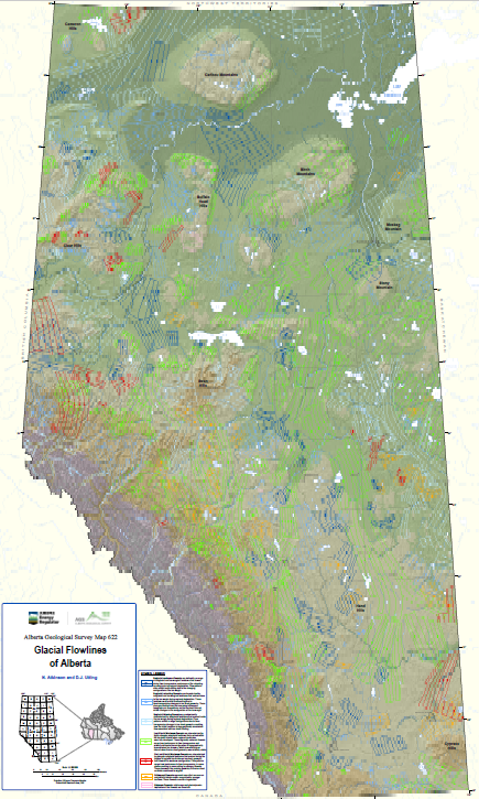
Abstract
This map depicts a generalized reconstruction of the direction and relative age of major ice flow trajectories within the Laurentide and Cordilleran ice sheets based on the morphometry, proximity, and parallel concordance of previously mapped glacial landforms. These enable a comprehensive large-scale reconstruction of evolving configuration and flow geometry of these ice sheets as they advanced and retreated across Alberta during, and potentially prior to the last glaciation.
Citation
Atkinson, N. and Utting, D.J. (2021): Glacial flowlines of Alberta; Alberta Energy Regulator / Alberta Geological Survey, AER/AGS Map 622, scale 1:1 000 000.
Preview
Place Keywords
alberta, canada
Place Keywords NTS
72e, 72l, 72m, 73d, 73e, 73l, 73m, 74d, 74e, 74l, 74m, 82g, 82h, 82i, 82j, 82n, 82o, 82p, 83a, 83b, 83c, 83d, 83e, 83f, 83g, 83h, 83i, 83j, 83k, 83l, 83m, 83n, 83o, 83p, 84a, 84b, 84c, 84d, 84e, 84f, 84g, 84h, 84i, 84j, 84k, 84l, 84m, 84n, 84o, 84p
Theme Keywords
drift prospecting, geological mapping, geology, geomorphology, glacial geology, glacial history, lidar, sedimentological framework