Although there are relatively few large lakes on the modern landscape, glacial lakes covered large parts of our province during deglaciation approximately 15 thousand years ago—including areas now occupied by Alberta’s major cities. These lakes left behind thick deposits of fine-grained sediments that cause geotechnical issues when planning infrastructure placement; a map of these deposits is valuable information for urban and rural planning. Our experts reconstructed the extents of glacial lakes over the whole province, providing publicly available maps and data showing where glacial lake sediments occur.
More About Reconstructed Glacial Lakes
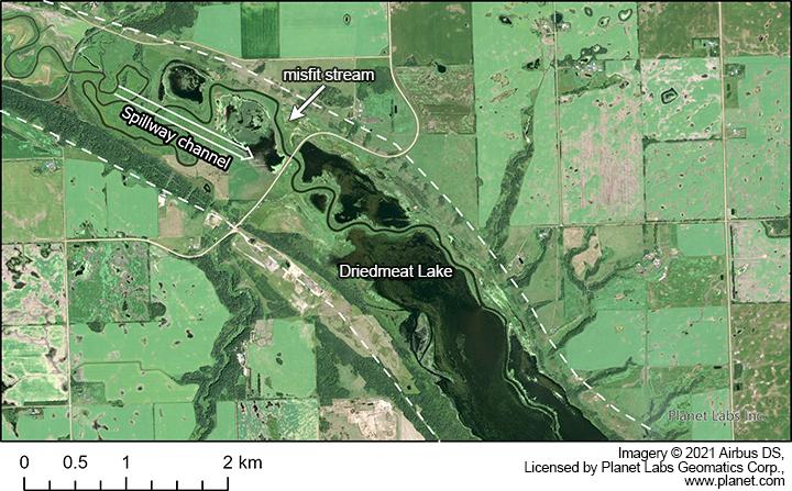
Twenty thousand years ago most of Alberta was covered by the Laurentide and Cordilleran ice sheets. As the Laurentide Ice Sheet melted and retreated, generally towards the northeast, it blocked the natural drainage route, causing large volumes of water from the melting ice to pond in glacial lakes along the ice margin. The meltwater drained from these short-lived lakes through spillways. Today, remnants of these glacial lakes are usually flat extensive plains, composed of fine-grained sediments (glacial lake sediments) that were deposited at the bottom of these glacial lakes. Remnants of the spillways contain what are sometimes called ‘misfit streams’ because the present-day water courses are much smaller than the size of the channel making them look misplaced. Lakes and reservoirs fill many of these melt-water channels in Alberta, such as Chestermere Lake near Calgary, Driedmeat Lake near Camrose in central Alberta, and Chin Lakes east of Lethbridge in southern Alberta.
Image
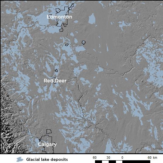
Across Alberta, glacial lake sediments account for approximately one-fifth of the surficial sediment. They predominantly occur as large plains, often used for agriculture. In south-central to central Alberta, glacial lake deposits cover large areas of Edmonton and some portions of Calgary, particularly along the Bow River valley.
In order to understand the positions of the retreating Laurentide Ice Sheet’s margin and the origin and distribution of glacial lake sediments, we reconstructed the extents of former glacial lakes over the whole province. Although glacial lake sediments do not currently cover the entire area each glacial lake covered, either due to erosion or lack of deposition, these reconstructions show the likely locations of those glacial lakes.
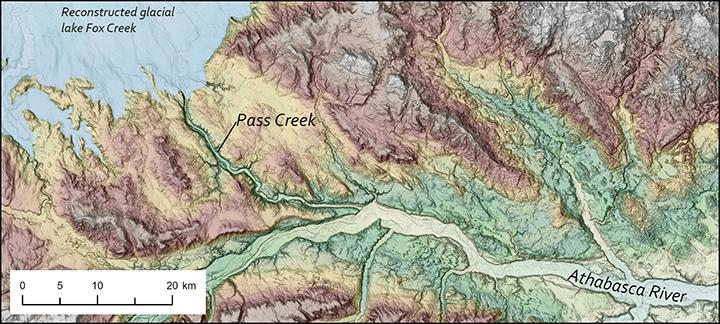
Associated with each glacial lake might be remnants of shorelines, deltas, and outlet channels, as well as fine-grained sediments deposited at the base of the glacial lake. Reconstructing each glacial lake required identifying these associated landforms, especially the outlet channels. For example, to determine the extent of a glacial lake northwest of Edmonton in central Alberta, we looked at Pass Creek, which flows in a channel carved out by melting water from the ice front. When retreating ice blocked meltwater drainage, a glacial lake formed in the lowlands to the north and subsequently drained out through this channel. The outlet channel controlled the water level of the glacial lake; therefore, we projected the extent of the glacial lake to the same elevation as the channel throughout the lowlands to the north.
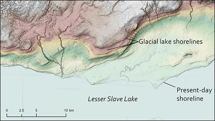
Where possible, we confirmed the extent of reconstructed glacial lakes with remnant shoreline sediments, such as those north of Lesser Slave Lake. Many of these shoreline deposits are very subtle and difficult to observe on the ground, while others form thick sand or coarse deposits.