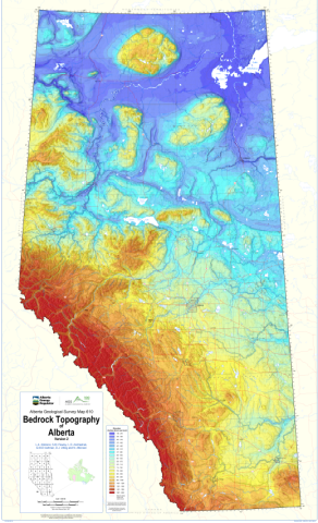
This map depicts the new 1:1 000 000 bedrock topography map of Alberta prepared by the Alberta Geological Survey (AGS). This map updates the bedrock topography portrayed in AGS Map 602.
The bedrock topography of Alberta is the unconformity surface at the top of Upper Cretaceous and Paleogene bedrock and reveals geomorphic features created by Paleogene to Recent river systems and Quaternary glaciation.
In this work, Alberta’s bedrock topography is generated using a machine learning approach to combine numerous subsurface point datasets of varying quality and coverage with 39 geologic (e.g., bedrock and surficial geology) and topographic predictors (e.g., physiographic regions and relative height in the landscape). Previously published information from AGS maps and reports, as well as newly generated data, were used as input point data. A stack of raster-based predictors was used to provide auxiliary information to support the bedrock topography input data by incorporating the statistical relationships between the geological and geomorphological characteristics of Alberta. Integration of multiple datasets and predictors in the Extremely Randomized Trees algorithm resulted in a bedrock topography surface that honors both the subsurface data and the geological interpretation across multiple settings and throughout a diverse range of surficial environments.
Improving the accuracy of the bedrock topography surface is necessary as it represents an important unconformity upon which Neogene-Quaternary sediments were deposited. Knowledge of the position and thickness of these sediments is critical for management of groundwater, aggregate, and energy resources, as well as other land-use applications. The bedrock topography surface is also an important digital product, as it provides the lowermost bounding surface for modelled Neogene-Quaternary sediment units, and is the uppermost bounding surface for bedrock units modelled in the Geological Framework of Alberta. The bedrock topography grid represented in AGS Map 610 is available in AGS Digital Data 2020-0022.
Atkinson, L.A., Pawley, S.M., Andriashek, L.D., Hartman, G.M.D., Utting, D.J. and Atkinson, N. (2020): Bedrock topography of Alberta, version 2; Alberta Energy Regulator / Alberta Geological Survey, AER/AGS Map 610, scale 1:1 000 000.