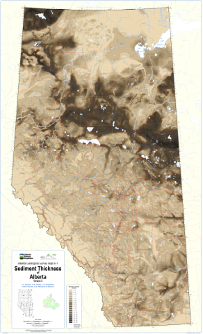
This map depicts the new 1:1 000 000 sediment thickness map of Alberta prepared by the Alberta Geological Survey (AGS). This map updates the sediment thickness portrayed in AGS Map 603.
The thickness and distribution of sediments overlying the bedrock surface in Alberta is highly varied, with modelled values ranging from less that 1 m to as much as 360 m. These sediments include Neogene fluvial deposits, glacigenic materials deposited during Quaternary glaciations, as well as postglacial sediments.
The thickness and distribution of sediments overlying bedrock in Alberta was produced by subtracting a newly revised bedrock topography gridded surface of Alberta that was generated using machine learning techniques from a land surface digital elevation model (DEM). The land surface DEM was generated at a 500 m grid cell size using the aggregate tool in ArcGIS to resample the DEM at a coarser resolution that would be appropriate for a provincial-scale model. The newly generated bedrock topography grid is represented in AGS Map 610, Bedrock Topography of Alberta, Version 2 and available in AGS Digital Data 2020-0022. The sediment thickness grid represented in AGS Map 611 is also available in AGS Digital Data 2020-0023.
Atkinson, L.A., Pawley, S.M., Andriashek, L.D., Hartman, G.M.D., Utting, D.J. and Atkinson, N. (2020): Sediment thickness of Alberta, version 2; Alberta Energy Regulator / Alberta Geological Survey, AER/AGS Map 611, scale 1:1 000 000.