Title Published On Type
    3D Property Model of the Spirit River Formation in Alberta (methodology, model, dataset, multiple files) October 19, 2022 Model View
    Temperature Mapping of Select Devonian Strata in Alberta June 17, 2022 Open File Report View
    Subsurface Temperature Model of Alberta: Point Cloud Data (tabular data, tab-delimited format) June 17, 2022 Data View
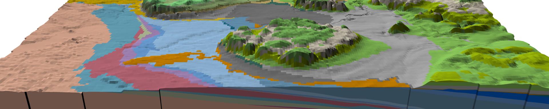
    Geological Framework of Alberta, Version 3 (interactive app and map, methodology, model, dataset, storymaps, web maps) December 07, 2021 Interactive App or Map View
    Grande Prairie–Valleyview Area Hydrostratigraphic Model – Thickness of Hydrostratigraphic Subunit HSU1-High Within the Paleogene–Quaternary Succession (gridded data, ASCII format) December 08, 2020 Data View
    Grande Prairie–Valleyview Area Hydrostratigraphic Model – Thickness of Hydrostratigraphic Unit HSU2 Within the Paleogene–Quaternary Succession (gridded data, ASCII format) December 08, 2020 Data View
    Grande Prairie–Valleyview Area Hydrostratigraphic Model - Thickness of Hydrostratigraphic Subunit HSU1-Low Within the Paleogene–Quaternary Succession (gridded data, ASCII format) December 08, 2020 Data View
    Edmonton–Wabamun Regional Hydrostratigraphic Investigation - Top of Basal Coarse-Grained Sediment Within the Neogene−Quaternary Succession (gridded data, ASCII format) October 28, 2020 Data View
    Sediment Thickness of Alberta, Version 2 (gridded data, ASCII format) October 15, 2020 Data View
    Bedrock Topography of Alberta, Version 2 (gridded data, ASCII format) October 15, 2020 Data View
    Three-Dimensional Property Model of the Uppermost Cretaceous–Paleogene Paskapoo, Porcupine Hills, Scollard, and Willow Creek Formations in West-Central and Southern Alberta (dataset, multiple files) April 20, 2020 Model View
    3D Property Model of the Montney Formation in Alberta, Version 2 (methodology, model, dataset, multiple files) March 16, 2020 Model View
    Three-Dimensional Property Modelling of the Upper Cretaceous Cardium Formation in West-Central and Southern Alberta February 11, 2020 Open File Report View
    Three-Dimensional Property Model of the Upper Cretaceous Cardium Formation in West-Central and Southern Alberta (dataset, multiple files) February 10, 2020 Model View
    2019 Synopsis of Three-dimensional Geological Mapping and Modelling at Geological Survey Organizations October 21, 2019 Special Report View
    Regional Stratigraphic Correlation and 3D Geological Modelling of West-Central Alberta August 15, 2019 Open File Report View
    3D Geological Model of West-Central Alberta (dataset, multiple files) August 15, 2019 Model View
    3D Property Modelling of the Bedrock Hydrostratigraphy in the Fox Creek Area, West-Central Alberta August 14, 2019 Open File Report View
    Three-Dimensional Property Modelling of the Paskapoo, Porcupine Hills, Scollard, and Willow Creek Formations in Southwest Alberta June 13, 2019 Open File Report View
    The 3D Provincial Geological Framework Model of Alberta, Version 2: updating a province-wide 3D geocellular model to incorporate 30 new model zones May 13, 2019 Poster View
    Three-Dimensional Property Modelling of the Montney Formation in Alberta March 27, 2019 Open File Report View
    3D Geological Model of Coal Zones in Central and Southern Alberta (methodology, model, dataset, multiple files) March 27, 2019 Model View
    Three-Dimensional Property Modelling of the Duvernay Formation March 27, 2019 Open File Report View
    Three-Dimensional Property Model of the Montney Formation in Alberta (dataset, multiple files) March 27, 2019 Model View
    Three-Dimensional Property Model of the Duvernay Formation in Alberta (dataset, multiple files) March 27, 2019 Model View
    Dinosaur Provincial Park Minecraft Model: 3D Print Files (digital data, STL format) March 17, 2019 Data View
    Simplified 3D Provincial Geological Framework Model of Alberta (Version 1): 3D Print Files (digital data, STL format) March 17, 2019 Data View
    Southeastern Alberta 3D Geological Model: 3D Print Files (digital data, STL format) March 17, 2019 Data View
    3D Provincial Geological Framework Model of Alberta, Version 2 (methodology, model, dataset, multiple files) January 30, 2019 Model View
    Numerical Groundwater Flow Model of the Sylvan Lake Sub-Basin in the Edmonton-Calgary Corridor, Central Alberta (multiple files, text format) November 25, 2018 Model View
    Numerical Groundwater Flow Model of the Sylvan Lake Sub-Basin in the Edmonton-Calgary Corridor, Central Alberta November 25, 2018 Report View
    3D Provincial Geological Framework Model of Alberta, Version 1 (dataset, multiple files) May 03, 2018 Model View
    3D Provincial Geological Framework Model of Alberta, Version 1 - Methodology May 03, 2018 Open File Report View
    Regional Stratigraphic Mapping and 3D Modelling of the Paleozoic Succession in Northeastern Alberta (Townships 59-104, Ranges 1-19 West of the Fourth Meridian) February 07, 2018 Report View
    Dinosaur Provincial Park Campground Model, Generalized for Minecraft (Minecraft format) October 13, 2017 Model View
    Dinosaur Provincial Park Regional Model, Generalized for Minecraft (Minecraft format) October 13, 2017 Model View
    Precambrian Basement Top Picks in Alberta (Elevation) (tabular data, tab-delimited format) July 13, 2017 Data View
    West-Central Alberta Regional Stratigraphic Model - Top of Stratigraphic Unit 3 Within the Paleogene-Quaternary Succession (gridded data, ASCII format) April 23, 2017 Data View
    3D Rendering of the Regional Stratigraphy of Paleogene-Quaternary Sediments in West-Central Alberta April 23, 2017 Report View
    West-Central Alberta Regional Stratigraphic Model - Bedrock Topography (gridded data, ASCII format) April 23, 2017 Data View
    West-Central Alberta Regional Stratigraphic Model - Top of Stratigraphic Unit 4a Within the Paleogene-Quaternary Succession (gridded data, ASCII format) April 23, 2017 Data View
    West-Central Alberta Regional Stratigraphic Model - Sediment Thickness (gridded data, ASCII format) April 23, 2017 Data View
    West-Central Alberta Regional Stratigraphic Model - Top of Stratigraphic Unit 4b Within the Paleogene-Quaternary Succession (gridded data, ASCII format) April 23, 2017 Data View
    West-Central Alberta Regional Stratigraphic Model - Top of Stratigraphic Unit 1 Within the Paleogene-Quaternary Succession (gridded data, ASCII format) April 23, 2017 Data View
    West-Central Alberta Regional Stratigraphic Model - Top of Stratigraphic Unit 5 Within the Paleogene-Quaternary Succession (gridded data, ASCII format) April 23, 2017 Data View
    Transparent 3D Geological Model of the Peace River Area, Generalized for Minecraft (Minecraft format) April 12, 2017 Information Series View
    Solid 3D Geological Model of the Peace River Area, Generalized for Minecraft (Minecraft format) April 12, 2017 Information Series View
    Hollow 3D Geological Model with Guided Tour of the Peace River Area, Generalized for Minecraft (Minecraft format) April 12, 2017 Information Series View
    Calgary-Lethbridge Corridor Hydrostratigraphic Model - Top of the Pakowki / Upper Lea Park Hydrostratigraphic Unit, Southwestern Alberta (gridded data, ASCII format) March 28, 2017 Data View
    Calgary-Lethbridge Corridor Hydrostratigraphic Model - Top of the Scollard / Willow Creek Hydrostratigraphic Unit, Southwestern Alberta (gridded data, ASCII format) March 28, 2017 Data View