Mapping and Modelling Groundwater Systems
Our regional aquifer characterization projects focus on mapping and modelling groundwater systems in Alberta. This includes both deep and shallow groundwater resources. These projects can include the following three key aspects:
- developing hydrostratigraphic models, which simulate the geological container where groundwater flows
- describing the physical and chemical characteristics of aquifers, aquitards, and groundwater
numerically modelling groundwater flow to provide a dynamic understanding of flow
Image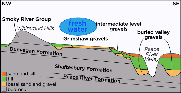
More About Regional Aquifer Characterization
Mapping aquifers or groundwater systems requires that we understand the geological container through which groundwater flows. We build hydrostratigraphic models to help us describe these geological containers and identify aquifers and aquitards in Alberta. These models may take on different forms ranging from conceptual diagrams to digital 3D models with top and bottom elevations of individual units (e.g., our Calgary-Lethbridge Corridor 3D modelling).
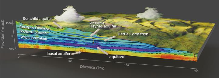
We develop hydrostratigraphic models using a variety of data from several sources including lithological and geophysical logs from water, oil, and gas wells. In some cases, we also model bedrock sandiness to help develop the hydrostratigraphy, such as our work within the Paskapoo Formation and in west-central Alberta.
Regional hydrostratigraphic modelling of the sediments above bedrock can help us identify sand and gravel that may form aquifers or act as recharge windows. For example, our study in west-central Alberta identified recharge windows where permeable sandy bedrock was overlain by sand and gravel units.
Learn More About:
Modelled sand and gravel units above bedrock in west-central Alberta
3D property modelling in west-central Alberta bedrock
3D modelling in the Calgary-Lethbridge Corridor Paskapoo Formation hydrostratigraphic units
3D property modelling in southwest Alberta
Our groundwater characterization work describes the physical and chemical characteristics of aquifers, aquitards, and groundwater. This work includes understanding many different aspects of the groundwater system including groundwater quality, flow, and storage.
We use a range of data, methods, and tools to characterize groundwater in Alberta for a variety of purposes, some examples are:
- property models showing sandiness in bedrock units, which help us identify hydraulic connections between and within different hydrostratigraphic units
- permeability data (e.g., from pumping tests) to help us determine how easily water flows through the subsurface
- maps of hydraulic head, water quality, vertical gradients, recharge, and discharge to help us conceptualize and illustrate these groundwater flow systems

Products from our groundwater characterization work provide information for Albertans on the occurrence, availability, and movement of groundwater in our province. Characterizing deep saline groundwater resources helps us understand
- industrial use of groundwater,
- underground disposal of wastewater,
- gas migration in the subsurface, and
- geothermal resources.
Characterizing shallow non-saline groundwater resources is important because this water is used for drinking water and sustaining wetlands and rivers, which are important to Albertans and our environment.
Learn More About:
Disposing carbon dioxide (CO2) in aquifers
Mapping saline aquifers in west-central Alberta
Geology and hydrogeology for coalbed-methane
Natural Hydraulic pathways and coalbed-methane
Commingled well abandonment in southeastern Alberta
Simulation of geothermal flow
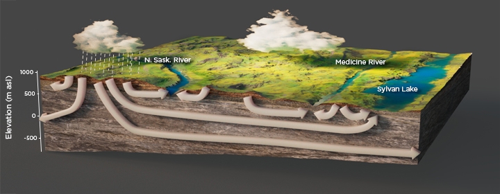
We use numerical models of groundwater flow and transport to simulate the dynamics of hydrogeological systems. These simulations help us calculate natural water balances and transfers between deep and shallow groundwater systems, and between shallow groundwater systems and surface water. For example, we constructed a groundwater flow model in the Sylvan Lake area to aid the municipality with their groundwater management strategy in an area where water management is challenging due to a high population, increasing water supply needs, industrial activity, and the presence of two large lakes popular for recreational use.
Learn More About:
Sylvan Lake groundwater management
The Risk of gas migration into aquifers in southern Alberta
The Effect of Groundwater pumping on surface water bodies